31L11NW MCAUSLAN 010 A REPORT ON A RECONNAISANCE GEOLOGY SURVEY PROJECT
|
|
|
- Austin Small
- 5 years ago
- Views:
Transcription
1 31L11NW MCAUSLAN A REPORT ON A RECONNAISANCE GEOLOGY SURVEY PROJECT IN MCAUSLAN TOWNSHIP, ONTARIO FOR CENTRAL ONTARIO NATURAL STONE COMPANY LIMITED,o RECEIVED JUN l MINING LANDS Raymond L. Lashbrook June 26, 1992
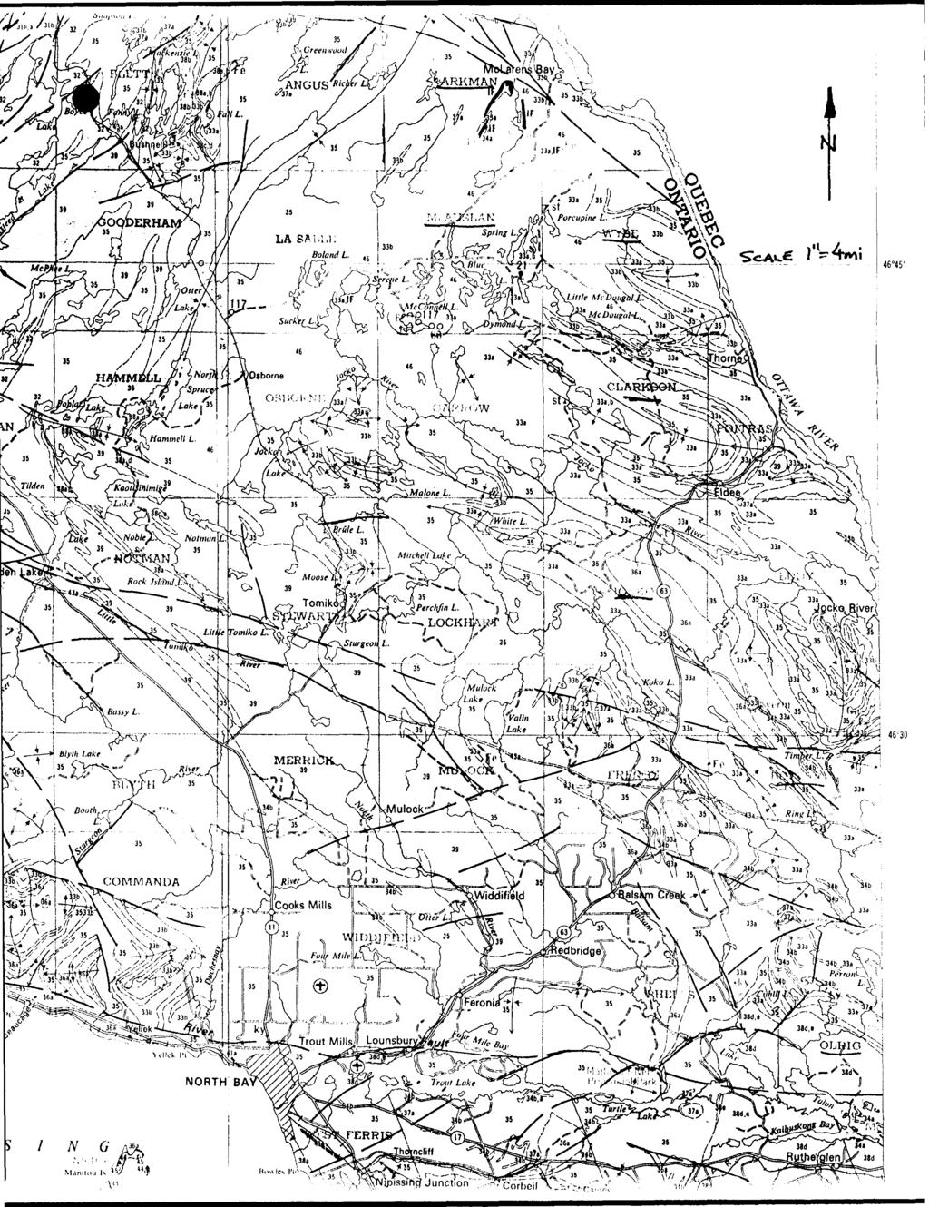
2 31L11NW9557 Z MCAUSLAN 010C INDEX PAGE INTRODUCTION LOCATION AND ACCESS PROPERTY PREVIOUS WORK REGIONAL GEOLOGY TRAVERSE l TRAVERSE 2 TRAVERSE 3 TRAVERSE 4 TRAVERSE 5 CONCLUSION RECOMMENDATIONS APPENDIX CERTIFICATE TRAVERSE MAPS - Raymond L.Lashbrook June 26, 1992
3 (1) INTRODUCTION Five days (June 18,19,20 S 22,23/1992) were spent on reconnaissance geology traverses in the Mcconnell Lake area, McAuslan Township. The purpose was to try and locate new showings of amblygonite and lepidolite for quarrying. The minerals occur in a quartzose rock. Amblygonite (L1A1FP04) imparts a light to medium green colour to the rock and lepidolite (K2Li3A13(AlSi3010)2(0,OH,F)4 gives a rose to pink colour. The quarried rock is used as a building decorative stone. The traverses were successful in locating some float pieces and in-place sources similar to that being quarried at Reynolds Lake.
4 (2) LOCATION AND ACCESS McAuslan Township is located approximately 50 kilometers northnortheast of North Bay along the border between N.T.S. 31-L/ll and 31-L/14. The area can be reached via highway 63 between North Bay, Ont. and Temiscaming, Quebec, then north along a bush road called the Mcconnell Lake Road for approximately 20 kilometers. PROPERTY One claim numbered is currently held by Mr. John Pilger R.R.#5 Orillia, Ont. L3V 6H5 This survey spent two days on this property and 3 days in the surrounding area. PREVIOUS WORK The area has been prospected for many years with production of decorative stone from quarries at Reynolds Lake and Three Trails Lake. The quarry at Reynolds Lake is still active. The reader is referred to the files located at the Minstry of Northern Development and Mines in Sudbury for a complete history of exploration in this area.....3
5 (3) REGIONAL GEOLOGY The area is located in the northern portion of the Central Gneiss Belt of the Grenville Province. This part of the belt is mainly underlain by metasediments and are represented as biotite, muscovite, quartzose and feldspathic gneisses. In Parkman Township iron formations are interbedded in the gneisses. Intruded into these rocks are gneissic felsic rocks consisting of quartz monzonites, granodiorit.es and trondhjemites and mafic rocks consisting of anorthosite, gabbro, diorite and amphibolite. To the west and southwest of the area the Mullock granite batholith is exposed over an area of about 530 square kilometers. Generally the rocks trend in a southeast direction but as they approach the Grenville Front Tectonic Zone they change to a northeast direction. TRAVERSE GEOLOGY Five days were spent doing reconnaissance geology in McAuslan Twp. The traverses are described below and are outlined on the accompan ying map at a scale of 1:20,000. A declination o f. 1 0 degrees west was used for the traverses. Traverse l - Day one was spent on claim north of Threetrails Lake. Stripping of outcrops exposed mainly quartzites and biotite gneisses. One outcrop area about 400' south and 200' east of #4 post of claim contained some fair concentations of greenish amblygonite. About 300' east another outcrop near the....4
6 (4) base of the hill contained good amblygonite over narrow widths. Traverse 2 - This traverse, on day two, was located along the east side of claim The hill is mainly covered with overburden but outcrops of quartzite and biotite gneiss were located. Along the west side of this hill a large angular piece of float (2'x4'xl') was found that contained excellent coarse amblygonite very similar as to that being quarried at Reynolds Lake. Further work in this general area failed to locate the source of this piece. Traverse 3 - The traverse on day 3 was located approximately one kilometer southeast of Threetrails Lake. Stripping and mapping along the two hills only uncovered gneissic hornblende granite. Traverse 4 - Day 4 was spent mapping a hill to the east of Threetrails Lake. Most of the hill was covered with thin overburden which gets thicker towards the south until no outcrop could be located. The rocks encountered were quartzites mainly on the west side of the hill and mixed quartzites and micaceous quartzites on the east side. A float boulder about 4"x 8"x l' was located along the west side of the hill and contained good amblygonite. This piece is similar to the stone that was quarried about l kilometer north. On the east side, a fault zone exposed near the base of the hill contained quartz veins and amblygonite. Tracing of this zone was unsuccessful due to overburden and talus.....5
7 (5) Traverse 5 - Day 5 was spent on a traverse to the east of Reynolds Lake. During the walk in several pits were quickly looked at that had been quarried for amblygonite and lepidolite. To the east of the patent claims the rocks on the first hill were biotite gneisses and quartzites. Some of the layers in the gneiss contains up to 1 0^ b iotite over a few feet. On the east facing slope of the hill narrow horizons of chert-jasper were found along with highly contorted beds of cherty rock further south and along the west side of a south flowing creek. These metasedimentary rocks may be part of an iron formation horizon located further north in Parkman Township. To the east of the creek the outcrops were quartzites and micaceous quartzites. The outcrop on the west sloping face of the hill contains several narrow horizons of a coarse white to pearly muscovite. A slight greenish colour to some layers may be caused from weak amblygonite mineralization. CONCLUSION The 5 day reconnaissance geology program in McAuslan Township was successful in locating several in-place potential sources of ambly gonite and in locating 2 float pieces containing good amblygonite. The sources of the float pieces are probably not the past or present quarries in the area. It is probable that several horizons in the metasediments exist that are potential sources for quarrying decorative stone. Intensive follow-up mapping should be able to locate new quarry sites..... b
8 (6) RECOMMENDATIONS The following program is recommended as a follow-up to the present program : (a) At least 2 claims be staked to cover the hill to the east of Threetrails Lake (Traverse 4). (b) At least another 5 days of reconnaissance geology should be conducted on the hills to the north, east and south of Reynolds Lake. A plugger and dynamite should be used on favourable locations to obtain fresh samples. (c) A backhoe should be used on claim to better expose the new amblygonite showings found and if the claims are staked to the east of Threetrails Lake it should also be used there. (d) Quarry permits should be applied for to cover all of the favourable sites and/or staking of claims.
9 APPENDIX
10 CERTIFICATE I, Raymond L. Lashbrook do hereby declare that (a) I have no interest in the property nor do I expect to have any interest in the property (b) I graduated from Haileybury School of Mines in 1969 and have been practising my profession ever since. (c) I own a company called Lashex Ltd. which performed the reconnaisance geology program. (d) I reside at 973 Pinecreek Road, Callander, Ontario, POH 1HO Raymond L. Lashbrook June 26, 1992
11 46 045'

12 l \
13 CL 101 LE6EMD 2 - l - ^luar^a/ftf (Qua r ^a i t r TRAVERSES ** MtAUSUAM BCALE T! g. OOP o/vtf -r,,,,- -. :. OH AWN f.
14
15
16
17 Ontario Ministry of Northern Development and Mines July 29, 1993 Mining Recorder Ministry of Northern Development and Mines 933 Ramsey Lake Road 3rd Floor Sudbury, Ontario P3E 6B5 Dear Sir/Madam: Ministere du DeA/eloppement du Nord et des Mines 31U1NW MCAUSLAN 900 Geoscience Approvals Section 933 Ramsey Lake Road 6th Floor Sudbury, Ontario P3E 6B5 Telephone: Fax: (705) (705) Our File: Transaction #: W Subject: APPROVAL OF ASSESSMENT WORK CREDITS ON MINING CLAIMS S ET AL IN MCAUSLAN TOWNSHIP The assessment work credits for Reconnaissance Geology, Section 12 of the Mining Act Regulations, have been approved as outlined on the original submission. The approval date is July 28, If you have any questions regarding this correspondence, please contact Lucille Jerome at (705) Yours sincerely, iz&tj&zs'' Ron C. Gashinski Senior Manager, Mining Lands Section Mining and Land Management Branch Mines and Minerals Division li j /dm ^ cc: Resident Geologist Sudbury, Ontario Assessment Files Library, Toronto, Ontario

18 Ontario Ministry of.northern Development and. Mines Report of Work Conducted After Recording Claim Mining Act Personal information collected on this form Is obtained under the authority of the Mining Act. This information this collection should be directed to the Provincial Manager, Mining Lands, Ministry of Northern Developm Sudbury, Ontario, P3E 6A5, telephone (705) Transaction Number be^sed fi t and Mine?, FoTTrth about, 159 Cedar Street, Instructions: - Please type or print and submit in duplicate. - Refer to the Mining Act and Regulations for requirements of fill ng assessme Recorder. - A separate copy of this form must be completed for each Work Group, - Technical reports and maps must accompany this form in dupli cat e. - A sketch, showing the claims the work is assigned to, must aceompany this RECEIVED it work or consulrme N ning JUW1993 -/^v MNW6LANn.^ Nn, Recorded Holder(s) _ ^^ Address ^r\ f^ ^^ - Client No. ^ Telephone No. Mining Division p., ' Township/Area M or G Plan No. 3 (X 610 M tf c/ /^lr fr-7l^j'/^ SI/ Dates ' f Work From: ~~r~ 0 j ' To: 'i,.. i. Performed w tx-a^c l i* /*t 2- t^-ajc ^-v* /*t *^ Work Performed (Check One Work Group Only) Work Group Geotechnical Survey Physical Work, Including Drilling Rehabilitation Other Authorized Work Assays Assignment from Reserve f?^c*)a)a^aaj^ Type rf^t^^x HtCEIVED JUN MINING LANDS BRA uou "^^^^^ ftwi^iiiiijj^l Total Assessment Work Claimed on the Attached Statement of Costs $ Note: RECORDED WAY (M993 ^^^^ SJI^BKBHHMI /, O^C5 ^ ^ ^^ MM The Minister may reject for assessment work credit all or part of the assessment work submitted if the recorded holder cannot verify expenditures claimed in the statement of costs within 30 days of a request for verification. Persons and Survey Company Who Performed the Work (Give Name and Address of Author of Report) Name Address if* in? C ' (attach a schedule If necessary) Certification of Beneficial Interest * See Note No. 1 on reverse side Date l certify that at the time the work was performed, the claims covered In this work report were recorded in the current holder's name or held under a beneficial interest by the current recorded holder. Recorded Holder or Aoent (Signature) Certification of Work Report l certify that l have a personal knowledge of the facts set forth in this Work report, having performed the work or witnessed same during and/or after Its completion and annexed report Is true. Name and Address of Person Certifying S l, et Qua. Ml*l3 )ate Noticejfor Amehdmenti idments Sent RECEIVED A. M MAY (03^1)
19 4 1 h i I Credits you are claiming in this report may be cut back. In order to minimize the adverse effects of such deletions, please indicate from which claims you wish to priorize the deletion of credits. Please mark (**) one of the following: 1. D Credits are to be cut back starting with the claim listed last, working backwards. 2. El Credits are to be cut back equally over all claims contained in this report of work. 3. D Credits are to be cut back as priorized on the attached appendix. In the event that you have not specified your choice of priority, option one will be implemented. i 1 T. ' ' - : H y] i Note 1 i Examples of beneflclatlnterest are unrecorded transfers, option agreements, memorandum of agreements, etc., with respect ; to the mining claims. Note 2; Mf work has been performed ' on patented or leased land, please complete the following: l certify that the recorded holder had a beneficial interest in the patented or leased land at the time the work was performed. Signature Date vw

20 Ontario Ministry of Northern Development and Mines Utfveloppement du Nord et des mine* Statement of Costs for Assessment Credit ttat des coott aux fins du credit devaluation Mining Act/Lol sur les mines Transaction No./N" de trai Personal information collected on this form Is obtained under the authority o* the Mining Act. This information will be used to maintain a record and ongoing status of the mining claim(s). Questions about this collection should b* directed to the Provincial Manager, Minings Unda. Ministry of Northern Development and Mines, 4th Floor, 159 Cedar Street, Sudbury, Ontario P3E 6AS. telephone (705) Les renseignements personnels contenus dans la presente formule sont recueillis en vertu de la Lot aur lee mines et serviront k tenir a jour un reglstre des concessions minieres. Adresser toute question sur la collece de ces reneeignements au chef provincial des terrains miniers, mlnistere du Devetoppement du Nord et des Mines, 159, rue Cedar, 4* etage. Sudbury (Ontario) P3E 6A5. telephone (705) Direct Costs/Gouts directs Type Wegee Salalres Contractor's and Consultant's Fee* Drafts de ('entrepreneur et d* ('expertconeem SuppfleeUsed Fournltures utilises* Description Labour Maln-d'oeuvre Field Supervision Supervision sur le terrain T)T ^y*x^* KtC tti'vi 14 4/j fli f (rtv/. AAtp /tyys/sfy* Type Amount Montan! -^'{' tj~m Totals Total global y^fe 2. Indirect Costs/Gouts Indirect! * * Note: When claiming Rehabilitation work Indirect costs are not allowable as assessment work. Pour le remboureement des travaux de rehabilitation, les coots indlrects ne sont pas admissible* en (ant que travaux d'evaluatton. Type Transportation Transport Food and Lodging Nourrrturt et Typ* Description 2^ Amount Montant ^^ Totals Total global So Equipment Rental Location de materiel Type Total Direct Costs Total dea coota directs.' - ' ' "- v /0*0 Mobilization and Demobilization Mobilisation et d4moblllwrtkm Sub Total of Indirect Costs Totsl partial des coots Indlrects Amount Allowable (not greater than 20H of Direct Coats) Montant admissible (n'excedant pas 20 H des coots directs) Total Value of Assessment Credit (Total of Direct and Allowable Indirect costs) Valeur totals du credit d'tvskiatlon (Total dst cote dined St Mrects sdmtemet - 1&& fate Note: The recorded holder will be required to verify expenditures claimed in this statement of costs within 30 days of a request for verification. If verification is not made, the Minister may reject for assessment work all or part of the assessment work submitted. Note : Le titulaire enregistre sera tenu de verifier les depenses demandees dans le present etat des couts dans les 30 jours suivant une demande a cet effet. Si la verification n'est pas effectuee, le minlstre peut rejeter tout ou une partie des travaux devaluation presentes. Filing Discounts 1. Work filed within two years of completion is claimed at 100^ of the above Total Value of Assessment Credit. 2. Work filed three, four or five years after completion Is claimed at 50^ of the above Total Value of Assessment Credit. See calculations below: Remises pour depot 1. Les travaux deposes dans les deux ans suivant tour achevement sont rembourses a 100 to de la valeur totale susmenttonnee du credit devaluation. 2. Les travaux deposes trois, quatre ou cinq ans apres leur achevement sont rembourses a 50 M) de la valeur totale du credit devaluation ausmentionne. Volr les calculs ci-dessous. Total Value of Assessment Credit x Total Assessment Claimed Valeur totale du credit devaluation x 0,50 - Evaluation totale demandee RECEIVED Certification Verifying Statement of Costs Attestation de I'etat des coqts JUN l hereby certify: that the amounts shown are as accurate as possible and these costs were incurred while conducting assessment work on the lands shown on the accompanying Report of Work form. J'atteste par la presente : MINING LAND: nija^l, depenses ont et6 engagees pour effectuer les travaux devaluation sur les terrains Indiques dans la formule de rapport de travail ci-joint. that as i ^ &A (Recorded Holder, Agent. Position In Company) to make this certification l am authorized Et qu'a litre de je suis autorise* (thulalr* enrtglttr*. rtprisanunt. pom* occyp* dans la compagnl*} a faire cette attestation. 021? (04/91) Nota : Dans cette formule. Oorsqu'il designe des personnes, le masculin est utilise au sens neutre.

21 Ontario Ministry of Northern Development kl Mines Report of Work Conducted Before Recording Claim Mining Act Transaction Number Personal information collected on this form is obtained under the authority of the Mining Act. This information will be used for correspondence. Questions about this collection should be directed to the Provincial Manager, Mining Lands, Ministry of Northern Development and Mines, Fourth Floor, 159 Cedar Street, Sudbury, Ontario, P3E 6A5, telephone (705) f^ ^ ^ f^ /\ M Instructions: 6 * l O O O TC - Please type or print and submit in duplicate. - Refer to the Mining Act and Regulations for requirements of filing assessment work or consult the Mining Recorder. - A separate copy of this form must be completed for each Work Group. - Technical reports and maps must accompany this form in duplicate. - A sketch, showing the claims the work is assigned to, must accompany this form. Recorded Holders) Client No. Address /rf g. Telephone No. Mining Division Township/Area M or Q Plan No. Oates Work Performed From:. S J 977 j Z To: -T -J fit Work Performed (Check One Work Group Only) Work Group Type i* 'Regional Surveys Prospecting &COAS**,***** ^^^x Total Assessment Work Claimed on the Attached Statement of Costs Note: The Minister may reject for assessment work credit all or part of the assessment work submitted if the recorded holder cannot verify expenditures claimed in the statement of costs within 30 days of a request for verification. Persons and Survey Company Who Performed the Work (Give Name and Address of Author of Report) Name Mf hfltfg/zott ~ bfr/fex. ^Tp (attach a schedule If necessary) S Address 373 S?*/,? fy&rtl x^j. {21*^*4***? so^/r RECEIVED JUN MINING LANDS BRANCH ^A..^lJtA. KAtA H A.J Eft A. M ^.J *.t A LA AH*. AA * 0 AA LI A* A MA. 4 AM MAXAMAA Mhl*Jjh ^^ RECORDED 4 MAY Receipt jzilj. /^/^//yo RECEIVED JUN ^!993 FINING LANDS UDA^f, ihe-ttme-the work was performed, the claims covered In thla work report were recorded in the current holder's name or held t Date Recorded Holder or Agent (Signature) Certification of Work Report l certify that l have a personal knowledge of the facts set forth in this work report, having performed the work or witnessed It during and/or after its completion, and the annexed report is true. Name and Address of Pereon Certifying SUDBURY MINING DIV. R"E C E l V E D Date Notice* for Amendments Sent 0240(03/91)
22 ' 1 Subsequently ofcwms Done Number Appled Assigned Value Work Reserve Total Oo *' o N^j i -*± t s ^ M 1-35 ^ * ^ i ih Subsequently Staked as this Claim Done Land Value of Work Staked as Claim this Subsequently Land From Work Done V N M jpf 5 li 1 1 V ^^j i^^k "i \ i ^ 1 i Future Date Work bs to Claimed Reserve: Cr Jditsy ou are claiming in this report may be cut back. In order to minimize the adverse effects of such deletions, please Indicate from whlchcl alms you wish to priorize the deletion of credits. Please mark (*x) one of the following: 1. D( Credits are to be cut back starting with the claim listed last, working backwards. 2...tfjc i Credits are to be cut. back equally over all claims contained in this report of work. "A* Credits are tot bq-ctipack as priorized on the attached appendix. In the event that you Have not specified your choice of priority, option one will be implemented. '\ i Note 1: Examples of beneficial Interest are unrecorded transfers, option agreements, memorandum of agreements, etc., with respect to the mining claims.

23 Ontario Ministry of Northern Development and Mines.istere du loppement du Nord et des mines Statement of Costs for Assessment Credit fetat des coots aux fins du credit devaluation Mining Act/Lol sur les mines Transaction NoVN* de transaction Personal information collected on this form Is obtained under the authority of (h* Mining Act. This Information will be used lo maintain a record and ongoing status of the mining clalm(s). Questions about this collection should be directed to the Provincial Manager, Minings Lands, Ministry of Northern Development and Mines, 4th Floor, 159 Cedar Street, Sudbury, Ontario P3E 6A5, telephone (705) Les renseignemenls personnels contenus dans la presente formula tom recueillis en vertu de la Lot sur lea mines et sen/iron! a tenir a jour un registry des concessions minieres. Adresser toute quesiton sur la collece de ces renseignements au chef provincial des terrains miniers, mlnistere du Developpement du Nord et des Mines, 159. rue Cedar, 4* etage. Sudbury (Ontario) P3E 6A5, telephone (705) , 1. Direct Costs/CoQU directs Type Wagee Salalrea Contractor's and Consultant's Fees Droll* d* ('entrepreneur t d* ('expertoortmll Suppllee Used Foiimttures utlll*4e* Description Labour Main-d'oeuvre Field Supervision Supervision sur le terrain ^ 36yK*ttfa ft c c&ajjasaisjjijzai ifx*t.*0f Type ' Amount Montan! 7^o Totals Total global ^ *i?: ' :^s^ 2. Indirect Costs/CoQts Indlrects ' * Note: When claiming Rehabilitation work Indirect costs are not allowable as assessment work. Pour le remboursement des travaux de rehabilitation, les coots Indlrects ne sont pas admissible* en tant que travaux devaluation. Type Transportation Transport Type Description "Jrttt.*- Amount Montan! /ssr Totals Total global l Equipment Rent*) Location d* materiel Type Total Direct Coats Total des coots directs ' :#fe Y'- '.' ' : ' &0 Food and Lodging Nourrlture et h4bergement Mobilization and Demobilization Mobilisation et demobilisation Sub Total of Indirect Costa Total partial de* coot* Indirect* Amount Allowable (not greater than 20H of Direct Costa) Montan! admissible (n'excedant pas 20 H des coots directs) Total Value of Assessment Credit Valeur totale du credit (Total of Direct and Allowable d ' valuation Indirect eottt) (Total dm coott dlrtcts W^ -- i {'W 97? Note: The recorded holder will be required to verify expenditures claimed in this statement of costs within 30 days of a request for verification. If verification is not made, the Minister may reject for assessment work all or part of the assessment work submitted. Note : Le titulaire enregistre" sera tenu de le present etat des couts dans le: 30 jours suivant une demande effet. Si la verification n'est pas t fectuee,, le ministre peut rejeter ou une partie des travaux d'eva ans cet out Filing Discounts Remises pour dtpot MINING LANDS BRANCH 1. Work filed within two years of completion is claimed at 1001*) of the above Total Value of Assessment Credit. 2. Work filed three, four or five years after completion Is claimed at SOty of the above Total Value of Assessment Credit. See calculations below: Total Value of Assessment Credit x Total Assessment Claimed 1. Les travaux deposes dans les deux ans suivant leur achevement sont rembourses a 100 ^ de la valeur totale susmenttonnee du credit (revaluation. 2. Les travaux deposes trois, quatre ou cinq ans apres leur achevement sont rembourses a 50 ^ de la valeur totale du credit devaluation susmentionne. Volr les calculs ci-dessous. Valeur totale du credit devaluation x 0.50 Evaluation totale demandee Certification Verifying Statement of Costs l hereby certify: that the amounts shown are as accurate as possible and these costs were Incurred while conducting assessment work on the lands shown on the accompanying Report of Work form. Attestation de I'etat des couts J'atteste par la presente : que les montants Indiques sont le plus exact possible et que ces depenses ont ete engagees pour effectuer les travaux devaluation sur les terrains indiques dans la formula de rapport de travail ci-joint. that as "('RecofdeTHoldef/Agent, Potion In Company) l am authorized Et qu'a litre de je suis autorise* ' (iftulalro enregitirt, repretontint. potto occup* dans la compagnio) to make this certification a faire cette attestation. Om (04/911 Nota : Dans cetle tormule. lewqu'il designe des pertonnet, le mstculin ett utilit* au tent neutre

24 LASALLE TWR ';. -V-*?--l ~ --'* *v i: i h...j IffffffirfJWIifp,, i If *..;r i-i S If If '?f S' '"-Is- '"-'s ' WYSE TWP.
42AeSNEeSe GODFREY ASSESSMENT WORK FOR RICHARD MATHIEU ON THE GODFREY TOWNSHIP PROPERTY TIMMINS, ONTARIO RECEIVED MINING LANDS BRANCH
 42AeSNEeSe7 2.14685 GODFREY 010 ASSESSMENT WORK FOR RICHARD MATHIEU ON THE GODFREY TOWNSHIP PROPERTY TIMMINS, ONTARIO RECEIVED AUG13 1992 MINING LANDS BRANCH PROSPECTING WORK (a) CLAIM LOCATION Area:...
We are committed to providing accessible customer service. If you need accessible formats or communications supports, please contact us.
 We are committed to providing accessible customer service. If you need accessible formats or communications supports, please contact us. Nous tenons à améliorer l accessibilité des services à la clientèle.
RECEIVED. for Sharpmin Developments Incorporated FEB Geologist January 4, 1996 Toronto, Ontario MINING LANDS BRANCH
 31F06NE0001 2 164OO SEBASTOPOL 010 Analytical Results for Apatite Samples from Turner's Island, Island 'D', Mining Claim SO 1150877, Sebastopol Township, Renfrew County, Southern Ontario Mining Division
Magnetometer Survey on the
 42E13NE8400 2.15192 CASTLEWOOD LAKE 010 Magnetometer Survey on the FOUNDER RESOURCES INC. Conglomerate Lake Property Castlewood Area/ Ontario District of Thunder Bay Oct. 15, 1993 By: Barbara Kowalski
2. i. GEOLOGY Vincent Twp., Ontario NTS 42E/12. By: Barbara Kowalski FOUNDER RESOURCES INC. 42E12NE VINCENT
 42E12NE0062 2.15658 VINCENT 010 2. i FOUNDER RESOURCES INC. GEOLOGY Vincent Twp., Ontario NTS 42E/12 September 21, 1994 By: Barbara Kowalski 42E12NE0062 2.15658 VINCENT 010C TABLE OF CONTENTS TITLE PAGE
Within. Mineral Claim
 31E12SE2001 2.19268 RYERSON 010 2.19-68 January 15,1999 ASSESSMENT REPORT ON A GEOLOGICAL MAPPING PROJECT Within Mineral Claim 1077246 Ryerson Township, Southern Ontario TABLE OF CONTENTS 1. Summary And
DIAMOND DRILLING NOTES: 1. W , filed July 19/93. TWyARKA Scapa REPORT NO. WORK 1'KUKOIIMKD l.\)i^oranda Ex P loration Co - Ltd -
i^oranda Ex P loration Co - Ltd -") 3aE04SW934B l SCAPA 00 DIAMOND DRIING TWyARKA Scapa REPORT NO. WORK 'KUKOIIMKD l.\)i^oranda Ex P loration Co - td - RKOORDKn HOUWIl: SAME AS ABOVE f X l : OTHER! j CIAIM NO. 590 HOK NO. SC-90- FOOTAGE
3aE04SW934B l SCAPA 00 DIAMOND DRIING TWyARKA Scapa REPORT NO. WORK 'KUKOIIMKD l.\)i^oranda Ex P loration Co - td - RKOORDKn HOUWIl: SAME AS ABOVE f X l : OTHER! j CIAIM NO. 590 HOK NO. SC-90- FOOTAGE
BLACK PEARL MINERALS INC.
 52F07SE0008 2.16968 MEGGISI LAKE 010 BLACK PEARL MINERALS INC. GEOPHYSICAL SURVEYS «SUNSHINE LAKE PROPERTY» Octobre 1996 «* TABLE OF CONTENTS I - INTRODUCTION P. 1 II - PROPERTY P. 1 III - LOCATION & ACCESSIBILITY
. QOtSI. Timmins Area. Geological Report NE Eldorodo Township Property. June, 1994 D R. 42A06SE M93E DORADO "" 010
 . QOtSI 42A06SE00462 1M93E DORADO "" 010 Geological Report NE Eldorodo Township Property Timmins Area June, 1994 D R. mile Langmuir Tp. - M.292 Geological Report NE Eldorodo Township Property Timmins Area
XRAL X-RAY Bharti Engineering Associates Inc Lasalle Blvd. P O Box 2336 Sudbury (M P3A4S8. DATE SUBMITTED 9-Aug-89
 XRAL X-RAY 1885 LESLIE S TEL: (416)445 41113SE9429 2.12731 ULSTER 010 C ERT X F X O A.T E TO: BHARTI ENGINEERING ASSOCIATES INC. ATTN: HAROLD J. TRACANELLI 1009 LASALLE BLVD P.O. BOX 2336 SUDBURY, ONTARIO
PROSPECTING REPORT THE WALLACE CLAIM OMENICA MINING DIVISION. 54" x6" 3.d d. for. Reako Exlorat ions Ltd. Wallace Rev. C.G.
 PROSPECTING REPORT ON THE WALLACE CLAIM OMENICA MINING DIVISION 54"44 14 1x6" 3.d d by David A. Howard P.Eng. for Reako Exlorat ions Ltd. Claim Locat ion Wallace Rev. C.G. #1560 Dome Mountain Area 9 3
Simplified exploration work report
 Simplified exploration work report Work Report of exploration and examination of outcrops of rock and boulders Report on stripping and excavating work of $ 5 000 or less.(section 81 of regulation) Report
RECEIVED MINING LANDS SECTION. a.9535 MCTAVISH. E.A. JENNINGS, H.D.Se. Thunder Bay, Ontario September GEOLOGY OF THE THUNDER BAY AMETHYST MINE
 a.9535 MCTAVISH 010 GEOLOGY OF THE THUNDER BAY AMETHYST MINE AND PRECIOUS PURPLE GEMSTOHES CLAIMS E.A. JENNINGS, H.D.Se. Thunder Bay, Ontario September 30 1985 RECEIVED MOV l o 1986 MINING LANDS SECTION
REPORT OF MAGNETOMETER SURVEY ON TB RICKABY 8 LAPIERRE TOWNSHIPS THUNDER BAY MINING DIVISION THUNDER BAY, ONTARIO RECEIVED
 42E14SW0017 2.15545 LAPIERRE LAKE 010 REPORT OF MAGNETOMETER SURVEY ON TB1196017 RICKABY 8 LAPIERRE TOWNSHIPS THUNDER BAY MINING DIVISION THUNDER BAY, ONTARIO 2.15545 RECEIVED AUG 2 9 1994 ' MINING UkNDS
NELSON GRANITE LIMITED. Test Quarrying, Sample Block Removal. Sawing and Polishing Tests. Mining Claim K-l Kilgour Lake Area NTS: 52K 4SW
 l 52K04SW2005 2.20708 KILGOUR LAKE 010 2.20708 NELSON GRANITE LIMITED Test Quarrying, Sample Block Removal Sawing and Polishing Tests Mining Claim K-l 149856 Kilgour Lake Area NTS: 52K 4SW Kenora Mining
* STUART W. DEVEAU. r '/i SEPTEMBER 1995 NTS: 52K/13 PLACER DOME CANADA LIMITED PROJECT CLAIM KRL
 S2K13NW0011 2 16217 BAIRD 010 PLACER DOME CANADA LIMITED PROJECT 413 - CLAIM KRL 1184166 GEOLOGICAL REPORT - 1995 WORK PROGRAMME BAIRD TOWNSHIP, ONTARIO NTS: 52K/13 r '/i SEPTEMBER 1995 * STUART W. DEVEAU
Lost nine Property Assessment Work Report Van Horne Township ( Kenora Mining Division
 52F10NW2001 2.20035 VAN HORNE 010 Lost nine Property Assessment Work Report Van Horne Township ( Kenora Mining Division Wm. J. Sovereign 103 Wabigoon Drive Dryden, Ontario P8N 1W4 January 22, 2000 TABLE
DDH MS Over burden 42EioNwooiow944o.ooi56ASHMORE ' qtz. carovein aampj.c nu. j. ^ Altered Dacite j
 s J Hole depth 156 Hole dip -45 DDH MS-90-2 Maw OT 1 QQfl 0-8 Over burden 42EioNwooiow944o.ooi56ASHMORE 010 8-8.8.8' qtz. carovein aampj.c nu. j. ^ 8-62.5 Altered Dacite j 11.8-12.2.4' qtz. carb along
g. 14 RECEIVFH NOV l MINING LANDS BRANCH REPORT ON THE EXPLORATION CARRIED OUT ON THE MOSS TOWNSHIP PROPERTY FOR FOGEN-WING-WALLACE-CALVERT
 52B18SW8101 2.14799 MOSS 010 REPORT ON THE EXPLORATION CARRIED OUT ON THE MOSS TOWNSHIP PROPERTY FOR FOGEN-WING-WALLACE-CALVERT RECEIVFH NOV l 7 1992 MINING LANDS BRANCH by: CLAUDE LAROUCHE OVALBAY GEOLOGICAL
Rubicon Minerals Corporation. Physical Work Submission Report June, RED LAKE PROPERTY MECHANICAL STRIPPING South Pipestone Bay
 Rubicon Minerals Corporation Physical Work Submission Report June, 2001 RED LAKE PROPERTY MECHANICAL STRIPPING South Pipestone Bay Ball Township Red Lake Mining Division NTS 52/N4 2.216 A /^ r--^'^-, t'n
52AieNE8iei MCTAVISH
 C 52AieNE8iei 63.6201 MCTAVISH 010 r - A. rf T able of Contents 52AiaiNE8lei 63.6281 MCTAVISH Introduction..............................,.......,.. 1 Location Map.........................................
REPORT ON GEOLOGICAL MAPPING OF CLAIM SHAW TOWNSHIP PORCUPINE MINING DIVISION) NORTHEASTERN ONTARIO FOR LAURION GOLD INCORPORATED
 NORTHEASTERN ONTARIO FOR LAURION GOLD INCORPORATED") REPORT ON GEOLOGICAL MAPPING OF CLAIM 1180899 SHAW TOWNSHIP PORCUPINE MINING DIVISION) NORTHEASTERN ONTARIO * O Q Q fi FOR LAURION GOLD INCORPORATED Schumacher, ON November 29th, 2004 Leslie A. Tihor Tihor
REPORT ON GEOLOGICAL MAPPING OF CLAIM 1180899 SHAW TOWNSHIP PORCUPINE MINING DIVISION) NORTHEASTERN ONTARIO * O Q Q fi FOR LAURION GOLD INCORPORATED Schumacher, ON November 29th, 2004 Leslie A. Tihor Tihor
fe JAMES LAKE PROPERTY BEST TWP. HORIZONTAL LOOP ELECTROMAGNETICS GEOPHYSICAL SURVEY by: David Laronde 31M04NE001S BEST
 fe. 15449 31M04NE001S 2 15449 BEST 010 JAMES LAKE PROPERTY BEST TWP. HORIZONTAL LOOP ELECTROMAGNETICS GEOPHYSICAL SURVEY FEBRUARY 1994 by: David Laronde HUH 01OC Table of Contents 1.0 Introduction 2.0
1 CLAIMS GEOPHYSICAL REPORT ON BOYAL SITUATE NORTHEAST OF TILLICUM MOUNTAIN GOLD AREA BURTON - NAKUSP SIQCAEJ MINING DIVISION
 GEOPHYSICAL REPORT ON BOYAL 1 CLAIMS SITUATE NORTHEAST OF TILLICUM MOUNTAIN GOLD AREA BURTON - NAKUSP SIQCAEJ MINING DIVISION CONSULTING GEOLOGIST AUGUST 1983 VANCOUVER B *C INDEX INTRODUCTION ooa,.eoaaa.aaaoaaooaoa~ao~o
Ontario. Strathy Township Temagami Area Sudbury Mining Division. Driffield Cameron GROUND ELECTROMAGNETIC SURVEY PENROSE NORTH PROPERTY.
 l J1MO4SW0153 2 16336 STRATHY 010 GROUND ELECTROMAGNETIC SURVEY PENROSE NORTH PROPERTY Strathy Township Temagami Area Sudbury Mining Division Ontario Driffield Cameron January 5, 1996 r*, t 31MCWSW01S3
RECEIVED GOLD PROPERTY REPORT ON THE 1992 EXPLORATION OF THE LASSILA-HOUGHTON ELMHIRST TWP. MINING LANDS BRANO NTS 42E/13.
 42E13SE0603 E.14999 ELMHIRST 010 1499 REPORT ON THE 1992 EXPLORATION OF THE LASSILA-HOUGHTON ELMHIRST TWP. GOLD PROPERTY NTS 42E/13 Latitude 490 50* Longitude 870 21' Date: December 1992 By: P. Lassila
WORK PERFORMED FOR: * FOSTER MARCHALL
 31M13SE0024 23 INGRAM DIAMOND DRILLING 010 TOWNSHIP; INGRAM REPORT NO: 2 3 WORK PERFORMED FOR: * FOSTER MARCHALL RECORDED HOLDER: SAME AS ABOVE : OTHER l J CLAIM NO. HOLE NO. FOOTAGE DATE NOTE L822224
Castlewood Lake Map Area (6-22) Thunder Bay Mining District, Ontario
 Thunder Bay Mining District, Ontario") 42E3NEee87 2. M469 CASTLEWD LAKE 0 REPRT N THE 99 EXPLRATIN F THE LASSILA CN LAKE PRPERTY Castlewood Lake Map Area (6-22) Thunder Bay Mining District, ntario Date: January 992 By: P. Lassila 42E3NE8M7
42E3NEee87 2. M469 CASTLEWD LAKE 0 REPRT N THE 99 EXPLRATIN F THE LASSILA CN LAKE PRPERTY Castlewood Lake Map Area (6-22) Thunder Bay Mining District, ntario Date: January 992 By: P. Lassila 42E3NE8M7
Geneva Lake Mine Property
 2 "-,." j, i.. \' i Fli FR l- ' 2 "- ''. -" ^tji. o -^' " - - - S? l GEOSCIENCE ASSESSMENT Reconnaissance" Prospecting and Geological Surveys on the j Geneva Lake Mine Property Hess TOWNSHIP Zn-Pb-Cu-Ag
No other previoro work recorded on the area covered
 PROSPECTING REPORT FISHER LAKE AREA #62617 KENORA MINING DIVISION NTS52F12SE LAT. 49 34'45" to 49 35 i 45 lt north LONG. 93 30'30" to 9 3 31'45" WEST INTRODUCTION Claimsl149639-40-41-42 vere staked to
John A. Wakeford Noranda Exploration Co., Ltd, November 4, 1980 rinnnins, Ontario
 42CC1NEfc4e9 801101 ECHUM 010 " ' i-^y&sg?' '.. -.r. K;VW\\:.!^-*.]-^--'^-r-r^Pj^Q..-. ;,: v 1,;-'-,..- ^^-^^^^ysr-r^ijjfiv^jj. v -." ". '. ' "i - '' '. '':.;': s.'.ilv'., p...--'*l r-j@tw IP ^vt'.'v*:-^
To test an EM conductor and provide geological information.
 Banting Township Property OPAP Final Submission 1998 DIAMOND DRILLING REPORT January 27, 1999. Objective: To test an EM conductor and provide geological information. Final results: Two holes were drilled
7 MILES WEST OF PORT HARDY, B.C.
 GEOPHYSICAL REPORT VERTICAL INTENSITY MAGNETOMEER SURVEY ON LUK CLAIMS, 7 MILES WEST OF PORT HARDY, B.C. 50' 127O SE BY R. E. SHIELDS UNDER SUPERVISION OF J. R. BILLINGSLEY FOR SECOND0 MINING LTD. (N.
REPORT A MAGNETOMETER AND GEOLOGICAL SURVEY CUNNINGHAM - STALMACK PROPERTY LEBEL TOWNSHIP, ONTARIO 1991 OPAP
 I.. l 4458 32D04NWei7a 2.14458 LEBEL 010 REPORT ON A MAGNETOMETER AND GEOLOGICAL SURVEY CUNNINGHAM - STALMACK PROPERTY PERSON'S NAME LEBEL TOWNSHIP, ONTARIO bivision OR BRANCH" 1991 OPAP CITY. BUILDING.
ASSESSMENT REPORT ON THE PEAVINE PROJECT. DGW & Associates # Alberni Street, Vancouver, British Columbia, V6E 4V2
 ASSESSMENT REPORT ON THE PEAVINE PROJECT KAMLOOPS MINING DIVISION BRITISH COLUMBIA NTS 082M 12 Latitude 51 36' 19.0"North -- Longitude --119 47' 27.0"West UTM Zone 11, NAD 83 5720827N 306744E Prepared
Nickel Division - Sudbury Operations
 * *-.. FALCONBRIDGE NICKEL MINES LIMITED Nickel Division - Sudbury Operations Falconbridge, Ontario 002261 GRAHAM 010 GEOLOGY OF TllE NORTH QUARTER OP LOT 2, CON. IV, GRAHAM TOWNSHIP, DISTRICT OP SUDBURY,
TOPOGRAPHICAL SURVEY REPORT ON THE GREENDROP PROPERTY NEAR CHILLIWACK, B.C. 92-H-3/W
 TOPOGRAPHICAL SURVEY REPORT ON THE GREENDROP PROPERTY NEW WESTMINSTER M.D. NEAR CHILLIWACK, B.C. 92-H-3/W Location: The central pap of the claims is located at coordinates 49 08'N, latitude by 121 26'W,
Work Report #2 Mining Claims & MacGregor Township, G-062 May 11,2004 By: Marc Ciccarelli - Claim Holder
 9 2 7672 Work Report #2 Mining Claims 1247155 & 1247156 MacGregor Township, G-062 May 11,2004 By: Marc Ciccarelli - Claim Holder This report includes a brief geological description of the rocks on these
010 BAND - ORE RESOURCES LTD. ROSS PROPERTY. Penhorwood Township, Ontario Porcupine Mining Division NTS: 42B/1
 42B01NE0049 2 16729 KENOGAMING 010 BAND - ORE RESOURCES LTD. ROSS PROPERTY Penhorwood Township, Ontario Porcupine Mining Division NTS: 42B/1 REPORT ON GROUND MAGNETIC SURVEYS November 30th, 1995 o ROBERT
SELCO EXPLORATION COMPANY LIMITED
 --..-..-...-.....l.iibibiiiiiiiiiiiiiii II III S2J16NW9001 52J16NW0014A1 PASHKOKOGAM LAKE 0 10 SELCO EXPLORATION COMPANY LIMITED GEOPHYSICAL REPORT CLAIMS 200696 TO 200707 PATRICIA MINING DIVISION August
RECONNAISSANCE GEOCHEMICAL SURVEY
 RECONNAISSANCE GEOCHEMICAL SURVEY LEGAL, RITA, LOUISE FR. (CHAPLEAU GROUP) REVERTED CROWN GRANTS CHAPLEAU CREEK AREAJ, SLOC& MINING DIVISION 82 F/11W Lat: 49'44" Long: 117"22'W MINERAL RESOURCES BRANCH
April/93. WORK PERFORMED FOR: Moneta Porcupine Mines Inc. M Om. TWP AREA: Godfrey : OTHER HOLE NO. P f^-;^p^ili^ REPORT NO.
 42A12SE8904 62 GODFREY 010 TWP AREA: Godfrey REPORT NO. 62 WORK PERFORMED FOR: Moneta Porcupine Mines Inc.. f^-;^p^ili^ ' : OTHER CLAIM NO. HOLE NO. DATE NOTE P. 9921 M-55-02 197. Om April/93 (D "-. NOTES:
We are committed to providing accessible customer service. If you need accessible formats or communications supports, please contact us.
 We are committed to providing accessible customer service. If you need accessible formats or communications supports, please contact us. Nous tenons à améliorer l accessibilité des services à la clientèle.
Report. Mining Claim SO Butt Township. District of Nipissing. Southern Ontario Mining District. Richard Keevil ~ Geologist. August 29,2006.
 Report On Mining Claim SO 1077365 Butt Township District of Nipissing Southern Ontario Mining District ~ "'_I ""'..1 D I..:"'.U&O... ~u ~]. Richard Keevil ~ Geologist August 29,2006. Richard R. Keevil,
Toronto, Ontario November 16, This report may not be reproduced, in whole or in part, without the written permission of Derry, Michener S Booth.
 13 2.1354 L ITTLE 010 GEOPHYSICAL SURVEYS, LITTLE TOWNSHIP CLAIM GROUP OB-F TIMMINS AREA PORCUPINE MINING DIVISION, ONTARIO Toronto, Ontario November 16, 1973 This report may not be reproduced, in whole
Report on Exploratory Drilling. Prospecting Claim Nos and
 Report on Exploratory Drilling Prospecting Claim Nos. 4212342 and 4212343 Glamorgan Township, Lot 34, Concession IV: Southern Ontario Mining Division Exploratory Drilling Program Site Work: November 11-17,2008
ASSESSMENT SUMMARY - A. SALO PROPERTY ( MCGARRY TOWNSHIP ^ NTS 32D/4. Introduction
 2. 16102 ASSESSMENT SUMMARY - A. SALO PROPERTY ( MCGARRY TOWNSHIP ^ NTS 32D/4 Introduction On May 25, 1995, Falconbridge geologist Ray Kohlsmith visited staked claims 1 187016 A 1 187017 located 500m north
GROUND MAGNETOMETER SURVEY CLAIMS , M CASEY TWP. ONTARIO. by: Gary Dunn Exploration 710 Brewster St, Haileybury Ontario.
 010 GROUND MAGNETOMETER SURVEY CLAIMS 1211535,1211536M211537 CASEY TWP. ONTARIO l 62 G 3 ^V by: Gary Dunn Exploration 710 Brewster St, Haileybury Ontario date: November J? 1995 NTS: RECEIVED NO V l 5 ^995
4. Geological maps published by the Ontario Department of Mines.
 52J08NWei45 S2J08NWa6B1 SMYE 010 AMALGAMATED RARE EARTH MINES LTD. *, SAVANT LAKE PROSPECT x ONTARIO INTRODUCTION t This Is a report on a group of 28 claims control led by Amalgamated Rare Earth Mines
DOMINION GULF COMPANY 203 BAY STREET TORONTO l, ONTARIO, CANADA
 31M12SE8ai2 6 3.281 CASEY DOMINION GULF COMPANY 203 BAY STREET TORONTO l, ONTARIO, CANADA 010 E. W. WE8TRICK GENERAL AOENT IN REPLY REFER TO: February l, 1952. REGISTERED Mr. H. C. Rickaby, Deputy Minister
Assessment Report by the Canadian Nickel Co. Ltd. Magnetometer Survey. Larder Lake Mining Division Lebel Tovnship, Ontario
 32084Nwea67 2.331* LEBEL 010 Assessment Report by the Canadian Nickel Co. Ltd. Magnetometer Survey Larder Lake Mining Division Lebel Tovnship, Ontario Claims L-531657 L-531658 L-531111 Map No.: M-359,
RECEIVED APR NELSON GRANITE 1997 STRIPPING AND BULK SAMPLING PROGRAM FORGOTTEN LAKE CLAIM BLOCK. Forgotten Lake Area
 52L01SW2001 2.18578 FORGOTTEN LAKE 010 NELSON GRANITE 1997 STRIPPING AND BULK SAMPLING PROGRAM FORGOTTEN LAKE CLAIM BLOCK Forgotten Lake Area NTS: 52L/1SW Kenora Mining Division 2.18578 2.1839 RECEIVED
BALFOUR MINING LTD. (N.P.L.) HAM GROUP 92-P-6, CLINTON M. D.8 B. C. Lat 51 17'N, GEOCHEMICAL REPORT. V. CUKOR, P. Eng.
 HAM GROUP 92-P-6, CLINTON M. D.8 B. C. Lat 51 17'N, GEOCHEMICAL REPORT. V. CUKOR, P. Eng.") 34q '7 BALFOUR MINING LTD. (N.P.L.) HAM GROUP 92-P-6, CLINTON M. D.8 B. C. Lat 51 17'N, Long 12lo14'W GEOCHEMICAL REPORT, V. CUKOR, P. Eng. January 31, 1972 TABLE OF CONTENTS 1. INTRODUCTION 2. PROPERTY,
34q '7 BALFOUR MINING LTD. (N.P.L.) HAM GROUP 92-P-6, CLINTON M. D.8 B. C. Lat 51 17'N, Long 12lo14'W GEOCHEMICAL REPORT, V. CUKOR, P. Eng. January 31, 1972 TABLE OF CONTENTS 1. INTRODUCTION 2. PROPERTY,
DiaMine Exploration Inc. Pickle Lake Option Property
 DiaMine Exploration Inc. Pickle Lake Option Property Rock Sampling Program and Field Observations Claims 4249174, 4249175, 4249176 and 4249177, Kapkichi Lake Area (G-2081) And Claims 4249178, 4249179 and
Dwg. S Geological Plan and Section (Hole 93-1) showing visual X of garnet.
 showing visual X of garnet.") 31F03NW0002 W9490.00059 ASHBY 010 TABLE OF 31F03NW0002 W9490.00059 ASHBY IP DRXLLINQ 01OC On Ruby Annby Townsn -i p Agont:, R. J..A. Summary ft Recommendat i ons Results Of Drilling 1 2 APPENDIX A Diamond
31F03NW0002 W9490.00059 ASHBY 010 TABLE OF 31F03NW0002 W9490.00059 ASHBY IP DRXLLINQ 01OC On Ruby Annby Townsn -i p Agont:, R. J..A. Summary ft Recommendat i ons Results Of Drilling 1 2 APPENDIX A Diamond
REPORT ON A MECHANICAL STRIPPING and MAPPING PROGRAM GALWAY TWP., ON. for. Mervin Johnston R.R.#2 Minden, ON, ROM 2KO
 RECEIVED REPORT ON A MECHANICAL STRIPPING and MAPPING PROGRAM GALWAY TWP., ON. for Mervin Johnston R.R.#2 Minden, ON, ROM 2KO by Raymond L. Lashbrook Lashex Ltd. Nov. 9, 2003 31D10NE2005 2.26760 GALWAY
REPORT ON A GEOLOGICAL MAPPING AND PROSPECTING PROGRAM LOOK PROPERTY
 b KOKANEE EXPLORATIONS LTDI I WNO. 0 I- n c/ REPORT ON A GEOLOGICAL MAPPING AND PROSPECTING PROGRAM LOOK PROPERTY LOOK 1-31, 36-43 CLAIMS FORT STEELE MINING DIVISION CRANBROOK AREA N.T.S. 82G/5W + 4E E:
Assessment Work Report (Stripping & Mapping) HavikLake Granite Dimension Stone Deposit (Redditt Auburn) Kilgore Lake Area Kenora Mining Division
 HavikLake Granite Dimension Stone Deposit (Redditt Auburn) Kilgore Lake Area Kenora Mining Division") Assessment Work Report (Stripping & Mapping) HavikLake Granite Dimension Stone Deposit (Redditt Auburn) Kilgore Lake Area Kenora Mining Division Claim K-3007960 for Redditt Stones Inc. -' 2 3523 1 Prepared
Assessment Work Report (Stripping & Mapping) HavikLake Granite Dimension Stone Deposit (Redditt Auburn) Kilgore Lake Area Kenora Mining Division Claim K-3007960 for Redditt Stones Inc. -' 2 3523 1 Prepared
31M05SE LORRAIN 010
 LATOLIR LAKE VLF SURVEY 31M05SE0003 2.4460 LORRAIN 010 The EM-16 survey program on the Latour Lake Property located in Lorrain Township, District of Temiskaming, Sudbury Mining Division has been extended
Prospecting Program on Mining Claim L , Bernhardt Township, Larder Lake Mining Division in the District of Timiskaming.
 Prospecting Program on Mining Claim L -1199563, Bernhardt Township, Larder Lake Mining Division in the District of Timiskaming. Table of Contents Pase Claim Map Geological Map Introduction Location & Access
We are committed to providing accessible customer service. If you need accessible formats or communications supports, please contact us.
 We are committed to providing accessible customer service. If you need accessible formats or communications supports, please contact us. Nous tenons à améliorer l accessibilité des services à la clientèle.
NAR RESOURCES LTD. BEATTY TWP. PROPERTY DIAMOND DRILL LOGS AND CROSS SECTIONS
 42A09SW0146 W9780.00024 BEATTY 010 NAR RESOURCES LTD. BEATTY TWP. PROPERTY DIAMOND DRILL LOGS AND CROSS SECTIONS SHORT FORMS FOR DRILL LOGS aim alteration fractg fracturing sil siliceous approx approximate
We are committed to providing accessible customer service. If you need accessible formats or communications supports, please contact us.
 We are committed to providing accessible customer service. If you need accessible formats or communications supports, please contact us. Nous tenons à améliorer l accessibilité des services à la clientèle.
UNION MINIERE EXPLORATIONS AND MINING CORPORATION LIMITED ASSESSMENT REPORT ON FITINAT MINERAL CLAIM. Alberni Mining Division Record No.
 M F )( UNION MINIERE EXPLORATIONS AND MINING CORPORATION LIMITED Suite 200, 4299 Canada Way, Burnaby, B.C. V5G 1 H4 Telephone (604) 437-9491 ASSESSMENT REPORT ON GEOCHEMICAL SOIL SURVEYS AND ROCKSAMPLING
SECOND and THIRD YEAR ASSESSMENT REPORT PROSPECTING LICENCE M, ROCK CUT PROPERTY, NTS 1N/12, NEWFOUNDLAND. ROY FRENCH (licence holder )
") SECOND and THIRD YEAR ASSESSMENT REPORT Of PROSPECTING On LICENCE 013704M, ROCK CUT PROPERTY, NTS 1N/12, NEWFOUNDLAND. By ROY FRENCH (licence holder ) Work Conducted: Sept. 17, 2008 Nov. 03, 2009 Total
SECOND and THIRD YEAR ASSESSMENT REPORT Of PROSPECTING On LICENCE 013704M, ROCK CUT PROPERTY, NTS 1N/12, NEWFOUNDLAND. By ROY FRENCH (licence holder ) Work Conducted: Sept. 17, 2008 Nov. 03, 2009 Total
ZENMAC METAi, MINES LIMITED. SCHHKIBEK, ONTnHlO. PURVEY OK THE NI'COPOR PROPERTY
 63.2625 PAYS PLAT LAKE 010 ZENMAC METAi, MINES LIMITED SCHHKIBEK, ONTnHlO. PURVEY OK THE NI'COPOR PROPERTY IS'iRODUCTIQM The property, about 6 miles north of Schreiber, has been held by various people
SIXTH SCHEDULE REPUBLIC OF SOUTH SUDAN MINISTRY OF PETROLEUM, MINING THE MINING (MINERAL TITLE) REGULATIONS 2015
 REGULATIONS 2015") SIXTH SCHEDULE REPUBLIC OF SOUTH SUDAN MINISTRY OF PETROLEUM, MINING THE MINING ACT, 2012 THE MINING (MINERAL TITLE) REGULATIONS 2015 Guidelines should be prepared by the Directorate of Mineral Development
SIXTH SCHEDULE REPUBLIC OF SOUTH SUDAN MINISTRY OF PETROLEUM, MINING THE MINING ACT, 2012 THE MINING (MINERAL TITLE) REGULATIONS 2015 Guidelines should be prepared by the Directorate of Mineral Development
SPUZZUM CREEK AREA PROSPECTING REPORT. on the NTS 92H/12E. Lat. 49" 44' Long. 121" 43' for H.J. Forsyth & J.D.
 PROSPECTING REPORT on the WREN GROUP of MINERAL CLAIMS SPUZZUM CREEK AREA NEW WESTMINSTER MINING DIVISION NTS 92H/12E Lat. 49" 44' Long. 121" 43' for H.J. Forsyth & J.D. Murphy Owners by Jay 0. Murphy,
Prospecting Report on Claim # on Bull's Eye Lake Property
 Prospecting Report on Claim #3009706 on Bull's Eye Lake Property By Eric Covington "RECEIVED OCT -7 200* GEOSCIENCE ASSESSMENT OFFICE September 27, 2004 31C07NE2001 2.28602 LOUGHBOROUGH 010 This report
Report on The Magnetic Survey. Property of Loydex Resources Inc. Keigat Lake Area. Red Lake Mining Division
 010 Report on The Magnetic Survey On The Property of Loydex Resources Inc. SANDY POINT PROJECT Keigat Lake Area District of Kenora, Patricia Portion Red Lake Mining Division N.T.S. 52-N-8 Whitby, Ontario
A GUIDE TO WRITING AN ASSESSMENT REPORT ON YOUR CLAIMS
 A GUIDE TO WRITING AN ASSESSMENT REPORT ON YOUR CLAIMS PLEASE NOTE! In the following pages, suggestions and advice are in italics, under each heading. Use as a guideline only. Items in bold should be changed
Introducti on. Land Survey. Geomagnetic Survey. Geomagnetic Results and Interpretati ons - Conclusions and Recommendations C
 m M 42A86SW8281 63.42 PRICE 010 C O H T E H l 42A86SW828I 63.42 PRICE 010C Introducti on Land Survey Geomagnetic Survey Geomagnetic Results and Interpretati ons - Conclusions and Recommendations - - -
RFHEIVED STRIPPING REPORT ON CLAIM
 RFHEIVED STRIPPING REPORT ON CLAIM 243429 NOV 2 e 2CO'i This report documents a mechanical stripping, geological mapping, and channel samplingi program carried out on claim 243429, Jacobson Township, Sault
April, *A K.A. Jansen A Associates Ltd. IH* ConsuKing Exploration A Mining Geologists VLF ELECTROMAGNETIC SURVEY. for
 *A K.A. Jansen A Associates Ltd. IH* ConsuKing Exploration A Mining Geologists VLF ELECTROMAGNETIC SURVEY for MONETA PORCUPINE MINES INC. NORTHEAST GODFREY PROPERTY in GODFREY TOWNSHIP PORCUPINE MINING
We are committed to providing accessible customer service. If you need accessible formats or communications supports, please contact us.
 We are committed to providing accessible customer service. If you need accessible formats or communications supports, please contact us. Nous tenons à améliorer l accessibilité des services à la clientèle.
CHESTER J. KURYLIW, M.Se., CONSULTING; GEOLOGIST 46 INGALL DR. DRYOEN, ONTARIO PUN 3B7 THE KURYLIW CHROME-QUARTZ DEPOSIT SIOUX LOOKOUT AREA
 CHESTER J. KURYLIW, M.Se., CONSULTING; GEOLOGIST 46 INGALL DR. DRYOEN, ONTARIO PUN 3B7 I-HONB 807-223-6080 THE KURYLIW CHROME-QUARTZ DEPOSIT CD r--* CO jd no 9 m SIOUX LOOKOUT AREA NORTHWESTERN, ONTARIO
Jess Lake Mackelcan Twp. -90 degrees
 FROM : PGEOPH1L FflX NO. : 757521123 Nov. 19 23 1:7PM PI Flag Resources: Hole no: Location: Claim no: Depth: Core size: Core stored: Dip: tarted: Finished: Core logged by: Jess Lake Mackelcan Twp JL-3-8
SUPPLEMENT TO MAGNETOMETER 6 ELECTROMAGNETIC SURVEY REPORT. DATED NOVEMBER l, 1973 CIGLEN INVESTMENTS LIMITED CLAIMS GROUP BAD VERMILLION LAKE AREA
 ^ A R l ^ 1974 010 PROJECTS UNIT SUPPLEMENT TO MAGNETOMETER 6 ELECTROMAGNETIC SURVEY REPORT DATED NOVEMBER l, 1973 CIGLEN INVESTMENTS LIMITED CLAIMS GROUP BAD VERMILLION LAKE AREA DISTRICT OF RAINY RIVER
1 FILMED 1. FILE NO:!..rsrru -* -. GRAND TWO CLAIM
 FILE NO:!..rsrru -* -. GRAND TWO CLAIM REPORT ON 1993 ASSESSMENT WORK GRAND TWO CLAIM REC. NO. 301849 NELSON MINING DIVISION NTS MAP SHEET 82F6/W 49 25'51" NORTH 117 18'08" WEST 1 FILMED 1 AUTHOR: R. Jordan,
Developpement economique Canada Economic Development Canada. A l v I E R I C A N A I R E S I N C.
 1*1 I n n o v a t i o n, S c i e n c e s e t I n n o v a t i o n, S c i e n c e a n d Developpement economique Canada Economic Development Canada Office de la propriete intellectuelle du Canada Canadian
RECORDED HOLDER: SAME As ABOVE [x] : OTHER [ ]
![RECORDED HOLDER: SAME As ABOVE [x] : OTHER [ ]](/thumbs/92/108372125.jpg "RECORDED HOLDER: SAME As ABOVE [x] : OTHER [ ]") DIAMOND DRILLING 4aoa9Nweei74 se PIC 010 Township: P ic Report No: 3 6 WORK PERFORMED FOR: RECORDED HOLDER: SAME As ABOVE [x] : OTHER [ ] Lytton Minerals Limited/The Ontario Paper Company Limited CLAIM
DIAMOND DRILLING 4aoa9Nweei74 se PIC 010 Township: P ic Report No: 3 6 WORK PERFORMED FOR: RECORDED HOLDER: SAME As ABOVE [x] : OTHER [ ] Lytton Minerals Limited/The Ontario Paper Company Limited CLAIM
Lat. 52' 43' N Long ' W
 &A exploration ltd MINING ENGINEERING GEOLOGY- GEOPHYSICS 4570 HOSKINS ROAD, NORTH VANCOUVER, 6. C. TELEPHONE (804) 985,7921 V7K 2R1 GEOLOGICAL AND GEOCHEMICAL REPORT on the BLUE CLAIMS Cariboo Mining
Total Magnetic Field and VLF Surveys on the Swayze Property. Claim Swayze Township. Porcupine Mining Division
 1 January, 016 NTS: 041 O 15 Total Magnetic Field and VLF Surveys on the Swayze Property Claim 475471 Swayze Township Porcupine Mining Division 380850E, 599450N UTM Z17N NAD83 Report Prepared for: 540
RECEIVED. Report. Butt Township. District Of Nipissing. Southern Ontario Mining Division. Submitted By: Don K.D. Baxter, P.Eng.
 Report On Mining Claims 1077365, 1077366, 1077367, 1077370 Butt Township District Of Nipissing Southern Ontario Mining Division Submitted By: Don K.D. Baxter, P.Eng. Huntsville, Ontario AUGUST 27, 2001
for the Greenwood Mining Division, B.C. NTS 82E/7W 29' W, Longitude 118' 53' N Prepared by D. Dylan Watt, B.Sc.
 for the FltE NO: u VOLT 1, VOLT 2, VOLT 3, & VOLT 4 CLAIMS Greenwood Mining Division, B.C. NTS 82E/7W Latitude 49' 29' W, Longitude 118' 53' N Prepared by D. Dylan Watt, B.Sc. #309-1996 Trutch Street Vancouver,
BLURTON CREEK NICKEL PROPERTY. (Minfile # 082LNW-039)
") 5489153 BLURTON CREEK NICKEL PROPERTY (Minfile # 082LNW-039) Mara Lake Area / Salmon Arm B.C NTS - 82L-11 (UTM 83/Z10, 357690E, 5614220N) Prepared by: Jim Cuttle, B.Sc., P.Geo. 86 Cloudburst Road Whistler,
5489153 BLURTON CREEK NICKEL PROPERTY (Minfile # 082LNW-039) Mara Lake Area / Salmon Arm B.C NTS - 82L-11 (UTM 83/Z10, 357690E, 5614220N) Prepared by: Jim Cuttle, B.Sc., P.Geo. 86 Cloudburst Road Whistler,
WORK REPORT. on the ALEXO PROPERTY DUNDONALD TOWNSHIP PORCUPINE MINING DIVISION. for LIBERTY MINES INC.
 GEOSCIE CE AS r::;ss lent OFFICE WORK REPORT on the ALEXO PROPERTY DUNDONALD TOWNSHIP PORCUPINE MINING DIVISION for LIBERTY MINES INC. 2. 340 51 Submitted by: Steve Anderson VISION EXPLORATION 2041663
41O16SW MARION PROV NCE OF ONTAR. ieoscience ASSESSMENT. nmr**-
 41O16SW2005 2.22486 MARION 010. 22 4 8 PROV NCE OF ONTAR ieoscience ASSESSMENT nmr**- . MARION CLAIM BLOCK SoftMap Techndogies l ne eptesewwi by OiflDepartmefrtcf Natural Resoii'ces, and by S*M Scale 1:
for the Greenwood Mining Division, B.C. NTS 82E/7W Latitude 49' 27' W, Longitude 118' 5 Prepared by a= D. Dylan Watt, B.Sc.
 t. b LOGnO: 37~ -08 m. ACTIO#: for the AMP AMP 2 AMP 3 t AMP 4 CLAIMS Greenwood Mining Division, B.C. NTS 82E/7W Latitude 49' 27' W, Longitude 8' 5 %E c,w zc *& a w Prepared by a= -4c. D. Dylan Watt, B.Sc.
%+ '$# $) %, %*$ " $ $ ' %' !()'-!" %( %"%! " *'+ - % %$! $)! " $)!" !$ ' "! )( ! $ '%& ')- % % "!#( (( ((# $) ' ) ((* & *# ' % %"*# ( !!
 %, %*$ $ $ ' %' !()'-! %( %%! *'+ - % %$! $)! $)! !$ ' ! )( ! $ '%& ')- % % !#( (( ((# $) ' ) ((* & *# ' % %*# ( !!") 001L/14/0218 First Year Assessment Report of Prospecting, Rock and Stream Sediment Sampling On Licence 18880M, NTS 1L/14 Burin Peninsula Newfoundland and Labrador Submitted by: Keith Kelloway Work year:
001L/14/0218 First Year Assessment Report of Prospecting, Rock and Stream Sediment Sampling On Licence 18880M, NTS 1L/14 Burin Peninsula Newfoundland and Labrador Submitted by: Keith Kelloway Work year:
Assessment- work after staking EI. W o r k re pi o r i- n u m b e r l. Subject; Turner Swill Lake, Leslie Township G 2862, Claim No.
 42F04NW0001 W9540.115 LESLIE 010 Assessment- work after staking EI claim W o r k re pi o r i- n u m b e r l Subject; Turner Swill Lake, Leslie Township G 2862, Claim No. TB 1099714 Physical work conducted
We are committed to providing accessible customer service. If you need accessible formats or communications supports, please contact us.
 We are committed to providing accessible customer service. If you need accessible formats or communications supports, please contact us. Nous tenons à améliorer l accessibilité des services à la clientèle.
2013 GEOLOGICAL ASSESSMENT REPORT SHERIDAN HILL PROPERTY
 2013 GEOLOGICAL ASSESSMENT REPORT ON THE SHERIDAN HILL PROPERTY NEW WESTMINSTER MINING DIVISION BRITISH COLUMBIA NTS 092G07 49 16 31 NORTH LATITUDE, 122 39 48 WEST LONGITUDE PREPARED FOR Sheridan Hill
FIRST YEAR ASSESSMENT REPORT PROSPECTING LICENCE 16512M MARYSTOWN AREA, BURIN PENINSULA NTS 1M/3
 FIRST YEAR ASSESSMENT REPORT OF PROSPECTING ON LICENCE 16512M MARYSTOWN AREA, BURIN PENINSULA NTS 1M/3 BY NATHANIEL NOEL MSc. FOR E. MICHELE NOEL MINERAL LICENCES: 16512 M WORK CONDUCTED: MID-SEPTEMBER
3 IT RECEIVED. JUL o 7::: 3 JUL RECEIVED. Geochemical Analyses McCart Township Property McCart Township Porcupine Mining Division. D. R.
 42A5SW2 2.24 MCCART PRVINCIAL RECRDING FFICE - SUDBURY RECEIVED JUL 7 2 A.M.'.V5^? p.n 7 S 9 lp l.l 2 l 2 3 4 5 /I. 6 Geochemical Analyses McCart Township Property McCart Township Porcupine Mining Division
We are committed to providing accessible customer service. If you need accessible formats or communications supports, please contact us.
 We are committed to providing accessible customer service. If you need accessible formats or communications supports, please contact us. Nous tenons à améliorer l accessibilité des services à la clientèle.
3 I1 I I Ill 111 II! II 111 II Ill I IlE I I P I
 -7 3 1 1 11111111111111111111111111111111 ll 111! 111 111 111 111 111111111111111 ll 1111111 1 11111111111111 le P GEOCHEMCAL SURVEY OF THE KE AND D'ARCY CLAM GROUPS.. Similkameen Mining Division, B.C.
32?un North of Hope, B.C.,
 Geological Reconnaissance Assessment Report on portions of the Gilt Creek Group (Mike, C.G., Julie, and Gilt Mineral Claims) Situated 32?un North of Hope, B.C., New Westminster Mining Division N 'P 97H/11W
PRECIOUS METALS. owner. JMT Services Corp. GEOCHPlICAL SAMPLING CHELASLIE WCE, NORTH CENTRAL, B.C. OMINECA MINING DIVISION NTS 93F/5E & 6W
 PRECIOUS METALS REPORT ON 1980 RECONNAISSANCE GEOCHPlICAL SAMPLING CHELASLIE WCE, NORTH CENTRAL, B.C. OMINECA MINING DIVISION NTS 93F/5E & 6W LATITUDE 53O28 N LONGITUDE 125O31 W DATES Qp WORK: JULY 10
Report On. Geology Survey. Beilby Lake Property. Churchill Township, Ontario. R.A. MacGregor, P. Eng. 41P11SE CHURCHILL 010
 -23782 Report On Geology Survey Beilby ake Property Churchill Township, Ontario By R.A. MacGregor, P. Eng. June 2, 22 41P11SE242 2.23782 CHURCHI 1 Index Page Introduction l ocation, Access and Ownership