GROUND MAGNETOMETER SURVEY CLAIMS , M CASEY TWP. ONTARIO. by: Gary Dunn Exploration 710 Brewster St, Haileybury Ontario.
|
|
|
- Gary Day
- 5 years ago
- Views:
Transcription
1 010 GROUND MAGNETOMETER SURVEY CLAIMS , M CASEY TWP. ONTARIO l 62 G 3 ^V by: Gary Dunn Exploration 710 Brewster St, Haileybury Ontario date: November J? 1995 NTS: RECEIVED NO V l 5 ^995 MINING LANDS BRA^ 31 M 12
2 KPG/JNR PPAP PIPE GKAVKI ijlamondincrous Kk (;ARNETW1TH KELYPHITIC HKACTION KIM X KNOI.IT1IS Of PHLOGOP1TK AND1XHXXMITE D K1MBERLITK PKOl'KKTIKS KPG/JNR RESOUK PROPERTY LOCATION MAP ONTARIO l UA1K: PWIMBm 199* UMAWK Ut: rall TT, II W/CT**! MV'.* UK HEML l Km 4 l P/f GARY DUNN EXPLORATION
3 31M12NEOOO CASEV l 01 OC Table of Contents Introduction...page T Property Description, Location and Access......page l Claim map......page 2 Ground magnetometer survey......page 3 Geology Map......page 4 Geology page 6 Results......page 6 Certification Appendix......contoured data......posted data...profile

4 /M TS 31 M f Cartography by SURVEYS * MAPPING BRANCH. MINISTRY OF NATURAL RF SOURCES. Queen's Park Toronto, (rom which additional copies of this map may be obtained
5 INTRODUCTION This report covers a ground magnetometer survey that was conducted on refurbished cutlines during the period October 31 st to November on mineral claims and staked by the author in Casey Twp around October The claims were acquired to enhance the 6 claim ( 32 units ) land position already held by the author and his associates in Casey Twp In addition the claims which are the subject of this report were previously held by KWG Resources of Montreal and cover a known kimberlite pipe straddling the border some 300m NW of the KWG "Troika" near Nedelec. PROPERTY LOCATION, DESCRIPTION A ACCESS Claims and were staked by the author and cover the N l 2 of lot 11 Cone V Casey Twp and are still held by the author. Claim staked by the author covers the S l 2 of lot 11 Cone V Casey Twp and is presently held by Murray Dunn, box 770. Haileybury Ontario. Access is readily gained by travelling by travelling from New Liskeard Ontario on highway 65 some 20km to the moose creek bridge, and then north to an EW concession road along the south end of Concession V along farmers fields owned by Mr Presseault of Belle Vallee and Mr LaFerriere of Belle Vallee respectively The south end of the claim group hits the north margin of the field. Claim? No Units No Acres l l
6 l HOUR TWP

7 GROUND MAGNETOMETER SURVEY During November l through 4 linecurters hired from the Indian Band at Notre Dame Du Nord cut lines and refurbished some existing lines for a total of 6.4 km of crosslines and a total of l.6 km of tielines and baselines on claims ,536 8c 537. During November 4 Si. 5 the author conducted a ground magnetometer survey on this newly established grid. Utilizing a GSM 19 Overhauser Magnetometer serial ^ as a field unit and a GSM Proton Magnetometer serial ^43308 as a base mag readings were taking fa; 1 2.5m stations and 100m line spacing for a total of 6.4 km of mag read. The magnetometers are microprocessorbased instruments with storing capabilities up to 2 Mbytes Measurement of the earth's magnetic field is performed having a 0.2nT resolution and l nt absolute accuracy over the full temperature range. Synchronization between the handheld and the base unit is possible and diurnal corrections are done automatically The results of measurements are made available in serial form (RS232C interface) for collection to computer terminals etc. The data was dumped on a daily basis to the computer and stored on diskettes The data was subsequently sent via MODEM to ProTech drafting in La Ronge Saskatchewan for plotting. The units were set up to record 5 second intervals and svnchronized to within l millisecond.

8 GEOLOGY The area is underlain mainly by Paleozoic (Ordovician and Silurian) sediments. Some Cobalt Sediments overlie the Archean Greenstone and underly the Paleozoics The "Quinze Dam Fault" runs in a northwesterly direction up the east side of the property and comprises the east side of the Lake Temiskaming Failed Rift Structure. Along this structure the KWG/Spider joint venture have successfully located several limberlites including the NDN?2 and the NDM* l (Troika) near the subject property. Along the same orientation an intrusive is mapped running onto the subject property along the same NW orientation and in the vicinity of the known NDM?1 and NDMP2. The topography consists of low lying tamarck swamp except along the north edge of the NW trending structure where outcrop is seen. Drainage ditches have been dug around the perimeter of the Crown Lands (wetlands). PREVIOUS WORK Little can be found in the assessment files. However the author knows that Sudbury Contact Mines conducted a program of reverse circulation drilling (RC) along the concession roads surrounding the property looking for indicator minerals. As well the subject property was previously held by KWG Resources and it is assumed airborne magnetometer and ground magnetometer surveys were performed...but nothing can be found in the assessment files at the Cobalt Resident Geologist's Office. It is also known and reported in News Releases that 300m northwest of the "Troika" the KWG. Spider Resources Joint Venture drilled into a kimberlite diatreme straddling the Ontario Quebec border which overlies onto the subject property. An April news release states that several of the common kimberlite indicator minerals were identified. To the south Ernie Gallo conducted a basal till sampling program in Casey Twp during 1993 Samples C2 and C3 taken east of Casey Mt returned results as follows. C2 Clayey till on Gowganda Formation Greywacke 6 pyrope garnets l ilmenite C3 Till on Nipissing Diabase 3 pyrope garnets l chrome diopside l ilmenite *47 falls into the peridotitic range close to the G9 G10 breakdown
9 82' Map 20 Casey a r
10 ri 7t "i:
11 RESULTS The survey identified the previously known kimberlite on the border near L 14 16rOO south. This anomaly is a weak mag low of about 100 gammas lying south of the prevously described outcrop and along a nvvtrending structure in line with the KHG Troika 300 m to the SE. As well ancillary anomalies of similar intensities and orientation were defined on line south and line south. Of particular interest is the fact that the size and shape and intensity of the anomaly on the border defining the known kimberlite falls within the parameters of several of the previously identified targets on the original 6 Claims (32 units) in Casey Twp held by the author and his associates. CONCLUSIONS The entire 36 unit property should have detailed mag performed with additional fillin on identified targets. Selected anomalies should then be diamond drilled. The known kimberlite on the border can be used as a CASE HISTORY for the area.
12 Mag Performed November 4 November 5 3.2km Garv Dunn Mag Rental Plotting 2davs.S:S120 Protech Drafting Linecuttinu Report prep November l November 2 Nov 4 Nov 5 November 6. P Michael Chevrier Indian Band Notre Dame Du Nord Robert Wabie NDDN Hamilton Wabie Robert Wabie Indian Band NDDN Jonathan Dunn Haileybury Ontario Jeremy McKenzie Indian Band NDDN Gary Dunn Exploration Box 1471 Hailevburv Ontario
13 Costs Gary Dunn Exploration supervision S400 Mag op 400 Mag rental 240 Report 450 ( I AI^C Pi^rrJc) Linecutting 6 man S travel 4 davs (a 50km 60
14 CERTIFICATION I Gary Clayton Dunn do hereby certify that. 1) I am the author of this report 2) The report is based on my personally being present for the field work and searches and conversations with the staff of the Cobalt RGO. 3) I am a graduate of the three year Mining Technology program at the Haileybury School of Mines 4) I have practised my profession continuously in the Mining Industry since graduation. ^,

15 Ontario Ministry of Northern Development and Mines Report of Work Conducted After Recording Claim Mining Act Personal information collected on this form is obtained under the authority of the Mining Act. This information wh be used tor correspondence. O this collection should be directed to the Provincial Manager. Mining Land*. MMstry of Northern Development and Mbwa. Fourth Floor. 19* Cedar Street. Sudbury. Ontario. P3E 6A5. telephone (705) Instructions: Please type or print and submit in duplicate Refer to the Mining Act and Regulations k Recorder. A separate copy of this form must be com Technical reports and maps must accomp; A sketch, showing the claims the work is c 31M12NEOOO CASEY l Work Performed (Check One Work Group Only) xf WorkGroup Geotechnical Survey Physical Work, Including Drilling Type ^rtso t* ^2} /l/lttje^rt"** ere/z. 4 /OKMfeA** rrjt* f ~ Rehabilitation Other Authorized Work Assays Assignment from Reserve pr RECulv NOV ? MINING LANDS BRANO' Total Assessment Work Claimed on the Attached Statement of Costs Note: The Minister may reject for assessment work credit all or part of the assessment work submitted if the recorded holder cannot verify expenditures claimed in the statement of costs within 30 days of a request for verification. Persons and Survey Company Who Performed the Work (Give Name and Address of Author of Report) Name MTl (attach a schedule rf necessary) Certification of Beneficial Interest * See Note No. 1 on reverse side l certify that at the time the work was performed, the claims covered in this work by the current recorded Certification of Work Report l certify that l have a personal knowledge of the facts set forth in this Work report, having performed the work or witnessed same during and/or afu Ma completion and annexed report is true. Nema and Address ot Person Certifying For Office Use Only^^^^^ lota) Value Cr. Recorded"" Date Recorded Deemed Approval Date Date Notice for Amendments Sent C 2 U d1 L HON SB 0841 (KW1)
16 l i M if it S3 Y Claim this on Work Done AsMMment Value of c* iil Ms iiff g s. Credits you are claiming in this report may be cut back. In order to minimize the adverse effects of such deletions, please indicate from which claims you wish to priorize the deletion of credits. Please mark (^) one of the following: 1. D Credits are to be cut back starting with the claim listed last, working backwards. 2. CfrCredits are to be cut back equally over all claims contained in this report of worit. 3. D Credits are to be cut back as priorized on the attached appendix. In the event that you have not specified your choice of priority, option one will be implemented. Note 1: Examples of beneficial Interest are unrecorded transfers, option agreements^jnemorandum of agreements, etc., with respect to the mining claims. Note 2: If work has been performed on patented or leased land, please l certify that the recorded holder had a beneficial interest in the patented or leased land at the time the work was performed
 information collected on this form is obtained under the authority of the Mning Act.")
17 Ontario Minizry of Northern Development and Mines Ministere du Developoement du Nord el des mines Statement of Costs for Assessment Credit litat des couts aux fins du credit d'evaluation Mining Act/Loi sur les mines Ira ton Persona) information collected on this form is obtained under the authority of the Mning Act. This information will be used lo maintain a record and ongoing status of the mining claim(s) Questions about this collection should be directed to the Provincial Manager. Minings Lands. Ministry of Northern Development and Mines. 4th Floor, 159 Cedar Street, Sudbury. Ontario P3E 6A5. telephone (705) Les renseignements personnels contenus dans la presents formule sent recueillis en vertu de la Lot sur IM mines ei serviront a tenir a. jour un registre des concessions minieres. Adresser toute quesiton sur la collece de ces renseignements au chef provincial des terrains miniers. ministere du Developpement du Nord el des Mines rue Cedar. 4* etage. Sudbury (Ontario) P3E 6A5. telephone (705) Direct Costs/CoOts directs Type Wage* Salalre* Contractor'* and Consultant's Fee* Droitsde l'*ntr*pr*n*ur t d* I'expertcon**il Suppll** U**d Foumrture* uthlsee* Equipment Rental Location de material Oescnption Labour Maind'oeuvre Reid SupervisKxi Supervision sur le terrain Typj^ j (^ S^GlZ4s4~~ Gl^f^ Type Vl ' TUtfc (o046 Tlft^^l^f 1 '^TP^I *Gf Typ* ' Amount Montan! fy)v f ZYo f W //oo f f /do Total Direct Costa Total des coots dlrectsc Totals Total global Qfr J l1 to f f joo Itfo 2. Indirect Costs/Gouts Indlrects Note: When claiming Rehabilitation work Indirect costs are not allowable as assessment work. Pour le remboursement des travaux de rehabilitation, les couts indirects ne sent pas admissibles en tant que travaux d'evaluation. Type Transportation Transport RE N( fmi MINING i Food and Lodging Nourriture tt hebergemerrt Mobilization and Demobilization Mobilisation et demobilisation Description Ty/^/ jltoto/^xl 3E!Vr ^V 1 5 lyc^r ANUS 6HA.y ^ Amount Montant ) fp*0 Sub Total of Indirect Costa Total partial des coota Indirect* Amount Allowable (not greater man 20* of Direct Costs) Montant admissible (n'txcedant pas 20 H des couts directs) Total Value of Assessment Credit (Total of Direct and AHowaM* Indirect costs) Vateur total* du crsdtt d'fcrakiation (Total dta coota dbvcta tt Mtacta admlaamw Totals Total global &0 fa?o QJbO sltf) Not*: The recorded holder will be required to verify expenditures claimed in this statement of costs within 30 days of a request for verification. If verification is not made, the Minister may reject for assessment work all or part of the assessment work submitted. Note : Le titulaire enregistrd sera tenu de verifier les depenses demandees dans le present etat des courts dans les 30 jours suivant une demands d eel effet. Si la verification n'est pas effectuee, le ministre peut rejeter tout oo une partie des travaux d'evaluation presentes. Filing Discounts Work filed within two years of completion is claimed at 1004fc of the above Total Value of Assessment Credit. 2. Work filed three, four or five years after completion is claimed at 50*M) of the above Total Value of Assessment Credit. See calculations below: Remises pour depot 1. Les travaux deposes dans les deux arts suivant tour achevement son! rembourses d 100 "to de la vateur totale susmentjonnee du crtdt d'evaluation. 2. Les travaux deposes trots, quatre oo cinq arts apres leur achevement soot rembourses a 50 to de la valeur totale du credit d'evaluation susmentionne. Voir les cajcute ctdessous. Total Value of Assessment Credit x 0.50 Total Assessment Claimed Vatour totale du credit d'evaluation x 0.50 Evaluation totale demandee Certmcatlon Verifying Statement of Costs l hereby certify: that the amounts shown are as accurate as possible and these costs were incurred while conducting assessment work on Jhe lands shown on the accompanying Regprt of Wotfc form. Attestation de I'etat des coots J'atteste par la presente : que les montants indiques sent le plus exact possible et que ces depenses ont ete engagees pour effectuer les travaux d'evaluation sur les terrains indiques dans la formule de rapport de travail cijoint. that as XfRecord*d Hokter. Arfsnl. Position m Company) l am authorized Et qu'a titre de. (lilulaire enrj je suis autorisd to make"~tnts~~certification
18 Ontario Ministry of Northern Development and Mines Ministere du Developpement du Nord et des Mines Geoscience Approvals Office 933 Ramsey Lake Road 6th Floor Sudbury, Ontario P3E 6B5 January 30, 1996 Telephone: (705) Fax: (705) Our File: Transaction f : W Mining Recorder Ministry of Northern Development i Mines 4 Government Road East Kirkland Lake, Ontario P2N 1A2 Dear Mr. Spooner: Subject: APPROVAL OF ASSESSMENT WORK CREDITS ON MINING CLAIMS *t al. IN CASEY TOWNSHIP Assessment credits have been approved as outlined on the report of work form. The credits have been approved under Section 14 (Geophysical) of the Mining Act Regulations. Tbe approval da t* is January 2 9, If you have any questions regarding this correspondence, please contact Steven Beneteau at (705) Yours sincerely, ORIGINAL SIGNED BY: L/ Ron C. Gashinski Senior Manager, Mining Lands Section Mining and Land Management Branch Mines and Minerals Division SBB/jl Enclosure: cc: Resident Geologist Cobalt, Ontario 'Assessment Files Library Sudbury, Ontario
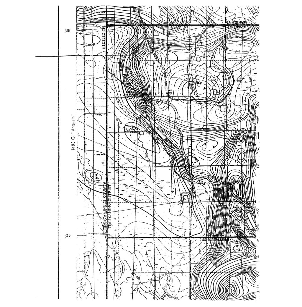
19 geology rcfcrcncccobalt RESIDENT GEO, THE TOWNSHIP OF BRETHOUR TWP. T CASEY T1 DISTR TIMISKAMING LARDER MINING LAKE DIVISION INCH To 40 CHAINS T, PATENTED CROWN LEGEND LAND LAND SALE. LICENSE OF OCCUPATION POWER TRANSMISSION LINE ROADS L.O. /V/v/vc Rr&f/rs ONLY SURFACE: RIGHTS H RO S Ro C o: ul J O uj (D U D O LJ O Z > o ct CL MINING LANDS BRANCH NOTES 40O' Surfaca nqht re5ervation around all lake* and rivers Q 00 m DATE OF ISSUE NOV O 1995 LARDER LAKE l l II ARCHIVED UNC. ^ ARCHIVED JULY 26/95 HARRIS TWR 4 ONTARIO THE INFORMATION THAT APPEARS ON THIS MAP HAS BEEN COMPILED FROM VARIOUS SOURCES, AND ACCURACY IS NOT GUARANTEED THOSE WISHING TO STAKE MIN ING CLAIMS SHOULD CON SULT WITH THE MINING RECORDER, MINISTRY OF NORTHERN DEVELOP MENT AND MINES, FOR AD PITIONAL INFORMATION ON THE STATUS OF THE LANDS SHOWN HEREON MINISTRY OF NATURAL RESOURCES 31M12NE CASEY 200 SURVEYS AND MAPPING BRANCH
20 DRILL HOLE F '150E 1200E 1250E 1300E 1350F 1400E ECEIVED i JAN CONSOLIDATED PINE CHANNEL MAGNETIC SURVEY POSTINGS CASEY TWP. ONTARIO/QUEBEC CLAIM(S) TRUMENT GSM l'j MA(.NFTOMETER DATE DRAWN BY PROTECH DRAPING SERVICES IARONGE, SASK VERTICAL SCALE 1 cm50gamrnas CASE 57000Gammas GARY DUNN EXPLORATION
21 i i i 1100E 1150E 1200E 1250E 1300L 1350E 400E i i i Q 600S 700S o r r c 900S 1 OOOS 1100S 1300S 1 400S 1 500S i C lil I700S 800S 1900S 2000S 2100S S 2300S /X400S _ li 1 t y / PQ /t! 570M 5703! ; ^ uj, 5703? ( j j ] y l V " / j l j j y y y 5703/ 5W C 5704V /22 57(p2 57( t'7 570i t 5703i J 5703 i 5703 l ; 1 570: : '6 l ( 23 ( C 24 V ^ '7 M !7 570 '8 570 'fi 570 '9 570 '7 5/0'? 570^6 570^ ( 24 57) ill 53? 57( )19 57({22 W j f f b'ma/ J ST J018 5l(p E5 570C i ^ ^27 ^ f ^ ^ l j l ) y c^ f i 57043! B p 57ob , s7 STpffi (V003 5V * (C22 5^ J V : DI D i L ^^^ GOE 1150E 1200E 1250E I300E 350E 400E ^, ^ f 7 l i. ' i l lv ^ rcjnr.i f. / 57042f i > RO r S 57043/ ^ X012 57tf)3 5^ s? 5^999 ^ Q03 5/ (h (2 5703B / y 57047/ 570? JS cerine B7005 ^ ^ V006 ^013 ^ / /120 /7002 ^7008 5J016 57)19. 57)20 53)17. *ew 57)19 37)18 57)18 57)18 57(122 57(122 57(24 57( S S 570J1 570:9 57C24. 57C '8 570: o 57o;o 57C/25 5/0 1 4 V / ) y y i ri 5/064 j LI I J [7 f ' ^ 7^ r i Nix i ^ r^1 fc i l J X Q/ 570K) & s 5/ / 57042^ 57oVl 5/034 5/ l i / ,, 57(43, fv V , ) j 5/064 (, 5/ S V 57080, / l 57058, l y 5704, 3/ 570/W " B7001 5) V /oL/ 5mm '5/OM l y 57042/ 570/6 5703?j /5 5 //'O 5' '013 5" '01 3 5/ E.7Q '' ^ B )21 57)19 5/119 57( '8 570:7 5 /O '7 570: ) 5703k 5703) ( J7011 i OOS l 700S 800S 900S 00 CIS ia?j y 1 1/OOS ' J l y l 200S S 1 400S l S,oos y S 1 700S 1800S D, 9Ja TT S S 2200S S 2400S j DRILL g RECEIVED ft JAN MINING LANDS BRANCH 31M12NE CASEY 220 CONSOLIDATED PINE CHANNEL MAGNETIC SURVEY POSTINGS CASEY TWP. ONTARIO/QUEBEC CLAIM(S) , , INSIKUMENF i^m 19 MAGNETOMETER DAFF DRAWN B~Y PROTECH DRAPING '..[.PVICET, LARONGL, SASh VERTICAL 'VALE 1 cm ^Gammas L:AGL S/OOOGammas D/J/V/V EXPLORATION
22 11 GOE 1150E 1200P 1250E 1300E 1350E 1400E i DRILL HOLE g RECEIVED JAN DOE 1150E I200E 1250L 1300L MINING LANDS BRANCH CONSOLIDATED PINE CHANNEL MAGNETIC SURVEY CONTOURS CASEY TWP. ONTARIO/QUEBEC CLAIM(S) , , INSTRUMENT GSM 19 MAGNETOMETER DATE DRAWN BH PROTEChl DRAPING SERVICES EARONGE, SASK GARY DUNN EXPLORATION
RECEIVED. for Sharpmin Developments Incorporated FEB Geologist January 4, 1996 Toronto, Ontario MINING LANDS BRANCH
 31F06NE0001 2 164OO SEBASTOPOL 010 Analytical Results for Apatite Samples from Turner's Island, Island 'D', Mining Claim SO 1150877, Sebastopol Township, Renfrew County, Southern Ontario Mining Division
SELCO EXPLORATION COMPANY LIMITED
 --..-..-...-.....l.iibibiiiiiiiiiiiiiii II III S2J16NW9001 52J16NW0014A1 PASHKOKOGAM LAKE 0 10 SELCO EXPLORATION COMPANY LIMITED GEOPHYSICAL REPORT CLAIMS 200696 TO 200707 PATRICIA MINING DIVISION August
Within. Mineral Claim
 31E12SE2001 2.19268 RYERSON 010 2.19-68 January 15,1999 ASSESSMENT REPORT ON A GEOLOGICAL MAPPING PROJECT Within Mineral Claim 1077246 Ryerson Township, Southern Ontario TABLE OF CONTENTS 1. Summary And
XRAL X-RAY Bharti Engineering Associates Inc Lasalle Blvd. P O Box 2336 Sudbury (M P3A4S8. DATE SUBMITTED 9-Aug-89
 XRAL X-RAY 1885 LESLIE S TEL: (416)445 41113SE9429 2.12731 ULSTER 010 C ERT X F X O A.T E TO: BHARTI ENGINEERING ASSOCIATES INC. ATTN: HAROLD J. TRACANELLI 1009 LASALLE BLVD P.O. BOX 2336 SUDBURY, ONTARIO
31L11NW MCAUSLAN 010 A REPORT ON A RECONNAISANCE GEOLOGY SURVEY PROJECT
 31L11NW9557 2.15064 MCAUSLAN 010 2. 15064 A REPORT ON A RECONNAISANCE GEOLOGY SURVEY PROJECT IN MCAUSLAN TOWNSHIP, ONTARIO FOR CENTRAL ONTARIO NATURAL STONE COMPANY LIMITED,o RECEIVED JUN l 5 1993 MINING
Toronto, Ontario November 16, This report may not be reproduced, in whole or in part, without the written permission of Derry, Michener S Booth.
 13 2.1354 L ITTLE 010 GEOPHYSICAL SURVEYS, LITTLE TOWNSHIP CLAIM GROUP OB-F TIMMINS AREA PORCUPINE MINING DIVISION, ONTARIO Toronto, Ontario November 16, 1973 This report may not be reproduced, in whole
Assessment Report by the Canadian Nickel Co. Ltd. Magnetometer Survey. Larder Lake Mining Division Lebel Tovnship, Ontario
 32084Nwea67 2.331* LEBEL 010 Assessment Report by the Canadian Nickel Co. Ltd. Magnetometer Survey Larder Lake Mining Division Lebel Tovnship, Ontario Claims L-531657 L-531658 L-531111 Map No.: M-359,
Magnetometer Survey on the
 42E13NE8400 2.15192 CASTLEWOOD LAKE 010 Magnetometer Survey on the FOUNDER RESOURCES INC. Conglomerate Lake Property Castlewood Area/ Ontario District of Thunder Bay Oct. 15, 1993 By: Barbara Kowalski
42AeSNEeSe GODFREY ASSESSMENT WORK FOR RICHARD MATHIEU ON THE GODFREY TOWNSHIP PROPERTY TIMMINS, ONTARIO RECEIVED MINING LANDS BRANCH
 42AeSNEeSe7 2.14685 GODFREY 010 ASSESSMENT WORK FOR RICHARD MATHIEU ON THE GODFREY TOWNSHIP PROPERTY TIMMINS, ONTARIO RECEIVED AUG13 1992 MINING LANDS BRANCH PROSPECTING WORK (a) CLAIM LOCATION Area:...
1 CLAIMS GEOPHYSICAL REPORT ON BOYAL SITUATE NORTHEAST OF TILLICUM MOUNTAIN GOLD AREA BURTON - NAKUSP SIQCAEJ MINING DIVISION
 GEOPHYSICAL REPORT ON BOYAL 1 CLAIMS SITUATE NORTHEAST OF TILLICUM MOUNTAIN GOLD AREA BURTON - NAKUSP SIQCAEJ MINING DIVISION CONSULTING GEOLOGIST AUGUST 1983 VANCOUVER B *C INDEX INTRODUCTION ooa,.eoaaa.aaaoaaooaoa~ao~o
. QOtSI. Timmins Area. Geological Report NE Eldorodo Township Property. June, 1994 D R. 42A06SE M93E DORADO "" 010
 . QOtSI 42A06SE00462 1M93E DORADO "" 010 Geological Report NE Eldorodo Township Property Timmins Area June, 1994 D R. mile Langmuir Tp. - M.292 Geological Report NE Eldorodo Township Property Timmins Area
We are committed to providing accessible customer service. If you need accessible formats or communications supports, please contact us.
 We are committed to providing accessible customer service. If you need accessible formats or communications supports, please contact us. Nous tenons à améliorer l accessibilité des services à la clientèle.
Report of Gridding and Magnetic Surveys. On the. Munro Property. Munro and Beatty Townships, Ontario. Larder Lake Mining Division
 Report of Gridding and Magnetic Surveys On the Munro Property Munro and Beatty Townships, Ontario Larder Lake Mining Division Claims: 39 4244 For Big Red Diamond Corporation October 3, 2 Timmins, Ontario
2. i. GEOLOGY Vincent Twp., Ontario NTS 42E/12. By: Barbara Kowalski FOUNDER RESOURCES INC. 42E12NE VINCENT
 42E12NE0062 2.15658 VINCENT 010 2. i FOUNDER RESOURCES INC. GEOLOGY Vincent Twp., Ontario NTS 42E/12 September 21, 1994 By: Barbara Kowalski 42E12NE0062 2.15658 VINCENT 010C TABLE OF CONTENTS TITLE PAGE
John A. Wakeford Noranda Exploration Co., Ltd, November 4, 1980 rinnnins, Ontario
 42CC1NEfc4e9 801101 ECHUM 010 " ' i-^y&sg?' '.. -.r. K;VW\\:.!^-*.]-^--'^-r-r^Pj^Q..-. ;,: v 1,;-'-,..- ^^-^^^^ysr-r^ijjfiv^jj. v -." ". '. ' "i - '' '. '':.;': s.'.ilv'., p...--'*l r-j@tw IP ^vt'.'v*:-^
Newmont Exploration of Canada Limited Box 105 Commerce Court West, Toronto, Ontario MSL 1E3
 41PI5NE8341 3.3338 CAIRO 010 GEOPHYSICAL SURVEY REPORT MAGNETOMETER SURVEY CAIRO PROJECT CAIRO TOWNSHIP - NTS: 41 P/15 by Newmont Exploration of Canada Limited Box 105 Commerce Court West, Toronto, Ontario
DOMINION GULF COMPANY 203 BAY STREET TORONTO l, ONTARIO, CANADA
 31M12SE8ai2 6 3.281 CASEY DOMINION GULF COMPANY 203 BAY STREET TORONTO l, ONTARIO, CANADA 010 E. W. WE8TRICK GENERAL AOENT IN REPLY REFER TO: February l, 1952. REGISTERED Mr. H. C. Rickaby, Deputy Minister
BLACK PEARL MINERALS INC.
 52F07SE0008 2.16968 MEGGISI LAKE 010 BLACK PEARL MINERALS INC. GEOPHYSICAL SURVEYS «SUNSHINE LAKE PROPERTY» Octobre 1996 «* TABLE OF CONTENTS I - INTRODUCTION P. 1 II - PROPERTY P. 1 III - LOCATION & ACCESSIBILITY
31M05SE LORRAIN 010
 LATOLIR LAKE VLF SURVEY 31M05SE0003 2.4460 LORRAIN 010 The EM-16 survey program on the Latour Lake Property located in Lorrain Township, District of Temiskaming, Sudbury Mining Division has been extended
7 MILES WEST OF PORT HARDY, B.C.
 GEOPHYSICAL REPORT VERTICAL INTENSITY MAGNETOMEER SURVEY ON LUK CLAIMS, 7 MILES WEST OF PORT HARDY, B.C. 50' 127O SE BY R. E. SHIELDS UNDER SUPERVISION OF J. R. BILLINGSLEY FOR SECOND0 MINING LTD. (N.
COMINCO LTD. HORIZONTAL LOOP EM AND MAGNETIC SURVEYS ON SHA. CLAIMS 1, 2, 7 and 8 NELSON AND FORT STEELE MINING DIVISIONS, B.C.
 COMINCO LTD. EXPLORATION WESTERN DISTRICT NTS: 82-F/1 HORIZONTAL LOOP EM AND MAGNETIC SURVEYS ON SHA CLAIMS 1, 2, 7 and 8 - ASSESSMENT REPORT - NELSON AND FORT STEELE MINING DIVISIONS, B.C. Latitude Longitude
magnetic and electromagnetic survey carried out to locate on the ground an aeromagnetic zone and associated In-put anomalies indi
 42IICWMW 63.2293 FLINCH LAKE O1O 6 3- Z* The President and Directors, Consolidated Manitoba Mines Limited. 114 East 90th Street. New York City 10028. New York. U. S. A. Gentlemen: This report describes
REPORT ON MAGNETOMETER SURVEY TIK-1 CLAIM e&f KAMLOOPS MINING DTVISION. by D. Hendry D. C. MILLER. February 3, for
 REPORT ON MAGNETOMETER SURVEY TIK-1 CLAIM 92-1-14 e&f KAMLOOPS MINING DTVISION lat. 50 57 ' 12" long. 121O23 ' 37" OWNER: ST. JOSEPH EXPLORATIONS LIMITED OPERATIOR: ST. JOSEPH EXPLORATIONS LIMITED by D.
Ground Magnetometer Survey Claim Bucke Twp Larder Lake Mining Division Ontario
 010 Ground Magnetometer Survey Claim 1118540 Bucke Twp Larder Lake Mining Division Ontario for Consolidated Pine Channel Gold Corp #921-470GranvilleSt Vancouver British Columbia by Gary Dunn Exploration
PHOENIX GEOPHYSICS LIMITED REPORT ON THE VLF-EM AND TOTAL FIELD MAGNETOMETER SURVEYS ON THE
 PHOENIX GEOPHYSICS LIMITED REPORT ON THE VLF-EM AND TOTAL FIELD MAGNETOMETER SURVEYS ON THE TAN CLAIMS, CHILLIWACK AREA NEW WESTMINSTER MINING DIVISION, BRITISH COLUMBIA FOR LORNEX MINING CORPORATION LIMITED
fe JAMES LAKE PROPERTY BEST TWP. HORIZONTAL LOOP ELECTROMAGNETICS GEOPHYSICAL SURVEY by: David Laronde 31M04NE001S BEST
 fe. 15449 31M04NE001S 2 15449 BEST 010 JAMES LAKE PROPERTY BEST TWP. HORIZONTAL LOOP ELECTROMAGNETICS GEOPHYSICAL SURVEY FEBRUARY 1994 by: David Laronde HUH 01OC Table of Contents 1.0 Introduction 2.0
REPORT ON GEOLOGICAL MAPPING OF CLAIM SHAW TOWNSHIP PORCUPINE MINING DIVISION) NORTHEASTERN ONTARIO FOR LAURION GOLD INCORPORATED
 NORTHEASTERN ONTARIO FOR LAURION GOLD INCORPORATED") REPORT ON GEOLOGICAL MAPPING OF CLAIM 1180899 SHAW TOWNSHIP PORCUPINE MINING DIVISION) NORTHEASTERN ONTARIO * O Q Q fi FOR LAURION GOLD INCORPORATED Schumacher, ON November 29th, 2004 Leslie A. Tihor Tihor
REPORT ON GEOLOGICAL MAPPING OF CLAIM 1180899 SHAW TOWNSHIP PORCUPINE MINING DIVISION) NORTHEASTERN ONTARIO * O Q Q fi FOR LAURION GOLD INCORPORATED Schumacher, ON November 29th, 2004 Leslie A. Tihor Tihor
SUPPLEMENT TO MAGNETOMETER 6 ELECTROMAGNETIC SURVEY REPORT. DATED NOVEMBER l, 1973 CIGLEN INVESTMENTS LIMITED CLAIMS GROUP BAD VERMILLION LAKE AREA
 ^ A R l ^ 1974 010 PROJECTS UNIT SUPPLEMENT TO MAGNETOMETER 6 ELECTROMAGNETIC SURVEY REPORT DATED NOVEMBER l, 1973 CIGLEN INVESTMENTS LIMITED CLAIMS GROUP BAD VERMILLION LAKE AREA DISTRICT OF RAINY RIVER
RECEIVED MINING LANDS SECTION. a.9535 MCTAVISH. E.A. JENNINGS, H.D.Se. Thunder Bay, Ontario September GEOLOGY OF THE THUNDER BAY AMETHYST MINE
 a.9535 MCTAVISH 010 GEOLOGY OF THE THUNDER BAY AMETHYST MINE AND PRECIOUS PURPLE GEMSTOHES CLAIMS E.A. JENNINGS, H.D.Se. Thunder Bay, Ontario September 30 1985 RECEIVED MOV l o 1986 MINING LANDS SECTION
Ontario. Strathy Township Temagami Area Sudbury Mining Division. Driffield Cameron GROUND ELECTROMAGNETIC SURVEY PENROSE NORTH PROPERTY.
 l J1MO4SW0153 2 16336 STRATHY 010 GROUND ELECTROMAGNETIC SURVEY PENROSE NORTH PROPERTY Strathy Township Temagami Area Sudbury Mining Division Ontario Driffield Cameron January 5, 1996 r*, t 31MCWSW01S3
We are committed to providing accessible customer service. If you need accessible formats or communications supports, please contact us.
 We are committed to providing accessible customer service. If you need accessible formats or communications supports, please contact us. Nous tenons à améliorer l accessibilité des services à la clientèle.
PIOTR LUTYNSKI VANCOUVER, BRITISH COLUMBIA
 AN ASSESSMENT REPORT ON GROUND MAGNETIC SURVEYING CHUCHI PROPERTY FORT ST. JAMES AREA, BRITISH COLUMBIA OMINECA M.D. 55 17 N, 124 31 W NTS 93N/ 7&8 Claims Surveyed: 597976, 597878-597880 Survey Dates:
NTS 93L/9W GEOCHEMICAL AND GEOPHYSICAL REPORT MONA CLAIM OMINICA MINING DIVISION. Lati tude 54036'N; Longitude 'W
 GEOCHEMICAL AND GEOPHYSICAL REPORT ON MONA CLAIM OMINICA MINING DIVISION Lati tude 54036'N; Longitude 126018'W NTS 93L/9W April 1981 Paul Plicka Consulting Geologist LOCATION MAP INTRODUCTION TABLE OF
RECEIVED. tn r-"t."' Magnetometer and VLF-EM Surveys Assessment Report. South Cobalt Silver Project South Lorrain Twp. Mhakari Gold Corp.
 RECEVED APR 1 5 111 OOSC!C! AESSMET tn r-"t. Magnetometer and VLF-EM Surveys Assessment Report South Cobalt Silver Project South Lorrain Twp. Mhakari Gold Corp. March 211 TS 31 M/3-4 Meegwich Consultants
Post. Claim E.O D.D.Hole \ L ength 243' Bearing N.52 U W, Dip 45 0 AXT core BIJOU MINFS LIMITED. l" to 100' 31C15NW PALMERSTON 010
 #1 Post Claim E.O. 460392 D.D.Hole \ L ength 243' Bearing N.52 U W, Dip 45 0 AXT core BIJOU MINFS LIMITED l" to 100' September 22, 1977 J. P. Jewell 31C15NW0019 74 PALMERSTON 010 DIAMOND DRILL RECORD PROPERTY
ZENMAC METAi, MINES LIMITED. SCHHKIBEK, ONTnHlO. PURVEY OK THE NI'COPOR PROPERTY
 63.2625 PAYS PLAT LAKE 010 ZENMAC METAi, MINES LIMITED SCHHKIBEK, ONTnHlO. PURVEY OK THE NI'COPOR PROPERTY IS'iRODUCTIQM The property, about 6 miles north of Schreiber, has been held by various people
DDH MS Over burden 42EioNwooiow944o.ooi56ASHMORE ' qtz. carovein aampj.c nu. j. ^ Altered Dacite j
 s J Hole depth 156 Hole dip -45 DDH MS-90-2 Maw OT 1 QQfl 0-8 Over burden 42EioNwooiow944o.ooi56ASHMORE 010 8-8.8.8' qtz. carovein aampj.c nu. j. ^ 8-62.5 Altered Dacite j 11.8-12.2.4' qtz. carb along
ASSESSMENT SUMMARY - A. SALO PROPERTY ( MCGARRY TOWNSHIP ^ NTS 32D/4. Introduction
 2. 16102 ASSESSMENT SUMMARY - A. SALO PROPERTY ( MCGARRY TOWNSHIP ^ NTS 32D/4 Introduction On May 25, 1995, Falconbridge geologist Ray Kohlsmith visited staked claims 1 187016 A 1 187017 located 500m north
Total Magnetic Field and VLF Surveys on the Swayze Property. Claim Swayze Township. Porcupine Mining Division
 1 January, 016 NTS: 041 O 15 Total Magnetic Field and VLF Surveys on the Swayze Property Claim 475471 Swayze Township Porcupine Mining Division 380850E, 599450N UTM Z17N NAD83 Report Prepared for: 540
* STUART W. DEVEAU. r '/i SEPTEMBER 1995 NTS: 52K/13 PLACER DOME CANADA LIMITED PROJECT CLAIM KRL
 S2K13NW0011 2 16217 BAIRD 010 PLACER DOME CANADA LIMITED PROJECT 413 - CLAIM KRL 1184166 GEOLOGICAL REPORT - 1995 WORK PROGRAMME BAIRD TOWNSHIP, ONTARIO NTS: 52K/13 r '/i SEPTEMBER 1995 * STUART W. DEVEAU
We are committed to providing accessible customer service. If you need accessible formats or communications supports, please contact us.
 We are committed to providing accessible customer service. If you need accessible formats or communications supports, please contact us. Nous tenons à améliorer l accessibilité des services à la clientèle.
WORK REPORT. on the ALEXO PROPERTY DUNDONALD TOWNSHIP PORCUPINE MINING DIVISION. for LIBERTY MINES INC.
 GEOSCIE CE AS r::;ss lent OFFICE WORK REPORT on the ALEXO PROPERTY DUNDONALD TOWNSHIP PORCUPINE MINING DIVISION for LIBERTY MINES INC. 2. 340 51 Submitted by: Steve Anderson VISION EXPLORATION 2041663
BALFOUR MINING LTD. (N.P.L.) HAM GROUP 92-P-6, CLINTON M. D.8 B. C. Lat 51 17'N, GEOCHEMICAL REPORT. V. CUKOR, P. Eng.
 HAM GROUP 92-P-6, CLINTON M. D.8 B. C. Lat 51 17'N, GEOCHEMICAL REPORT. V. CUKOR, P. Eng.") 34q '7 BALFOUR MINING LTD. (N.P.L.) HAM GROUP 92-P-6, CLINTON M. D.8 B. C. Lat 51 17'N, Long 12lo14'W GEOCHEMICAL REPORT, V. CUKOR, P. Eng. January 31, 1972 TABLE OF CONTENTS 1. INTRODUCTION 2. PROPERTY,
34q '7 BALFOUR MINING LTD. (N.P.L.) HAM GROUP 92-P-6, CLINTON M. D.8 B. C. Lat 51 17'N, Long 12lo14'W GEOCHEMICAL REPORT, V. CUKOR, P. Eng. January 31, 1972 TABLE OF CONTENTS 1. INTRODUCTION 2. PROPERTY,
REPORT OF MAGNETOMETER SURVEY ON TB RICKABY 8 LAPIERRE TOWNSHIPS THUNDER BAY MINING DIVISION THUNDER BAY, ONTARIO RECEIVED
 42E14SW0017 2.15545 LAPIERRE LAKE 010 REPORT OF MAGNETOMETER SURVEY ON TB1196017 RICKABY 8 LAPIERRE TOWNSHIPS THUNDER BAY MINING DIVISION THUNDER BAY, ONTARIO 2.15545 RECEIVED AUG 2 9 1994 ' MINING UkNDS
RECEIVED. May ^6 Kirkland Lake, Ont MINING LANDS SECTION ASSESSMENT REPORT MAGNETOMETER SURVEY CLAIM //842970
 42Aeiseeeie a.9ts4 TECK 010 ASSESSMENT REPORT MAGNETOMETER SURVEY CLAIM //842970 TWP. of TECK LARDER LAKE MINING DIVISION FOR LAC MINERALS (MACAS3A DIVISION) by JOMI MINERALS ft EXPEDITING LTD. May 15
We are committed to providing accessible customer service. If you need accessible formats or communications supports, please contact us.
 We are committed to providing accessible customer service. If you need accessible formats or communications supports, please contact us. Nous tenons à améliorer l accessibilité des services à la clientèle.
DIAMOND DRILLING NOTES: 1. W , filed July 19/93. TWyARKA Scapa REPORT NO. WORK 1'KUKOIIMKD l.\)i^oranda Ex P loration Co - Ltd -
i^oranda Ex P loration Co - Ltd -") 3aE04SW934B l SCAPA 00 DIAMOND DRIING TWyARKA Scapa REPORT NO. WORK 'KUKOIIMKD l.\)i^oranda Ex P loration Co - td - RKOORDKn HOUWIl: SAME AS ABOVE f X l : OTHER! j CIAIM NO. 590 HOK NO. SC-90- FOOTAGE
3aE04SW934B l SCAPA 00 DIAMOND DRIING TWyARKA Scapa REPORT NO. WORK 'KUKOIIMKD l.\)i^oranda Ex P loration Co - td - RKOORDKn HOUWIl: SAME AS ABOVE f X l : OTHER! j CIAIM NO. 590 HOK NO. SC-90- FOOTAGE
Simplified exploration work report
 Simplified exploration work report Work Report of exploration and examination of outcrops of rock and boulders Report on stripping and excavating work of $ 5 000 or less.(section 81 of regulation) Report
PROSPECTING REPORT THE WALLACE CLAIM OMENICA MINING DIVISION. 54" x6" 3.d d. for. Reako Exlorat ions Ltd. Wallace Rev. C.G.
 PROSPECTING REPORT ON THE WALLACE CLAIM OMENICA MINING DIVISION 54"44 14 1x6" 3.d d by David A. Howard P.Eng. for Reako Exlorat ions Ltd. Claim Locat ion Wallace Rev. C.G. #1560 Dome Mountain Area 9 3
Lost nine Property Assessment Work Report Van Horne Township ( Kenora Mining Division
 52F10NW2001 2.20035 VAN HORNE 010 Lost nine Property Assessment Work Report Van Horne Township ( Kenora Mining Division Wm. J. Sovereign 103 Wabigoon Drive Dryden, Ontario P8N 1W4 January 22, 2000 TABLE
42H88SW NEWMAN
 42H88SW0003 63.8199 NEWMAN 010 TRIPOINT MINES LIMITED, Suite 305-100 Adelaide St. West, Toronto l, Ontario. Gentlemen: Your Company recently conducted a combined magneticelectromagnetic survey over a ten
No other previoro work recorded on the area covered
 PROSPECTING REPORT FISHER LAKE AREA #62617 KENORA MINING DIVISION NTS52F12SE LAT. 49 34'45" to 49 35 i 45 lt north LONG. 93 30'30" to 9 3 31'45" WEST INTRODUCTION Claimsl149639-40-41-42 vere staked to
Magnetic Field and VLF Surveys on the Shining Tree Property. Claims: , , , , , , , ,
 December 29, 2014 NTS: 041P11 Magnetic Field and VLF Surveys on the Shining Tree Property Claims: 1203361, 4251801, 4251803, 4251805, 4263067, 4263068, 4270940, 4270436, 4276740 Churchill and Asquith Townships
WAONEK-MILLS JPHVSiCAL SURVEYS
 xxxxxx L. i* ^- O PHONE HO, C - 7526 XXXXXXX) WAONEK-MILLS JPHVSiCAL SURVEYS XXXXXAAA SUITE 401, 62 RICHMOND ST. WEST 15 MEREDITH. IEREDITH. C RESCENT TOR.ONTO. TORONTO, CANADA till6ne0082 0815C1 SCHOLES
MAGNETOMETER SURVEY Frere Lake Property Hudson Township Harley Walton August 1997
 MAGNETOMETER SURVEY Frere Lake Property Hudson Township Harley Walton August 1997 E c RECEIVED SEP 1 8 1997! 31M12SW0025 2.17740 HUDSON 010 ieoscience ASSESSMENT Meegwich Consultants Inc. P.O. Box 482,
4. Geological maps published by the Ontario Department of Mines.
 52J08NWei45 S2J08NWa6B1 SMYE 010 AMALGAMATED RARE EARTH MINES LTD. *, SAVANT LAKE PROSPECT x ONTARIO INTRODUCTION t This Is a report on a group of 28 claims control led by Amalgamated Rare Earth Mines
CONSULTING GEOLOGICAL 8: MINING ENGINEERS STINGS STREET DA V6E 2E9 GEOPHYSICAL SURVEY SILVER QUEEN 2 ZEBALLOS AREA. B.C.
 DOLMAGE CAMPBELL & ASSOCIATES (1 975) LTD. CONSULTING GEOLOGICAL 8: MINING ENGINEERS STINGS STREET DA V6E 2E9 '' 1E O L 0 G I C A.L B'x;&a:f2:#& 'SESSMENT REPObT 12, Assessment RESOURCES LTD. 111 ReDort
We are committed to providing accessible customer service. If you need accessible formats or communications supports, please contact us.
 We are committed to providing accessible customer service. If you need accessible formats or communications supports, please contact us. Nous tenons à améliorer l accessibilité des services à la clientèle.
B.C. Vancouver, Sritish Columbia. Ragas Claims, Omenica M.D., A GEOPHYSICAL REPORT. A GROUKD NAGMETIC 6: ELECTRO?.IAGr\TETIC SURVEY FOR
 A GEOPHYSICAL REPORT A GROUKD NAGMETIC 6: ELECTRO?.IAGr\TETIC SURVEY Ragas Claims, Omenica M.D., B.C. FOR CATRE - 3EK JOINT VENTURE PETER E. WALCOTT & ASSOC. LIPIITED Vancouver, Sritish Columbia OCTOEEEt
RECEIVED JUL MINING LANDS SECTIOM KATRINE TOWNSHIP, ONTARIO LARDER LAKE MINING DIVISION NTS 32 D A REPORT ON
 3aDMSEM4S S.9349 KATRINE 010 GRID KA 8 KATRINE TOWNSHIP, ONTARIO LARDER LAKE MINING DIVISION NTS 32 D A REPORT ON MAGNETIC SURVEY RECEIVED JUL 11 1986 MINING LANDS SECTIOM A. JAMES WALKER P.Eng. JUNE 18,
t y RECEIVED This report is concerned with the results of the electromagnetic survey as applied to the following claims: l K to K
 t y 53F*4NWei37 2.1853 HERONRY LAKE 010 HUDSON BAY EXPLORATION AND DEVELOPMENT COMPANY LIMITED ELECTROMAGNETIC SURVEY OF GROUP "N" EAGLE PROJECT - KAKAGI BLOCK KENORA MINING DIVISION - ONTARIO RECEIVED
PHYSICAL WORK REPORT. the BAY CLAIMS. Omineca Mining Division Smithers, British Columbia N.T.S. 93E 13E/W
 PHYSICAL WORK REPORT the BAY CLAIMS Omineca Mining Division Smithers, British Columbia a N.T.S. 93E 13E/W LATITUDE: 53 57 00 N I LONGITUDE: 127 45 OO W for Home Ventures Ltd. 1201-675 West Hastings Street
Geneva Lake Mine Property
 2 "-,." j, i.. \' i Fli FR l- ' 2 "- ''. -" ^tji. o -^' " - - - S? l GEOSCIENCE ASSESSMENT Reconnaissance" Prospecting and Geological Surveys on the j Geneva Lake Mine Property Hess TOWNSHIP Zn-Pb-Cu-Ag
Prospecting Program on Mining Claim L , Bernhardt Township, Larder Lake Mining Division in the District of Timiskaming.
 Prospecting Program on Mining Claim L -1199563, Bernhardt Township, Larder Lake Mining Division in the District of Timiskaming. Table of Contents Pase Claim Map Geological Map Introduction Location & Access
OEOMAQNETIC SURVEI QUIBORD TOWNSHIP GROUP #2 HOLLINGER CONSOLIDATED GOLD MINES, LTD.
 OEOMAQNETIC SURVEI QUIBORD TOWNSHIP GROUP #2 HOLLINGER CONSOLIDATED GOLD MINES, LTD. 42Ae9SE0268 63.1502 GUIBORD (711(71 Introduction During the period January 5 - February 26, 1965, a magnetometer survey
REPORT OF MAGNETIC SURVEY WADSWORTH LAKE PROPERTY BRITS*; C. ROBSON
 31C13SE8833 63.567 010 REPORT OF MAGNETIC SURVEY on WADSWORTH LAKE PROPERTY BRITS*; C. ROBSON - 2 - INTRODUCTION The Wadsworth Lake Property, in 1916, had had test pitting and trenching done on it in a
GEOPHYSICAL REPORT CHU CHUA PROJECT Green Mountain Group. KAMLOOPS MINING DIVISION NTS 92P/8E, 82M/5W Lat: 51'24' N Long: 120'00' w
 I GEOPHYSICAL REPORT CHU CHUA PROJECT Green Mountain Group KAMLOOPS MINING DIVISION NTS 92P/8E, 82M/5W Lat: 51'24' N Long: 120'00' w I rvm #.,_..._..._._._.- $...-...! 1 VANCOUVER, B.C. 1 G E 0 I, 0.G
Report of Geology Vimy Ridge Project Four Mining Claims, N^ of Lot 6, Concession III Bowman Township Ontario
 42A88NWai04 2.5281 BOWMAN 010 Report of Geology Vimy Ridge Project Four Mining Claims, N^ of Lot 6, Concession III Bowman Township Ontario Asarco Exploration Company of Canada Limited Alex S. Horvath December
r ffj Ronald C. Wells, BSc. Lacana Mining Corporation LACANA CLAIMS GAUTMER TOWNSMP GEOPHYSICAL REPORT OCT LARDER LAKE MINING DIVISION
 a- 32D04NWei39 2.3507 GAUTHIER 010 GEOPHYSICAL REPORT LACANA CLAIMS GAUTMER TOWNSMP LARDER LAKE MINING DIVISION RECEIVED OCT171980 MINING UNDS SECTION Author: Ronald C. Wells, BSc. Lacana Mining Corporation
SUMMARY REPORT. RE-ESTABLISH CLAIM BOUNDARY (Claim ) CARR TOWNSHIP (Larder Lake Mining Division) NTS (42 Al09) FOR
 CARR TOWNSHIP (Larder Lake Mining Division) NTS (42 Al09) FOR") 2.44330 " SUMMARY REPORT RE-ESTABLISH CLAIM BOUNDARY (Claim 3002288) CARR TOWNSHIP (Larder Lake Mining Division) NTS (42 Al09) FOR ST ANDREW GOLDFIELDS LTD. ""'1,.I Les 1. Kovacs, P. Geo For: St Andrew
2.44330 " SUMMARY REPORT RE-ESTABLISH CLAIM BOUNDARY (Claim 3002288) CARR TOWNSHIP (Larder Lake Mining Division) NTS (42 Al09) FOR ST ANDREW GOLDFIELDS LTD. ""'1,.I Les 1. Kovacs, P. Geo For: St Andrew
John C. Grant sias Exploration Limited. Timmins, Ontario June, 1983 REPORT O N MAGNETOMETER SURVEY CHURCHILL TOWNSHIP
 41P11NE8498 2.5630 CHURCHILL 010 REPORT O N MAGNETOMETER SURVEY CHURCHILL TOWNSHIP PORCUPINE MINING DIVISION NORTHEASTERN ONTARIO for GUILLAUME LEBLANC Timmins, Ontario June, 1983 John C. Grant sias Exploration
RECEIVED GOLD PROPERTY REPORT ON THE 1992 EXPLORATION OF THE LASSILA-HOUGHTON ELMHIRST TWP. MINING LANDS BRANO NTS 42E/13.
 42E13SE0603 E.14999 ELMHIRST 010 1499 REPORT ON THE 1992 EXPLORATION OF THE LASSILA-HOUGHTON ELMHIRST TWP. GOLD PROPERTY NTS 42E/13 Latitude 490 50* Longitude 870 21' Date: December 1992 By: P. Lassila
Rubicon Minerals Corporation. Physical Work Submission Report June, RED LAKE PROPERTY MECHANICAL STRIPPING South Pipestone Bay
 Rubicon Minerals Corporation Physical Work Submission Report June, 2001 RED LAKE PROPERTY MECHANICAL STRIPPING South Pipestone Bay Ball Township Red Lake Mining Division NTS 52/N4 2.216 A /^ r--^'^-, t'n
52AieNE8iei MCTAVISH
 C 52AieNE8iei 63.6201 MCTAVISH 010 r - A. rf T able of Contents 52AiaiNE8lei 63.6281 MCTAVISH Introduction..............................,.......,.. 1 Location Map.........................................
REPORT ON DIAMOND DRILLING SUBSTITUTION EAST PROPERTY CLAIMS AND HEBERT TOWNSHIP ONTARIO, CANADA
 REPORT ON DIAMOND DRILLING SUBSTITUTION EAST PROPERTY CLAIMS 1248920 AND 1248921 HEBERT TOWNSHIP ONTARIO, CANADA Adroit Resources Inc. Suite #610-1111 Melville Street Vancouver, British Columbia, Canada
TIGER GOLD EXPLORATION CORPORATION. Prospecting Over the HARKER HERITAGE PROPERTY AREA 10. Harker Township, Ontario
 PO Box 219, 14579 Government Road, Larder Lake, Ontario, P0K 1L0, Canada Phone (705) 643-2345 Fax (705) 643-2191 www.cxsltd.com TIGER GOLD EXPLORATION CORPORATION Prospecting Over the HARKER HERITAGE PROPERTY
Nickel Division - Sudbury Operations
 * *-.. FALCONBRIDGE NICKEL MINES LIMITED Nickel Division - Sudbury Operations Falconbridge, Ontario 002261 GRAHAM 010 GEOLOGY OF TllE NORTH QUARTER OP LOT 2, CON. IV, GRAHAM TOWNSHIP, DISTRICT OP SUDBURY,
Drilling. What is the Activity?
 Drilling What is the Activity? Drilling is a critical activity in mineral exploration. There are several types of drilling. Diamond drilling is the most common type of drilling conducted in Ontario. It
Prospecting Report on Claim # on Bull's Eye Lake Property
 Prospecting Report on Claim #3009706 on Bull's Eye Lake Property By Eric Covington "RECEIVED OCT -7 200* GEOSCIENCE ASSESSMENT OFFICE September 27, 2004 31C07NE2001 2.28602 LOUGHBOROUGH 010 This report
THE ALGOMA STEEL CORPORATION, LIMITED GEOPHYSICAL REPORT GEONICS V.L.F. E.M.-16 ANOMALY #15 - CHABANEL TOWNSHIP SAULT STE. MARIE MINING DIVISION
 42CC2SE8880 ee^sat CHABANEL 010 THE ALGOMA STEEL CORPORATION, LIMITED RECEIVED SEP-41981 MINING LANDS SECTION GEOPHYSICAL REPORT GEONICS V.L.F. E.M.-16 ANOMALY #15 - CHABANEL TOWNSHIP SAULT STE. MARIE
Guidelines for the Form of Reports and Illustrations
 Guidelines for the Form of Reports and Illustrations as Prescribed by the Minister as per Section 55(2) of The Consolidated Newfoundland and Labrador Regulation 1143/96 (As Amended) (Revised - December,
Report on The Magnetic Survey. Property of Loydex Resources Inc. Keigat Lake Area. Red Lake Mining Division
 010 Report on The Magnetic Survey On The Property of Loydex Resources Inc. SANDY POINT PROJECT Keigat Lake Area District of Kenora, Patricia Portion Red Lake Mining Division N.T.S. 52-N-8 Whitby, Ontario
Report On. Geology Survey. Beilby Lake Property. Churchill Township, Ontario. R.A. MacGregor, P. Eng. 41P11SE CHURCHILL 010
 -23782 Report On Geology Survey Beilby ake Property Churchill Township, Ontario By R.A. MacGregor, P. Eng. June 2, 22 41P11SE242 2.23782 CHURCHI 1 Index Page Introduction l ocation, Access and Ownership
We are committed to providing accessible customer service. If you need accessible formats or communications supports, please contact us.
 We are committed to providing accessible customer service. If you need accessible formats or communications supports, please contact us. Nous tenons à améliorer l accessibilité des services à la clientèle.
Earth Sciences Report Alberta Kimberlite-Indicator Mineral Geochemical Compilation
 Earth Sciences Report 2001-20 Alberta Kimberlite-Indicator Mineral Geochemical Compilation Alberta Kimberlite-Indicator Mineral Geochemical Compilation D.R. Eccles 1, M. Dufresne 2, D. Copeland 2, W. Csanyi
1 i I.; :<7 6EOLOGICAL BRANCH ASSESSMENT REPORT HLEM, VLF-EM AND MAGNETOMETER TEST SURVEY ON THE ARC PROPERTY FOR SURVEY BY SJ GEOPHYSICS LTD.
 f - ~ --- j LOG NO: MAR 2 a 1992,,, -- - - - -- L$TiC'P;: I.; 1 i HLEM, VLF-EM AND MAGNETOMETER TEST SURVEY ON THE ARC PROPERTY FOR SURVEY BY SJ GEOPHYSICS LTD. SLOCAN M.D., B.C. N.T.S. 88 F/10 d 2- :
STURGEON BRIDGE PROPERTY. Fred Checkley Claims
 PROV.NCiA:- RECORDING OFFICE - SUDBURY RECEIVED DEC 2 3 2002 A.M. l o \ j jj *vv/}^ P.M. 7 8 9 IQ 11 I2 1 2[3 4 S 6 STURGEON BRIDGE PROPERTY Fred Checkley Claims The property lies in the north-central
To test an EM conductor and provide geological information.
 Banting Township Property OPAP Final Submission 1998 DIAMOND DRILLING REPORT January 27, 1999. Objective: To test an EM conductor and provide geological information. Final results: Two holes were drilled
g. 14 RECEIVFH NOV l MINING LANDS BRANCH REPORT ON THE EXPLORATION CARRIED OUT ON THE MOSS TOWNSHIP PROPERTY FOR FOGEN-WING-WALLACE-CALVERT
 52B18SW8101 2.14799 MOSS 010 REPORT ON THE EXPLORATION CARRIED OUT ON THE MOSS TOWNSHIP PROPERTY FOR FOGEN-WING-WALLACE-CALVERT RECEIVFH NOV l 7 1992 MINING LANDS BRANCH by: CLAUDE LAROUCHE OVALBAY GEOLOGICAL
SIXTH SCHEDULE REPUBLIC OF SOUTH SUDAN MINISTRY OF PETROLEUM, MINING THE MINING (MINERAL TITLE) REGULATIONS 2015
 REGULATIONS 2015") SIXTH SCHEDULE REPUBLIC OF SOUTH SUDAN MINISTRY OF PETROLEUM, MINING THE MINING ACT, 2012 THE MINING (MINERAL TITLE) REGULATIONS 2015 Guidelines should be prepared by the Directorate of Mineral Development
SIXTH SCHEDULE REPUBLIC OF SOUTH SUDAN MINISTRY OF PETROLEUM, MINING THE MINING ACT, 2012 THE MINING (MINERAL TITLE) REGULATIONS 2015 Guidelines should be prepared by the Directorate of Mineral Development
RECEIVED. Report on Geophysical Work. KIDD 24 PROPERTY Kidd Township NTS: 42A/11 Project # for FALCONBRIDGE LIMITED. May 1998 Sharon Taylor
 42A11NW2006 2.18507 KIDD 010 Report on Geophysical Work KIDD 24 PROPERTY Kidd Township NTS: 42A/11 Project # 8035 for FALCONBRIDGE LIMITED RECEIVED JUH O 1 1998 May 1998 Sharon Taylor SUMMARY AND RECOMMENDATIONS
010 BAND - ORE RESOURCES LTD. ROSS PROPERTY. Penhorwood Township, Ontario Porcupine Mining Division NTS: 42B/1
 42B01NE0049 2 16729 KENOGAMING 010 BAND - ORE RESOURCES LTD. ROSS PROPERTY Penhorwood Township, Ontario Porcupine Mining Division NTS: 42B/1 REPORT ON GROUND MAGNETIC SURVEYS November 30th, 1995 o ROBERT
Appendix U. Communication with Shabogamo M.E. ALDERON IRON ORE CORP.
 ALDERON IRON ORE CORP. AMENDMENT TO THE ENVIRONMENTAL IMPACT STATEMENT VOLUME 3 APPENDICES INFORMATION REQUEST RESPONSES Appendix U Communication with Shabogamo M.E. VIA EMAIL October 31,2012 Dr. Rehan
ASSESSMENT' REPORT GEOPHYSICAL REPORT ON THE ATTORNEY 2 CLAIM (4 UNITS) OMINECA MINING DIVISION SHEILA A. CRAWFORD.
 OMINECA MINING DIVISION SHEILA A. CRAWFORD.") ASSESSMENT' REPORT GEOPHYSICAL REPORT ON THE ATTORNEY 2 CLAIM (4 UNITS) OMINECA MINING DIVISION by SHEILA A. CRAWFORD LOCATION: 57z17' N Latitude 127 11' W Longitude N.T.S. 94E/6E OWNER/OPERATOR: SEREM
ASSESSMENT' REPORT GEOPHYSICAL REPORT ON THE ATTORNEY 2 CLAIM (4 UNITS) OMINECA MINING DIVISION by SHEILA A. CRAWFORD LOCATION: 57z17' N Latitude 127 11' W Longitude N.T.S. 94E/6E OWNER/OPERATOR: SEREM
PROSPECTING Survey Over the AULD PROPERTY Auld Township, Ontario
 PO Box 219, 14579 Government Road, Larder Lake, Ontario, P0K 1L0, Canada Phone (705) 643-2345 Fax (705) 643-2191 www.cxsltd.com PROSPECTING Survey Over the AULD PROPERTY C Jason Ploeger, B.Sc, P.Geo August
REPORT A MAGNETOMETER AND GEOLOGICAL SURVEY CUNNINGHAM - STALMACK PROPERTY LEBEL TOWNSHIP, ONTARIO 1991 OPAP
 I.. l 4458 32D04NWei7a 2.14458 LEBEL 010 REPORT ON A MAGNETOMETER AND GEOLOGICAL SURVEY CUNNINGHAM - STALMACK PROPERTY PERSON'S NAME LEBEL TOWNSHIP, ONTARIO bivision OR BRANCH" 1991 OPAP CITY. BUILDING.
Geo-Explorers Ltd., Noranda, Quebec. May l, 1957.
 MAGNETOMETER SURVEY CHIBOUG&MAU. MINING AND.SMELTING CO. INC. CLAY AND HOWELLS TOWNSHIPS. PROVINCE OF ONTARIO 4am3sweaai 63.3411 CLAY 010 REPORT NO. 5709 May l, 1957. Geo-Explorers Ltd., Noranda, Quebec.
NELSON GRANITE LIMITED. Test Quarrying, Sample Block Removal. Sawing and Polishing Tests. Mining Claim K-l Kilgour Lake Area NTS: 52K 4SW
 l 52K04SW2005 2.20708 KILGOUR LAKE 010 2.20708 NELSON GRANITE LIMITED Test Quarrying, Sample Block Removal Sawing and Polishing Tests Mining Claim K-l 149856 Kilgour Lake Area NTS: 52K 4SW Kenora Mining
TOWNSHIP: ARNOLD REPORT NO; 18. Date Note Nov-Dec/87 (1) Footage 266' Notes: (1) IW , filed in August/88. WORK PERFORMED FOR: LAC Minerals Ltd
 Footage 266' Notes: (1) IW , filed in August/88. WORK PERFORMED FOR: LAC Minerals Ltd") 32DMNWW2, 16 ARNOLD 010 DIAMOND DRILLING TOWNSHIP: ARNOLD REPORT NO; 18 WORK PERFORMED FOR: LAC Minerals Ltd RECORDED HOLDER: Same as Above [xx] : Other [ ] Claim No. L 884017 Hole No. A14A Footage 266'
32DMNWW2, 16 ARNOLD 010 DIAMOND DRILLING TOWNSHIP: ARNOLD REPORT NO; 18 WORK PERFORMED FOR: LAC Minerals Ltd RECORDED HOLDER: Same as Above [xx] : Other [ ] Claim No. L 884017 Hole No. A14A Footage 266'
Saroplo Interval. to to
 PQ'WER OPTION RESAPLING 2.34 EEN LAKE E-6- Sample j P 4 P 42 P 43 P 44 P 45 P 46 P 4 P 4 P 4 P 4 P 4 P 42 P 43 P 44 P 45 P 46 P 4 P 4 P 4 P 420 P 42 P 4 P 423 P 4 P 4 P 426 P 42 P 42 P 42 Saroplo Interval