REPORT OF MAGNETOMETER SURVEY ON TB RICKABY 8 LAPIERRE TOWNSHIPS THUNDER BAY MINING DIVISION THUNDER BAY, ONTARIO RECEIVED
|
|
|
- Anne McKinney
- 5 years ago
- Views:
Transcription
1 42E14SW LAPIERRE LAKE 010 REPORT OF MAGNETOMETER SURVEY ON TB RICKABY 8 LAPIERRE TOWNSHIPS THUNDER BAY MINING DIVISION THUNDER BAY, ONTARIO RECEIVED AUG ' MINING UkNDS l I/I I'l ill l l 11 Illllllll ES R, B. PARRES. Se. ADV. GEOLOGY JULY 25, 1991
2 42E14SW LAPIERRE LAKE 01OC INDEX INTRODUCTION LOCATION ACCESS HISTORY GEOLOGY MAG SURVEY t GENERAL INSTRUMENTATION 8 PARAMETERS MAG GENERAL RESULTS CONCLUSIONS RECOMMENDATIONS PAGE No, l l
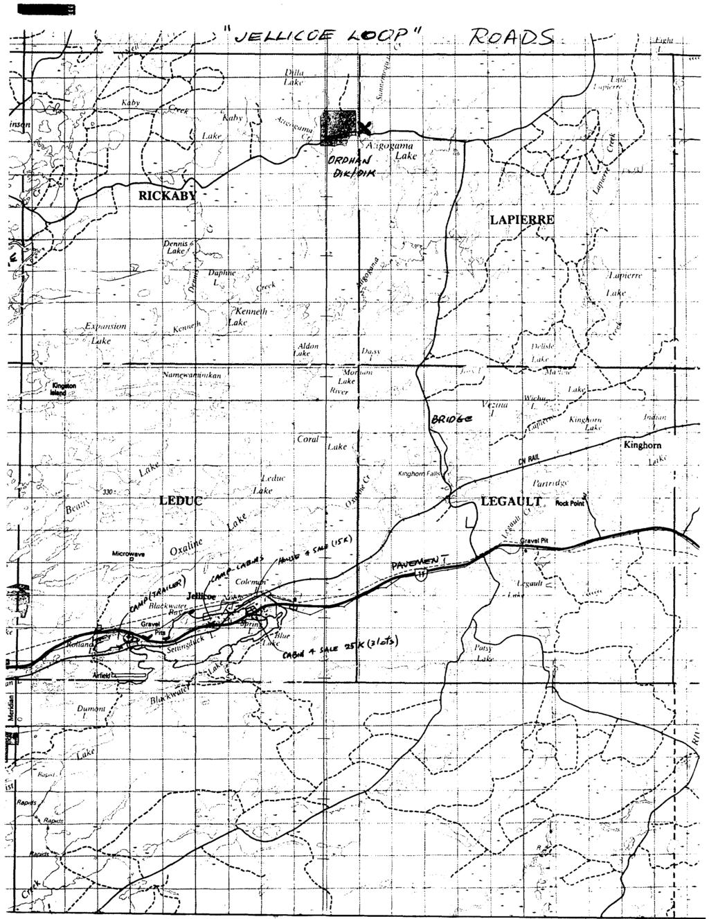
3 INTRODUCTION LOCATION AREA - BEARDMORE- JELLiCOE BELT CLAIM MAP SHEETS - G161/G95 NTS MAP SHEET - 42E 13SE LATITUDE 49" US' LONGITUDE 87" 30' THE PROPERTY SURVEYED IS ON THE BOUNDARY OF RICKABY AND LAPIERRE TOWNSHIPS (JUST NORTH OF ATiGOGAMA LAKE)IN THE THUNDER BAY MINING DIVISION. THE PROPERTY CONSISTS OF ONE CLAIM TB WHICH JOINS ON TO THE EAST OF THE OLD DiK DIK (ORPHAN) MINE PROPERTY WHICH SAW SOME LIMITED PRODUC TION IN THE THIRTIES (TB INCL.[PATENTS!). ACCESS THERE is GOOD ACCESS TO THE PROPERTY VIA THE KINGHORN (ALSO CALLED CAMP 40 OR DELISLE LAKE LODGE) GRAVEL ROAD. TRAVEL 8.5 KMS EAST OF JELLICOE ON HIGHWAY 11, THEN NORTH 13 KMS ON THE KlNGHORN ROAD. TURN WEST AT THE JUNCTION IN THE ROAD AND TRAVEL 4 KMS TO ATIGOGAMA LAKE. THE MAIN TRENCHES ARE 400 AND 700 FEET NORTH OF THE KlNGHORN ROAD FROM THE ATIGOGAMA LAKE LANDING. MAINTENANCE OF THE KING- HORN ROAD CURRENTLY DEPENDS ON LUMBER COMPANY ACTIVITIES. YOU WILL CROSS THE TOWNSHIP LINE ON THE GRAVEL ROAD WHICH ALSO IS CUT OUT FOR A BASELINE 500 FEET EAST OF THE LAND ING. HISTORY THE STURGEON LAKE AREA WAS FIRST EXPLORED FOR IRON IN THE LATE 1800's. IRON FORMATION MAPPED ON ISLANDS IN LAKE l
4
5 NIPIGON WERE LATER TRACED INLAND TO THE EAST. IN 1900 A CONCENTRATED EXPLORATION EFFORT FOR IRON CONSISTED OF GOVERNMENT MAPPING, STAKING AND FOLLOW UP SURFACE DRILL ING. IN THE EARLY 1920's ENTHUSIASM FOR IRON DECLINED BUT INTERESTING GOLD VALUES WERE REPORTED DURING THIS PERIOD. IN 1931, T. JOHNSON DISCOVERED A GOLD BEARING QUARTZ VEIN ON TB11071 JUST NORTH OF ATIGOGAMA LAKE WHICH LATER BECAME THE DIK DIK MINE. KOCH STAKED THE ADJOINING CLAIM TO THE EAST AND THE DIK DlK VEIN WAS TRACED ONTO THE KOCH~DANEFF CLAIM TB AT THE POINT WHERE THE VEIN CROSSES THE LINE IT APPEARS * HOWEVER TO BEND TO A STRIKE OF ALMOST DUE EAST FROM N 40" W. CIRCA : SEVERAL DRILL HOLES WERE INTENDED TO PROBE THE EASTWARD EXTENSION WITH MIXED RESULTS. IN 1986 CANADIAN GOLD RESOURCES CARRIED OUT LINE-CUTTING, GEOPHYSICAL SURVEYING AND A DIAMOND DRILL PROGRAM. GEOLOGY MAPS: PRELIMINARY GEOLOGY P802 OGS MAP 2373 ELMHIRST-RICKABY TOWNSHIPS THE CLAIM SURVEYED IS 95Z COVERED BY OVERBURDEN WITH THE ONLY OUTCROP EXPOSURES BEING VOLCANIC ROCKS EXPOSED ALONG THE WESTERN BOUNDARY. GEOLOGY t THE PRINCIPAL REGIONAL FEATURES OF THIS AREA ARE ELONGATED BANDS OF KEEWATIN VOLCANIC ROCKS AND TIMISKAMING SEDIMEN TARY FORMATIONS EXTENDING FROM LONG LAC TO LAKE NIPIGON AND EVEN FURTHER WEST. (OVER 60 MILES IN LENGTH) 2
6 LARGE GRANITIC BATHOLITHS LIE TO THE NORTH AND SOUTH OF THIS FLOW-SEDIMENTARY BELT. SMALL ACID PLUTONS ARE SCATTERED IRREGULARILY THROUGHOUT THE FLOW FORMATIONS. BANDS OF IRON FORMATION ACT AS MARKER HORIZONS AS THEY ARE TRACEABLE FOR GREAT DISTANCES THROUGHOUT THE BELT BUT ARE NOT STRONGLY PRONOUNCED IN THIS AREA TO THE NORTH AND EAST OF JELLiCOE. GREEN SCHIST FACIES is THE REGIONAL METAMORPHIC GRADE. THE PROPERTY IS NEAR THE BOUNDARY WHERE A GRANITE- GRANODIORITE STOCK INTRUDES INTERMEDIATE LAVAS. THERE ARE SEVERAL VEINS CONTAINED IN THE VOLCANICS ON THE WEST BOUNDARY OF THE CLAIM CLOSE TO THE CONTACT WITH THE GRANODIORITE. THE MAIN VEIN OF INTEREST IS A SHEARED ZONE IN THE GREENSTONE WITH QUARTZ STRINGERS PARALLEL TO THE STRIKE WITH A MORE DIFFUSED MINERALIZATION THAN THAT SEEN ON THE ADJOINING WESTERN CLAIM. MAG SURVEY - GEOPHYSICS GENERAL A BASELINE WAS ESTABLISHED ALONG THE COMMON TOWNSHIP LINE OF RICKABY AND LAPIERRE TOWNSHIPS. PICKET LINES WERE TURNED OFF AT 300 FOOT INTERVALS (3N, 6N, 9N AND 12N) STATIONS WERE ESTABLISHED EVERY 100 FEET ON THE BASELINE AND EVERY 100 FEET ON THE WING LINES. THE SURVEY WAS CONDUCTED AT 50 FOOT INTERVALS. 3
7 INSTRUMENTATION S PARAMETERS THE INSTRUMENT AND PARAMETERS USED FOR THE MAGNETOMETER SURVEY ARE AS FOLLOWS: SURVEY INSTRUMENT: GEOMETRICS 6816/826 TYPE: PROTON PRECISION MAGNETOMETER ACCURACY: +/- l GAMMA MAG GENERAL A MAGNETOMETER SURVEY MEASURES THE MAGNITUDE OF THE EARTH'S MAGNETIC FIELD IN A VERTICAL PLANE (TOTAL FIELD INTENSITY). THE TOTAL FIELD INTENSITY IS NOT PERFECTLY SYMMETRIC ABOUT THE EARTH, BUT VARIES DUE TO NUMEROUS DISCONTINUITIES, THE MOST RELEVANT FOR THE PURPOSES OF MINERAL EXPLORATION BEING THE ANOMALOUS SET OF FEATURES CAUSED BY LOCAL VARIATIONS IN THE MAGNETIC MINERALS OR OTHER FEATURES OF INTEREST WHICH DISTORT THE LOCAL MAGNETIC FIELD. AS WELL AS SPATIAL VARIATIONS IN THE EARTH'S MAGNETIC FIELD, THERE ARE VARIATIONS WITH RESPECT TO TIME. THESE DAILY OR DIURNAL VARIATIONS OCCUR PRIMARILY DURING THE LOCAL DAYLIGHT HOURS AND ARE OF AN UNPREDICTABLE NATURE. IN ORDER TO CORRECT FOR THESE VARIATIONS, A BASE STATION IS ESTABLISHED WITH READ INGS TAKEN AT REGULAR INTERVALS (SECONDS TO MINUTES) TO BE USED TO ESTABLISH A BASE VALUE. ADDITIONS OR SUBTRACTIONS ARE CALCULATED TO MAINTAIN THE BASE VALUE AND THESE ARE APPLIED TO THE SURVEY DATA TO PROVIDE A CONSTANT LEVEL. RESULTS THE RESULTS OF THE MAG SURVEY ON THE CLAIM WAS GENERALLY VERY "FLAT* WITH THE ONLY PRONOUNCED AREA OF CONTRAST BEING AN ANOMALOUS HIGH IN THE NORTHWEST CORNER WHERE HIGHER READ INGS OF SEVERAL HUNDRED GAMMAS ABOVE BACKGROUND WAS DETECTED
8 DURING THE SURVEY. CONCLUSIONS MAGNETITE HAS BEEN FORMED ALONG THE EDGE OF THE GRANO DIORITE BODY DUE TO CONTACT METAMORPHISM. THE GROUND MAG SURVEY COINCIDES WELL WITH THE KNOWN AIRBORNE MAG - MNDM 1989 SHEET No RECOMMENDATIONS STRIPPING AND WASHING OF TRENCHES IN THE AREA OF THE MAG HIGH SHOULD BE CARRIED OUT AND THE AREA GEOLOGICALLY MAPPED.
9 L LA -l 921 P l E R R E T/GOGA MA LAKE ^ 3M o m I h- T I9648f O o cc o b. --2M - J J - - -

10 Onta/K* Ministry of Northern Development and Mine* Report of Work Conducted After Recording Claim Mining Act Transaction Number Perec/.formation cohacted on this form Is obtained under the authority of the Mining Act. This Information will be used for correspondence. Questions about this collection should be directed to the Provincial Manager, Mining Lands, Ministry of Northern Develooment ami Mine*. Fourth n/w 1*0 Sudbury, Ontario, P3E 6A5. telephone (705) Instructions: - Please type or print and submit in duplical - Refer to the Mining Act and Regulations ft Recorder. - A separate copy of this form must be com^ 42Ei4swooi LAPIERRE LAKE - Technical reports and maps must accompany this form in duplicate. - A sketch, showing the claims the work is assigned to, must accompany this form. 900 Hokwrts) M- Client No. mss? THOM TownslVArea MofOPtan 3433 Wortc From:. 73 To: J O Work Performed (Check One Work Group Only) Work Group Geotechnical Survey Physical Work, Including Drilling Lffvl f COTT IKi Q H 'OftG. Type Rehabilitation Other Authorized Work Assays Assignment from Reserve RECEIVCD AULi ^ 9 iyy4 MINING LANnspRrt Nn. Total Assessment Work Claimed on the Attached Statement of Costs Note: The Minister may reject for assessment work credit all or part of the assessment work submitted tf the recorded holder cannot verify expenditures claimed in the statement of costs wtthin 90 days of a request for verification. Persons and Survey Company Who Performed the Work (Give Name and Address of Author of Report) Name Address JAM e s f?- 6. [fakir vj fvj St,. TlVutd Pert. O A\y tlim vi.. l H u M (attach a schedule H necessary), Two r* be"* Certification of Beneficial Interest * See Note No. 1 on reverse side l certify that at the time the work was performed, the claims covered in this work report were recorded in the current holder's name or held under* beneficial Interest by the current recorded holder. Certification of Work Report i certify that l have a personal knowledge of the its completion and annexed report is true. Name and Address of Penon Certifying Tetepone No. i) For Office Use Only Total Value Gr. Recorded Date Dste Recorded /l'j6. Deemed Approval Dale AJOV 7 Date Notice for Amendments Sent Data {\OG tchq Recorded Holder or Agent (Signature) 6UX6LAJU/ M. - /cllurtu-, 1 V facts set forth in this Work report, having performed the work or witnessed same during and/or after 3-1*15 ftvuv (e/ K.' 0/^3.7k uu&t Certified By (Signature) Mining Recorder/ ''/k UU ; Oats Approved /L &&V C^f^j. PjC 4^*2^- /^/^A ^ J 0241 (KV91)
11 -O 5~ O t q I r Credits you are claiming in this report may be cut back. In order to minimize the adverse effects of such deletions, please indicate from which claims you wish to priorize the deletion of credits. Please mark (^) one of the following: 1. D Credits are to be cut back starting with the claim listed last, working backwards. 2. D Credits are to be cut back equally over all claims contained in this report of work. 3. D Credits are to be cut back as priorized on the attached appendix. * In the event that you have not specified your choice of priority, option one will be implemented. O * - f ' J Note 1: Example* of beneficial Interest are unrecorded transfers, option agreements, memorandum of agreements, etc., with respect to th* {Ttlnlng claims. Note 2: If woifc has been performed on patented or leased land, please complete the following: 1 certify that the recorded holder had s beneficial Interest in the patented or leased larat the time the work was performed. Signature Date
12 (S) Ontano ministry 01 Northern Development and Mine* Ministere du Jeveloppement du Nord et des mines Statement of Costs for Assessment Credit Irtat des coots aux fins du credit devaluation Mining Act/Loi sur les mines Personal information collected on this form is obtained under the authority of the Mining Act. This information will be used to maintain a record and ongoing status of the mining claim(s). Questions about this collection should be directed to the Provincial Manager. Minings Lands. Ministry of Northern Development and Mines, 4th Floor. 159 Cedar Street, Sudbury, Ontario P3E 6A5. telephone (705) Transaction HoJN* de transaction S Les renseignements personnels, contenus dans la presents formule sor recueillis en vertu de la Lol sur les mines et sen/iron! a tenir a jour un registr des concessions minieres. Adresser toute quesiton sur la cdlece de ce renseignements au chef provincial des terrains miniers, ministere d Developpement du Nord et des Mines, 159. rue Cedar, 4* etage, Sudbur (Ontario) P3E 6A5, telephone (705) Direct Costs/CoOts directs Type Wage* Salalra* Supplies Used Foumtturas utinsee* Equipment Rental Location de materiel m Description Labour 3 m e. r\ 1 Main-d'oeuvre 50.0^ Field Supervision Supervision sur le terrain Type MI\P * Re ve? B. T l rr\4a H A^\ Type VwtKiT QATI cri6^ 6AS*^..tec CH^.wS^w Type l^^/^d^s/'sb. f^ F- lw en AUb ~ H Amount Montant 3-150" 22* HO-- Contractor's and Consultant's Fees Draft* de r entrepreneur t de ('expert- u^o.- to- *foo- Tot it Direct Costs Totsl de ; coots directs -v-f Totals Total global ttn-tf 2. Indirect Costs/CoQts indirect* * * Note: When claiming Rehabilitation work Indirect costs are not allowable as assessment work. Pour to remboursement des travaux de rehabilitation, les couts Indirects ne sont pas admlssibtos en tant que travaux devaluation. Type Transportation Transport RoP*D Food and Lodging Nounrttureet Mbergement Mobilization and MobtMsatlon et dtmomllaauon Description Type TROC.K p Tit t PS Jeuuict-e - /M rb PrtC.Pe-R.TV D'Wf - fieiurio - l^i^5 k^vs ^.5o TRKv/eci-ftiftc CC-i-t w\ (X.R. diroc-er.e^, Amount Montant VftSJ SP\.64 Sub Totsl of Indirect Costs Totsl psrtlel des couts indlrects Amount Allowable (not greater than 20H of Direct Costs) Montant admissible (n'exeedant paa 20 H des eoota dkecta) (Total ef Direct and Aiewabls Indirect coats) toduermt d*evehmtte B (Total daa M M In Totals Total global. ^(3?fr :.-;K^l^*SSr', --^a^v.- &T' ; ^teh'\! 'rtsse-fvsr***^ ^a&ci^-^' - : Iff^/; ^4.*r7l *o^-.tt' es claimed in this statement of costs within 30 days of a request for verification. If verification is not made, the Minister may reject for assessment work all or part of the assessment work submitted. Note : Le titulaire enregistre sera tenu de verifier les depensesdemandeesdan* le present etat des couts dans les 30 jours solvent une demand* i ce" effet. SI la verification n'est pas effectuee. le mwetre pent rejeter toui ou une partle des travaux d'evaluatton presentee. Rllng Discounts 1. Work filed within two years of completion is claimed at 100"Vb of the above Total Value of Assessment Credit. 2. Work filed three, four or five years after completion is claimed at 50"M) of the above Total Value of Assessment Credit. See calculations below: Remlsee pour depot 1. Les travaux deposes dans les deux ans suivant lew achevemerrt sont re^rjxxjrsesa1m%detavateurtotalesus^nentjonneedu<sb*d'evakja^ion 2. Les travaux deposes trois, quatre ou cinq ans apres leur achevement sont rembourses a 50 ^ de la valeur totale du credit d'evaluatior susmentionne. Voir les calculs ci-dessous. i Total Value of Assessment Credit x 0.50 Total Assessment Claimed Valeur totale du credit devaluation x Evaluation totale demandee Certification Verifying Statement of Costs l hereby certify: that the amounts shown are as accurate as possible and these costs were incurred while conducting assessment work on the lands shown on the accompanying Report of Work form. Attestation de I'etat des coots J'atteste par la presente : que les montants indiques sont le plus exact possible et que ce; depenses ont et6 engagees pour effectuer les travaux d'evaluatior sur les terrains indiques dans la formule de rapport de travail ci-joint. that as to make this certification ^ li l am authorized Et qu'a A litre tltl^ de W.., u--.n -.- je lv suis WUU autorisg O (titulaire enregistra. reprasantant. posts occup^ dans la compagnie) a faire cette attestation. j Signature i, i - L '-'--^ \^ ^ ' ' ^ XL /c.. Oat* / -die-' U Noia : Dans cene (ormuie, lorsqu'ii ddsi^ne des personnes, le masculin est uiifisd au sens '
13 ./ntario Ministry of Northern Development and Mines Ministers du Developpement du Nord et des Mines Geoscience Approvals Section 933 Ramsey Lake Road 6th Floor Sudbury, Ontar io P3E 6B5 November 21, 1994 Our File: Transaction #: W Mining Recorder Ministry of Northern Development an Mines 435 James Street South Suite B003 Thunder Bay, Ontario P7E 6E3 Dear Sir/Madam: Telephone: Fax: (705) (705) Subject: APPROVAL OF ASSESSMENT WORK CREDITS ON MINING CLAIM TB IN RICKABY t LAPIERRE TOWNSHIPS The 45 days specified in the Notice of Credit Reduction dated October 4, 1994 have passed. Assessment work credits have been approved as outlined on the attached Assessment Work Credit Form for the submission. The credits have been approved under Section 14, Geophysics (Mag), Mining Act Regulations, The approval date is November 21, i'' If you have any questions regarding this correspondence, please contact Lucille Jerome at (705) ORIGINAL SIGNED BY: Ron C. Gashinski Senior Manager, Mining Lands Section Mining and Land Management Branch Mines and Minerals Division Jk LJ/jl M Enclosures: cc: Resident Geologist Thunder Bay, Ontario ssessment Files Library Sudbury, Ontario
14 ASSESSMENT WORK PERFORMED ON CLAIM(S) DATE: NOVEMBER 21, 1994 FILE NUMBER: TRANSACTION NUMBER: W RECORDER HOLDER: AUDREY M. HAYES CLIENT NUMBER: TOWNSHIPS: RICKABY AND LAPIERRE CLAIM VALUE OF WORK DONE ON THIS CLAIM
15 002 \ N SURVEYS:- REFERENCES FULLERTON LAKE G-40 SOUTH BOUNDARY OF HIPEL, LA PI ER RE, RICKABY AND THE EAST BOUNDARY OF RICKABY TOWNSHIP SURVEYED BY H.W. SUTCLIFFE O.L.S FIELD NOTE BOOK N? 2580 NORTH BOUNDARY OF LAPIERRE, HIPEL, AND THE WEST BOUNDARY OF AND COLTER HIPEL, TOWNSHIPS SURVEYED BY C.V. GALLAGHER O.L.S FIELD NOTE BOOK N? 2378 EAST BOUNDARY t)f LEDUC AND THE NORTH BOUNDARY OF RICKABX TOWNSHIPS SURVEYED BY J.M.KILKENNY O.L.S FIELD NOTE BOOK N? 2394 ALTITUDE 24 r 23' 22' i " ^r II9705V ELWOOD S LAKE ' EATON CH REFERENCES TOPOGRAPHY LAKES. RIVERS, ETC.. FROM FOREST RESOURCES INVENTORY SHEET No SUNNEMEQUAT LAKE \ ' WEST 5 M 4,M S. 89 e 57'48"W. 3,M WEST ^.2 M h- S. 89" 58' 58" W. NOTICE; The information that appears on this map has been compiled from various sources, and accuracy is not guaranteed. Those wishing to stake mining claims should consult with the MINING RECORDFR, Ministry of Northern Development and Mines, for additional information on the status of the lands shown hereon LAPIERRE LA K E DISPOSITION OF CROWN LANDS f -M t S, WiNiNi i HICiH IS i '-i' " t Hli i M 1 S '''j' rji, l * ;i lit l S OfJl ^,H l S.'"" -V l i- li.h l ', DM t,'i'j f.i, H K, H I ' l '(Ml t,' j ' Z- ' -,'S. J -U ^933396^- LA P l E R R E HIPEL PAVED ROAD LEGEND GRAVEL ROAD A 71 GOGAMA OTHER ROADS TRAIL OR PATH HIGHWAY ROUTE No ELECTRIC POWER LINE TELEPHONE LINE RAILROAD ft RIGHT OF WAY RAPIDS, PORTAGE NON-PERENNIAL STREAM EDGE OF CLEARING TREELESS MUSKEG OR MARSH JI BRIDGE. BUILDINGS SCALE: 1 INCH * 40 CHAINS LAPIERRE: ^i- -i. -4-^-1--. 'OO710S L*c*4*e ^aaw**- l ^07490 LAPIERRE LAKE , ^. l -L L -J - I - ^a07ia^ ' iftme* 1 --J ---- l ' l 9O7857I i -4 I. - l. ^ Lil l l ( *4y~-^^ ^^V? *J"J3gl^~) "vuvuo ~T ~ ~ "1*614412, RECEIVER AUG M. N. R. ADMINISTRATIVE DISTRICT NIPIGON-GERALDTON MINING DIVISION THUNDER BAY AND TITLES/ REGISTRY DIVISION THUNDER BAY M WEST. LEGAULT TWP AST- FOR STATUS REFER TO PLAN G-170 JORY LAKE l Aj 'WV WES \ l 31 M OR COLTER TWR STATUS REFER TO TWP PLAN MININGL,' Ministryof Natural Resources Land Management Branch i G) ^ JANUARY, 1981 SOUTH OF LEGAULT TWP G-131 N SbRVlCF MAY l 7, 1993
Assessment Report by the Canadian Nickel Co. Ltd. Magnetometer Survey. Larder Lake Mining Division Lebel Tovnship, Ontario
 32084Nwea67 2.331* LEBEL 010 Assessment Report by the Canadian Nickel Co. Ltd. Magnetometer Survey Larder Lake Mining Division Lebel Tovnship, Ontario Claims L-531657 L-531658 L-531111 Map No.: M-359,
RECEIVED. for Sharpmin Developments Incorporated FEB Geologist January 4, 1996 Toronto, Ontario MINING LANDS BRANCH
 31F06NE0001 2 164OO SEBASTOPOL 010 Analytical Results for Apatite Samples from Turner's Island, Island 'D', Mining Claim SO 1150877, Sebastopol Township, Renfrew County, Southern Ontario Mining Division
2. i. GEOLOGY Vincent Twp., Ontario NTS 42E/12. By: Barbara Kowalski FOUNDER RESOURCES INC. 42E12NE VINCENT
 42E12NE0062 2.15658 VINCENT 010 2. i FOUNDER RESOURCES INC. GEOLOGY Vincent Twp., Ontario NTS 42E/12 September 21, 1994 By: Barbara Kowalski 42E12NE0062 2.15658 VINCENT 010C TABLE OF CONTENTS TITLE PAGE
Within. Mineral Claim
 31E12SE2001 2.19268 RYERSON 010 2.19-68 January 15,1999 ASSESSMENT REPORT ON A GEOLOGICAL MAPPING PROJECT Within Mineral Claim 1077246 Ryerson Township, Southern Ontario TABLE OF CONTENTS 1. Summary And
Magnetometer Survey on the
 42E13NE8400 2.15192 CASTLEWOOD LAKE 010 Magnetometer Survey on the FOUNDER RESOURCES INC. Conglomerate Lake Property Castlewood Area/ Ontario District of Thunder Bay Oct. 15, 1993 By: Barbara Kowalski
SELCO EXPLORATION COMPANY LIMITED
 --..-..-...-.....l.iibibiiiiiiiiiiiiiii II III S2J16NW9001 52J16NW0014A1 PASHKOKOGAM LAKE 0 10 SELCO EXPLORATION COMPANY LIMITED GEOPHYSICAL REPORT CLAIMS 200696 TO 200707 PATRICIA MINING DIVISION August
XRAL X-RAY Bharti Engineering Associates Inc Lasalle Blvd. P O Box 2336 Sudbury (M P3A4S8. DATE SUBMITTED 9-Aug-89
 XRAL X-RAY 1885 LESLIE S TEL: (416)445 41113SE9429 2.12731 ULSTER 010 C ERT X F X O A.T E TO: BHARTI ENGINEERING ASSOCIATES INC. ATTN: HAROLD J. TRACANELLI 1009 LASALLE BLVD P.O. BOX 2336 SUDBURY, ONTARIO
42AeSNEeSe GODFREY ASSESSMENT WORK FOR RICHARD MATHIEU ON THE GODFREY TOWNSHIP PROPERTY TIMMINS, ONTARIO RECEIVED MINING LANDS BRANCH
 42AeSNEeSe7 2.14685 GODFREY 010 ASSESSMENT WORK FOR RICHARD MATHIEU ON THE GODFREY TOWNSHIP PROPERTY TIMMINS, ONTARIO RECEIVED AUG13 1992 MINING LANDS BRANCH PROSPECTING WORK (a) CLAIM LOCATION Area:...
31L11NW MCAUSLAN 010 A REPORT ON A RECONNAISANCE GEOLOGY SURVEY PROJECT
 31L11NW9557 2.15064 MCAUSLAN 010 2. 15064 A REPORT ON A RECONNAISANCE GEOLOGY SURVEY PROJECT IN MCAUSLAN TOWNSHIP, ONTARIO FOR CENTRAL ONTARIO NATURAL STONE COMPANY LIMITED,o RECEIVED JUN l 5 1993 MINING
4. Geological maps published by the Ontario Department of Mines.
 52J08NWei45 S2J08NWa6B1 SMYE 010 AMALGAMATED RARE EARTH MINES LTD. *, SAVANT LAKE PROSPECT x ONTARIO INTRODUCTION t This Is a report on a group of 28 claims control led by Amalgamated Rare Earth Mines
STURGEON BRIDGE PROPERTY. Fred Checkley Claims
 PROV.NCiA:- RECORDING OFFICE - SUDBURY RECEIVED DEC 2 3 2002 A.M. l o \ j jj *vv/}^ P.M. 7 8 9 IQ 11 I2 1 2[3 4 S 6 STURGEON BRIDGE PROPERTY Fred Checkley Claims The property lies in the north-central
John A. Wakeford Noranda Exploration Co., Ltd, November 4, 1980 rinnnins, Ontario
 42CC1NEfc4e9 801101 ECHUM 010 " ' i-^y&sg?' '.. -.r. K;VW\\:.!^-*.]-^--'^-r-r^Pj^Q..-. ;,: v 1,;-'-,..- ^^-^^^^ysr-r^ijjfiv^jj. v -." ". '. ' "i - '' '. '':.;': s.'.ilv'., p...--'*l r-j@tw IP ^vt'.'v*:-^
Toronto, Ontario November 16, This report may not be reproduced, in whole or in part, without the written permission of Derry, Michener S Booth.
 13 2.1354 L ITTLE 010 GEOPHYSICAL SURVEYS, LITTLE TOWNSHIP CLAIM GROUP OB-F TIMMINS AREA PORCUPINE MINING DIVISION, ONTARIO Toronto, Ontario November 16, 1973 This report may not be reproduced, in whole
Rubicon Minerals Corporation. Physical Work Submission Report June, RED LAKE PROPERTY MECHANICAL STRIPPING South Pipestone Bay
 Rubicon Minerals Corporation Physical Work Submission Report June, 2001 RED LAKE PROPERTY MECHANICAL STRIPPING South Pipestone Bay Ball Township Red Lake Mining Division NTS 52/N4 2.216 A /^ r--^'^-, t'n
SUPPLEMENT TO MAGNETOMETER 6 ELECTROMAGNETIC SURVEY REPORT. DATED NOVEMBER l, 1973 CIGLEN INVESTMENTS LIMITED CLAIMS GROUP BAD VERMILLION LAKE AREA
 ^ A R l ^ 1974 010 PROJECTS UNIT SUPPLEMENT TO MAGNETOMETER 6 ELECTROMAGNETIC SURVEY REPORT DATED NOVEMBER l, 1973 CIGLEN INVESTMENTS LIMITED CLAIMS GROUP BAD VERMILLION LAKE AREA DISTRICT OF RAINY RIVER
ZENMAC METAi, MINES LIMITED. SCHHKIBEK, ONTnHlO. PURVEY OK THE NI'COPOR PROPERTY
 63.2625 PAYS PLAT LAKE 010 ZENMAC METAi, MINES LIMITED SCHHKIBEK, ONTnHlO. PURVEY OK THE NI'COPOR PROPERTY IS'iRODUCTIQM The property, about 6 miles north of Schreiber, has been held by various people
BLACK PEARL MINERALS INC.
 52F07SE0008 2.16968 MEGGISI LAKE 010 BLACK PEARL MINERALS INC. GEOPHYSICAL SURVEYS «SUNSHINE LAKE PROPERTY» Octobre 1996 «* TABLE OF CONTENTS I - INTRODUCTION P. 1 II - PROPERTY P. 1 III - LOCATION & ACCESSIBILITY
RECEIVED MINING LANDS SECTION. a.9535 MCTAVISH. E.A. JENNINGS, H.D.Se. Thunder Bay, Ontario September GEOLOGY OF THE THUNDER BAY AMETHYST MINE
 a.9535 MCTAVISH 010 GEOLOGY OF THE THUNDER BAY AMETHYST MINE AND PRECIOUS PURPLE GEMSTOHES CLAIMS E.A. JENNINGS, H.D.Se. Thunder Bay, Ontario September 30 1985 RECEIVED MOV l o 1986 MINING LANDS SECTION
ASSESSMENT REPORT ON THE PEAVINE PROJECT. DGW & Associates # Alberni Street, Vancouver, British Columbia, V6E 4V2
 ASSESSMENT REPORT ON THE PEAVINE PROJECT KAMLOOPS MINING DIVISION BRITISH COLUMBIA NTS 082M 12 Latitude 51 36' 19.0"North -- Longitude --119 47' 27.0"West UTM Zone 11, NAD 83 5720827N 306744E Prepared
REPORT ON GEOLOGICAL MAPPING OF CLAIM SHAW TOWNSHIP PORCUPINE MINING DIVISION) NORTHEASTERN ONTARIO FOR LAURION GOLD INCORPORATED
 NORTHEASTERN ONTARIO FOR LAURION GOLD INCORPORATED") REPORT ON GEOLOGICAL MAPPING OF CLAIM 1180899 SHAW TOWNSHIP PORCUPINE MINING DIVISION) NORTHEASTERN ONTARIO * O Q Q fi FOR LAURION GOLD INCORPORATED Schumacher, ON November 29th, 2004 Leslie A. Tihor Tihor
REPORT ON GEOLOGICAL MAPPING OF CLAIM 1180899 SHAW TOWNSHIP PORCUPINE MINING DIVISION) NORTHEASTERN ONTARIO * O Q Q fi FOR LAURION GOLD INCORPORATED Schumacher, ON November 29th, 2004 Leslie A. Tihor Tihor
Introducti on. Land Survey. Geomagnetic Survey. Geomagnetic Results and Interpretati ons - Conclusions and Recommendations C
 m M 42A86SW8281 63.42 PRICE 010 C O H T E H l 42A86SW828I 63.42 PRICE 010C Introducti on Land Survey Geomagnetic Survey Geomagnetic Results and Interpretati ons - Conclusions and Recommendations - - -
ASSESSMENT' REPORT GEOPHYSICAL REPORT ON THE ATTORNEY 2 CLAIM (4 UNITS) OMINECA MINING DIVISION SHEILA A. CRAWFORD.
 OMINECA MINING DIVISION SHEILA A. CRAWFORD.") ASSESSMENT' REPORT GEOPHYSICAL REPORT ON THE ATTORNEY 2 CLAIM (4 UNITS) OMINECA MINING DIVISION by SHEILA A. CRAWFORD LOCATION: 57z17' N Latitude 127 11' W Longitude N.T.S. 94E/6E OWNER/OPERATOR: SEREM
ASSESSMENT' REPORT GEOPHYSICAL REPORT ON THE ATTORNEY 2 CLAIM (4 UNITS) OMINECA MINING DIVISION by SHEILA A. CRAWFORD LOCATION: 57z17' N Latitude 127 11' W Longitude N.T.S. 94E/6E OWNER/OPERATOR: SEREM
Work Report #2 Mining Claims & MacGregor Township, G-062 May 11,2004 By: Marc Ciccarelli - Claim Holder
 9 2 7672 Work Report #2 Mining Claims 1247155 & 1247156 MacGregor Township, G-062 May 11,2004 By: Marc Ciccarelli - Claim Holder This report includes a brief geological description of the rocks on these
1 CLAIMS GEOPHYSICAL REPORT ON BOYAL SITUATE NORTHEAST OF TILLICUM MOUNTAIN GOLD AREA BURTON - NAKUSP SIQCAEJ MINING DIVISION
 GEOPHYSICAL REPORT ON BOYAL 1 CLAIMS SITUATE NORTHEAST OF TILLICUM MOUNTAIN GOLD AREA BURTON - NAKUSP SIQCAEJ MINING DIVISION CONSULTING GEOLOGIST AUGUST 1983 VANCOUVER B *C INDEX INTRODUCTION ooa,.eoaaa.aaaoaaooaoa~ao~o
7 MILES WEST OF PORT HARDY, B.C.
 GEOPHYSICAL REPORT VERTICAL INTENSITY MAGNETOMEER SURVEY ON LUK CLAIMS, 7 MILES WEST OF PORT HARDY, B.C. 50' 127O SE BY R. E. SHIELDS UNDER SUPERVISION OF J. R. BILLINGSLEY FOR SECOND0 MINING LTD. (N.
PROSPECTING REPORT THE WALLACE CLAIM OMENICA MINING DIVISION. 54" x6" 3.d d. for. Reako Exlorat ions Ltd. Wallace Rev. C.G.
 PROSPECTING REPORT ON THE WALLACE CLAIM OMENICA MINING DIVISION 54"44 14 1x6" 3.d d by David A. Howard P.Eng. for Reako Exlorat ions Ltd. Claim Locat ion Wallace Rev. C.G. #1560 Dome Mountain Area 9 3
MINING CLAIMS t A
 2L**NE* 2.2*38 METCALFE LAKE OO CESCRIPTION OF WORK PERFORMED ON MINING CLAIMS 3. 3. 32. 327t 3260. A 326 3 Located and cleaned out three previously excavated rock trenches* Trenches measured 00 feet,
for the Greenwood Mining Division, B.C. NTS 82E/7W Latitude 49' 27' W, Longitude 118' 5 Prepared by a= D. Dylan Watt, B.Sc.
 t. b LOGnO: 37~ -08 m. ACTIO#: for the AMP AMP 2 AMP 3 t AMP 4 CLAIMS Greenwood Mining Division, B.C. NTS 82E/7W Latitude 49' 27' W, Longitude 8' 5 %E c,w zc *& a w Prepared by a= -4c. D. Dylan Watt, B.Sc.
. QOtSI. Timmins Area. Geological Report NE Eldorodo Township Property. June, 1994 D R. 42A06SE M93E DORADO "" 010
 . QOtSI 42A06SE00462 1M93E DORADO "" 010 Geological Report NE Eldorodo Township Property Timmins Area June, 1994 D R. mile Langmuir Tp. - M.292 Geological Report NE Eldorodo Township Property Timmins Area
for the Greenwood Mining Division, B.C. NTS 82E/7W 29' W, Longitude 118' 53' N Prepared by D. Dylan Watt, B.Sc.
 for the FltE NO: u VOLT 1, VOLT 2, VOLT 3, & VOLT 4 CLAIMS Greenwood Mining Division, B.C. NTS 82E/7W Latitude 49' 29' W, Longitude 118' 53' N Prepared by D. Dylan Watt, B.Sc. #309-1996 Trutch Street Vancouver,
31M05SE LORRAIN 010
 LATOLIR LAKE VLF SURVEY 31M05SE0003 2.4460 LORRAIN 010 The EM-16 survey program on the Latour Lake Property located in Lorrain Township, District of Temiskaming, Sudbury Mining Division has been extended
Simplified exploration work report
 Simplified exploration work report Work Report of exploration and examination of outcrops of rock and boulders Report on stripping and excavating work of $ 5 000 or less.(section 81 of regulation) Report
We are committed to providing accessible customer service. If you need accessible formats or communications supports, please contact us.
 We are committed to providing accessible customer service. If you need accessible formats or communications supports, please contact us. Nous tenons à améliorer l accessibilité des services à la clientèle.
43E14SW8500 2,15319 LAPIERRE LAKE 010 ATIGOGAMA LAKE AREA NORTHWEST LAPIERRE TWP 4 CLAIM GROUP DAVID K. KINDLA OP93-252
 43E14SW8500 2,15319 LAPIERRE LAKE 010 ATIGOGAMA LAKE AREA NORTHWEST LAPIERRE TWP 4 CLAIM GROUP DAVID K. KINDLA OP93-252 1993 42EMSW8500 2.15319 LAPIERRE LAKE 010C TABLE OF CONTENTS LOCATION MAP.................................
WAONEK-MILLS JPHVSiCAL SURVEYS
 xxxxxx L. i* ^- O PHONE HO, C - 7526 XXXXXXX) WAONEK-MILLS JPHVSiCAL SURVEYS XXXXXAAA SUITE 401, 62 RICHMOND ST. WEST 15 MEREDITH. IEREDITH. C RESCENT TOR.ONTO. TORONTO, CANADA till6ne0082 0815C1 SCHOLES
Report on The Magnetic Survey. Property of Loydex Resources Inc. Keigat Lake Area. Red Lake Mining Division
 010 Report on The Magnetic Survey On The Property of Loydex Resources Inc. SANDY POINT PROJECT Keigat Lake Area District of Kenora, Patricia Portion Red Lake Mining Division N.T.S. 52-N-8 Whitby, Ontario
We are committed to providing accessible customer service. If you need accessible formats or communications supports, please contact us.
 We are committed to providing accessible customer service. If you need accessible formats or communications supports, please contact us. Nous tenons à améliorer l accessibilité des services à la clientèle.
DOMINION GULF COMPANY 203 BAY STREET TORONTO l, ONTARIO, CANADA
 31M12SE8ai2 6 3.281 CASEY DOMINION GULF COMPANY 203 BAY STREET TORONTO l, ONTARIO, CANADA 010 E. W. WE8TRICK GENERAL AOENT IN REPLY REFER TO: February l, 1952. REGISTERED Mr. H. C. Rickaby, Deputy Minister
December 6th I960. President and Directors, Chipman Lake Mines Ltd. 25 King Street West, Toronto.
 OFFICE: EM, 3-3933 RES.: HU. 1-1265 "' Mfc 42A85NE0127 63.1089 GODFREY 010. D. President and Directors, Chipman Lake Mines Ltd. 25 King Street West, Toronto. December 6th I960 REPORT ON GEOPHYSICAL SURVEY
CONSULTING GEOLOGICAL 8: MINING ENGINEERS STINGS STREET DA V6E 2E9 GEOPHYSICAL SURVEY SILVER QUEEN 2 ZEBALLOS AREA. B.C.
 DOLMAGE CAMPBELL & ASSOCIATES (1 975) LTD. CONSULTING GEOLOGICAL 8: MINING ENGINEERS STINGS STREET DA V6E 2E9 '' 1E O L 0 G I C A.L B'x;&a:f2:#& 'SESSMENT REPObT 12, Assessment RESOURCES LTD. 111 ReDort
Drilling. What is the Activity?
 Drilling What is the Activity? Drilling is a critical activity in mineral exploration. There are several types of drilling. Diamond drilling is the most common type of drilling conducted in Ontario. It
MAGNETIC SURVEY REPORT. on the O'BRIEN CLAIM GROUP. Deloro Township Porcupine Mining Division, Ontario. for PAMOUR PORCUPINE MINES LIMITED
 42A06NE0456 2.7439 DELORO 010 MAGNETIC SURVEY REPORT on the O'BRIEN CLAIM GROUP Deloro Township Porcupine Mining Division, Ontario as se C/J 1* m O for PAMOUR PORCUPINE MINES LIMITED by Kian A. Jensen,
TECHNICAL REPORT ON THE BLACK CREEK PROPERTY FOR CARRIE ARRAN RESOURCES BLACK TOWNSHIP LARDER LAKE MINING DIVISION ONTARIO
 TECHNICAL REPORT ON THE BLACK CREEK PROPERTY FOR CARRIE ARRAN RESOURCES BLACK TOWNSHIP LARDER LAKE MINING DIVISION ONTARIO B.J. McKay, 8 February 2011 Keewatin, Ontario TECHNICAL REPORT BJML 2011 Table
July Exploring for Canadian Gold in the Rainy River District of Ontario
 July 2013 Exploring for Canadian Gold in the Rainy River District of Ontario 1 Forward Looking Statements Some of the statements in this document may be deemed to be "forward-looking statements". All statements
NELSON GRANITE LIMITED. Test Quarrying, Sample Block Removal. Sawing and Polishing Tests. Mining Claim K-l Kilgour Lake Area NTS: 52K 4SW
 l 52K04SW2005 2.20708 KILGOUR LAKE 010 2.20708 NELSON GRANITE LIMITED Test Quarrying, Sample Block Removal Sawing and Polishing Tests Mining Claim K-l 149856 Kilgour Lake Area NTS: 52K 4SW Kenora Mining
Nickel Division - Sudbury Operations
 * *-.. FALCONBRIDGE NICKEL MINES LIMITED Nickel Division - Sudbury Operations Falconbridge, Ontario 002261 GRAHAM 010 GEOLOGY OF TllE NORTH QUARTER OP LOT 2, CON. IV, GRAHAM TOWNSHIP, DISTRICT OP SUDBURY,
RECEIVED GOLD PROPERTY REPORT ON THE 1992 EXPLORATION OF THE LASSILA-HOUGHTON ELMHIRST TWP. MINING LANDS BRANO NTS 42E/13.
 42E13SE0603 E.14999 ELMHIRST 010 1499 REPORT ON THE 1992 EXPLORATION OF THE LASSILA-HOUGHTON ELMHIRST TWP. GOLD PROPERTY NTS 42E/13 Latitude 490 50* Longitude 870 21' Date: December 1992 By: P. Lassila
DiaMine Exploration Inc. Pickle Lake Option Property
 DiaMine Exploration Inc. Pickle Lake Option Property Rock Sampling Program and Field Observations Claims 4249174, 4249175, 4249176 and 4249177, Kapkichi Lake Area (G-2081) And Claims 4249178, 4249179 and
GEOPHYSICAL REPORT. Airborne Magnetometer Survey. of the SHEEP-GOAT GROUP OF MINERAL CLAIMS. near Li l looet, B.C.
 GEOPHYSICAL REPORT 977 Airborne Magnetometer Survey of the SHEEP-GOAT GROUP OF MINERAL CLAIMS near Li l looet, B.C. Lillooet Mining Division (Lat.51 'lot Long. 122 40' 7 5t0[2L05E. for DUFFEY LAKES MINES
* STUART W. DEVEAU. r '/i SEPTEMBER 1995 NTS: 52K/13 PLACER DOME CANADA LIMITED PROJECT CLAIM KRL
 S2K13NW0011 2 16217 BAIRD 010 PLACER DOME CANADA LIMITED PROJECT 413 - CLAIM KRL 1184166 GEOLOGICAL REPORT - 1995 WORK PROGRAMME BAIRD TOWNSHIP, ONTARIO NTS: 52K/13 r '/i SEPTEMBER 1995 * STUART W. DEVEAU
NTS 93L/9W GEOCHEMICAL AND GEOPHYSICAL REPORT MONA CLAIM OMINICA MINING DIVISION. Lati tude 54036'N; Longitude 'W
 GEOCHEMICAL AND GEOPHYSICAL REPORT ON MONA CLAIM OMINICA MINING DIVISION Lati tude 54036'N; Longitude 126018'W NTS 93L/9W April 1981 Paul Plicka Consulting Geologist LOCATION MAP INTRODUCTION TABLE OF
Gold Mountain Group Gold Mtn. A, B, C & D Mineral Claims Record Nos. 697, 698, 699 & 700. Island Mountain Cariboo Mining Division British Columbia
 GOLD POINT RESOURCES LTD. Geophysical Survey Gold Mountain Group Gold Mtn. A, B, C & D Mineral Claims Record Nos. 697, 698, 699 & 700 Island Mountain Cariboo Mining Division British Columbia Vancouver,
Post. Claim E.O D.D.Hole \ L ength 243' Bearing N.52 U W, Dip 45 0 AXT core BIJOU MINFS LIMITED. l" to 100' 31C15NW PALMERSTON 010
 #1 Post Claim E.O. 460392 D.D.Hole \ L ength 243' Bearing N.52 U W, Dip 45 0 AXT core BIJOU MINFS LIMITED l" to 100' September 22, 1977 J. P. Jewell 31C15NW0019 74 PALMERSTON 010 DIAMOND DRILL RECORD PROPERTY
DIAMOND DRILLING NOTES: 1. W , filed July 19/93. TWyARKA Scapa REPORT NO. WORK 1'KUKOIIMKD l.\)i^oranda Ex P loration Co - Ltd -
i^oranda Ex P loration Co - Ltd -") 3aE04SW934B l SCAPA 00 DIAMOND DRIING TWyARKA Scapa REPORT NO. WORK 'KUKOIIMKD l.\)i^oranda Ex P loration Co - td - RKOORDKn HOUWIl: SAME AS ABOVE f X l : OTHER! j CIAIM NO. 590 HOK NO. SC-90- FOOTAGE
3aE04SW934B l SCAPA 00 DIAMOND DRIING TWyARKA Scapa REPORT NO. WORK 'KUKOIIMKD l.\)i^oranda Ex P loration Co - td - RKOORDKn HOUWIl: SAME AS ABOVE f X l : OTHER! j CIAIM NO. 590 HOK NO. SC-90- FOOTAGE
DDH MS Over burden 42EioNwooiow944o.ooi56ASHMORE ' qtz. carovein aampj.c nu. j. ^ Altered Dacite j
 s J Hole depth 156 Hole dip -45 DDH MS-90-2 Maw OT 1 QQfl 0-8 Over burden 42EioNwooiow944o.ooi56ASHMORE 010 8-8.8.8' qtz. carovein aampj.c nu. j. ^ 8-62.5 Altered Dacite j 11.8-12.2.4' qtz. carb along
PHOENIX GEOPHYSICS LIMITED REPORT ON THE VLF-EM AND TOTAL FIELD MAGNETOMETER SURVEYS ON THE
 PHOENIX GEOPHYSICS LIMITED REPORT ON THE VLF-EM AND TOTAL FIELD MAGNETOMETER SURVEYS ON THE TAN CLAIMS, CHILLIWACK AREA NEW WESTMINSTER MINING DIVISION, BRITISH COLUMBIA FOR LORNEX MINING CORPORATION LIMITED
Report of Gridding and Magnetic Surveys. On the. Munro Property. Munro and Beatty Townships, Ontario. Larder Lake Mining Division
 Report of Gridding and Magnetic Surveys On the Munro Property Munro and Beatty Townships, Ontario Larder Lake Mining Division Claims: 39 4244 For Big Red Diamond Corporation October 3, 2 Timmins, Ontario
BALFOUR MINING LTD. (N.P.L.) HAM GROUP 92-P-6, CLINTON M. D.8 B. C. Lat 51 17'N, GEOCHEMICAL REPORT. V. CUKOR, P. Eng.
 HAM GROUP 92-P-6, CLINTON M. D.8 B. C. Lat 51 17'N, GEOCHEMICAL REPORT. V. CUKOR, P. Eng.") 34q '7 BALFOUR MINING LTD. (N.P.L.) HAM GROUP 92-P-6, CLINTON M. D.8 B. C. Lat 51 17'N, Long 12lo14'W GEOCHEMICAL REPORT, V. CUKOR, P. Eng. January 31, 1972 TABLE OF CONTENTS 1. INTRODUCTION 2. PROPERTY,
34q '7 BALFOUR MINING LTD. (N.P.L.) HAM GROUP 92-P-6, CLINTON M. D.8 B. C. Lat 51 17'N, Long 12lo14'W GEOCHEMICAL REPORT, V. CUKOR, P. Eng. January 31, 1972 TABLE OF CONTENTS 1. INTRODUCTION 2. PROPERTY,
OEOMAQNETIC SURVEI QUIBORD TOWNSHIP GROUP #2 HOLLINGER CONSOLIDATED GOLD MINES, LTD.
 OEOMAQNETIC SURVEI QUIBORD TOWNSHIP GROUP #2 HOLLINGER CONSOLIDATED GOLD MINES, LTD. 42Ae9SE0268 63.1502 GUIBORD (711(71 Introduction During the period January 5 - February 26, 1965, a magnetometer survey
Lost nine Property Assessment Work Report Van Horne Township ( Kenora Mining Division
 52F10NW2001 2.20035 VAN HORNE 010 Lost nine Property Assessment Work Report Van Horne Township ( Kenora Mining Division Wm. J. Sovereign 103 Wabigoon Drive Dryden, Ontario P8N 1W4 January 22, 2000 TABLE
RECEIVED. Report. Butt Township. District Of Nipissing. Southern Ontario Mining Division. Submitted By: Don K.D. Baxter, P.Eng.
 Report On Mining Claims 1077365, 1077366, 1077367, 1077370 Butt Township District Of Nipissing Southern Ontario Mining Division Submitted By: Don K.D. Baxter, P.Eng. Huntsville, Ontario AUGUST 27, 2001
TOPOGRAPHICAL SURVEY REPORT ON THE GREENDROP PROPERTY NEAR CHILLIWACK, B.C. 92-H-3/W
 TOPOGRAPHICAL SURVEY REPORT ON THE GREENDROP PROPERTY NEW WESTMINSTER M.D. NEAR CHILLIWACK, B.C. 92-H-3/W Location: The central pap of the claims is located at coordinates 49 08'N, latitude by 121 26'W,
fe JAMES LAKE PROPERTY BEST TWP. HORIZONTAL LOOP ELECTROMAGNETICS GEOPHYSICAL SURVEY by: David Laronde 31M04NE001S BEST
 fe. 15449 31M04NE001S 2 15449 BEST 010 JAMES LAKE PROPERTY BEST TWP. HORIZONTAL LOOP ELECTROMAGNETICS GEOPHYSICAL SURVEY FEBRUARY 1994 by: David Laronde HUH 01OC Table of Contents 1.0 Introduction 2.0
RFHEIVED STRIPPING REPORT ON CLAIM
 RFHEIVED STRIPPING REPORT ON CLAIM 243429 NOV 2 e 2CO'i This report documents a mechanical stripping, geological mapping, and channel samplingi program carried out on claim 243429, Jacobson Township, Sault
Geological Report to Accompany firury Township Ifep Submitted fa* Assessment
 n. * l Owners* Geological Report to Accompany firury Township Ifep Submitted fa* Assessment Drury Township Nj, Lot 4, Oonoession l Four olala* - S 57862, S 57683, 9 07604 and 4 57665. Falconbridge Nickel
SIXTH SCHEDULE REPUBLIC OF SOUTH SUDAN MINISTRY OF PETROLEUM, MINING THE MINING (MINERAL TITLE) REGULATIONS 2015
 REGULATIONS 2015") SIXTH SCHEDULE REPUBLIC OF SOUTH SUDAN MINISTRY OF PETROLEUM, MINING THE MINING ACT, 2012 THE MINING (MINERAL TITLE) REGULATIONS 2015 Guidelines should be prepared by the Directorate of Mineral Development
SIXTH SCHEDULE REPUBLIC OF SOUTH SUDAN MINISTRY OF PETROLEUM, MINING THE MINING ACT, 2012 THE MINING (MINERAL TITLE) REGULATIONS 2015 Guidelines should be prepared by the Directorate of Mineral Development
Newmont Exploration of Canada Limited Box 105 Commerce Court West, Toronto, Ontario MSL 1E3
 41PI5NE8341 3.3338 CAIRO 010 GEOPHYSICAL SURVEY REPORT MAGNETOMETER SURVEY CAIRO PROJECT CAIRO TOWNSHIP - NTS: 41 P/15 by Newmont Exploration of Canada Limited Box 105 Commerce Court West, Toronto, Ontario
Rockstar Gold Property Goudreau-Dog Lake Area, Wawa, Ontario. Argo Gold Inc. (ARQ)
") Rockstar Gold Property Goudreau-Dog Lake Area, Wawa, Ontario Argo Gold Inc. (ARQ) Location Map, Rockstar Gold Property Land Tenure, Rockstar Gold Property Regional Geology Michipicoten Greenstone Belt
Rockstar Gold Property Goudreau-Dog Lake Area, Wawa, Ontario Argo Gold Inc. (ARQ) Location Map, Rockstar Gold Property Land Tenure, Rockstar Gold Property Regional Geology Michipicoten Greenstone Belt
Ontario. Strathy Township Temagami Area Sudbury Mining Division. Driffield Cameron GROUND ELECTROMAGNETIC SURVEY PENROSE NORTH PROPERTY.
 l J1MO4SW0153 2 16336 STRATHY 010 GROUND ELECTROMAGNETIC SURVEY PENROSE NORTH PROPERTY Strathy Township Temagami Area Sudbury Mining Division Ontario Driffield Cameron January 5, 1996 r*, t 31MCWSW01S3
Total Magnetic Field and VLF Surveys on the Swayze Property. Claim Swayze Township. Porcupine Mining Division
 1 January, 016 NTS: 041 O 15 Total Magnetic Field and VLF Surveys on the Swayze Property Claim 475471 Swayze Township Porcupine Mining Division 380850E, 599450N UTM Z17N NAD83 Report Prepared for: 540
H.B.O.G. MINING LTD. TRENCH REPORT ON THE TREASURE ISLAND GROUP CLAIM NTS 52 J/9 SAVANT LAKE PROJECT SAVANT TOWNSHIP
 JAN 2 9 1974 52J89SW9131 52J89SW28A1 SAVANT 010 H.B.O.G. MINING LTD. TRENCH REPORT ON THE TREASURE ISLAND GROUP CLAIM 338775 NTS 52 J/9 SAVANT LAKE PROJECT SAVANT TOWNSHIP PATRICIA MINING DIVISION ONTARIO
We are committed to providing accessible customer service. If you need accessible formats or communications supports, please contact us.
 We are committed to providing accessible customer service. If you need accessible formats or communications supports, please contact us. Nous tenons à améliorer l accessibilité des services à la clientèle.
DÉCOUVERTE Positioned for Discovery in James Bay, Quebec. Investor Presentation, January 2018 by Danae Voormeij, MSc, PGeo
 DÉCOUVERTE Positioned for Discovery in James Bay, Quebec Investor Presentation, January 2018 by Danae Voormeij, MSc, PGeo Location Maps and Infrastructure Location: Durango Resources 100% owned Découverte
:^^^^.^:*^.-f.^ r--", y.;-., - :^--,.,:,-;. ^;^u;;:-4:-;:-c?\'rfe *.V. V '^-t?"' :"^4^'A^'-*""^ ::--^-*^ii^i' :'^'^
 43C88SW0176 9939 JACOBSON i ;^*X ' y-f-'v' - * - :- " v-v-vj- "'-, p,v- *.,-... ''- i,. --: ^j v i,:^ v.- ' *,..-.- x, S'J~ f;" V J *J ' :'i? "'. 'f ' -'"c,- ; i -- - -?-.-'.f ' -' ' -. '.f-,-,.~.~ -Ji-'.'-:
Assessment Work Report. on the Geophysical Surveys carried out over the
 Assessment Work Report on the Geophysical Surveys carried out over the PINE GROUP of Mineral Claims 951-J-15-W Lillooet Mining Division Goldbridge, B.C. Long 122 48' Lat. 50 48' by Levon Resources Ltd.
1 FILMED 1. FILE NO:!..rsrru -* -. GRAND TWO CLAIM
 FILE NO:!..rsrru -* -. GRAND TWO CLAIM REPORT ON 1993 ASSESSMENT WORK GRAND TWO CLAIM REC. NO. 301849 NELSON MINING DIVISION NTS MAP SHEET 82F6/W 49 25'51" NORTH 117 18'08" WEST 1 FILMED 1 AUTHOR: R. Jordan,
We are committed to providing accessible customer service. If you need accessible formats or communications supports, please contact us.
 We are committed to providing accessible customer service. If you need accessible formats or communications supports, please contact us. Nous tenons à améliorer l accessibilité des services à la clientèle.
REPORT ON MAGNETOMETER SURVEY TIK-1 CLAIM e&f KAMLOOPS MINING DTVISION. by D. Hendry D. C. MILLER. February 3, for
 REPORT ON MAGNETOMETER SURVEY TIK-1 CLAIM 92-1-14 e&f KAMLOOPS MINING DTVISION lat. 50 57 ' 12" long. 121O23 ' 37" OWNER: ST. JOSEPH EXPLORATIONS LIMITED OPERATIOR: ST. JOSEPH EXPLORATIONS LIMITED by D.
RECONNAISSANCE GEOCHEMICAL SURVEY
 RECONNAISSANCE GEOCHEMICAL SURVEY LEGAL, RITA, LOUISE FR. (CHAPLEAU GROUP) REVERTED CROWN GRANTS CHAPLEAU CREEK AREAJ, SLOC& MINING DIVISION 82 F/11W Lat: 49'44" Long: 117"22'W MINERAL RESOURCES BRANCH
THE ALGOMA STEEL CORPORATION, LIMITED GEOPHYSICAL REPORT GEONICS V.L.F. E.M.-16 ANOMALY #15 - CHABANEL TOWNSHIP SAULT STE. MARIE MINING DIVISION
 42CC2SE8880 ee^sat CHABANEL 010 THE ALGOMA STEEL CORPORATION, LIMITED RECEIVED SEP-41981 MINING LANDS SECTION GEOPHYSICAL REPORT GEONICS V.L.F. E.M.-16 ANOMALY #15 - CHABANEL TOWNSHIP SAULT STE. MARIE
We are committed to providing accessible customer service. If you need accessible formats or communications supports, please contact us.
 We are committed to providing accessible customer service. If you need accessible formats or communications supports, please contact us. Nous tenons à améliorer l accessibilité des services à la clientèle.
Darien Resources Inc.
 RECEIVED MAR 3 0 2e05 GEOSCIENCE,4 SSESSMENT OffI CE: DARIEN RESOURCES INC. ASSESSMENT WORK REPORT PERIOD MAY 20 - MAY 24, 2004 PRONTO BAY, NORTHERN LAKE HURON REPORT COMPLETION DATE: MARCH 2005 Charles
g. 14 RECEIVFH NOV l MINING LANDS BRANCH REPORT ON THE EXPLORATION CARRIED OUT ON THE MOSS TOWNSHIP PROPERTY FOR FOGEN-WING-WALLACE-CALVERT
 52B18SW8101 2.14799 MOSS 010 REPORT ON THE EXPLORATION CARRIED OUT ON THE MOSS TOWNSHIP PROPERTY FOR FOGEN-WING-WALLACE-CALVERT RECEIVFH NOV l 7 1992 MINING LANDS BRANCH by: CLAUDE LAROUCHE OVALBAY GEOLOGICAL
COMINCO LTD. HORIZONTAL LOOP EM AND MAGNETIC SURVEYS ON SHA. CLAIMS 1, 2, 7 and 8 NELSON AND FORT STEELE MINING DIVISIONS, B.C.
 COMINCO LTD. EXPLORATION WESTERN DISTRICT NTS: 82-F/1 HORIZONTAL LOOP EM AND MAGNETIC SURVEYS ON SHA CLAIMS 1, 2, 7 and 8 - ASSESSMENT REPORT - NELSON AND FORT STEELE MINING DIVISIONS, B.C. Latitude Longitude
Compilation Report Hawke Hill South. Licence No M NTS 01N/06. Newfoundland and Labrador. Submitted by Gordon E. Cooper and Kevin P.
 Compilation Report 2010 Hawke Hill South Licence No. 017282M NTS 01N/06 Newfoundland and Labrador Submitted by Gordon E. Cooper and Kevin P. Ryan For Kevin P. Ryan (Licence holder) January, 2011 Work Year:
r ffj Ronald C. Wells, BSc. Lacana Mining Corporation LACANA CLAIMS GAUTMER TOWNSMP GEOPHYSICAL REPORT OCT LARDER LAKE MINING DIVISION
 a- 32D04NWei39 2.3507 GAUTHIER 010 GEOPHYSICAL REPORT LACANA CLAIMS GAUTMER TOWNSMP LARDER LAKE MINING DIVISION RECEIVED OCT171980 MINING UNDS SECTION Author: Ronald C. Wells, BSc. Lacana Mining Corporation
3'^760. /{//o RED LAKE MINING DIVISION o O 2f fa//...
 010 3'^760 fr^. GEOLOGICAL ASSESSMENT REPORT lvl g f ; ; a ^, r PAW CREEK 1-76 ^ fc ^'^ /{//o RED LAKE MINING DIVISION o O 2f fa//... NTS 53C-13, D-16 INTRODUCTION A detailed geological survey at a scale
April Exploring for Canadian Gold in the Rainy River District of Ontario
 April 2013 Exploring for Canadian Gold in the Rainy River District of Ontario 1 Forward Looking Statements This presentation may contain forward-looking statements including but not limited to comments
To test an EM conductor and provide geological information.
 Banting Township Property OPAP Final Submission 1998 DIAMOND DRILLING REPORT January 27, 1999. Objective: To test an EM conductor and provide geological information. Final results: Two holes were drilled
41016SE0035 Z GENOA 010
 41016SE0035 Z. 1058 GENOA 010 3.106? GEOLOGICAL SURVEY GENOA TOWNSHIP PROPERTY RUSH LAKE EXPLORATIONS LIMITED SUMMARY The following report describes the results of a geological ^survey conducted over the
REPORT ON THE MAGNETOMETER SURVEYOF THE SO0 MINERAL CLAIMS MERRITT, B. C.
 336 REPORT ON THE MAGNETOMETER SURVEYOF THE SO0 MINERAL CLAIMS MERRITT, B. C. To: The Directore Copper Soo Mining Syndicate OSO~OOS, B. C. R. C. Clough hglneering Ltd. Harvey H. Cohen, P. Pmg. TABLE OF
t y RECEIVED This report is concerned with the results of the electromagnetic survey as applied to the following claims: l K to K
 t y 53F*4NWei37 2.1853 HERONRY LAKE 010 HUDSON BAY EXPLORATION AND DEVELOPMENT COMPANY LIMITED ELECTROMAGNETIC SURVEY OF GROUP "N" EAGLE PROJECT - KAKAGI BLOCK KENORA MINING DIVISION - ONTARIO RECEIVED
42H88SW NEWMAN
 42H88SW0003 63.8199 NEWMAN 010 TRIPOINT MINES LIMITED, Suite 305-100 Adelaide St. West, Toronto l, Ontario. Gentlemen: Your Company recently conducted a combined magneticelectromagnetic survey over a ten
lil in i linn i in mi li linn 111"""" 111 E2BHSW8B SABAWI t MCCAUL 010
 lil in i linn i in mi li linn 111"""" 111 E2BHSW8B94 83.1-25 SABAWI t MCCAUL 010 OCTOBER 22, I960. TO FROM SUBJECT ~ MR. K. A. DAVIS, PICKERING HCTAL MINES LIMITED, TORONTO DR. R. A, MALET, ZENMAC METAL
'-7' REPORT ON A MAGNETOMETER SURVEY OVER PART OF THE MAX CLAIM GROUP 1-20 LAC LE JEUNE AREA KAMLOOPS MINING DIVISION KAMLOOPS, BRITISH COLUMBIA
 I,., - SUITE 102. 222 BELLEVUE WES t ANCOUVER, B. '-7' REPORT ON A I MAGNETOMETER SURVEY OVER PART OF THE MAX CLAIM GROUP 1-20 LAC LE JEUNE AREA KAMLOOPS MINING DIVISION KAMLOOPS, BRITISH COLUMBIA 50-30
..!I AXE CLAIMS ON THE. for RICHCORE EXPLORATIONS LTO. GREENWOOD MINING DIVISION BRITISH COLUMBIA. Latitude 49O 30"; Longitude 118' 30'W NTS 82E/9W
 ON THE AXE CLAIMS for RICHCORE EXPLORATIONS LTO. GREENWOOD MINING DIVISION BRITISH COLUMBIA Latitude 49O 30"; Longitude 118' 30'W NTS 82E/9W... -... ~ i.,...._.'..!i Vancouver, B.C. September, 1980 P.
Pahtavaara Drill Program Intersects 32.8 G/T Gold Over 2.0M And 2.1 G/T Gold Over 18.0M In The Karoliina Zone
 Page 1 of 6 a Pahtavaara Drill Program Intersects 32.8 G/T Gold Over 2.0M And 2.1 G/T Gold Over 18.0M In The Karoliina Zone Jan 11, 2017 Toronto, Ontario, Canada Listed: RUP-TSX-V January 10, 2017 Rupert
Summary of Rover Metals Geologic Mapping Program at the Up Town Gold Project, Northwest Territories
 October 13, 2017 Summary of Rover Metals Geologic Mapping Program at the Up Town Gold Project, Northwest Territories Vancouver, British Columbia, Canada - Rover Metals Corp., Rover, is pleased to provide
ASSESSMENT SUMMARY - A. SALO PROPERTY ( MCGARRY TOWNSHIP ^ NTS 32D/4. Introduction
 2. 16102 ASSESSMENT SUMMARY - A. SALO PROPERTY ( MCGARRY TOWNSHIP ^ NTS 32D/4 Introduction On May 25, 1995, Falconbridge geologist Ray Kohlsmith visited staked claims 1 187016 A 1 187017 located 500m north
CAS PROJECT LEMHI COUNTY, IDAHO
 CAS PROJECT LEMHI COUNTY, IDAHO 447 N 300 W, Suite 3 Kaysville, UT 84037 (801) 544-3421 ojgatten@nae-xploration.com Prepared by: North American Mine Services, LLC. May 25, 2017 CAS Project Summary The