NAR RESOURCES LTD. BEATTY TWP. PROPERTY DIAMOND DRILL LOGS AND CROSS SECTIONS
|
|
|
- Shawn Warner
- 5 years ago
- Views:
Transcription
1 42A09SW0146 W BEATTY 010 NAR RESOURCES LTD. BEATTY TWP. PROPERTY DIAMOND DRILL LOGS AND CROSS SECTIONS
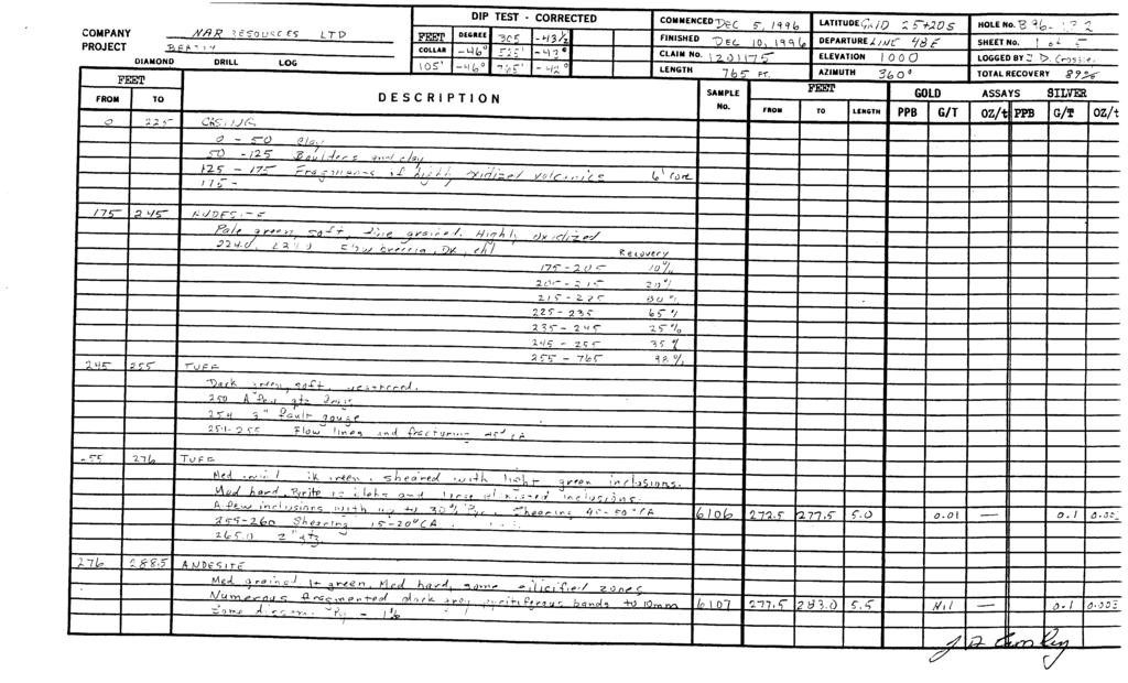
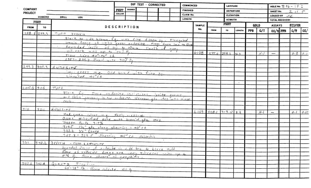
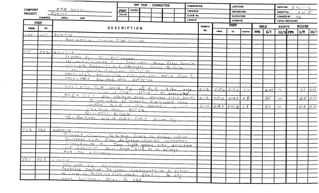
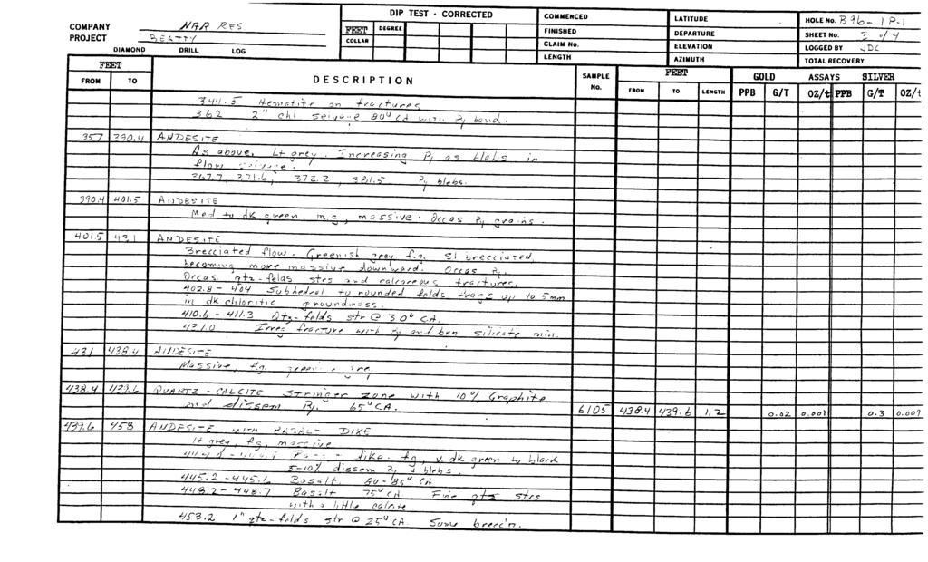
2 SHORT FORMS FOR DRILL LOGS aim alteration fractg fracturing sil siliceous approx approximate (ly) frags fragments sph sphalerite CA core angle ft foot or feet str stringer carb carbonate HC1 hydrochloric acid sub-// sub-parallel cm centimeter(s) incl inclusions vf g very fine grained eg chl ct cyp dissem dk felds course grain chlorite contact chalcopyrite dissemminated dark feldspar It mg mm occas pb po py light medium grain millimetre(s) occassional galena pyrrhotite pyrite V.G. visible gold X cross (as in cross-cutting, fracturing, etc.) < less than > more (greater) than 9fc percent " inch - inches fg fine grained qtz, qutz quartz frac fracture qv quartz vein
 DESCRIPTION oz/tjppb [c/g oza g, - c* r~ee~)\ f r \ j,-ii.hr- -\"^\" K l 'i^ r'g / ^ ^ A ;^ S\"ca 1-1?^ g y -(2 'A \".?^^ sf^ (O r^^ra. 1^2.")
3 DIP TEST - CORRECTED DECREE COMMENCED^ LATITUDE y 4 j. FINISHED CLAIM NO. i \ q p ^ 7~ LENGTH ' DEPARTURE 3-2-f tyo UL) DESCRIPTION oz/tjppb [c/g oza g, - c* r~ee~)\ f r \ j,-ii.hr- -"^" K l 'i^ r'g / ^ ^ A ;^ S"ca 1-1?^ g y -(2 'A ".?^^ sf^ (O r^^ra. 1^2. Q y^, u j^jt^ - i L;,- rt T^ 3 T-^ q^o.i -?.r6. y io7u T?U bo" ^A J 5*^1 l^oa'^ -5 M

4 FINISHED CLAIM No LENGTH DESCRIPTION
5
6

7
8

9 FROM f-% 9. /S fi R IKOUK** 13 IT o. TT V DIAMOND DRILL LOG FEET TO 1 6?. f Aw D? S ire DES METRES COLLAR DIP DEGREE C R 1 PT 1 0 TEST - -D ^0Oj n t s H f t) l OiJ f"1 T- *T v*2 v* S i l C? 0 U S Od M *7 rz (C 1? / h 7~fv i n -r ^ ^* * (Vr s -. C *1 om tr ^^-H-*?^,/ PO Q^,v^ C-7T.r 1 M e? - C -rtr-g 3 C* a C A N CORRECTED COMMENCED FINISHED CLAIM No. LENGTH SAMPLE No. FEET LATITUDE DEPARTURE ELEVATION AZIMUTH FMOH TO LENGTH HOLE No. B "((a- \ P 2. SHEET No. f, g f- S" LOGGED B Y J T) C. TOTAL RECOVERY GOLD ASSAYS PPB G/T Cu N; i bdl ^ 6^-d /Q KJD?S (Tt A? f-'-ofri r/of-r/^. /O rctf 5?o ^/P/D Art-i. i k n?. r cj4-, - ^-4 t? l"?i. "? 2- ^ T~J, - c Art -e-// (? \J t \ ^ 70 V -1 }~y p f A ^.'ti. p \ l blo lo^{ A NJDb 5 ir.r Gvf.*/ - ^ r-^f *A f- o \J "^ \\\ C i\ 4-f u y f /i A /^ X) 6-, (5* (^^" ci c; ^?, Odol of 2. ^-/x- XujT-f-U rk ^ ra ^. J?i- ac 4w*es 5"^r ^ kb ~7 ~7(a C 7 ^r /4 ^Tie^ ITS- - -P,, i nuy tp ^. 'R^rtLJlT, pc w J l "h IT-* o f- -P c ( C* ^O *S\ f C, (5 t^ cv/ ^-fz.- f"cf ^ t, -f?!! l \y, -o i T i r (0 4 u c. P j -7^/c-, o. w r 7 /^r- fvy/-, A/ /-OifT ^ Oti-4H/ - s? ir -i'tf-nx' fe/p/7* -r^/^a n ; n (5c(o/ P,, ^ r/* y y /^ ;. v- - J r^r,- -C/^vCU *7 ^, ^ (3 y Vi? ^ i l a - x' ~-- O ^fip/sl sl s*,) i- j rg Act 0 /i -' ;y/^ x 75/C1 1 il(-/ t J C, i A^^ C &I2. c " 5 ; Z c -' 5^ ^ LOCfy-nOrf,~ A, -P pro x J ^^^ourir x x rr " v ^7- ^yl /&S-7- ^X Cf/v / ~2 d) x i -7 Z~p^

10

11 FEET FROM TO L 3 t- DECREE COLLAR H? fi, rr DESCRIPTION DIAMOND DRILL LOG DIP TEST - CORRECTED COMMENCED FINISHED CLAIM No. LENGTH SAMPLE NO. LATITUDE DEPARTURE ELEVATION AZIMUTH FEET HOLE NO. g SHEET No. LOGGED BY J TOTAL RECOVERY GOLD ASSAYS SILVER olio^\4iv met "id 7 R " 1 1 f- l \ 248 A K] "D F" ff IT" IX s.sto v\-f"l ~ "Z7- 'A ~ -2 l l "2. - S. V 7, 4 -? Llft? -,' f. 9 /) f, J TNp*;,.-^ A^ a ~ *r.. ^[^^ f- \ Y\ -f Z rf - ^ ^ 6^?, ^~ T w r.o r. t? 2. o- Mr/ ys d- 1 3^ r A w ~b p*; ; -r f^ \JT e. ac i t -^n -e ^ i/^-? 0 L,. -T a*"? A M "DPS (Tff fa* -3S^\j '-*.j \ i-\i (7 Yid ^t
12

13 DESCRIPTION CORRECTED -l^ COMMENCED FINISHED CLAIM No. LENGTH SAMPLE NO. FROM I LATITUDE DEPARTURE ELEVATION AZIMUTH "BET TO LENGTH HOLE NO. g 0( 4,^ SHEET No. LOGGED BY TOTAL RECOVERY p. j ^ d-/ 'V J TX ^^^^^ GOLD ASSAYS SILVER PPB G/T OZ/t G/T oz/- 'Y3 y J vi kj x S- A ^S~a rn f ^ (l?* l* f r i J tr- 0 C ^ ^ ///n^ y- ea /^/'v^ ^ ait 5S(*r*t Po. T T^OW y/c; a 7^ 5 ^^ r k Is* c/ ^/f-e -fisc f TV r f -fi/iiv*;. ro^.u d -hz, ' ^V t^.-fk fa/*;* /,lg^c. fk rk ^' 2 CA1 2-6)^ 11 ^^ Cvl f)c(cf S, /^q v K/ o^/e-l -//Puy S.,, /^ XL z s j-f r* Z/!*VlC 7^/ Du ^//J^^- (3 H e"7 k) r* t C r? X X^

14 NfiK * --s
4771 j 6425Z2 772550^,7255,1 772S52 jv-i.-:--.* c^(p) JSra L714773")
15 L. l L. 6I8S2I j MkF. M.R.O. MJ3.0. L. j L ! M F M.R.O. 57I&47 l ) M.W.O. l L.II092)! l P P L. j L j I 8C2297 l O23O7 ( ) J J L ISff 89 Pa in k ill* r" I 8O23OI l 2183 L O B IOI. 787JO2 r87l JC )4771 j 6425Z ^,7255,1 772S52 jv-i.-:--.* c^(p) JSra L714773
16 Ont.-ino I.I'M",liy (.'l K'jrlhi.'rr.' D,ind Mines Report of Work Conducted After Recording Claim Mining Act 1 f.li 1 ' -l'! t,n MiMl'bf'l ioq -; Personal iiid"naiioo collected on this toim is ootatied under the authority of she MinTg Aci This information will be useu lor correspondence Questions about ihis collect or- should be directed to the Provincial Manager. Mining Lands. Mimsfy ol Northern Development and Mmes. Fourth Floor. 1S9 Qedar Street. Sudbury. Or'a'io. P3E 6A r ' "~"" '"~" """ Instructions: - - Reft Ree - A st 42A09SW0146 W BEATTY 900 issessment work or consu - A sketch, showing the claims the work is assigned lo, must accompany this form. j MAR REsources Ltd., Address P.O. Box 6, Suite 710, 1 First Canadian P lace, Toronto, Ont. M5X 1A9 Larder Lake Daias Waik Per^orrnec! Beatty Township. From To ftoventer 1st, 1996 ^...^.^... J^ber 31,J996 Work Performed ( Check One Work G r oup Only) Work Group ;..., ,... x ; Geotechnical Survey DianpnriDrilHng : ; Physical Work.! Including Drilling Type ^No l "vi"or G PJan'No!. - ^ l j ( Rehabilitation ; ] Other Authori/orf ' i Work j Assays Assignment from Reserve Total Assessment Work Claimed on the Attached Statement of Costs S ^SB.5 k./ r j V Note: The Minister may reject for assessmenl work credit all or part o l t he assessment work submitted if the recorded holder cannot verify expenditures claimed in the statement of costs within 30 days of a request for verification Persons and Survey Company Who Performed the Work (Give Name and Address of Author ol Report) Name. Address URI Drilling Swastika Laboratories Mel Rermick Dan Crossley (attach a schedule if necessary). Suite 420, IHRicrmond St, W., Toronto, Ont. r^h 264 ;P.O. Box, Swastika, Qrrt, POK 1TO ; 234 Donlea Dr., Toronto, Ont. WG 2N2.lJ560J^ng Vaughan,Rpad, Maple, Ont., L6A 2A7 Certification of Beneficial Interest ' See Note No. 1 on reverse side , "Date "" l conify thai al She lime Ihe work was performed, the claims covered m this work, ' report ivf?'e recorded in ifie cur'ent holder's name ot held under a beneficial interest ' l by Ihe current -ecorded holder i Jan. 8/97 Recordefl Hoider or Agenl (Signatuie) Certification of Work Report l certify that l have a personal knowledge ol the 'acts set lorth in this Work report, having performed the work or witnessed same during and/or -f o its complei'on and annexed 'eport is Irue Name and Acdress di Person Certi*V'ng "' " Michel Lafrance, Director, P.O. Box 6, Suite 710, 1 j[irst Canadian Place, Toronto, Ont. M5X 1A9 te^epone No 1Sat 8 l ""^~^~^.. Cortilied By l Recorded ~ Daij(flBcoTdBd. Notice tor Amandrrrints Sanl IP8 : \f ZB/91/ 10 6frZOlS89lfr
17 . M 7 '/tj c. J C 1 '., 't- t^z s ' a 1*?? it i5 g-^ " a si li** s ^ L. *- - \, ' ^., -L1 -. r^ o S r M ~' o -r* -\ k o^ YE ^ g ^r S ~ *J -C. t K) l.. ft" m S r- Tl i. ^ "1- V/J INJ 1... i ^ uo g ^. Q If st li cq f /1 J 5. "T" I! CT- J- *- 'J-1! ^ 5^5* i ~! s ""S c t. --1 g. E is jco CO ho S o l- en -c* Ol S? 9 2 o 3 -^ lex -s-, T Crediis you are clairninq m this 'eucrt -nay be cut back In order le minimize the adverse effects of such deletions, please indicate Irorn which claims you wish to pnonze the deletion ol credits. Please mark ^-j one of the following: 1 Credits are to be cui back starting with the claim listed last, working backwards j 2 C redits are to be cut back equally over alt claims contained in ihis report ol work. 3,. Credits are to be cut back as priorized on the attached appendix. in Ihe event that you have noi specified your choice ol priority, option one will be implemented. Note l: Examples of beneficial Interest are unrecorded transfers, option agreements, memorandum of agreements, etc., with respei to the mining claims. Nole 2: If work has been performed on patented or leased land, please complete the following: l certify thai the recorded holder had a beneficial interest in Ihe patented or leased land at Ihe lime Ihe work was performed. Signature Date 198 qor /6/91MO 617/019891*7 :Aq j
18 (S? Ontario Ministry of Nortbern Development and Mines Ministere du Developpement du Nord et des mines Statement of Costs for Assessment Credit Etat des couts aux fins du credit devaluation Transaction No.IN 0 de transaction - L - L i..-'. f/ Mining Act/Loi sur les mines Personal information collected on this form is obtained under the authority of the Mining Act. T his information will be used to maintain a record and ongoing status of the mining claim(s). Questions about this collection should be directed to the Provincial Manager, Minings Lands, Ministry of Northern Development and Mines, 4th Floor, 159 Cedar Street, Sudbury, Ontario P3E 6A5, telephone (705) Les renseignements personnels contenus dans la presente formule sont recueillis en vertu de la Loi sur les mines et serviront a tenir a jour un registre des concessions minieres. Adresser toute quesiton sur la collece de ces renseignements au chef provincial des terrains miniers, ministere du Developpement du Nord et des Mines, 159, rue Cedar, 4e etage, Sudbury (Ontario) P3E 6A5, telephone (705) Direct Costs/Couts directs Type Wages Salaires Contractor's and Consultant's Fees Droits de I'entrepreneur et de I'expertconseil Supplies Used Fournitures utllisees Equipment Rental Location de materiel Description Labour Main-d'oeuvre Field Supervision Supervision sur le terrain Type Diamond Drilling Assaying Claiming S hole spotting Type Field Office Map 8 printing Type Cove Shack Amount Montan! 2, , , Total Direct Costs Total des couts directs Totals Total global 5, , , Indirect Costs/Couts indirects * * Note: When claiming Rehabilitation work Indirect costs are not allowable as assessment work. Pour le remboursement des travaux de rehabilitation, les couts indirects ne sont pas admissibles en tant que travaux d'evaluation. Type Transportation Transport Food and Lodging Nourriture et hebergement Mobilization and Demobilization Mobilisation et demobilisation Type Vehicles Description Hotel, meal, etc. Amount Montant , Sub Total of Indirect Costs Total partiel des couts indirects Amount Allowable (not greater than 20"7o of Direct Costs) Montant admissible (n'excedant pas 20 W des couts directs) Total Value of Assessment Credit Valeur totale du credit [Total of Direct and Allowable d'evaluation Indirect costs) (Total des codls directs et indlrects admissibles Totals Total global , , , Note: T he recorded holder will be required to verify expenditures claimed in this statement of costs within 30 days of a request for verification. If verification is not made, the Minister may reject for assessment work all or part of the assessment work submitted. Note : Le titulaire enregistre sera tenu de verifier les depenses demandees dans le present etat des couts dans les 30 jours suivant une demande ci cet effet. Si la verification n'est pas effectuee, le ministre peut rejeter tout ou une partie des travaux devaluation presentes. Filing Discounts Remises pour depot 1. Work filed within two years of completion is claimed at o of the above Total Value of Assessment Credit. 2. Work filed three, four or five years after completion is claimed at 50 07o of the above Total Value of Assessment Credit. See calculations below: 1. Les travaux deposes dans les deux ans suivant leur achievement sont rembourses ci 100 "/o de la valeur totale susmentionnee du credit d'evaluation. 2. Les travaux deposes trois, quatre ou cinq ans apres leur achievement sont rembourses a 50 "/o de la valeur totale du credit d'evaluation susmentionne. Voir les calculs ci-dessous. Total Value of Assessment Credit Total Assessment Claimed x 0.50 = Valeur total* du credit d'evaluation x 0,50 = Evaluation totale demandee Certification Verifying Statement of Costs Attestation de l'etat des couts l hereby certify: that the amounts shown are as accurate as possible and these costs were incurred while conducting assessment work on the lands shown on the accompanying Report of Work form. J'atteste par la presente : que les montants indiques sont le plus exact possible et que ces defenses ont 6te engagees pour effectuer les travaux devaluation sur les terrains indique's dans la formule de rapport de travail ci-joint. thatas Director (Recorded Holder, Agent, Position in Company) to make this certification. l am authorized Et qu'a litre de je suis autorise (titulaire enregistre, representant, poste occupe dans la compagnie) a faire cette attestation. Signature Date Jan. 8, (04/91) Nota : Dans cette formule, lorsqu'il designe des personnes, le masculin est utilise au sens neutre.
![l NOTES Coulson Twp. (M 340) 400' Surface Rights Reservation along the shores of all lakes and rivers. fftre Hi^ HeS^Pv-sp L YflKjMb" ffiufl 4168 ' 2 ffi. i] L - e*ta ftlgnul:as-!-. -.- L. l L.](/docs-images/94/119678238/images/19-0.jpg "28888 i 2188?")
19 l NOTES Coulson Twp. (M 340) 400' Surface Rights Reservation along the shores of all lakes and rivers. fftre Hi^ HeS^Pv-sp L YflKjMb" ffiufl 4168 ' 2 ffi. i] L - e*ta ftlgnul:as-! L. l L i 2188? VI NOTICE OF FORESTRY ACTIVITY TN8 TOWN8MT l AREA FALLS WJTHW THE WHTAMAfl MANAftCMEMr UNT, AND MAY BE SUBJECT TO Fonerrm- OPERATCON^ THE MM VJNTT TORfBTEK FOR THB AMEA CAN BE CONTACTED AT: POBQKIBt tmmtka, ONT. POKITO lot \syr i r w j w MINING RIGHTS WITHDRAWWOM STAWNC, PROSPECTING, SALE OR LEASE, SECTION 3S, THE MINING ACT, RSO 1990 W-L-22/96 NER 1-. l L. jam! 822*28-10 ro ro 7B7IOI 7B71O2 L flos j CD fe DATE OF ISSUE MAY 9 LARDER LAKE IWG RECORDER'S OFFICF THE INFORMATION THAT APPEARS ON THIS MAP HAS BEEN COMPILED FROM VARIOUS SOURCES, AND ACCURACY IS NOT GUARANTEED. THOSE WISHING TO STAKE MIN ING CLAIMS SHOULD CON SULT WITH THE. MINING RECORDER, MINISTRY OF NORTHERN DEVELOP MENT AND MINES, FOR AD DITIONAL INFORMATION ON THE STATUS OF THE LANDS SHOWN HEREON. o. 5 H o vy/ 7 LJM X (- ' ^i 4 l l l. 77*2551 [^5648 f - ~r\:~ Q. LEGEND LEASED FOR MNNO MOHTS ONLY PATENTED LAND PATENTED FOR SURFACE RIGHTS ONLY LEASE LICENSE OF OCCUPATION CROWN LAND SALE LOCATED LAND CANCELLED MINING RIGHTS ONLY SURFACE RIGHTS ONLY HIGHWAY ft ROUTE Ne. ROADS TRAILS F.WAYS POWER l Id -' MARSH OR MUSKEG MINES *u(8d only with tumrnar rtiort.icotiont or whin space IsllmiUd. CM 4TNo. TOWNSHIP OF ^N -4\g iff^t. r^ n ' BASt LIME CON l IN BEATTY TWP THE BED OF FROOME LAKE IS CLOSED TO STAKING Hislop Twp. (M.355) ' ^6^320/ appron. CIRCULATED NOVEMBER V BEATTY DISTRICT OF COCHRANE LARDER LAKE MINING DIVISION SCALE: l INCH s 40 CHAINS(1/2MILE) DR. k. k. M. 324 DATE Oal/71 PLAN No. ONTARIO DEPARTMENT OF MINES AND NORTHERN AFFAIRS ARCHIVED JA^
20 q***** : u* d* A'o. VIA #f SOURCES IT P g ^4 ihy Ttu a, 13 f *-/// y loo 42A09SWD146 W97B BEATTY 210
21 -/ae f e* t ft \- ft J n ^ f* p ^ f 1* y ~*- **fr - ^ ft ;*! y"sav 42A09SW0148 W9780.Q0024 BEATTY 220? i (06
RECEIVED. for Sharpmin Developments Incorporated FEB Geologist January 4, 1996 Toronto, Ontario MINING LANDS BRANCH
 31F06NE0001 2 164OO SEBASTOPOL 010 Analytical Results for Apatite Samples from Turner's Island, Island 'D', Mining Claim SO 1150877, Sebastopol Township, Renfrew County, Southern Ontario Mining Division
42AeSNEeSe GODFREY ASSESSMENT WORK FOR RICHARD MATHIEU ON THE GODFREY TOWNSHIP PROPERTY TIMMINS, ONTARIO RECEIVED MINING LANDS BRANCH
 42AeSNEeSe7 2.14685 GODFREY 010 ASSESSMENT WORK FOR RICHARD MATHIEU ON THE GODFREY TOWNSHIP PROPERTY TIMMINS, ONTARIO RECEIVED AUG13 1992 MINING LANDS BRANCH PROSPECTING WORK (a) CLAIM LOCATION Area:...
Lost nine Property Assessment Work Report Van Horne Township ( Kenora Mining Division
 52F10NW2001 2.20035 VAN HORNE 010 Lost nine Property Assessment Work Report Van Horne Township ( Kenora Mining Division Wm. J. Sovereign 103 Wabigoon Drive Dryden, Ontario P8N 1W4 January 22, 2000 TABLE
31L11NW MCAUSLAN 010 A REPORT ON A RECONNAISANCE GEOLOGY SURVEY PROJECT
 31L11NW9557 2.15064 MCAUSLAN 010 2. 15064 A REPORT ON A RECONNAISANCE GEOLOGY SURVEY PROJECT IN MCAUSLAN TOWNSHIP, ONTARIO FOR CENTRAL ONTARIO NATURAL STONE COMPANY LIMITED,o RECEIVED JUN l 5 1993 MINING
Magnetometer Survey on the
 42E13NE8400 2.15192 CASTLEWOOD LAKE 010 Magnetometer Survey on the FOUNDER RESOURCES INC. Conglomerate Lake Property Castlewood Area/ Ontario District of Thunder Bay Oct. 15, 1993 By: Barbara Kowalski
Post. Claim E.O D.D.Hole \ L ength 243' Bearing N.52 U W, Dip 45 0 AXT core BIJOU MINFS LIMITED. l" to 100' 31C15NW PALMERSTON 010
 #1 Post Claim E.O. 460392 D.D.Hole \ L ength 243' Bearing N.52 U W, Dip 45 0 AXT core BIJOU MINFS LIMITED l" to 100' September 22, 1977 J. P. Jewell 31C15NW0019 74 PALMERSTON 010 DIAMOND DRILL RECORD PROPERTY
DDH MS Over burden 42EioNwooiow944o.ooi56ASHMORE ' qtz. carovein aampj.c nu. j. ^ Altered Dacite j
 s J Hole depth 156 Hole dip -45 DDH MS-90-2 Maw OT 1 QQfl 0-8 Over burden 42EioNwooiow944o.ooi56ASHMORE 010 8-8.8.8' qtz. carovein aampj.c nu. j. ^ 8-62.5 Altered Dacite j 11.8-12.2.4' qtz. carb along
2. i. GEOLOGY Vincent Twp., Ontario NTS 42E/12. By: Barbara Kowalski FOUNDER RESOURCES INC. 42E12NE VINCENT
 42E12NE0062 2.15658 VINCENT 010 2. i FOUNDER RESOURCES INC. GEOLOGY Vincent Twp., Ontario NTS 42E/12 September 21, 1994 By: Barbara Kowalski 42E12NE0062 2.15658 VINCENT 010C TABLE OF CONTENTS TITLE PAGE
. QOtSI. Timmins Area. Geological Report NE Eldorodo Township Property. June, 1994 D R. 42A06SE M93E DORADO "" 010
 . QOtSI 42A06SE00462 1M93E DORADO "" 010 Geological Report NE Eldorodo Township Property Timmins Area June, 1994 D R. mile Langmuir Tp. - M.292 Geological Report NE Eldorodo Township Property Timmins Area
* STUART W. DEVEAU. r '/i SEPTEMBER 1995 NTS: 52K/13 PLACER DOME CANADA LIMITED PROJECT CLAIM KRL
 S2K13NW0011 2 16217 BAIRD 010 PLACER DOME CANADA LIMITED PROJECT 413 - CLAIM KRL 1184166 GEOLOGICAL REPORT - 1995 WORK PROGRAMME BAIRD TOWNSHIP, ONTARIO NTS: 52K/13 r '/i SEPTEMBER 1995 * STUART W. DEVEAU
No other previoro work recorded on the area covered
 PROSPECTING REPORT FISHER LAKE AREA #62617 KENORA MINING DIVISION NTS52F12SE LAT. 49 34'45" to 49 35 i 45 lt north LONG. 93 30'30" to 9 3 31'45" WEST INTRODUCTION Claimsl149639-40-41-42 vere staked to
g. 14 RECEIVFH NOV l MINING LANDS BRANCH REPORT ON THE EXPLORATION CARRIED OUT ON THE MOSS TOWNSHIP PROPERTY FOR FOGEN-WING-WALLACE-CALVERT
 52B18SW8101 2.14799 MOSS 010 REPORT ON THE EXPLORATION CARRIED OUT ON THE MOSS TOWNSHIP PROPERTY FOR FOGEN-WING-WALLACE-CALVERT RECEIVFH NOV l 7 1992 MINING LANDS BRANCH by: CLAUDE LAROUCHE OVALBAY GEOLOGICAL
TOWNSHIP: ARNOLD REPORT NO; 18. Date Note Nov-Dec/87 (1) Footage 266' Notes: (1) IW , filed in August/88. WORK PERFORMED FOR: LAC Minerals Ltd
 Footage 266' Notes: (1) IW , filed in August/88. WORK PERFORMED FOR: LAC Minerals Ltd") 32DMNWW2, 16 ARNOLD 010 DIAMOND DRILLING TOWNSHIP: ARNOLD REPORT NO; 18 WORK PERFORMED FOR: LAC Minerals Ltd RECORDED HOLDER: Same as Above [xx] : Other [ ] Claim No. L 884017 Hole No. A14A Footage 266'
32DMNWW2, 16 ARNOLD 010 DIAMOND DRILLING TOWNSHIP: ARNOLD REPORT NO; 18 WORK PERFORMED FOR: LAC Minerals Ltd RECORDED HOLDER: Same as Above [xx] : Other [ ] Claim No. L 884017 Hole No. A14A Footage 266'
BLACK PEARL MINERALS INC.
 52F07SE0008 2.16968 MEGGISI LAKE 010 BLACK PEARL MINERALS INC. GEOPHYSICAL SURVEYS «SUNSHINE LAKE PROPERTY» Octobre 1996 «* TABLE OF CONTENTS I - INTRODUCTION P. 1 II - PROPERTY P. 1 III - LOCATION & ACCESSIBILITY
ZENMAC METAi, MINES LIMITED. SCHHKIBEK, ONTnHlO. PURVEY OK THE NI'COPOR PROPERTY
 63.2625 PAYS PLAT LAKE 010 ZENMAC METAi, MINES LIMITED SCHHKIBEK, ONTnHlO. PURVEY OK THE NI'COPOR PROPERTY IS'iRODUCTIQM The property, about 6 miles north of Schreiber, has been held by various people
Within. Mineral Claim
 31E12SE2001 2.19268 RYERSON 010 2.19-68 January 15,1999 ASSESSMENT REPORT ON A GEOLOGICAL MAPPING PROJECT Within Mineral Claim 1077246 Ryerson Township, Southern Ontario TABLE OF CONTENTS 1. Summary And
52AieNE8iei MCTAVISH
 C 52AieNE8iei 63.6201 MCTAVISH 010 r - A. rf T able of Contents 52AiaiNE8lei 63.6281 MCTAVISH Introduction..............................,.......,.. 1 Location Map.........................................
y^ cjc-o-4-o^v*, O cx S oj X o 5 \ J * X -*-oj *O *^l vxyvx^v^s- ' o r^. OO*JLc 52N07SVMW26 OPO2-10S SKINNER
 5N07SVMW6 OPO-10S SKINNER i\ r^. OO*JLc ' K. vxyvx^v^s- \ J *^l * X -*-J *O O cx l X 5 S J y^ cjc--4-^v*, I. c/ ^ f hi *r M, fu ^ r^ vp p P v ^ r?ur' f R Hi?f r^lrtf r H ^ i? f * r j pir f ^t-? ^ f ^ f,
DIAMOND DRILLING NOTES: 1. W , filed July 19/93. TWyARKA Scapa REPORT NO. WORK 1'KUKOIIMKD l.\)i^oranda Ex P loration Co - Ltd -
i^oranda Ex P loration Co - Ltd -") 3aE04SW934B l SCAPA 00 DIAMOND DRIING TWyARKA Scapa REPORT NO. WORK 'KUKOIIMKD l.\)i^oranda Ex P loration Co - td - RKOORDKn HOUWIl: SAME AS ABOVE f X l : OTHER! j CIAIM NO. 590 HOK NO. SC-90- FOOTAGE
3aE04SW934B l SCAPA 00 DIAMOND DRIING TWyARKA Scapa REPORT NO. WORK 'KUKOIIMKD l.\)i^oranda Ex P loration Co - td - RKOORDKn HOUWIl: SAME AS ABOVE f X l : OTHER! j CIAIM NO. 590 HOK NO. SC-90- FOOTAGE
Castlewood Lake Map Area (6-22) Thunder Bay Mining District, Ontario
 Thunder Bay Mining District, Ontario") 42E3NEee87 2. M469 CASTLEWD LAKE 0 REPRT N THE 99 EXPLRATIN F THE LASSILA CN LAKE PRPERTY Castlewood Lake Map Area (6-22) Thunder Bay Mining District, ntario Date: January 992 By: P. Lassila 42E3NE8M7
42E3NEee87 2. M469 CASTLEWD LAKE 0 REPRT N THE 99 EXPLRATIN F THE LASSILA CN LAKE PRPERTY Castlewood Lake Map Area (6-22) Thunder Bay Mining District, ntario Date: January 992 By: P. Lassila 42E3NE8M7
Assessment Report by the Canadian Nickel Co. Ltd. Magnetometer Survey. Larder Lake Mining Division Lebel Tovnship, Ontario
 32084Nwea67 2.331* LEBEL 010 Assessment Report by the Canadian Nickel Co. Ltd. Magnetometer Survey Larder Lake Mining Division Lebel Tovnship, Ontario Claims L-531657 L-531658 L-531111 Map No.: M-359,
We are committed to providing accessible customer service. If you need accessible formats or communications supports, please contact us.
 We are committed to providing accessible customer service. If you need accessible formats or communications supports, please contact us. Nous tenons à améliorer l accessibilité des services à la clientèle.
Ontario. Strathy Township Temagami Area Sudbury Mining Division. Driffield Cameron GROUND ELECTROMAGNETIC SURVEY PENROSE NORTH PROPERTY.
 l J1MO4SW0153 2 16336 STRATHY 010 GROUND ELECTROMAGNETIC SURVEY PENROSE NORTH PROPERTY Strathy Township Temagami Area Sudbury Mining Division Ontario Driffield Cameron January 5, 1996 r*, t 31MCWSW01S3
4. Geological maps published by the Ontario Department of Mines.
 52J08NWei45 S2J08NWa6B1 SMYE 010 AMALGAMATED RARE EARTH MINES LTD. *, SAVANT LAKE PROSPECT x ONTARIO INTRODUCTION t This Is a report on a group of 28 claims control led by Amalgamated Rare Earth Mines
RECEIVED GOLD PROPERTY REPORT ON THE 1992 EXPLORATION OF THE LASSILA-HOUGHTON ELMHIRST TWP. MINING LANDS BRANO NTS 42E/13.
 42E13SE0603 E.14999 ELMHIRST 010 1499 REPORT ON THE 1992 EXPLORATION OF THE LASSILA-HOUGHTON ELMHIRST TWP. GOLD PROPERTY NTS 42E/13 Latitude 490 50* Longitude 870 21' Date: December 1992 By: P. Lassila
XRAL X-RAY Bharti Engineering Associates Inc Lasalle Blvd. P O Box 2336 Sudbury (M P3A4S8. DATE SUBMITTED 9-Aug-89
 XRAL X-RAY 1885 LESLIE S TEL: (416)445 41113SE9429 2.12731 ULSTER 010 C ERT X F X O A.T E TO: BHARTI ENGINEERING ASSOCIATES INC. ATTN: HAROLD J. TRACANELLI 1009 LASALLE BLVD P.O. BOX 2336 SUDBURY, ONTARIO
Toronto, Ontario November 16, This report may not be reproduced, in whole or in part, without the written permission of Derry, Michener S Booth.
 13 2.1354 L ITTLE 010 GEOPHYSICAL SURVEYS, LITTLE TOWNSHIP CLAIM GROUP OB-F TIMMINS AREA PORCUPINE MINING DIVISION, ONTARIO Toronto, Ontario November 16, 1973 This report may not be reproduced, in whole
PROSPECTING REPORT THE WALLACE CLAIM OMENICA MINING DIVISION. 54" x6" 3.d d. for. Reako Exlorat ions Ltd. Wallace Rev. C.G.
 PROSPECTING REPORT ON THE WALLACE CLAIM OMENICA MINING DIVISION 54"44 14 1x6" 3.d d by David A. Howard P.Eng. for Reako Exlorat ions Ltd. Claim Locat ion Wallace Rev. C.G. #1560 Dome Mountain Area 9 3
REPORT OF MAGNETOMETER SURVEY ON TB RICKABY 8 LAPIERRE TOWNSHIPS THUNDER BAY MINING DIVISION THUNDER BAY, ONTARIO RECEIVED
 42E14SW0017 2.15545 LAPIERRE LAKE 010 REPORT OF MAGNETOMETER SURVEY ON TB1196017 RICKABY 8 LAPIERRE TOWNSHIPS THUNDER BAY MINING DIVISION THUNDER BAY, ONTARIO 2.15545 RECEIVED AUG 2 9 1994 ' MINING UkNDS
WORK PERFORMED FOR: * FOSTER MARCHALL
 31M13SE0024 23 INGRAM DIAMOND DRILLING 010 TOWNSHIP; INGRAM REPORT NO: 2 3 WORK PERFORMED FOR: * FOSTER MARCHALL RECORDED HOLDER: SAME AS ABOVE : OTHER l J CLAIM NO. HOLE NO. FOOTAGE DATE NOTE L822224
A L A BA M A L A W R E V IE W
 A L A BA M A L A W R E V IE W Volume 52 Fall 2000 Number 1 B E F O R E D I S A B I L I T Y C I V I L R I G HT S : C I V I L W A R P E N S I O N S A N D TH E P O L I T I C S O F D I S A B I L I T Y I N
010 BAND - ORE RESOURCES LTD. ROSS PROPERTY. Penhorwood Township, Ontario Porcupine Mining Division NTS: 42B/1
 42B01NE0049 2 16729 KENOGAMING 010 BAND - ORE RESOURCES LTD. ROSS PROPERTY Penhorwood Township, Ontario Porcupine Mining Division NTS: 42B/1 REPORT ON GROUND MAGNETIC SURVEYS November 30th, 1995 o ROBERT
Claim NQ. Hole NO. Footage. Date. Note. Diamond Drilling. Notes: 300' T. B M Feb/73 307' T. B Feb/73 F-3 T. B.
 42E15NE8081 16 BICKLE 010 Diamond Drilling Township of Bickle Report NQ; is Work performed by: Hudson Bay Expi. e Dev't Co. Ltd, Claim NQ Hole NO Footage Date Note T. B. 33892M- 6 338925 F-l 300' Feb/73
on the Diamond Drilling done on the LAKESIOE GROUP of Mineral Claims SLOCAN MINING DIVISION 82-F-14-W Long ' Lat '
 Assessment Work Report on the Diamond Drilling done on the LAKESIOE GROUP of Mineral Claims SLOCAN MINING DIVISION 82-F-14-W Long 117 22' Lat. 49 58' ADRIAN KESLER SILVERTON, B.C. operator LEVON RESOURCES
fe JAMES LAKE PROPERTY BEST TWP. HORIZONTAL LOOP ELECTROMAGNETICS GEOPHYSICAL SURVEY by: David Laronde 31M04NE001S BEST
 fe. 15449 31M04NE001S 2 15449 BEST 010 JAMES LAKE PROPERTY BEST TWP. HORIZONTAL LOOP ELECTROMAGNETICS GEOPHYSICAL SURVEY FEBRUARY 1994 by: David Laronde HUH 01OC Table of Contents 1.0 Introduction 2.0
Saroplo Interval. to to
 PQ'WER OPTION RESAPLING 2.34 EEN LAKE E-6- Sample j P 4 P 42 P 43 P 44 P 45 P 46 P 4 P 4 P 4 P 4 P 4 P 42 P 43 P 44 P 45 P 46 P 4 P 4 P 4 P 420 P 42 P 4 P 423 P 4 P 4 P 426 P 42 P 42 P 42 Saroplo Interval
SELCO EXPLORATION COMPANY LIMITED
 --..-..-...-.....l.iibibiiiiiiiiiiiiiii II III S2J16NW9001 52J16NW0014A1 PASHKOKOGAM LAKE 0 10 SELCO EXPLORATION COMPANY LIMITED GEOPHYSICAL REPORT CLAIMS 200696 TO 200707 PATRICIA MINING DIVISION August
DIAMOND DRI 42A12SW BANNOCKBURN 010. CLAIM No, HOLE No, FOOTAGE DATE NOTE. TOWNSHIP: Bannockburn REPORT No,:
 DIAMOND DRI 42A12SW0336 16 BANNOCKBURN 010 TOWNSHIP: Bannockburn REPORT No,: WORK PERFORMED BY: Petromet Resources Ltd. CLAIM No, HOLE No, FOOTAGE DATE NOTE L 571405 84-1 84-2 310 224 Dec/84 Dec/84 (D
Jess Lake Mackelcan Twp. -90 degrees
 FROM : PGEOPH1L FflX NO. : 757521123 Nov. 19 23 1:7PM PI Flag Resources: Hole no: Location: Claim no: Depth: Core size: Core stored: Dip: tarted: Finished: Core logged by: Jess Lake Mackelcan Twp JL-3-8
Developpement economique Canada Economic Development Canada. A l v I E R I C A N A I R E S I N C.
 1*1 I n n o v a t i o n, S c i e n c e s e t I n n o v a t i o n, S c i e n c e a n d Developpement economique Canada Economic Development Canada Office de la propriete intellectuelle du Canada Canadian
DIANOND DRILLING REPORT. NICOLA MINING DIVISION, B.C. Lat 'N, Long. 12O03O'W N.T.S. Map 921/1 W82E. for
 W DIANOND DRILLING REPORT MM #1, MM #2, MM #3, INEZ #1, INEZ #2, AND CROWN GRANTED CLAIMS NICOLA MINING DIVISION, B.C. Lat. 50 10'N, Long. 12O03O'W N.T.S. Map 921/1 W82E for FLAIR RESOURCES LTD. 1417-409
SUPPLEMENT TO MAGNETOMETER 6 ELECTROMAGNETIC SURVEY REPORT. DATED NOVEMBER l, 1973 CIGLEN INVESTMENTS LIMITED CLAIMS GROUP BAD VERMILLION LAKE AREA
 ^ A R l ^ 1974 010 PROJECTS UNIT SUPPLEMENT TO MAGNETOMETER 6 ELECTROMAGNETIC SURVEY REPORT DATED NOVEMBER l, 1973 CIGLEN INVESTMENTS LIMITED CLAIMS GROUP BAD VERMILLION LAKE AREA DISTRICT OF RAINY RIVER
John A. Wakeford Noranda Exploration Co., Ltd, November 4, 1980 rinnnins, Ontario
 42CC1NEfc4e9 801101 ECHUM 010 " ' i-^y&sg?' '.. -.r. K;VW\\:.!^-*.]-^--'^-r-r^Pj^Q..-. ;,: v 1,;-'-,..- ^^-^^^^ysr-r^ijjfiv^jj. v -." ". '. ' "i - '' '. '':.;': s.'.ilv'., p...--'*l r-j@tw IP ^vt'.'v*:-^
RECEIVED APR NELSON GRANITE 1997 STRIPPING AND BULK SAMPLING PROGRAM FORGOTTEN LAKE CLAIM BLOCK. Forgotten Lake Area
 52L01SW2001 2.18578 FORGOTTEN LAKE 010 NELSON GRANITE 1997 STRIPPING AND BULK SAMPLING PROGRAM FORGOTTEN LAKE CLAIM BLOCK Forgotten Lake Area NTS: 52L/1SW Kenora Mining Division 2.18578 2.1839 RECEIVED
DATE NOTE V73' WORK PERFORMED FOR; Cominco Ltd. RECORDED HOLDER: SAME As ABOVE [x] : OTHER [ 3 CLAIM No, HOLE No, FOOTAGE DUO ND DRILLING
![DATE NOTE V73' WORK PERFORMED FOR; Cominco Ltd. RECORDED HOLDER: SAME As ABOVE [x] : OTHER [ 3 CLAIM No, HOLE No, FOOTAGE DUO ND DRILLING](/thumbs/88/117580828.jpg "DATE NOTE V73' WORK PERFORMED FOR; Cominco Ltd. RECORDED HOLDER: SAME As ABOVE [x] : OTHER [ 3 CLAIM No, HOLE No, FOOTAGE DUO ND DRILLING") DUO ND DRILLING 42AieSWe308 30 MATHESON 010 TOWNSHIP: Matheson REPORT No: 30 WORK PERFORMED FOR; Cominco Ltd. RECORDED HOLDER: SAME As ABOVE [x] : OTHER [ 3 CLAIM No, P 652569 P 652568 P 651135 P 651132
DUO ND DRILLING 42AieSWe308 30 MATHESON 010 TOWNSHIP: Matheson REPORT No: 30 WORK PERFORMED FOR; Cominco Ltd. RECORDED HOLDER: SAME As ABOVE [x] : OTHER [ 3 CLAIM No, P 652569 P 652568 P 651135 P 651132
Namex Explorations Inc. Report on Drill Holes PC & PC Post Creek Property Claim S.l , Norman Township Sudbury Mining District
 . 368 4: Namex Explorations nc. Report on Drill Holes PC - 12-06 & PC -- 13-06 Post Creek Property Claim S.l 094826, Norman Township Sudbury Mining District RECEVED DEC 1 0 =:~7 ntroduction GEOSCENCf ASSESSMENT
DOMINION GULF COMPANY 203 BAY STREET TORONTO l, ONTARIO, CANADA
 31M12SE8ai2 6 3.281 CASEY DOMINION GULF COMPANY 203 BAY STREET TORONTO l, ONTARIO, CANADA 010 E. W. WE8TRICK GENERAL AOENT IN REPLY REFER TO: February l, 1952. REGISTERED Mr. H. C. Rickaby, Deputy Minister
ASSESSMENT SUMMARY - A. SALO PROPERTY ( MCGARRY TOWNSHIP ^ NTS 32D/4. Introduction
 2. 16102 ASSESSMENT SUMMARY - A. SALO PROPERTY ( MCGARRY TOWNSHIP ^ NTS 32D/4 Introduction On May 25, 1995, Falconbridge geologist Ray Kohlsmith visited staked claims 1 187016 A 1 187017 located 500m north
Dwg. S Geological Plan and Section (Hole 93-1) showing visual X of garnet.
 showing visual X of garnet.") 31F03NW0002 W9490.00059 ASHBY 010 TABLE OF 31F03NW0002 W9490.00059 ASHBY IP DRXLLINQ 01OC On Ruby Annby Townsn -i p Agont:, R. J..A. Summary ft Recommendat i ons Results Of Drilling 1 2 APPENDIX A Diamond
31F03NW0002 W9490.00059 ASHBY 010 TABLE OF 31F03NW0002 W9490.00059 ASHBY IP DRXLLINQ 01OC On Ruby Annby Townsn -i p Agont:, R. J..A. Summary ft Recommendat i ons Results Of Drilling 1 2 APPENDIX A Diamond
t y RECEIVED This report is concerned with the results of the electromagnetic survey as applied to the following claims: l K to K
 t y 53F*4NWei37 2.1853 HERONRY LAKE 010 HUDSON BAY EXPLORATION AND DEVELOPMENT COMPANY LIMITED ELECTROMAGNETIC SURVEY OF GROUP "N" EAGLE PROJECT - KAKAGI BLOCK KENORA MINING DIVISION - ONTARIO RECEIVED
Area of COLLISHAW LAKE Report NO 19
 Diamond Drilling.....i mill l II l II11II III 53PI2NW00I5 S2PI2NW88I2E1 COLLISHAW LAKE 010 Area of COLLISHAW LAKE Report NO 19 Work performed by: Umex Corporation Limited Claim NO P 390911 Hole NQ Footage
r ffj Ronald C. Wells, BSc. Lacana Mining Corporation LACANA CLAIMS GAUTMER TOWNSMP GEOPHYSICAL REPORT OCT LARDER LAKE MINING DIVISION
 a- 32D04NWei39 2.3507 GAUTHIER 010 GEOPHYSICAL REPORT LACANA CLAIMS GAUTMER TOWNSMP LARDER LAKE MINING DIVISION RECEIVED OCT171980 MINING UNDS SECTION Author: Ronald C. Wells, BSc. Lacana Mining Corporation
RECORDED HOLDER: SAME As ABOVE [x] : OTHER [ ]
![RECORDED HOLDER: SAME As ABOVE [x] : OTHER [ ]](/thumbs/92/108372125.jpg "RECORDED HOLDER: SAME As ABOVE [x] : OTHER [ ]") DIAMOND DRILLING 4aoa9Nweei74 se PIC 010 Township: P ic Report No: 3 6 WORK PERFORMED FOR: RECORDED HOLDER: SAME As ABOVE [x] : OTHER [ ] Lytton Minerals Limited/The Ontario Paper Company Limited CLAIM
DIAMOND DRILLING 4aoa9Nweei74 se PIC 010 Township: P ic Report No: 3 6 WORK PERFORMED FOR: RECORDED HOLDER: SAME As ABOVE [x] : OTHER [ ] Lytton Minerals Limited/The Ontario Paper Company Limited CLAIM
We are committed to providing accessible customer service. If you need accessible formats or communications supports, please contact us.
 We are committed to providing accessible customer service f you need accessible formats or communications supports please contact us Nous tenons à améliorer l accessibilité des services à la clientèle
Diamond- Drill Log of Assessment Hole 200' South of north SHEET'NO. HOLE NO. l'ab94 DEPTH 203' ANQLE STP.^P- ELgVATIQKl 200' East of ANALYSIS. l.
 ! A Bayside Township THE INTERNATIONAL NIOKEL co. OF CANADA, LIMITED NE 1/4 N 1/2 Lot 2, Cone. I M..-,, 1 KI ^ orr/^r^ftr^ PROPERTY C lalm 104327 x ^-SAMPLING RECORD ^rr-r- Location Diamond- Drill Log
176 5 t h Fl oo r. 337 P o ly me r Ma te ri al s
 A g la di ou s F. L. 462 E l ec tr on ic D ev el op me nt A i ng er A.W.S. 371 C. A. M. A l ex an de r 236 A d mi ni st ra ti on R. H. (M rs ) A n dr ew s P. V. 326 O p ti ca l Tr an sm is si on A p ps
y ' 'r 0s r *^* r-f0 c c ^ /j- (jo/* -Or? 70 S' . /?* "S/*. s* ^ f O 4 vi /S& -fb tl f f jyfsjli*..f-* 1?^ /Cv/' . -
 0s r 42A11NE0079 OP91-389 TULLY 010 -Or? 70 S' (jo/* c c 77-7 7 tt G r. -. /?* "S/*. f O 4 vi /S& -fb jyfsjli*..f-* y ' 'r tl f f * s* /j- ** r-f0 /Cv/' 1? " ' ~ - - - r7 r k 1 t S 4 c x*/ N 4. *. s ~}
:^^^^.^:*^.-f.^ r--", y.;-., - :^--,.,:,-;. ^;^u;;:-4:-;:-c?\'rfe *.V. V '^-t?"' :"^4^'A^'-*""^ ::--^-*^ii^i' :'^'^
 43C88SW0176 9939 JACOBSON i ;^*X ' y-f-'v' - * - :- " v-v-vj- "'-, p,v- *.,-... ''- i,. --: ^j v i,:^ v.- ' *,..-.- x, S'J~ f;" V J *J ' :'i? "'. 'f ' -'"c,- ; i -- - -?-.-'.f ' -' ' -. '.f-,-,.~.~ -Ji-'.'-:
41O16SW MARION PROV NCE OF ONTAR. ieoscience ASSESSMENT. nmr**-
 41O16SW2005 2.22486 MARION 010. 22 4 8 PROV NCE OF ONTAR ieoscience ASSESSMENT nmr**- . MARION CLAIM BLOCK SoftMap Techndogies l ne eptesewwi by OiflDepartmefrtcf Natural Resoii'ces, and by S*M Scale 1:
QQQ-4 QQQ-3. Apr/78 Apr/78. Diamond Drilling. Claim N9 Hole NO Footage Date Note P ,0' P ' (2) Notes: (1) #132-78
 Notes: (1) #132-78") Diamond Drilling 42B01SE0018 22 PENHORWOOD 010 Township of PENHORWOOD Report NO 22 Work performed by: Geophysical Engineering Limited Claim N9 Hole NO Footage Date Note P 504953 P 504938 QQQ-4 QQQ-3 220,0'
Diamond Drilling 42B01SE0018 22 PENHORWOOD 010 Township of PENHORWOOD Report NO 22 Work performed by: Geophysical Engineering Limited Claim N9 Hole NO Footage Date Note P 504953 P 504938 QQQ-4 QQQ-3 220,0'
To test an EM conductor and provide geological information.
 Banting Township Property OPAP Final Submission 1998 DIAMOND DRILLING REPORT January 27, 1999. Objective: To test an EM conductor and provide geological information. Final results: Two holes were drilled
Notes: (1) Location sketch received November 5, 1952 (Port Arthur Mining Division),
 Location sketch received November 5, 1952 (Port Arthur Mining Division),") 42D14NWea48 11 PAYS PLAT LAKE 010 Diamond Drilling Area o f Pays Plat Lake Report NQ Work performed by: L- c- Anderson Claim NQ (a) TB 42745 Hole NQ Footage Date Note 1A 2A 3A 4A 5A 53; 62' 162' 58' 89'
42D14NWea48 11 PAYS PLAT LAKE 010 Diamond Drilling Area o f Pays Plat Lake Report NQ Work performed by: L- c- Anderson Claim NQ (a) TB 42745 Hole NQ Footage Date Note 1A 2A 3A 4A 5A 53; 62' 162' 58' 89'
Simplified exploration work report
 Simplified exploration work report Work Report of exploration and examination of outcrops of rock and boulders Report on stripping and excavating work of $ 5 000 or less.(section 81 of regulation) Report
VAN SILVER EXPLORATIONS LTD. DRILLING REPORT. April 25, h:,*.i '... ~ ;do.
 1..- \.,I ~ ;do. 4339 VAN SILVER EXPLORATIONS LTD. DRILLING REPORT April 25, 1974. I 4939......... h:,*.i '....... -1- VAll SlVfR EXPlORfITlO~S LTD. (N. P. L.) TLLCPHONL (604) 687-4150 118-615 WEST HASTINGS
MINING CLAIMS t A
 2L**NE* 2.2*38 METCALFE LAKE OO CESCRIPTION OF WORK PERFORMED ON MINING CLAIMS 3. 3. 32. 327t 3260. A 326 3 Located and cleaned out three previously excavated rock trenches* Trenches measured 00 feet,
NEW COBAR-STYLE COPPER DISCOVERY IN NSW
 ASX / MEDIA RELEASE 2 AUGUST 2011 NEW COBAR-STYLE COPPER DISCOVERY IN NSW Broad zone of copper-polymetallic mineralisation intersected at 4-Mile prospect Highlights: Wide zone of copper-silver-gold-lead-zinc
Report on Exploratory Drilling. Prospecting Claim Nos and
 Report on Exploratory Drilling Prospecting Claim Nos. 4212342 and 4212343 Glamorgan Township, Lot 34, Concession IV: Southern Ontario Mining Division Exploratory Drilling Program Site Work: November 11-17,2008
6000 ELI l 5750 EL LEGEND. PLACER DOME (CLA) LIMITED CLAIM # Section Looking North East. o, ffi. o Ko ' COfH O O O CO.
 LIMITED CLAIM # Section Looking North East. o, ffi. o Ko ' COfH O O O CO.") CHO H O O O CO 6000 ELI l O o; o, ffi 00 o Ko ' COfH 5750 EL BIF CAS FZ LEGEND Banded Iron Formation Casing Fault Zone Talc Chlorite Rock Uniform Greenstone Scale: l" 60' PLACER DOME (CLA) LIMITED CLAIM
CHO H O O O CO 6000 ELI l O o; o, ffi 00 o Ko ' COfH 5750 EL BIF CAS FZ LEGEND Banded Iron Formation Casing Fault Zone Talc Chlorite Rock Uniform Greenstone Scale: l" 60' PLACER DOME (CLA) LIMITED CLAIM
SOUTHWESTERN ELECTRIC POWER COMPANY SCHEDULE H-6.1b NUCLEAR UNIT OUTAGE DATA. For the Test Year Ended March 31, 2009
 Schedule H-6.lb SOUTHWSTRN LCTRIC POWR COMPANY SCHDUL H-6.1b NUCLAR UNIT OUTAG DATA For the Test Year nded March 31, 29 This schedule is not applicable to SVvPCO. 5 Schedule H-6.1 c SOUTHWSTRN LCTRIC POWR
GROUND MAGNETOMETER SURVEY CLAIMS , M CASEY TWP. ONTARIO. by: Gary Dunn Exploration 710 Brewster St, Haileybury Ontario.
 010 GROUND MAGNETOMETER SURVEY CLAIMS 1211535,1211536M211537 CASEY TWP. ONTARIO l 62 G 3 ^V by: Gary Dunn Exploration 710 Brewster St, Haileybury Ontario date: November J? 1995 NTS: RECEIVED NO V l 5 ^995
WAONEK-MILLS JPHVSiCAL SURVEYS
 xxxxxx L. i* ^- O PHONE HO, C - 7526 XXXXXXX) WAONEK-MILLS JPHVSiCAL SURVEYS XXXXXAAA SUITE 401, 62 RICHMOND ST. WEST 15 MEREDITH. IEREDITH. C RESCENT TOR.ONTO. TORONTO, CANADA till6ne0082 0815C1 SCHOLES
T Hole # 1-9 Rec'd. Oct/53
 31M04SW0127 17 STRATHY 010 STRATHY TOWNSHIP REPORT 17 This file contains work performed by Big Three on claim: T.32055 Hole # 1-9 Rec'd. Oct/53 DIAMOND DRILL RECORD, HOLE NO PROPERTY BIG THRIIE SHEET NUMBER.
Executive Committee and Officers ( )
") Gifted and Talented International V o l u m e 2 4, N u m b e r 2, D e c e m b e r, 2 0 0 9. G i f t e d a n d T a l e n t e d I n t e r n a t i o n a2 l 4 ( 2), D e c e m b e r, 2 0 0 9. 1 T h e W o r
Gifted and Talented International V o l u m e 2 4, N u m b e r 2, D e c e m b e r, 2 0 0 9. G i f t e d a n d T a l e n t e d I n t e r n a t i o n a2 l 4 ( 2), D e c e m b e r, 2 0 0 9. 1 T h e W o r
Drilling. What is the Activity?
 Drilling What is the Activity? Drilling is a critical activity in mineral exploration. There are several types of drilling. Diamond drilling is the most common type of drilling conducted in Ontario. It
AUG 12. Report on Radon Gas Survey Laurencin Property Cardiff Township, Ontario. D. M. Hendrick, P. En Chief Geologist, Ex August 8, 1975
 31E16NE0163 2.1884 CARDIFF 010 AUG 12 PROJECTS UNIT KERR ADDISON MINES LIMITED Report on Radon Gas Survey Laurencin Property Cardiff Township, Ontario D. M. Hendrick, P. En Chief Geologist, Ex August 8,
I M P O R T A N T S A F E T Y I N S T R U C T I O N S W h e n u s i n g t h i s e l e c t r o n i c d e v i c e, b a s i c p r e c a u t i o n s s h o
 I M P O R T A N T S A F E T Y I N S T R U C T I O N S W h e n u s i n g t h i s e l e c t r o n i c d e v i c e, b a s i c p r e c a u t i o n s s h o u l d a l w a y s b e t a k e n, i n c l u d f o l
551, on claim \ Date of Report
 Ontario initry of t,rthern Development d Mine Report ofwork or each jelow). Report cal and Name and Potal Addre of Recorded Holder Canlorm Reource Inc. 500 67 Richmond St. Wet, Toronto, Ontario M5H 1Z5
DIAMOND DRILLING DATE REPORT NO: 11 : OTHER CLAIM NO. FOOTAGE NOTE GREENBUSH LAKE WORK PERFORMED FOR: BOND GOLD CANADA INC.
 S2J16NEMee It GREENBUSH LAKE 010 DIAMOND DRILLING AREA: GREENBUSH LAKE REPORT NO: 11 WORK PERFORMED FOR: BOND GOLD CANADA INC. RECORDED HOLDER: SAME AS ABOVE : OTHER CLAIM NO. HOLE NO. FOOTAGE DATE NOTE
Assessment- work after staking EI. W o r k re pi o r i- n u m b e r l. Subject; Turner Swill Lake, Leslie Township G 2862, Claim No.
 42F04NW0001 W9540.115 LESLIE 010 Assessment- work after staking EI claim W o r k re pi o r i- n u m b e r l Subject; Turner Swill Lake, Leslie Township G 2862, Claim No. TB 1099714 Physical work conducted
RECEIVED MINING LANDS SECTION. a.9535 MCTAVISH. E.A. JENNINGS, H.D.Se. Thunder Bay, Ontario September GEOLOGY OF THE THUNDER BAY AMETHYST MINE
 a.9535 MCTAVISH 010 GEOLOGY OF THE THUNDER BAY AMETHYST MINE AND PRECIOUS PURPLE GEMSTOHES CLAIMS E.A. JENNINGS, H.D.Se. Thunder Bay, Ontario September 30 1985 RECEIVED MOV l o 1986 MINING LANDS SECTION
CHESTER J. KURYLIW, M.Se., CONSULTING; GEOLOGIST 46 INGALL DR. DRYOEN, ONTARIO PUN 3B7 THE KURYLIW CHROME-QUARTZ DEPOSIT SIOUX LOOKOUT AREA
 CHESTER J. KURYLIW, M.Se., CONSULTING; GEOLOGIST 46 INGALL DR. DRYOEN, ONTARIO PUN 3B7 I-HONB 807-223-6080 THE KURYLIW CHROME-QUARTZ DEPOSIT CD r--* CO jd no 9 m SIOUX LOOKOUT AREA NORTHWESTERN, ONTARIO
P a g e 5 1 of R e p o r t P B 4 / 0 9
 P a g e 5 1 of R e p o r t P B 4 / 0 9 J A R T a l s o c o n c l u d e d t h a t a l t h o u g h t h e i n t e n t o f N e l s o n s r e h a b i l i t a t i o n p l a n i s t o e n h a n c e c o n n e
REPORT A MAGNETOMETER AND GEOLOGICAL SURVEY CUNNINGHAM - STALMACK PROPERTY LEBEL TOWNSHIP, ONTARIO 1991 OPAP
 I.. l 4458 32D04NWei7a 2.14458 LEBEL 010 REPORT ON A MAGNETOMETER AND GEOLOGICAL SURVEY CUNNINGHAM - STALMACK PROPERTY PERSON'S NAME LEBEL TOWNSHIP, ONTARIO bivision OR BRANCH" 1991 OPAP CITY. BUILDING.
RECEIVED JUL28. AM t: /5 n OM MINING LANDS SECTION. MINING ojy: MAY, 1988 GEOPHYSICAL REPORT VLF-EM SURVEY OBRADOVICH CLAIMS
 2.11443 GUIBORD 010 GEOPHYSICAL REPORT VLF-EM SURVEY OBRADOVICH CLAIMS GUIBORD TOWNSHIP LARDER LAKE MINING DIVISION DISTRICT OF COCHRANE, ONTARIO RECEIVED JUL28 MINING LANDS SECTION MINING ojy: fju,l 2
RFHEIVED STRIPPING REPORT ON CLAIM
 RFHEIVED STRIPPING REPORT ON CLAIM 243429 NOV 2 e 2CO'i This report documents a mechanical stripping, geological mapping, and channel samplingi program carried out on claim 243429, Jacobson Township, Sault
BALFOUR MINING LTD. (N.P.L.) HAM GROUP 92-P-6, CLINTON M. D.8 B. C. Lat 51 17'N, GEOCHEMICAL REPORT. V. CUKOR, P. Eng.
 HAM GROUP 92-P-6, CLINTON M. D.8 B. C. Lat 51 17'N, GEOCHEMICAL REPORT. V. CUKOR, P. Eng.") 34q '7 BALFOUR MINING LTD. (N.P.L.) HAM GROUP 92-P-6, CLINTON M. D.8 B. C. Lat 51 17'N, Long 12lo14'W GEOCHEMICAL REPORT, V. CUKOR, P. Eng. January 31, 1972 TABLE OF CONTENTS 1. INTRODUCTION 2. PROPERTY,
34q '7 BALFOUR MINING LTD. (N.P.L.) HAM GROUP 92-P-6, CLINTON M. D.8 B. C. Lat 51 17'N, Long 12lo14'W GEOCHEMICAL REPORT, V. CUKOR, P. Eng. January 31, 1972 TABLE OF CONTENTS 1. INTRODUCTION 2. PROPERTY,
DIAMOND DRILLING. RECORDED HOLDER: Same as Above [xx] : Other [ ] Date. Footage. Hole No. Note 804* 807' NL-87-2 NL Dec/87 Dec/87 (D (D
![DIAMOND DRILLING. RECORDED HOLDER: Same as Above [xx] : Other [ ] Date. Footage. Hole No. Note 804* 807' NL-87-2 NL Dec/87 Dec/87 (D (D](/thumbs/91/106372138.jpg "DIAMOND DRILLING. RECORDED HOLDER: Same as Above [xx] : Other [ ] Date. Footage. Hole No. Note 804* 807' NL-87-2 NL Dec/87 Dec/87 (D (D") 42 GAUTHIER 010 DIAMOND DRILLING TOWNSHIP: GAUTHIER TWP. REPORT NO: 42 WORK PERFORMED FOR: 559505 Ontario Ltd RECORDED HOLDER: Same as Above [xx] : Other [ ] Claim No. Hole No. Footage Date Note 954489
42 GAUTHIER 010 DIAMOND DRILLING TOWNSHIP: GAUTHIER TWP. REPORT NO: 42 WORK PERFORMED FOR: 559505 Ontario Ltd RECORDED HOLDER: Same as Above [xx] : Other [ ] Claim No. Hole No. Footage Date Note 954489
TOWNSHIP: ELE10T REPORT NO: 12
 32D0SNW8e80 12 ELLIOTT 010 DIAMOND DRILLING TOWNSHIP: ELE10T REPORT NO: 12 WORK PERFORMED KOR: A. Pcrr on RECORDED HOLDER: Same as above [xx] : Other l Claim No. Hole No. E o o t- a g e Date Note E 667842
Newmont Exploration of Canada Limited Box 105 Commerce Court West, Toronto, Ontario MSL 1E3
 41PI5NE8341 3.3338 CAIRO 010 GEOPHYSICAL SURVEY REPORT MAGNETOMETER SURVEY CAIRO PROJECT CAIRO TOWNSHIP - NTS: 41 P/15 by Newmont Exploration of Canada Limited Box 105 Commerce Court West, Toronto, Ontario
K E L LY T H O M P S O N
 K E L LY T H O M P S O N S E A O LO G Y C R E ATO R, F O U N D E R, A N D PA R T N E R K e l l y T h o m p s o n i s t h e c r e a t o r, f o u n d e r, a n d p a r t n e r o f S e a o l o g y, a n e x
42C88SW RIGGS 010. T Rt (O C H (M 6 (JUG
 42C88SW0847 2.11597 RIGGS 010 Of T Rt (O C H (M 6 (JUG .y. BULLDOZER TRENCHING RIGG? TWP. L X SSM 827186 SCALE l" a 200' t BULLDOZER STRIPPING RIGGS TWP. 0 o M SSM 827187 a M s SCALE l" 5 200' s. BULLDOZER
OSISKO INTERSECTS 37.0 g/t Au OVER 5.4 METRES AT OSBORNE-BELL Infill Drilling Continues to Confirm High-Grade
 OSISKO INTERSECTS 37.0 g/t Au OVER 5.4 METRES AT OSBORNE-BELL Infill Drilling Continues to Confirm High-Grade (Toronto, September 28, 2018) Osisko Mining Inc. (OSK:TSX. "Osisko" or the "Corporation") is
Area of BURCHELL LAKE Report NQ, 18. Work performed by: COLDSTREAM COPPER MINES. Diamond Drilling. Claim N9. Hole NO. Date. Footage. Note.
 52B10SE0H1 18 BURCHELL LAKE 010 Diamond Drilling Area of BURCHELL LAKE Report NQ, 18 Work performed by: COLDSTREAM COPPER MINES Claim N9 Hole NO Footage Date Note TB 75398 S (75395) 60 60-A 60-B 346,0'
TOWNSHIP: THOMAS TWP. REPORT NO: 16. WORK PERFORMED FOR: Ventex Energy Ltd. RECORDED HOLDER: Same as Above [xx] : Other [ ] Hole No.
![TOWNSHIP: THOMAS TWP. REPORT NO: 16. WORK PERFORMED FOR: Ventex Energy Ltd. RECORDED HOLDER: Same as Above [xx] : Other [ ] Hole No.](/thumbs/94/121787519.jpg "TOWNSHIP: THOMAS TWP. REPORT NO: 16. WORK PERFORMED FOR: Ventex Energy Ltd. RECORDED HOLDER: Same as Above [xx] : Other [ ] Hole No.") 4aA07SW0082 16 THOMAS 010 DIAMOND DRILLING TOWNSHIP: THOMAS TWP. REPORT NO: 16 WORK PERFORMED FOR: Ventex Energy Ltd RECORDED HOLDER: Same as Above [xx] : Other [ ] Claim No. P 952627 Hole No. HV88-03
4aA07SW0082 16 THOMAS 010 DIAMOND DRILLING TOWNSHIP: THOMAS TWP. REPORT NO: 16 WORK PERFORMED FOR: Ventex Energy Ltd RECORDED HOLDER: Same as Above [xx] : Other [ ] Claim No. P 952627 Hole No. HV88-03
Work performed by: RALPH E. ALLERSTON (NEWMONT)
") 41Pt4NE8843 24 SOTHMAN 010 Diamond Drilling Township OF SOTHMAN Report NQ; Work performed by: RALPH E. ALLERSTON (NEWMONT) Claim N9 Hole NO Footage Date Note L. 332897 L. 332898 H-l-73 H-2-73 613' 587'
41Pt4NE8843 24 SOTHMAN 010 Diamond Drilling Township OF SOTHMAN Report NQ; Work performed by: RALPH E. ALLERSTON (NEWMONT) Claim N9 Hole NO Footage Date Note L. 332897 L. 332898 H-l-73 H-2-73 613' 587'
Queenston intersects Contact Zone on the Pandora Property and new gold zones in Kirkland Lake
 1 Queenston intersects Contact Zone on the Pandora Property and new gold zones in Kirkland Lake TORONTO, Ontario, March 7, 2003. Queenston Mining Inc. (QMI-TSX) reports diamond drill results on its 100%
April, *A K.A. Jansen A Associates Ltd. IH* ConsuKing Exploration A Mining Geologists VLF ELECTROMAGNETIC SURVEY. for
 *A K.A. Jansen A Associates Ltd. IH* ConsuKing Exploration A Mining Geologists VLF ELECTROMAGNETIC SURVEY for MONETA PORCUPINE MINES INC. NORTHEAST GODFREY PROPERTY in GODFREY TOWNSHIP PORCUPINE MINING
31C12NW METHUEN NORTH. scs^f*: M?. ffi E l Y t 111 JUL fat^**** /^" y ^/^^^^^ #C ^c^(^u f* ^^r*^^ ^^i
 1C12NW004 62 METHUEN NORTH scs^f*: M?. ffi E l Y t 111 JUL121977 fat^**** /^" y ^/^^^^^ #C ^c^(^u f* ^^r*^^ ^^i v*,--t H. It Vert Reynlds SHAkBOT LAKE. ONT, KOH2TO TcfaefcMM 415-279-212 Auguat, II itzjli^,
1 CLAIMS GEOPHYSICAL REPORT ON BOYAL SITUATE NORTHEAST OF TILLICUM MOUNTAIN GOLD AREA BURTON - NAKUSP SIQCAEJ MINING DIVISION
 GEOPHYSICAL REPORT ON BOYAL 1 CLAIMS SITUATE NORTHEAST OF TILLICUM MOUNTAIN GOLD AREA BURTON - NAKUSP SIQCAEJ MINING DIVISION CONSULTING GEOLOGIST AUGUST 1983 VANCOUVER B *C INDEX INTRODUCTION ooa,.eoaaa.aaaoaaooaoa~ao~o
Ground Magnetometer Survey Claim Bucke Twp Larder Lake Mining Division Ontario
 010 Ground Magnetometer Survey Claim 1118540 Bucke Twp Larder Lake Mining Division Ontario for Consolidated Pine Channel Gold Corp #921-470GranvilleSt Vancouver British Columbia by Gary Dunn Exploration