AUG REPORT ON A TURAM ELECTROMAGNETIC SURVEY EXECUTED IN GODFREY TOWNSHIP, KAMIS KOTIA, ONTARIO ON BEHALF OF HOLLINGER MINES LIMITED
|
|
|
- Jodie Lynch
- 5 years ago
- Views:
Transcription
1 42A11SW GODFREY 010 AUG PROJECTS UNIT REPORT ON A TURAM ELECTROMAGNETIC SURVEY EXECUTED IN GODFREY TOWNSHIP, KAMIS KOTIA, ONTARIO ON BEHALF OF HOLLINGER MINES LIMITED
2 4 SUMMARY During the period, March - June, 1974, of Turam electro magnetic survey data were recorded in Godfrey Township, Kamis Kotia, Ontario. The observed electromagnetic distortion pattern revealed the presence of many conductor axes, a high proportion of which are probably due to sources not of economic interest. The potential presence of economic sulphides, however, is not excluded. All available geological and geochemical information will be needed to fully assess the conductors found in the present survey. Consequently, drilling recommendations have not been made at the present time.
3 4 REPORT ON A TURAM ELECTROMAGNETIC SURVEY EXECUTED IN GODFREY TOWNSHIP, KAMIS KOTIA, ONTARIO ON BEHALF OF HOLLINGER MINES LIMITED INTRODUCTION During the period March 8 to June 23, 1974i Turam were executed on behalf of Hollinger Mines Limited by Scintrex Surveys Limited. A total of 54 days at the location were needed to complete the survey. The claim group covered was in a block approximately defined by concessions 4, 5 and 6, lots 3, 4, 5 and 6 of Godfrey Township. The area is located approximately eight miles WNW of Timmins (fig. 1). During the survey period the geophysical crew were under the direction of three different crew chiefs: Mr. D. Carriere, B. Se., Mr. H. Lee, B. Se., and Mr. T. Geurnier. Overall supervision of the project was provided by Mr. J. Klein, M. Se., P.Eng. The area was covered by a total of 22 energizing loops. The leading edges of 16 of these loops ran at an angle of N1 OE while the leading edges of the other 6 loops ran at an angle of N105 E. The survey lines ran perpendicular to these directions with an inter -line spacing of 0 feet. A total of 68.8 line miles were covered (including minor overlap sections). The purpose of the survey was to delineate subsurface zones of sulphide miner alization. EQUIPMENT AND METHODS The present survey employed a mapnetip unit. A^OO^Iiz^nergizing signal was used in all of the loops. Loop sizes ranged from 2000 feet x 2000 feet to 4800 feet x 3200 feet. Except for the beginning of the survey when readings from loops l A, 2A and lines 212N to 236N inclusive from loop 3A were taken with a 200 feet cable, the separation, n-n a" between the receiving coils for the remainder of the survey was 100 feet. The enclosed specification sheet, Appendix T, and article entitled "Some Aspects of the Turam Electromagnetic Method" give further details on the equipment and technique.

4 8I045' 8I 030' 8I 0I5' ' -, 48030' 480I5* 8I 045' 8I030' 8I0)5' LOCATION MAP HOLLINGER MINES LIMITED GODFREY TWP. KAMIS KOTIA, ONTARIO GROUND GEOPHYSICAL SURVEY Scale.-h 250,000 T4-TtOO\ FIGURE l
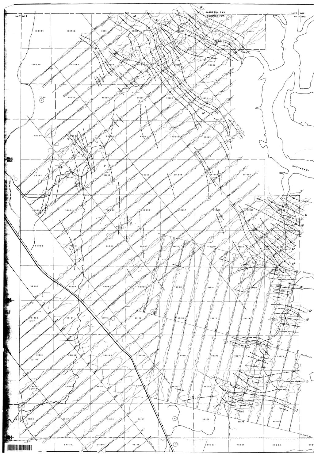
5 PRESENTATION OF DATA Plate l shows a profile presentation of the Turam results on a scale of l" - 0 feet. Along the profiles the field strength ratio (F.S.R.) is plotted at a scale of l" = 20^0 with the phase difference (A fi ) at a scale of l" :: 10 O. The positions of energizing loops is shown on plate 2. DISCUSSION OF RESULTS The more prominent conductive lineations have been and are marked on Plate l while the more interesting conductors have also been individually labeled. On the northern and eastern edges of the area, numerous well-defined, closely spaced current axes are evident. In the northern part of the area these axes run parallel to an ESE flowing tributary of the Mattagami river while along the eastern edge of the area the surface drainage system cuts perpendicular to the observed lineations. At both locations conduction within swamp and creek sediments is likely to have contributed to the anomalous current channeling, although the long nature of some of these features (eg., Aj, A2, Aj, A^, Cj and 02) would tend to indicate structural conductors, possibly graphitic in nature. Inter-line correlation is frequently hard to distinguish and it is sus pected that considerable variations in the conductivity and/or width of the conducting bands are present. The conductors may, in fact, "pinch-out" several times along their strike lengths. Furthermore, the complex nature of the data in the north is accentuated because certain sections were covered with a 100' cable and others with a 200' cable. Generally speaking, greater resolution can be expected with the shorter cable at the expense of lower amplitude anomalies over more deeply buried conductors. Many of the conducting systems are associated with reverse-sensed current axes (ie., a negative FSR in conjunction with a positive A{?) flanking the normal-sensed axis -- eg., Cj and C^. The well-defined reverse-sensed current axis between Aj and A.^ exhibits the most prominent electromagnetic distortion over the whole grid. Normally, anomalous expressions of this nature are attributable to a horizontal eddy current circulation which might be expected to be induced in a swamp or a wide conducting horizon, however, very complex basement structures can produce similar patterns. Conductors H, Jj and 13 all exhibit distortions of reverse sense and in the case of J j there is little evidence of a return flow. This may indicate that the anomalous source is dipping towards the loop, ie., to the east or northeast. The response from the same conductor with the loop on the foot-wall side, --ie., to the west -- might be expected to be considerably stronger. This vo uld tend to upgrade the possible significance of this zone.
6 *In the case of the multiple roughly parallel conducting axes, in groups A, B and C an estimation of a conductivity x width product is difficult to obtain because of the mutual induction from the various closely-spaced conductor axes. Qualitatively, however, "Q" values (ie., the ratio of in-phase to quadrature distortions) at almost all intersections indicate relatively poor to moderate conductivity x width. Except for conductors E and F, whose distortion patterns tend to exhibit a higher conductivity x width at certain intercepts, the remaining conductors also suggest conductivity x width products of poor to moderate magnitude. CONCLUSIONS AND RECOMMENDATIONS A Turam electromagnetic survey executed over a grid system in Godfrey Township, Kamis Kotia, Ontario, revealed the presence of numerous conduc tive lineations. Many of the observed distortions are probably related to lenses and/or banded horizons of graphite-rich material with overburden conduction having contributed to some extent. The existence of a massive sulphide source, however, cannot be excluded. Although, from the Turam data alone, a priority list cannot justifiably be made, some of the isolated conductors, eg., E, F, J, may prove to have more inter esting sources than the prominent distortions on the northern and eastern edges of the area. However, a careful checking of all known geological and geo chemical information in the vicinity of all of the more prominent conductor axes noted on Plate l is recommended. As it seems probable that many of the conductors found in the present survey have been previously located and tested, no drilling recommendations are being made at the present time. Scintrex Surveys Limited will be willing to discuss in greater detail areas in the immediate vicinity of the found conductors which are considered by Hollinger Mines to be of favourable geological interest. Respectfully submitted, P. R. Bailey, M.Se., D.I. C. Geophysicist Jan Geophysi
7 APPENDIX "T" BRIEF DESCRIPTION OF THE TURAM ELECTROMAGNETIC SYSTEM GENERAL The Turam method can be classified as a fixed source compensation method. The primary or source field consists of a large energizing layout in the form of a long wire or a large loop laid out on the terrain, to which an audio frequency alternating current is fed by means of a motor generator. The resulting current pattern is investigated inductively, with two identical receiving coils connected to a bridge compensator which compares the signal received in each coil in relative phase and amplitude. When grounded cable is used, the energization is both galvanic and inductive; when the primary layout consists of a closed loop, the energization is purely inductive. Under most conditions the presence of galvanic current is undesirable and inductive energization is, as a rule, preferred. Although the system allows the comparison of any two components of the resultant field, it is standard procedure in systematic surveys to measure the gradient of the vertical component. The pattern for a typical Turam survey is shown in Fig. 1. A large rectangular loop is used as primary layout and the field gradients are measured with horizontal receiving coils along profiles perpendicular to a long side of the transmitting loop. DATA REDUCTION The relative strength of the undisturbed primary field is dependent on the loop dimensions and the location of the observation points, and can be determined by calculation. The measured field strength ratios are normalized through division by these calculated free space ratios. The primary field causes eddy currents to flow in subsurface conductors. As a result the resultant field will be distorted in both amplitude and phase. The presence of conductors will thus be indicated by abnormal field strength ratios and phase differences.
8 PRESENTATION The measuring results are usually presented in profile form, as (reduced) field strength ration and phase difference curves, with the observed values plotted at the midpoint between coil positions. Occasionally one of the two parameters is presented in contour form, but contour plans are generally inadequate to express the full significance of the data. INTERPRETATION Where field distortion occurs the curves indicate the location and the depth of burial of the main current flow. The "current axis" is well defined when the current is concentrated as, for instance, in thin, steeply dipping conductors. In wide, banded conductors, or in horizontal conductors such as, for instance, overburden, the current is usually more dispersed and the anomalies will yield less positive information. As a rule the current axis is located right below the maximum field strength ratio deflection or the maximum negative phase shift. Its depth under the traverse is indicated by the shape of the anomaly. The relative amplitudes of field strength and phase distortions are a measure of the conductivity of the conducting bodies, i. e. good conductors are characterized by field strength distortion combined with relatively little phase shifting, whereas poor conductors affect the phase, rather than the strength of the resultant field. For an accurate grading the conductivity thickness tf t value the individual conductors can be derived from the calculated in-phase and out-of-phase components, taking further into consideration the exciting frequency and the strike length of the conductor. The relations are shown in Fi g. 2 and Fi g. 3. The obtained d t values are marked on the upper right side of the anomalies, in units of mho. On the lower left side the depth of the current axis (ft. ) is marked. It is normally located 30 - ft. within the body and the indicated depth should be regarded as the maximum depth to the upper surface of the conductor. To obtain the projection of the current pattern, the anomalies are connected between lines, whereby depth and (f t values, as well as other characteristics of the curves are used as criteria. The strike of the formations if known, is also taken into consideration. Fig. 4 and Fig. 5 show a plan and section of a typical Turam survey and interpretation. References: 1937 Hedstron, E. H Bosschart, R. A. Phase Measurements in Electrical Prospecting. AIME Techn. Publ. 827 Analytical Interpretation of Fixed Sourc Electromagnetic Prospecting Data. Delft.
9 - 3 - Fig, l The Turam method. General layout LENGTH - HEIGHT ' SCO m l. P/" * DEPTH '50m 2. P lv x DIP ' 60* 3. f/ff r Is to JO' K)' j rt X" 10 -~- Ohmcm lec/m 10" K)' FIG. 2 RESPONSE OF A FINITE TABULAR CONDUCTOR, (R.A. Bosschart 1964)
10 FIG. 3 RESPONSE DIAGRAM FOR CONDUCTORS OF VARYING STRIKE LENGTHS. FIG o 4 TURAM SURVEY ON THE MURRAY GROUP, NEW- BRUNSWICK. (R.A. Bosschart 1964) Jx N \ \ *P**OXIM4Tt OVTIINl of t vt. f mott tom ttiow tv*r*ct- '* f " V j "t *" -MM* S 5 '? J :
11 - 5 - f FR ri.to T (J K AM 660 t,, MURRAY DEPOSIT NCW-HtUNtWICK leo LINE 136 E 1. +IO COMPLCX COMfLCX ^ S ' V 1 t /J'-r x\ COHPONCNTS \ i' l \\ \^ t \ * -30. \*IW W too M* W 10 to MASS, suirmoet * c* r* j, M^SJ. tulphiocs CUHRCHT AXIS If (?* If* a FIG. 5 TURAM SURVEY ON THE MURRAY GROUP, NEW BRUNSWICK, INTERPRETATION OF A TYPICAL SECTION. (R.A. Bosschart 1964)
12 42AI1SW GODFREY 0S0 AUG PROJECTS UNIT MAGNETIC SURVEY on the GODFREY #2 & # 4 GROUPS Hollinger Mines Limited Godfrey Township, Ontario H. Z. Tittley, P. Eng. Timmins, Ontario July 30, 1974
13 Godfrey Twp. MMBBV ^m ^mmmm Mountjoy Twp. H- L 0--
14 INTRODUCTION A magnetic survey was carried out by Hollinger Mines Limited on its Godfrey #4 Group in Godfrey Township near Tim mins, Ontario during March and April 19,7.0- The purpose of the survey was to assist in outlining the underlying geological features. Several north trending anomalies, attributed to diabase dykes, have been outlined. The accompanying map shows the results obtained over the area surveyed. PROPERTY. LOCATION AND ACCESS The portion of Godfrey #4 Group covered by the mag netic survey consists of 54 contiguous mining claims situated in lots 2 to 6 in the fourth, fifth and sixth concessions in Godfrey Township, Porcupine Mining Division. The claims are: P to P inclusive P to P " P to P " P to P " P to P " P to P " P to P " The property lies entirely between the Mattagami River to the east and Highway #576 that crosses Godfrey Town ship immediately west of the claims. Both of these provide access to the property from Timmins, situated six miles to the east. HISTORY Although Godfrey Township has been the scene of a considerable amount of exploration activity over the past years, most of the claims that fall within the scope of this report have received little or no attention. Mespi Mines Ltd. put down three diamond drill holes in 1964 following the com pletion of a geophysical program on the most northwesterly claims. Three holes put down on claim # P at the end
15 - 2 - of a long bay of the Mattagami River are believed to have been drilled in the 19's by a group named McKay-Colgan while sear ching for gold. GEOLOGY The entire area of the property is underlain by keewatin lavas of felsic and basic composition cut by younger north trending quartz diabase dykes. Rhyolites exposed in a prominent ridge that extends from the middle of Godfrey Twp. to the centre of Jamieson Twp. are visible in outcrop on claims P and P in the northwest corner. Basic lavas are visible near the Mattagami River along the east boundary, but these are believed to occur east of a major displacement fault (Mattagami River fault), and would there fore not be part of the same volcanic sequence. Surficially, the.property is situated along the southern edge of the clay belt (Barlow-0jibway formation). This flat, heavily wooded plain consists mainly of clays, some sand and occasional boulders. Overburden thicknesses vary from the bedrock surface in the west to hundreds of feet under the Mattagami River where the latter and its tri butaries have gouged down nearly 100 feet into the alluvium. SURVEY METHOD On the two existing grids of lines shown on the accompanying plan, readings were taken 100'feet apjj,rt or less with two A.B.E.M. Mz-4 torsion wire magnetometers cap- " '"" '! ' ' ' "' "' " " J'' J"*'*- i " 1 '''-'1* ' ""- '-'r": 'J1" --'.L' '.,. i.: T.'Wot-*.:?".:'' rirs" I.'S 4y l~'"yt' 1 r'^'i^^vi.^ 1'':' *.:- -l, -f..'jpiy 1!* "*.j L -;!'j t- H ^r^iuyt;rtkmi(tisot 111'ail'i,J'!i1l'iivji'SVriiBiSSBH 1 '- able of measuring the vertical component of the earth's magnetic field. Base stations were established along the base lines at the even 0 foot intersections by averaging two repeat loops encompassing each of the points. Main base stations, located throughout the property, were related through
16 - 3 - observations to the government magnetic base on the Bristol- Ogden Township boundary where an arbitrary value of 945 gammas has been assigned. Diurnal and instrument drift vari- "tafc'srl 'X.,*3ip'. IBy5M 1 -- ations were recorded by repeating the bases and were subtract ed from the readings. The arbitrary value of 945 was then added to complete the corrections in gammas. RESULTS The results of the survey are presented as iso magnetic contours on the accompanying plan entitled "Geo magnetic Survey" at a scale of l inch to 0 feet. All of the north and northwest trending magnetic features are interpreted as diabase dykes. A northeasterly trending magnetic anomaly on claims P is believed to be due to concentrations of magnetite within basic lava flows. The presence of the Mattagami River fault which is generally projected near the east boudary of the group is not readily discernable from the data. However, the north trending contours on claim P-99234, to the north, near the north part of claim P and through the centre of claim P along the south boudary may represent part of the fault. CONCLUSIONS The amount of.".information revealed by the magnetic survey is interminable and will prove of great merit when evaluating other geophysical surveys. Respectfully submitted/4" H. Z. Tittley, P.
17 GEOPHYSICAL - GEOLOG J TECHNICAL DATA ' ' sw035 2 ' 550 GODFREY TO BE ATTACHED AS AN APPENDIX TO TECHNICAL REPORT FACTS SHOWN HERE NEED NOT BE REPEATED IN REPORT TECHNICAL REPORT MUST CONTAIN INTERPRETATION, CONCLUSIONS ETC. Type of Geophysical Turam Electromagnetic Township or Area Godfrey Tvp. Claim hn]rw. Hollinger Mines Limited Box 320, TIMMINS, Ontario Author of eport Klein, M8c. t P.Eng. Address Scintrex Surveys - Limited, y. a ^ ^ Concord, Ontorlc Covering Dates of March 15 to June 1974 Total Miles of Line cut (linccutting to office) 900 AU PROJECTS UNIT MINING CLAIMS TRAVERSED List numerically (prefix) (number) See Attached Sheet SPECIAL PROVISIONS CREDITS REQUESTED ENTER 'days {includes line cutting) for first survey. ENTER 20 days for each additional survey using same grid. Geophysical -Magnetometer. -Radiometric -Other Geological. Geochemical. DAYS per claim 20 AIRBORNE CREDITS (Special provision credits do not apply to airborne surveys) Magnetometer..Electromagnetic.. Radiometric (enter days per claim) DATE:. SIGNATURE:. Author of Report or Agent PROJECTS SECTION Res. Geol. ^. Previous Surveys D*' fl' O Qualifications l l iw l E t* O Checked by..date. GEOLOGICAL BRANCH. Approved by..date. GEOLOGICAL BRANCH. Approved by. -date. TOTAL CLAIMS. M-5
18 Show instrument technical data in each space for type of survey submitted or indicate "not applicable" GEOPHYSICAL TECHNICAL DATA GROUND SURVEYS Number of Stations ±73(1 Number of Readings Station interval 100 feet ' Line spacing Q Profile scale or Contour intervals I"a20ff vith phase (specify for each type of survey) MAGNETIC Instrument -^ ^^ ^^ ^^^ ^ Accuracy - Scale constant Diurnal correction method Base station location ELECTROMAGNETIC instrument SE 71 Scintrex Tureip three frequency Electromagnetic Unit Coil^figuration Loop ranged from 2000 x 2000 ft. to 00 * 3200 ft. - Coil separation 200 ft* Accuracy^^ -.^^^^ ^^^^^^^^^^.^^^^-^-^- ^- ^.^.^-^^-^^^^^^^^..^- ^-^.^^^^^-^^-^^.^ Method: O Fixed transmitter CD Shoot back CD Inline CD Parallel line Frequency 0 H-2 Energising Slgnel (specify V.L.F. station) Parameters m P^..r^ Field Strength Ratio ft Phase Difference Curves - GRAVITY Instrument ^ ^^^ ^ Scale constant. Corrections made. Base station value and location. Elevation accuracy ^ -.. INDUCED POLARIZATION - RESISTIVITY Instrument-^. ^ ,-, Time domain Frequency domain. Frequency Range^ -^^ Power^. ^^.^ - ^^^ ^^. -.. Electrode array Electrode spacing. Type of electrode.
19 St, of * Qfttpitfiittl tom B to ID so fftff to 9ftff St t*ni so t*sto to 9fsu so UMI to to tt*s ao SO 9fS6f St SO WM SO WIO SO 9fS6f SO WSt SO Wftf M WS9 SO W70 SO WSI SO W7I SO wt? so wn so W** SO WTI St ^^^k^^ajk rik^k j^^^^^^i ^^^ 99*S9 SO WT6 St WIO SO W77 SO wn so nnu st SO Simt S175IO HOLLIiia'R :.;..;^ Lii'/.i.TIMMINS, ONTARIO
20 File. Type of Survey Township or Area. Claim holder(s) GEOPHYSICAL - GEOLOGICAL - GEOCHEMICAL TECHNICAL DATA STATEMENT TO BE ATTACHED AS AN APPENDIX TO TECHNICAL REPORT FACTS SHOWN HERE NEED NOT BE REPEATED IN REPORT TECHNICAL REPORT MUST CONTAIN INTERPRETATION, CONCLUSIONS ETC. Geophysical Turam Electromagnetic Godfrey Twp. Hollinger Mines Limited Box 320, TIMMINS, Ontario Author of Report Jan Klein. Msc. t P.Eng*, Scintrex Surveys Limited, concord, Ontari Address- Covering Dates of S,urvey. Total Miles of Line cut Jan. l to June 23, 1974 To office) 78*13 t AUG PROJECTS UNIT MINING CLAIMS TRAVERSED List numerically (prefix) P- (number) SPECIAL PROVISIONS CREDITS REQUESTED ENTER days (includes line cutting) for first survey. ENTER 20 days for each additional survey using same grid. ~,., Geophysical T Ur ton.^electromagnetic Magnetometer. Radiometric Other Geological. Geochemical. DAYS per claim AIRBORNE CREDITS (Special provision credits do not apply to airborne surveys) Magnetometer..Electromagnetic,. Radiometric (enter days per claim) 4Q *. t *C.T. W^'tf f A * * l DATE:. SIGNATURE:. Author of Report or Agent PROJECTS SECTION Res. Geol.,.. Qualifications Previous Surveys g ws Checked by..date. GEOLOGICAL BRANCH. fa b O Approved by..date. GEOLOGICAL BRANCH. Approved by. -date. TOTAL CLAIMS 12
21 Show instrument technical data in each space for type of survey submitted or indicate "not applicable" GEOPHYSICAL TECHNICAL DATA GROUND SURVEYS Number of Stations Station interval. Line spacing Profile scale or Contour intervals. MAGNETIC 616.Number of Readings. 100 ft. AOO ft. vith phase difference (specify for each type of survey) 616 Instrument Accuracy - Se Diurnal correction method ^! Base station location ELECTROMAGNETIC instrument Sciiitrex SE 71 three frequency Turam Elftctromagnfltlc Coil configuration. Loop from 2000 x 2000 feet to 4800 x 3200 Coil separation Arnirary Method: Frequency 200 ft* d Fixed transmitter C] Shoot back d Inline O Parallel line {specify V.L.F. station) Parameters measured Field Strength Ratio ie Phase difference Curves GRAVITY Instrument. Scale constant. Corrections made. Base station value and location. Elevation accuracy ^^^ ^ INDUCED POLARIZATION - RESISTIVITY Instrument,^ - - ^. - ^ Time domain. Frequency Power. Electrode array Electrode spacing. Type of electrode. Frequency domain.. Range.... ^
22 OIHYINO 'SN mm PT:: r' r :-.nffl tjtwf 01 ot oi tin* firaf CltW tlftfc TltttC oirwc JttlfC
23 File. GEOPHYSICAL - GEOLOGICAL - GEOCHEMICAL TECHNICAL DATA STATEMENT Type of Survey Township or Area. Claim holder(s) TO BE ATTACHED AS AN APPENDIX TO TECHNICAL REPORT FACTS SHOWN HERE NEED NOT BE REPEATED IN REPORT TECHNICAL REPORT MUST CONTAIN INTERPRETATION, CONCLUSIONS ETC. Geophysical Magnetic Godfrey Twp. Hollinger Mines Limited Box 320, TIMMINS, Ontario. Author of Report H* Z * Tittlty Box 320, TIMMINS, Ontario Covering Dates of Survey NoT * ^68 to Attg. 26, 19?4 (linccutting to office) Total Miles of Line mt 5*6*7 ^ MINING CLAIMS TRAVERSED List numerically (prefix) (number) SPECIAL PROVISIONS CREDITS REQUESTED ENTER days (includes line cutting) for first survey. ENTER 20 days for each additional survey using same grid. Geophysical Electromagnetic. Magnetometer_i Radiometric Other Geological. Geochemical. DAYS per claim a s AIRBORNE CREDITS (Special provision credits do not apply to airborne surveys) Magnetometer..Electromagnetic.. Radiometric (enter days per claim) DATE:. SIGNATURE:. Author of Report or Agent PROJECTS SECTION Res. Geol. Qualifications Previous Surveys i u s Checked by..date. GEOLOGICAL BRANCH. fa o Approved by. -date. GEOLOGICAL BRANCH. Approved by. -date. TOTAL, CLAIMS.
24 Show instrument technical data in each space for type of survey submitted or indicate "not applicable" GEOPHYSICAL TECHNICAL DATA GROUND SURVEYS Number of Si a t inn s 2976 Number of Readings Station interval 100 feet Line spacing 0 feet fc 200* in the South End Profile scale or Contour intervals {specify for each type of survey) MAGNETIC Instrument A.B.E.M. MZ^ Serial Mot g. /,539 ynlff ^599 Accuracy - Scale n,tant 10-l and 9*9 gammas per scale division Diurnal correction method RetUTO LOOPS Government 6 B se Base station location Qn Bristol-Ogden Twp. Boundary ELECTROMAGNETIC Instrument. ^^-^^^^ ^ -. Coil configuration. Coil separation Accuracy Method: O Fixed transmitter O Shoot back d Inline CD Parallel line Frequency^^^ ^-^ ^^^^^^..^^^^^^^^^^^^^^^. ^^^^..^^^^^.^^^^^^^ ^ ^^^^. ^^^^^^. (specify V.L.F. station) Parameters measured - -^^ ^^^^^^ ^ --^.^-^^^^^^^^ ^^ ^^^^^ -^.^ ^-. GRAVITY Instrument. Scale constant. Corrections made. Base station value and location. Elevation accuracy.....^^.^^ INDUCED POLARIZATION - RESISTIVITY Instrument...^ ^...- Time domain Frequency domain. Frequency Range ^ - Power.^ ^- ^^- -^ Electrode array Electrode spacing, Type of electrode.
25 f * W ^^4^*^m^* 99* ^kj^j^dh^ ^h^h^k^^^ft * WI7 992M
26 TRIM LINE * T-- d CO j Jamieson Twp. (M.288) Gap Radar Sto Dept.ol Nolionol Defencs IWirhdrown from Stoking Mining Act. P. - Ml. J 5K.ULKjm - Jamieson, '/L 1366 ;B4976 f i i i i SMNO ' 009SI THE TOWNSHIP OF GODFREY 01 (X) 4- DISTRICT OF COCHRANE PORCUPINE MINING DIVISION ' K SCALE: 1-INCH 4O CHAINS LEGEND -0 ^ H -C UJ M Q O CD CD IO Q. 5.Q Cu. 3 K ( P fpvp. P AP H P V 13J94I l j Y /I96445 p-7--^ -p-" 96139! P. i P 38Z P I7I' l CM O to c 3 o PATENTED LAND CROWN LAND SALE LEASES LOCATED LAND LICENSE OF OCCUPATION MINING RIGHTS ONLY SURFACE RIGHTS ONLY ROADS IMPROVED ROADS KING'S HIGHWAYS RAILWAYS POWER LINES MARSH OR MUSKEG MINES CANCELLED PATENTED S.R.O. NOTES 0' surface rights reservation along the shores of all lakes and rivers. c. e Flooding rights on either s ide of the Mattagami to H.E.RC. o rr rj; m l- B? cr.3822 ^ This township lies within the Municipality of C ITY o f TIMMINS \! MINING ^nwi DATE OF ISSUE OOT^81974 AWNISTRV gf NATURAL ftkqhq^ 17 X) O 12 Bristol Twp. (M.264) PLAN NO. M ONTARIO MINISTRY OF NATURAL RESOURCES SURVEYS AND MAPPING BRANCH t? OD LO 42A11SW GODFREY TRIM LINE
27
28 42A11SWia35ia GODFREY

29 QP.N-5.. x. Ay v l l * - 5 '**i, r**\ J f /v r ;
30 JAMIESON TWR GODFREY TWP. /CONDUCTOR AXIS HOLLINGER MINES LIMITED I20r0epth of conductor in feet GODFREY TWR KAMIS KOTIA, ONTARIO Hz o^ 100 feet TURAM ELECTROMAGNETIC SURVEY SURVEY BY SCINTREX SE-71 EM SCINTREX SURVEYS LTD MAR.JUNE 1974 SCALE l =0
31 .V* JAMIESQR TWR r* HOLLINGER MINES LIMITED GODFREY TWP. GODFREY TWR KAMIS KOTIA, ONTARIO ENERGIZATION LOOP LOCATION PLAN SCALE l" = 4OO' SURVEY BY SCINTREX SURVEYS LTD. MAR.JUNE 1974 PLATE 2
32 JAMIESON T WP GODFREY TWP. HO L L NGER Ml N ES LT D. Godfrey Group No. 4 GODFREY TWP. ONT. GEOMAGNETIC SURVEY SCALE- i INCH TC 4oc r F F NORTH - EAST SHEET LOCATION MAP Scale : l" s 4 mi Property Boundary *'* ' l J l i / '*V 'J \V\\' CONTOUR INTERVALS In gammas
Toronto, Ontario November 16, This report may not be reproduced, in whole or in part, without the written permission of Derry, Michener S Booth.
 13 2.1354 L ITTLE 010 GEOPHYSICAL SURVEYS, LITTLE TOWNSHIP CLAIM GROUP OB-F TIMMINS AREA PORCUPINE MINING DIVISION, ONTARIO Toronto, Ontario November 16, 1973 This report may not be reproduced, in whole
SUPPLEMENT TO MAGNETOMETER 6 ELECTROMAGNETIC SURVEY REPORT. DATED NOVEMBER l, 1973 CIGLEN INVESTMENTS LIMITED CLAIMS GROUP BAD VERMILLION LAKE AREA
 ^ A R l ^ 1974 010 PROJECTS UNIT SUPPLEMENT TO MAGNETOMETER 6 ELECTROMAGNETIC SURVEY REPORT DATED NOVEMBER l, 1973 CIGLEN INVESTMENTS LIMITED CLAIMS GROUP BAD VERMILLION LAKE AREA DISTRICT OF RAINY RIVER
Assessment Report by the Canadian Nickel Co. Ltd. Magnetometer Survey. Larder Lake Mining Division Lebel Tovnship, Ontario
 32084Nwea67 2.331* LEBEL 010 Assessment Report by the Canadian Nickel Co. Ltd. Magnetometer Survey Larder Lake Mining Division Lebel Tovnship, Ontario Claims L-531657 L-531658 L-531111 Map No.: M-359,
Introducti on. Land Survey. Geomagnetic Survey. Geomagnetic Results and Interpretati ons - Conclusions and Recommendations C
 m M 42A86SW8281 63.42 PRICE 010 C O H T E H l 42A86SW828I 63.42 PRICE 010C Introducti on Land Survey Geomagnetic Survey Geomagnetic Results and Interpretati ons - Conclusions and Recommendations - - -
REPORT ON Y ~L/~E A TURAM ELECTROMAGNETIC SURVE'Y HOUSTON AREA, BRITISH COLUMBIA ON BEHALF OF PERRY, KNOX AND KAUFMAN, INC
 REPORT ON Y ~L/~E A TURAM ELECTROMAGNETC SURVE'Y HOUSTON AREA, BRTSH COLUMBA ON BEHALF OF PERRY, KNOX AND KAUFMAN, NC TABLE OF CONTENTS Page No., NTRODUCTON DESCRPTON OF METHOD AND NSTRUMENTATON GEOLOGY
Geomagnetic. Guibord Township Group #2, Bast Part Hollineer Consolidated Gold Mints. Ltd
 42Aa9SEe267 63.19,9 GUIBORD """"" 11 Geomagnetic Guibord Township Group #2, Bast Part Hollineer Consolidated Gold Mints. Ltd 010 Introduction During the period March 31 t 1965 to Jan. 10, 1966 a magnetometer
r ffj Ronald C. Wells, BSc. Lacana Mining Corporation LACANA CLAIMS GAUTMER TOWNSMP GEOPHYSICAL REPORT OCT LARDER LAKE MINING DIVISION
 a- 32D04NWei39 2.3507 GAUTHIER 010 GEOPHYSICAL REPORT LACANA CLAIMS GAUTMER TOWNSMP LARDER LAKE MINING DIVISION RECEIVED OCT171980 MINING UNDS SECTION Author: Ronald C. Wells, BSc. Lacana Mining Corporation
Hollinger Mines Limited Godfrey Township, Ontario
 42A12SE8419 2.1398 GODFREY 010 SECTION GEOPHYSICAL SURVEYS Ot T THE GODFREY #4 GROUP Hollinger Mines Limited Godfrey Township, Ontario January 21, 1974. H.Z. Tittley, P.Eng. SUMMARY Over the past four
t y RECEIVED This report is concerned with the results of the electromagnetic survey as applied to the following claims: l K to K
 t y 53F*4NWei37 2.1853 HERONRY LAKE 010 HUDSON BAY EXPLORATION AND DEVELOPMENT COMPANY LIMITED ELECTROMAGNETIC SURVEY OF GROUP "N" EAGLE PROJECT - KAKAGI BLOCK KENORA MINING DIVISION - ONTARIO RECEIVED
Newmont Exploration of Canada Limited Box 105 Commerce Court West, Toronto, Ontario MSL 1E3
 41PI5NE8341 3.3338 CAIRO 010 GEOPHYSICAL SURVEY REPORT MAGNETOMETER SURVEY CAIRO PROJECT CAIRO TOWNSHIP - NTS: 41 P/15 by Newmont Exploration of Canada Limited Box 105 Commerce Court West, Toronto, Ontario
magnetic and electromagnetic survey carried out to locate on the ground an aeromagnetic zone and associated In-put anomalies indi
 42IICWMW 63.2293 FLINCH LAKE O1O 6 3- Z* The President and Directors, Consolidated Manitoba Mines Limited. 114 East 90th Street. New York City 10028. New York. U. S. A. Gentlemen: This report describes
RECEIVED. .* : - Al IR l MINING LANDS SECTION. Deborah McCombe Abltlbi-Price Inc. Mineral Resources Division July 28, 1981
 010 RECEIVED.* : - Al IR l 21981 MINING LANDS SECTIN REPRT N MAX-MIN II AND MAGNETIC SURVEY by ABITIBI-PRICE INC. MINERAL RESURCES DIVISIN LUCAS TWP. NTARI CLAIMS Deborah McCombe Abltlbi-Price Inc. Mineral
SELCO EXPLORATION COMPANY LIMITED
 --..-..-...-.....l.iibibiiiiiiiiiiiiiii II III S2J16NW9001 52J16NW0014A1 PASHKOKOGAM LAKE 0 10 SELCO EXPLORATION COMPANY LIMITED GEOPHYSICAL REPORT CLAIMS 200696 TO 200707 PATRICIA MINING DIVISION August
Report on The Magnetic Survey. Property of Loydex Resources Inc. Keigat Lake Area. Red Lake Mining Division
 010 Report on The Magnetic Survey On The Property of Loydex Resources Inc. SANDY POINT PROJECT Keigat Lake Area District of Kenora, Patricia Portion Red Lake Mining Division N.T.S. 52-N-8 Whitby, Ontario
OEOMAQNETIC SURVEI QUIBORD TOWNSHIP GROUP #2 HOLLINGER CONSOLIDATED GOLD MINES, LTD.
 OEOMAQNETIC SURVEI QUIBORD TOWNSHIP GROUP #2 HOLLINGER CONSOLIDATED GOLD MINES, LTD. 42Ae9SE0268 63.1502 GUIBORD (711(71 Introduction During the period January 5 - February 26, 1965, a magnetometer survey
REPORT OF THE MAGNETOMETER SURVEY. GROUP l, GRID A - BEE LAKE AREA CLAIM MAP M2194, RICKABY LAKE KENORA MINING DIVISION, ONTARIO
 S2L1&NW0813 3.1334 EAGLE LAKE 010 3 K EC El V ED REPORT OF THE MAGNETOMETER SURVEY GROUP l, GRID A - BEE LAKE AREA CLAIM MAP M2194, RICKABY LAKE KENORA MINING DIVISION, ONTARIO by SELCO MINING CORPORATION
33) Z SKEAD
 Z SKEAD") 33)04860396 Z. 1700 SKEAD 010 i j R. A. MACGREGOR, P.ENG. PAGE NO. l In t r odu c t ion Report on Magnetometer and VLF-EM Survey Part of Lots l to 6, Concessions 5 and 6 f Skead Township, Ontario - Linecutting,
33)04860396 Z. 1700 SKEAD 010 i j R. A. MACGREGOR, P.ENG. PAGE NO. l In t r odu c t ion Report on Magnetometer and VLF-EM Survey Part of Lots l to 6, Concessions 5 and 6 f Skead Township, Ontario - Linecutting,
NICOLA M.D King Street West, April, 1969 AMALG 1-44 MINERAL CLAIMS 1. OWNER: Dr. F. R. Burton, W. M. Sirola, P. Eng.
 REPORT ON ' MAGNETIC AND ELECTROMAGNETIC SURVEY AMALG 1-44 MINERAL CLAIMS 1. NICOLA M.D. 49'501 N - 12Oo57f W OWNER: Dr. F. R. Burton, 1506-44 King Street West, Toronto 1, Ontario. by W. M. Sirola, P.
42H88SW NEWMAN
 42H88SW0003 63.8199 NEWMAN 010 TRIPOINT MINES LIMITED, Suite 305-100 Adelaide St. West, Toronto l, Ontario. Gentlemen: Your Company recently conducted a combined magneticelectromagnetic survey over a ten
Report of Gridding and Magnetic Surveys. On the. Munro Property. Munro and Beatty Townships, Ontario. Larder Lake Mining Division
 Report of Gridding and Magnetic Surveys On the Munro Property Munro and Beatty Townships, Ontario Larder Lake Mining Division Claims: 39 4244 For Big Red Diamond Corporation October 3, 2 Timmins, Ontario
ZENMAC METAi, MINES LIMITED. SCHHKIBEK, ONTnHlO. PURVEY OK THE NI'COPOR PROPERTY
 63.2625 PAYS PLAT LAKE 010 ZENMAC METAi, MINES LIMITED SCHHKIBEK, ONTnHlO. PURVEY OK THE NI'COPOR PROPERTY IS'iRODUCTIQM The property, about 6 miles north of Schreiber, has been held by various people
RECEIVED JUL28. AM t: /5 n OM MINING LANDS SECTION. MINING ojy: MAY, 1988 GEOPHYSICAL REPORT VLF-EM SURVEY OBRADOVICH CLAIMS
 2.11443 GUIBORD 010 GEOPHYSICAL REPORT VLF-EM SURVEY OBRADOVICH CLAIMS GUIBORD TOWNSHIP LARDER LAKE MINING DIVISION DISTRICT OF COCHRANE, ONTARIO RECEIVED JUL28 MINING LANDS SECTION MINING ojy: fju,l 2
Gold Mountain Group Gold Mtn. A, B, C & D Mineral Claims Record Nos. 697, 698, 699 & 700. Island Mountain Cariboo Mining Division British Columbia
 GOLD POINT RESOURCES LTD. Geophysical Survey Gold Mountain Group Gold Mtn. A, B, C & D Mineral Claims Record Nos. 697, 698, 699 & 700 Island Mountain Cariboo Mining Division British Columbia Vancouver,
AND HORSEFLY PROSPECTS, N.W. BRITISH COLUMBIA NTS, 103H/ll, 14 FOR ATNA RESOURCES LTD DELTA GEOSCIENCE LTD
 AND HORSEFLY PROSPECTS, N.W. BRITISH COLUMBIA NTS, 103H/ll, 14 FOR ATNA RESOURCES LTD BY DELTA GEOSCIENCE LTD FE T A. HENDRICKSON, P.GEO. 1 . TABLE OF CONTENTS Introduction............. Page 1. Personnel..........
SANDER GEOPHYSICS LW 42D13SW ISLE ST. IGNACE RICHMONl
 SANDER GEOPHYSICS LW 42D13SW8363 83.1-117 ISLE ST. IGNACE 010 1305 RICHMONl REPORT ON THE HELICOPTER BORNE EM AND MAGNETOMETER SURVEY OFF ST. IGNACE ISLAND, LAKE SUPERIOR THUNDERBAY MINING DISTRICT, ONTARIO
WAONEK-MILLS JPHVSiCAL SURVEYS
 xxxxxx L. i* ^- O PHONE HO, C - 7526 XXXXXXX) WAONEK-MILLS JPHVSiCAL SURVEYS XXXXXAAA SUITE 401, 62 RICHMOND ST. WEST 15 MEREDITH. IEREDITH. C RESCENT TOR.ONTO. TORONTO, CANADA till6ne0082 0815C1 SCHOLES
REPORT ON GEOPHYSICAL SURVEYS ON THE BAMAJI LAKE PROPERTY CROBIE PROJECT, NW ONTARIO OF UMEX INC.
 S20e3NWe«28 S20«3NWee37 FRY LAKE 0 1 0 REPORT ON GEOPHYSICAL SURVEYS ON THE BAMAJI LAKE PROPERTY CROBIE PROJECT, NW ONTARIO OF UMEX INC. Patricia Mining Division NTS 52 0/3 Latitude 51 10'N Longitude 91
Total Magnetic Field and VLF Surveys on the Swayze Property. Claim Swayze Township. Porcupine Mining Division
 1 January, 016 NTS: 041 O 15 Total Magnetic Field and VLF Surveys on the Swayze Property Claim 475471 Swayze Township Porcupine Mining Division 380850E, 599450N UTM Z17N NAD83 Report Prepared for: 540
.April 3, Jon G. Baird, B.Sc., P.Eng. LOCATION : One mile west of Mile 70 on the Haynes Road At lin Mining Division 135" 59 O SE
 , It I i REPORT ON MAGNETIC AND ELECTROMAGNETIC SURVEYS ON SOME LUNAR CLAIMS NADAHINI MOUNTAIN AREA NORTHERN BRITISH COLUMBIA ON BEHALF OF MAX FUERSTNER AND IRWIN DEFT 1 t Jon G. Baird, B.Sc., P.Eng..April
Magnetic Field and VLF Surveys on the Shining Tree Property. Claims: , , , , , , , ,
 December 29, 2014 NTS: 041P11 Magnetic Field and VLF Surveys on the Shining Tree Property Claims: 1203361, 4251801, 4251803, 4251805, 4263067, 4263068, 4270940, 4270436, 4276740 Churchill and Asquith Townships
Fox 2-Record No. 2524
 F HELICOPTER E.M. AND MAGNETOMETER SURVEY OVER THE FOX CLAIMS, OMINECA MINING DISTRICT BRITISH COLUMBIA ON BEHALF OF OWNER MR. MIKE BOYLE Claims: Fox l-record No. 2523 Fox 2-Record No. 2524 Location 126'
Project # Toronto, Canada. J. L. Wright June, 1978 WAGKICH LAKE PROPERTY REPORT ON GEOPHYSICAL SURVEYS SUMMER 1977
 31Me4SWa039 2.2725 S TRATHCONA 010 WAGKICH LAKE PROPERTY REPORT ON GEOPHYSICAL SURVEYS SUMMER 1977 Project #133.1 Toronto, Canada J. L. Wright June, 1978 INTRODUCTION A magnetometer and horizontal loop
THE ALGOMA STEEL CORPORATION, LIMITED GEOPHYSICAL REPORT GEONICS V.L.F. E.M.-16 ANOMALY #15 - CHABANEL TOWNSHIP SAULT STE. MARIE MINING DIVISION
 42CC2SE8880 ee^sat CHABANEL 010 THE ALGOMA STEEL CORPORATION, LIMITED RECEIVED SEP-41981 MINING LANDS SECTION GEOPHYSICAL REPORT GEONICS V.L.F. E.M.-16 ANOMALY #15 - CHABANEL TOWNSHIP SAULT STE. MARIE
December 6th I960. President and Directors, Chipman Lake Mines Ltd. 25 King Street West, Toronto.
 OFFICE: EM, 3-3933 RES.: HU. 1-1265 "' Mfc 42A85NE0127 63.1089 GODFREY 010. D. President and Directors, Chipman Lake Mines Ltd. 25 King Street West, Toronto. December 6th I960 REPORT ON GEOPHYSICAL SURVEY
We are committed to providing accessible customer service. If you need accessible formats or communications supports, please contact us.
 We are committed to providing accessible customer service. If you need accessible formats or communications supports, please contact us. Nous tenons à améliorer l accessibilité des services à la clientèle.
41016SE0035 Z GENOA 010
 41016SE0035 Z. 1058 GENOA 010 3.106? GEOLOGICAL SURVEY GENOA TOWNSHIP PROPERTY RUSH LAKE EXPLORATIONS LIMITED SUMMARY The following report describes the results of a geological ^survey conducted over the
3'^760. /{//o RED LAKE MINING DIVISION o O 2f fa//...
 010 3'^760 fr^. GEOLOGICAL ASSESSMENT REPORT lvl g f ; ; a ^, r PAW CREEK 1-76 ^ fc ^'^ /{//o RED LAKE MINING DIVISION o O 2f fa//... NTS 53C-13, D-16 INTRODUCTION A detailed geological survey at a scale
Nickel Division - Sudbury Operations
 * *-.. FALCONBRIDGE NICKEL MINES LIMITED Nickel Division - Sudbury Operations Falconbridge, Ontario 002261 GRAHAM 010 GEOLOGY OF TllE NORTH QUARTER OP LOT 2, CON. IV, GRAHAM TOWNSHIP, DISTRICT OP SUDBURY,
The two blocks of claims covered by the program of geophysi cal survey are listed as follows:
 \ 63-/S73 The President and Director*, Globe Exploration fe Wining Co. Ltd., Suite 4 -)3, 62 Richmond Street West, Toronto, l, Ontario, 42A11SE8087 63.1573 HOYLE 010 Gentlemen: This report describes the
Norlex Mines Property. Whitefish Bay Area, Kenora District. The property of Norlex Mines under option to Canadian Javelin
 52E09SW0025 63.2231 WHITEFISH BAY AND MA Norlex Mines Property D: KENORA 010 D. SEP 14-1967 RECEIPT No. MINING DIVISION Whitefish Bay Area, Kenora District. '; Introduction The property of Norlex Mines
We are committed to providing accessible customer service. If you need accessible formats or communications supports, please contact us.
 We are committed to providing accessible customer service. If you need accessible formats or communications supports, please contact us. Nous tenons à améliorer l accessibilité des services à la clientèle.
r.- L A c, i*-...-' &V set T.ANTHONY GROUP k COUTURE LAKE GROUP* STURGEON LAKE AREA ONTARIO COPCONDA-YORK RESOURCES INC. GEOPHYSICAL SURVEYS ON THE
 52J02SE8687 63.4234 SQUAW LAKE 010 r.- b; i*-...-' &V COPCONDA-YORK RESOURCES INC. GEOPHYSICAL SURVEYS ON THE T.ANTHONY GROUP k COUTURE LAKE GROUP* STURGEON LAKE AREA ONTARIO December 30, 1983. L A c,
MAGNETIC SURVEY REPORT. on the O'BRIEN CLAIM GROUP. Deloro Township Porcupine Mining Division, Ontario. for PAMOUR PORCUPINE MINES LIMITED
 42A06NE0456 2.7439 DELORO 010 MAGNETIC SURVEY REPORT on the O'BRIEN CLAIM GROUP Deloro Township Porcupine Mining Division, Ontario as se C/J 1* m O for PAMOUR PORCUPINE MINES LIMITED by Kian A. Jensen,
42A88SE9en 2.36H2 BENOIT 010 MINING IMW* **-' r REPORT ON GEOPHYSICAL SURVEYS ON PROPERTY OF GOLIATH MINES LTD. BENOIT TOVINSHIP, ONTARIO L J
 42A88SE9en 2.36H2 BENOIT 010 MINING IMW* **-' r REPORT ON GEOPHYSICAL SURVEYS ON PROPERTY OF GOLIATH MINES LTD. BENOIT TOVINSHIP, ONTARIO ~l L J PROSPECTING GEOPHYSICS LTD. REPORT GEOPHYSICAL SURVEYS ON
ASSESSMENT REPORT N 0. REPORT ON HORIZONTAL COPLANAR LOOP ELECTROMAGNETIC SURVEY HOUSTON AREA OF BRITISH COLUMBIA AQUITAINE COMPANY OF CANADA DURING
 tf 62 33 REPORT ON HORIZONTAL COPLANAR LOOP ELECTROMAGNETIC SURVEY IN THE HOUSTON AREA OF BRITISH COLUMBIA BY AQUITAINE COMPANY OF CANADA c DURING MARCH 21 - MARCH 25, 1977 MINERAL RESOURCES BRANCH ASSESSMENT
48AI1SEOM MURPHY ABEM MZ. 4 GEOMAGNETIC SURVEY ROTA LAKE GROUP MURPHY TOWNSHIP. Hollinger Mines limited April 23, 1971.
 48AI1SEOM7 2.377 MURPHY 010 ABEM MZ. 4 GEOMAGNETIC SURVEY ROTA LAKE GROUP MURPHY TOWNSHIP Hollinger Mines limited April 23, 1971. GEOMAGNETIC SURVEY ROTA LAKE GROUP MURPHY TOWNSHIP Introduction; On March
We are committed to providing accessible customer service. If you need accessible formats or communications supports, please contact us.
 We are committed to providing accessible customer service. If you need accessible formats or communications supports, please contact us. Nous tenons à améliorer l accessibilité des services à la clientèle.
Report of Induced Polarization Surveys and. Total Field Magnetic Surveys. Turtle Pond, Emmons Lake, Prig, North Glatz, Glatz, and Double E Grids
 Report of nduced Polarization Surveys and Total Field Magnetic Surveys On the Turtlepond Project Turtle Pond, Emmons Lake, Prig, North Glatz, Glatz, and Double E Grids Turtlepond Lake Area, Ontario Claim
Report of Geology Vimy Ridge Project Four Mining Claims, N^ of Lot 6, Concession III Bowman Township Ontario
 42A88NWai04 2.5281 BOWMAN 010 Report of Geology Vimy Ridge Project Four Mining Claims, N^ of Lot 6, Concession III Bowman Township Ontario Asarco Exploration Company of Canada Limited Alex S. Horvath December
MEMORANDUM. Interpretation of Magnetic and Volterra-3DIP survey MC Claims
 11966 95A Avenue, Delta, BC V4C 3W2 Canada Tel +1 (604) 582-1100 www.sjgeophysics.com MEMORANDUM Date: September 13, 2017 From: To: SUBJECT: E. Trent Pezzot Bonanza Mining Corporation Interpretation of
2. 3 ST 73. wmlno. November 14, 1980 Don E. Tremblay TECK 51. N.T.S: 42-A-l PROJECT # 86 TEXASGULF CANADA LTD. GEOPHYSICAL REPORT
 2. 3 ST 73 42A0INE0200 2.3573 TECK 010 TEXASGULF CANADA LTD. GEOPHYSICAL REPORT ON wmlno TECK 51 N.T.S: 42-A-l PROJECT # 86 November 14, 1980 Don E. Tremblay TEXASGULF CANADA LTD. GEOPHYSICAL REPORT ON
Copper Reef to Drill Massive Sulphide Targets in Flin Flon
 12 Mitchell Road Tel: (204) 687-3500 Flin Flon, MB, R8A 1N1 CZC.CSE Fax: (204) 687-4762 copperreef.com February 28, 2019. Copper Reef to Drill Massive Sulphide Targets in Flin Flon Copper Reef Mining Corporation
John A. Wakeford Noranda Exploration Co., Ltd, November 4, 1980 rinnnins, Ontario
 42CC1NEfc4e9 801101 ECHUM 010 " ' i-^y&sg?' '.. -.r. K;VW\\:.!^-*.]-^--'^-r-r^Pj^Q..-. ;,: v 1,;-'-,..- ^^-^^^^ysr-r^ijjfiv^jj. v -." ". '. ' "i - '' '. '':.;': s.'.ilv'., p...--'*l r-j@tw IP ^vt'.'v*:-^
G. A. Curtis J. Gaudry D. McDonell D. Grahnti H. Sarsfield ]). J;araKin C, Granger A. Martin P. Tellyhoe. - Project Manager
![G. A. Curtis J. Gaudry D. McDonell D. Grahnti H. Sarsfield ]). J;araKin C, Granger A. Martin P. Tellyhoe. - Project Manager](/thumbs/92/110769256.jpg "G. A. Curtis J. Gaudry D. McDonell D. Grahnti H. Sarsfield ]). J;araKin C, Granger A. Martin P. Tellyhoe. - Project Manager") i REORT ON AIRBORNE GfcSpllYSICAL CARSCALLEN TOKSHJf AUKA, ONTARIO...,...,..,,,,,,..,.,..^-.,^,....^...,-...,... MKFI MlMRS LTD. ik3 J?v3 1?AC5NE035e 63.1583 CARSCALLEN 0 10 This report pertains to the
i REORT ON AIRBORNE GfcSpllYSICAL CARSCALLEN TOKSHJf AUKA, ONTARIO...,...,..,,,,,,..,.,..^-.,^,....^...,-...,... MKFI MlMRS LTD. ik3 J?v3 1?AC5NE035e 63.1583 CARSCALLEN 0 10 This report pertains to the
:^^^^.^:*^.-f.^ r--", y.;-., - :^--,.,:,-;. ^;^u;;:-4:-;:-c?\'rfe *.V. V '^-t?"' :"^4^'A^'-*""^ ::--^-*^ii^i' :'^'^
 43C88SW0176 9939 JACOBSON i ;^*X ' y-f-'v' - * - :- " v-v-vj- "'-, p,v- *.,-... ''- i,. --: ^j v i,:^ v.- ' *,..-.- x, S'J~ f;" V J *J ' :'i? "'. 'f ' -'"c,- ; i -- - -?-.-'.f ' -' ' -. '.f-,-,.~.~ -Ji-'.'-:
Mapping Silicification in Gold Exploration
 Mapping Silicification in Gold Exploration with Inductive Source Resistivity James Macnae and Patrick McGowan, Lamontagne Geophysics Ltd. Lamontagne Geophysics Ltd. 115 Grant Timmins Drive Kingston, Ontario
Timmins, Ontario. Bryce Murdoch Geologist. October 1979 REPORT ON A GEOLOGICAL SURVEY MATHESON CLAIMS WARDEN-2 PROJECT
 2.3106 WARDEN 010 REPORT ON A GEOLOGICAL SURVEY MATHESON CLAIMS WARDEN-2 PROJECT 839-14 AMAX MINERALS EXPLORATION Timmins, Ontario Timmins, Ontario October 1979 Bryce Murdoch Geologist SUMMARY Four claims
.s- INTRODUCTION 4 2AeSNE BRISTOL 0 10
 .s- INTRODUCTION 4 2AeSNE8433 2.278 BRISTOL 0 10 Over a period of more than two yearsj a geomagnetic survey was carried out on a large group of claims ^wned by, Hollinger Mines Limited, A large amount
4. Geological maps published by the Ontario Department of Mines.
 52J08NWei45 S2J08NWa6B1 SMYE 010 AMALGAMATED RARE EARTH MINES LTD. *, SAVANT LAKE PROSPECT x ONTARIO INTRODUCTION t This Is a report on a group of 28 claims control led by Amalgamated Rare Earth Mines
Ni-Cu-Au-U TYPE AIRBORNE ANOMALIES OUTLINED
 ABN 28 122 180 205 www.juttholdings.com ASX ANNOUNCEMENT (ASX Code: JUT) 29 February 2008 Ni-Cu-Au-U TYPE AIRBORNE ANOMALIES OUTLINED Tay - Munglinup Project: near Ravensthorpe in the SW of Western Australia
COMINCO LTD. HORIZONTAL LOOP EM AND MAGNETIC SURVEYS ON SHA. CLAIMS 1, 2, 7 and 8 NELSON AND FORT STEELE MINING DIVISIONS, B.C.
 COMINCO LTD. EXPLORATION WESTERN DISTRICT NTS: 82-F/1 HORIZONTAL LOOP EM AND MAGNETIC SURVEYS ON SHA CLAIMS 1, 2, 7 and 8 - ASSESSMENT REPORT - NELSON AND FORT STEELE MINING DIVISIONS, B.C. Latitude Longitude
Project 81. Drill Ready Geophysical Targets & Trends. Timmins-Cochrane Northern Ontario Canada
 Project 81 Drill Ready Geophysical Targets & Trends Timmins-Cochrane Northern Ontario Canada FORWARD-LOOKING STATEMENT Certain statements contained in this presentation that are forwardlooking in nature
*V) re c. H. D. MCLEOD, P. Eng. April 5, 1968fg H-D.M! LEOD?
 re c. H. D. MCLEOD, P. Eng. April 5, 1968fg H-D.M! LEOD?") 42AMSEei56 63.2125 TULLY 010 o f O S r? *V) re c KEEVIL MINING GROUP LTD. TIMMINS AREA - 705 PROPERTY 310, TULLY TOWNSHIP, ONTARIO CLAIMS P85340, P87757-58, P88J85 to P88390, P88395 to P88399, P88401-02.
42AMSEei56 63.2125 TULLY 010 o f O S r? *V) re c KEEVIL MINING GROUP LTD. TIMMINS AREA - 705 PROPERTY 310, TULLY TOWNSHIP, ONTARIO CLAIMS P85340, P87757-58, P88J85 to P88390, P88395 to P88399, P88401-02.
SIXTH SCHEDULE REPUBLIC OF SOUTH SUDAN MINISTRY OF PETROLEUM, MINING THE MINING (MINERAL TITLE) REGULATIONS 2015
 REGULATIONS 2015") SIXTH SCHEDULE REPUBLIC OF SOUTH SUDAN MINISTRY OF PETROLEUM, MINING THE MINING ACT, 2012 THE MINING (MINERAL TITLE) REGULATIONS 2015 Guidelines should be prepared by the Directorate of Mineral Development
SIXTH SCHEDULE REPUBLIC OF SOUTH SUDAN MINISTRY OF PETROLEUM, MINING THE MINING ACT, 2012 THE MINING (MINERAL TITLE) REGULATIONS 2015 Guidelines should be prepared by the Directorate of Mineral Development
GEOPHYSICAL REPORT. Airborne Magnetometer Survey. of the SHEEP-GOAT GROUP OF MINERAL CLAIMS. near Li l looet, B.C.
 GEOPHYSICAL REPORT 977 Airborne Magnetometer Survey of the SHEEP-GOAT GROUP OF MINERAL CLAIMS near Li l looet, B.C. Lillooet Mining Division (Lat.51 'lot Long. 122 40' 7 5t0[2L05E. for DUFFEY LAKES MINES
John C. Grant sias Exploration Limited. Timmins, Ontario June, 1983 REPORT O N MAGNETOMETER SURVEY CHURCHILL TOWNSHIP
 41P11NE8498 2.5630 CHURCHILL 010 REPORT O N MAGNETOMETER SURVEY CHURCHILL TOWNSHIP PORCUPINE MINING DIVISION NORTHEASTERN ONTARIO for GUILLAUME LEBLANC Timmins, Ontario June, 1983 John C. Grant sias Exploration
42A12NE MACDIARMID
 42A12NE0528 2.2372 MACDIARMID 010 Introduction: REPORT ON GEOPHYSICAL SURVEYS MATTAGAMI RIVER GROUP OF CLAIMS MACDIARMID TOWNSHIP PORCUPINE MINING DIVISION PROVINCE OF ONTARIO The following report describes
GEOPHYSICAL REPORT ON KNAPPET CLAIMS BEDIVERE LAKE AREA. TiluKDL'R BAY MINING DISTRICT ONTARIO ASARCO EXPLORATION COMPANY OP CANADA, LIMITED
 j. i fol 52B15SE0040?.1507 BEDIVERE LAKE 010 RECEIVED JUN281974 PROJECTS UNIT GEOPHYSICAL REPORT ON KNAPPET CLAIMS BEDIVERE LAKE AREA TiluKDL'R BAY MINING DISTRICT ONTARIO ASARCO EXPLORATION COMPANY OP
Report. Mining Claim SO Butt Township. District of Nipissing. Southern Ontario Mining District. Richard Keevil ~ Geologist. August 29,2006.
 Report On Mining Claim SO 1077365 Butt Township District of Nipissing Southern Ontario Mining District ~ "'_I ""'..1 D I..:"'.U&O... ~u ~]. Richard Keevil ~ Geologist August 29,2006. Richard R. Keevil,
Groundwater Investigation SOUTHGATE GRAVEL PIT Part of Lot 15, Concession 15 (formerly Township of Proton), Township of Southgate.
, Township of Southgate.") Groundwater Investigation SOUTHGATE GRAVEL PIT Part of Lot 15, Concession 15 (formerly Township of Proton), Township of Southgate County of Grey October, 2014 Prepared for: Drysdale Aggregate Consulting
Groundwater Investigation SOUTHGATE GRAVEL PIT Part of Lot 15, Concession 15 (formerly Township of Proton), Township of Southgate County of Grey October, 2014 Prepared for: Drysdale Aggregate Consulting
SULMAC EXPLORATION SERVICES LIMITED
 42E13SEMM 63.947 KABY LAKE " M""' 1 "1 010 SUMMARY REPORT ELMHIRST TOWNSHIP PROPERTY JACOBUS MINING CORPORATION LIMITED Introduction An exploration programme has been completed for Jacobus Mining Corporation
Revere Mining Corporation Limited, Suite i 03, 62 Richmond Street, West, Toronto, Ontario* Gentlemen;
 .i Revere Mining Corporation Limited, Suite i 03, 62 Richmond Street, West, Toronto, Ontario* Gentlemen; 32012SEW48 63.1064 HOLLOWAY -,,- 010 This report describee the results of a program of geophysical
MODERN GEOPHYSICAL LIMITED SUITE 5-13 ADELAIDE ST. E. TORONTO REPORT ON A GRAVITY SUHVEY. for CAN ~ FER MINES LTD. PASKA TOWNSHIP OWT.
 ftt l l l l l ll GEOPHYSICAL. SURVEYS ELECTROMAGNETIC (VERTICAL tt HORIZONTAL) RESISTIVITY MAGNETIC GRAVIMETRIC SELF-POTENTIAL INTRODUCTION MODERN GEOPHYSICAL LIMITED SUITE 5-13 ADELAIDE ST. E. TORONTO
MAY D. R. Bell, B.Se. April, 1974 RECEIVED REPORT MAGNETOMETER AND ELECTROMAGNETIC SURVEYS OF THE FRANK PFEIFER CLAIM SHAW TOWNSHIP
 RECEIVED MAY 3 1974 PROJECTS UNIT 42Ae6NE034a 2.1473 SHAW 010 REPORT ON MAGNETOMETER AND ELECTROMAGNETIC SURVEYS OF THE FRANK PFEIFER CLAIM SHAW TOWNSHIP PORCUPINE MINING DIVISION ONTARIO D. R. Bell, B.Se.
Interpretation Report on Borehole TDEM Surveys
 Interpretation Report on Borehole TDEM Surveys Junior Lake Property, Armstrong, Ontario For Landore Resources Canada Inc. Alan R. King, M.Sc., P.Geo. January 25, 2016 Introduction Alan King of Geoscience
GEOPHYSICAL REPORT THE CAVZ CLAIMS
 GEOPHYSICAL REPORT Magnetometer Survey on THE CAVZ CLAIMS CAVZ M.C.'s 1 to 12, 15 to 26, 29 to 40, 45 to 54 Trail Peak, Omineca M.D. 13 miles northeast of Fort Babine 550 ) 126 S.E. by G.Podolsky J.Russell
Available online Journal of Scientific and Engineering Research, 2016, 3(2):1-7. Research Article
:1-7. Research Article") Available online www.jsaer.com, 2016, 3(2):1-7 Research Article ISSN: 2394-2630 CODEN(USA): JSERBR Assessment of the Reliability of Magnetic Method to Delineate Geologic Features in a Basement Complex:
Available online www.jsaer.com, 2016, 3(2):1-7 Research Article ISSN: 2394-2630 CODEN(USA): JSERBR Assessment of the Reliability of Magnetic Method to Delineate Geologic Features in a Basement Complex:
Summary of Rover Metals Geologic Mapping Program at the Up Town Gold Project, Northwest Territories
 October 13, 2017 Summary of Rover Metals Geologic Mapping Program at the Up Town Gold Project, Northwest Territories Vancouver, British Columbia, Canada - Rover Metals Corp., Rover, is pleased to provide
Detour West Gold Project Technical Overview. April, 2018
 Detour West Gold Project Technical Overview April, 2018 Detour West Project Overview Detour West is a 7,680 hectare property located at the northwest margin of the Abitibi Greenstone Belt, 20 km west of
The survey covered claims, in part or in full, DUCKLING 3, 4, 5, 4 fraction, and 5 fraction.
 514 687-6671 XXX- 602 West Hastin~a StroeP, Vata;sn@ouver, BritlsA fhlum~b~a, Garaadsa B81apphgtaa DISCUSS ION OF MAGNETOMETER SURVEY ON DUCKLING CLAIMS FOR DONNA MINES LTD. (N0P.L.) Submitted to: DONNA
Darnley Bay Resources Preliminary Airborne Survey Results
 4 King Street West, Suite 1103 Toronto, Ontario M5H 1B6, Canada Tel:(416) 862-7885 Fax:(416) 862-7889 dbr@darnleybay.com UPDATE Trading Symbol: DBL. TSX Venture Exchange April 19, 2010 Darnley Bay Resources
RECONNAISSANCE AND SOIL GEOCHEMICAL SAMPLING REPORT PORCUPINE MINING DIVISION ON CLAIM , LANGMUIR TOWNSHIP
 RECONNAISSANCE AND SOIL GEOCHEMICAL SAMPLING REPORT ON CLAIM 1224499, LANGMUIR TOWNSHIP PORCUPINE MINING DIVISION CLM 1224499 NTS: 42A/06 Author: William Randall, P.Geo 1 Table of Contents Work Performed
compietea since tnat date, and wnicn comprisea btage I ot tne recommended
 compietea since tnat date, and wnicn comprisea btage I ot tne recommended four-stage program. GEOLOGY & MINERALIZATION The property situate6 on the southeast slope of Nickel Plate Mtn., and within the
Case Study: Ground TEM survey over the Champagne deposit, Qc.
 Case Study: Ground TEM survey over the Champagne deposit, Qc. Circé Malo Lalande, Eng. Geophysicist www.gdd.ca Survey site Localisation Champagne deposit Bellechasse Gold Belt Golden Hope Mine ltd. 2 Exploration
GUY THIBAULT EXPLORATION SERVICES Suite 22, Hollinger Building - P.O. Box 1670 Timmins, Ontario. P4N 7W8-(705)
") GUY THIBAULT EXPLORATION SERVICES Suite 22, Hollinger Building - P.O. Box 1670 Timmins, Ontario. P4N 7W8-(705) 264-2977 42G18SE8iei 2.10940 WILLIAMSON 010 REPORT ON A GROUND MAGNETIC AND ELECTROMAGNETIC
GUY THIBAULT EXPLORATION SERVICES Suite 22, Hollinger Building - P.O. Box 1670 Timmins, Ontario. P4N 7W8-(705) 264-2977 42G18SE8iei 2.10940 WILLIAMSON 010 REPORT ON A GROUND MAGNETIC AND ELECTROMAGNETIC
MODERN GEOPHYt INTRODUCTION
 MODERN GEOPHYt SUITE 5-13 ADELAIDE ST. E. TORONTO - ONTARIO 42A06SE8121 63.1009 ELDORADO 0 10 JU*Jkl.TJLA. JL JL^A^r GEOPHYSICAL SURVEYS ELECTROMAGNETIC (VERTICAL 8r HORIZONTAL) TELEPHONE: MAGNETIC EMPIRE
ROYAL OAK RESOURCES LIMITED. Report on Claims No. TB and TB Fulford Township Thunder Bay Mining Division Ontario
 42E15SEW16 2.10781 ALFRED LAKE 010 ROYAL OAK RESOURCES LIMITED Report on Claims No. TB 941301 and TB 941302 Fulford Township Thunder Bay Mining Division Ontario By RECEIVED JAN 06 Greenstone Resource Management
MINING CLAIMS t A
 2L**NE* 2.2*38 METCALFE LAKE OO CESCRIPTION OF WORK PERFORMED ON MINING CLAIMS 3. 3. 32. 327t 3260. A 326 3 Located and cleaned out three previously excavated rock trenches* Trenches measured 00 feet,
A B C PAD A HIGHLIGHTS
 Murchison Minerals Intercepts 12.30% Zinc, 0.70% Copper, 0.18% Lead and 42.03 g/t Silver 14.97% ZnEq over 6.37 Metres and Extends Known Limits of Brabant McKenzie VMS Deposit June 25, 2018 (Toronto, Ontario):
REPORT OF MAGNETOMETER AND VLF-EM SURVEY Claim K60342S Tabor Lake Area Kenora Mining
 REPORT OF MAGNETOMETER AND VLF-EM SURVEY Claim K60342S Tabor Lake Area Kenora Mining INTRODUCTION SZFWSHBS^ 2. 1528 TABOR LAKE 0 10 The claim is located about 1/2 mile east of the Sandy Point Road 4 1/2
Assessment Work Report. on the Geophysical Surveys carried out over the
 Assessment Work Report on the Geophysical Surveys carried out over the PINE GROUP of Mineral Claims 951-J-15-W Lillooet Mining Division Goldbridge, B.C. Long 122 48' Lat. 50 48' by Levon Resources Ltd.
Main Menu. Douglas Oldenburg University of British Columbia Vancouver, BC, Canada
 Using ERA low frequency E-field profiling and UBC 3D frequency-domain inversion to delineate and discover a mineralized zone in Porcupine district, Ontario, Canada. Vlad Kaminski* University of British
REPORT ON A GROUND MAGNETIC SURVEY OF MINEFINDERS PROPERTY PIFHER TOWNSHIP THUNDER BAY MINING DIVISION ONTARIO
 42E13SW0046 8.7249 TYROL LAKE 010 REPORT ON A GROUND MAGNETIC SURVEY OF MINEFINDERS PROPERTY PIFHER TOWNSHIP THUNDER BAY MINING DIVISION ONTARIO NTS: 42EI3 LONGITUDE: 8?o50'W LATITUDE: 49Q57N RECEIVED
HELICOPTER MAGNETIC SURVEY MISINCHINKA RANGE AREA, B.C. ONINECA MINING DIVISION. on behalf of STOKES EXPLORATION MANAGEMENT LTD.
 HELICOPTER MAGNETIC SURVEY MISINCHINKA RANGE AREA, B.C. ONINECA MINING DIVISION on behalf of STOKES EXPLORATION MANAGEMENT LTD. Claims : FALCON $1, FALCON #2 Location: Dated: About 7% kilometers N.E. of
1 i I.; :<7 6EOLOGICAL BRANCH ASSESSMENT REPORT HLEM, VLF-EM AND MAGNETOMETER TEST SURVEY ON THE ARC PROPERTY FOR SURVEY BY SJ GEOPHYSICS LTD.
 f - ~ --- j LOG NO: MAR 2 a 1992,,, -- - - - -- L$TiC'P;: I.; 1 i HLEM, VLF-EM AND MAGNETOMETER TEST SURVEY ON THE ARC PROPERTY FOR SURVEY BY SJ GEOPHYSICS LTD. SLOCAN M.D., B.C. N.T.S. 88 F/10 d 2- :
REPORT ON GEOPHYSICAL SURVEYS. ASTA AND RITA CLAIMS Nanaimo Mining District NTS 92L1 Latitude 58' 08'N Longitude 126O 12'W for FALCONBRIDGE LTD.
 REPORT ON GEOPHYSICAL SURVEYS ASTA AND RITA CLAIMS Nanaimo Mining District NTS 92L1 Latitude 58' 08'N Longitude 126O 12'W for FALCONBRIDGE LTD. Vancouver, B. C. November, 1 984 J. L. Lebel, P. Eng. MPH
REPORT OH MAGNETOMETER SURVEY 6 3' 2 5"7 GEOLOGY ' HOYLE TOWNSHIP, INTHODUCTION PROPERTY. HISTORY OF EXPLORATION /y - '- *-
 REPORT OH MAGNETOMETER SURVEY 6 3' 2 5"7 HOYLE TOWNSHIP, INTHODUCTION 42A11SE0092 63.2574 HOYLE 010 This report describes a magnetometer survey wnicn was conducted by Robert Turner and assisted by John
52M01SE HAMMELL LAKE
 0^/075- N.T.S. RECEIVED 52M01SE0071 2.1075 HAMMELL LAKE 010 PROJECTS SECTION Report on Geophysical Work Performed on BENOIT 3-71 Benoit Twp. - Cook Twp. Larder Lake Mining Division Kirkland Lake Area,
GEOCHEMICAL REPORT ON A SOIL SAMPLING SURVEY OF PORTIONS OF THE KR GROUP OF MINERAL CLAIMS OF PLATEAU METALS LIMITED.
 GEOCHEMICAL REPORT ON A SOIL SAMPLING SURVEY OF PORTIONS OF THE KR GROUP OF MINERAL CLAIMS OF PLATEAU METALS LIMITED By Kol Lovang Christopher Riley, P. Eng., Supervisor c Vancouver, B. c. Work Performed:
COOMALIE RIDGES RADIOMETRIC SURVEY, RUM JUNGLE AREA,
 COMMONWEALTH OF AUSTRALIA DEPARTMENT OF NATIONAL DEVELOPMENT BUREAU OF MINERAL RESOURCES, GEOLOGY AND GEOPHYSICS RECORD No. 1966/51 500917 COOMALIE RIDGES RADIOMETRIC SURVEY, RUM JUNGLE AREA, NORTHERN