GEOLOGICAL BRANCH -:y
|
|
|
- Wesley Shaw
- 5 years ago
- Views:
Transcription
1 HEAVY MINERALS GEOCHEMICAL ASSESSMENT REPORT On The OMINECA M.D. 93L/8W Latitude 54'26IN I 0 / Longitude W f o r Owne r /OF,&+ Baril Developments Limited GEOLOGICAL BRANCH -:y ASSESSMENT REPORT! Vancouver, B. C. December, 1986 S. Zastavnikovich Geochemist/Consultant
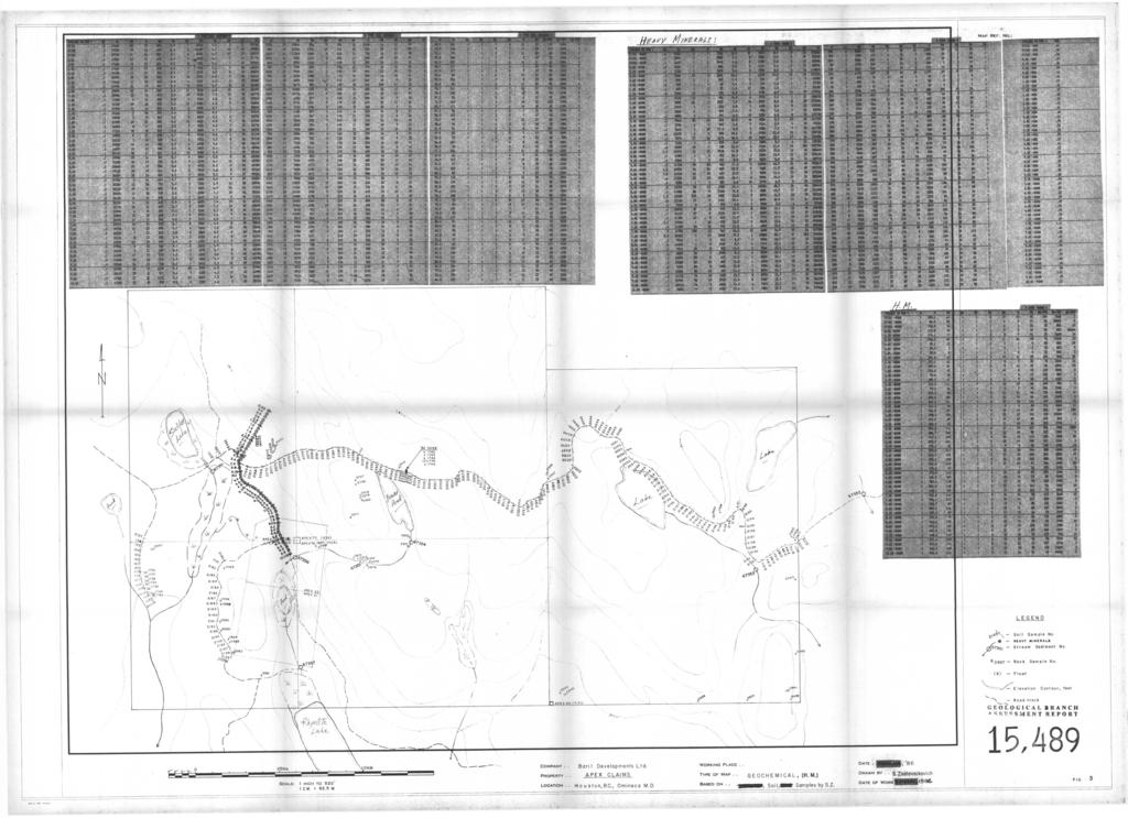
2 Page 1. Index Map ( Fig Claim Map ( Fig. 2 ) Introduction & Description General Geology 6i Physiography Geochemical Survey... 5 Total -80 Mesh Geochemistry Heavy Minerals Soil Geochemistry Conclusions... 9 APPENDICES Appendix I. Appendix 11. Appendix 111. Statement of Expenses Statement of Qualifications Analytical Procedure & Heavy Minerals Processing MAPS Scale 1:6,250 Geochemical Map, with topography and claim outlines, sample location numbers and analytical results for Apex Group Claims ( Fig. 3 )... in pocket
3
4 Q d
5 The APEX group of mineral claims, containing 39 units and owned by Baril Developments Ltd., consists of the Apex75 (4 units), Apex76 (6 units), Apex77 (9 units), Apex78 (6 units), Apex21t22 (1 unit each), and Apex85 (12 units). The claim group is located 13 km northeast of Houston, in the Omineca Mining Division, N.T.S. 93L/8W. The Apex 85 claim was staked in July 1985, while the rest of the claims in the group were staked in the early to mid seventies, at which time some prospecting, mapping, soil sampling and magnetometer work was done ( see Assesment Report #05288 Nov'74, by J. McAndrew). In 1977 the Apex claims were optioned by Conwest Exploration Co. Ltd., who conducted geophysical Induced Polarization and Resistivity surveys on the property (Assmnt.Rep. #6427). A central resistivity high was identified trending north-south through the middle of claims, with attendent I.P. probable-category anomalies on its flanks. Following stream sediment, rock and soil sampling survey in 1985 (Assesment Report, Sept'861, in October the writer collected 54 large 2kg samples of the B and C-horizon soils at 20m intervals along a north-south intersection between two previously sampled areas, as outlined on the geochemical sample location map (Fig. 3, in pocket), in order to investigate the usefullness of analyzing the Heavy Minerals fraction to help in geochemical evaluation of the mineralization potential of the Apex property. For comparison, the total -80 Mesh fraction of the soil samples was analyzed as well.
6 4 Access to the claim group Is from Houston via Hwy 16 for 8km east to Knockholt landing, then 6km south on Atkiens Ck road, and 4km east on the old homestead roads to the western edge of the property. An old east-west logging trail traverses through the middle of the property. GENERAL GEOLOGY & PHYSIOGRAPHY... According to the most recent geological mapping that includes the claim area, done at a scale of 1:125,000 by B.N. Church of the BCDM, t'geology of the Buck Creek Area", Map # , the Apex group claims are underlain by the early and middle Mesozoic Hazelton Group volcanic rocks, ranging from basic to intermediate to acid lavas and pyroclastics. On the map, a pair of northeast and northwest lineaments intersect in the ex- treme southwestern corner of the property. Surface prospecting located a small outcrop of gabbro approximately in the middle of the Apex76 claim. The mesozoic volcanics on the property were mapped as similar to the volcanics hosting the Equity Silver Mine, located 30km south-east. The gabbro intrusive present on Apex claims may well belong to the Eocene Goosly Lake intrusions, as mapped by Church at the Equity Mine property. The Apex group claims lie on the south slope of a 1,265m high hill south of Gilmore Lake, and almost reach the Aitken Creek valley at the 800m elevation. The total relief on the property is 300m, trending between the cliffy prominences in the north to the beaver-dammed boggy swamps in the south. The area in between is forested with pine and fir trees, and mantled in thick glacial cover.
7 5 GEOCHEMICAL SURVEY Large 2kg-size samples of the B and C-horizon soils were collected by the writer this Fall on the Apex property at cm depths using a grubhoe and a shovel in order to obtain sufficient material for processing by heavy liquids for Heavy Minerals analysis. A total of 51 soil samples was collected along a north-south intersection in the west-central claims region, as shown on the large scale sample location map, Fig. 3, at 20m intervals in a deeply overburdened area in hope of utilizing the heavy minerals to overcome the masking effect of deep glacial surficial cover in areas of possible bedrock mineralization. An old 3m deep overburden pit located near the sampled line was utilized for depth-profile orientation study by collecting three additional samples at lm depth intervals. The -80 Mesh material from the large soil samples was processed at the Min-En Laboratory in N.Vancouver by heavy liquid separation methods to obtain the -80 Mesh heavy minerals. The -80 Mesh H.M. fraction was analyzed for 30 trace and minor elements by ICP, plus mercury, total barium, and geochemical fire-gold, using standard geochemical methods described together with the heavy minerals processing procedure in Appendix I11 at the back of the report. The regular -80 Mesh fraction was analyzed as well for identical elements to provide comparison to the H.M. values, and continuity from the last year's soil sampling (Assessment Report, Sept.'86). Complete analytical results are directly inscribed on the geochemical 1:6,250 scale sample location map, Fig. 3 in pocket, as well as being enclosed at the back of the report.
8 6 At strongly anomalous sites the ICP multi-element analyical results indicate a high degree of correlation between the total -80 Mesh and the heavy mineral fractions. At sites of subtle element enrichment, however, there is much less correlation in analytical values. For gold, the total -80 Mesh fraction has proven to be almost barren, while the H.M. minerals contained one value of 36,000 ppb Au, another one 1,000 ppb Au, and several more between 20 and 200 Au. Good coincidence of anomalous gold and several of the trace elements occurs for all but the highest gold value of 36,000 ppb located at the northern end of the sample line. This is the area of a strong single-element zinc anomaly in the total -80 Mesh fraction however, whose significance and extent can only be determined by extending the sampling to the north. Likewise, the south-eastern end of the sampled line ends with multi-trace element anomalies in both fractions, necessitating as well future extention of the sampled line southwesterly. Total -80 Mesh Soil Geochemistry Despite the thick glacial cover, subtle yet distinguishable multi trace elements anomalies occur in the total -80 Mesh fraction at several intervals along the sampled line. At 1.4s to 1.6s enrichments of arsenic, berrilium, bismuth, cadmium, copper, antimony and mercury occur while at 5.6s to 6.25s elevaled values in barium, cadmium, copper, nickel and zinc are present. From 9.4s to 10.0 at the end of the line a stronger anomaly in arsenic, barium, cadmium, copper and zinc needs to be followed up, while at the opposite
9 7 end of the line from 0.0s to 0.6s a strong single-element zinc anomaly needs investigating further uphill. This is the only trace element anomaly not confirmed in the heavy minerals, therefore it is likely hydromorphic in nature and its source may well lie at some distance uphill from the northern end of the sampled line. Only negligible gold values of less than 10 ppb were obtained in this fraction. Heavy Minerals Soil Geochemistry-... The -80 Mesh heavy minerals soil separates contained a single extremely high gold value of 36,000 ppb Au, or just over 1 oz/ton, in the uppermost sample at 0.0s. As the analytical results on Fig. 3 indicate, the next best value was 1,000 ppb Au at 4.4S, with eight more values ranging from 20 to 200 ppb Au present. The presence of these significant gold values, in contrast to the total -80 Mesh analysis, indicates the need for heavy minerals preconcentration of the soil samples prior to analysis for gold. Because there is no corresponding trace elements anomaly in the heavies, the single extremely high gold value is likely due to glacial placering, and may be only coincidental with the total-fraction single-element zinc anomaly in the same area. The rest of the anomalous gold values are associated with trace element enrichments in the heavy minerals. Except for the zinc anomaly at 0.0s to l.os, all the rest of trace elemental enrichments in the total-80 Mesh size are confirmed and amplified in the heavy mineral fraction, as illustrated by the analytical values in Fig. 3. Additional multi trace element anomalies in the heavies occur at 0.4s
10 8 in Ba, Gd, Sb; from 3.2s to 3.48 in As, Be, Cd, sb, and Hg; at 3.8s to 4.8s in Ag, As, Be, Cd, Cu, Pb, Sb, Zn and Hg. Strongest values in the heavies occur at 7.6s in all of the trace elements and most of the minor elements, which suggests proximity to mineralized bedrock, or a mineralizing fracture or shear zone. The three pit samples taken at lm, 2m, and 3m, depths did not carry any gold in either fraction. Because the trace elements were also non-anomalous, no meaningful relationships could be established from the analytical values beyond consistent increase in barium values with depth in the heavy minerals fraction.
11 9 CONCLUSIONS Despite the thick overburden cover, several multi trace element anomalies in soils have been located in both the total and the heavy minerals -80 mesh fractions along the sampled line. 2. The total -80 mesh fraction is adequate for ICP trace element analysis, while heavy mineral pre-concentration is needed prior to geochemical analysis for gold. 3. Two of the trace element anomalies, particulary in the heavy minerals fraction, located at s and at 9.4s to the end of the line at lo.os, coincide with I.P. anomalies from earlier Assessment Reports, and need to be followed up. 4. Additional sampling at both ends of the sampled line, as well as on neighbouring soil lines, is needed to determine the extent of the soil anomalies identified in this survey.
12 APPEND I APPEND I X 1 APPREND I X 1 1 APPRENDIX 111 Statement of Expenditures Statement of Qualifications Analytical Procedures
13 APPENDIX I. Geochemistry Salaries- S. Zastavnikovich, geochemist Oct , 2 $250/day Food- 2 $25/day Travel- Motel & camp equip., 2 nights Vehicle, 4x4 truck, 2 $35/day Gas(S60.00) & Mileage 1Oc) Field Supplies- Sample bags, topofil, flagging, Sample Delivery soils, Heavy Liquid ZO.OO/sample 54 soils for 30 element ICP, Hg, Au, total Ba & 23.60/sample 54 soils, Heavy Minerals, for 30 element ICP, Hy, AU, tcrtal Ba, ( per 5aIfiple 2,160.OO 1, Report Preparation _----- Writing, drafting, filing, 2 1/2 $200 Report typing Maps reproduction and report duplication Recording trip, 2Oc & parking Total Expenditures ,214.90
14 .,..... APPENDIX I1 I.- Sam zastavnikovich, do hereby certify that: 1. I am a graduate of the University of Alberta with the Degree of B. Ed. in Physical Sciences, I have been a practicing exploration geochanist with Falcanbridge Ltd. of Toranto and Vancouver for thirteen cantinmus years as: : Field geochau 'St, international : Project cjeologist-geochemist, B. C : Exploration geochanist, mrldwide, where I was engaged in all aspects of geochemical exploration, including research and develwnt of improved sarrpling wchniques, and advanced geocherm 'cal interpretation, as well as the writing of final, budget, and assessnent repas. 3. I am a voting member of the Association of Explaratian Geochemists * 4. I am a consulting geochemist with offices at th. St., Delta, B. C.
15 APPEHDIX 111. Analytical Procedure - The sanples were analyzed by Yiin-Zn Laboratories Ltd. of 705 West 15th St., N.Vanc, as follows: The stream sediments were oven-dried in their original water-resistant haft paper bags at 95 C and screened to obtain the minus 80 mesh fraction for analysis. The rock samples were crushed and pulverized in a ceramic-plated pulverizer. A suitable weight og 5.0 or 10.0 grams is pretreated with HNO3 and HClO4 mixture. After pretreatment the samples are digested with Aqua Regia solution, then taken up with 25% HC1 to suitable volume and aliquot used for the 26 element ICP trace element analysis. From the major remaining portion of the sample, Gold is preconcentrated by standard fire assay methods, then extracted with Methyl Iso-Butyl Ketone and analyzed by Atomic Absorption. For Mercury analysis, 1 gram of sieved material is sintered at 90 c for 4 hours, then digested in HN03 and HC1 acids mixture, and analyzed by the Hatch and Ott flameless AB method.
16 PHONE: (604) or APPENDIX I11 TELEX: MIN- EN Laboratories Ltd. Specialisrs in Mineral Environrnenrs Corner 15th Street end Bewicke 705 WEST 15TH STREET NORTH VANCOUVER, B.C. CANADA V7M lt2 ASSESSMENT REPORT FOR: HEAVY MINERAL SAMPLING AND CONCENTRATIONS A large sam@le is collected from stream sediments or soils big enough to yield a minimum of 0.5 kg of the desired minus fraction, After sieving through any of the sieve mesh sizes they are adapted for the survey. After seiving the samples, the minus fraction is grinded to -80 mesh. Then 0-4 kg of sample is weighed into a suitable centrifuge containers. The prepared concentrations of liquids are added to obtain a 3.1 specific gravity flotation. - The heavy fractions are then washed cleaned and dried. After drying the samples they are separated, The sink float Heavy Minerals are separated into Magnetic and Non Magnetic fractions and both fractions are weighed. The percent of the Magnetic and non Magnetic fractions are calculated and reported with the analytical data. The analysis are than carried out in the ususal analytical manner by I.C.P. or A.A. method.
17
UNION MINIERE EXPLORATIONS AND MINING CORPORATION LIMITED ASSESSMENT REPORT ON FITINAT MINERAL CLAIM. Alberni Mining Division Record No.
 M F )( UNION MINIERE EXPLORATIONS AND MINING CORPORATION LIMITED Suite 200, 4299 Canada Way, Burnaby, B.C. V5G 1 H4 Telephone (604) 437-9491 ASSESSMENT REPORT ON GEOCHEMICAL SOIL SURVEYS AND ROCKSAMPLING
RECONNAISSANCE GEOCHEMICAL SURVEY
 RECONNAISSANCE GEOCHEMICAL SURVEY LEGAL, RITA, LOUISE FR. (CHAPLEAU GROUP) REVERTED CROWN GRANTS CHAPLEAU CREEK AREAJ, SLOC& MINING DIVISION 82 F/11W Lat: 49'44" Long: 117"22'W MINERAL RESOURCES BRANCH
49" 3-4 I4 I \ Y 59 tj
 ASSESSMENT REPORT Mary 4 FORT STEELE M.D. NTS 82G/5W 49" 3-4 4 \ Y 59 tj Owner: St. Eugene Mining Corporation Limited Operator : St. Eugene Mining Corporation Limited Author: John R. Wilson Date Submitted:
REPORT SOIL GEOCHEMICAL SURVEY. ATTYCELLEY NO. 2 GROUP (Attycelley Mineral Claims No. 7-10)
") REPORT SOIL GEOCHEMICAL SURVEY ATTYCELLEY NO. 2 GROUP (Attycelley Mineral Claims No. 7-10) Situated 7 miles east of north end of Thutade Lake, Omineca Mining Division British Columbia I Department of I
REPORT SOIL GEOCHEMICAL SURVEY ATTYCELLEY NO. 2 GROUP (Attycelley Mineral Claims No. 7-10) Situated 7 miles east of north end of Thutade Lake, Omineca Mining Division British Columbia I Department of I
GEOCHEMICAL REPORT. Skeena M.D. Latitude Longitude G-4Yd N.T.S. September 18-29, 1979
 GEOCHEMCAL REPORT On the QCSZ Claims Group (Snow #3 64 Claims) Skeena M.D. Latitude 53 13 Longitude 131 49 N.T.S. 103-G-4Yd September 18-29, 1979 Vancouver, B. C. January, 1980 S. Zastavnikovich TABLE
PRECIOUS METALS. owner. JMT Services Corp. GEOCHPlICAL SAMPLING CHELASLIE WCE, NORTH CENTRAL, B.C. OMINECA MINING DIVISION NTS 93F/5E & 6W
 PRECIOUS METALS REPORT ON 1980 RECONNAISSANCE GEOCHPlICAL SAMPLING CHELASLIE WCE, NORTH CENTRAL, B.C. OMINECA MINING DIVISION NTS 93F/5E & 6W LATITUDE 53O28 N LONGITUDE 125O31 W DATES Qp WORK: JULY 10
SECOND and THIRD YEAR ASSESSMENT REPORT PROSPECTING LICENCE M, ROCK CUT PROPERTY, NTS 1N/12, NEWFOUNDLAND. ROY FRENCH (licence holder )
") SECOND and THIRD YEAR ASSESSMENT REPORT Of PROSPECTING On LICENCE 013704M, ROCK CUT PROPERTY, NTS 1N/12, NEWFOUNDLAND. By ROY FRENCH (licence holder ) Work Conducted: Sept. 17, 2008 Nov. 03, 2009 Total
SECOND and THIRD YEAR ASSESSMENT REPORT Of PROSPECTING On LICENCE 013704M, ROCK CUT PROPERTY, NTS 1N/12, NEWFOUNDLAND. By ROY FRENCH (licence holder ) Work Conducted: Sept. 17, 2008 Nov. 03, 2009 Total
for the Greenwood Mining Division, B.C. NTS 82E/7W Latitude 49' 27' W, Longitude 118' 5 Prepared by a= D. Dylan Watt, B.Sc.
 t. b LOGnO: 37~ -08 m. ACTIO#: for the AMP AMP 2 AMP 3 t AMP 4 CLAIMS Greenwood Mining Division, B.C. NTS 82E/7W Latitude 49' 27' W, Longitude 8' 5 %E c,w zc *& a w Prepared by a= -4c. D. Dylan Watt, B.Sc.
BALFOUR MINING LTD. (N.P.L.) HAM GROUP 92-P-6, CLINTON M. D.8 B. C. Lat 51 17'N, GEOCHEMICAL REPORT. V. CUKOR, P. Eng.
 HAM GROUP 92-P-6, CLINTON M. D.8 B. C. Lat 51 17'N, GEOCHEMICAL REPORT. V. CUKOR, P. Eng.") 34q '7 BALFOUR MINING LTD. (N.P.L.) HAM GROUP 92-P-6, CLINTON M. D.8 B. C. Lat 51 17'N, Long 12lo14'W GEOCHEMICAL REPORT, V. CUKOR, P. Eng. January 31, 1972 TABLE OF CONTENTS 1. INTRODUCTION 2. PROPERTY,
34q '7 BALFOUR MINING LTD. (N.P.L.) HAM GROUP 92-P-6, CLINTON M. D.8 B. C. Lat 51 17'N, Long 12lo14'W GEOCHEMICAL REPORT, V. CUKOR, P. Eng. January 31, 1972 TABLE OF CONTENTS 1. INTRODUCTION 2. PROPERTY,
MtNERAL EXPLORATION CONSULTANTS ASSESSMENT REPORT MT. MILLIGAN AREA OMINECA M.D. Latitude: 55' 07' N Longitude: 123" 56' W NTS : 93 0/4 W.
 D. L. COOKE AND ASSOCIATES LTD. MtNERAL EXPLORATION CONSULTANTS ASSESSMENT REPORT 1989 PRELIMINARY GEOCHEMICAL SURVEY KC MINERAL CLAIMS MT. MILLIGAN AREA OMINECA M.D. Latitude: 55' 07' N Longitude: 123"
6. E. Spencer Engineering Ltd. '1 iias k*-&-!
 6. E. Spencer Engineering Ltd. '1 iias k*-&-! CONSULTING GEOLOGICAL ENGINEER REPORT ON A GEOCHEMICAL SOIL SURVEY ON THE AXL 3 MINERAL CLAIM KAMLOOPS MINING DIVISION, N.T.S. 82,M/4 LATITUDE: 51O N, LONGITUDE:
Cominco ltd. REPORT OF GRID "C" GEOCHEMICAL SURVEY ON VINE 1 CLAIM, VINE 1, 25, 27 CLAIM GROUP Fort Steele Mining Division
 GOVERNMENT OFFICE Cominco ltd. EXPLORATION DIVISION REPORT OF GRID "C" GEOCHEMICAL SURVEY ON VINE 1 CLAIM, VINE 1, 25, 27 CLAIM GROUP Fort Steele Mining Division Submitted by: E.W. BATCHELOR Cominco Ltd.
Daiwan Engineering Ltd Granville strees V.ncouver, B. C. cuudr WY 1GS. M e : (604) PROSPECTING REPORT ON THE KING MINERAL CLAIMS
 PROSPECTING REPORT ON THE KING MINERAL CLAIMS") 1030-609 Granville strees V.ncouver, B. C. cuudr WY 1GS M e : (604) 688-1508 PROSPECTING REPORT ON THE KING MINERAL CLAIMS NORTH VANCOUVER ISLAND, BRITISH COLUMBIA NTS: 92Lj13E Latitude: 50" 47' Longitude:
1030-609 Granville strees V.ncouver, B. C. cuudr WY 1GS M e : (604) 688-1508 PROSPECTING REPORT ON THE KING MINERAL CLAIMS NORTH VANCOUVER ISLAND, BRITISH COLUMBIA NTS: 92Lj13E Latitude: 50" 47' Longitude:
ASSESSMENT REPORT GEOLOGICAL BRANCH. 50' 23 'North. GEOLOGICAL and GEOCHEMICAL SURVEYS ON THE. PUTNAM PROPERTY (Putnam Mineral Claim)
") GEOLOGICAL and GEOCHEMICAL SURVEYS ON THE PUTNAM PROPERTY (Putnam Mineral Claim) VERNON MINING DIVISION, B.C. GEOLOGICAL BRANCH ASSESSMENT REPORT NTS : Latitude: 82L17W 50' 23 'North LOCATION, ACCESS,
GEOLOGICAL and GEOCHEMICAL SURVEYS ON THE PUTNAM PROPERTY (Putnam Mineral Claim) VERNON MINING DIVISION, B.C. GEOLOGICAL BRANCH ASSESSMENT REPORT NTS : Latitude: 82L17W 50' 23 'North LOCATION, ACCESS,
SOIL GEOCHEMISTRY. OK-ll AND OK-Ill MINERAL CLAIMS MOUNT THOEN AREA OMINECA MINING DIVISION, B.C. NTS 93 MI6 E & 7 W
 SOIL GEOCHEMISTRY OK-ll AND OK-Ill MINERAL CLAIMS MOUNT THOEN AREA OMINECA MINING DIVISION, B.C. NTS 93 MI6 E & 7 W LATITUDE 55O23'N, LONGITUDE 127 01W Locke B. Goldsmith, P.Eng. Consulting Geologist December
ASSESShAENT REPORT Mines and Petroleum Resources. Department of. No* JIMMY MINERAL CLAIM FRANKLIN CREEK AREA, GREENWOOD M. D.
 GEOCHEMICAL REPORT ON JIMMY MINERAL CLAIM FRANKLIN CREEK AREA, GREENWOOD M. D. Lat. 49'35' OON, N.T.S. Long. 118O22' 00W 82-E-9 July 18-21, 1974 Vancouver, B.C. J.J. McDougall, P.Eng. July 21, 1974 * Department
GRANGES EXPLORATION AB CANADIAN DIVISION
 GRANGES EXPLORATON AB CANADAN DVSON GEOCHEMCAL REPORT ON "B" and "D" CLAMS OMNECA MNNG DEVSON FAWNE NOSE AREA LATTUDE: 53O 19' LONGTUDE: 125O 1' MNERAL RESOURCES BRANCH N.T.S 93F/6 E Owner and Operator
PHYSICAL WORK REPORT. the BAY CLAIMS. Omineca Mining Division Smithers, British Columbia N.T.S. 93E 13E/W
 PHYSICAL WORK REPORT the BAY CLAIMS Omineca Mining Division Smithers, British Columbia a N.T.S. 93E 13E/W LATITUDE: 53 57 00 N I LONGITUDE: 127 45 OO W for Home Ventures Ltd. 1201-675 West Hastings Street
ASSESSMENT REPORT ON THE PEAVINE PROJECT. DGW & Associates # Alberni Street, Vancouver, British Columbia, V6E 4V2
 ASSESSMENT REPORT ON THE PEAVINE PROJECT KAMLOOPS MINING DIVISION BRITISH COLUMBIA NTS 082M 12 Latitude 51 36' 19.0"North -- Longitude --119 47' 27.0"West UTM Zone 11, NAD 83 5720827N 306744E Prepared
GEOCSZNICAL - SURVEY. ICAMLOOPS Kl.D. 2'' 6;kr. HY "'f. Alfred R. Allen,P.Eng. 1 NO.%=...,... 6"- 'I.
 t i.i GEOCSZNICAL - SURVEY i p' ICAMLOOPS Kl.D. 2'' 6;kr HY 50-64 +."'f 121-51 NE 5-10-70 : 19-10-70 Alfred R. Allen,P.Eng. I) ' 1 6"- 'I. 1 NO.%=...,..... Q.C. EXPLORATIONS LTD. 2Cl- 535 Kowe Street Vancouver
The Cobalt Rainbow. Airborne geophysical maps show that a north trending aeromagnetic high suggests further undiscovered mineralisation.
 The Cobalt Rainbow The property is located on Greenstone Creek, approximately 4.8 kilometres south west of the creek mouth. The property is located about 24 km due west of Campbell River, in the east-central
for the Greenwood Mining Division, B.C. NTS 82E/7W 29' W, Longitude 118' 53' N Prepared by D. Dylan Watt, B.Sc.
 for the FltE NO: u VOLT 1, VOLT 2, VOLT 3, & VOLT 4 CLAIMS Greenwood Mining Division, B.C. NTS 82E/7W Latitude 49' 29' W, Longitude 118' 53' N Prepared by D. Dylan Watt, B.Sc. #309-1996 Trutch Street Vancouver,
COMINCO LTD. GRID A VINE CLAIM GROUP. Fort Steele Mining Division 82G/5. Sulilnit t ed by :
 COMNCO LTD. EXPLORATON DVSON WESTERN DSTRCT REPORT ON GEOCHEMCAL SURVEY GRD A VNE CLAM GROUP Fort Steele Mining Division 82G/5 Sulilnit t ed by : E.W. BATCHELOR Cominco Ltd. Kootenay Exploration 2450 Cranbrook
Serengeti Resources Inc GEOCHEMICAL REPORT ON THE SHADOW PROPERTY a.
 Serengeti Resources Inc. 2004 GEOCHEMICAL REPORT ON THE SHADOW PROPERTY a. Located in the Johanson Lake Area Omenica Mining Division NTS 94D/9 6 degrees and 32 minutes North Latitude 126 degrees and 2
TERA 1-4; reccrd no s Clifford McNeill TENA 5-10; record no s Owner: lrnest G. Olfert
 GEOCHENIC-:-I, SURVEY REPORT ON MINXAL CLAIMS TERA 1-4; reccrd no s 9107-9110 Owner: Clifford McNeill TENA 5-10; record no s 9399-9404 Owner: lrnest G. Olfert Located in the Orineca Mining Division of
ASSESSMENT REPORT. Geochemical and Geological Surveys. on the. Gooch#1-4. Mineral Claims. Omenica Mining District NTS 93L/7W
 f- GEOLOGICAL BRANCH ASSESSMENT REPORT ASSESSMENT REPORT Geochemical and Geological Surveys on the Gooch#1-4 Mineral Claims Omenica Mining District NTS 93L/7W LAT: 54O25'W LONG: 126O26'W Operator: SMD
GEOCHEMICAL REPORT LAST LINK GROUP TEXADA ISLAND NANAIMO MINING DIVISION
 I GEOCHEMICAL REPORT LAST LINK GROUP TEXADA ISLAND NANAIMO MINING DIVISION -1- PROSPECTING & GEOCHEMICAL SOIL SURVEY FOR GOLD On the Last Link Group of Claims North End of Texada Island Nanaimo Mining
51 46'N Latitude, 119'44'1;!
 COMI)!CO LTD. EXPLORATION NTS: 82 1'1/13E GEOCHEKICAL ASSESSMENT REPORT ON THE SI 1 MINERAL CLAIM in the Kamloops Mining Division 51 46'N Latitude, 119'44'1;! Longitude Work Period: June 25, 1979 - July
NTS 93L/9W GEOCHEMICAL AND GEOPHYSICAL REPORT MONA CLAIM OMINICA MINING DIVISION. Lati tude 54036'N; Longitude 'W
 GEOCHEMICAL AND GEOPHYSICAL REPORT ON MONA CLAIM OMINICA MINING DIVISION Lati tude 54036'N; Longitude 126018'W NTS 93L/9W April 1981 Paul Plicka Consulting Geologist LOCATION MAP INTRODUCTION TABLE OF
490 20' 30" North Latitude ' 30" West Longitude
 _._.. I CONSULTING GEOLOGISTS 605-602 WEST HASTINGS STREET, VANCOUVER, B.C. V6B 1P2 TELEPHONE: (604) 689-5533 6 I F: ASSESSMENT REPORT ON THE PATSY 1 MINERAL CLAIM ' '?%2% I WHISTLE CREEK, HEDLEY ARE L-l-
GEOLOGICAL BRANCH ASSESSMTNF REPORT
 A GEOCHEMICAL REPORT on the 49 CR. GROUP APPROX. 9 mi SW OF NELSON, B.C 49 CREEK AREA NELSON NINING DIVISION BRITISH COLUNBIA NINERAL CLAIM MAP N. T.S. 82-~/6 WEST LATITUDE$ 49' 27'~ LONGITUDE : 117' 2j0w
R.A. COMINCO LTD. EXPLORATION NTS: 92H/16. WESTERN DISTRICT January 6, 1982 ASSESSMENT REPORT 1981 SOIL GEOCHEMISTRY ON THE TROUT PROPERTY
 COMINCO LTD. EXPLORATION NTS: 92H/16 WESTERN DISTRICT January 6, 1982 ASSESSMENT REPORT 1981 SOIL GEOCHEMISTRY ON THE TROUT PROPERTY (Trout 1 and 6 Claims) SIWASH LAKE AREA, SIMILKAMEEN M.D., B.C. (Work
GEOCHEMICAL STREAM SAMPLING. on the PLACER LEASES NO. Jordan River/Bear Creek Area. Victoria Mining Division. Latitude 48 degrees 32 minutes N.T.S.
 GEOCHEMCAL STREAM SAMPLNG on the PLACER LEASES NO P. 8149, 8150, 8151, 8152, 8161, 8162, 8163, 8400, 10844, 10845 Jordan River/Bear Creek Area Victoria Mining Division Latitude 48 degrees 32 minutes Longitude
GEOLOGICAL MAPPING REPORT ON THE ASH MINERAL CLAIM OSOYOOS MINING DIVISION ASHNOLA RIVER MAP SHEET NTS M092,H019 MCBRIDE CREEK AREA, ASHNOLA RIVER,
 GEOLOGICAL MAPPING REPORT ON THE ASH MINERAL CLAIM OSOYOOS MINING DIVISION ASHNOLA RIVER MAP SHEET NTS M092,H019 LATITUDE 49 o O6, LONGITUDE 120 o 22 MCBRIDE CREEK AREA, ASHNOLA RIVER, KEREMEOS, B.C. CANADA
FOLLOW-UP GEOCHEMICAL REPORT ON THE PM CLAIM OMINECA MINING DIVISION N.T.S. 93 5/ degrees 123 degrees
 FOLLOW-UP GEOCHEMICAL REPORT ON THE PM CLAIM OMINECA MINING DIVISION N.T.S. 93 5/3 PO mm w o Latitude: Longitude: 54 degrees 3 degrees 59" 44'W NORANDA EXPLORATION COMPANY, LIMITED (NO PERSONAL LIABILITY)
GEOLOGICAL BRANCH ASSESSMENT REPORT 12. FItE NO: ACTION: THE GOLDEN MINING DIVISION, GOLDEN, Including THE NTS MAP; M82K/15W
 ACTION: FItE NO: Including 1990 GEO-CHEM SURVEY RESULTS -- THE AVD CLAIMS - THE GOLDEN MINING DIVISION, GOLDEN, B.C. NTS MAP; M82K/15W Lat. 50 deg. 55 Min. Long 116 deg. 55 min. For GEOLOGICAL BRANCH ASSESSMENT
We are committed to providing accessible customer service. If you need accessible formats or communications supports, please contact us.
 We are committed to providing accessible customer service. If you need accessible formats or communications supports, please contact us. Nous tenons à améliorer l accessibilité des services à la clientèle.
- LONGITUDE : 128'06 'W
 COMINCO LTD. WESTERN DISTRICT MARCH 1977 SOIL GEOCHEMICAL SURVEY SAND 1 and SAND 2 CLAIMS HIDDEN VALLEY AREA LIARD MINING DIVISION LATITUDE : 59'03' - LONGITUDE : 128'06 'W JUNE 20/76-JULY 12/76 REPORT
PROSPECTORS ASSISTANCE PROGRAM MINISTRY OF ENERGY AND MINES
 BRITISH COLUMBIA PROSPECTORS ASSISTANCE PROGRAM MINISTRY OF ENERGY AND MINES GEOLOGICAL SURVEY BRANCH PROGRAM YEAR: 1999/2000 REPORT #: PAP 99-l 6 NAME: KIM ANSCHETZ PROSPECTORS TlEPORT on the 99 LOUIS
PROSPECTING REPORT THE WALLACE CLAIM OMENICA MINING DIVISION. 54" x6" 3.d d. for. Reako Exlorat ions Ltd. Wallace Rev. C.G.
 PROSPECTING REPORT ON THE WALLACE CLAIM OMENICA MINING DIVISION 54"44 14 1x6" 3.d d by David A. Howard P.Eng. for Reako Exlorat ions Ltd. Claim Locat ion Wallace Rev. C.G. #1560 Dome Mountain Area 9 3
58 l'gr'n 'E. Date: January 23, 1979 ASSESSMENT REPORT PLACER SAMPLING & JADE BOULDER EVALUATION PLACER LEASE Liard Mining Divison 1041/7E
 ASSESSMENT REPORT PLACER SAMPLING & JADE BOULDER EVALUATION PLACER LEASE 1711 Liard Mining Divison 1041/7E 58 l'gr'n 18 38'E Owner & operator: Cry Lake Jade Mines Ltd. Author: A.M. Homenuke, P.Eng. Date:
%+ '$# $) %, %*$ " $ $ ' %' !()'-!" %( %"%! " *'+ - % %$! $)! " $)!" !$ ' "! )( ! $ '%& ')- % % "!#( (( ((# $) ' ) ((* & *# ' % %"*# ( !!
 %, %*$ $ $ ' %' !()'-! %( %%! *'+ - % %$! $)! $)! !$ ' ! )( ! $ '%& ')- % % !#( (( ((# $) ' ) ((* & *# ' % %*# ( !!") 001L/14/0218 First Year Assessment Report of Prospecting, Rock and Stream Sediment Sampling On Licence 18880M, NTS 1L/14 Burin Peninsula Newfoundland and Labrador Submitted by: Keith Kelloway Work year:
001L/14/0218 First Year Assessment Report of Prospecting, Rock and Stream Sediment Sampling On Licence 18880M, NTS 1L/14 Burin Peninsula Newfoundland and Labrador Submitted by: Keith Kelloway Work year:
Lat. 52' 43' N Long ' W
 &A exploration ltd MINING ENGINEERING GEOLOGY- GEOPHYSICS 4570 HOSKINS ROAD, NORTH VANCOUVER, 6. C. TELEPHONE (804) 985,7921 V7K 2R1 GEOLOGICAL AND GEOCHEMICAL REPORT on the BLUE CLAIMS Cariboo Mining
003Y30RN W
 W ENGINEER CLAIMS REPORT ON PRELIMINARY GEOLOGICAL MAPPING AND GEOCHEMICAL SAMPLING ENGINEER 1,2,3, dt 4 CLAIMS LILLOOET MINING DIVISION NTS MAP SHEET 92511 E - ; 003Y30RN 123001 15 W I AND PETROLEUM RESOURCES
PROSPECTING REPORT. Broken Hill Property. EVENT # TENURE # Tenure Name: Broken Hill. New Westminster Mining Division Map 092H
 2009-2010 PROSPECTING REPORT Broken Hill Property EVENT # 4514071 TENURE # 600988 Tenure Name: Broken Hill New Westminster Mining Division Map 092H Central Coordinate Reference 121 24 26.2 W Longitude
Geochemical Assessment Report. on the. Situated Nineteen Kilometres rth-northeast of Hope, B. C. in the. New Westminster Mining Division
 7 I Geochemical Assessment Report r on the r- I 1 Norm 1 to Norm 4 Mineral Claims c - I - 7 Situated Nineteen Kilometres rth-northeast of Hope, B. C. in the New Westminster Mining Division itude 49*32'N.,
MAYO LAKE MINERALS INC
 MAYO LAKE MINERALS INC FOR IMMEDIATE RELEASE Press release 2014-05 Gold-Arsenic-Antimony Anomalies on Anderson Claim Group Follow-up Sampling on Davidson, Edmonton and Roop Claim Groups OTTAWA, ONTARIO,
GEOCHEMICAL REPORT ON THE YEP CLAIMS, Clinton Mining Division. P.E. Fox, PhD. P.Eng.
 CLNTON 1 MNNG RECORDER GEOCHEMCAL REPORT ON THE YEP CLAMS, Clinton Mining Division P.E. Fox, PhD. P.Eng. Fox Geological Consultants Ltd 204-635 Victoria St. Kamloops, B. C. August 5, 1974 Work done: Juge
Goliath Reports Grams Per Tonne Gold Equivalent Over 2 Metres Channel Cut at Golddigger in the Golden Triangle; Bulk Sample Recommended
 Goliath Reports 22.83 Grams Per Tonne Gold Equivalent Over 2 Metres Channel Cut at Golddigger in the Golden Triangle; Bulk Sample Recommended November 28, 2017 Goliath Resources Ltd. (TSX-V: GOT) (the
W. 1.NELSON Jr. P. ENG.
 GEOCHEMICAL AND GEOPHYSICAL SURVEY SNO GROUP CLAIMS W. 1.NELSON Jr. P. ENG. NORANDA EXPLORATION COMPANY, LIMITED OMINECA MINING DIVISION AUG. 17, 1971 - AUG. 29, 1971 TABLE OF CONTENTS - Page INTRODUCTION
m7m NO..._.. _... SELCO MINING CORPORATION LIMITED REPORT ON GEOCHEMICAL RECONNAISSANCE SOKEREIGN CREEK ... MAP
 u u 428.7 u U SELCO MNNG CORPORATON LMTED REPORT ON GEOCHEMCAL RECONNASSANCE AT m7m SOKEREGN CREEK u 0 0 u u u Ng7 NO...._.. _.............. MAP...-......- GEOLOGCAL RECONNASSANCE AT SOVEREGN CREEK, B.C.
REPORT ON MAGNETOMETER SURVEY TIK-1 CLAIM e&f KAMLOOPS MINING DTVISION. by D. Hendry D. C. MILLER. February 3, for
 REPORT ON MAGNETOMETER SURVEY TIK-1 CLAIM 92-1-14 e&f KAMLOOPS MINING DTVISION lat. 50 57 ' 12" long. 121O23 ' 37" OWNER: ST. JOSEPH EXPLORATIONS LIMITED OPERATIOR: ST. JOSEPH EXPLORATIONS LIMITED by D.
OPERATOR: Du Pont of Canada Exploration Limited DU PONT OF CANADA EXPLORATION LIMITED GEOLOGICAL AND GEOCHEMICAL REPORT ON THE BAX CLAIMS
 DU PONT OF CANADA EXPLORATION LIMITED GEOLOGICAL AND GEOCHEMICAL REPORT ON THE BAX CLAIMS LIARD MINING DIVISIOM LAT. 56O42'N, LONG. 13Oo59'W NTS: 104-B-10W OWNER OF CLAIMS: Du Pont of Canada Exploration
ASSESSMENT' REPORT GEOPHYSICAL REPORT ON THE ATTORNEY 2 CLAIM (4 UNITS) OMINECA MINING DIVISION SHEILA A. CRAWFORD.
 OMINECA MINING DIVISION SHEILA A. CRAWFORD.") ASSESSMENT' REPORT GEOPHYSICAL REPORT ON THE ATTORNEY 2 CLAIM (4 UNITS) OMINECA MINING DIVISION by SHEILA A. CRAWFORD LOCATION: 57z17' N Latitude 127 11' W Longitude N.T.S. 94E/6E OWNER/OPERATOR: SEREM
ASSESSMENT' REPORT GEOPHYSICAL REPORT ON THE ATTORNEY 2 CLAIM (4 UNITS) OMINECA MINING DIVISION by SHEILA A. CRAWFORD LOCATION: 57z17' N Latitude 127 11' W Longitude N.T.S. 94E/6E OWNER/OPERATOR: SEREM
FILE NO. ASSESSMENT REPORT VLF-EM GEOPHY S I CS BUCK CLAIMS. Moyie River and Perry Creek Area FORT STEELE MINING DIVISION. NTS 82 F/8 E and 82 G/5 W
 FILE NO. ASSESSMENT REPORT on - VLF-EM GEOPHY S I CS BUCK CLAIMS Moyie River and Perry Creek Area FORT STEELE MINING DIVISION NTS 82 F/8 E and 82 G/5 W Latitude 49 27' N Longitude 116 03' W PETER KLEWCHUK
DSM SYNDICATE DISCOVERS POLYMETALLIC MINERALIZATION WITH TALUS GRAB SAMPLES CONTAINING UP TO PERCENT LEAD AND 18
 DSM SYNDICATE DISCOVERS POLYMETALLIC MINERALIZATION WITH TALUS GRAB SAMPLES CONTAINING UP TO 92.8 GRAMS PER TONNE GOLD, 13,643 GRAMS PER TONNE SILVER, 13.85 PERCENT LEAD AND 18.65 PERCENT COPPER FROM DIFFERENT
SOIL GEOCHEMISTRY ENTERPRISE MINE NTS 82 F/14 W ARCTEX ENGINEERING SERVICES CONSULTANT, OWNER, OPERATOR, AUTHOR JANUARY, 1.981
 SOIL GEOCHEMISTRY ENTERPRISE MINE t SLOCAN MINING DIVISION, Bn C, NTS 82 F/14 W LATITUDE 49'49') LONGITUDE 1'19' ARCTEX ENGINEERING SERVICES I L, B, GOLDSMITH, PiENG, CONSULTANT, OWNER, OPERATOR, AUTHOR
1 FILMED 1. FILE NO:!..rsrru -* -. GRAND TWO CLAIM
 FILE NO:!..rsrru -* -. GRAND TWO CLAIM REPORT ON 1993 ASSESSMENT WORK GRAND TWO CLAIM REC. NO. 301849 NELSON MINING DIVISION NTS MAP SHEET 82F6/W 49 25'51" NORTH 117 18'08" WEST 1 FILMED 1 AUTHOR: R. Jordan,
1 CLAIMS GEOPHYSICAL REPORT ON BOYAL SITUATE NORTHEAST OF TILLICUM MOUNTAIN GOLD AREA BURTON - NAKUSP SIQCAEJ MINING DIVISION
 GEOPHYSICAL REPORT ON BOYAL 1 CLAIMS SITUATE NORTHEAST OF TILLICUM MOUNTAIN GOLD AREA BURTON - NAKUSP SIQCAEJ MINING DIVISION CONSULTING GEOLOGIST AUGUST 1983 VANCOUVER B *C INDEX INTRODUCTION ooa,.eoaaa.aaaoaaooaoa~ao~o
CONSULTING GEOLOGICAL 8: MINING ENGINEERS STINGS STREET DA V6E 2E9 GEOPHYSICAL SURVEY SILVER QUEEN 2 ZEBALLOS AREA. B.C.
 DOLMAGE CAMPBELL & ASSOCIATES (1 975) LTD. CONSULTING GEOLOGICAL 8: MINING ENGINEERS STINGS STREET DA V6E 2E9 '' 1E O L 0 G I C A.L B'x;&a:f2:#& 'SESSMENT REPObT 12, Assessment RESOURCES LTD. 111 ReDort
GEOPHYSICAL REPORT ON AN INDUCED POLAR.IZATION SURVEY
 GEOPHYSICAL REPORT ON AN INDUCED POLAR.IZATION SURVEY T & V Claim Groups some 12 miles Northwest of Babine Lake, B.C. Latitude 55' 26'N Longitude 126' 35'W AUTHOR: Glen E. White, Chief Geophysicist,a,
BEATY GEOLOGICAL LTD.
 BEATY GEOLOGICAL LTD. Contract Geological Services 208-2786 West 16th Avenue Vancouver, B.C., Canada V6K 3C4 Telephone (604) 734-2774.I REPORT ON A GEOCHEMICAL SURVEY OF THE VITAL PROPERTY, TAKLA LAKE
Prospecting Report Grandpa Claim Group
 2010 2011 Prospecting Report Grandpa Claim Group TENURE NUMBER: 705523 EVENT NUMBER: 4825383 TENURE NAME: GRANDPA Lillooet Mining Division Map 092I Central Coordinate Reference 50 57 30 N Latitude 121
NEW HAZELTON, OMINECA M.D.,
 PROSPECTING REPORT JUDI 1 TO 6 MINERAL CLAIMS NEW HAZELTON, OMINECA M.D., B.C. MAP 93M/4E, LAT. SS014'N, LONG. 127'33'W OWNED BY: A. L'ORSA ANTHONY L'ORSA Smithers, B.C. 21 February, 1981 TABLE OF CONTENTS
'-7' REPORT ON A MAGNETOMETER SURVEY OVER PART OF THE MAX CLAIM GROUP 1-20 LAC LE JEUNE AREA KAMLOOPS MINING DIVISION KAMLOOPS, BRITISH COLUMBIA
 I,., - SUITE 102. 222 BELLEVUE WES t ANCOUVER, B. '-7' REPORT ON A I MAGNETOMETER SURVEY OVER PART OF THE MAX CLAIM GROUP 1-20 LAC LE JEUNE AREA KAMLOOPS MINING DIVISION KAMLOOPS, BRITISH COLUMBIA 50-30
EXPLORATION and DEVELOPMENT REPORT. Conrad Creek. PLACER and MINERAL CLAIMS SOUTHEAST BRITISH COLUMBIA
 EXPLORATION and DEVELOPMENT REPORT on Conrad Creek PLACER and MINERAL CLAIMS in SOUTHEAST BRITISH COLUMBIA Ed Friesen, BSc.E.E., P. Eng 8 Lake Placid Rise SE Calgary, Alberta T2J 5B5 April 2009 1 P age
Prospecting Report 'S Office i DB Property, B.C. -J Negro Creek Nelson Mining District NTS 82F.050. Operator: Kootenay Gold Inc.
 . '.' I"' i9 12 Prospecting Report 'S Office i DB Property, B.C. -J Negro Creek Nelson Mining District NTS 82F.050 Operator: Kootenay Gold Inc. Owner: Darlene Lavoie Work Performed Summer of 2007 Report
UT. 56O40'N, LONG. 13Oo51'W
 DU PONT OF CANADA EXPLORATION LIMITED GEOLOGICAL AND GEOCHEMICAL REPORT ON THE ZAPPA CLAIMS LIARD MINING DIVISION UT. 56O40'N, LONG. 13Oo51'W NTS: 104-B-10W OWNER OF CLAIMS: Du Pont of Canada Exploration
R. Wares, P. Eng. (82L/5FJ) Long : 119O 59' w DRILLING REPORT. Kamloops, Mining Division. Lat : 50' 21' N. Owner: H. Adams
 Long : 119O 59' w DRILLING REPORT. Kamloops, Mining Division. Lat : 50' 21' N. Owner: H. Adams") DRILLING REPORT J.G. CLAIM Kamloops, Mining Division (82L/5FJ) Lat : 50' 21' N Long : 119O 59' w Owner: H. Adams Operator: H. Adams Box 1329 Princeton, B.C. Report: R. Wares, P. Eng. Date : 30th November
DRILLING REPORT J.G. CLAIM Kamloops, Mining Division (82L/5FJ) Lat : 50' 21' N Long : 119O 59' w Owner: H. Adams Operator: H. Adams Box 1329 Princeton, B.C. Report: R. Wares, P. Eng. Date : 30th November
NTS 082F03SW N W U E N
 Prospecting Report JOCELYN CLAIM NTS 082F03SW N49 09 51 W 117 14 04 11U 482906E 5445737N NELSON MINING DIVISION Martin Ross PO Box 323 Salmo BC V0G 1Z0 Jan 31, 2012 PROSPECTING REPORT JOCELYN MINERAL CLAIM
Precipitate s Geophysical Surveying Generates More Targets at Melchor and Peak Zones
 TSX VENTURE: PRG www.precipitategold.com 625 Howe Street, Suite 1020, Vancouver, BC, V6C 2T6 info@precipitategold.com Toll free: 855 558 0335 Direct: 604 558 0335 Precipitate s Geophysical Surveying Generates
Mines and,3efro!sgrn Resources
 on the JO ANN MINERAL C LAIMS 35 Miles Northwest of Germansen Landing, B.C. Omineca Mining Division British Columbia MineralClaimMap 93N/13E, 14W Latitude: 55O 57' Longitude: 125O 28' by Douglas Stelling,
PHYSICAL WORK REPORT ON THE. KINGDOMlwINERAL LILLOOET MINING DIVISION. NTS Map Sheet 92J/15W. Co-Ordinates North: East
 PHYSICAL WORK REPORT ON THE KINGDOMlwINERAL CLAIM LILLOOET MINING DIVISION NTS Map Sheet 92J/15W Co-Ordinates North: 50 48 East 120 48 For Assessment Work BY Edward Skoda October 15,2002 Vancouver, British
CONTENTS. Location, Access and History...6. Tenure Status and Geology Regional Andy Property Geology Map...9
 TYPE OFWORK IN THIS REPORT EXTENT OF WORK (rn METRTC UNITS) ON WHICH CLAIMS PROJECT COSTS APPORTIONED (incl. support) GEOLOGICAL (scale, area) Ground, mapping Photo interpretation GEOPHYSICAL (line-kilometres)
COMINCO LTD. HORIZONTAL LOOP EM AND MAGNETIC SURVEYS ON SHA. CLAIMS 1, 2, 7 and 8 NELSON AND FORT STEELE MINING DIVISIONS, B.C.
 COMINCO LTD. EXPLORATION WESTERN DISTRICT NTS: 82-F/1 HORIZONTAL LOOP EM AND MAGNETIC SURVEYS ON SHA CLAIMS 1, 2, 7 and 8 - ASSESSMENT REPORT - NELSON AND FORT STEELE MINING DIVISIONS, B.C. Latitude Longitude
3 I1 I I Ill 111 II! II 111 II Ill I IlE I I P I
 -7 3 1 1 11111111111111111111111111111111 ll 111! 111 111 111 111 111111111111111 ll 1111111 1 11111111111111 le P GEOCHEMCAL SURVEY OF THE KE AND D'ARCY CLAM GROUPS.. Similkameen Mining Division, B.C.
July Exploring for Canadian Gold in the Rainy River District of Ontario
 July 2013 Exploring for Canadian Gold in the Rainy River District of Ontario 1 Forward Looking Statements Some of the statements in this document may be deemed to be "forward-looking statements". All statements
..!I AXE CLAIMS ON THE. for RICHCORE EXPLORATIONS LTO. GREENWOOD MINING DIVISION BRITISH COLUMBIA. Latitude 49O 30"; Longitude 118' 30'W NTS 82E/9W
 ON THE AXE CLAIMS for RICHCORE EXPLORATIONS LTO. GREENWOOD MINING DIVISION BRITISH COLUMBIA Latitude 49O 30"; Longitude 118' 30'W NTS 82E/9W... -... ~ i.,...._.'..!i Vancouver, B.C. September, 1980 P.
Assessment Report by the Canadian Nickel Co. Ltd. Magnetometer Survey. Larder Lake Mining Division Lebel Tovnship, Ontario
 32084Nwea67 2.331* LEBEL 010 Assessment Report by the Canadian Nickel Co. Ltd. Magnetometer Survey Larder Lake Mining Division Lebel Tovnship, Ontario Claims L-531657 L-531658 L-531111 Map No.: M-359,
Precipitate s Geophysical Surveying Generates More Targets at Melchor and Peak Zones
 TSX VENTURE: PRG www.precipitategold.com 625 Howe Street, Suite 1020, Vancouver, BC, V6C 2T6 info@precipitategold.com Toll free: 855 558 0335 Direct: 604 558 0335 Precipitate s Geophysical Surveying Generates
SUMMl'l WlLS LIU. GEOPHYSICAL REPORT. W. CT. a~evenson Y I
 SUMMl'l WlLS LIU. GEOPHYSICAL REPORT W. CT. a~evenson Y3 qi@, 1970. I 2-90 9 CONTENTS - PAGE Introduction... 1 Property... 1 Location and Access... 1 Survey Specifications Survey Grid... 1 Induced Polarization
ASSESSMENT REPORT MAGNETOMETER SURVEY GOLDEN ROD, GOLDEN ROD #2. Long.: General Delivery, Vananda, B. C.
 ASSESSMENT REPORT MAGNETOMETER SURVEY GOLDEN ROD, GOLDEN ROD #2 t=/ NTS 92~110w Lat.: Long.: 49O 44' N 124O 34' W Owner: E. Johanson General Delivery, Vananda, B. C. Operator: Rhyolite Resources I nc.
COMBINATION OF MMI AND ENZYME LEACH METHODS IN EXPLORATION FOR GOLD IN AN AREA OF THE CANADIAN SHIELD COVERED WITH GLACIAL SEDIMENTS: A CASE STUDY
 COMBINATION OF MMI AND ENZYME LEACH METHODS IN EXPLORATION FOR GOLD IN AN AREA OF THE CANADIAN SHIELD COVERED WITH GLACIAL SEDIMENTS: A CASE STUDY Nadia Yavorskaya 450 Bonner Ave., Winnipeg, MB, Canada
PROSPECTING REPORT. Deneau Creek. EVENT # TENURE # Tenure Name: Deneau Creek. New Westminster Mining Division Map 092H
 2010-2011 PROSPECTING REPORT Deneau Creek EVENT # 4844921 TENURE # 578616 Tenure Name: Deneau Creek New Westminster Mining Division Map 092H Central Coordinate Reference 121 18 04.5 W Longitude 49 26 13.9
HDN MINERAL PRO iperty
 HDN MINERAL PRO iperty ROCK SAMPLE GEOCHEMISTRY ASSESSMENT REPORT 2010 OMINECA MINING DIVISION, BRITISH COLUMBIA 93L047 LATITUDE: 54 29' 16.9" N LONGITUDE: 126 39' 39.8" W GPS: NAD 83 UTM ZONE 9 NORTHING:
1 i I.; :<7 6EOLOGICAL BRANCH ASSESSMENT REPORT HLEM, VLF-EM AND MAGNETOMETER TEST SURVEY ON THE ARC PROPERTY FOR SURVEY BY SJ GEOPHYSICS LTD.
 f - ~ --- j LOG NO: MAR 2 a 1992,,, -- - - - -- L$TiC'P;: I.; 1 i HLEM, VLF-EM AND MAGNETOMETER TEST SURVEY ON THE ARC PROPERTY FOR SURVEY BY SJ GEOPHYSICS LTD. SLOCAN M.D., B.C. N.T.S. 88 F/10 d 2- :
I I I I i I I I I FILMED.A. *;p: LiJM ON THE PROSPECTING ASSESSMENT REPORT MAID CLAIMS CACHE CREEK AREA KAMLOOPS MINING DIVISION NTS : 921/13E
 r i NTS : LATTUDE : LONGTUDE: OWNER: CONSULTANTS : DATE : PROSPECTNG ASSESSMENT REPORT ON THE MAD CLAMS CACHE CREEK AREA KAMLOOPS MNNG DVSON /E 0'' 0 ' A.J. MacDonald Discovery Consultants February, 0
32?un North of Hope, B.C.,
 Geological Reconnaissance Assessment Report on portions of the Gilt Creek Group (Mike, C.G., Julie, and Gilt Mineral Claims) Situated 32?un North of Hope, B.C., New Westminster Mining Division N 'P 97H/11W
PHOENIX GEOPHYSICS LIMITED REPORT ON THE VLF-EM AND TOTAL FIELD MAGNETOMETER SURVEYS ON THE
 PHOENIX GEOPHYSICS LIMITED REPORT ON THE VLF-EM AND TOTAL FIELD MAGNETOMETER SURVEYS ON THE TAN CLAIMS, CHILLIWACK AREA NEW WESTMINSTER MINING DIVISION, BRITISH COLUMBIA FOR LORNEX MINING CORPORATION LIMITED
For personal use only
 22 June 2012 The Manager ASX Announcements NEW SURVEY DEFINES PRECIOUS & BASE METAL PROSPECTS ON SA s NORTHERN EYRE PENISULA A suite of new epithermal gold, silver and base metals prospects has been defined
Work performed between August 1 and December 1, 1975 COMINCO LTD. WESTERN DISTRICT NTS 93 '(~15 EXPLORATION GEOCHEMICAL SURVEY THE CRY AND CAB CLAIMS
 COMINCO LTD. EXPLORATION WESTERN DISTRICT NTS 93 '(~15 GEOCHEMICAL SURVEY ON THE CRY AND CAB CLAIMS CRIN PROPERTY Work performed between August 1 and December 1, 1975 NICHOLAS L. SZABO TABLE OF CONTENTS
BALMORAL CONTINUES TO EXPAND GRASSET NI-CU-PGE DISCOVERY
 TSX: BAR / OTCQX: BALMF December 18, 2014 For Immediate Release NR14-32 BALMORAL CONTINUES TO EXPAND GRASSET NI-CU-PGE DISCOVERY Extends Horizon 3 Discovery to 400 metres vertical depth and confirms 400
KENNCO EXPLORATIONS, (WESTERN) LIMITED REPORT GEOLOGICAL & GEOCHEMICAL SURVEYS SEAN CLAIMS
 LIMITED REPORT GEOLOGICAL & GEOCHEMICAL SURVEYS SEAN CLAIMS") KENNCO EXPLORATIONS, (WESTERN) LIMITED REPORT GEOLOGICAL & GEOCHEMICAL SURVEYS SEAN CLAIMS Situated 24 mi. S20 E of Houston, Omineca Mining Division, British Columbia 54'05'N, 126'27'W Matti Tavela Under
KENNCO EXPLORATIONS, (WESTERN) LIMITED REPORT GEOLOGICAL & GEOCHEMICAL SURVEYS SEAN CLAIMS Situated 24 mi. S20 E of Houston, Omineca Mining Division, British Columbia 54'05'N, 126'27'W Matti Tavela Under
GEOCHEMICAL REPORT ON A SOIL SAMPLING SURVEY OF PORTIONS OF THE KR GROUP OF MINERAL CLAIMS OF PLATEAU METALS LIMITED.
 GEOCHEMICAL REPORT ON A SOIL SAMPLING SURVEY OF PORTIONS OF THE KR GROUP OF MINERAL CLAIMS OF PLATEAU METALS LIMITED By Kol Lovang Christopher Riley, P. Eng., Supervisor c Vancouver, B. c. Work Performed:
May 5th - July llth, 1972
 May 5th - July llth, 1972 Wendy Claims Logan Lake Area, Kamloops M.D., B.C. Including Allan 2Afr, 2Bfr, 4, 6, and 8 Wendy 23-28 (incl,) Wendy 30, 31, 32, 33fr, and 34 C opper 7 f r. Located 2 miles west
Reconnaissance. Of the. Denis mineral claims. Situated at Kilometer 844 of the Alaska Highway. Liard Mining Division. Northeastern British Columbia
 Reconnaissance Of the Denis mineral claims Situated at Kilometer 844 of the Alaska Highway Liard Mining Division Northeastern British Columbia N.T.S. 94M.075 Latitude 59 42 25 Longitude 127 13 12 Field
RE~ORT ON. J.F.V. MILLAR, P. Eng. GEOCHEMICAL SURVEY TIMBASKET AND MOGUL MINERAL CLAIMS. Kinbasket Lake, B. C. 51 degrees 118 degrees N.E.
 RE~ORT ON GEOCHEMICAL SURVEY TIMBASKET AND MOGUL MINERAL CLAIMS Kinbasket Lake, B. C. 51 degrees 118 degrees N.E. J.F.V. MILLAR, P. Eng. Lease held by J.F.V. MILLAR Work done Sept. 22 - Oct. 3, 1967. REPORT
UMEX UNION MlNlERE EXPLORATIONS. AND MINING CORPORATION LIMITED
 UMEX UNION MlNlERE EXPLORATIONS. AND MINING CORPORATION LIMITED SUITE 200 I 4299 CANADA WAY BURNABY. RC. vso in4 TELEPHONE 437-949 i GEOCHEMICAL SOIL SURVEY CLAW -20 MINEFULL CLAIlW (Record Numbers 70095-7002,
Elephant Mountain, Alaska Intrusive Related Gold Project July Option to Earn 100%
 Elephant Mountain, Alaska Intrusive Related Gold Project July 2018 Option to Earn 100% CORPORATE Corporate DISCLOSURE Disclosure The information contained herein, while obtained from sources which we believe
GEOLOGICAL BRAN ASSESS
 TITLE PAGE This report covers assessment work performed on the Mundy group, located in the Boundary Creek area, north of Greenwood, British Columbia. The work comprises of THM soil testing, trenching and