Hillcrest Residential Development Hollywood, Florida
|
|
|
- Emory Scott
- 6 years ago
- Views:
Transcription
1 August 19, 2015 Hillcrest Residential Development Hollywood, Florida Drainage Report For City of Hollywood Prepared by: Kimley-Horn and Associates, Inc th Street, Suite 200 Vero Beach, FL (772) Kimley-Horn and Associates, Inc. 2015
2 August 19, 2015 Hillcrest Residential Development Hollywood, Florida Drainage Report For City of Hollywood Prepared by: Kimley-Horn and Associates, Inc th Street, Suite 200 Vero Beach, FL (772) / Kinan Husainy, P.E. Date FL P.E. # 75481
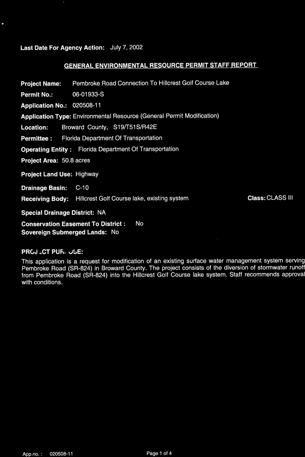
3 TABLE OF CONTENTS 1. Site Description 2. Existing Conditions 3. Post Development 4. Drainage Summary Figures 1. Water Table map Average Wet Season 2. FEMA Flood Zone and 100 Year Flood Elevations Map 3. Existing Aerial 4. Proposed Stormwater Pond Exhibit Appendix A. Post-Development Drainage Calculations B. FDOT Discharge Permit S C. Existing FDOT Easement
4 1. Site Description Hillcrest Residential Development Hollywood, FL DRAINAGE SUMMARY This proposed residential development is located the northwest corner of Pembroke Rd. (SR824) and S Park Road in the City of Hollywood, Florida. This site consists of the existing Hillcrest Country Club 18-hole golf course on the south side of Hillcrest Drive and a former 9-hole golf course on the north side of Hillcrest Drive. The proposed site is +/ Acres consisting of 645 units (single family and multifamily) and associated amenities. As a part of the onsite proposed improvements, all existing buildings and infrastructure will be demolished. 2. Existing Conditions The existing site is two former Golf Courses with associated clubhouses and auxiliary buildings. The majority of the site is relatively flat with a pervious surface. The existing drainage for the Hillcrest Golf Course consists of several wet ponds, with all stormwater runoff currently being retained on site. There is no permitted discharge from the existing site according to the latest South Florida Water Management Permit. There are two existing on-site wet ponds that are currently being used as stormwater treatment ponds for the Pembroke Road ROW drainage system by FDOT. We have included a copy of the Permit and Easement agreement in the Appendix of this summary. There are also two existing on-site wet ponds that are being used to retain reuse water for irrigation which is pumped into the ponds by the City of Hollywood that service the golf course. The FDOT right of way discharges along Pembroke Rd. into two ponds along the south side of the 18-hole golf course via a 60 pipe. The water diverted to the golf course stages up, until it reaches the elevation of a v-notch diversion weir, at which point water begins to discharge downstream into the remainder of the Pembroke Rd. drainage system. Per the easement recorded between FDOT and the existing property owner, the following capacities and volumes are representative of the existing conditions and must be maintained: Design capacity of 36.8 cubic feet per second (cfs) from the grantee s roadway corridor for State Road 824 (Pembroke Road) during a 25 year, three (3) day storm event, as permitted by South Florida Water Management District (SFMWD) Design volume of 6.8 acre feet in Pond 1, and 12.5 acre feet in Pond 2 from the grantee s roadway corridor for State Road 824 (Pembroke Road) for the require storage volume permitted by SFWMD. Under this easement it states the that the grantor shall not effect a reduction in the storage capacity of the existing ponds until such time as the replacement storage area has been constructed and approved in writing by grantee, which approval shall not be unreasonably withheld.
5 In addition to discharge from FDOT, the site accepts reuse water from the City of Hollywood which is stored in two ponds on site. One of these ponds is located on the portion of the project north of Hillcrest Drive and the other is located south of Hillcrest Drive. These ponds store reuse water which is then used for irrigation on the existing golf course. 3. Post Development Post development conditions have been designed to maintain existing conditions as closely as possible. It is proposed that all stormwater will flow through interconnected storm pipes into to a series of wet and dry ponds located throughout the site. These ponds will serve to provide both the stormwater quality and quantity required for this project. There will be no discharge from the on-site drainage system associated with the proposed design and all of the design storms will be maintained in the proposed onsite ponds. We have not included any storage within the site (outside of the ponds) as a factor of safety. As part of the design, the ponds accepting discharge from the FDOT Pembroke Rd ROW are to be relocated. These ponds are proposed to be wet retention ponds, similar to the predevelopment conditions. The location of the proposed ponds are in similar locations to the existing ponds, and will be connected to the FDOT system through an existing 60 pipe and an interconnecting 18 pipe. All criteria dictated in the recorded easement with FDOT is met in the proposed design. The ponds which currently accept and store reuse water from the City of Hollywood are also to be relocated. They will be combined into one pond located along the eastern half of the 18 hole golf course site south of Hillcrest Drive. This pond will have the same storage volume as the two existing reuse storage ponds. 4. Drainage Summary No Discharge - Post Development Hillcrest Rainfall Post-Development Peak Stage NAVD(ft) Design Element 10 yr-24hr yr-72 hr yr-72 hr 9.55 Min. Finished Floor Elev. BC Flood Map Elev. < or = to Note: Datum in Broward County since previous permit has changed from NGVD 29 to NAVD 88. Per the Broward County website, FEMA has computed the official conversion factor for NGVD 29 to NAVD 88 to be This is reflected in the table above and all calculations.
6 FIGURES
7 US27 SW 154TH AVE I75 N FLAMINGO RD HIATUS RD RED RD S SR7 N SR7 S SR7 N SR7 LYONS RD I95 WATER TABLE MAP - AVERAGE WET SEASON PALMBEACH N USHY 27 N US27 S US27 CON SERVAT ION AR EA Water Table Wet Season NAVD (NGVD) Urban Broward County GLADES PKY Miles (7.0) 3.5 (5.0) I75 ROYAL PALM BLVD WESTON RD SOUTH POST RD SW 184TH AVE SW 172ND AVE BROWARD SW 172ND AVE SW 160TH AVE SW 14TH ST GRIFFIN RD PINES BLVD MIRAMAR PKY NW 136TH AVE 1.5 (3.0) N FLAMINGO RD FLAMINGO RD S FLAMINGO RD N HIATUS RD S HIATUS RD HIATUS RD 2.5 (4.0) HIATUS RD NOB HILL RD CORAL RIDGE DR I595 SAWGRASS EXPY NW 44TH ST N NOB HILL RD SW 45TH ST WILES RD W SAMPLE RD W COMMERCIAL BLVD N PINE ISLAND RD UNIVERSITY DR SOUTHGATE BLVD 4.5 (6.0) CLEARY BLVD S NOB HILL RD NOB HILL RD N PALM AVE SW 101ST AVE N UNIVERSITY DR RIVERSIDE DR W BROWARD BLVD S PINE ISLAND RD S UNIVERSITY DR STIRLING RD TAFT ST SHERIDAN ST JOHNSON ST PEMBROKE RD HOMESTEAD TPKE EXT N DOUGLAS RD 8.5 (10.0) NW 5TH ST W ATLANTIC BLVD KIMBERLY BLVD FLORIDA TPKE W OAKLAND PARK BLVD PETERS RD NOVA DR DAVIE RD SUNSET STRIP ROCK ISLAND RD W MCNAB RD SW 72ND AVE HOLMBERG RD BAILEY RD NW 56TH AVE SW 41ST ST BANKS RD NW 31ST AVE W SUNRISE BLVD SW 40TH AVE 0.5 (2.0) N SR7 N 56TH AVE N 46TH AVE W HILLSBORO BLVD NW 62ND ST NW 19TH ST SW 30TH AVE HOLLYWOOD BLVD WASHINGTON ST S SR7 SW 31ST AVE 9.5 (11.0) SW 27TH AVE N PARK RD NW 21ST AVE W COPANS RD NW 6TH ST NW 9TH AVE DAVIE BLVD SR84 W HALLANDALE BEACH BLVD ANGLERS AVE NW 31ST AVE 3.5 (5.0) 0.5 (2.0) NW 49TH CT 6.5 (8.0) 4.5 (6.0) SW 3RD ST N ANDREWS AVE SW 4TH AVE S PERIMETER RD NW 7TH AVE NE 4TH AVE NE 6TH AVE S FEDERAL HWY SW 10TH ST NE 3RD AVE N FEDERAL HWY N DIXIE HWY NE 62ND ST NE 56TH ST NE 15TH AVE S CYPRESS RD S OCEAN DR N OCEAN DR BAYVIEW DR N ATLANTIC BLVD SE 17TH ST ELLER DR NE 10TH ST NE 45TH ST E DANIA BEACH BLVD DIXIE HWY MIAM I-DA DE C OU NT Y S DIXIE HWY NW 9TH AVE PAL M BE ACH C OU NTY 2.5 (4.0) SE 10TH ST N FEDERAL HWY S FEDERAL HWY N OCEAN BLVD S OCEAN BLVD N OCEAN BLVD AT L ANT IC O CEA N N HILLSBORO MILE MIAMI-DADE Division Name: Planning and Environmental Regulation Department Name: Environmental Protection and Growth Management This map is for conceptual purposes only and should not be used for legal boundary determinations. Elevation converted from NGDV to NAVD using the FEMA approved conversion factor for Broward County of (-) 1.5
 N 46TH AVE LYONS RD SW 31ST AVE NOB HILL RD NW 65TH AVE S SR7 N SR7 S SR7 SW 30TH AVE SW 27TH AVE SW 26TH TER NW 23RD AVE NW 21ST AVE FLORIDA TPKE NW 9TH AVE NW 31ST AVE S POWERLINE RD SW 4TH")
8 7 (8.5) US27 S US27 N US27 SW 184TH AVE SW 154TH AVE I75 SW 136TH AVE N FLAMINGO RD RED RD HIATUS RD UNIVERSITY DR 11 (12.5) RIVERSIDE DR DAVIE RD ROCK ISLAND RD CORAL RIDGE DR N SR7 S SR (14) N 46TH AVE LYONS RD SW 31ST AVE NOB HILL RD NW 65TH AVE S SR7 N SR7 S SR7 SW 30TH AVE SW 27TH AVE SW 26TH TER NW 23RD AVE NW 21ST AVE FLORIDA TPKE NW 9TH AVE NW 31ST AVE S POWERLINE RD SW 4TH AVE S FEDERAL HWY N SR7 NW 9TH AVE N DIXIE HWY N MILITARY TRL NE 3RD AVE FEMA FLOOD ZONES (1997) and 100 YEAR FLOOD ELEVATIONS PALMBEACH N USHY Year Flood Contours NAVD (NGVD) ZONE A ZONE AE ZONE AH ZONE AO ZONE VE ZONE X Miles BROWARD 8.5 (10) NW 120TH WAY 9.5 (11) 9 (10.5) 10.5 (12) 10 (11.5) 9.5 (11) 14.5 (16) SAWGRASS EXPY W SAMPLE RD NW 44TH ST N NOB HILL RD N PINE ISLAND RD CORAL SPRINGS DR SOUTHGATE BLVD 10.5 (12) 8.5 (10) SUNSET STRIP WILES RD 11 (12.5) ROYAL PALM BLVD RAMBLEWOOD DR NW 50TH ST N UNIVERSITY DR 9 (10.5) 12 (13.5) 10 (11.5) SW 81ST AVE W COMMERCIAL BLVD INVERRARY BLVD 15 (16.5) KIMBERLY BLVD 14 (15.5) W MCNAB RD BAILEY RD HOLMBERG RD 8 (9.5) 12.5 (14) 10 (11.5) JOHNSON RD BANKS RD 12 (13.5) 14 (15.5) LYONS RD S 11.5 (13) 8 (9.5) 13 (14.5) W MCNAB RD W OAKLAND PARK BLVD NW 19TH ST W HILLSBORO BLVD NW 48TH ST 8.5 (10) NW 62ND ST 6.5 (8) 13.5 (15) 7.5 (9) W PROSPECT RD 5.5 (7) N POWERLINE RD NW 49TH CT W COPANS RD MARTIN LUTHER KING BLVD W ATLANTIC BLVD N ANDREWS AVE PALM BEACH COUNTY SW 3RD ST 7.5 (9) NE 6TH AVE 6 (7.5) SW 10TH ST N DIXIE HWY NE 62ND ST NE 56TH ST 12.5 (14) 11.5 (13) E COMMERCIAL BLVD WILTON DR NW 48TH ST S CYPRESS RD NE 45TH ST NE 26TH ST N FEDERAL HWY NE 48TH ST 4.5 (6) E SAMPLE RD NE 10TH ST E ATLANTIC BLVD E MCNAB RD BAYVIEW DR E HILLSBORO BLVD S DIXIE HWY NE 23RD ST S FEDERAL HWY SE 10TH ST NE 49TH ST 5 (6.5) N OCEAN BLVD N FEDERAL HWY 4.5 (6) 5.5 (7) NE 14TH ST N OCEAN DR S OCEAN BLVD N OCEAN BLVD HILLSBORO MILE N OCEAN DR 7.5 (9) GLADES PKY I75 SOUTH POST RD INDIAN TRCE 7 (8.5) BONAVENTURE BLVD SADDLE CLUB RD ROYAL PALM BLVD 7.5 (9) 6.5 (8) I (9) 6.5 (8) NW 5TH ST W BROWARD BLVD 8.5 (10) 7.5 (9) 8 (9.5) W SUNRISE BLVD NW 31ST AVE 6.5 (8) SR (7) 6.5 (8) 5.5 (7) GRIFFIN RD WESTON RD SW 36TH ST SW 14TH ST NW 136TH AVE N HIATUS RD S HIATUS RD HIATUS RD S NOB HILL RD CLEARY BLVD S PINE ISLAND RD SW 30TH ST NOVA DR COLLEGE AVE PETERS RD NW 6TH ST DAVIE BLVD S ANDREWS AVE S FEDERAL HWY SE 17TH ST 6.5 (8) NOB HILL RD SW 45TH ST 6 (7.5) STIRLING RD S UNIVERSITY DR 6 (7.5) 5.5 (7) N PARK RD 6.5 (8) 6.5 (8) PINES BLVD SW 172ND AVE SHERIDAN ST SW 160TH AVE 6.1 (7.6) S FLAMINGO RD NW 56TH AVE RIVERLAND RD NW 27TH AVE RAVENSWOOD RD NW 7TH AVE SW 34TH ST NE 4TH AVE NE 13TH ST E BROWARD BLVD E LAS OLAS BLVD SE 24TH ST E PERIMETER RD ELLER DR NE 20TH AVE N ATLANTIC BLVD SEABREEZE BLVD ATLANTIC OCEAN SW 100TH AVE SW 40TH AVE SW 42ND ST ANGLERS AVE S PERIMETER RD N FEDERAL HWY E DANIA BEACH BLVD CONSERVATION AREA NW 184TH AVE NW 172ND AVE NW 160TH AVE N FLAMINGO RD N HIATUS RD HIATUS RD 6 (7.5) N PALM AVE N DOUGLAS RD DAVIE ROAD EXT TAFT ST JOHNSON ST N 72ND AVE 7.5 (9) 8.5 (10) N 56TH AVE HOLLYWOOD BLVD I95 DIXIE HWY N DIXIE HWY S DIXIE HWY S FEDERAL HWY N FEDERAL HWY SHERIDAN ST 5.5 (7) HOLLYWOOD BLVD N OCEAN DR S FLAMINGO RD SW 72ND AVE S 62ND AVE WASHINGTON ST SW 172ND AVE MIRAMAR PKY SW 160TH AVE S HIATUS RD FLAMINGO RD HIATUS RD 6.5 (8) PEMBROKE RD SW 101ST AVE S UNIVERSITY DR S DOUGLAS RD HOMESTEAD TPKE EXT SW 41ST ST SW 62ND AVE 8.5 (10) SW 56TH AVE S PARK RD W HALLANDALE BEACH BLVD MIAMI-DADE COUNTY S DIXIE HWY 5 (6.5) S OCEAN DR N 5.8 (7.3) MIAMI-DADE Division Name: Planning and Environmental Regulation Department Name: Environmental Protection and Growth Management This map is for conceptual purposes only and should not be used for legal boundary determinations. Elevation converted from NGDV to NAVD using the FEMA approved conversion factor for Broward County of (-) 1.5


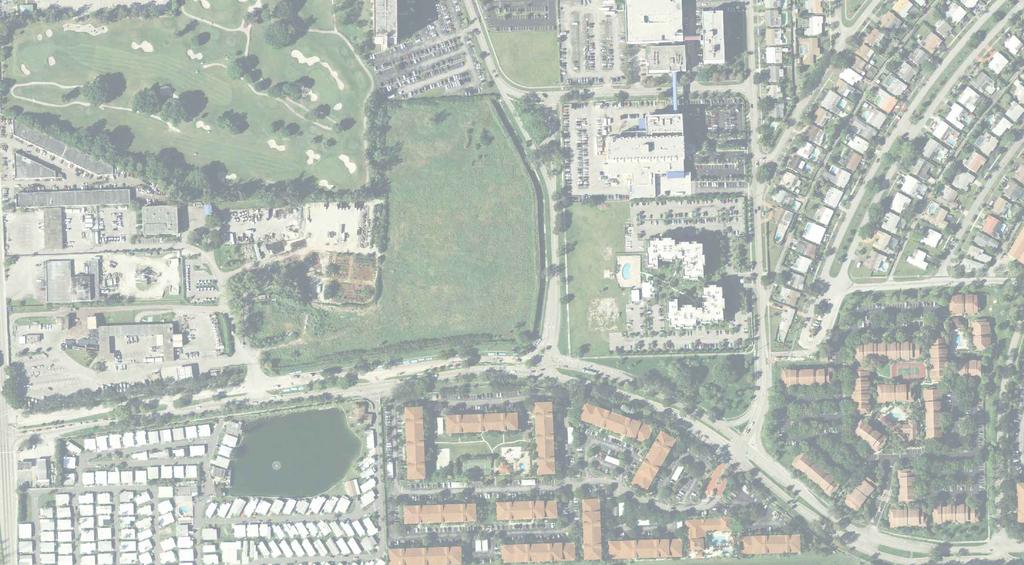
9 Exist. Re-Use Pond Exist. FDOT Pond HILLCREST RESIDENTIAL DEVELOPMENT AERIAL LOCATION MAP EX
10
11 APPENDIX A POST-DEVELOPMENT DRAINAGE CALCULATIONS
12 Post-Development Curve Number TR-55 Methodology - Post Conditions CURVE NUMBER HILL CREST Description Area (SF) Area (AC) % of Total Impervious Pavement 787, % Building & Driveways 1,416, % Sidewalk/Trail 249, % Site Water Surface % Impervious Total = 2,452, Pervious Group (D) 3,356, % HILL CREST Description Area (SF) Area (AC) % of Total Impervious Road % Building % Sidewalk % Driveway/Garage 0.0 Pond Water Surface 558, % Impervious Total = 558, Pervious Group (D) 485, % Total Area* = 6,853, % *Total Area is Site Excluding FDOT and Re-Use Ponds Total Pavement = 1,036, % Total Building = 1,416, % Total Pervious = 3,842, % Total Wet Pond = 558, % Total Project Area = 6,853, % *Total Area is Site Excluding FDOT and Re-Use Ponds SOIL STORAGE: AVG. DEPTH TO WATER TABLE = AVG. PROPOSED GRADE - WATER LEVEL AVG GRADE WATER LEVEL D=(FT) SOIL STORAGE (S) = AVAILABLE SOIL STORAGE X PERVIOUS AREA/TOTAL AREA SEE C-35, SFWMD VOL.IV) AVG. SOIL ST. PERVIOUS (AC) TOTAL (AC) (S) = (IN) CN = 1000/(S+10) 68.56
13 Post-Development Runoff Volume Calculator Based on the Soil Conservation Service Technical Release 55 Urban Hydrology for Small Watersheds, June 1986 Project Name: HILLCREST Project Number: Calculated By: Aaron Struckmeyer Calculated Date: 8/18/2015 [Eq. 2-4] S = CN [Eq. 2-3] Q = (P 0.2S) 2 (P + 0.8S) 10 Year 24 Hour INPUT: P = Rainfall Depth: 9.20 inches CN = Curve Number: A = Basin Area: acres S = Potential Maximum Retention After Runoff 4.59 Begins: Q = Runoff: 5.33 inches = 0.44 feet OUTPUT:. V = Runoff Volume: acre-feet INPUT: OUTPUT: INPUT: OUTPUT: 25 Year 72 Hour P = Rainfall Depth: inches CN = Curve Number: A = Basin Area: acres S = Potential Maximum Retention After Runoff Begins: 4.59 Q = Runoff: 9.22 inches = 0.77 feet V = Runoff Volume: acre-feet 100 Year 72 Hour P = Rainfall Depth: inches CN = Curve Number: A = Basin Area: acres S = Potential Maximum Retention After Runoff 4.59 Begins: Q = Runoff: inches = 1.04 feet V = Runoff Volume: acre-feet
14 Post Development Site Storage Volume Date: 8/18/2015 By: AAS ALL ELEVATIONS LISTED IN NAVD '88 SITE PONDS UNDERGROUND TOTAL ONSITE Note: assume linear site storage between low and high elevation and vertical storage above high elev. Min. Elevation = 0.5 Control Elevation = 0.5 Control Elevation = 0.5 Control Elevation = 0.5 Finished Floor Elevation = 11 Finished Floor Elevation = 11 Finished Floor Elevation = 11 Finished Floor Elevation 11 Area at Control Elevation = 0 Area at Control Elevation = Area at Control Elevation Area at Top of Bank = Area at Top of Bank = PIPE VOLUME 0.00 ac-ft Area at Top of Bank = Building Area = Building Area = 0.00 Building Area = 0 PIPE VOLUME Area at Control Elevation Additional Site Area at Top of Bank Total Total Total Total Area at Control Elevation Additional Site Area at Top of Bank Total Total Total Total Sub-Area Sub-Area Sub-Area Sub-Area Low El Site Site Site Low El Site Site Site Low El. Low El. Site Total Total Total Total High El Storage Storage Storage Storage High El Storage Storage Storage Storage High El. Storage High El. Storage Storage Storage Area (ft^2) Area (ft^2) Area (ft^2) Area (ft^2) NO UNDERGROUND WITH UNDERGROUND Area (acres) Area (acres) Area (acres) Area (acres) Stage Linear Vert. Linear Vert. Stage Stage Linear Vert. Linear Vert. Stage Stage Stage NAVD Stor. Stor. Stor. Stor. NAVD (ac-ft) (ac) (ac) (ac) (NGVD) Stor. Stor. Stor. Stor. NAVD (ac-ft) (ac) (ac) (ac) (NGVD) (ac-ft) (NGVD) (ac) (ac-ft) (ac-ft) #DIV/0! #DIV/0! #DIV/0! #DIV/0! 10 Year 24 Hour 25 Year 72 Hour 100 Year 72 Hour
15 APPENDIX B FDOT Discharge Permit S
16

17

18
19
20
21
22
23
24
25
26


27

28
29
30


31
32
33
34
35
36

37
38
39 APPENDIX C Existing Perpetual Easement between Hillcrest Country Club, Limited Partnership and the State of Florida Department of Transportation
40
41
42
43
44
45
46
WATER MANAGEMENT REPORT FOR PAGE ESTATES
 WATER MANAGEMENT REPORT FOR PAGE ESTATES SLB Consulting of SW Florida, LLC PO Box 2826 Bonita Springs, FL. 34133 Phone: 239-948-9566 sandra@slbconsult.com C.O.A. # 25395 September 1, 2014 Sandra L. Bottcher
DRAINAGE CALCULATIONS
 DRAINAGE CALCULATIONS NW 8 th Street and NW 8 th Terrace Roadway and Drainage Improvements City of Miami Project B-30745 And NW 14 th Court Roadway and Drainage Improvements City of Miami Project B-30746
LOCATED IN INDIAN RIVER COUNTY PREPARED FOR S.J.R.W.M.D. AND F.W.C.D. DECEMBER, 2003 Updated 2007 Updated May 2014 PREPARED BY
 FELLSMERE WATER CONTROL DISTRICT EAST MASTER DRAINAGE PLAN AND STORMWATER HYDROLOGIC ANALYSIS OF THE GRAVITY DRAINAGE SYSTEM LOCATED BETWEEN THE EAST BOUNDARY, LATERAL U, THE MAIN CANAL, AND DITCH 24 LOCATED
BRANDON LAKES AVENUE PRE AND POST CONDITIONS DRAINAGE REPORT
 BRANDON LAKES AVENUE PRE AND POST CONDITIONS DRAINAGE REPORT Hillsborough County Public Works County Center, 22nd Floor 601 E. Kennedy Blvd. Tampa, FL 33602 BRANDON LAKES AVENUE DRAINAGE IMPROVEMENTS Capital
INFLOW DESIGN FLOOD CONTROL SYSTEM PLAN 40 C.F.R. PART PLANT YATES ASH POND 2 (AP-2) GEORGIA POWER COMPANY
 GEORGIA POWER COMPANY") INFLOW DESIGN FLOOD CONTROL SYSTEM PLAN 40 C.F.R. PART 257.82 PLANT YATES ASH POND 2 (AP-2) GEORGIA POWER COMPANY EPA s Disposal of Coal Combustion Residuals from Electric Utilities Final Rule (40 C.F.R.
INFLOW DESIGN FLOOD CONTROL SYSTEM PLAN 40 C.F.R. PART 257.82 PLANT YATES ASH POND 2 (AP-2) GEORGIA POWER COMPANY EPA s Disposal of Coal Combustion Residuals from Electric Utilities Final Rule (40 C.F.R.
Stormwater Guidelines and Case Studies. CAHILL ASSOCIATES Environmental Consultants West Chester, PA (610)
") Stormwater Guidelines and Case Studies CAHILL ASSOCIATES Environmental Consultants West Chester, PA (610) 696-4150 www.thcahill.com Goals and Challenges for Manual State Stormwater Policy More Widespread
Stormwater Guidelines and Case Studies CAHILL ASSOCIATES Environmental Consultants West Chester, PA (610) 696-4150 www.thcahill.com Goals and Challenges for Manual State Stormwater Policy More Widespread
FOR LEASE ±1,800 SF OUTPARCEL NEW CONSTRUCTION, SINGLE TENANT
 FOR LEASE ±1,800 SF OUTPARCEL NEW CONSTRUCTION, SINGLE TENANT DEERFIELD BEACH FL 33441 ROXANNE REGISTER Vice President of Leasing & Sales RoxanneRegister@dkatz.com (561) 869-4346 HIGHLIGHTS Retail only
Section 4: Model Development and Application
 Section 4: Model Development and Application The hydrologic model for the Wissahickon Act 167 study was built using GIS layers of land use, hydrologic soil groups, terrain and orthophotography. Within
STREUVER FIDELCO CAPPELLI, LLC YONKERS DOWNTOWN DEVELOPMENT PHASE 1. DRAFT ENVIRONMENTAL IMPACT STATEMENT For: PALISADES POINT
 STREUVER FIDELCO CAPPELLI, LLC YONKERS DOWNTOWN DEVELOPMENT PHASE 1 DRAFT ENVIRONMENTAL IMPACT STATEMENT For: PALISADES POINT Prepared by: PAULUS, SOKOLOWSKI & SARTOR STORMWATER MANAGEMENT 1. Methodology
Continuing Education Course #101 Drainage Design with WinTR-55
 1 of 5 Continuing Education Course #101 Drainage Design with WinTR-55 1. WinTR-55 uses the Kinematic Wave method for calculating storm runoff rates and volumes. 2. According to the Velocity Method, the
ARTICLE 5 (PART 2) DETENTION VOLUME EXAMPLE PROBLEMS
 DETENTION VOLUME EXAMPLE PROBLEMS") ARTICLE 5 (PART 2) DETENTION VOLUME EXAMPLE PROBLEMS Example 5.7 Simple (Detention Nomograph) Example 5.8 Offsite and Unrestricted Areas (HEC-HMS) Example 5.9 Ponds in Series w/ Tailwater (HEC-HMS) Example
ARTICLE 5 (PART 2) DETENTION VOLUME EXAMPLE PROBLEMS Example 5.7 Simple (Detention Nomograph) Example 5.8 Offsite and Unrestricted Areas (HEC-HMS) Example 5.9 Ponds in Series w/ Tailwater (HEC-HMS) Example
STORMWATER MANAGEMENT COMPUTATIONS. Mount Prospect
 STORMWATER MANAGEMENT COMPUTATIONS Mount Prospect MHG PROJECT No. 2011.173.11 November 6, 2014 Prepared for: Piney Meetinghouse Investments c/o Mr. Dennis Fling 14801 Clopper Road Boyds, MD 20841 (301)
STORMWATER REPORT FRITO LAY SUBDIVISION NO. 3
 STORMWATER REPORT FRITO LAY SUBDIVISION NO. 3 May 2018 STORMWATER REPORT I. Subdivision Data a. The parcel is adjacent to the existing Frito Lay property in Topeka; and the subject plat application encompasses
CITY OF CAPE CORAL STORMWATER MASTER PLAN PHASE II - PART 1 BASINS 4, 10, & 14 SUB-BASIN DRAINAGE IMPROVEMENTS HYDRAULIC ANALYSIS SUMMARY
 CITY OF CAPE CORAL STORMWATER MASTER PLAN PHASE II - PART 1 BASINS 4, 10, & 14 SUB-BASIN DRAINAGE IMPROVEMENTS HYDRAULIC ANALYSIS SUMMARY Cape Coral, FL Prepared for: The City of Cape Coral Public Works
FUND THAN THAN ALL CODE YEARS
 PAGE 1 FLORIDA DEPARTMENT OF TRANSPORTATION DATE RUN: 07/20/2012 HIGHWAYS ITEM NUMBER:230724 1 PROJECT DESCRIPTION:ANDREWS AVE EXT FROM POMPANO PARK PLACE TO S. OF ATLANTIC BLVD *NON-SIS* DISTRICT:04 COUNTY:BROWARD
2012 Hurricane Preparedness Guide
 2012 Hurricane Preparedness Guide IMPORTANT TELEPHONE NUMBERS: Emergency 911 Hollywood Emergency Operations Center 954.967.4EOC(4362) Hollywood Police Department non-emergency 954.967.HELP (4357) Hollywood
Submitted to: St. Johns River Power Park New Berlin Road Jacksonville, FL 32226
 RUN-ON/RUN-OFF CONTROL SYSTEM PLAN RUN-ON AND RUN-OFF CONTROL SYSTEM PLAN St. Johns River Power Park Byproduct Storage Area B Phase I Development Submitted to: St. Johns River Power Park 11201 New Berlin
Monitoring Considerations and Costs
 Monitoring Considerations and Costs Stormwater BMP Selection, Design, and Monitoring Florida Stormwater Association September 9, 2016 Harvey H. Harper, Ph.D., P.E. Environmental Research & Design, Inc.
EROSION CONTROL NARRATIVE
 EROSION CONTROL NARRATIVE Erosion and sediment control has been designed for the Willow Bend Phase I Subdivision according to UDFCD and the City of Thornton criteria, in order to minimize erosion and sediment
Wal-mart Store # Ft. Walton Beach, FL NE Corner of Eglin Parkway/S.R. 85 and South Street STORMWATER REPORT. February 2017
 Wal-mart Store #6746-00 Ft. Walton Beach, FL NE Corner of Eglin Parkway/S.R. 85 and South Street STORMWATER REPORT February 2017 CPH Project No. W13900 1031-C W. 23rd Street Panama City, FL 32405 Phone
Hydrology and Hydraulics Design Report. Background Summary
 To: National Park Services Montezuma Castle National Monument Richard Goepfrich, Facility Manager From: Multicultural Technical Engineers Date: Tuesday - February 13, 2018 Subject: 30% Hydrology and Hydraulics
DRAINAGE REPORT FOR THORNTON SELF STORAGE THORNTON, COLORADO
 DRAINAGE REPORT FOR THORNTON SELF STORAGE THORNTON, COLORADO Prepared by: Bowman Consulting 603 Park Point Dr. Suite 100 Golden, CO 80401 (303)-801-2900 June 29, 2015 Revised August 14, 2015 CERTIFICATE
Water Management and Hydrology of Northeast Shark River Slough from 1940 to 2015
 Water Management and Hydrology of Northeast Shark River Slough from 1940 to 2015 Greater Everglades Ecosystem Restoration Conference April 2015 Kevin Kotun, Hydrologist Physical Resources Branch South
Chapter 5 CALIBRATION AND VERIFICATION
 Chapter 5 CALIBRATION AND VERIFICATION This chapter contains the calibration procedure and data used for the LSC existing conditions model. The goal of the calibration effort was to develop a hydraulic
PENNSYLVANIA DEPARTMENT OF TRANSPORTATION ENGINEERING DISTRICT 3-0
 PENNSYLVANIA DEPARTMENT OF TRANSPORTATION ENGINEERING DISTRICT 3-0 LYCOMING COUNTY S.R.15, SECTION C41 FINAL HYDROLOGIC AND HYDRAULIC REPORT STEAM VALLEY RUN STREAM RELOCATION DATE: June, 2006 REVISED:
City of Thornton Attn: Tim Semones Development Engineeering 9500 Civic Center Dr. Thornton, CO 80229
 Development Engineering Land Surveying Construction Administration District Services October 20, 2017 City of Thornton Attn: Tim Semones Development Engineeering 9500 Civic Center Dr. Thornton, CO 80229
September 6, City of Thornton 9500 Civic Center Drive Thornton, CO (303) RE: Maverik Thornton, CO - Drainage Report
 RE: Maverik Thornton, CO - Drainage Report") September 6, 2016 City of Thornton 9500 Civic Center Drive Thornton, CO 80229 (303) 538-7295 RE: Maverik Thornton, CO - Drainage Report As per your request, we are submitting to you the drainage report
September 6, 2016 City of Thornton 9500 Civic Center Drive Thornton, CO 80229 (303) 538-7295 RE: Maverik Thornton, CO - Drainage Report As per your request, we are submitting to you the drainage report
HISTORY OF CONSTRUCTION FOR EXISTING CCR SURFACE IMPOUNDMENT PLANT GASTON ASH POND 40 CFR (c)(1)(i) (xii)
(1)(i) (xii)") HISTORY OF CONSTRUCTION FOR EXISTING CCR SURFACE IMPOUNDMENT PLANT GASTON ASH POND 40 CFR 257.73(c)(1)(i) (xii) (i) Site Name and Ownership Information: Site Name: E.C. Gaston Steam Plant Site Location:
HISTORY OF CONSTRUCTION FOR EXISTING CCR SURFACE IMPOUNDMENT PLANT GASTON ASH POND 40 CFR 257.73(c)(1)(i) (xii) (i) Site Name and Ownership Information: Site Name: E.C. Gaston Steam Plant Site Location:
APPENDIX B DRAINAGE REPORT
 APPENDIX B DRAINAGE REPORT B-1 South Lamar Blvd. Transportation Corridor Study Drainage Report Prepared for: City of Austin and HDR, Inc. Prepared by: and Services, Inc. Final 07-09-2015 Michael C. Meriwether,
Stormwater Capacity Analysis for Westover Branch Watershed
 Stormwater Capacity Analysis for Westover Branch Watershed Pimmit Run Little Pimmit Run, Mainstem Stohman's Run Gulf Branch Pimmit Run Tributary Little Pimmit Run, W. Branch Little Pimmit Run, E. Branch
THE NEED FOR AN ADDITIONAL SPILLWAY AT THE SANFORD DAM BOILING SPRING LAKES, NC. Presentation for The Brunswick County Commissioners April 20, 2015
 THE NEED FOR AN ADDITIONAL SPILLWAY AT THE SANFORD DAM BOILING SPRING LAKES, NC Presentation for The Brunswick County Commissioners April 20, 2015 The Sanford Dam Earth Dam constructed in 1961 Drainage
Technical Memorandum. City of Salem, Stormwater Management Design Standards. Project No:
 Technical Memorandum 6500 SW Macadam Avenue, Suite 200 Portland, Oregon, 97239 Tel: 503-244-7005 Fax: 503-244-9095 Prepared for: Project Title: City of Salem, Oregon City of Salem, Stormwater Management
CIVIL CONSULTING ENGINEERS
 CIVIL CONSULTING ENGINEERS Table of Contents Table of Contents 1. Narrative... 4 2. Site Conditions... 4 2.1. Existing Conditions... 4 2.2. Proposed Conditions... 4 3. Land Use Summary... 5 3.1. Pre-Development
A HYDROLOGIC STUDY OF THE EFFECTS OF URBAN DEVELOPMENT ON STORM RUNOFF: A CASE STUDY IN QUEENS, NY ABSTRACT
 154 A HYDROLOGC STUDY OF THE EFFECTS OF URBAN DEVELOPMENT ON STORM RUNOFF: A CASE STUDY N QUEENS, NY Monica Tsang-Rakovan, Kevin J. Phillips, Khalid Bajwa, John Ferrelli, Fanning, Phillips and Molnar Fanning,
City of Columbia BMP Manual. Detailed Unified Sizing Criteria Example Wet Pond Design
 City of Columbia BMP Manual Detailed Unified Sizing Criteria Example Wet Pond Design April 17, 2013 Wet Pond Example: Unified Sizing Criteria Methodology Base Data Location: Rome, GA Site Drainage Area
Project Description. Project Options. End Analysis On... Apr 26, :00:00. Rainfall Details
 Project Description File Name... 323 - Att Pond 3 East PIPES ONLY.SPF Project Options Flow Units... Elevation Type... Hydrology Method... EPA SWMM Infiltration Method... Link Routing Method... Enable Overflow
UTILITY REPORT FOR THORNTON SELF STORAGE THORNTON, COLORADO
 UTILITY REPORT FOR THORNTON SELF STORAGE THORNTON, COLORADO Prepared by: Bowman Consulting 63 Park Point Dr. Suite 1 Golden, CO 841 (33)-81-29 June 29, 215 Revised August 14, 215 Revised September 3, 215
The following maps must be provided as a part of the ADA. The appropriate scale for each map should be determined at the pre application conference.
 Main Street @ Coconut Creek DRI QUESTION 9 MAPS The following maps must be provided as a part of the ADA. The appropriate scale for each map should be determined at the pre application conference. Map
sea levels 100 year/ payments. FIGURE 1
 MIAMI DADE COUNTY CLIMATE INDICATORS RAINFALL SUMMARY Much of Miami Dade County is susceptible to localized flooding, particularly during the rainy season of June through October. The County s flat terrain
UPPER COSUMNES RIVER FLOOD MAPPING
 UPPER COSUMNES RIVER FLOOD MAPPING DRAFT BASIC DATA NARRATIVE FLOOD INSURANCE STUDY SACRAMENTO COUTY, CALIFORNIA Community No. 060262 November 2008 Prepared By: CIVIL ENGINEERING SOLUTIONS, INC. 1325 Howe
Hydrology Study Report
 Hafeez Consulting www.hafeezconsulting.com Civil/ Structural Engineering, Design & Construction 1451 S. Hacienda St. Anaheim CA 92804 (714) 225-4565 Fax (714)917-2977 engineer@hafeezconsulting.com Hydrology
 Red River Flooding June 2015 Caddo and Bossier Parishes Presented by: Flood Technical Committee Where the Rain Falls Matters I-30 versus I-20 I-20 Backwater and Tributary Floods (Localized) 2016 Flood
Randall W. Parkinson, Ph.D., P.G. Institute of Water and Environment Florida International University
 An Update on Adaptation Action Activities Undertaken Since Completion of the City of Satellite Beach (FL) Vulnerability Assessment to Rising Seas (2010) Randall W. Parkinson, Ph.D., P.G. Institute of Water
Drainage Analysis. Appendix F
 Drainage Analysis Appendix F Golden View Drive Elizabeth Street LMORE CREEK Ricky Road Rabbit Creek Road LITTLE RABBIT CREEK East 156th Avenue MOA Project #10-026 Golden View Drive Intersection
Red River Levee Panel
 Red River Levee Panel Mississippi River Commission Monday, August 9, 2017 Red River Levees in LA & AR NONE along TX & OK Boarder Red River Levee Issues Caddo Levee Cherokee Park Authorization Bossier Levee
Seagrass Transplantation & Environmental & Marine Consulting Services, Inc. Drew Campbell, Vice President & Lead Scientst.
 Indian River Lagoon Symposium Seagrass Transplantation & Project Considerations Environmental & Marine Consulting Services, Inc. Drew Campbell, Vice President & Lead Scientst March 26 th, 2013 Regulatory
Final Drainage Report
 Final Drainage Report Expo Rail Operations and Maintenance Facility Santa Monica, California Prepared for: Exposition Metro Line Construction Authority Prepared by: W2 Design, Inc. 50 S. De Lacey Avenue
MIAMI-SOUTH FLORIDA National Weather Service Forecast Office
 MIAMI-SOUTH FLORIDA National Weather Service Forecast Office http://www.weather.gov/miami June 2015 South Florida Weather Summary Dry East, Wet West...Drought Remains SE Florida July 3, 2015: Depending
Rock & Aggregate Drop Inlet Protection
 Rock & Aggregate Drop Inlet Protection SEDIMENT CONTROL TECHNIQUE Type 1 System Sheet Flow Sandy Soils Type 2 System [1] Concentrated Flow Clayey Soils Type 3 System Supplementary Trap Dispersive Soils
Pequabuck River Flooding Study and Flood Mitigation Plan The City of Bristol and Towns of Plainville and Plymouth, CT
 Pequabuck River Flooding Study and Flood Mitigation Plan The City of Bristol and Towns of Plainville and Plymouth, CT Raymond Rogozinski and Maged Aboelata The City of Bristol and Towns of Plainville and
Elementary School 1,488 1,488
 Facility Planning and Real Estate Department Facility Planning Florida Inventory of School Houses (F.I.S.H.)* Capacity Update Report Facility Name Elementary School Permanent Capacity 1 Relocatable Capacity
Appendix E Guidance for Shallow Flooding Analyses and Mapping
 Appendix E Guidance for Shallow Flooding Analyses and Mapping E.1 Introduction Different types of shallow flooding commonly occur throughout the United States. Types of flows that result in shallow flooding
73-2 have been satisfied; and
 RESOLUTION NO. R- 86-104 W'dEREAS, the Board of County Commissioners, as the governing body, pursuant to the authority vested in Chapter 163 and Chapter 125, Florida Statutes, is authorized and empowered
Between 6 am to 4 pm the next day approximately 7.5 inches fell. Chesapeake Bay Bridge Tunnel NOAA Tide Gage
 Ocean Park Alternative Drainage Route Analysis February, 2012 November 11 14, 2009 Between 6 am to 4 pm the next day approximately 7.5 inches fell Chesapeake Bay Bridge Tunnel NOAA Tide Gage Hurricane
Chapter 7 Mudflow Analysis
 Chapter 7 Mudflow Analysis 7.0 Introduction This chapter provides information on the potential and magnitude of mud floods and mudflows that may develop in Aspen due to rainfall events, snowmelt, or rain
Local Flood Hazards. Click here for Real-time River Information
 Local Flood Hazards Floods of the White River and Killbuck Creek are caused by runoff from general, and/or intense rainfall. Other areas of flooding concern are from the Boland Ditch and Pittsford Ditch.
DUCK POND WATERSHED MANAGEMENT PLAN UPDATE APPENDICES. Prepared for:
 DUCK POND WATERSHED MANAGEMENT PLAN UPDATE APPENDICES Prepared for: Stormwater Management Section Public Works Department, Hillsborough County 60 E. Kennedy Blvd Tampa, FL 33602 Engineers/Planners/Scientists
Stormwater Drainage Design Report. Reeve & Associates, Inc. Maverik, Inc. 88th Avenue and Pecos Street. Thornton, CO
 88th Avenue and Pecos Street Stormwater Drainage Design Report Reeve & Associates, Inc. Solutions You Can Build On for Maverik, Inc. 88th Avenue and Pecos Street Thornton, CO submitted to Reeve & Associates,
Table 1. August average temperatures and departures from normal ( F) for selected cities.
 for selected cities.") Climate Summary for Florida August 2016 Prepared by Lydia Stefanova and David Zierden Florida Climate Center, The Florida State University, Tallahassee, Florida Online at: http://climatecenter.fsu.edu/products-services/summaries
Climate Summary for Florida August 2016 Prepared by Lydia Stefanova and David Zierden Florida Climate Center, The Florida State University, Tallahassee, Florida Online at: http://climatecenter.fsu.edu/products-services/summaries
This site will utilize an infiltration berm to manage the two-year/24-hour volume increase.
 Gates TETRA TECH, INC. By: RH Date: 11/11/2016 Subject: Gates Road Checked By: JB Date: 11/13/2016 PCSM Design and Evaluation PURPOSE: The purpose of these calculations is to design a Post-Construction
Sea level rise Web GIS Applications
 Florida International University FIU Digital Commons GIS Center GIS Center 2018 Sea level rise Web GIS Applications Zhaohui Fu GIS-RS Center, Florida International University, Fujen@fiu.edu Sheyla Santana
FOR PROJECTS INITIATED AFTER NOVEMBER 1, 2008 ITEM 716 EMBANKMENT EARTH OUTLET SEDIMENT TRAP
 AFTER NOVEMBER 1, 2008 ITEM 716 EMBANKMENT EARTH OUTLET SEDIMENT TRAP 716.1 Description. This work shall consist of furnishing, installing, maintaining, and removing temporary erosion protection and sediment
Chapter 7 Mudflow Analysis
 Chapter 7 Mudflow Analysis 7.0 Introduction This chapter provides information on the potential and magnitude of mud floods and mudflows that may develop in Aspen due to rainfall events, snowmelt, or rain
Assessment of Catch Basin Inserts
 WATERSHED PROTECTION DIVISION DEPARTMENT OF PUBLIC WORKS BUREAU OF SANITATION CITY OF LOS ANGELES Technical Report: Assessment of Catch Basin Inserts JUNE 2006 REVISED 02/21/07 WATERSHED PROTECTION DIVISION
STRUCTURAL STABILITY ASSESSMENT
 STRUCTURAL STABILITY ASSESSMENT CFR 257.73(d) Bottom Ash Pond Complex Cardinal Plant Brilliant, Ohio October, 2016 Prepared for: Cardinal Operating Company Cardinal Plant Brilliant, Ohio Prepared by: Geotechnical
TREASURE COAST REGIONAL PLANNING COUNCIL M E M O R A N D U M. To: Council Members AGENDA ITEM 4B10
 TREASURE COAST REGIONAL PLANNING COUNCIL M E M O R A N D U M To: Council Members AGENDA ITEM 4B10 From: Date: Subject: Staff December 14, 2018 Council Meeting Local Government Comprehensive Plan Review
SPRINGVILLE CITY, UTAH PRESSURE IRRIGATION SYSTEM DRAFT. MASTER PLAN & CAPITAL FACILITIES PLAN For the WEST FIELDS. February 11, 2014.
 SPRINGVILLE CITY, UTAH PRESSURE IRRIGATION SYSTEM MASTER PLAN & CAPITAL FACILITIES PLAN For the WEST FIELDS February 11, 2014 Prepared by: J-U-B ENGINEERS, INC. 240 West Center Street, Suite 200 Orem,
SPRINGVILLE CITY, UTAH
 SPRINGVILLE CITY, UTAH PRESSURE IRRIGATION SYSTEM MASTER PLAN & CAPITAL FACILITIES PLAN For the WEST FIELDS February 11, 2014 Adopted May 20, 2014 Prepared by: J-U-B ENGINEERS, INC. 240 West Center Street,
THE SCHOOL BOARD OF BROWARD COUNTY, FLORIDA OFFICE OF THE SUPERINTENDENT ROBERT W. RUNCIE SUPERINTENDENT OF SCHOOLS
 THE SCHOOL BOARD OF BROWARD COUNTY, FLORIDA OFFICE OF THE SUPERINTENDENT ROBERT W. RUNCIE SUPERINTENDENT OF SCHOOLS August 15, 2018 Signatures on file TO: FROM: VIA: SUBJECT: School Board Members Leslie
CASE STUDIES. Introduction
 Introduction The City of Winston-Salem faces the challenge of maintaining public infrastructure (e.g., water and sewer lines, storm drains, roads, culverts and bridges) while minimizing the potential impacts
APPENDIX E. Photographs of Hazard Events in Broome County. DMA 2000 Hazard Mitigation Plan Broome County, New York E-1
 APPENDIX E Photographs of Hazard Events in Broome County DMA 2000 Hazard Mitigation Plan Broome County, New York E-1 Flood of June 2006 (FEMA DR 1650) Sources: Binghamton NWS Forecast Office / Press and
TPDES: Soil, Erosion and Sedimentation Methods
 SAWS TPDES: Soil, Erosion and Sedimentation Methods Philip Handley Supervisor-Resource Protection & Compliance August 25, 2014 TPDES: Soil, Erosion and Sedimentation Methods Soil Common term: Dirt Common
HYDROLOGY REPORT Tentative Tract No. 5978
 ATTACHMENT 5 October 2016 HYDROLOGY REPORT Tentative Tract No. 5978 City of Simi Valley County of Ventura Prepared For: Landsea Holdings Corporation 7525 Irvine Center Drive Suite 200 Irvine, CA 92618
Rainfall Estimation at S-44 Site
 Technical Note EMA # 389 Rainfall Estimation at S-44 Site (January 2 "d, 3 rd, and 1 7 th, 1999 Events) March 1999 by Alaa Ali & Wossenu Abtew Hydro Information Systems and Assessment Department Environmental
Chapter 10 - Sacramento Method Examples
 Chapter 10 Sacramento Method Examples Introduction Overview This chapter presents two example problems to demonstrate the use of the Sacramento method. These example problems use the SACPRE and HEC-1 computer
Rucker Pond. Background
 Rucker Pond Background The Rucker Basin consists of two subbasins (East and West) that drain to a single area known as Rucker Pond. Both subbasins have the same hydraulic parameters, but have different
Sediment Trap. At multiple locations within the project site where sediment control is needed.
 Sediment Trap SE-3 Objectives EC Erosion Control SE Sediment Control TR Tracking Control WE Wind Erosion Control Non-Stormwater NS Management Control Waste Management and WM Materials Pollution Control
Technical Memorandum #2 Future Conditions
 Technical Memorandum #2 Future Conditions To: Dan Farnsworth Transportation Planner Fargo-Moorhead Metro Council of Governments From: Rick Gunderson, PE Josh Hinds PE, PTOE Houston Engineering, Inc. Subject:
Draft for Discussion 11/11/2016
 Coastal Risk Consulting (CRC) Climate Vulnerability Assessment for Village of Key Biscayne Deliverable 1.1 in Statement of Work. Preliminary Vulnerability Assessment Identifying Flood Hotspots Introduction...
APPENDIX B HYDROLOGY
 APPENDIX B HYDROLOGY TABLE OF CONTENTS 1.0 INTRODUCTION... 1 2.0 PROBABLE MAXIMUM PRECIPITATION (PMP)... 1 3.0 DESIGN FLOW CALCULATION... 1 4.0 DIVERSION CHANNEL SIZING... 2 5.0 REFERENCES... 4 LIST OF
STORMWATER MANAGEMENT REPORT
 STORMWATER MANAGEMENT REPORT THE FAIRWAYS AT EDGEWOOD LOTS 5 & 6, BLOCK 1201 TOWNSHIP OF RIVER VALE BERGEN COUNTY, NEW JERSEY PREPARED BY: DAPHNE A. GALVIN PROFESSIONAL ENGINEER LICENSE NO. 24GE03434900
3.0 TECHNICAL FEASIBILITY
 3.0 TECHNICAL FEASIBILITY 3.1 INTRODUCTION To enable seasonal storage and release of water from Lake Wenatchee, an impoundment structure would need to be constructed on the lake outlet channel. The structure
ROADWAY ID: PROJECT LENGTH:.000 LANES EXIST/IMPROVED/ADDED: 0/ 0/ 0 FUND THAN THAN ALL CODE YEARS
 PAGE 1 FLORIDA DEPARTMENT OF TRANSPORTATION DATE RUN: 07/03/2017 ITEM NUMBER:430947 1 PROJECT DESCRIPTION:ITS EQUIPMENT REPLACEMENT CONSULTANT / GRANT *SIS* DISTRICT:04 COUNTY:BROWARD TYPE OF WORK:ITS
ATTACHMENT A. STORMWATER MANAGEMENT REPORT Tamiami Trail East Ochopee, FL 34141
 ATTACMENT A STORMWATER MANAGEMENT REPORT 57985 Tamiami Trail East Ochopee, FL 34141 April 2nd, 2018 Seminole Tribe of Florida 6300 Stirling Road ollywood, FL 33024 Prepared By: 880 SW 145th Avenue Suite
LOMR SUBMITTAL LOWER NESTUCCA RIVER TILLAMOOK COUNTY, OREGON
 LOMR SUBMITTAL LOWER NESTUCCA RIVER TILLAMOOK COUNTY, OREGON Prepared for: TILLAMOOK COUNTY DEPARTMENT OF COMMUNITY DEVELOPMENT 1510-B THIRD STREET TILLAMOOK, OR 97141 Prepared by: 10300 SW GREENBURG ROAD,
Watershed Analysis Using Remote Sensing and GPS
 25 th Annual Louisiana Remote Sensing and GIS Workshop Baton Rouge, 2009 Watershed Analysis Using Remote Sensing and GPS Warren L. Kron, Jr. Quang Tran Baton Rouge City-Parish Planning Commission José
Adam Munson, Environmental Scientist III Resource Conservation and Development Department Southwest Florida Water Management District
 April 27, 2004 MEMORANDUM TO: FROM: File Adam Munson, Environmental Scientist III Resource Conservation and Development Department Southwest Florida Water Management District SUBJECT: Proposed minimum
This site will utilize an infiltration berm to manage the two-year/24-hour volume increase.
 Gates TETRA TECH, INC. By: RH Date: 1/30/2017 Subject: Gates Road Checked By: JB Date: 2/1/2017 PCSM Design and Evaluation PURPOSE: The purpose of these calculations is to design a Post-Construction Stormwater
Analysis of Hydraulic Impacts on the Schuylkill River
 Analysis of Hydraulic Impacts on the Schuylkill River Manayunk Sewer Basin Construction Project and the Venice Island Recreation Center Reconstruction Project Venice Island, Manayunk, Philadelphia, PA
CHAPTER GEOLOGICALLY HAZARDOUS AREAS Applicability Regulations.
 CHAPTER 19.07 GEOLOGICALLY HAZARDOUS AREAS 19.07.010 Applicability. Geologically hazardous areas may pose a threat to the health and safety of citizens when incompatible development is sited in areas of
INTRODUCTION TO HYDROLOGIC MODELING USING HEC-HMS
 INTRODUCTION TO HYDROLOGIC MODELING USING HEC-HMS By Thomas T. Burke, Jr., PhD, PE Luke J. Sherry, PE, CFM Christopher B. Burke Engineering, Ltd. October 8, 2014 1 SEMINAR OUTLINE Overview of hydrologic
WQ Outlet Design Single Orifice Orifice diameter = 24. Perforated riser/orifice Plate Outlet area per perforation row = 4
 These calculations should be used when designing the outlet structures for extended wet and dry detention basins (Sections 4. 7 and 4.8). The water quality outlet size and the trash rack design will vary
Lake Worth Lagoon Hydrographic Survey Report
 C-51 Canal Sediment Trap Lake Worth Lagoon Hydrographic Survey Report July 11, 2013 South Florida Water Management District 3301 Gun Club Road West Palm Beach, Florida 33406 Table of Contents Background...
YELLOWSTONE RIVER FLOOD STUDY REPORT TEXT
 YELLOWSTONE RIVER FLOOD STUDY REPORT TEXT TECHNICAL REPORT Prepared for: City of Livingston 411 East Callender Livingston, MT 59047 Prepared by: Clear Creek Hydrology, Inc. 1627 West Main Street, #294
APPENDIX E GREATER SPRINGFIELD RELIABILTIY PROJECT DRAINAGE ANALYSIS FOR THE NEWGATE/PHELPS ROAD AND THE HATCHETT HILL ROAD AREAS
 APPENDIX E GREATER SPRINGFIELD RELIABILTIY PROJECT DRAINAGE ANALYSIS FOR THE NEWGATE/PHELPS ROAD AND THE HATCHETT HILL ROAD AREAS New England East-West Solution (NEEWS) Greater Springfield Reliability
TRB First International Conference on Surface Transportation Resilience
 TRB First International Conference on Surface Transportation Resilience Applying the Sea-Level Scenario Sketch Planning Tool to Enhance the Resilience of Long-Range Transportation Plans: Lessons Learned
Sewer Area Study. TR No (FOR OUTLET POINTS 1 & 2) January 5, 2016 JN PC11775AS SEWER AREA STUDY APPROVED /08/2016
 January 5, 2016 JN PC11775AS SEWER AREA STUDY APPROVED /08/2016") Sewer Area Study TR No 53138 (FOR OUTLET POINTS 1 & 2) January 5, 2016 JN 99610-01 PC11775AS SEWER AREA STUDY APPROVED APPROVED BY: RCE NO. DATE 70745 03/08/2016 CHECKED BY: DATE Imelda Ng 03/08/2016 COUNTY
Sewer Area Study TR No 53138 (FOR OUTLET POINTS 1 & 2) January 5, 2016 JN 99610-01 PC11775AS SEWER AREA STUDY APPROVED APPROVED BY: RCE NO. DATE 70745 03/08/2016 CHECKED BY: DATE Imelda Ng 03/08/2016 COUNTY
The effectiveness of the Natural Resource Conservation Service (NRCS) and Huff rainfall distribution methods for use in detention basin design
 and Huff rainfall distribution methods for use in detention basin design") Scholars' Mine Masters Theses Student Theses and Dissertations Spring 2010 The effectiveness of the Natural Resource Conservation Service (NRCS) and Huff rainfall distribution methods for use in detention
Scholars' Mine Masters Theses Student Theses and Dissertations Spring 2010 The effectiveness of the Natural Resource Conservation Service (NRCS) and Huff rainfall distribution methods for use in detention
Market Street PDP. Nassau County, Florida. Transportation Impact Analysis. VHB/Vanasse Hangen Brustlin, Inc. Nassau County Growth Management
 Transportation Impact Analysis Market Street PDP Nassau County, Florida Submitted to Nassau County Growth Management Prepared for TerraPointe Services, Inc. Prepared by VHB/Vanasse Hangen Brustlin, Inc.
APPENDIX B WORKSHEETS & EXHIBITS
 APPENDIX B WORKSHEETS & EXHIBITS A worksheet provides the designer a representation of a measure that allows for input of specific design criteria. The plan designer will be required to assess field conditions