APPENDIX E. Photographs of Hazard Events in Broome County. DMA 2000 Hazard Mitigation Plan Broome County, New York E-1
|
|
|
- Eileen Justina Parker
- 5 years ago
- Views:
Transcription
1 APPENDIX E Photographs of Hazard Events in Broome County DMA 2000 Hazard Mitigation Plan Broome County, New York E-1

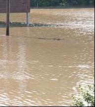
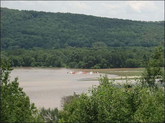
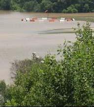
 Town of Colesville Flooding of Porter")


2 Flood of June 2006 (FEMA DR 1650) Sources: Binghamton NWS Forecast Office / Press and Sun-Bulletin (pressconnects.com) Town of Colesville Flooding of Porter Hollow Creek forced the underground pipe through roadway Flooded rivers in Binghamton Lourdes Hospital in Binghamton Memorial Bridge - confluence of Susquehanna and Chenango Rivers in Binghamton Washington Street Bridge along Susquehanna River in Binghamton Washed out roads Flooded house on Conklin Road DMA 2000 Hazard Mitigation Plan Broome County, New York E-2


3 Union Endicott High School Football Fields City of Binghamton - Downtown Union Endicott High School Bleachers House on Route 79 in Windsor Township Parking lot at Town Square Plaza in Vestal, NY Town of Conklin - House dragged off foundation near Schnurbush Park DMA 2000 Hazard Mitigation Plan Broome County, New York E-3


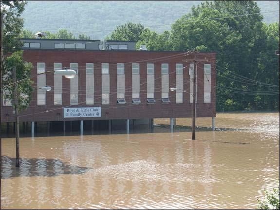


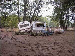
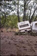
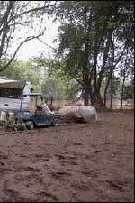


4 Exploded house in Town of Conklin from flood of Susquehanna River. Pine Crest Campgrounds in Town of Windsor Town of Conklin-severe damage as a resulted of adjacent exploded house Tri-Cities Airport Village of Endicott Boys and Girls Club Lourdes Hospital DMA 2000 Hazard Mitigation Plan Broome County, New York E-4


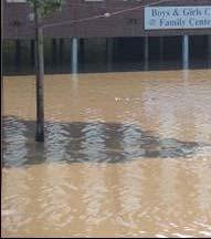
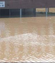
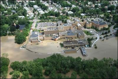
5 The flooded Johnson City-Binghamton Joint Sewage Treatment Facility in Vestal. The Union-Endicott High School, and the Boys and Girls Club in Endicott. The flooded Susquehanna River in Johnson City at left with the AES-Westover plant. A flooded neighborhood in the Tier. The Susquehanna River, bottom, floods the En-Joie Golf Club in Endicott. Flood waters cover Court Street in Binghamton by the McDonald's. DMA 2000 Hazard Mitigation Plan Broome County, New York E-5


6 The Chenango River with the Binghamton Regency in Binghamton. The Susquehanna and Chenango rivers at Confluence Park in Binghamton, with water up to the deck of the Washington The flooded Susquehanna River in Conklin surrounds homes across from Conklin Road near Susquehanna Valley Middle School, upper left. Village of Johnson City Debris from homes as a result of flood waters along Carlton Street. Looking south down Conklin Road of the flooded neighborhoods around Conklin Town Hall. DMA 2000 Hazard Mitigation Plan Broome County, New York E-6

 Source: Binghamton NWS Forecast")


7 Tri Cities Airport Aerial Photograph Appalachin Area Route 17 in Broome County Flood of April 2005 (FEMA DR 1589) Source: Binghamton NWS Forecast Office Flooding at Confluence Park in Binghamton, NY. Flooding at Hill Park Binghamton, NY. DMA 2000 Hazard Mitigation Plan Broome County, New York E-7


8 High water at the South Washington Street Bridge Binghamton, NY. Flooding on the Roberson Museum grounds Binghamton, NY. Golf course in Chenango Bridge, NY. Susquehanna River near Vestal, NY. Flags at the golf course Chenango Bridge, NY. Field flooding near Vestal, NY. DMA 2000 Hazard Mitigation Plan Broome County, New York E-38


9 Ice Jam Flood of March 4, 2004 Source: Binghamton NWS Forecast Office Flooding of the Polar Bear Ice Skating Rink McGirk's Irish Pub suffered major flooding. Taken from the route 12A Bridge - the water backed up due to the ice jam restricting the flow of the Chenango River. The water flooded a golf course, pub and ice skating rink as seen above. The water was several feet deep as the top of a fence post disappeared in the waters. DMA 2000 Hazard Mitigation Plan Broome County, New York E-39


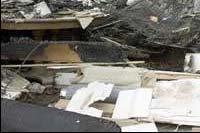
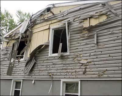
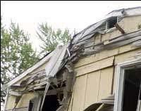
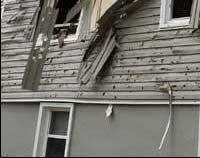
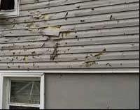
10 May 24, 2004 Tornado Event Source: Binghamton NWS Forecast Office: Tree snapped in the middle of Big Hollow Road near the eastern edge of Broome County, NY. Shed demolished and trees snapped off Big Hollow Road in eastern Broome County, NY. A pile of pea size hail at the National Weather Service Office in Binghamton, NY. Hail ranged from peas to golf ball in size. This same storm produced the F1 tornado in eastern Broome County. DMA 2000 Hazard Mitigation Plan Broome County, New York E-40

11 Hail the size of quarters at the National Weather Service Office in Binghamton, NY. DMA 2000 Hazard Mitigation Plan Broome County, New York E-41
Daily Operations Briefing Wednesday, April 5, :30 a.m. EDT
 Daily Operations Briefing Wednesday, April 5, 2017 8:30 a.m. EDT Significant Activity Apr 4-5 Significant Events: Severe Weather Southern Plains to Southeast Significant Weather: Severe thunderstorms &
Severe Weather. Copyright 2006 InstructorWeb
 Severe Weather People need to know what the weather is going to do. Sometimes severe weather can happen. Severe weather can cause property damage, injuries to people and animals, and even loss of life.
Flood Scenario Worksheet
 Flood Scenario Worksheet Scenario adapted from: http://www.epa.gov/watersecurity/tools/trainingcd/simple/source/scenario-8/ssc8-0.pdf Simple Tabletop Exercise, Interdependency Natural Disaster Scenario,
Appendix C Fluvial Flood Hazards
 Appendix C Fluvial Flood Hazards Sea Level Rise Vulnerability Assessment and Adaptation Project March 2019 Contents Contents... i Figures... i Tables... i Definitions, Acronyms, & Abbreviations... ii
Town of Union Town Board
 Page - 2 - Town of Union Town Board Supervisor John M. Bernardo Council Members Thomas Augostini Frank Bertoni Leonard J. Perfetti Rose A. Sotak Prepared By Town of Union Planning Department 3111 East
Policy Title: Snow Removal & Ice Control Policy #: PW
 Village of Fruitvale Corporate Policy Manual Policy Title: Snow Removal & Ice Control Policy #: PW-2012-01 Section: PUBLIC WORKS Initially Approved: 2012 06 04 Last Reviewed: 2013 05 06 Council Approval:
5.4.2 SEVERE WINTER STORM
 5.4.2 SEVERE WINTER STORM This section provides a profile and vulnerability assessment for the severe winter storm hazard. HAZARD PROFILE This section provides profile information including description,
National Weather Service Des Moines Storm Storm Survey Bradgate and Rolfe Tornadoes of May 22, 2004
 National Weather Service Des Moines Storm Storm Survey Bradgate and Rolfe Tornadoes of May 22, 2004 Brenda Brock, MIC Jeff Johnson, WCM Shane Searcy, ITO Chuck Myers, Senior Forecaster Eric Lenning, ITO
CONGLETON INDUSTRIAL PARK LT 6 EX W 300' & E 350' LT 7 BLK 1, a subdivision of land in the City of Overland Park, Johnson County, Kansas.
 NOTICE OF PUBLIC HEARING CITY PLANNING COMMISSION CITY OF OVERLAND PARK, KANSAS Notice is hereby given that the City Planning Commission of Overland Park, Kansas, will hold a public hearing Monday, July
Tuesday, March 5, :30 a.m. EST
 Tuesday, March 5, 2019 8:30 a.m. EST Significant Activity Mar 4-5 Significant Events: Severe thunderstorms and tornadoes AL and GA Tropical Activity: No activity affecting U.S. interests Significant Weather:
...TORNADO CONFIRMED NEAR SANFORD...BROADWAY...HOLLY SPRINGS AND RALEIGH IN LEE AND WAKE COUNTIES COUNTY NORTH CAROLINA...
 ...TORNADO CONFIRMED NEAR SANFORD...BROADWAY...HOLLY SPRINGS AND RALEIGH IN LEE AND WAKE COUNTIES COUNTY NORTH CAROLINA... LOCATION...SANFORD...BROADWAY...HOLLY SPRINGS AND RALEIGH IN LEE AND WAKE COUNTIES
COLORING PAGES. Follow Raindy the Raindrop as he travels from your house out to sea.
 COLORING PAGES www.hcfcd.org Follow Raindy the Raindrop as he travels from your house out to sea. Raindy the Raindrop falls from the sky and lands on your house or in your neighborhood. Once he s on the
IDENTIFICATION OF HAZARDS OF CONCERN
 IDENTIFICATION OF HAZARDS OF CONCERN To provide a strong foundation for mitigation strategies considered in Section 6, the Village considered a full range of hazards that could impact the area and then
Daily Operations Briefing Tuesday, January 6, :30 a.m. EST
 Daily Operations Briefing Tuesday, January 6, 2015 8:30 a.m. EST Significant Activity: Jan 5-6 Significant Events: Flooding Western WA - FINAL Significant Weather: Snow Northern/Central Rockies to Northern/Central
WHAT HAPPENS WHEN A TORNADO STRIKES THE COMMUNITY? Carroll County Sheriff s Office Emergency Management
 WHAT HAPPENS WHEN A TORNADO STRIKES THE COMMUNITY? Carroll County Sheriff s Office Emergency Management WHAT IS EMERGENCY MANAGEMENT? Carroll County Sheriff s Office Emergency Management Agency is responsible
Tornadoes. Be able to define what a tornado is. Be able to list several facts about tornadoes.
 Tornadoes Be able to define what a tornado is. Be able to list several facts about tornadoes. 1. Where do tornadoes most U.S. is # 1 occur in the world? Tornadoes are most common in Tornado Alley. Tornado
Daily Operations Briefing Monday, March 7, :30 a.m. EST
 Daily Operations Briefing Monday, March 7, 2016 8:30 a.m. EST Significant Activity: March 4-7 Significant Events: None Significant Weather: Severe Thunderstorms Southern Plains Rain/Thunderstorms Pacific
Delaware River Flood Advisory Committee
 Delaware River Flood Advisory Committee A Partnership to Support Flood Mitigation Alan Tamm Pennsylvania Emergency Management Agency Bureau of Recovery and Mitigation atamm@state.pa.us Peter Gabrielsen
PW 001 SNOW REMOVAL AND SANDING FOR ROADWAYS AND SIDEWALKS October 6, 2014 (#223-14) Original October 19, 2015; October 15, 2018 Public Works
 Original October 19, 2015; October 15, 2018 Public Works") Policy Statement: The Village of Kitscoty will provide snow and ice control on municipal streets and sidewalks according to determined priorities. Purpose: To provide direction and information to employees
Policy Statement: The Village of Kitscoty will provide snow and ice control on municipal streets and sidewalks according to determined priorities. Purpose: To provide direction and information to employees
A) The Weather. Write the name of these weather instruments: (4 marks)
 The Weather. Write the name of these weather instruments: (4 marks)") always Creative, Innovative, Professional HALF YEARLY EXAMINATIONS Maria Regina College Scholastic Year 2014/2015 YEAR 4 SOCIAL STUDIES TIME: 1hour Name: Class: School: Total mark 80 A) The Weather. Write
always Creative, Innovative, Professional HALF YEARLY EXAMINATIONS Maria Regina College Scholastic Year 2014/2015 YEAR 4 SOCIAL STUDIES TIME: 1hour Name: Class: School: Total mark 80 A) The Weather. Write
SIGNIFICANT EVENTS Severe Storms November 1994 January 1996 August 1998 and May 2000 March 2002 May 2002 Champaign County
 SIGNIFICANT EVENTS Severe Storms November 1994 On Nov. 1, 1994, high winds gusted over 60 mph at times across the northwest third of Ohio. The highest measured wind gust was 63 mph at Columbus Grove (Putnam).
Hurricane Preparation and Recovery. October 11, 2011 Jon Nance, Chief Engineer, NCDOT
 Hurricane Preparation and Recovery October 11, 2011 Jon Nance, Chief Engineer, NCDOT North Carolina & Severe Weather Our state often bears the brunt of storms, which include: Ice storms Snow storms Heavy
Daily Operations Briefing. Friday, June 20, :30 a.m. EDT
 Daily Operations Briefing Friday, June 20, 2014 8:30 a.m. EDT Significant Activity: June 19 20 Significant Events: Severe Weather/Flooding Upper Midwest Tropical Activity: Atlantic Area 1 Low (10%) Eastern
THE IMPACT OF WEATHER
 The United States is the most severe weather prone country in the world. Each year, people in this country cope with an average of 10,000 thunderstorms, 5,000 floods, 1,200 tornadoes and two landfalling
City of Brainerd, Minnesota Snowplowing Policy
 City of Brainerd, Minnesota Snowplowing Policy 1. Introduction The city of Brainerd, Minnesota, finds that it is in the best interest of the residents of the city to assume basic responsibility for control
Wyoming State Operations Center
 Wyoming State Operations Center Updated Situation Report, Bordeaux Tornado site 14: 36 hrs 8 June 2012 Wyoming Office of Homeland Security (WOHS) arrived at the incident command post at the corner of Olson
KENTUCKY HAZARD MITIGATION PLAN RISK ASSESSMENT
 KENTUCKY HAZARD MITIGATION PLAN RISK ASSESSMENT Presentation Outline Development of the 2013 State Hazard Mitigation Plan Risk Assessment Determining risk assessment scale Census Data Aggregation Levels
Severe Weather Watches, Advisories & Warnings
 Severe Weather Watches, Advisories & Warnings Tornado Watch Issued by the Storm Prediction Center when conditions are favorable for the development of severe thunderstorms and tornadoes over a larger-scale
SPEARFISH FIRE DEPARTMENT POLICIES AND PROCEDURES
 SPEARFISH FIRE DEPARTMENT POLICIES AND PROCEDURES Page 1 of 5 Volume: Operation Section: 20.00 Number: 20.09 Subject: Weather Watches, Warnings, Advisory s and Spotter Activation Date Issued: 28 March
FLORIDA DIVISION OF EMERGENCY MANAGEMENT STATE WATCH OFFICE DAILY INCIDENT REPORT
 FLORIDA DIVISION OF EMERGENCY MANAGEMENT STATE WATCH OFFICE DAILY INCIDENT REPORT Incident Number: 2018-7477 Incident Name: Woodville Highway Closed Occurred: 12/6/2018 05:29 ET Reported to SWO: 12/6/2018
California OES Weather Threat Briefing
 California OES Weather Threat Briefing Wednesday, January 16, 2019 9:00 AM PST Day 1: Strong winds, heavy mountain snow and heavy rain with isolated thunderstorms across much of the state through Thursday
IWT Scenario 2 Integrated Warning Team Workshop National Weather Service Albany, NY October 31, 2014
 IWT Scenario 2 Integrated Warning Team Workshop National Weather Service Albany, NY October 31, 2014 09 10 11 12 13 Scenario 2 Timeline December 9-13 Tue Wed Thu Fri Sat Tue, Dec. 9 @ 5 am 2014 2014 2014
SEVERE WEATHER 101. Flood Basics
 SEVERE WEATHER 101 Flood Basics What is flooding? Flooding is an overflowing of water onto land that is normally dry. Floods can happen during heavy rains, when ocean waves come on shore, when snow melts
2012 FLOODS AND DEBRIS REMOVAL
 2012 FLOODS AND DEBRIS REMOVAL June 2012 2012 Floods Tuesday, June 19 AFTERNOON Severe thunderstorms roll across much of the Northland, dropping hail and an initial round of heavy rain in many areas, including
MAPS AND THEIR CLASSIFICATION
 MAPPING MAPS AND THEIR CLASSIFICATION WHAT IS A MAP? A map is representation of the Earth's surface, showing how things are related to each other by distance, direction, and size. Maps are a way of showing
Running Head: HAZARD MITIGATION PLAN OUTLINE FOR MISSISSIPPI 1
 Running Head: HAZARD MITIGATION PLAN OUTLINE FOR MISSISSIPPI 1 Hazard Mitigation Plan Outline for Mississippi Name: Institution: HAZARD MITIGATION PLAN OUTLINE FOR MISSISSIPPI 2 Hazard Mitigation Plan
National Geography Challenge Sample Questions
 Grade 2 1. The continent on which the United States is located is. A. Asia B. North America C. Europe D. South America 2. The globe is a model of Earth in the shape of a. A. sphere B. circle C. ring D.
Daily Operations Briefing Saturday, March 5, :30 a.m. EST
 Daily Operations Briefing Saturday, March 5, 2016 8:30 a.m. EST Significant Activity: March 5 Significant Events: None Significant Weather: Snow Parts of the Upper Great Lakes and Central Appalachians
SNOW REMOVAL GUIDE. City Of Orange Township. Public Works Snow Removal Hotline: (973) My Orange Hotline: (973)
 My Orange Hotline: (973)") Mayor Dwayne D. Warren, Esq. And The Orange Municipal Council MOVING ORANGE FORWARD City Of Orange Township SNOW REMOVAL GUIDE Public Works Snow Removal Hotline: (973) 266-4030 My Orange Hotline: (973)
Mayor Dwayne D. Warren, Esq. And The Orange Municipal Council MOVING ORANGE FORWARD City Of Orange Township SNOW REMOVAL GUIDE Public Works Snow Removal Hotline: (973) 266-4030 My Orange Hotline: (973)
CHAPTER 10 LIGHTNING
 CHAPTER 10 LIGHTNING Lightning is a sudden electrical discharge released from the atmosphere that follows a course from cloud to ground, cloud to cloud, or cloud to surrounding air, with light illuminating
Daily Operations Briefing Saturday, June 27, :30 a.m. EDT
 Daily Operations Briefing Saturday, June 27, 2015 8:30 a.m. EDT Significant Activity: June 26-27 Significant Events: None Tropical Activity: Atlantic: Tropical cyclone activity not expected next 48 hours
April snowmelt and record rainfall resulted in flooding across portions of Vermont
 Vermont State Climate Office Climate Impacts Summary April 2011 Dr. Lesley-Ann Dupigny-Giroux Stephen Hogan April snowmelt and record rainfall resulted in flooding across portions of Vermont During the
Daily Operations Briefing Tuesday, March 28, :30 a.m. EDT
 Daily Operations Briefing Tuesday, March 28, 2017 8:30 a.m. EDT Significant Activity Mar 27-28 Significant Events: None Significant Weather: Severe Thunderstorms TX & OK Flash Flooding TX & OK Freezing
Page G Crow Wing County Multi-Hazard Mitigation Plan, 2017
 Table G - 10. s Identified by the () (From Crow Wing County Master Chart) 1 5 All- Hazards All- Hazards Work to ensure that all Crow Wing County residents are aware of and sign-up for the County s Emergency
Daily Operations Briefing Wednesday, February 3, :30 a.m. EST
 Daily Operations Briefing Wednesday, February 3, 2016 8:30 a.m. EST Significant Activity: February 2-3 Significant Events: None Significant Weather: Flash Flooding Southeast to New England Freezing Rain
Daily Operations Briefing Tuesday, April 4, :30 a.m. EDT
 Daily Operations Briefing Tuesday, April 4, 2017 8:30 a.m. EDT Significant Activity Apr 3-4 Significant Events: Severe Weather Southern Plains to Southeast Significant Weather: Severe Thunderstorms and
CASA WX DFW URBAN DEMONSTRATION NETWORK
 CASA WX DFW URBAN DEMONSTRATION NETWORK Goals Background on Regional CASA WX Project Explain the capabilities, structure of the Radar Network Present the CASA WX DFW Test Bed will be rolled out Describe
Daily Operations Briefing Saturday, March 26, :30 a.m. EDT
 Daily Operations Briefing Saturday, March 26, 2016 8:30 a.m. EDT Significant Activity: March 25-26 Significant Events: None Significant Weather: Rain Pacific Northwest to Northern Intermountain; Southern
Daily Operations Briefing Monday, March 30, :30 a.m. EDT
 Daily Operations Briefing Monday, March 30, 2015 8:30 a.m. EDT Significant Activity: Mar 27 30 Significant Events: Pacific earthquakes; no tsunami Significant Weather: Snow Upper Great Lakes and Northern
CHAPTER 10. TORNADOES AND WINDSTORMS
 CHAPTER 10. TORNADOES AND WINDSTORMS Wyoming, lying just west of tornado alley, is fortunate to experience less frequent and intense tornadoes than its neighboring states to the east. However, tornadoes
Timeframe. Crow Wing County, Baxter, Brainerd, Breezy Point, Crosby, Crosslake, Cuyuna, Deerwood, Emily, Fifty
 Table G - 13. s Identified for by the () (From Crow Wing County Master Chart) 1 5 9 All- Hazards All- Hazards Winter Work to ensure that all Crow Wing County residents are aware of and sign-up for the
Pre-Disaster Natural Hazard Mitigation Plan Guilford, Connecticut History of Hazard Mitigation Planning Authority Disaster Mitigation Act of 2000 (ame
 Pre-Disaster Natural Hazard Mitigation Plan Guilford, Connecticut History of Hazard Mitigation Planning Authority Disaster Mitigation Act of 2000 (amendments to Stafford Act of 1988) Presented by: David
AASHTO Extreme Weather Events Symposium Vermont s Road and Rivers - Managing for the Future
 AASHTO Extreme Weather Events Symposium Vermont s Road and Rivers - Managing for the Future May 22, 2013 PLANET EARTH 2 2 MANY MANYYEARS AGO 23,000 years ago there was more than 8,000 feet of glacier over
Monitoring Scour Critical Bridges During Floods For Local Bridge Owners. Presented by
 Monitoring Scour Critical Bridges During Floods For Local Bridge Owners Presented by SAFETY FIRST DO NOT ENDANGER YOURSELF OR OTHERS WHILE MONITORING BRIDGES DO NOT ENTER FLOOD WATERS FLOOD WATERS INCLUDE
Objective: Demonstrate the ability to utilize the full range of ICS command, control, and coordination options to organize a disaster.
 Objective: Demonstrate the ability to utilize the full range of ICS command, control, and coordination options to organize a disaster. Instructions: 1. You will be assigned to one of the following four
Winter Weather. National Weather Service Buffalo, NY
 Winter Weather National Weather Service Buffalo, NY Average Seasonal Snowfall SNOWFALL = BIG IMPACTS School / government / business closures Airport shutdowns/delays Traffic accidents with injuries/fatalities
Superstorm Sandy What Risk Managers and Underwriters Learned
 Superstorm Sandy What Risk Managers and Underwriters Learned Gary Ladman Vice President, Property Underwriting AEGIS Insurance Services, Inc. Superstorm Sandy Change in the Weather Recent years appears
Town of Windsor. Department of Public Works
 Town of Windsor Department of Public Works 860.285.1855 TOWN OF WINDSOR PUBLIC WORKS SNOW REMOVAL PLAN In Windsor, as throughout the New England states, winter can bring a variety of weather conditions
National Situation Report As of 5:00 a.m. EDT Wednesday, April 5, 2017
 Overview National Situation Report As of 5:00 a.m. EDT Wednesday, April 5, 2017 Table Of Contents Current Operations Monitoring Recovery National Response Coordination Center: Not Activated National Watch
Kentucky Weather Hazards: What is Your Risk?
 Kentucky Weather Hazards: What is Your Risk? Stuart A. Foster State Climatologist for Kentucky 2010 Kentucky Weather Conference Bowling Green, Kentucky January 16, 2010 Perspectives on Kentucky s Climate
GIS Monroe Geographic Information System March 14, 2018
 GIS Monroe Geographic Information System March 14, 2018 Goals Maintain Enterprise/County-wide geo-database Increase spatial accuracy of data Build and acquire more data layers Increase use of GIS; as another
Hurricane Season 2018
 Hurricane Season 2018 Mission Protect LIFE and Property (Save Lives and Livelihoods) NOAA/ National Weather Service We are NOT a 9-to-5 agency. We operate 24/7/365 serving communities. We are available
Unit 4. This unit will enable you to improve coordination and communication with State and local agencies when hazardous weather threatens.
 Unit 4 This unit will enable you to improve coordination and communication with State and local agencies when hazardous weather threatens. In this unit we will discuss the role of Emergency Managers in
Thursday, March 7, :30 a.m. EST
 Thursday, March 7, 2019 8:30 a.m. EST Significant Activity Mar 6-7 Significant Events: Severe thunderstorms and tornadoes AL and GA (FINAL) Tropical Activity: No activity affecting U.S. interests Significant
CITY OF NEW LONDON WINTER ROAD & SIDEWALK MAINTENANCE POLICY
 CITY OF NEW LONDON WINTER ROAD & SIDEWALK MAINTENANCE POLICY GENERAL The purpose of this policy is to set up acceptable procedures and policies for the winter maintenance of public areas in the City of
April 16, Tornado Damage Survey
 April 16, 2011 - Tornado Damage Survey Below is information on the storm damage surveys conducted by the National Weather Service in Wakefield, VA. Appreciation is extended to county officials and property
Flooding and Severe weather of 27 June 2013
 Flooding and Severe weather of 27 June 2013 By Richard H. Grumm National Weather Service State College, PA 1. Overview Flooding and severe weather affected Pennsylvania on 27 June 2013 (Fig 1). The severe
Daily Operations Briefing Monday, March 21, :30 a.m. EDT
 Daily Operations Briefing Monday, March 21, 2016 8:30 a.m. EDT Significant Activity: March 18-21 Significant Events: None Significant Weather: Rain and snow: Pacific northwest to Central Rockies across
Winter Weather Threat Friday night and Saturday January 7, 2017
 Winter Weather Threat Friday night and Saturday January 7, 2017 National Weather Service Newport/Morehead City, NC Date/Time Created: 1/6/2017, 6 AM EST Winter Weather Threat Summary Tonight and Saturday
PENNSYLVANIA DEPARTMENT OF TRANSPORTATION ENGINEERING DISTRICT 3-0
 PENNSYLVANIA DEPARTMENT OF TRANSPORTATION ENGINEERING DISTRICT 3-0 LYCOMING COUNTY S.R.15, SECTION C41 FINAL HYDROLOGIC AND HYDRAULIC REPORT STEAM VALLEY RUN STREAM RELOCATION DATE: June, 2006 REVISED:
[Leveraging & Improving Neighborhood Connections] Area E Cedar Creek
![[Leveraging & Improving Neighborhood Connections] Area E Cedar Creek](/thumbs/86/93508963.jpg "[Leveraging & Improving Neighborhood Connections] Area E Cedar Creek") Community Charrette LINC Dallas [Leveraging & Improving Neighborhood Connections] Area E Cedar Creek 06.02.12 LINC Workshop Area E Area E has the unique distinction of at-grade frontage to the Trinity
Community Charrette LINC Dallas [Leveraging & Improving Neighborhood Connections] Area E Cedar Creek 06.02.12 LINC Workshop Area E Area E has the unique distinction of at-grade frontage to the Trinity
Comanche County Emergency Management and local fire/police crews continue to assess damage Wednesday morning.
 Comanche County Emergency Management and local fire/police crews continue to assess damage Wednesday morning. Constitution Article An unexpected burst of severe weather and violent wind gusts blew through
Data Dictionary Hudson River Features: Estuary shoreline Flood scenario Emergency Services: Police stations Fire stations EMS
 Data Dictionary Hudson River Features: Estuary shoreline This data layer represents the border of the Hudson River in our study area. New York State Department of Environmental Conservation. 2009. Hudson
Table G - 6. Mitigation Actions Identified for Implementation by the City of Kent ( ) (From Wilkin County Master Mitigation Action Chart)
 (From Wilkin County Master Mitigation Action Chart)") Table G - 6. Actions Identified by the () (From Master Action Chart) Multi-Hazard Plan, 2017 Action Comments 5 All-Hazards Local Planning & Regulations Update the Operations Plan on an annual basis. Work
Table G - 6. Actions Identified by the () (From Master Action Chart) Multi-Hazard Plan, 2017 Action Comments 5 All-Hazards Local Planning & Regulations Update the Operations Plan on an annual basis. Work
Satellite and Radar. 5:55 am Infrared Satellite with Surface Wind Arrows. 6:15 am Ruskin Doppler Radar. Large southerly wind field
 Satellite and Radar 5:55 am Infrared Satellite with Surface Wind Arrows 6:15 am Ruskin Doppler Radar Large southerly wind field Developing showers rotating onshore NHC Forecast Hurricane Warning Big Bend
Technical Memorandum. City of Salem, Stormwater Management Design Standards. Project No:
 Technical Memorandum 6500 SW Macadam Avenue, Suite 200 Portland, Oregon, 97239 Tel: 503-244-7005 Fax: 503-244-9095 Prepared for: Project Title: City of Salem, Oregon City of Salem, Stormwater Management
Chippewa County Natural Hazards Mitigation Plan
 2014 Chippewa County Natural Hazards Mitigation Plan Prepared for: Chippewa County Office of Emergency Management With the Assistance of: Eastern U.P. Regional Planning & Development Commission April,
Summer Safety Campaign
 Summer Safety Campaign Author Day Month Year Overall classification of this briefing is. Summer Safety Campaign Key Emphasis Heat Injury Five steps of heat injury risk management Mild and extreme heat
Alluvial Fan Flooding Workshop. Barry Pierce National Weather Service, Las Vegas
 Alluvial Fan Flooding Workshop Barry Pierce National Weather Service, Las Vegas Death Valley NP, August 15, 2004 Outline National Weather Service Alluvial Fan/Flash Flooding Weather Regimes Conducive For
Section 9: Hail. Contents. Why Hailstorms Are a Threat
 Section 9: Hail Contents Why Hailstorms Are a Threat...9-1 Hazard Profile...9-2 History of Hailstorms...9-3 People and Property at Risk...9-10 Potential Damages and Losses...9-11 Why Hailstorms Are a Threat
November 22, 1992, I-71, Carroll County KY by Irma Doran
 November 22, 1992, I-71, Carroll County KY by Irma Doran The World s First Tornado Scientist 1885 April 26, 1884 near Garnett, KS by A.A. Adams The World s First Tornado Photograph August 28, 1884
Erosion Information Paper Eagle City and Eagle Village, Alaska Current as of January 21, 2008
 U.S. Army Corps of Engineers ALASKA BASELINE EROSION ASSESSMENT Erosion Information Paper Eagle City and Eagle Village, Alaska Current as of January 21, 2008 Community Information The City of Eagle, population
Preparing for the BIG one Cascadia Subduction Zone Event
 Preparing for the BIG one Cascadia Subduction Zone Event Source - 2016 CZS Excercise updated Jan 2015 1 Earthquake Faults in Washington State Emergency Management Ring of Fire The Ring of Fire accounts
GWINNETT COUNTY GEORGIA AMATEUR RADIO EMERGENCY SERVICE. Operations Plan
 GWINNETT COUNTY GEORGIA AMATEUR RADIO EMERGENCY SERVICE Operations Plan National Weather Service Support Plan 100 (Operation SKYWARN) September 21, 2002 (Revised July 14, 2003) National Weather Service
IN VEHICLES: Do not try to outrun a tornado. Abandon your vehicle and hide in a nearby ditch or depression and cover your head.
 TORNADO SAFETY TORNADO! The very word strikes fear in many people. While a tornado is perhaps nature's most destructive storm, deaths and injuries can be prevented. By following Tornado Safety Rules, lives
Daily Operations Briefing Thursday, December 24, :30 a.m. EST
 Daily Operations Briefing Thursday, December 24, 2015 8:30 a.m. EST Significant Activity: Dec 23-24 Significant Events: Severe Weather Eastern U.S. Significant Weather: Severe Thunderstorms/ Flash Flooding
Daily Operations Briefing. Saturday, June 21, :30 a.m. EDT
 Daily Operations Briefing Saturday, June 21, 2014 8:30 a.m. EDT Significant Activity: June 20 21 Significant Events: Severe Weather/Flooding Upper Midwest (Final) Tropical Activity: Atlantic Area 1 Low
Vermont State Climate Office Climate Impacts Summary December Dr. Lesley-Ann Dupigny-Giroux Stephen Hogan
 Vermont State Climate Office Climate Impacts Summary December 2010 Dr. Lesley-Ann Dupigny-Giroux Stephen Hogan December 2010 was marked by a number of severe events including wind damage, large snowfalls
Daily Operations Briefing Wednesday, July 6, :30 a.m. EDT
 Daily Operations Briefing Wednesday, July 6, 2016 8:30 a.m. EDT Significant Activity: July 5-6 Significant Events: Severe Weather Plains to Ohio Valley Tropical Activity: Atlantic Tropical cyclone activity
Why was this eruption important?
 Mount St. Helens Mount St. Helens has a long geological history (>3,000 yrs) of explosive eruptions. The 1980 Events: Initial relatively mild steam and ash (Vulcanian) eruptions. Sustained plinian eruption
Daily Operations Briefing Friday, November 29, :30 a.m. EST
 Daily Operations Briefing Friday, November 29, 2013 8:30 a.m. EST 1 Significant Activity: Nov 27 29 Significant Events: Winter Storm Eastern US (Final) Tropical Activity: Atlantic Area 1 (Low chance/10%)
HAZARD DESCRIPTION... 1 LOCATION... 1 EXTENT... 1 HISTORICAL OCCURRENCES...
 WINTER STORM HAZARD DESCRIPTION... 1 LOCATION... 1 EXTENT... 1 HISTORICAL OCCURRENCES... 3 SIGNIFICANT PAST EVENTS... 4 PROBABILITY OF FUTURE EVENTS... 5 VULNERABILITY AND IMPACT... 5 Hazard Description
September 13, 2018 MEDIA RELEASE. Waynesboro Department of Emergency Management Waynesboro Police Department Waynesboro Fire Department
 MEDIA RELEASE September 13, 2018 The City continues to prepare for and monitor the track and potential impacts of Hurricane Florence. Current guidance from the National Weather Service, the National Hurricane
Some Applications of trigonometry
 Some Applications of trigonometry 1. A flag of 3m fixed on the top of a building. The angle of elevation of the top of the flag observed from a point on the ground is 60º and the angle of depression of
PUBLIC INFORMATION STATEMENT...UPDATED FATALITY INFO NATIONAL WEATHER SERVICE RALEIGH NC 435 PM EDT MON APR
 PUBLIC INFORMATION STATEMENT...UPDATED FATALITY INFO NATIONAL WEATHER SERVICE RALEIGH NC 435 PM EDT MON APR 18 2011...MULTIPLE TORNADOES CONFIRMED ON APRIL 16 2011......TORNADO CONFIRMED NEAR WAYSIDE TO
Long Term Plan What is planned for Murchison?
 Long Term Plan 2018-2028 What is planned for Murchison? 1.0 Introduction The following information provides an overview of significant projects Council has planned for the Murchison settlement in the Long
Hurricane Florence Recovery Report 4:00 PM October 31, 2018
 Hurricane Florence Recovery Report 4:00 PM October 3, 208 SCDOT Operations Mode: Recovery Statewide Summary There are 2 road closures on primary and secondary routes due to damage or flooding throughout
Date: 27 April UF Research Contract Number: Project Date: Project Start: 6 November 2017 Project End: 30 June 2018
 Date: 27 April 2018 Project: Performance of Single-Family Residential Buildings in Hurricane Irma Evaluating the Impact of the 1st March 2002 Florida Building Code and Homeowner/Occupant Survey on Risk
Dunn County Snow Removal Policy
 Dunn County Snow Removal Policy OVERVIEW With the advent of another winter season in the northern plains comes the possibility of snow, freezing rain and slippery roadways, and area resident s concern
1951 Flood Photograph Collection
 1951 Flood Photograph Collection This collection of 30 photographs provides images of the 1951 flood taken in the Kansas City area. Descriptive Summary Creator: Unknown Title: 1951 Flood photograph collection