2012 FLOODS AND DEBRIS REMOVAL
|
|
|
- Kory Merritt
- 5 years ago
- Views:
Transcription
1 2012 FLOODS AND DEBRIS REMOVAL
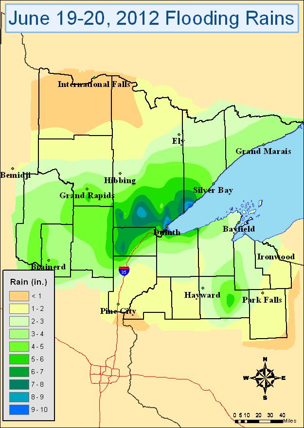
2 June 2012
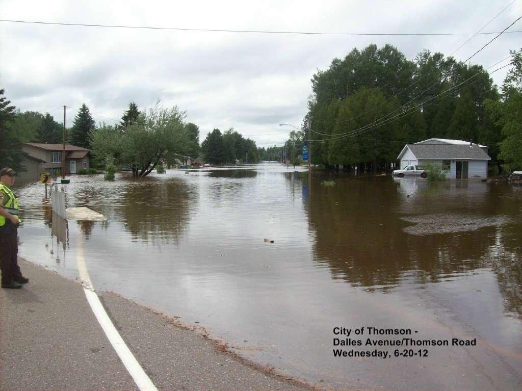
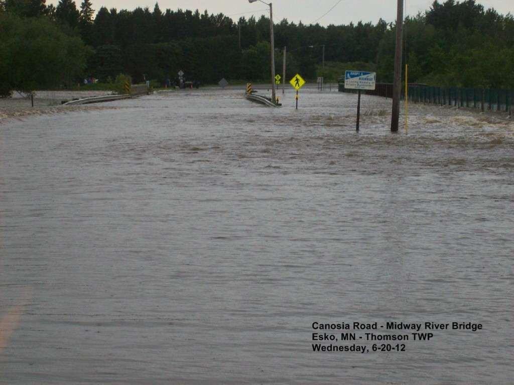
3 2012 Floods Tuesday, June 19 AFTERNOON Severe thunderstorms roll across much of the Northland, dropping hail and an initial round of heavy rain in many areas, including 2 inches in Floodwood. Flash flood watch continues. The News Tribune starts its severe weather live blog, which will continue on-and-off, as time allows, for the next 2½ days. Wednesday June 20 12:07 A.M. Longer-duration flood warning issued for areas including Cloquet, Moose Lake, Carlton, Floodwood, Aitkin, Grand Rapids, Hibbing and Ely until noon 1:30 A.M. Carlton County Sherriff called into work 3:52 A.M. Initial reports of a polar bear missing from its enclosure at the Lake Superior Zoo. Police and fire officials assisting zoo staff in tracking down animals unaccounted for on zoo grounds. ABOUT 5:30 A.M. Carlton County Sheriff s Office recommends no travel in county; evacuations recommended in Thomson area; Highway 210 closed in Jay Cooke State Park.
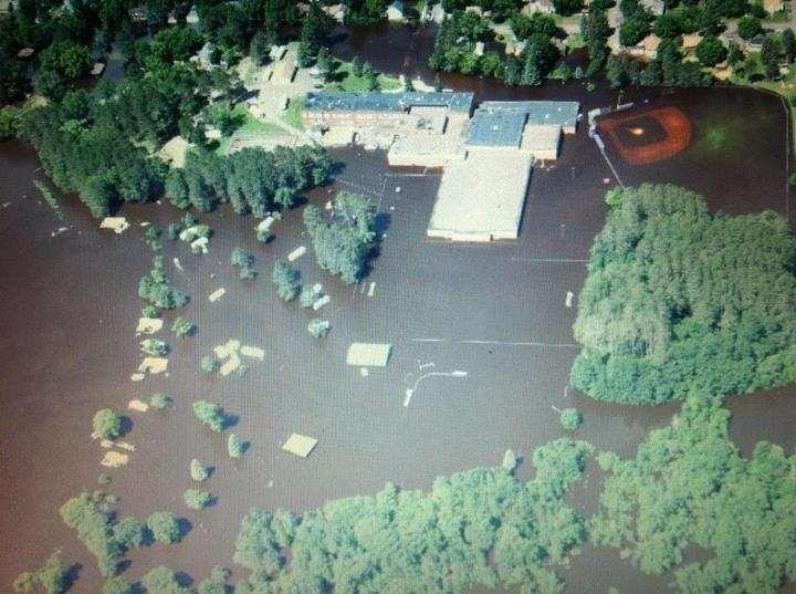
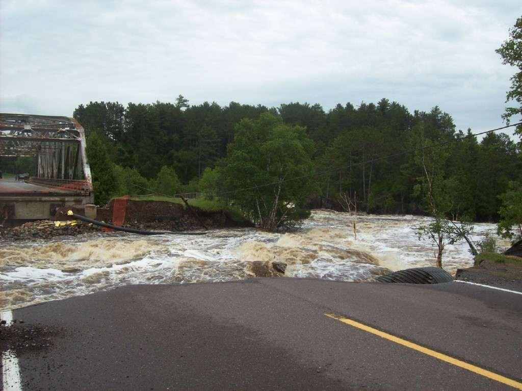
4 2012 Floods Thursday, June 21 EARLY MORNING Rising waters of Moosehead Lake start to encroach on homes in Moose Lake; water continues to rise throughout the day. Floodwaters from the St. Louis River continue to affect homes in Floodwood and Brookston. 6 A.M. Interstate 35 remains closed in both directions between Carlton and Mahtowa, and Highway 23 remains closed at Fond du Lac. With so many county and town roads also flooded, finding alternate routes between Duluth and the Twin Cities is difficult if not impossible without traveling long distances. 10:26 A.M. The National Weather Service issues a new flash flood warning for Duluth, Superior and Cloquet until 10:30 p.m. 10:30 A.M. Interstate 35 reported closed near Carlton. 2:15 P.M. Reports that parts of the city of Carlton near the Thomson Reservoir are being evacuated; a few hours later 1 to 2 feet of standing water is reported in the center of town.
5 2012 Floods 3:34 P.M. State of emergency declared in Wrenshall 4:45 P.M. The St. Louis River at Scanlon, reaches its highest level on record: feet, more than a half-foot above the previous record set in The River Inn in Scanlon is damaged by the high water. 4:50 P.M. Interstate 35 is reported to be open again within the city of Duluth, but remains closed south of Carlton. Thursday, June 21 EARLY MORNING Rising waters of Moosehead Lake start to encroach on homes in Moose Lake; water continues to rise throughout the day. Floodwaters from the St. Louis River continue to affect homes in Floodwood and Brookston. 6 A.M. Interstate 35 remains closed in both directions between Carlton and Mahtowa, and Highway 23 remains closed at Fond du Lac. With so many county and town roads also flooded, finding alternate routes between Duluth and the Twin Cities is difficult if not impossible without traveling long distances. MID-MORNING Minnesota Gov. Mark Dayton, Duluth Mayor Don Ness and other local and state officials tour damage at several locations in the city. Dayton pledges quick help from the state for the terrible devastation. Damage estimates exceed $100 million region-wide and that s just for public roads and facilities, not private property.
6
7
8
9
10
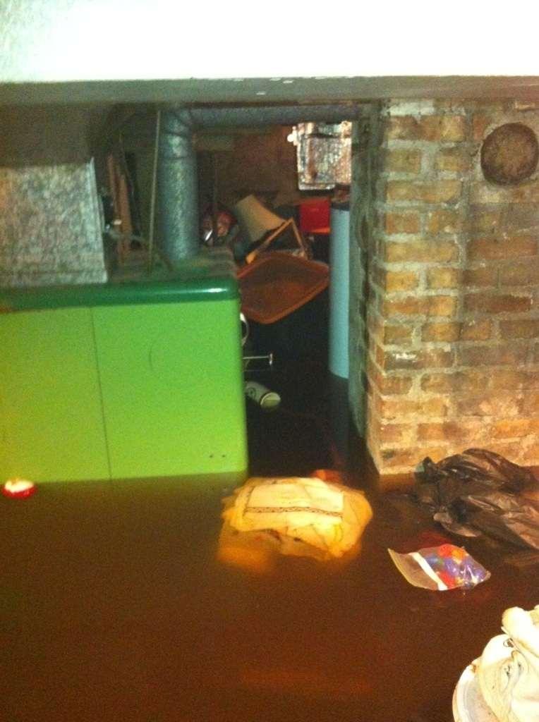
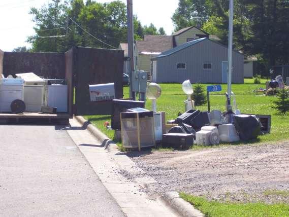
11 2012 Floods June 25, 2012 Carlton County Administrator Passed a Comprehensive Debris Management Plan Unanimously June 26 July 31, 2012: Debris Removal Free disposal of curbside flood debris at Carlton County Transfer Station and Shamrock Landfill. Extended hours at Carlton County Transfer Station and Shamrock Landfill. Extended hours and days at Carlton County Household Hazardous Waste Facility. Temporary transfer stations were established at the Barnum County Garage and Cromwell County Garage. Staff from Stearns County Environmental Services, Minnesota Department of Agriculture and Minnesota Pollution Control Agency were utilized at the temporary transfer stations to help residents unload and sort curbside flood debris Curbside flood debris removal was conducted county-wide by two contractors. A flood debris coordinator was contracted to receive calls from residents who had their flood debris sorted and ready for pickup at the curb.

12
13

14

15

16
17
18 2012 Floods Key Elements Carlton County passed without hesitation an comprehensive Debris Management Plan this was key because it allowed for decisions to be made to manage all the debris with much flexibility Approved Shamrock to accept all flood related debris Set up temporary transfer stations for convenience Expanded all transfer station and landfill hours Got MnDOT approval to transport waste without being stopped at any check points Seamless partnership between County, State, and all private sector entities Conducted regular meetings throughout the County and provided daily updates via many media outlets Provided a number that anyone could call in order to ask questions or get their debris picked up
19 To date we have received the first payment of $526, in reimbursement from the State and Federal Government. We expect that the remaining portion will be reimbursed Floods The Numbers: Labor Overtime: $2, (only overtime was eligible for FEMA reimbursement) Materials: $32.06 (signs at temporary stations) Contracts: $536, (debris removal contractors, roll-offs and disposal fees) Administrative Costs: claim) $1, (preparing FEMA Total: $540,196.15
20 2012 Floods Stuff Moved: Approximately 12,500 cubic yards of demolition/solid waste was removed and disposed, not including appliances, electronics or household hazardous waste. This equates to 6,250,000 pounds or 3,123 tons of demolition/solid waste that was removed and disposed. To put that in perspective, the Carlton County Transfer Station takes in approximately 3,700 tons of construction and demolition waste in one year. Approximately 190 appliances, 71 mattresses and 205 electronic units were disposed of as flood debris. Approximately 9,500 pounds of household hazardous waste was disposed of as flood debris.
21 Public Assistance Debris Management Guide FEMA P-325 / July Public Assistance Applicant Handbook FEMA 323 / March bk.pdf
Hurricane Preparation and Recovery. October 11, 2011 Jon Nance, Chief Engineer, NCDOT
 Hurricane Preparation and Recovery October 11, 2011 Jon Nance, Chief Engineer, NCDOT North Carolina & Severe Weather Our state often bears the brunt of storms, which include: Ice storms Snow storms Heavy
Press Release. March 12, 2018
 COUNTY EXECUTIVE OFFICE 105 E. Anapamu St., Fourth Floor, Santa Barbara CA 93101 (805) 568-3400 FAX (805) 568-3414 Contact: Santa Barbara County Joint Information Center 805-696-1188 Media Only Press Release
Town of Barnstable. Department of Public Work. Snow and Ice Control Operations Plan
 Town of Barnstable Department of Public Work Snow and Ice Control Operations Plan I. Mission: The mission of the Department of Public Works is to remove accumulations of snow and ice from town, county
Severe Weather Potential for Southeast Texas
 Severe Weather Potential for Southeast Texas Dan Reilly, Kent Prochazka, Scott Overpeck National Weather Service Houston/Galveston 10 am Synopsis Storm to likely bring severe weather to Southeast Texas
September 13, 2018 MEDIA RELEASE. Waynesboro Department of Emergency Management Waynesboro Police Department Waynesboro Fire Department
 MEDIA RELEASE September 13, 2018 The City continues to prepare for and monitor the track and potential impacts of Hurricane Florence. Current guidance from the National Weather Service, the National Hurricane
FLOOD/SCS EVENT, APRIL 28 MAY 4
 REPORT DATE: May 4, 2017 EVENT DATE: April 28-May 4, 2017 FLOOD/SCS EVENT, APRIL 28 MAY 4 Event Summary General Significant Flood Outlook. SOURCE: National Weather Service. A significant severe thunderstorm
September 20, 2012 TFMA 2012 Fall Conference, Rockwall, Texas
 September 20, 2012 TFMA 2012 Fall Conference, Rockwall, Texas Martha Juch, P.E., CFM, D.WRE Project Director, AECOM Served as President of Upper Brushy WCID Board during T.S. Hermine Melinda Luna, P.E.,
California OES Weather Threat Briefing
 California OES Weather Threat Briefing Wednesday, January 16, 2019 9:00 AM PST Day 1: Strong winds, heavy mountain snow and heavy rain with isolated thunderstorms across much of the state through Thursday
Daily Operations Briefing Wednesday, April 5, :30 a.m. EDT
 Daily Operations Briefing Wednesday, April 5, 2017 8:30 a.m. EDT Significant Activity Apr 4-5 Significant Events: Severe Weather Southern Plains to Southeast Significant Weather: Severe thunderstorms &
Temporary College Closure Due to Inclement Weather or Other Adverse Conditions.
 OTHER TOPICS Index No. X-1 PROCEDURES MEMORANDUM TO: FROM: SUBJECT: MCC Students and Staff Office of the President Temporary College Closure Due to Inclement Weather or Other Adverse Conditions. DATE:
United States Multi-Hazard Early Warning System
 United States Multi-Hazard Early Warning System Saving Lives Through Partnership Lynn Maximuk National Weather Service Director, Central Region Kansas City, Missouri America s s Weather Enterprise: Protecting
A Prepared Marylander Creates a Resilient Maryland
 Maryland Emergency Management Agency Operations Directorate Hazardous Winter Weather Outlook Briefing March 5, 2013 0800 A Prepared Marylander Creates a Resilient Maryland A strong low pressure will track
ICE STORM! a mini tabletop exercise for home care agencies
 1 ICE STORM! a mini tabletop exercise for home care agencies HCA Education and Research Winter 2010 2011 2 What is a tabletop exercise? People come together to review and discuss a hypothetical emergency
Flood Scenario Worksheet
 Flood Scenario Worksheet Scenario adapted from: http://www.epa.gov/watersecurity/tools/trainingcd/simple/source/scenario-8/ssc8-0.pdf Simple Tabletop Exercise, Interdependency Natural Disaster Scenario,
City of Madison Flooding Event AUGUST 20 TH, 2018-PRESENT
 City of Madison Flooding Event AUGUST 20 TH, 2018-PRESENT Presentation Overview Review of Flash Flooding and Flooding from High Lake Levels (August 20 th -Present) Lake Level Information Damages FEMA How
Daily Operations Briefing Tuesday, March 10, :30 a.m. EDT
 Daily Operations Briefing Tuesday, March 10, 2015 8:30 a.m. EDT Significant Activity: Mar 9 10 Significant Events: None Significant Weather: Rain and thunderstorms Gulf Coast to Mid-Atlantic and Southeast
IWT Scenario 2 Integrated Warning Team Workshop National Weather Service Albany, NY October 31, 2014
 IWT Scenario 2 Integrated Warning Team Workshop National Weather Service Albany, NY October 31, 2014 09 10 11 12 13 Scenario 2 Timeline December 9-13 Tue Wed Thu Fri Sat Tue, Dec. 9 @ 5 am 2014 2014 2014
CoCoRaHS. Community Collaborative Rain, Hail, & Snow Network. Ashley Wolf Meteorologist NWS Green Bay Northeast Wisconsin CoCoRaHS Coordinator
 CoCoRaHS Community Collaborative Rain, Hail, & Snow Network Ashley Wolf Meteorologist NWS Green Bay Northeast Wisconsin CoCoRaHS Coordinator What is CoCoRaHS Who, What, Where and Whys of CoCoRaHS What?
ADMINISTRATIVE PROCEDURES
 PROCEDURES NO: A-AD-109-14 ADMINISTRATIVE PROCEDURES SUBJECT: A. Communications For the purpose of communicating the policies, regulations, administrative procedures, and parental expectations of Transportation
Daily Operations Briefing Tuesday, January 6, :30 a.m. EST
 Daily Operations Briefing Tuesday, January 6, 2015 8:30 a.m. EST Significant Activity: Jan 5-6 Significant Events: Flooding Western WA - FINAL Significant Weather: Snow Northern/Central Rockies to Northern/Central
Tuesday, March 5, :30 a.m. EST
 Tuesday, March 5, 2019 8:30 a.m. EST Significant Activity Mar 4-5 Significant Events: Severe thunderstorms and tornadoes AL and GA Tropical Activity: No activity affecting U.S. interests Significant Weather:
HURRICANE PREPAREDNESS GUIDE
 HURRICANE PREPAREDNESS GUIDE BE PREPARED! TABLE OF CONTENTS Basic Preparedness Tips... 3 Preparing Your Home... 4 What To Do... 5 Make a Hurricane Plan... 6 Important Information... 7 pacu.com 800.433.7228
Daily Operations Briefing Thursday, April 6, :30 a.m. EDT
 Daily Operations Briefing Thursday, April 6, 2017 8:30 a.m. EDT Significant Activity Apr 5-6 Significant Events: Severe Weather Southeast and Mid-Atlantic Significant Weather: Severe thunderstorms possible
Miami-Dade County Overview
 Miami-Dade County Overview 2,000 square miles World s busiest cruise port 2.6 million residents Second busiest US airport for international travelers Gateway to the Caribbean and Latin America Natural
SPEARFISH FIRE DEPARTMENT POLICIES AND PROCEDURES
 SPEARFISH FIRE DEPARTMENT POLICIES AND PROCEDURES Page 1 of 5 Volume: Operation Section: 20.00 Number: 20.09 Subject: Weather Watches, Warnings, Advisory s and Spotter Activation Date Issued: 28 March
Daily Operations Briefing Wednesday, February 8, :30 a.m. EST
 Daily Operations Briefing Wednesday, February 8, 2017 8:30 a.m. EST Significant Activity Feb 7-8 Significant Events: Severe weather/tornadoes - Louisiana Significant Weather: Freezing rain possible Pacific
Snow Removal Winchester Department of Public Works
 Snow Removal Winchester Department of Public Works Town of Winchester Board of Selectmen Meeting Neil H. Amwake, P.E. November 4, 2013 Presentation Outline Goals and Objectives 1. Connecticut snowfall
Severe Weather Hazards Are Real
 Severe Weather Hazards Are Real In the past 10 years, more than 40 people have died and dozens more injured as a result of weatherrelated events in Minnesota (not including motor vehicles.) The top severe
Managing an Extreme Weather Event of Prolonged Duration May 22, 2013
 Managing an Extreme Weather Event of Prolonged Duration May 22, 2013 MISSOURI RIVER FLOOD OF 2011 M I C H A E L J. K E N N E R L Y P. E. D I R E C T O R O F T H E O F F I C E O F D E S I G N I O W A D
Daily Operations Briefing Tuesday, April 4, :30 a.m. EDT
 Daily Operations Briefing Tuesday, April 4, 2017 8:30 a.m. EDT Significant Activity Apr 3-4 Significant Events: Severe Weather Southern Plains to Southeast Significant Weather: Severe Thunderstorms and
RESOLUTION NO INTRODUCTION
 RESOLUTION NO. 0824 A RESOLUTION TO ESTABLISH THIS CITY S SNOW AND ICE CONTROL POLICY DURING WINTER MONTHS, SPECIFICALLY DEFINED AS NOVEMBER THROUGH MARCH. BE IT RESOLVED BY THE CITY COUNCIL OF SOLON,
NOAA s National Weather Service. National Weather Service
 NOAA s National Weather Service Serving the Nation s Environmental Forecasting Needs Lynn Maximuk Regional Director National Weather Service Central Region Headquarters Kansas City, Missouri America s
INCLEMENT WEATHER CLOSING CODES
 INCLEMENT WEATHER CLOSING CODES Code 0 Code 1 Code 2 Code 3 Code 4 Code 5 Code 6 ALL operations are closed and no employees should report to work. Transportation personnel, maintenance personnel, ALL custodial
National Weather Service. Building a Weather Ready Nation
 National Weather Service Building a Weather Ready Nation The NWS is a federal agency Department of Commerce National Oceanic and Atmospheric Administration National Weather Service Today s National Weather
MUNICIPALITY OF ANCHORAGE PUBLIC TRANSPORTATION DEPARTMENT AnchorRIDES TRANSPORTATION SYSTEM
 Purpose: The Public Transportation Department and contracted provider will provide safe transportation for AnchorRIDES customers and employees during severe weather or emergency conditions. AnchorRIDES
Daily Operations Briefing. Friday, June 20, :30 a.m. EDT
 Daily Operations Briefing Friday, June 20, 2014 8:30 a.m. EDT Significant Activity: June 19 20 Significant Events: Severe Weather/Flooding Upper Midwest Tropical Activity: Atlantic Area 1 Low (10%) Eastern
Daily Operations Briefing. Tuesday, January 9, :30 a.m. EST
 Daily Operations Briefing Tuesday, January 9, 2018 8:30 a.m. EST Significant Activity Jan 8-9 Significant Events: Flash Flooding CA Tropical Activity: None Significant Weather: Heavy rain and Thunderstorms
Daily Operations Briefing Saturday, June 4, :30 a.m. EDT
 Daily Operations Briefing Saturday, June 4, 2016 8:30 a.m. EDT Significant Activity: June 3-4 Significant Events: Flooding Texas Tropical Activity: Atlantic: Tropical Storm Bonnie Disturbance 1 Pacific:
TXWARN Tabletop Exercise: Hurricane Helen
 TXWARN Tabletop Exercise: Hurricane Helen July 31, 2015 Administrative Details In-studio participants and remote participants Situation manual Evaluations Training hours 1 In Studio: Welcome and Introductions
City of Saginaw Right of Way Division Snow and Ice Removal Policy January 18, 2016
 Snow and Ice Removal Policy January 18, 2016 It is the policy of the to provide snowplowing and ice removal services in order to: Provide safe traveling conditions for motorists and pedestrians Assist
A HURRICANE IS COMING. Presented by Atiba Upchurch Broward Emergency Management Division
 A HURRICANE IS COMING Presented by Atiba Upchurch Broward Emergency Management Division Mission Statement To safeguard the lives and property of the people of Broward County from major hazards and emergencies
Daily Operations Briefing Tuesday, December 23, :30 a.m. EST
 Daily Operations Briefing Tuesday, December 23, 2014 8:30 a.m. EST Significant Activity: Dec 22-23 Significant Events: No significant activity Significant Weather: Slight risk of severe thunderstorms and
Alluvial Fan Flooding Workshop. Barry Pierce National Weather Service, Las Vegas
 Alluvial Fan Flooding Workshop Barry Pierce National Weather Service, Las Vegas Death Valley NP, August 15, 2004 Outline National Weather Service Alluvial Fan/Flash Flooding Weather Regimes Conducive For
OXFORD HEIGHTS SUBDIVISION EMERGENCY EVACUATION PLAN
 OXFORD HEIGHTS SUBDIVISION EMERGENCY EVACUATION PLAN March 27, 2007 Oxford Heights Overview and Historical Conditions Oxford Heights is a medium sized community located on the southern side of Elizabeth
CITY OF NEW LONDON WINTER ROAD & SIDEWALK MAINTENANCE POLICY
 CITY OF NEW LONDON WINTER ROAD & SIDEWALK MAINTENANCE POLICY GENERAL The purpose of this policy is to set up acceptable procedures and policies for the winter maintenance of public areas in the City of
GIS Monroe Geographic Information System March 14, 2018
 GIS Monroe Geographic Information System March 14, 2018 Goals Maintain Enterprise/County-wide geo-database Increase spatial accuracy of data Build and acquire more data layers Increase use of GIS; as another
Winter Weather. National Weather Service Buffalo, NY
 Winter Weather National Weather Service Buffalo, NY Average Seasonal Snowfall SNOWFALL = BIG IMPACTS School / government / business closures Airport shutdowns/delays Traffic accidents with injuries/fatalities
Daily Operations Briefing. Tuesday, March 27, :30 a.m. EDT
 Daily Operations Briefing Tuesday, March 27, 2018 8:30 a.m. EDT Significant Activity Mar 26-27 Significant Events: None Tropical Activity: Western Pacific No activity affecting U.S. interests Significant
Response Case Study: April 2014 Historic Flood Event. Severe Weather April 29 30, 2014
 Response Case Study: April 2014 Historic Flood Event NOAA s Regional Preparedness Training (NRPT) Natural Disaster Causing Technology Disasters in Mobile Bay Area Kimberly Albins Gulf of Mexico Regional
Daily Operations Briefing Wednesday, July 6, :30 a.m. EDT
 Daily Operations Briefing Wednesday, July 6, 2016 8:30 a.m. EDT Significant Activity: July 5-6 Significant Events: Severe Weather Plains to Ohio Valley Tropical Activity: Atlantic Tropical cyclone activity
Daily Operations Briefing Monday, March 7, :30 a.m. EST
 Daily Operations Briefing Monday, March 7, 2016 8:30 a.m. EST Significant Activity: March 4-7 Significant Events: None Significant Weather: Severe Thunderstorms Southern Plains Rain/Thunderstorms Pacific
Summary of the 2017 Spring Flood
 Ottawa River Regulation Planning Board Commission de planification de la régularisation de la rivière des Outaouais The main cause of the exceptional 2017 spring flooding can be described easily in just
Wednesday, May 30, :30 a.m. EDT
 Wednesday, May 30, 2018 8:30 a.m. EDT Significant Activity May 29-30 Significant Events: Remnants of Tropical Depression Alberto Tropical Activity: Western Pacific No activity affecting U.S. interests
3/11/2013. Chris Kleist. Duluth s Uniqueness Stormwater Summary of Duluth Flood Recovery
 Duluth, MN Flood of June 2012 Chris Kleist Program Coordinator City of Duluth Meet the Presenter Chris Kleist Ely, MN Outdoors Guiding Stormwater and Wastewater Industry Program Coordinator Stormwater
Daily Operations Briefing Wednesday, May 3, :30 a.m. EDT
 Daily Operations Briefing Wednesday, May 3, 2017 8:30 a.m. EDT Significant Activity May 2-3 Significant Events: Flooding Southern/Central Plains Significant Weather: Severe thunderstorms possible Southern
Tropical Activity. Atlantic Hurricane Florence (CAT 4)
") Tropical Activity Atlantic Hurricane Florence (CAT 4) Located 530 miles southeast of Cape Fear, NC Moving WNW at 17 mph; maximum sustained winds 130 mph Expected to slow down considerably by late Thursday
Tropical Activity Atlantic Hurricane Florence (CAT 4) Located 530 miles southeast of Cape Fear, NC Moving WNW at 17 mph; maximum sustained winds 130 mph Expected to slow down considerably by late Thursday
Daily Operations Briefing Tuesday, March 28, :30 a.m. EDT
 Daily Operations Briefing Tuesday, March 28, 2017 8:30 a.m. EDT Significant Activity Mar 27-28 Significant Events: None Significant Weather: Severe Thunderstorms TX & OK Flash Flooding TX & OK Freezing
Building a Weather-Ready Wisconsin
 National Weather Service Session: Building a Weather-Ready Wisconsin WEMA Conference October 11, 2017 Jeff Last National Weather Service Green Bay Today s Presentation NWSChat in EM Operations The June
City of Punta Gorda Community Emergency Management Plan 2013
 City of Punta Gorda Community Emergency Management Plan 2013 Hurricane Andrew- August 24, 1992 Category 5 hurricane. The second-most-destructive hurricane in U.S. history. The first named storm of the
Hurricane Florence: Rain this heavy comes along once every 1,000 years
 Hurricane Florence: Rain this heavy comes along once every 1,000 years By Associated Press, adapted by Newsela staff on 09.17.18 Word Count 786 Level 810L Image 1. This satellite image provided by the
Complete Weather Intelligence for Public Safety from DTN
 Complete Weather Intelligence for Public Safety from DTN September 2017 White Paper www.dtn.com / 1.800.610.0777 From flooding to tornados to severe winter storms, the threats to public safety from weather-related
Seeley Burn Scar SR-31, Region 4 UDOT Weather Response Summer 2013
 Seeley Burn Scar SR-31, Region 4 UDOT Weather Response Summer 2013 Seeley Burn Scar Information June 26 July 18, 2012 48,050 acres burned Lightning caused fire 8 miles of SR-31 impacted Huntington Creek
CITY OF RIVERSIDE USING HAZUS TO CREATE A EARTHQUAKE PLANNING GUIDE FOR A UNIFIED FIELD RESPONSE
 CITY OF RIVERSIDE USING HAZUS TO CREATE A EARTHQUAKE PLANNING GUIDE FOR A UNIFIED FIELD RESPONSE Presented by the Phil McCormick City of Riverside Office of Emergency Management HISTORY The City had several
Comprehensive Emergency Management Plan
 Comprehensive Emergency Management Plan Section 6- Severe Weather/Wildfire Annex Blank Intentionally 2 CEMP Annex 6 11 Severe Weather / Wildfire Annex I. PURPOSE This plan outlines the procedures to be
Daily Operations Briefing. Thursday, February 13, :30 a.m. EST
 Daily Operations Briefing Thursday, February 13, 2014 8:30 a.m. EST Significant Activity: February 12 13 Significant Events: Winter Storm Southern Plains to Mid-Atlantic Significant Weather: Freezing rain
SITUATION REPORT: February 2018 Ohio River Flooding
 SITUATION REPORT: February 2018 Ohio River Flooding Hamilton County Emergency Management Situation Report: #28 Date of Issue: 03/06/2018 Time Issued: 1400 hrs. Prepared By: Irvin Jones Approved By: Ryan
Severe Weather Watches, Advisories & Warnings
 Severe Weather Watches, Advisories & Warnings Tornado Watch Issued by the Storm Prediction Center when conditions are favorable for the development of severe thunderstorms and tornadoes over a larger-scale
President s Day Weekend Storm Community Meeting and Workshop April 17, 2017
 President s Day Weekend Storm Community Meeting and Workshop April 17, 2017 Meeting outline 1. Progress update on the City of San Jose s recovery efforts 2. Water district presentation on: Weather situation
MUNICIPALITY OF ANCHORAGE PUBLIC TRANSPORTATION DEPARTMENT AnchorRIDES PARATRANSIT SYSTEM
 Purpose: The Public Transportation Department (PTD) and AnchorRIDES paratransit contractor will provide transportation in as safe a manner as effectively possible. Paratransit vehicles primarily operate
West Carroll Parish Hazard Mitigation Plan Update Public Meeting. August 25, 2015 Oak Grove, LA
 West Carroll Parish Hazard Mitigation Plan Update Public Meeting August 25, 2015 Oak Grove, LA Agenda Hazard Mitigation Planning Process SDMI Staff Risk Assessment SDMI Staff Update on Previous/Current
June 17, 2015 Lab Exercise
 June 17, 2015 Lab Exercise Objective: To become comfortable with: Interpreting heavy rainfall forecast products and ingredients before an event (Part 1) Monitoring key heavy rainfall products during an
CATEX Hurricane Zachary
 CATEX Hurricane Zachary EXERCISE, EXERCISE,EXERCISE East Coast CATEX Power Restoration Functional Exercise 2013 This document was prepared under a grant from FEMA's Grants Programs Directorate, U.S. Department
Massachusetts Department of Public Health Emergency Preparedness Bureau. August 27, hrs
 Massachusetts Department of Public Health Emergency Preparedness Bureau August 27, 2011 1500 hrs Health and Medical Situational Awareness Report: Hurricane Irene Situational Awareness Report: Hurricane
AASHTO Committee on Maintenance 2018 Annual Meeting July 25, Hurricane Irma- Preparation and Response
 AASHTO Committee on Maintenance 2018 Annual Meeting July 25, 2018 Hurricane Irma- Preparation and Response Rudy Powell Director, Office of Maintenance Satellite Aerial Image (September 10, 2017) Hurricane
NOAA s National Weather Service
 NOAA s Basic Concepts of Severe Storm Spotting Ron Riemersma 2012 Rusty Kapela Milwaukee/Sullivan www.weather.gov/mkx rusty.kapela@noaa.gov Housekeeping Duties How many new spotters? - first spotter class
Snow and Ice Removal
 Policy # 6.6 Procedure # - Replaces 5.10 & 5.10A Revises - Date Approved February 10, 2014 Method of Approval Resolution #17 1. PRINCIPLES The City of Dauphin desires to maintain the City streets, lanes,
WHAT HAPPENS WHEN A TORNADO STRIKES THE COMMUNITY? Carroll County Sheriff s Office Emergency Management
 WHAT HAPPENS WHEN A TORNADO STRIKES THE COMMUNITY? Carroll County Sheriff s Office Emergency Management WHAT IS EMERGENCY MANAGEMENT? Carroll County Sheriff s Office Emergency Management Agency is responsible
WINTER STORM Annex II
 WINTER STORM Annex II I. PURPOSE A. This annex has been prepared to ensure a coordinated response by state agencies to requests from local jurisdictions to reduce potential loss of life and to ensure essential
TORNADOES. DISPLAY VISUAL A Tornado Is... Tornadoes can: Rip trees apart. Destroy buildings. Uproot structures and objects.
 TORNADOES Introduce tornadoes by explaining what a tornado is. DISPLAY VISUAL A Tornado Is... A powerful, circular windstorm that may be accompanied by winds in excess of 250 miles per hour. Tell the participants
Southington. Challenges
 Southington Southington, similar to its next-door neighbor Berlin, is a suburban community in the southeast part of the region. Originally an agricultural community, Southington has also hosted industry
Monday, May 28, :30 a.m. EDT
 Monday, May 28, 2018 8:30 a.m. EDT Significant Activity May 27-28 Significant Events: Subtropical Storm Alberto; Ellicott City, MD flooding Tropical Activity: Atlantic Subtropical Storm Alberto Significant
Whether you are driving or walking, if you come to a flooded road, Turn Around Don't Drown
 Whether you are driving or walking, if you come to a flooded road, Turn Around Don't Drown You will not know the depth of the water nor will you know the condition of the road under the water. Many people
Tropical Weather Briefing
 Tropical Weather Briefing August 28, 2012 700 AM CDT National Weather Service Weather Forecast Office Slidell, LA Current Satellite Tropical Storm Isaac Watches/Warnings Tropical Storm Isaac Track Guidance
Daily Operations Briefing Sunday, November 27, :30 a.m. EST
 Daily Operations Briefing Sunday, November 27, 2016 8:30 a.m. EST Significant Activity Nov 26-27 Significant Events: None Tropical Activity: Atlantic Tropical cyclone activity not expected during the next
Daily Operations Briefing Thursday, June 2, :30 a.m. EDT
 Daily Operations Briefing Thursday, June 2, 2016 8:30 a.m. EDT Significant Activity: June 1- June 2 Significant Events: Flooding Texas Tropical Activity: Pacific: Disturbance 1 HIGH chance (70%) Significant
Suwannee Satilla Basins Flood Control Issues, Opportunities and Assistance
 Suwannee Satilla Basins Flood Control Issues, Opportunities and Assistance Georgia Silver Jackets Meeting Valdosta, GA April 11, 2013 Presentation Outline Basin overview Recent floods: 2009 100 year flood
Daily Operations Briefing Tuesday, April 5, :30 a.m. EDT
 Daily Operations Briefing Tuesday, April 5, 2016 8:30 a.m. EDT Significant Activity: April 4-5 Significant Events: None Significant Weather: Heavy snow Upper Mississippi Valley and Great Lakes Rain and
Daily Operations Briefing. Monday, March 24, :30 a.m. EDT
 Daily Operations Briefing Monday, March 24, 2014 8:30 a.m. EDT Mudslide Washington State March 22, 2014 Large mudslide occurred near town of Oso (pop. 180) in Snohomish County, between the towns of Arlington
Tahlequah Public Schools Inclement Weather Transportation Plan
 Tahlequah Public Schools Inclement Weather Transportation Plan Inclement Weather with Ice and Snow From time to time throughout the school year, weather may force a change in the District s normal operating
Building A Weather-Ready Nation
 Building A Weather-Ready Nation Steve Runnels National Weather Service Springfield, MO` Photo Credit: Tim Marshall 122 National Weather Service Offices NWS Offices Service Missouri and Warning Coordination
SNOW REMOVAL POLICY ITASCA COUNTY TRANSPORTATION DEPARTMENT
 ITASCA COUNTY TRANSPORTATION DEPARTMENT Effective Date: November 1, 1989 Revised: November 18, 2014 Policy Number: Operations 89-4 Distribution: Commissioner's Office Engineer's Office All Garages Number
H IG HWAY WINTER OPERATIONS SNOW REMOVAL AND ICE CONTROL POLICY. Revised January 4, 2016
 ! H IG HWAY WINTER OPERATIONS SNOW REMOVAL AND ICE CONTROL POLICY Adopted January 11, 2010 Revised January 4, 2016 Pol icy It is the goal and intent of the Town of Sullivan to provide timely, efficient
Unit 4. This unit will enable you to improve coordination and communication with State and local agencies when hazardous weather threatens.
 Unit 4 This unit will enable you to improve coordination and communication with State and local agencies when hazardous weather threatens. In this unit we will discuss the role of Emergency Managers in
Daily Operations Briefing. Tuesday, March 13, :30 a.m. EDT
 Daily Operations Briefing Tuesday, March 13, 2018 8:30 a.m. EDT Nor easter March 12 & continuing Current Situation A third coastal storm in two weeks will deliver heavy wet snow, gusty winds, and minor
National Situation Report As of 5:00 a.m. EDT Wednesday, April 5, 2017
 Overview National Situation Report As of 5:00 a.m. EDT Wednesday, April 5, 2017 Table Of Contents Current Operations Monitoring Recovery National Response Coordination Center: Not Activated National Watch
Daily Operations Briefing. Saturday, June 21, :30 a.m. EDT
 Daily Operations Briefing Saturday, June 21, 2014 8:30 a.m. EDT Significant Activity: June 20 21 Significant Events: Severe Weather/Flooding Upper Midwest (Final) Tropical Activity: Atlantic Area 1 Low
Monitoring Scour Critical Bridges During Floods For Local Bridge Owners. Presented by
 Monitoring Scour Critical Bridges During Floods For Local Bridge Owners Presented by SAFETY FIRST DO NOT ENDANGER YOURSELF OR OTHERS WHILE MONITORING BRIDGES DO NOT ENTER FLOOD WATERS FLOOD WATERS INCLUDE
Daily Operations Briefing. Thursday, March 27, :30 a.m. EDT
 Daily Operations Briefing Thursday, March 27, 2014 8:30 a.m. EDT Significant Activity: Mar 26 27 Significant Events: Mudslide Snohomish County, WA Fire Boston, MA Significant Weather: Slight risk of severe
The Montague Doppler Radar, An Overview
 ISSUE PAPER SERIES The Montague Doppler Radar, An Overview June 2018 NEW YORK STATE TUG HILL COMMISSION DULLES STATE OFFICE BUILDING 317 WASHINGTON STREET WATERTOWN, NY 13601 (315) 785-2380 WWW.TUGHILL.ORG