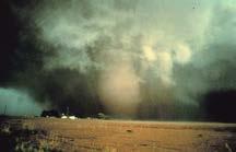
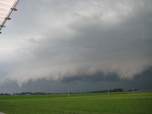
November 22, 1992, I-71, Carroll County KY by Irma Doran
|
|
|
- Harvey Charles
- 5 years ago
- Views:
Transcription

1 November 22, 1992, I-71, Carroll County KY by Irma Doran


2


3

4

5 The World s First Tornado Scientist

6 1885
7


8
9

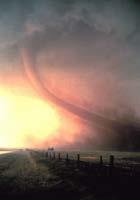
10 April 26, 1884 near Garnett, KS by A.A. Adams The World s First Tornado Photograph

11 August 28, 1884 Howard, Dakota Territory by F.N. Robinson The World s Second Tornado Photograph

12 1886 The word tornado is banned from forecasts to avoid panic.


13 Tinker AFB, Oklahoma March 20, 1948

14 Tinker AFB, Oklahoma March 25, 1948


15 Capt. Robt. C. Miller Lt. Col. E.J. Fawbush World s First Tornado Forecast

16 The World s First Recorded Hook Echo

17 Mr. Tornado, Dr. Ted Fujita

18 Sayler Park F5 Hook. At the time this was the most photographed tornado in the world.

19 Sayler Park F5 Before and while crossing the Ohio River. Photos by Andrew MacGregor

20 Sayler Park F5 Out of the river valley and crossing Cincinnati s western suburbs. Photos by Don Ohmer


21 Sayler Park F5 Out of the river valley and crossing Cincinnati s western suburbs. Photos by Jay Carter

22 The Bridge Creek Moore, OK tornado May 3, 1999 The last F5 under the original Fujita Scale. A Doppler on Wheels measured winds to 309 +/- 10 mph.


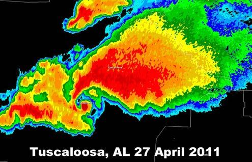
23 The Bridge Creek Moore, OK tornado May 3, F5 damage and the place where a woman died from being pummeled by debris.

24 Greensburg, KS EF5 tornado hook, Mar 4, 2007 The first tornado rated EF5 under the Enhanced Fujita Scale.

25 Greensburg, KS EF5 tornado, Mar 4, 2007 The first tornado rated EF5 under the Enhanced Fujita Scale.

26 Greensburg, KS EF5 tornado damage, Mar 4, 2007 The first tornado rated EF5 under the Enhanced Fujita Scale.

27 Greensburg, KS EF5 tornado hook, Mar 4, 2007 The first tornado rated EF5 under the Enhanced Fujita Scale.
28

29 Birmingham, AL

30 Tuscaloosa County, AL April 27, 2011 A wedge tornado

31 The path of the long-track supercell thunderstorm That produced the Tuscaloosa, AL EF4, 190 mph Path Length = 80.7 miles, maximum width 1.5 miles.

32 Joplin, MO EF5 hook echo, May 22, 2011.

33 Joplin, MO EF5 hook echo, May 22, 2011.

34 * Joplin, MO EF5 hook echo, May 22, 2011, Joplin, MO at the asterisk..

35 * Joplin, MO EF5 hook echo, May 22, 2011, Joplin, MO at the asterisk..

36 * Joplin, MO Debris Ball, May 22, 2011.

37 Joplin, MO Debris Ball, May 22, 2011.

38 Northern Kentucky, Suburban Cincinnati, Crittenden-Piner EF4, March 2, 2012

39 Velocity Couplet during spin up Crittenden-Piner EF4, March 2, 2012

40 Velocity Couplet at maximum intensity Crittenden-Piner EF4, March 2, 2012

41 Velocity Couplet when the tornado is lifting off Crittenden-Piner EF4, March 2, 2012

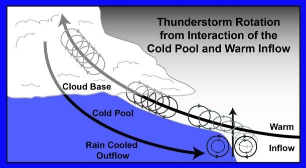
42 Velocity Couplet at tornado has dissipated Crittenden-Piner EF4, March 2, 2012
43

44
45
46
47 Velocity Couplet when the tornado is lifting off Crittenden-Piner EF4, March 2, 2012

48 > -80 kts > +80 kts Doppler radar only measures winds directly to and away from the radar Crittenden-Piner EF4, March 2, 2012

49 Rear Flank Downdraft, sinks behind the storm and the Warm air wraps around the tornado Crittenden-Piner EF4, March 2, 2012
50 Rear Flank Downdraft, sinks behind the storm and the Warm air wraps around the tornado Crittenden-Piner EF4, March 2, 2012
51 Rear Flank Downdraft, sinks behind the storm and the Warm air wraps around the tornado Crittenden-Piner EF4, March 2, 2012

52 Rear Flank Downdraft is visible as a bright area or a clear sky behind the storm. Crittenden-Piner EF4, March 2, 2012

53 Chaparral, NM Supercell, April 3, diameter hail

54

55
56
57

58
59

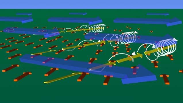
60

61
62

63 March 2, 2012, Berlin, KY EF0 - Reflectivity Leading Edge Vortices Gustnadoes Tornadoes without rotating supercell thunderstorms.

64 March 2, 2012, Berlin, KY EF0 Storm Relative Wind Leading Edge Vortices Gustnadoes Tornadoes without rotating supercell thunderstorms.


65 March 2, 2012, Berlin, KY EF0 Spectrum Width (turbulence) Leading Edge Vortices Gustnadoes Tornadoes without rotating supercell thunderstorms.
66
67 Rotating Supercell Thunderstorms 1. Favorable wind environment 2. Rotation generated outside the storm - Vertical Wind Shear - Cold Pool/Inflow Interaction 3. Rotation concentrated at the updraft 4. Rotation tilted to the vertical 5. Vortex Stretching rotation rate increases 6. Dynamic Pipe Effect Tornado descends to the ground 7. No DPE Tornado forms all levels quickly 8. Leading Edge Vortices Gustnadoes.

68
69
70
71 Finally. 1. We know When Tornadoes Form. 2. We Know Where Tornadoes Form. 3. We Know How Tornadoes Form. 4. We Know All Big Tornadoes are from Mesocyclones 5. We Know most small tornadoes are leading edge vortices, but some are from weak mesocyclones. 6. But Only 3% of Supercells Spawn Tornadoes 7. We cannot yet detect the final trigger.
Tornadoes. tornado: a violently rotating column of air
 Tornadoes tornado: a violently rotating column of air Tornadoes What is the typical size of a tornado? What are typical wind speeds for a tornado? Five-stage life cycle of a tornado Dust Swirl Stage Tornado
Tornado Occurrences. Tornadoes. Tornado Life Cycle 4/12/17
 Chapter 19 Tornadoes Tornado Violently rotating column of air that extends from the base of a thunderstorm to the ground Tornado Statistics Over (100, 1000, 10000) tornadoes reported in the U.S. every
Severe Thunderstorms
 Lecture 26 Severe Thunderstorms NWS Criteria Environment Structure Climatology 1 Severe Thunderstorms NWS Criteria Environment Structure Climatology 2 Severe Thunderstorms: NWS Criteria NWS Criteria: to
Tornadoes forecasting, dynamics and genesis. Mteor 417 Iowa State University Week 12 Bill Gallus
 Tornadoes forecasting, dynamics and genesis Mteor 417 Iowa State University Week 12 Bill Gallus Tools to diagnose severe weather risks Definition of tornado: A vortex (rapidly rotating column of air) associated
Tornadogenesis in Supercells: The Three Main Ingredients. Ted Funk
 Tornadogenesis in Supercells: The Three Main Ingredients Ted Funk NWS Louisville, KY Spring 2002 Environmental Parameters Supercells occur within environments exhibiting several wellknown characteristics
MET Lecture 26 Tornadoes I
 MET 4300 Lecture 26 Tornadoes I A Large Tornado approaches Lyndon, Kansas, on May 8, 2003 Outline Definition, life cycle Tornado formation within supercells Tornado formation within nonsupercell thunderstorms
Tornadoes forecasting, dynamics and genesis. Mteor 417 Iowa State University Week 12 Bill Gallus
 Tornadoes forecasting, dynamics and genesis Mteor 417 Iowa State University Week 12 Bill Gallus Tools to diagnose severe weather risks Definition of tornado: A vortex (rapidly rotating column of air) associated
1st Tornado Photograph
 Lecture 26 Part II Tornados Environment Storm Structure Life Cycle Source of Spin Forecasting Climatology Damage Marilee Thomas of Beaver City, NE took this photograph of her daughter Audra about two miles
NOAA S National Weather Service
 NOAA S National Weather Service Elite Concepts of Severe Storm Spotting 2011 Rusty Kapela Milwaukee/Sullivan www.weather.gov/mkx Elite Spotter Outline Review Types of T storms Tornadic Supercell Classic,
May 16, 2009 (Part II) - A Mesoscale and Radar Perspective of the Tornadic Supercells. Michael L. Jurewicz, Sr. WFO BGM
 - A Mesoscale and Radar Perspective of the Tornadic Supercells. Michael L. Jurewicz, Sr. WFO BGM") May 16, 2009 (Part II) - A Mesoscale and Radar Perspective of the Tornadic Supercells Michael L. Jurewicz, Sr. WFO BGM Mesoscale Boundary Assistance A pre-frontal trough formed across Western NY / PA early
May 16, 2009 (Part II) - A Mesoscale and Radar Perspective of the Tornadic Supercells Michael L. Jurewicz, Sr. WFO BGM Mesoscale Boundary Assistance A pre-frontal trough formed across Western NY / PA early
10/21/2012. Chapter 10 Thunderstorms. Part II. Growth and Development of ordinary Cell Thunderstorms Thunderstorm Electrification.
 Chapter 10 Thunderstorms Part I Growth and Development of ordinary Cell Thunderstorms Thunderstorm Electrification Tornadoes Part II Simplified model depicting the life cycle of an ordinary thunderstorm
Severe Thunderstorms. MET 200 Lecture 24 Flooding in Hawaii and Intro to Severe Thunderstorms. MET 200 Lecture 24 Severe Thunderstorms.
 MET 200 Lecture 24 Severe Thunderstorms Damage Swath 1 2 MET 200 Lecture 24 Flooding in Hawaii and Intro to Severe Thunderstorms Severe Thunderstorms Kona Lows Cause more flash floods in Hawaii than any
MET Lecture 29 Tornadoes IV
 MET 4300 Lecture 29 Tornadoes IV Outline Definition, life cycle, & climatology of tornadoes Tornado formation within supercells Tornado formation within nonsupercell thunderstorms Fujita scale Tornado
Review of Basic Severe Thunderstorm & Tornado Spotting Concepts. Jim Allsopp National Weather Service Chicago/Romeoville, IL
 Review of Basic Severe Thunderstorm & Tornado Spotting Concepts Jim Allsopp National Weather Service Chicago/Romeoville, IL Why Do We Need Spotters? Radar has limitations, only spotters can provide view
Chapter 3 Convective Dynamics Part VI. Supercell Storms. Supercell Photos
 Chapter 3 Convective Dynamics Part VI. Supercell Storms Photographs Todd Lindley (This part contains materials taken from UCAR MCS training module) Supercell Photos 1 Introduction A supercel storm is defined
Test Form: A Key Final Exam: Spring 2011
 Test Form: A Key Final Exam: Spring 2011 Instructions: Write your name (last name and first name) on your bubble sheet. Write your student identification number on the bubble sheet, and carefully and completely
Tornadoes. Tornadoes. When do tornadoes occur? Tornado Alley
 Tornadoes Tornadoes Dr. Christopher M. Godfrey University of North Carolina at Asheville Photo: D. Zaras, NOAA A tornado is a violently rotating column of air in contact with the ground Tornadogenesis
Tornado Structure and Risk. Center for Severe Weather Research. The DOW Perspective
 Photo by Herb Stein Tornado Structure and Risk Center for Severe Weather Research The DOW Perspective Photo by Herb Stein Stationary Radars are too far away to resolve tornado structure Blurry Image By
Meteorology Lecture 19
 Meteorology Lecture 19 Robert Fovell rfovell@albany.edu 1 Important notes These slides show some figures and videos prepared by Robert G. Fovell (RGF) for his Meteorology course, published by The Great
Thunderstorm: a cumulonimbus cloud or collection of cumulonimbus clouds featuring vigorous updrafts, precipitation and lightning
 Thunderstorm: a cumulonimbus cloud or collection of cumulonimbus clouds featuring vigorous updrafts, precipitation and lightning Thunderstorm: a cumulonimbus cloud or collection of cumulonimbus clouds
MET Lecture 34 Downbursts
 MET 4300 Lecture 34 Downbursts Downbursts A strong downdraft that originates within the lower part of a cumulus cloud or thunderstorms and spreads out at the surface Downbursts do not require strong thunderstorms
Tornadoes. A. T. Willett/The Image Bank/Getty Images
 Tornadoes A. T. Willett/The Image Bank/Getty Images Created by Chelsea Austin Introduction to Physical Science, EMPACTS Project, Fall 2012 How are Tornadoes related to Hurricanes? Tornadoes are spawned
Final Exam Clicker Questions ATOC 1050 Spring 2011 Chapter 16: Mountain Snowstorms
 Final Exam Clicker Questions ATOC 1050 Spring 2011 Chapter 16: Mountain Snowstorms True or false: Mean annual snowfall in the western United States always increases from south to north. Total precipitation
Thunderstorm. Thunderstorms result from the rapid upward movement of warm, moist air.
 Severe Weather Thunderstorm A thunderstorm (aka an electrical storm, a lightning storm, or a thundershower) is a type of storm characterized by the presence of lightning and its acoustic effect, thunder.
NOAA S National Weather Service
 NOAA S National Weather Service Night Spotting Advanced Concepts of Severe Storm Spotting 2012 Rusty Kapela Milwaukee/Sullivan Weather.gov/milwaukee Problems Spotters Encounter Spotters can only see a
The Severe Weather Event of 7 August 2013 By Richard H. Grumm and Bruce Budd National Weather Service State College, PA 1. INTRODUCTION and Overview
 The Severe Weather Event of 7 August 2013 By Richard H. Grumm and Bruce Budd National Weather Service State College, PA 1. INTRODUCTION and Overview A fast moving short-wave (Fig. 1) with -1σ 500 hpa height
Mature Tornado. Tornado funnel and debris cloud. Mature Tornado
 Mature Tornado Tornado funnel and debris cloud 43 Mature Tornado 44 Tornado in Final Rope Stage 45 Source of Spin 46 Source of Spin Updraft Stretches Rotating Column 47 Simulation of Tornado Formation
THUNDERSTORMS. Convective heavy rain accompanied by lightning and thunder. Ahrens
 THUNDERSTORMS Convective heavy rain accompanied by lightning and thunder Ahrens Thunderstorms About 1,800 T-storms occur around the world at any instant Where do they occur the most? National Lightning
Thunderstorms. Ordinary Cell Thunderstorms. Ordinary Cell Thunderstorms. Ordinary Cell Thunderstorms 5/2/11
 A storm containing lightning and thunder; convective storms Chapter 14 Severe thunderstorms: At least one: large hail wind gusts greater than or equal to 50 kt Tornado 1 2 Ordinary Cell Ordinary Cell AKA
Thunderstorm: a cumulonimbus cloud or collection of cumulonimbus clouds featuring vigorous updrafts, precipitation and lightning
 Thunderstorm: a cumulonimbus cloud or collection of cumulonimbus clouds featuring vigorous updrafts, precipitation and lightning Thunderstorms are responsible for most of what we refer to as severe weather,
The Earth System - Atmosphere III Convection
 The Earth System - Atmosphere III Convection Thunderstorms 1. A thunderstorm is a storm that produces lightning (and therefore thunder) 2. Thunderstorms frequently produce gusty winds, heavy rain, and
Severe Thunderstorm Forecasting and Climatology in Arizona. Ken Drozd Warning Coordination Meteorologist NOAA/NWS Tucson, AZ
 Severe Thunderstorm Forecasting and Climatology in Arizona Ken Drozd Warning Coordination Meteorologist NOAA/NWS Tucson, AZ THUNDERSTORM FORMATION All thunderstorms result from the same necessary conditions
Tornadoes. Tornadoes. When do tornadoes occur? Tornado Alley
 Tornadoes Tornadoes Dr. Christopher M. Godfrey University of North Carolina at Asheville Photo: D. Zaras, NOAA A tornado is a violently rotating column of air in contact with the ground Tornadogenesis
Weather Systems III: Thunderstorms and Twisters
 Weather Systems III: Thunderstorms and Twisters Review 1. Definition of airmasses? Bergeron classification of air masses 2. Surface weather analysis: Station model, wind speed code, present weather 3.
15.3A TORNADO VISUALIZATION AND DOPPLER RADAR ANALYSIS PROJECT. Thomas Dolan * Independent Geographer, Rocklin, CA
 15.3A TORNADO VISUALIZATION AND DOPPLER RADAR ANALYSIS PROJECT Thomas Dolan * Independent Geographer, Rocklin, CA 1. INTRODUCTION Tornadoes play a significant role in the weather of the United States and
Recent observations of tornadoes using a mobile, rapid-scan, polarimetric, X-band, Doppler radar
 Recent observations of tornadoes using a mobile, rapid-scan, polarimetric, X-band, Doppler radar Howard B. Bluestein 1, Jeffrey C. Snyder 2, Kyle J. Thiem 1, Zachary B. Wienhoff 1, Jana B. Houser 3, and
Tornado Dynamics. Readings:
 Tornado Dynamics Readings: Klemp (1987) Dynamics of Tornadic Thunderstorms (handout) Bluestein Vol II. Section 3.4.8. Rotunno, R., 1986: Tornadoes and tornadogenesis. In: P. Ray (Editor), Mesoscale Meteorology
Chapter 14 Thunderstorm Fundamentals
 Chapter overview: Thunderstorm appearance Thunderstorm cells and evolution Thunderstorm types and organization o Single cell thunderstorms o Multicell thunderstorms o Orographic thunderstorms o Severe
CLOUDS & THUNDERSTORMS
 Funding provided by NOAA Sectoral Applications Research Project CLOUDS & THUNDERSTORMS Basic Climatology Oklahoma Climatological Survey How are clouds made? Clouds form when air is cooled to its dewpoint
Practical Use of the Skew-T, log-p diagram for weather forecasting. Primer on organized convection
 Practical Use of the Skew-T, log-p diagram for weather forecasting Primer on organized convection Outline Rationale and format of the skew-t, log-p diagram Some basic derived diagnostic measures Characterizing
Tornadoes. Be able to define what a tornado is. Be able to list several facts about tornadoes.
 Tornadoes Be able to define what a tornado is. Be able to list several facts about tornadoes. 1. Where do tornadoes most U.S. is # 1 occur in the world? Tornadoes are most common in Tornado Alley. Tornado
Mid Atlantic Severe Event of 1 May 2017 Central Pennsylvania QLCS event By Richard H. Grumm National Weather Service, State College, PA 16803
 1. Overview Mid Atlantic Severe Event of 1 May 2017 Central Pennsylvania QLCS event By Richard H. Grumm National Weather Service, State College, PA 16803 A strong upper-level wave (Fig.1) moving into a
13.5 DOPPLER RADAR ANALYSIS OF THE 28 APRIL 2002 LA PLATA, MD TORNADIC SUPERCELL
 13.5 DOPPLER RADAR ANALYSIS OF THE 28 APRIL 2002 LA PLATA, MD TORNADIC SUPERCELL David R. Manning* and Steven M. Zubrick NOAA/National Weather Service, Sterling, Virginia 1. Introduction A severe weather
Module 11: Meteorology Topic 6 Content: Severe Weather Notes
 Severe weather can pose a risk to you and your property. Meteorologists monitor extreme weather to inform the public about dangerous atmospheric conditions. Thunderstorms, hurricanes, and tornadoes are
P15.13 DETECTION OF HAZARDOUS WEATHER PHENOMENA USING DATA ASSIMILATION TECHNIQUES
 P15.13 DETECTION OF HAZARDOUS WEATHER PHENOMENA USING DATA ASSIMILATION TECHNIQUES 1. INTRODUCTION Robert Fritchie*, Kelvin Droegemeier, Ming Xue, Mingjing Tong, Elaine Godfrey School of Meteorology and
Numerical Prediction of 8 May 2003 Oklahoma City Supercell Tornado with ARPS and Radar Data Assimilation
 1 2 3 4 5 6 7 8 9 10 11 12 13 14 15 16 17 18 19 20 21 22 23 24 25 26 27 28 29 30 31 32 33 34 35 36 37 38 39 Numerical Prediction of 8 May 2003 Oklahoma City Supercell Tornado with ARPS and Radar Data Assimilation
Chapter 3 Convective Dynamics 3.4. Bright Bands, Bow Echoes and Mesoscale Convective Complexes
 Chapter 3 Convective Dynamics 3.4. Bright Bands, Bow Echoes and Mesoscale Convective Complexes Photographs Todd Lindley Bright band associated with stratiform precipitation in a squall line system 1 Bright
CHAPTER 11 THUNDERSTORMS AND TORNADOES MULTIPLE CHOICE QUESTIONS
 CHAPTER 11 THUNDERSTORMS AND TORNADOES MULTIPLE CHOICE QUESTIONS 1. A thunderstorm is considered to be a weather system. a. synoptic-scale b. micro-scale c. meso-scale 2. By convention, the mature stage
III. Section 3.3 Vertical air motion can cause severe storms
 III. Section 3.3 Vertical air motion can cause severe storms http://www.youtube.com/watch?v=nxwbr60tflg&feature=relmfu A. Thunderstorms form from rising moist air Electrical charges build up near the tops
P10.18 ORIGINS OF THE GRANITE FALLS, MN TORNADO, JULY 25, 2000 REVISITED
 P10.18 ORIGINS OF THE GRANITE FALLS, MN TORNADO, JULY 25, 2000 REVISITED Doug Dokken, Rich Naistat, Bill Togstad, and Kurt Scholz. Keenan Weise, John Nelson, Luke Edholm, and Pat Shanahan. 1. INTRODUCTION
Storm Hazards covered in this course
 Chasing Tornadoes (LG: 3a) A video Teaser, while students enter the classroom. Day3-60 Tornadoes of 2016 (16:05) Pecos Hank channel https://www.youtube.com/watch?v=nzmtglwx0n4 Watch on your own: 2016 and
Solutions to Comprehensive Final Examination Given on Thursday, 13 December 2001
 Name & Signature Dr. Droegemeier Student ID Meteorology 1004 Introduction to Meteorology Fall, 2001 Solutions to Comprehensive Final Examination Given on Thursday, 13 December 2001 BEFORE YOU BEGIN!! Please
TOPICS: What are Thunderstorms? Ingredients Stages Types Lightning Downburst and Microburst
 THUNDERSTORMS TOPICS: What are Thunderstorms? Ingredients Stages Types Lightning Downburst and Microburst What are Thunderstorms? A storm produced by a cumulonimbus cloud that contains lightning and thunder
Meteorology Lecture 18
 Meteorology Lecture 18 Robert Fovell rfovell@albany.edu 1 Important notes These slides show some figures and videos prepared by Robert G. Fovell (RGF) for his Meteorology course, published by The Great
HAZARDOUS WEATHER 1. Dr. Julie Laity Geography 266
 HAZARDOUS WEATHER 1 Dr. Julie Laity Geography 266 Violent Weather Thunderstorms Atmospheric turbulence Lightning and thunder Hail Derechos Tornadoes Tornado measurement and science Tropical Cyclones Hurricanes
Examination #3 Wednesday, 28 November 2001
 Name & Signature Dr. Droegemeier Student ID Meteorology 1004 Introduction to Meteorology Fall, 2001 Examination #3 Wednesday, 28 November 2001 BEFORE YOU BEGIN!! Please be sure to read each question CAREFULLY
Weather Systems. The air around high-pressure weather systems tends to swirl in a clockwise direction, and usually brings clear skies.
 Weather Systems A weather system is a set of temperature, wind, pressure, and moisture conditions for a certain region that moves as a unit for a period of several days. Low-pressure weather systems form
June 7, 2008 Northeast Illinois Tornado Outbreak: Applying to Fundamentals in Storm Spotting
 June 7, 2008 Northeast Illinois Tornado Outbreak: Applying to Fundamentals in Storm Spotting Near Manhattan, IL Richton Park, IL Ricky Castro National Weather Service Chicago/Romeoville, IL Tornado Crossing
Our Challenge. It s All Wind 2/16/2017
 2/16/2017 It s All Wind Communicating Damaging Wind & Tornado Threats in an Impact-based Environment Rick Smith - NWS Norman, OK Justin Dougherty Our Challenge Given the history and types of weather threats
Thunderstorms and Tornadoes. Chapter 14
 Thunderstorms and Tornadoes Chapter 14 Thunderstorms A storm containing lightning and thunder convective storms Severe thunderstorms (NWS def) one of following: large hail - ¾ in dia Surface wind gusts
The Greensburg, KS Tornado
 J2.4 The Greensburg, KS Tornado Daniel McCarthy NOAA Storm Prediction Center Norman, OK Larry Ruthi and Jeff Hutton NWS Weather Forecast Office Dodge City, KS 1. Background The tornado that moved through
Supercells. Base lecture and Graphics created by The COMET Program May University Corporation for Atmospheric Research
 Supercells Base lecture and Graphics created by The COMET Program May 2002 University Corporation for Atmospheric Research Objective To be able to forecast and better recognize supercell storms in all
Foundations of Earth Science, 6e Lutgens, Tarbuck, & Tasa
 Foundations of Earth Science, 6e Lutgens, Tarbuck, & Tasa Weather Patterns and Severe Weather Foundations, 6e - Chapter 14 Stan Hatfield Southwestern Illinois College Air masses Characteristics Large body
UNDERSTANDING TORNADOES! A guide about their causes, prediction, and how to stay safe when they threaten.
 UNDERSTANDING TORNADOES! A guide about their causes, prediction, and how to stay safe when they threaten. Evolution of tornado forecasting in the U. S. Perhaps the most awesome spectacles yet most dangerous
A Detailed Analysis of a Long-Tracked Supercell. Jason T. Martinelli and Andrew Elliott. Fred Glass
 A Detailed Analysis of a Long-Tracked Supercell Jason T. Martinelli and Andrew Elliott Department of Atmospheric Sciences, Creighton University, Omaha, Nebraska Fred Glass National Weather Service Forecast
Thunderstorms and Severe Weather. (Chapt 15)
") Thunderstorms and Severe Weather (Chapt 15) The Big Picture We ve emphasized horizontal transport of energy to balance the planetary energy budget: Hadley Cell Subtropical divergence Midlatitude cyclones
Thunderstorms and Severe Weather (Chapt 15) The Big Picture We ve emphasized horizontal transport of energy to balance the planetary energy budget: Hadley Cell Subtropical divergence Midlatitude cyclones
P12.7 MESOCYCLONE AND RFD INDUCED DAMAGING WINDS OBSERVED IN THE 27 MAY 2004 SOUTHWEST OHIO SUPERCELL
 P12.7 MESOCYCLONE AND RFD INDUCED DAMAGING WINDS OBSERVED IN THE 27 MAY 2004 SOUTHWEST OHIO SUPERCELL John T. DiStefano* National Weather Service Office, Wilmington, Ohio 1. INTRODUCTION During the early
Announcements. No office hours tomorrow (Wed. March 30) Homework 5 extra credit:
 Homework 5 extra credit:") Announcements No office hours tomorrow (Wed. March 30) Homework 5 extra credit: Find and plot additional tracks of Hurricane Ivan (after reaching its northeastmost point in U.S) North Dakota Lightning
Announcements No office hours tomorrow (Wed. March 30) Homework 5 extra credit: Find and plot additional tracks of Hurricane Ivan (after reaching its northeastmost point in U.S) North Dakota Lightning
16 September 2005 Northern Pennsylvania Supercell Thunderstorm by Richard H. Grumm National Weather Service Office State College, PA 16803
 16 September 2005 Northern Pennsylvania Supercell Thunderstorm by Richard H. Grumm National Weather Service Office State College, PA 16803 1. INTRODUCTION During the afternoon hours of 16 September 2005,
4/18/2010. National Weather Service. Severe Weather Forecasting: A Western North Carolina Case Study
 National Weather Service Severe Weather Forecasting: A Western North Carolina Case Study Laurence G. Lee Science and Operations Officer National Weather Service Greer, SC Plus 13 River Forecast Centers
P8.10 AN EXAMINATION OF VARYING SUPERCELL ENVIRONMENTS OVER THE COMPLEX TERRAIN OF THE EASTERN TENNESSEE RIVER VALLEY
 P8.10 AN EXAMINATION OF VARYING SUPERCELL ENVIRONMENTS OVER THE COMPLEX TERRAIN OF THE EASTERN TENNESSEE RIVER VALLEY by David M. Gaffin* and David G. Hotz National Weather Service, Morristown TN 1. INTRODUCTION
ATS 351, Spring 2010 Lab #11 Severe Weather 54 points
 ATS 351, Spring 2010 Lab #11 Severe Weather 54 points Question 1 (10 points): Thunderstorm development a) Sketch and describe the stages of development of a single cell thunderstorm. About how long does
Curious Dragonfly Monthly Science Newsletter
 Curious Dragonfly Monthly Science Newsletter Tornadoes! THE EYE OF THE STORM We've all seen them. Whether we were safely in the confines of our house, seeing them on television, or confronted with them
P10.4 EXAMINATION OF TORNADIC AND NON-TORNADIC SUPERCELLS IN SOUTHWEST VIRGINIA ON 28 APRIL 2002
 P10.4 EXAMINATION OF TORNADIC AND NON-TORNADIC SUPERCELLS IN SOUTHWEST VIRGINIA ON 28 APRIL 2002 Steve Keighton*, Kenneth Kostura, and Chris Liscinsky NOAA/National Weather Service Blacksburg, VA 1. INTRODUCTION
Advanced Spotter Training Lesson 4: The Nature of Thunderstorms
 Advanced Spotter Training 2009 Lesson 4: The Nature of Thunderstorms From Last Time We discussed the different ways to make air rise. We discussed convection, convergence, and the different kinds of fronts.
ATMO Exam 3 Spring Print your name ID Number
 ATMO 336-002 Exam 3 Spring 2008 Print your name ID Number Note: In multiple choice questions, more than one answer may be valid. Please check all valid answers. It is OK to use a hand calculator on this
P PRELIMINARY ANALYSIS OF THE 10 JUNE 2010 SUPERCELLS INTERCEPTED BY VORTEX2 NEAR LAST CHANCE, COLORADO
 P12.164 PRELIMINARY ANALYSIS OF THE 10 JUNE 2010 SUPERCELLS INTERCEPTED BY VORTEX2 NEAR LAST CHANCE, COLORADO 1. INTRODUCTION An outstanding question in the field of severe storms research is why some
Kristy Stolz, Savanna Hawkins, Myka Lyles, Heather Gabriele
 Kristy Stolz, Savanna Hawkins, Myka Lyles, Heather Gabriele Tornadoes are violent winds that rotate from a super cell down to the ground. They rotate counterclockwise in the northern hemisphere and clockwise
contact with ground for 1 hour plus, starting 1500 MDT moved N., covered about 37 km width varied m
 Goal for today: Finish Ch. 11 Lightning, Thunder & Tornadoes 16 Nov., 2011 Edmonton tornado 31 July 1987 contact with ground for 1 hour plus, starting 1500 MDT moved N., covered about 37 km width varied
12.2 MESOVORTICES FORMED WITHIN BOW ECHOES: THEIR GENESIS AND SENSITIVITY TO THE ENVIRONMENT AND SYSTEM COLD POOL
 12.2 MESOVORTICES FORMED WITHIN BOW ECHOES: THEIR GENESIS AND SENSITIVITY TO THE ENVIRONMENT AND SYSTEM COLD POOL Nolan T. Atkins and Mike St. Laurent Lyndon State College, Lyndonville, Vermont 1. INTRODUCTION
Genesis mechanism and structure of a supercell tornado in a fine-resolution numerical simulation
 Genesis mechanism and structure of a supercell tornado in a fine-resolution numerical simulation Akira T. Noda a, Hiroshi Niino b a Ocean Research Institute, The University of Tokyo, 1-15-1 Minamidai,
Severe Weather Event of 13 July 2014
 Severe Weather Event of 13 July 2014 By Richard H. Grumm and Elyse M. Colbert National Weather Service State College, PA 1. Overview Severe weather affected the eastern United States (Fig. 1) from northwestern
Using UAS Technology to Obtain Aerial Storm Damage Imagery. -Mike Sporer NWS Blacksburg
 Using UAS Technology to Obtain Aerial Storm Damage Imagery -Mike Sporer NWS Blacksburg The National Weather Service routinely conducts damage surveys following severe weather events. Observed damage indicators
Your Task: Read each slide then use the underlined red or underlined information to fill in your organizer.
 Severe Weather: Tornadoes and Hurricanes Thunderstorms and Lightning S6E4 d. Construct an explanation of the relationship between air pressure, weather fronts, and air masses and meteorological events
P10.2 SUBTLE RADAR SIGNATURES IN THE WEST BROOKFIELD, MA TORNADO OF 23 JULY 2002
 P10.2 SUBTLE RADAR SIGNATURES IN THE WEST BROOKFIELD, MA TORNADO OF 23 JULY 2002 Glenn A. Field and David R. Vallee NOAA/National Weather Service Forecast Office, Taunton, MA 1. INTRODUCTION Tornadic storms
24 TH CONFERENCE ON SEVERE LOCAL STORMS, OCTOBER 2008, SAVANNAH, GEORGIA
 P9.13 SUPER-RESOLUTION POLARIMETRIC OBSERVATIONS OF A CYCLIC TORNADIC SUPERCELL MATTHEW R. KUMJIAN*, ALEXANDER V. RYZHKOV, AND VALERY M. MELNIKOV Cooperative Institute for Mesoscale Meteorological Studies,
Storms. Tropical Cyclone?
 Storms Tropical Cyclone? Tropical Cyclone: low pressure storm forming in the tropics (Start as Thunder Storms). They form around a center, producing heavy winds and rains. Storms What strengthens a Tropical
VORTEX-2: SUNY Oswego Soundings Team Significant Observed Weather Events Kevin M. Smith
 VORTEX-2: SUNY Oswego Soundings Team Significant Observed Weather Events Kevin M. Smith Summary Last Updated: Final Update The following is a chronological listing of significant weather conditions observed
An Unprecedented Wisconsin Tornado Outbreak on 18 August 2005
 An Unprecedented Wisconsin Tornado Outbreak on 18 August 2005 Zachary P. Uttech Department of Atmospheric and Oceanic Sciences University of Wisconsin-Madison May 5, 2009 ABSTRACT On 18 August 2005, a
Ch. 3: Weather Patterns. Sect. 1: Air Mass & Fronts Sect. 2: Storms Sect. 3: Predicting the Weather
 Ch. 3: Weather Patterns Sect. 1: Air Mass & Fronts Sect. 2: Storms Sect. 3: Predicting the Weather Sect. 1: Air Masses & Fronts An air mass is a huge body of air that has similar temperature, humidity,
Pennsylvania Severe Weather of September 2016
 Pennsylvania Severe Weather of September 2016 By Richard H. Grumm National Weather Service State College, PA 1. Overview September 2016 was a relatively quiet month for severe weather across most of the
An Observational Analysis of Potential Terrain Influences on Tornado Behavior
 An Observational Analysis of Potential Terrain Influences on Tornado Behavior Anthony W. Lyza and Kevin R. Knupp Severe Weather Institute and Radar & Lightning Laboratories (SWIRLL) The University of Alabama
P10.1 TORNADOGENESIS IN A SIMULATED HP SUPERCELL
 Preprints, 21 st Conference on Severe Local Storms 12-16 August 2002, San Antonio, Texas P10.1 TORNADOGENESIS IN A SIMULATED HP SUPERCELL 1. INTRODUCTION Catherine A. Finley * Department of Earth Sciences
Chap 14: Thunderstorms & Tornadoes
 Chap 14: Thunderstorms & Tornadoes Ordinary thunderstorms Severe thunderstorms Microburst Mesoscale convective systems Squall line Mesoscale convective complex Multicell thunderstorms move to right of
P2.5 THE TORNADO OUTBREAK OF 1-2 MARCH 2007 IN THE NATIONAL WEATHER SERVICE TALLAHASSEE FORECAST AREA
 P2.5 THE TORNADO OUTBREAK OF 1-2 MARCH 2007 IN THE NATIONAL WEATHER SERVICE TALLAHASSEE FORECAST AREA Andrew I. Watson* Bryan A. Mroczka J. Parks Camp Jeffery A. Fournier Robert C. Goree NOAA/National
P8.14 CLASSIC AND HP MINI-SUPERCELLS IN SOUTHEAST OREGON AND SOUTHWEST IDAHO ON 3 MAY
 P8.14 CLASSIC AND HP MINI-SUPERCELLS IN SOUTHEAST OREGON AND SOUTHWEST IDAHO ON 3 MAY 2009 Stephen S. Parker* National Weather Service, Boise, ID 1. INTRODUCTION During the early afternoon hours of 3 May
The Oakfield, Wisconsin, Tornado from July Brett Berenz Student at the University of Wisconsin
 The Oakfield, Wisconsin, Tornado from 18-19 July 1996 Brett Berenz Student at the University of Wisconsin Abstract On July 18 th, 1996 an F5 tornado affected the region of Oakfield, Wisconsin. Leading
P3.17 THE DEVELOPMENT OF MULTIPLE LOW-LEVEL MESOCYCLONES WITHIN A SUPERCELL. Joshua M. Boustead *1 NOAA/NWS Weather Forecast Office, Topeka, KS
 P3.17 THE DEVELOPMENT OF MULTIPLE LOW-LEVEL MESOCYCLONES WITHIN A SUPERCELL Joshua M. Boustead *1 NOAA/NWS Weather Forecast Office, Topeka, KS Philip N. Schumacher NOAA/NWS Weather Forecaster Office, Sioux
WISCONSIN TORNADO OUTBREAK OF 18 AUGUST 2005: AN EXAMINATION OF THE VIOLA, WISCONSIN TORNADO
 WISCONSIN TORNADO OUTBREAK OF 18 AUGUST 2005: AN EXAMINATION OF THE VIOLA, WISCONSIN TORNADO Charles D. Koch University of Wisconsin Madison AOS 453: Mesoscale Meteorology Professor Greg Tripoli 13 May
Debris Balls As Tornado Indicators in Spring Dr. Greg Forbes Severe Weather Expert The Weather Channel Atlanta, GA
 Debris Balls As Tornado Indicators in Spring 2011 Dr. Greg Forbes Severe Weather Expert The Weather Channel Atlanta, GA Radar Debris Balls * What Do They Tell Us? What constitutes a reliable tornado debris