NOAA S National Weather Service
|
|
|
- Alvin Vincent Walton
- 5 years ago
- Views:
Transcription

1 NOAA S National Weather Service Elite Concepts of Severe Storm Spotting 2011 Rusty Kapela Milwaukee/Sullivan
2 Elite Spotter Outline Review Types of T storms Tornadic Supercell Classic, LP & HP Supercell Wedge vs Rope Tornado Rain wrapped Tornadoes Mesocyclone RFD & Tornadogenesis


")


3 Types of Thunderstorms Weak updraft (non-severe or severe) Moderate updraft (nonsevere or severe) Moderate updraft (nonsevere or severe) Intense updraft (Always severe) Mesocyclone - Rotating updraft Slight threat Moderate threat Moderate threat High threat Squall Line

4

5 Cyclic Supercell
6 Cyclic Supercell The original updraft tower and associated tornado eventually become occluded as they are cut off from their warm, moist air supply (tornado falls apart spins down). Meanwhile, a new updraft tower and mesocyclone develop downstream to the east-northeast (assuming storm moving to the northeast), and eventually a new tornado spins up. Process can repeat itself 3 to 6 times
7 Cyclic Tornadogenesis Burgess et al. 1982
 Rating: EF5 Duration: 65 min. Length: 28.8 mi Mean Width: 1.1 mi Max Width: 1.")
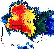
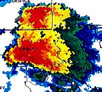
8 Greensburg Cyclic Supercell Rating: EF3 (strong) Duration: 65 min. Length: 23.5 mi Mean Width: 1.5 mi Max Width: 2.2 mi Damage Area: 35.4 mi 2 (A5) Damage $$: 1.5 M Trousdale Macksville Hopewell St. John Rating: EF3 Duration: 24 min. Length: 17.4 mi Mean Width: 0.6 mi Max Width: 0.9 mi Damage Area: 9.7 mi 2 (A4) Rating: EF5 Duration: 65 min. Length: 28.8 mi Mean Width: 1.1 mi Max Width: 1.7 mi* Damage Area: 32.9 mi 2 (A5) 1 Fatalities: 11 Damage $$: 250 M Greensburg Haviland Rating: EF3 (strong) Duration: 58 min. Length: 18.2 mi Mean Width: 0.9 mi Max Width: 1.2 mi Damage Area: 15.6 mi 2 (A4) Fatalities: 1 Fatalities: 1 May 4, 2007


9 NSSL Supercell Model Warm Moist Air
10 Rear Flank Downdraft Crucial to tornado development Downdraft on backside of updraft tower Wraps around updraft to tighten low-level circulation RFD UPDRAFT T DOWNDRAFT N (Top view)


11 HP Supercell HP Supercell N Light Rain Looking west Heavy Rain Updraft Anvil Edge Top view Generally, there is not a good spot to view this type of storm since it is wrapped by a rain shield.

12 HP Supercell RFD FFD Copyright Jon Davies Embedded Tornado

13 HP Supercell (Hidden Tornado)

14 LP Supercell Light Rain Possible Hail

15 LP Supercell

16 Horizontal Rotation Becoming Veritcal Rotation Trick is to get any horizontal vorticity or rotation tilted and stretched into updraft to sustain mesocyclone and rotation at base of storm

17 Mesocyclone Mesocyclone gets energy from vertical wind shear concentrated in the lowest 10-15,000 feet of the atmosphere


18 Mesocyclone Rotating updraft within the Rain- Free Cloud Base Present with all Supercells! Research suggests no more than 10% of radar detected mesocyclones are associated with tornadoes


19 Rear Flank Downdraft RFD Photo by Michael Peregrine Wall Cloud

20 Rear Flank Downdraft

21 Rear Flank Downdraft Winds Scott Weberpal Kinsley, KS June 15, 2009 No tornado, dust/dirt appears to be lifted to cloud base by RFD Video
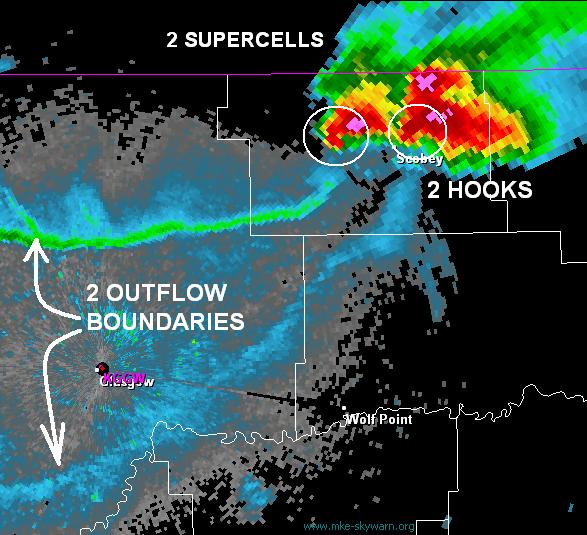
22 Understanding Tornadogenesis In order to generate a tornado, a storm needs four basic things 1. Time it must persist for an appreciable time (long-lived updraft that doesn t get choked by downdraft). Vertical wind shear (stronger winds aloft) pushes (tilts) the updraft over. 2. Most of wind shear needs to be concentrated in the lowest 10-thsd feet of the atmosphere rotation results (mesocyclone).
 needs to generate a low-level boundary on it s south side which then allows for local generation of horizontal vorticity (rotation) that can be tilted and stretched")
23 Understanding Tornadogenesis And 3. Forward Flank Downdraft (FFD) needs to generate a low-level boundary on it s south side which then allows for local generation of horizontal vorticity (rotation) that can be tilted and stretched vertically in the updraft area of the storm 4. Rear Flank Downdraft needs to curl around the rotating wall cloud and transfer torque a preexisting, broad rotation below cloud base, and it needs to have sufficient buoyancy (not too cool) so part of it can take another ride up into the updraft.

24

25 Radar Interpretation Beam is 5 thsd feet AGL Beam is 17 thsd feet AGL

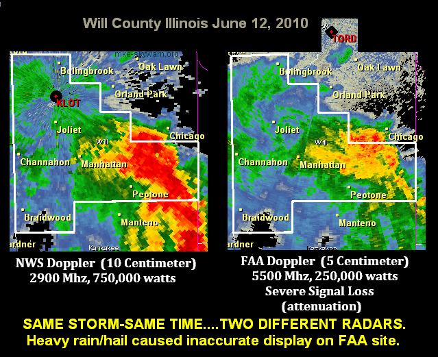
26 Base Versus Composite

27 Classic Supercell X X Storm Relative Radar site Radar site


28 Storm Splitting


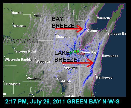
29 Cell Merger Outflow Lake Breeze


30 Line Echo Wave Pattern Meso Low

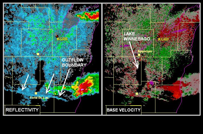
31 Outflow Boundaries Outflow Boundary Squall Line


32 Outflow Boundaries Triple Point Short bowing segment?
33
34
35

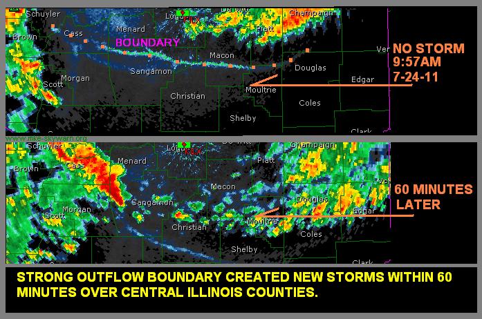
36 Storm Intensification * Watch for storm buildups along outflow boundaries when they plow into humid air. * If two outflow boundaries approach from different directions, when they intersect and collide watch for new storms or intensification of existing storms in the region of the collision.
37
38
39
40
41
42

43 June 21, 2010

44 June 21, 2010


45 June 21, 2010 Eagle, WI Damage

46 June 21, 2010

47 November 22, 2010

48 November 22, 2010
49
50
51 End of Class!
NOAA S National Weather Service
 NOAA S National Weather Service Night Spotting Advanced Concepts of Severe Storm Spotting 2012 Rusty Kapela Milwaukee/Sullivan Weather.gov/milwaukee Problems Spotters Encounter Spotters can only see a
Chapter 14 Thunderstorm Fundamentals
 Chapter overview: Thunderstorm appearance Thunderstorm cells and evolution Thunderstorm types and organization o Single cell thunderstorms o Multicell thunderstorms o Orographic thunderstorms o Severe
Tornadogenesis in Supercells: The Three Main Ingredients. Ted Funk
 Tornadogenesis in Supercells: The Three Main Ingredients Ted Funk NWS Louisville, KY Spring 2002 Environmental Parameters Supercells occur within environments exhibiting several wellknown characteristics
Tornadoes forecasting, dynamics and genesis. Mteor 417 Iowa State University Week 12 Bill Gallus
 Tornadoes forecasting, dynamics and genesis Mteor 417 Iowa State University Week 12 Bill Gallus Tools to diagnose severe weather risks Definition of tornado: A vortex (rapidly rotating column of air) associated
Chapter 3 Convective Dynamics Part VI. Supercell Storms. Supercell Photos
 Chapter 3 Convective Dynamics Part VI. Supercell Storms Photographs Todd Lindley (This part contains materials taken from UCAR MCS training module) Supercell Photos 1 Introduction A supercel storm is defined
Meteorology Lecture 19
 Meteorology Lecture 19 Robert Fovell rfovell@albany.edu 1 Important notes These slides show some figures and videos prepared by Robert G. Fovell (RGF) for his Meteorology course, published by The Great
Tornado Occurrences. Tornadoes. Tornado Life Cycle 4/12/17
 Chapter 19 Tornadoes Tornado Violently rotating column of air that extends from the base of a thunderstorm to the ground Tornado Statistics Over (100, 1000, 10000) tornadoes reported in the U.S. every
Advanced Spotter Training Lesson 4: The Nature of Thunderstorms
 Advanced Spotter Training 2009 Lesson 4: The Nature of Thunderstorms From Last Time We discussed the different ways to make air rise. We discussed convection, convergence, and the different kinds of fronts.
Meteorology Lecture 18
 Meteorology Lecture 18 Robert Fovell rfovell@albany.edu 1 Important notes These slides show some figures and videos prepared by Robert G. Fovell (RGF) for his Meteorology course, published by The Great
Review of Basic Severe Thunderstorm & Tornado Spotting Concepts. Jim Allsopp National Weather Service Chicago/Romeoville, IL
 Review of Basic Severe Thunderstorm & Tornado Spotting Concepts Jim Allsopp National Weather Service Chicago/Romeoville, IL Why Do We Need Spotters? Radar has limitations, only spotters can provide view
MET Lecture 26 Tornadoes I
 MET 4300 Lecture 26 Tornadoes I A Large Tornado approaches Lyndon, Kansas, on May 8, 2003 Outline Definition, life cycle Tornado formation within supercells Tornado formation within nonsupercell thunderstorms
Thunderstorms. Ordinary Cell Thunderstorms. Ordinary Cell Thunderstorms. Ordinary Cell Thunderstorms 5/2/11
 A storm containing lightning and thunder; convective storms Chapter 14 Severe thunderstorms: At least one: large hail wind gusts greater than or equal to 50 kt Tornado 1 2 Ordinary Cell Ordinary Cell AKA
Supercells. Base lecture and Graphics created by The COMET Program May University Corporation for Atmospheric Research
 Supercells Base lecture and Graphics created by The COMET Program May 2002 University Corporation for Atmospheric Research Objective To be able to forecast and better recognize supercell storms in all
May 16, 2009 (Part II) - A Mesoscale and Radar Perspective of the Tornadic Supercells. Michael L. Jurewicz, Sr. WFO BGM
 - A Mesoscale and Radar Perspective of the Tornadic Supercells. Michael L. Jurewicz, Sr. WFO BGM") May 16, 2009 (Part II) - A Mesoscale and Radar Perspective of the Tornadic Supercells Michael L. Jurewicz, Sr. WFO BGM Mesoscale Boundary Assistance A pre-frontal trough formed across Western NY / PA early
May 16, 2009 (Part II) - A Mesoscale and Radar Perspective of the Tornadic Supercells Michael L. Jurewicz, Sr. WFO BGM Mesoscale Boundary Assistance A pre-frontal trough formed across Western NY / PA early
Chapter 3 Convective Dynamics 3.4. Bright Bands, Bow Echoes and Mesoscale Convective Complexes
 Chapter 3 Convective Dynamics 3.4. Bright Bands, Bow Echoes and Mesoscale Convective Complexes Photographs Todd Lindley Bright band associated with stratiform precipitation in a squall line system 1 Bright
10/21/2012. Chapter 10 Thunderstorms. Part II. Growth and Development of ordinary Cell Thunderstorms Thunderstorm Electrification.
 Chapter 10 Thunderstorms Part I Growth and Development of ordinary Cell Thunderstorms Thunderstorm Electrification Tornadoes Part II Simplified model depicting the life cycle of an ordinary thunderstorm
CLOUDS & THUNDERSTORMS
 Funding provided by NOAA Sectoral Applications Research Project CLOUDS & THUNDERSTORMS Basic Climatology Oklahoma Climatological Survey How are clouds made? Clouds form when air is cooled to its dewpoint
Chapter 8 cont. Clouds and Storms. Spring 2018
 Chapter 8 cont. Clouds and Storms Spring 2018 Clouds and Storms Clouds cover ~ 50% of earth at any time. Clouds are linked to a number of condensation processes. Cloud morphology, cloud types, associated
Tornadoes. tornado: a violently rotating column of air
 Tornadoes tornado: a violently rotating column of air Tornadoes What is the typical size of a tornado? What are typical wind speeds for a tornado? Five-stage life cycle of a tornado Dust Swirl Stage Tornado
June 7, 2008 Northeast Illinois Tornado Outbreak: Applying to Fundamentals in Storm Spotting
 June 7, 2008 Northeast Illinois Tornado Outbreak: Applying to Fundamentals in Storm Spotting Near Manhattan, IL Richton Park, IL Ricky Castro National Weather Service Chicago/Romeoville, IL Tornado Crossing
1 of 7 Thunderstorm Notes by Paul Sirvatka College of DuPage Meteorology. Thunderstorms
 1 of 7 Thunderstorm Notes by Paul Sirvatka College of DuPage Meteorology Thunderstorms There are three types of thunderstorms: single-cell (or air mass) multicell (cluster or squall line) supercell Although
Thunderstorm: a cumulonimbus cloud or collection of cumulonimbus clouds featuring vigorous updrafts, precipitation and lightning
 Thunderstorm: a cumulonimbus cloud or collection of cumulonimbus clouds featuring vigorous updrafts, precipitation and lightning Thunderstorm: a cumulonimbus cloud or collection of cumulonimbus clouds
contact with ground for 1 hour plus, starting 1500 MDT moved N., covered about 37 km width varied m
 Goal for today: Finish Ch. 11 Lightning, Thunder & Tornadoes 16 Nov., 2011 Edmonton tornado 31 July 1987 contact with ground for 1 hour plus, starting 1500 MDT moved N., covered about 37 km width varied
Severe Thunderstorms
 Lecture 26 Severe Thunderstorms NWS Criteria Environment Structure Climatology 1 Severe Thunderstorms NWS Criteria Environment Structure Climatology 2 Severe Thunderstorms: NWS Criteria NWS Criteria: to
Weather Systems III: Thunderstorms and Twisters
 Weather Systems III: Thunderstorms and Twisters Review 1. Definition of airmasses? Bergeron classification of air masses 2. Surface weather analysis: Station model, wind speed code, present weather 3.
ATS 351, Spring 2010 Lab #11 Severe Weather 54 points
 ATS 351, Spring 2010 Lab #11 Severe Weather 54 points Question 1 (10 points): Thunderstorm development a) Sketch and describe the stages of development of a single cell thunderstorm. About how long does
Solutions to Comprehensive Final Examination Given on Thursday, 13 December 2001
 Name & Signature Dr. Droegemeier Student ID Meteorology 1004 Introduction to Meteorology Fall, 2001 Solutions to Comprehensive Final Examination Given on Thursday, 13 December 2001 BEFORE YOU BEGIN!! Please
Practical Use of the Skew-T, log-p diagram for weather forecasting. Primer on organized convection
 Practical Use of the Skew-T, log-p diagram for weather forecasting Primer on organized convection Outline Rationale and format of the skew-t, log-p diagram Some basic derived diagnostic measures Characterizing
HAZARDOUS WEATHER 1. Dr. Julie Laity Geography 266
 HAZARDOUS WEATHER 1 Dr. Julie Laity Geography 266 Violent Weather Thunderstorms Atmospheric turbulence Lightning and thunder Hail Derechos Tornadoes Tornado measurement and science Tropical Cyclones Hurricanes
November 22, 1992, I-71, Carroll County KY by Irma Doran
 November 22, 1992, I-71, Carroll County KY by Irma Doran The World s First Tornado Scientist 1885 April 26, 1884 near Garnett, KS by A.A. Adams The World s First Tornado Photograph August 28, 1884
Tornado Dynamics. Readings:
 Tornado Dynamics Readings: Klemp (1987) Dynamics of Tornadic Thunderstorms (handout) Bluestein Vol II. Section 3.4.8. Rotunno, R., 1986: Tornadoes and tornadogenesis. In: P. Ray (Editor), Mesoscale Meteorology
P8.14 CLASSIC AND HP MINI-SUPERCELLS IN SOUTHEAST OREGON AND SOUTHWEST IDAHO ON 3 MAY
 P8.14 CLASSIC AND HP MINI-SUPERCELLS IN SOUTHEAST OREGON AND SOUTHWEST IDAHO ON 3 MAY 2009 Stephen S. Parker* National Weather Service, Boise, ID 1. INTRODUCTION During the early afternoon hours of 3 May
Chapter 3 Convective Dynamics Part V ñ Bright Bands, Bow Echoes and MCCs. Bright band associated with stratiform precipitation in a squall line system
 Chapter 3 Convective Dynamics Part V ñ Bright Bands, Bow Echoes and MCCs Photographs Todd Lindley (This part contains materials taken from UCAR MCS training module) Bright band associated with stratiform
TOPICS: What are Thunderstorms? Ingredients Stages Types Lightning Downburst and Microburst
 THUNDERSTORMS TOPICS: What are Thunderstorms? Ingredients Stages Types Lightning Downburst and Microburst What are Thunderstorms? A storm produced by a cumulonimbus cloud that contains lightning and thunder
P12.7 MESOCYCLONE AND RFD INDUCED DAMAGING WINDS OBSERVED IN THE 27 MAY 2004 SOUTHWEST OHIO SUPERCELL
 P12.7 MESOCYCLONE AND RFD INDUCED DAMAGING WINDS OBSERVED IN THE 27 MAY 2004 SOUTHWEST OHIO SUPERCELL John T. DiStefano* National Weather Service Office, Wilmington, Ohio 1. INTRODUCTION During the early
The Earth System - Atmosphere III Convection
 The Earth System - Atmosphere III Convection Thunderstorms 1. A thunderstorm is a storm that produces lightning (and therefore thunder) 2. Thunderstorms frequently produce gusty winds, heavy rain, and
P10.1 TORNADOGENESIS IN A SIMULATED HP SUPERCELL
 Preprints, 21 st Conference on Severe Local Storms 12-16 August 2002, San Antonio, Texas P10.1 TORNADOGENESIS IN A SIMULATED HP SUPERCELL 1. INTRODUCTION Catherine A. Finley * Department of Earth Sciences
Test Form: A Key Final Exam: Spring 2011
 Test Form: A Key Final Exam: Spring 2011 Instructions: Write your name (last name and first name) on your bubble sheet. Write your student identification number on the bubble sheet, and carefully and completely
LECTURE #15: Thunderstorms & Lightning Hazards
 GEOL 0820 Ramsey Natural Disasters Spring, 2018 LECTURE #15: Thunderstorms & Lightning Hazards Date: 1 March 2018 (lecturer: Dr. Shawn Wright) I. Severe Weather Hazards focus for next few weeks o somewhat
Thunderstorm: a cumulonimbus cloud or collection of cumulonimbus clouds featuring vigorous updrafts, precipitation and lightning
 Thunderstorm: a cumulonimbus cloud or collection of cumulonimbus clouds featuring vigorous updrafts, precipitation and lightning Thunderstorms are responsible for most of what we refer to as severe weather,
MET Lecture 29 Tornadoes IV
 MET 4300 Lecture 29 Tornadoes IV Outline Definition, life cycle, & climatology of tornadoes Tornado formation within supercells Tornado formation within nonsupercell thunderstorms Fujita scale Tornado
Weather Systems. The air around high-pressure weather systems tends to swirl in a clockwise direction, and usually brings clear skies.
 Weather Systems A weather system is a set of temperature, wind, pressure, and moisture conditions for a certain region that moves as a unit for a period of several days. Low-pressure weather systems form
Foundations of Earth Science, 6e Lutgens, Tarbuck, & Tasa
 Foundations of Earth Science, 6e Lutgens, Tarbuck, & Tasa Weather Patterns and Severe Weather Foundations, 6e - Chapter 14 Stan Hatfield Southwestern Illinois College Air masses Characteristics Large body
Genesis mechanism and structure of a supercell tornado in a fine-resolution numerical simulation
 Genesis mechanism and structure of a supercell tornado in a fine-resolution numerical simulation Akira T. Noda a, Hiroshi Niino b a Ocean Research Institute, The University of Tokyo, 1-15-1 Minamidai,
Type of storm viewed by Spotter A Ordinary, multi-cell thunderstorm. Type of storm viewed by Spotter B Supecell thunderstorm
 ANSWER KEY Part I: Locating Geographical Features 1. The National Weather Service s Storm Prediction Center (www.spc.noaa.gov) has issued a tornado watch on a warm spring day. The watch covers a large
24 TH CONFERENCE ON SEVERE LOCAL STORMS, OCTOBER 2008, SAVANNAH, GEORGIA
 P9.13 SUPER-RESOLUTION POLARIMETRIC OBSERVATIONS OF A CYCLIC TORNADIC SUPERCELL MATTHEW R. KUMJIAN*, ALEXANDER V. RYZHKOV, AND VALERY M. MELNIKOV Cooperative Institute for Mesoscale Meteorological Studies,
Effects of microphysical drop size distribution on tornadogenesis in supercell thunderstorms
 GEOPHYSICAL RESEARCH LETTERS, VOL. 35,, doi:10.1029/2008gl035866, 2008 Effects of microphysical drop size distribution on tornadogenesis in supercell thunderstorms Nathan Snook 1 and Ming Xue 1 Received
1st Tornado Photograph
 Lecture 26 Part II Tornados Environment Storm Structure Life Cycle Source of Spin Forecasting Climatology Damage Marilee Thomas of Beaver City, NE took this photograph of her daughter Audra about two miles
The Severe Weather Event of 7 August 2013 By Richard H. Grumm and Bruce Budd National Weather Service State College, PA 1. INTRODUCTION and Overview
 The Severe Weather Event of 7 August 2013 By Richard H. Grumm and Bruce Budd National Weather Service State College, PA 1. INTRODUCTION and Overview A fast moving short-wave (Fig. 1) with -1σ 500 hpa height
Thunderstorms and Severe Weather. (Chapt 15)
") Thunderstorms and Severe Weather (Chapt 15) The Big Picture We ve emphasized horizontal transport of energy to balance the planetary energy budget: Hadley Cell Subtropical divergence Midlatitude cyclones
Thunderstorms and Severe Weather (Chapt 15) The Big Picture We ve emphasized horizontal transport of energy to balance the planetary energy budget: Hadley Cell Subtropical divergence Midlatitude cyclones
SIMULATED EFFECTS OF AN ISOLATED SUPERCELL ON THE EVOLUTION OF A NEARBY SQUALL LINE
 5.55 SIMULATED EFFECTS OF AN ISOLATED SUPERCELL ON THE EVOLUTION OF A NEARBY SQUALL LINE Jacey Wipf* and Adam French South Dakota School of Mines and Technology 1. INTRODUCTION 2. METHODOLOGY Operational
Severe Weather Information
 Severe Weather Information TORNADO FACTS Canada gets more tornadoes than any other country with the exception of the United States. Tornadoes are rotating columns of high winds. Sometimes they move quickly
Advanced Spotter Training: Anticipating Severe Weather Threats. Professor Paul Sirvatka College of DuPage Meteorology
 Advanced Spotter Training: Anticipating Severe Weather Threats College of DuPage Meteorology Preparing for Severe Weather Preparedness involves understanding the probable and potential threats. Understanding
Thunderstorm Basics. Thunderstorm Climatology
 Thunderstorm Basics Part of the fascination many people have with thunderstorms is the mystery that surrounds them. Leading researchers are still learning about many of the phenomena associated with thunderstorms.
P10.18 ORIGINS OF THE GRANITE FALLS, MN TORNADO, JULY 25, 2000 REVISITED
 P10.18 ORIGINS OF THE GRANITE FALLS, MN TORNADO, JULY 25, 2000 REVISITED Doug Dokken, Rich Naistat, Bill Togstad, and Kurt Scholz. Keenan Weise, John Nelson, Luke Edholm, and Pat Shanahan. 1. INTRODUCTION
Lecture Outlines PowerPoint. Chapter 19 Earth Science 11e Tarbuck/Lutgens
 Lecture Outlines PowerPoint Chapter 19 Earth Science 11e Tarbuck/Lutgens 2006 Pearson Prentice Hall This work is protected by United States copyright laws and is provided solely for the use of instructors
Earth Science, 11e. Weather Patterns and Severe Storms Chapter 19. Air masses. A cold Canadian air mass Figure Air masses. Air masses 9/5/2012
 2006 Pearson Prentice Hall Lecture Outlines PowerPoint Chapter 19 Earth Science 11e Tarbuck/Lutgens This work is protected by United States copyright laws and is provided solely for the use of instructors
1A.1 A UNIQUE COLD-SEASON SUPERCELL PRODUCES AN EF1 SNOWNADO
 1A.1 A UNIQUE COLD-SEASON SUPERCELL PRODUCES AN EF1 SNOWNADO David Sills 1*, Marie-Ève Giguère 2, and John Henderson 3 1 Science and Technology Branch, Environment and Climate Change Canada (ECCC), King
Section 13-1: Thunderstorms
 Section 13-1: Thunderstorms Chapter 13 Main Idea: The intensity and duration of thunderstorms depend on the local conditions that create them. Air-mass thunderstorm Mountain thunderstorm Sea-breeze thunderstorm
Thunderstorms. Stages in the development of a thunderstorm
 Severe Weather Outcomes: S2-4-04 Explain the formation and dynamics of selected severe weather phenomena... S2-4-05 Collect, interpret, and analyze meteorological data related to a severe weather event.
Science Olympiad Meteorology Quiz #2 Page 1 of 8
 1) The prevailing general direction of the jet stream is from west to east in the northern hemisphere: 2) Advection is the vertical movement of an air mass from one location to another: 3) Thunderstorms
Severe Thunderstorms. MET 200 Lecture 24 Flooding in Hawaii and Intro to Severe Thunderstorms. MET 200 Lecture 24 Severe Thunderstorms.
 MET 200 Lecture 24 Severe Thunderstorms Damage Swath 1 2 MET 200 Lecture 24 Flooding in Hawaii and Intro to Severe Thunderstorms Severe Thunderstorms Kona Lows Cause more flash floods in Hawaii than any
Department of Geosciences San Francisco State University Spring Metr 201 Monteverdi Quiz #5 Key (100 points)
") Department of Geosciences Name San Francisco State University Spring 2012 Metr 201 Monteverdi Quiz #5 Key (100 points) 1. Fill in the Blank or short definition. (3 points each for a total of 15 points)
Department of Geosciences Name San Francisco State University Spring 2012 Metr 201 Monteverdi Quiz #5 Key (100 points) 1. Fill in the Blank or short definition. (3 points each for a total of 15 points)
CHAPTER 11 THUNDERSTORMS AND TORNADOES MULTIPLE CHOICE QUESTIONS
 CHAPTER 11 THUNDERSTORMS AND TORNADOES MULTIPLE CHOICE QUESTIONS 1. A thunderstorm is considered to be a weather system. a. synoptic-scale b. micro-scale c. meso-scale 2. By convention, the mature stage
Thunderstorm. Thunderstorms result from the rapid upward movement of warm, moist air.
 Severe Weather Thunderstorm A thunderstorm (aka an electrical storm, a lightning storm, or a thundershower) is a type of storm characterized by the presence of lightning and its acoustic effect, thunder.
Severe Weather. Section
 1 Section 13 3. 2 SC.912.E.7.5: Predict future weather conditions based on present observations and conceptual models and recognize limitations and uncertainties of such predictions. SC.912.E.7.6: Relate
Chapter 21. Weather Patterns and Severe Storms
 Chapter 21 Weather Patterns and Severe Storms 20.1 Air Masses Air Masses and Weather Air Masses An air mass is an immense body of air that is characterized by similar temperatures and amounts of moisture
Severe Thunderstorm Forecasting and Climatology in Arizona. Ken Drozd Warning Coordination Meteorologist NOAA/NWS Tucson, AZ
 Severe Thunderstorm Forecasting and Climatology in Arizona Ken Drozd Warning Coordination Meteorologist NOAA/NWS Tucson, AZ THUNDERSTORM FORMATION All thunderstorms result from the same necessary conditions
P1.16 ADIABATIC LAPSE RATES IN TORNADIC ENVIRONMENTS
 P1.16 ADIABATIC LAPSE RATES IN TORNADIC ENVIRONMENTS Matthew D. Parker Convective Storms Group, The Mesoscale Nexus in Atmospheric Sciences North Carolina State University, Raleigh, North Carolina 1. INTRODUCTION
Mid-Latitude Cyclones and Fronts. Lecture 12 AOS 101
 Mid-Latitude Cyclones and Fronts Lecture 12 AOS 101 Homework 4 COLDEST TEMPS GEOSTROPHIC BALANCE Homework 4 FASTEST WINDS L Consider an air parcel rising through the atmosphere The parcel expands as it
Final Exam Clicker Questions ATOC 1050 Spring 2011 Chapter 16: Mountain Snowstorms
 Final Exam Clicker Questions ATOC 1050 Spring 2011 Chapter 16: Mountain Snowstorms True or false: Mean annual snowfall in the western United States always increases from south to north. Total precipitation
The National Oceanic and Atmospheric Administration (NOAA) National Weather Service (NWS) Severe Thunderstorm Observing and Radar Monitoring
 National Weather Service (NWS) Severe Thunderstorm Observing and Radar Monitoring") The National Oceanic and Atmospheric Administration (NOAA) Presents National Weather Service (NWS) Severe Thunderstorm Observing and Radar Monitoring Severe Weather Spotter Line 1-888-668-3344 Spotter
The National Oceanic and Atmospheric Administration (NOAA) Presents National Weather Service (NWS) Severe Thunderstorm Observing and Radar Monitoring Severe Weather Spotter Line 1-888-668-3344 Spotter
Weather Patterns and Severe Storms
 Weather Patterns and Severe Storms 20.1 Air Masses Air Masses and Weather Air Masses An air mass is an immense body of air that is characterized by similar temperatures and amounts of moisture at any given
P3.17 THE DEVELOPMENT OF MULTIPLE LOW-LEVEL MESOCYCLONES WITHIN A SUPERCELL. Joshua M. Boustead *1 NOAA/NWS Weather Forecast Office, Topeka, KS
 P3.17 THE DEVELOPMENT OF MULTIPLE LOW-LEVEL MESOCYCLONES WITHIN A SUPERCELL Joshua M. Boustead *1 NOAA/NWS Weather Forecast Office, Topeka, KS Philip N. Schumacher NOAA/NWS Weather Forecaster Office, Sioux
Warm season forecasting! Some material adapted from Material Produced at COMET for their Residence Course in Hydrometeorology
 Warm season forecasting! Some material adapted from Material Produced at COMET for their Residence Course in Hydrometeorology 1 Outline! Types of stability and application to forecasting! Dry and moist
Storm-Relative Flow and its Relationship to Low-Level Vorticity in Simulated Storms
 TH CONF. ON SEVERE LOCAL STORMS, 15. 1 Storm-Relative Flow and its Relationship to Low-Level Vorticity in Simulated Storms Cody Kirkpatrick University of Alabama in Huntsville Eugene W. McCaul, Jr. Universities
Mesoscale Convective Systems. The COMET Program March 2002
 Mesoscale Convective Systems The COMET Program March 2002 Overview! Introduction to MCSs! Squall Lines! Bow Echoes! Mesoscale Convective Complexes Introduction Definition! Mesoscale convective systems
Exploring Tornado Prediction with Neural Modeling
 DECISION SCIENCES INSTITUTE of Radar-Indicated Storm Features (Full Paper Submission) Trevor White Virginia Tech tsw90@vt.edu Tabitha L. James Virginia Tech tajames@vt.edu Deborah F. Cook Virginia Tech
Chapter 24. Tropical Cyclones. Tropical Cyclone Classification 4/19/17
 Chapter 24 Tropical Cyclones Tropical Cyclones Most destructive storms on the planet Originate over tropical waters, but their paths often take them over land and into midlatitudes Names Hurricane (Atlantic
Chapter 3 Convective Dynamics
 Chapter 3 Convective Dynamics Photographs Todd Lindley 3.2 Ordinary or "air-mass storm 3.2.1. Main Characteristics Consists of a single cell (updraft/downdraft pair) Forms in environment characterized
Tornadoes. Be able to define what a tornado is. Be able to list several facts about tornadoes.
 Tornadoes Be able to define what a tornado is. Be able to list several facts about tornadoes. 1. Where do tornadoes most U.S. is # 1 occur in the world? Tornadoes are most common in Tornado Alley. Tornado
P3.36 An Evaluation of the Potential Impact of SAILS on the Warning Decision Making of the 31 May 2013 El Reno, OK Storm
 P3.36 An Evaluation of the Potential Impact of on the Warning Decision Making of the 31 May 2013 El Reno, OK Storm Michael A. Magsig 1 and Marcus D. Austin 2 1 Warning Decision Training Branch, 2 OUN National
11A.2 Forecasting Short Term Convective Mode And Evolution For Severe Storms Initiated Along Synoptic Boundaries
 11A.2 Forecasting Short Term Convective Mode And Evolution For Severe Storms Initiated Along Synoptic Boundaries Greg L. Dial and Jonathan P. Racy Storm Prediction Center, Norman, Oklahoma 1. Introduction
THE EFFECTS OF LOW-LEVEL WIND SHEAR ORIENTATION, DEPTH, AND MAGNITUDE ON LOW-LEVEL ROTATION IN SIMULATED SUPERCELL THUNDERSTORMS
 THE EFFECTS OF LOW-LEVEL WIND SHEAR ORIENTATION, DEPTH, AND MAGNITUDE ON LOW-LEVEL ROTATION IN SIMULATED SUPERCELL THUNDERSTORMS A Thesis by FELICIA ROSE GUARRIELLO Submitted to the Office of Graduate
Lightning AOSC 200 Tim Canty. Multicell Thunderstorms
 Lightning AOSC 200 Tim Canty Class Web Site: http://www.atmos.umd.edu/~tcanty/aosc200 Topics for today: Thunderstorms Lightning Initiation Lightning Detection Upward lightning Lecture 22 Nov 14, 2017 1
DEPARTMENT OF EARTH & CLIMATE SCIENCES NAME SAN FRANCISCO STATE UNIVERSITY Fall ERTH FINAL EXAMINATION KEY 200 pts
 DEPARTMENT OF EARTH & CLIMATE SCIENCES NAME SAN FRANCISCO STATE UNIVERSITY Fall 2016 Part 1. Weather Map Interpretation ERTH 365.02 FINAL EXAMINATION KEY 200 pts Questions 1 through 9 refer to Figure 1,
Divergence, Spin, and Tilt. Convergence and Divergence. Midlatitude Cyclones. Large-Scale Setting
 Midlatitude Cyclones Equator-to-pole temperature gradient tilts pressure surfaces and produces westerly jets in midlatitudes Waves in the jet induce divergence and convergence aloft, leading to surface
The Oakfield, Wisconsin, Tornado from July Brett Berenz Student at the University of Wisconsin
 The Oakfield, Wisconsin, Tornado from 18-19 July 1996 Brett Berenz Student at the University of Wisconsin Abstract On July 18 th, 1996 an F5 tornado affected the region of Oakfield, Wisconsin. Leading
Convective Dynamics. Jeremy A. Gibbs. March 10, University of Oklahoma
 Convective Dynamics Jeremy A. Gibbs University of Oklahoma gibbz@ou.edu March 10, 2015 1 / 66 Overview Multicellular Storms Intro Lifecycle Thunderstorm Outflow as a Density Current Cell Regeneration 2
DEPARTMENT OF EARTH & CLIMATE SCIENCES SAN FRANCISCO STATE UNIVERSITY EARTH 365. Fall 2018 Test #2. November :00pm 7:15pm
 1 DEPARTMENT OF EARTH & CLIMATE SCIENCES SAN FRANCISCO STATE UNIVERSITY EARTH 365 Fall 2018 Test #2 November 6 2018 6:00pm 7:15pm 200 points (4 points each answer) Answer on the answer sheet provided.
Storm-Relative Flow and its Relationship to Low-Level Vorticity in Simulated Storms
 TH CONF. ON SEVERE LOCAL STORMS, 15. 1 Storm-Relative Flow and its Relationship to Low-Level Vorticity in Simulated Storms Cody Kirkpatrick University of Alabama in Huntsville Eugene W. McCaul, Jr. Universities
Investigating the Environment of the Indiana and Ohio Tornado Outbreak of 24 August 2016 Using a WRF Model Simulation 1.
 Investigating the Environment of the Indiana and Ohio Tornado Outbreak of 24 August 2016 Using a WRF Model Simulation Kevin Gray and Jeffrey Frame Department of Atmospheric Sciences, University of Illinois
Announcements. No office hours tomorrow (Wed. March 30) Homework 5 extra credit:
 Homework 5 extra credit:") Announcements No office hours tomorrow (Wed. March 30) Homework 5 extra credit: Find and plot additional tracks of Hurricane Ivan (after reaching its northeastmost point in U.S) North Dakota Lightning
Announcements No office hours tomorrow (Wed. March 30) Homework 5 extra credit: Find and plot additional tracks of Hurricane Ivan (after reaching its northeastmost point in U.S) North Dakota Lightning
Charles A. Doswell III, Harold E. Brooks, and Robert A. Maddox
 Charles A. Doswell III, Harold E. Brooks, and Robert A. Maddox Flash floods account for the greatest number of fatalities among convective storm-related events but it still remains difficult to forecast
TDS look-alike signatures along the leading edge of QLCSs and implications for warning decisions
 TDS look-alike signatures along the leading edge of QLCSs and implications for warning decisions 3 rd Midwest Bow Echo Workshop March 2017 St. Louis, MO Lewis Kanofsky NWS St. Louis, MO 1817z 1817z 1817z
Radar Meteorology AOS 444 October 28, 2002 Laboratory 6: WATADS study of Oakfield tornado from KGRB
 Radar Meteorology AOS 444 October 28, 2002 Laboratory 6: WATADS study of Oakfield tornado from KGRB YOUR NAME: YOUR PARTNER S NAME: On July 18, 1996 the town of Oakfield, Wisconsin was all but destroyed
Evolution and Maintenance of the June 2003 Nocturnal Convection
 Evolution and Maintenance of the 22-23 June 2003 Nocturnal Convection Jerilyn Billings NOAA/NWS Wichita, KS August 6 th, 2011 Work Completed at North Carolina State University for MS Thesis During the
Severe Weather. Loulousis
 Severe Weather Loulousis What is severe weather? Weather that causes property damage or loss of life. Types we will study Thunderstorms Tornadoes Hurricanes What is a thunderstorm? A thunderstorm is a
The Long-lived eastern US tornadic supercell of 20 July 2017
 1. Overview The Long-lived eastern US tornadic supercell of 20 July 2017 By Richard H. Grumm and Elissa A Smith National Weather Service State College, PA A long lived supercell developed near the eastern