June 7, 2008 Northeast Illinois Tornado Outbreak: Applying to Fundamentals in Storm Spotting
|
|
|
- Jason Hicks
- 5 years ago
- Views:
Transcription


1 June 7, 2008 Northeast Illinois Tornado Outbreak: Applying to Fundamentals in Storm Spotting Near Manhattan, IL Richton Park, IL Ricky Castro National Weather Service Chicago/Romeoville, IL

2 Tornado Crossing I-57 Near Monee, IL Video Courtesy of Adam Lucio
3 Roadmap Overview of Event Meteorological Summary General parameters Expectations for that day Why this event differed from expectations What If You Were Spotting that Day? Safe positioning Cyclic supercell radar analysis and spotter tips Being Prepared for the Next Big Event Conclusion
4 Overview of Event 8 tornadoes (2 EF0, 2 EF1, 4 EF2) Produced by one cyclic supercell that tracked from Livingston County IL to Lake County IN 4:21 PM to 6:49 PM 4 EF2 tornadoes Final EF2 Tornado: Vehicles tossed from I-57 overpass at Steunkel 6 motorists injured Extensive damage in Richton Park, IL

5 Overview of Event: Radar Legend Tornado Watch Tornado Warning Severe Warning Marine Warning

6 Overview of Event Rural northern Kankakee County looking north into Will Co.

7 Overview of Event Green Garden Township, IL Jeremy Hylka

8 Overview of Event Warehouse east of I-57 at Steunkel Road

9 Overview of Event Warehouse east of I-57 at Steunkel Road

10 Overview of Event Richton Park EF2 Damage: Richton Square Apartments

11 Overview of Event Richton Park Damage

12 Overview of Event: Tornado Tracks EF2 Start: 5:51pm End: 5:54pm Path: 1.8 miles Width: 400 yards EF2: Richton Park Start: 6:13pm End: 6:30pm Path: 5.8 miles Width: 150 yards EF0 Start: 6:48pm End: 6:49pm Path: 0.7 mile Width: 50 yards EF2 Start: 5:18pm End: 5:46pm Path: 13.6 miles Width: 200 yards EFO Start: 4:21pm End: 4:23pm Path: 0.8 mile Width: 20 yards EF1 Start: 4:31pm End: 4:45pm Path: 3.6 miles Width: 40 yards EF2 Start: 5:55pm End: 6:08pm Path: 3.7 miles Width: 150 yards EF1 Start: 6:32pm End: 6:37pm Path: 1.8 miles Width: 75 yards Full Review:
13 Meteorological Summary Tornadic Supercell Ingredients Instability (varies, usually CAPE > 1000 J/Kg) CAPE: Convective Available Potential Energy CAPE is related to potential updraft strength in thunderstorms Deep layer (0-6km) wind shear (bulk shear > 35kt) Sufficient shear sustains thunderstorm updrafts and can aid in storm-scale rotation Low level shear (0-1 SRH > 150 m2/s2 or pre-existing boundary) SRH: Storm-Relative Helicity Potential for cyclonic updraft rotation in right-moving supercells High RH values (in BL and aloft) for low cloud bases Low LCL (lifting condensation level) heights Proxy for cloud base heights, lower the better. LCL heights: ~500 m (1600 ) m (4900 ) AGL. ~500 m m is considered favorable for EF2+ tornadoes.
14 Meteorological Summary 6/7/08 Tornadic Supercell Ingredients Instability (varies, usually CAPE > 1000 J/Kg) ~3500 J/kg Deep layer shear (bulk shear > 35kt) ~45kt Low level shear (0-1 SRH > 150 m2/s2 or pre-existing boundary) ~200 m2/s2 (increased to ~300 during event) High RH values (in BL and aloft) Sfc Td depressions ~10 F, LCL ~750 m AGL Where to Find This Information: Full explanation of parameters: Google spc severe weather parameters Operational use: SPC Mesoanalysis. Google spc mesoanalysis (mobile)


15 Meteorological Summary Expectations for that Day: SPC Outlooks 3 pm CDT SPC Day 1 Convective Outlook 3 pm CDT Day 1 Convective Outlook Probability of a Tornado Within 25 mi. of a Point Approximately where tornadic supercell formed


16 Meteorological Summary What changed from expectations in our area? Pontiac, IL: 82/72 Differential Heating Boundary Remnant of MCS Cloudy, cooler Lafayette, IN: 70/68 Weather map at 1pm CDT on June 7, 2008


17 Meteorological Summary Thunderstorm Ingredients Moisture: needed to fuel thunderstorms, often comes from Gulf of Mexico. Farm fields add low level moisture after mid summer, known as evapotranspiration. Instability: warm/humid air (lighter) below cold air (heavier) aloft. The bigger the difference greater instability stronger updraft CAPE is a measurement of instability. Lift: anything to force air upward (fronts/boundaries, thunderstorm outflow, jet streams, etc).

18 What If You Were Spotting that Day? Spotter Positioning Video Courtesy of Andrew Pritchard Andres, IL (SE of Manhattan)


 Gust Front Gust Front")
.")
19 Spotter Positioning When spotting a supercell, DO NOT get caught in the heavy rain and hail core! Light Rain Moderate/Heavy Rain & Hail Moderate/Heavy Rain & Hail Storm Motion Forwardflank downdraft Forward-flank downdraft (FFD) Gust Front Gust Front Rear-flank downdraft Rear-flank downdraft (RFD). tornado You should be here
20 What If You Were Spotting that Day? Cyclic Supercells As name suggests, supercell that goes through cycles Rear flank downdraft (RFD) cuts off (occludes) mesocyclone (meso) Once cut off original mesocyclone weakens New mesocyclone forms to the right along RFD Izzi 2009
21 What If You Were Spotting that Day? Cyclic Supercells Given favorable tornadic environment, each mesocyclone can produce tornadoes Mesocyclones tend to develop/intensify more rapidly with time New mesocyclone tends to form right of first Izzi 2009
22 What If You Were Spotting that Day? Cyclic Supercells: Challenges/Dangers Difficult to predict when/where cycles will occur New mesocyclone often apparent aloft first on radar May see burst of inflow at 0.5 prior to tornadogenesis Present unique danger to mobile spotters, new mesocyclone can form overhead without adequate lead time Can result in jump in expected tornado path Izzi 2009


23 L Izzi 2009


24 RFD L Forward Flank Downdraft Inflow Izzi 2009
25 RFD L Forward Flank Downdraft Inflow Izzi 2009


26 L Izzi 2009


27 L Izzi 2009

28 L First Updraft Occludes Izzi 2009
29 Secondary Inflow Max Develops Izzi 2009


30 Old Tornado Becomes Rain-wrapped L Izzi 2009


31 L L Izzi 2009

32 L Izzi 2009

33 L Izzi 2009


34 TMDW Z TMDW SRM KLOT Z Izzi 2009 KLOT SRM

35 Radar Comparison new meso TDWR Left over old hook New hook developing eye tornado cyclone more apparent new meso WSR-88D Izzi 2009

36 Example of Tornado Occluding near Manhattan, IL Izzi 2009

37 What If You Were Spotting that Day? Cyclic Supercells Video Courtesy of Andrew Pritchard Near Monee, IL

38 Preparing for the Next Big Event Weather awareness is key! Goal is to not put yourself in a vulnerable situation Do you have a preparedness plan? What will you be doing during the time of greatest risk? How will you monitor weather information? How will you receive warnings? Can you adjust your plans or your route?

39 Preparing for the Next Big Event Transportation Planning Identify shelters along your route Identify timing of greatest threat Consider altering your schedule Leave work early Work from home if possible Weekend activities Near Blountstown, FL, 11/17/14 NWS Tallahassee

40 Preparing for the Next Big Event Transportation Action! Last Resort Remain calm and assess the situation! Determine the tornado's direction of movement. Can you drive away from it? Too much traffic? Seek shelter in a nearby building. Lie flat in a nearby ditch or depression. Get as low as possible -- that is where the wind speed is the lowest! You don t want to get yourself into this situation!

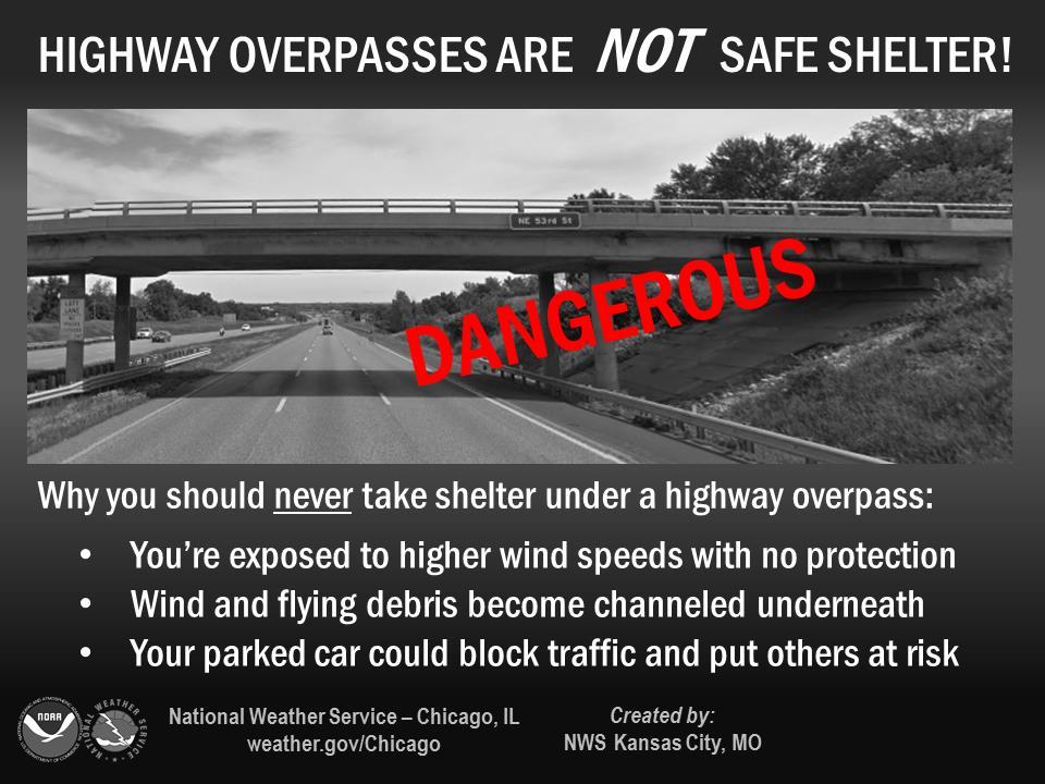
41 Preparing for the Next Big Event Overpass: Exposure to Winds Image: Google Overpasses are NOT adequate storm shelters!

42 Preparing for the Next Big Event Overpass: Other Issues Blocks traffic Prevents Emergency Personnel from reaching affected areas Potential major traffic disaster in situations of low visibility
43
44 Conclusion June 7, 2008 had 8 tornadoes from 1 supercell Location affected was somewhat of a surprise More conditional threat, initial focus was northwest EF2 tornado crossed I-57, extensive impacts to Richton Park, supercell path narrowly missed additional communities Always remember safe spotter positioning Cyclic supercells can be unpredictable, apparently erratic tornado tracks (tornado path jumps ) Important to understand characteristics since new mesocyclone tends to develop closer to well positioned spotter Severe weather planning and safety: Goal is to not put yourself in a vulnerable situation!
45 Acknowledgements & References Izzi, Gino (2009). The June 7th, 2008 Suburban Chicago Cyclic Tornadic Supercell. Presented at 2009 DuPage Seminar. NWS Chicago (2008). June 7, 2008 Severe Weather Event. Friedlein and Bardou (2017). Weather Ready Reminders of the 1967 Outbreak. Presented at 2017 Fermilab Seminar. Thompson, Rich. Explanation of SPC Severe Weather Parameters. Houston CWSU NWS. Mesoscale Analysis Parameters. _parameters/sounding_stuff/mesoscaleparameters.html Thank you to DuPage OHSEM for hosting this event and to the attendees for being a great audience!
Tornadogenesis in Supercells: The Three Main Ingredients. Ted Funk
 Tornadogenesis in Supercells: The Three Main Ingredients Ted Funk NWS Louisville, KY Spring 2002 Environmental Parameters Supercells occur within environments exhibiting several wellknown characteristics
Chapter 14 Thunderstorm Fundamentals
 Chapter overview: Thunderstorm appearance Thunderstorm cells and evolution Thunderstorm types and organization o Single cell thunderstorms o Multicell thunderstorms o Orographic thunderstorms o Severe
Advanced Spotter Training: Anticipating Severe Weather Threats. Professor Paul Sirvatka College of DuPage Meteorology
 Advanced Spotter Training: Anticipating Severe Weather Threats College of DuPage Meteorology Preparing for Severe Weather Preparedness involves understanding the probable and potential threats. Understanding
Tornadoes forecasting, dynamics and genesis. Mteor 417 Iowa State University Week 12 Bill Gallus
 Tornadoes forecasting, dynamics and genesis Mteor 417 Iowa State University Week 12 Bill Gallus Tools to diagnose severe weather risks Definition of tornado: A vortex (rapidly rotating column of air) associated
MET Lecture 29 Tornadoes IV
 MET 4300 Lecture 29 Tornadoes IV Outline Definition, life cycle, & climatology of tornadoes Tornado formation within supercells Tornado formation within nonsupercell thunderstorms Fujita scale Tornado
Tornadoes. tornado: a violently rotating column of air
 Tornadoes tornado: a violently rotating column of air Tornadoes What is the typical size of a tornado? What are typical wind speeds for a tornado? Five-stage life cycle of a tornado Dust Swirl Stage Tornado
Tornadoes forecasting, dynamics and genesis. Mteor 417 Iowa State University Week 12 Bill Gallus
 Tornadoes forecasting, dynamics and genesis Mteor 417 Iowa State University Week 12 Bill Gallus Tools to diagnose severe weather risks Definition of tornado: A vortex (rapidly rotating column of air) associated
NOAA S National Weather Service
 NOAA S National Weather Service Elite Concepts of Severe Storm Spotting 2011 Rusty Kapela Milwaukee/Sullivan www.weather.gov/mkx Elite Spotter Outline Review Types of T storms Tornadic Supercell Classic,
Review of Basic Severe Thunderstorm & Tornado Spotting Concepts. Jim Allsopp National Weather Service Chicago/Romeoville, IL
 Review of Basic Severe Thunderstorm & Tornado Spotting Concepts Jim Allsopp National Weather Service Chicago/Romeoville, IL Why Do We Need Spotters? Radar has limitations, only spotters can provide view
NOAA S National Weather Service
 NOAA S National Weather Service Night Spotting Advanced Concepts of Severe Storm Spotting 2012 Rusty Kapela Milwaukee/Sullivan Weather.gov/milwaukee Problems Spotters Encounter Spotters can only see a
The Severe Weather Event of 7 August 2013 By Richard H. Grumm and Bruce Budd National Weather Service State College, PA 1. INTRODUCTION and Overview
 The Severe Weather Event of 7 August 2013 By Richard H. Grumm and Bruce Budd National Weather Service State College, PA 1. INTRODUCTION and Overview A fast moving short-wave (Fig. 1) with -1σ 500 hpa height
MET Lecture 26 Tornadoes I
 MET 4300 Lecture 26 Tornadoes I A Large Tornado approaches Lyndon, Kansas, on May 8, 2003 Outline Definition, life cycle Tornado formation within supercells Tornado formation within nonsupercell thunderstorms
P8.14 CLASSIC AND HP MINI-SUPERCELLS IN SOUTHEAST OREGON AND SOUTHWEST IDAHO ON 3 MAY
 P8.14 CLASSIC AND HP MINI-SUPERCELLS IN SOUTHEAST OREGON AND SOUTHWEST IDAHO ON 3 MAY 2009 Stephen S. Parker* National Weather Service, Boise, ID 1. INTRODUCTION During the early afternoon hours of 3 May
Advanced Spotter Training Lesson 4: The Nature of Thunderstorms
 Advanced Spotter Training 2009 Lesson 4: The Nature of Thunderstorms From Last Time We discussed the different ways to make air rise. We discussed convection, convergence, and the different kinds of fronts.
Marine Weather Primer
 1 of 73 Marine Weather Primer Mark A. Thornton LakeErieWX: Marine Weather Education and Forecasting Resources Mark@LakeErieWX.com 2 of 73 3 of 73 Marine Weather Seminars & Workshops Learn a little meteorology
Chapter 3 Convective Dynamics Part VI. Supercell Storms. Supercell Photos
 Chapter 3 Convective Dynamics Part VI. Supercell Storms Photographs Todd Lindley (This part contains materials taken from UCAR MCS training module) Supercell Photos 1 Introduction A supercel storm is defined
SKYWARN Reporting via Ham Radio. MSUARC, April 10, 2018 Bill Call, KJ4W with assistance from Christine Wielgos, NWS
 SKYWARN Reporting via Ham Radio MSUARC, April 10, 2018 Bill Call, KJ4W with assistance from Christine Wielgos, NWS Topics What is SKYWARN? How to Select a Good Vantage Point, if Mobile What Phenomena Are
50 th Anniversary of the Oak Lawn Tornado
 50 th Anniversary of the Oak Lawn Tornado 2017 DuPage County Advanced Severe Weather Seminar National Weather Service Chicago Mike Bardou Stephen Rodriguez Outline 1967 Belvidere, Lake Zurich, and Oak
P3.17 THE DEVELOPMENT OF MULTIPLE LOW-LEVEL MESOCYCLONES WITHIN A SUPERCELL. Joshua M. Boustead *1 NOAA/NWS Weather Forecast Office, Topeka, KS
 P3.17 THE DEVELOPMENT OF MULTIPLE LOW-LEVEL MESOCYCLONES WITHIN A SUPERCELL Joshua M. Boustead *1 NOAA/NWS Weather Forecast Office, Topeka, KS Philip N. Schumacher NOAA/NWS Weather Forecaster Office, Sioux
Meteorology Lecture 19
 Meteorology Lecture 19 Robert Fovell rfovell@albany.edu 1 Important notes These slides show some figures and videos prepared by Robert G. Fovell (RGF) for his Meteorology course, published by The Great
Thunderstorms. Ordinary Cell Thunderstorms. Ordinary Cell Thunderstorms. Ordinary Cell Thunderstorms 5/2/11
 A storm containing lightning and thunder; convective storms Chapter 14 Severe thunderstorms: At least one: large hail wind gusts greater than or equal to 50 kt Tornado 1 2 Ordinary Cell Ordinary Cell AKA
Thunderstorm: a cumulonimbus cloud or collection of cumulonimbus clouds featuring vigorous updrafts, precipitation and lightning
 Thunderstorm: a cumulonimbus cloud or collection of cumulonimbus clouds featuring vigorous updrafts, precipitation and lightning Thunderstorm: a cumulonimbus cloud or collection of cumulonimbus clouds
TOPICS: What are Thunderstorms? Ingredients Stages Types Lightning Downburst and Microburst
 THUNDERSTORMS TOPICS: What are Thunderstorms? Ingredients Stages Types Lightning Downburst and Microburst What are Thunderstorms? A storm produced by a cumulonimbus cloud that contains lightning and thunder
1 of 7 Thunderstorm Notes by Paul Sirvatka College of DuPage Meteorology. Thunderstorms
 1 of 7 Thunderstorm Notes by Paul Sirvatka College of DuPage Meteorology Thunderstorms There are three types of thunderstorms: single-cell (or air mass) multicell (cluster or squall line) supercell Although
Radar Meteorology AOS 444 October 28, 2002 Laboratory 6: WATADS study of Oakfield tornado from KGRB
 Radar Meteorology AOS 444 October 28, 2002 Laboratory 6: WATADS study of Oakfield tornado from KGRB YOUR NAME: YOUR PARTNER S NAME: On July 18, 1996 the town of Oakfield, Wisconsin was all but destroyed
DEPARTMENT OF EARTH & CLIMATE SCIENCES NAME SAN FRANCISCO STATE UNIVERSITY Fall ERTH FINAL EXAMINATION KEY 200 pts
 DEPARTMENT OF EARTH & CLIMATE SCIENCES NAME SAN FRANCISCO STATE UNIVERSITY Fall 2016 Part 1. Weather Map Interpretation ERTH 365.02 FINAL EXAMINATION KEY 200 pts Questions 1 through 9 refer to Figure 1,
Weather Systems III: Thunderstorms and Twisters
 Weather Systems III: Thunderstorms and Twisters Review 1. Definition of airmasses? Bergeron classification of air masses 2. Surface weather analysis: Station model, wind speed code, present weather 3.
P12.7 MESOCYCLONE AND RFD INDUCED DAMAGING WINDS OBSERVED IN THE 27 MAY 2004 SOUTHWEST OHIO SUPERCELL
 P12.7 MESOCYCLONE AND RFD INDUCED DAMAGING WINDS OBSERVED IN THE 27 MAY 2004 SOUTHWEST OHIO SUPERCELL John T. DiStefano* National Weather Service Office, Wilmington, Ohio 1. INTRODUCTION During the early
Tornado Occurrences. Tornadoes. Tornado Life Cycle 4/12/17
 Chapter 19 Tornadoes Tornado Violently rotating column of air that extends from the base of a thunderstorm to the ground Tornado Statistics Over (100, 1000, 10000) tornadoes reported in the U.S. every
Meteorology. Chapter 10 Worksheet 2
 Chapter 10 Worksheet 2 Meteorology Name: Circle the letter that corresponds to the correct answer 1) Downdrafts totally dominate the in the development of a thunderstorm. a) dissipating stage b) mature
Severe Thunderstorms. MET 200 Lecture 24 Flooding in Hawaii and Intro to Severe Thunderstorms. MET 200 Lecture 24 Severe Thunderstorms.
 MET 200 Lecture 24 Severe Thunderstorms Damage Swath 1 2 MET 200 Lecture 24 Flooding in Hawaii and Intro to Severe Thunderstorms Severe Thunderstorms Kona Lows Cause more flash floods in Hawaii than any
2013 Tornado and Severe Weather Awareness Drill
 2013 Tornado and Severe Weather Awareness Drill Scheduled for Thursday April 18, 2013 The 2013 Tornado Drill will consist of a mock tornado watch and a mock tornado warning for all of Wisconsin. This is
Storm Hazards covered in this course
 Chasing Tornadoes (LG: 3a) A video Teaser, while students enter the classroom. Day3-60 Tornadoes of 2016 (16:05) Pecos Hank channel https://www.youtube.com/watch?v=nzmtglwx0n4 Watch on your own: 2016 and
3 Severe Weather. Critical Thinking
 CHAPTER 2 3 Severe Weather SECTION Understanding Weather BEFORE YOU READ After you read this section, you should be able to answer these questions: What are some types of severe weather? How can you stay
Tornadoes. Be able to define what a tornado is. Be able to list several facts about tornadoes.
 Tornadoes Be able to define what a tornado is. Be able to list several facts about tornadoes. 1. Where do tornadoes most U.S. is # 1 occur in the world? Tornadoes are most common in Tornado Alley. Tornado
Thunderstorm: a cumulonimbus cloud or collection of cumulonimbus clouds featuring vigorous updrafts, precipitation and lightning
 Thunderstorm: a cumulonimbus cloud or collection of cumulonimbus clouds featuring vigorous updrafts, precipitation and lightning Thunderstorms are responsible for most of what we refer to as severe weather,
May 16, 2009 (Part II) - A Mesoscale and Radar Perspective of the Tornadic Supercells. Michael L. Jurewicz, Sr. WFO BGM
 - A Mesoscale and Radar Perspective of the Tornadic Supercells. Michael L. Jurewicz, Sr. WFO BGM") May 16, 2009 (Part II) - A Mesoscale and Radar Perspective of the Tornadic Supercells Michael L. Jurewicz, Sr. WFO BGM Mesoscale Boundary Assistance A pre-frontal trough formed across Western NY / PA early
May 16, 2009 (Part II) - A Mesoscale and Radar Perspective of the Tornadic Supercells Michael L. Jurewicz, Sr. WFO BGM Mesoscale Boundary Assistance A pre-frontal trough formed across Western NY / PA early
Severe Weather Event of 13 July 2014
 Severe Weather Event of 13 July 2014 By Richard H. Grumm and Elyse M. Colbert National Weather Service State College, PA 1. Overview Severe weather affected the eastern United States (Fig. 1) from northwestern
TROPICAL CYCLONE TORNADOES
 TROPICAL CYCLONE TORNADOES 2018 GOVERNOR S HURRICANE CONFERENCE TUESDAY, MAY 15, 2018 WILL ULRICH NWS FORECAST OFFICE MELBOURNE WHERE ARE THE TORNADOES? WHERE ARE THE TORNADOES? C B A WEST MELBOURNE, FL
contact with ground for 1 hour plus, starting 1500 MDT moved N., covered about 37 km width varied m
 Goal for today: Finish Ch. 11 Lightning, Thunder & Tornadoes 16 Nov., 2011 Edmonton tornado 31 July 1987 contact with ground for 1 hour plus, starting 1500 MDT moved N., covered about 37 km width varied
IN VEHICLES: Do not try to outrun a tornado. Abandon your vehicle and hide in a nearby ditch or depression and cover your head.
 TORNADO SAFETY TORNADO! The very word strikes fear in many people. While a tornado is perhaps nature's most destructive storm, deaths and injuries can be prevented. By following Tornado Safety Rules, lives
The National Oceanic and Atmospheric Administration (NOAA) National Weather Service (NWS) Severe Thunderstorm Observing and Radar Monitoring
 National Weather Service (NWS) Severe Thunderstorm Observing and Radar Monitoring") The National Oceanic and Atmospheric Administration (NOAA) Presents National Weather Service (NWS) Severe Thunderstorm Observing and Radar Monitoring Severe Weather Spotter Line 1-888-668-3344 Spotter
The National Oceanic and Atmospheric Administration (NOAA) Presents National Weather Service (NWS) Severe Thunderstorm Observing and Radar Monitoring Severe Weather Spotter Line 1-888-668-3344 Spotter
4/18/2010. National Weather Service. Severe Weather Forecasting: A Western North Carolina Case Study
 National Weather Service Severe Weather Forecasting: A Western North Carolina Case Study Laurence G. Lee Science and Operations Officer National Weather Service Greer, SC Plus 13 River Forecast Centers
1st Tornado Photograph
 Lecture 26 Part II Tornados Environment Storm Structure Life Cycle Source of Spin Forecasting Climatology Damage Marilee Thomas of Beaver City, NE took this photograph of her daughter Audra about two miles
Flooding and Severe weather of 27 June 2013
 Flooding and Severe weather of 27 June 2013 By Richard H. Grumm National Weather Service State College, PA 1. Overview Flooding and severe weather affected Pennsylvania on 27 June 2013 (Fig 1). The severe
Module 11: Meteorology Topic 6 Content: Severe Weather Notes
 Severe weather can pose a risk to you and your property. Meteorologists monitor extreme weather to inform the public about dangerous atmospheric conditions. Thunderstorms, hurricanes, and tornadoes are
Practical Use of the Skew-T, log-p diagram for weather forecasting. Primer on organized convection
 Practical Use of the Skew-T, log-p diagram for weather forecasting Primer on organized convection Outline Rationale and format of the skew-t, log-p diagram Some basic derived diagnostic measures Characterizing
Tornadoes. A. T. Willett/The Image Bank/Getty Images
 Tornadoes A. T. Willett/The Image Bank/Getty Images Created by Chelsea Austin Introduction to Physical Science, EMPACTS Project, Fall 2012 How are Tornadoes related to Hurricanes? Tornadoes are spawned
Chapter 8 cont. Clouds and Storms. Spring 2018
 Chapter 8 cont. Clouds and Storms Spring 2018 Clouds and Storms Clouds cover ~ 50% of earth at any time. Clouds are linked to a number of condensation processes. Cloud morphology, cloud types, associated
The 2015 NWS Spring and Summer Weather Update
 http://weather.gov The 2015 NWS Spring and Summer Weather Update Western North Carolina severe weather climatology Tony Sturey, WCM Greenville/Spartanburg, SC North Carolina Spring and Summer Outlooks
Severe Thunderstorm Forecasting and Climatology in Arizona. Ken Drozd Warning Coordination Meteorologist NOAA/NWS Tucson, AZ
 Severe Thunderstorm Forecasting and Climatology in Arizona Ken Drozd Warning Coordination Meteorologist NOAA/NWS Tucson, AZ THUNDERSTORM FORMATION All thunderstorms result from the same necessary conditions
Severe Weather with a strong cold front: 2-3 April 2006 By Richard H. Grumm National Weather Service Office State College, PA 16803
 Severe Weather with a strong cold front: 2-3 April 2006 By Richard H. Grumm National Weather Service Office State College, PA 16803 1. INTRODUCTION A strong cold front brought severe weather to much of
Comparison of November 15, 2008 Killer Tornado Outbreak with the December 2, 2009 Non Tornado Event
 Comparison of November 15, 2008 Killer Tornado Outbreak with the December 2, 2009 Non Tornado Event The two events featured similar patterns but with much different results in central NC. The slides on
Foundations of Earth Science, 6e Lutgens, Tarbuck, & Tasa
 Foundations of Earth Science, 6e Lutgens, Tarbuck, & Tasa Weather Patterns and Severe Weather Foundations, 6e - Chapter 14 Stan Hatfield Southwestern Illinois College Air masses Characteristics Large body
Chapter 3 Convective Dynamics 3.4. Bright Bands, Bow Echoes and Mesoscale Convective Complexes
 Chapter 3 Convective Dynamics 3.4. Bright Bands, Bow Echoes and Mesoscale Convective Complexes Photographs Todd Lindley Bright band associated with stratiform precipitation in a squall line system 1 Bright
24 TH CONFERENCE ON SEVERE LOCAL STORMS, OCTOBER 2008, SAVANNAH, GEORGIA
 P9.13 SUPER-RESOLUTION POLARIMETRIC OBSERVATIONS OF A CYCLIC TORNADIC SUPERCELL MATTHEW R. KUMJIAN*, ALEXANDER V. RYZHKOV, AND VALERY M. MELNIKOV Cooperative Institute for Mesoscale Meteorological Studies,
Mid Atlantic Severe Event of 1 May 2017 Central Pennsylvania QLCS event By Richard H. Grumm National Weather Service, State College, PA 16803
 1. Overview Mid Atlantic Severe Event of 1 May 2017 Central Pennsylvania QLCS event By Richard H. Grumm National Weather Service, State College, PA 16803 A strong upper-level wave (Fig.1) moving into a
Weather Patterns and Severe Storms
 Weather Patterns and Severe Storms 20.1 Air Masses Air Masses and Weather Air Masses An air mass is an immense body of air that is characterized by similar temperatures and amounts of moisture at any given
10/21/2012. Chapter 10 Thunderstorms. Part II. Growth and Development of ordinary Cell Thunderstorms Thunderstorm Electrification.
 Chapter 10 Thunderstorms Part I Growth and Development of ordinary Cell Thunderstorms Thunderstorm Electrification Tornadoes Part II Simplified model depicting the life cycle of an ordinary thunderstorm
HURRICANES AND TORNADOES
 HURRICANES AND TORNADOES The most severe weather systems are hurricanes and tornadoes. They occur in extremely low pressure systems, or cyclones, when the air spirals rapidly into the center of a low.
Low-end derecho of 19 August 2017
 Low-end derecho of 19 August 2017 By Richard H. Grumm and Charles Ross National Weather Service State College, PA 1. Overview A cluster of thunderstorms developed in eastern Ohio around 1800 UTC on 19
Inner core dynamics: Eyewall Replacement and hot towers
 Inner core dynamics: Eyewall Replacement and hot towers FIU Undergraduate Hurricane Internship Lecture 4 8/13/2012 Why inner core dynamics is important? Current TC intensity and structure forecasts contain
ESCI 241 Meteorology Lesson 19 Tropical Cyclones Dr. DeCaria
 ESCI 241 Meteorology Lesson 19 Tropical Cyclones Dr. DeCaria READING: Chapter 16 GENERAL A tropical cyclone is a large, low-pressure system that forms over the tropical oceans. Tropical cyclones are classified
Air Masses, Fronts, Storm Systems, and the Jet Stream
 Air Masses, Fronts, Storm Systems, and the Jet Stream Air Masses When a large bubble of air remains over a specific area of Earth long enough to take on the temperature and humidity characteristics of
Tornado Dynamics. Readings:
 Tornado Dynamics Readings: Klemp (1987) Dynamics of Tornadic Thunderstorms (handout) Bluestein Vol II. Section 3.4.8. Rotunno, R., 1986: Tornadoes and tornadogenesis. In: P. Ray (Editor), Mesoscale Meteorology
Severe Thunderstorms
 Lecture 26 Severe Thunderstorms NWS Criteria Environment Structure Climatology 1 Severe Thunderstorms NWS Criteria Environment Structure Climatology 2 Severe Thunderstorms: NWS Criteria NWS Criteria: to
Your Task: Read each slide then use the underlined red or underlined information to fill in your organizer.
 Severe Weather: Tornadoes and Hurricanes Thunderstorms and Lightning S6E4 d. Construct an explanation of the relationship between air pressure, weather fronts, and air masses and meteorological events
COMMUNITY EMERGENCY RESPONSE TEAM TORNADOES
 Tornadoes are powerful, circular windstorms that may be accompanied by winds in excess of 200 miles per hour. Tornadoes typically develop during severe thunderstorms and may range in width from several
Severe Weather Information
 Severe Weather Information TORNADO FACTS Canada gets more tornadoes than any other country with the exception of the United States. Tornadoes are rotating columns of high winds. Sometimes they move quickly
P4.479 A DETAILED ANALYSIS OF SPC HIGH RISK OUTLOOKS,
 P4.479 A DETAILED ANALYSIS OF SPC HIGH RISK OUTLOOKS, 2003-2009 Jason M. Davis*, Andrew R. Dean 2, and Jared L. Guyer 2 Valparaiso University, Valparaiso, IN 2 NOAA/NWS Storm Prediction Center, Norman,
Test Form: A Key Final Exam: Spring 2011
 Test Form: A Key Final Exam: Spring 2011 Instructions: Write your name (last name and first name) on your bubble sheet. Write your student identification number on the bubble sheet, and carefully and completely
Investigating the Environment of the Indiana and Ohio Tornado Outbreak of 24 August 2016 Using a WRF Model Simulation 1.
 Investigating the Environment of the Indiana and Ohio Tornado Outbreak of 24 August 2016 Using a WRF Model Simulation Kevin Gray and Jeffrey Frame Department of Atmospheric Sciences, University of Illinois
Tornadoes pose a high risk because the low atmospheric pressure, combined with high wind velocity, can:
 Tornadoes are powerful, circular windstorms that may be accompanied by winds in excess of 200 miles per hour. Tornadoes typically develop during severe thunderstorms and may range in width from several
Chapter 21. Weather Patterns and Severe Storms
 Chapter 21 Weather Patterns and Severe Storms 20.1 Air Masses Air Masses and Weather Air Masses An air mass is an immense body of air that is characterized by similar temperatures and amounts of moisture
TORNADOES. DISPLAY VISUAL A Tornado Is... Tornadoes can: Rip trees apart. Destroy buildings. Uproot structures and objects.
 TORNADOES Introduce tornadoes by explaining what a tornado is. DISPLAY VISUAL A Tornado Is... A powerful, circular windstorm that may be accompanied by winds in excess of 250 miles per hour. Tell the participants
The Oakfield, Wisconsin, Tornado from July Brett Berenz Student at the University of Wisconsin
 The Oakfield, Wisconsin, Tornado from 18-19 July 1996 Brett Berenz Student at the University of Wisconsin Abstract On July 18 th, 1996 an F5 tornado affected the region of Oakfield, Wisconsin. Leading
Science Olympiad Meteorology Quiz #2 Page 1 of 8
 1) The prevailing general direction of the jet stream is from west to east in the northern hemisphere: 2) Advection is the vertical movement of an air mass from one location to another: 3) Thunderstorms
HAZARDOUS WEATHER 1. Dr. Julie Laity Geography 266
 HAZARDOUS WEATHER 1 Dr. Julie Laity Geography 266 Violent Weather Thunderstorms Atmospheric turbulence Lightning and thunder Hail Derechos Tornadoes Tornado measurement and science Tropical Cyclones Hurricanes
P10.4 EXAMINATION OF TORNADIC AND NON-TORNADIC SUPERCELLS IN SOUTHWEST VIRGINIA ON 28 APRIL 2002
 P10.4 EXAMINATION OF TORNADIC AND NON-TORNADIC SUPERCELLS IN SOUTHWEST VIRGINIA ON 28 APRIL 2002 Steve Keighton*, Kenneth Kostura, and Chris Liscinsky NOAA/National Weather Service Blacksburg, VA 1. INTRODUCTION
P10.18 ORIGINS OF THE GRANITE FALLS, MN TORNADO, JULY 25, 2000 REVISITED
 P10.18 ORIGINS OF THE GRANITE FALLS, MN TORNADO, JULY 25, 2000 REVISITED Doug Dokken, Rich Naistat, Bill Togstad, and Kurt Scholz. Keenan Weise, John Nelson, Luke Edholm, and Pat Shanahan. 1. INTRODUCTION
Hurricanes. April 14, 2009
 Tropical Weather & Hurricanes Chapter 15 April 14, 2009 Tropical meteorology Tropics characterized by seasonal wet and drier periods- wet when sun is nearly overhead at noon and inter-tropical convergence
November 22, 1992, I-71, Carroll County KY by Irma Doran
 November 22, 1992, I-71, Carroll County KY by Irma Doran The World s First Tornado Scientist 1885 April 26, 1884 near Garnett, KS by A.A. Adams The World s First Tornado Photograph August 28, 1884
CHAPTER 12 TROPICAL WEATHER SYSTEMS MULTIPLE CHOICE QUESTIONS
 CHAPTER 12 TROPICAL WEATHER SYSTEMS MULTIPLE CHOICE QUESTIONS 1. A hurricane differs from an extra-tropical cyclone in that a hurricane a. has no fronts. b. develops within a uniform warm and humid air
The Earth System - Atmosphere III Convection
 The Earth System - Atmosphere III Convection Thunderstorms 1. A thunderstorm is a storm that produces lightning (and therefore thunder) 2. Thunderstorms frequently produce gusty winds, heavy rain, and
Lecture Outlines PowerPoint. Chapter 19 Earth Science 11e Tarbuck/Lutgens
 Lecture Outlines PowerPoint Chapter 19 Earth Science 11e Tarbuck/Lutgens 2006 Pearson Prentice Hall This work is protected by United States copyright laws and is provided solely for the use of instructors
Earth Science, 11e. Weather Patterns and Severe Storms Chapter 19. Air masses. A cold Canadian air mass Figure Air masses. Air masses 9/5/2012
 2006 Pearson Prentice Hall Lecture Outlines PowerPoint Chapter 19 Earth Science 11e Tarbuck/Lutgens This work is protected by United States copyright laws and is provided solely for the use of instructors
Tornadoes. Tornadoes COMMUNITY EMERGENCY RESPONSE TEAM TORNADOES
 Tornadoes Tornadoes Tell the participants that tornadoes are powerful, circular windstorms that may be accompanied by winds in excess of 200 miles per hour. Tornadoes typically develop during severe thunderstorms
Mature Tornado. Tornado funnel and debris cloud. Mature Tornado
 Mature Tornado Tornado funnel and debris cloud 43 Mature Tornado 44 Tornado in Final Rope Stage 45 Source of Spin 46 Source of Spin Updraft Stretches Rotating Column 47 Simulation of Tornado Formation
Solutions to Comprehensive Final Examination Given on Thursday, 13 December 2001
 Name & Signature Dr. Droegemeier Student ID Meteorology 1004 Introduction to Meteorology Fall, 2001 Solutions to Comprehensive Final Examination Given on Thursday, 13 December 2001 BEFORE YOU BEGIN!! Please
16 September 2005 Northern Pennsylvania Supercell Thunderstorm by Richard H. Grumm National Weather Service Office State College, PA 16803
 16 September 2005 Northern Pennsylvania Supercell Thunderstorm by Richard H. Grumm National Weather Service Office State College, PA 16803 1. INTRODUCTION During the afternoon hours of 16 September 2005,
2/27/2015. Big questions. What can we say about causes? Bottom line. Severe Thunderstorms, Tornadoes, and Climate Change: What We Do and Don t Know
 Severe Thunderstorms, Tornadoes, and Climate Change: What We Do and Don t Know Big questions How and why are weather hazards distributed? Are things changing in time and will they? HAROLD BROOKS NOAA/NSSL
Severe Weather Shelters
 Severe Weather Shelters When tornadoes and other severe weather affect your area, it is incredibly important that you know where a good shelter is. In general these are some characteristics of a GOOD tornado/severe
CLOUDS & THUNDERSTORMS
 Funding provided by NOAA Sectoral Applications Research Project CLOUDS & THUNDERSTORMS Basic Climatology Oklahoma Climatological Survey How are clouds made? Clouds form when air is cooled to its dewpoint
Meteorology Lecture 18
 Meteorology Lecture 18 Robert Fovell rfovell@albany.edu 1 Important notes These slides show some figures and videos prepared by Robert G. Fovell (RGF) for his Meteorology course, published by The Great
P3.36 An Evaluation of the Potential Impact of SAILS on the Warning Decision Making of the 31 May 2013 El Reno, OK Storm
 P3.36 An Evaluation of the Potential Impact of on the Warning Decision Making of the 31 May 2013 El Reno, OK Storm Michael A. Magsig 1 and Marcus D. Austin 2 1 Warning Decision Training Branch, 2 OUN National
Anthony A. Rockwood Robert A. Maddox
 Anthony A. Rockwood Robert A. Maddox An unusually intense MCS produced large hail and wind damage in northeast Kansas and northern Missouri during the predawn hours of June 7 th, 1982. Takes a look at
J. Brad McGavock*, Robert B. Darby, Steven F. Piltz
 P1.9 Interactive Mesoscale Analysis Utilized in Assisting Local Decision Makers: A Review of the 24 March 2005 Supercell 1. INTRODUCTION J. Brad McGavock*, Robert B. Darby, Steven F. Piltz Severe weather
April 13, 2006: Analysis of the Severe Thunderstorms that produced Hail in Southern Wisconsin
 April 13, 2006: Analysis of the Severe Thunderstorms that produced Hail in Southern Wisconsin Danielle Triolo UW Madison Undergraduate 453 Case Study May 5, 2009 ABSTRACT On April 13, 2006 the states of
AN INVESTIGATION OF THE SIGNIFICANT TORNADO OUTBREAK IN SOUTHERN SOUTH CAROLINA AND NORTH COASTAL GEORGIA ON MARCH 15, 2008
 P3.6 AN INVESTIGATION OF THE SIGNIFICANT TORNADO OUTBREAK IN SOUTHERN SOUTH CAROLINA AND NORTH COASTAL GEORGIA ON MARCH 15, 2008 Frank W. Alsheimer*, Robert Bright, Jonathon Jelsema, Wendy Moen, John Quagliariello,
Lightning. lightning: an electrical discharge in the atmosphere. Electricity. Lightning, Thunder and Tornados PHYS 189. Electricity.
 , lightning: an electrical discharge in the atmosphere (), week 12 1 / 40 , lightning: an electrical discharge in the atmosphere cloud-to-cloud (80%) cloud-to-ground (20%) (), week 12 1 / 40 Fundamentals