Comparison of November 15, 2008 Killer Tornado Outbreak with the December 2, 2009 Non Tornado Event
|
|
|
- Roy McKenzie
- 5 years ago
- Views:
Transcription
1 Comparison of November 15, 2008 Killer Tornado Outbreak with the December 2, 2009 Non Tornado Event The two events featured similar patterns but with much different results in central NC. The slides on the following pages are designed to serve as a reference for discussion. In many aspects, the events were very similar with the synoptic upper air and surface pattern. One obvious difference between the two events is a much greater amount of surface based CAPE in the 11/15 case then the 12/02 event which would obviously support more surface based convection and allow a storm to utilize the surface instability and drive a circulation to the surface. A review of the radar imagery shows that at the time of the tornadoes in central NC, the convection during the 11/15 event was not embedded in a large convective rain shield as was the case with the 12/02 event. In addition, the 11/15 tornadic supercells were long lived, originating in SC in a region of similar instability to that over eastern NC where they eventually produced tornadoes. I believe the 1988 Raleigh Tornado was spawned by a long lived supercell originating in SC. More recently, on March 28, 2010, a long lived supercell produced 4 tornadoes in the western Piedmont of North Carolina with the first tornado touching down just north of the South Carolina state line. Jonathan Blaes NOAA/NWS Raleigh, NC


2

3 On 2009/12/09 there were several reports of wind damage in the southern and central Coastal Plain of NC. Other severe weather was observed during the afternoon across GA/SC. Most of the severe weather on was reported as tornadoes and related to one or two long lived supercells.
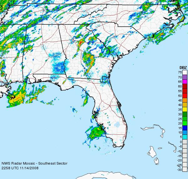
4 No tornadoes were confirmed during the evening or early morning hours of 12/03/09 Most of the tornadoes on 11/15/08 occurred between 07 and 09 UTC
5 2009/12/03
6

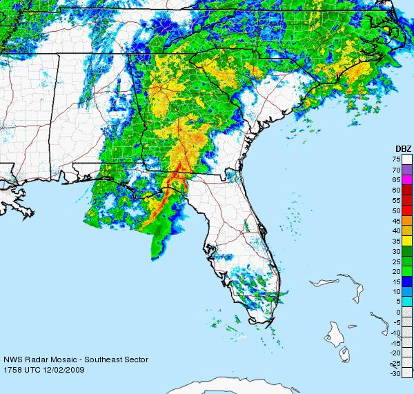
7 2009/12/02

8 MESOSCALE DISCUSSION 2191 NWS STORM PREDICTION CENTER NORMAN OK 0731 PM CST WED DEC AREAS AFFECTED...ERN SC...ERN NC CONCERNING...TORNADO WATCH VALID Z Z THE SEVERE WEATHER THREAT FOR TORNADO WATCH 789 CONTINUES. THE TORNADO THREAT ACROSS WW 791 WILL CONTINUE TO INCREASE ACROSS NC OVER THE NEXT 1-2 HOURS. A NEW TORNADO WATCH WILL LIKELY BE NEEDED WITHIN THE HOUR ACROSS CNTRL NC INTO SERN VA. THE AIRMASS ACROSS WW 791 IS RAPIDLY DESTABILIZING DUE TO STRONG MOISTURE ADVECTION AS A WARM FRONT MOVES QUICKLY NWD ACROSS NC. SFC DEWPOINTS ARE ALREADY IN THE UPPER 60S F IN GREENVILLE NC AND THIS MOISTURE SHOULD REACH THE NC-VA STATE-LINE DURING THE 02Z TO 03 TIMEFRAME. THE MOISTURE COMBINED WITH A STRONG SHEAR ENVIRONMENT ALREADY IN PLACE IS INCREASING THE POTENTIAL FOR ROTATING STORMS AND TORNADOES. TORNADOES WILL BE POSSIBLE WITH DISCRETE CELLS AHEAD OF A BAND OF RAIN CURRENTLY WEST OF THE RALEIGH/DURHAM VICINITY. ROTATING CELLS WILL ALSO BE POSSIBLE EMBEDDED IN THE RAIN BAND ESPECIALLY SWD TOWARD THE SC STATE-LINE WHERE SFC DEWPOINTS ARE APPROACHING 70 F. AS LARGE-SCALE ASCENT SPREADS ACROSS NC...THE LOW-LCL HEIGHTS AND 0-1 KM SHEAR OF KT SHOULD SUPPORT SUPERCELL DEVELOPMENT WITH A STRONG TORNADO POSSIBLE AS THE LOW-LEVEL JET SHIFTS NNEWD INTO THE CNTRL PART OF WW BROYLES.. 12/03/2009

9 MESOSCALE DISCUSSION 2386 NWS STORM PREDICTION CENTER NORMAN OK 0210 AM CST SAT NOV CONCERNING...TORNADO WATCH VALID Z Z THE SEVERE WEATHER THREAT FOR TORNADO WATCH CONTINUES. TORNADO WATCHES 932/933 CONTINUE ACROSS EASTERN SC AND CENTRAL/EASTERN NC UNTIL 11Z/13Z RESPECTIVELY...WITH A RECENTLY ISSUED WFO EXTENSION ACROSS FAR SOUTHEAST VA. A DISTINCT RISK FOR ISOLATED TORNADOES AND WIND DAMAGE WILL CONTINUE OVERNIGHT. LATEST SUBJECTIVE SURFACE ANALYSIS FEATURES A GENERAL SW-NE ORIENTED WARM FRONT FROM NORTHERN GA INTO UPSTATE SC/EAST CENTRAL NC AND SOUTHEAST VA...WITH UPPER 60S/LOWER 70S F SURFACE DEWPOINTS PREVALENT EAST OF THIS BOUNDARY. A NORTHEAST-ADVANCING EMBEDDED SPEED MAXIMA AND A FAVORABLE KINEMATIC/HIGHLY SHEARED ENVIRONMENT WILL CONTINUE TO CONTRIBUTE TO WELL-ORGANIZED TSTMS INCLUDING SUPERCELLS/BOWS ALONG AND EAST OF THIS WARM FRONT ACROSS EASTERN SC AND ESPECIALLY EASTERN NC...AND INTO SOUTHEAST VA WITHIN THE NEXT FEW HOURS. TORNADO DAMAGE WAS RECENTLY REPORTED SOUTHEAST OF THE RALEIGH AREA IN JOHNSTON COUNTY. REGIONAL WSR-88D DERIVED WIND PROFILES REFLECT A STRONG LOW LEVEL JET WITH KT SOUTH-SOUTHWESTERLY FLOW AROUND 1 KM...WHICH IS CONTRIBUTING TO MS/S2 0-1 KM SRH...GUYER.. 11/15/2008


10 300 hpa

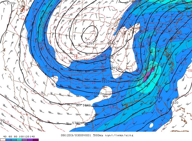
11 500 hpa

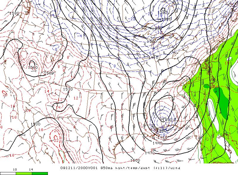
12 850 hpa

13 Surface Theta-E


14 SBCAPE


15 MLCAPE


16 0-1km SRH

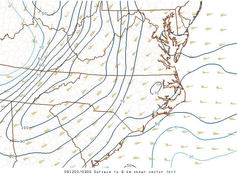
17 0-6km shear

18 SPC Sig Tor effective layer


19 RUC profiles
What is Storm Anticipation (SA)? Using the SPC mesoanalysis fields to anticipate what is likely to occur.
? Using the SPC mesoanalysis fields to anticipate what is likely to occur.") Fisher 2018 What is Storm Anticipation (SA)? Using the SPC mesoanalysis fields to anticipate what is likely to occur. Why do I need it? I have read the SPC outlooks and discussions (part of SA) I have
Fisher 2018 What is Storm Anticipation (SA)? Using the SPC mesoanalysis fields to anticipate what is likely to occur. Why do I need it? I have read the SPC outlooks and discussions (part of SA) I have
4/18/2010. National Weather Service. Severe Weather Forecasting: A Western North Carolina Case Study
 National Weather Service Severe Weather Forecasting: A Western North Carolina Case Study Laurence G. Lee Science and Operations Officer National Weather Service Greer, SC Plus 13 River Forecast Centers
P3.17 THE DEVELOPMENT OF MULTIPLE LOW-LEVEL MESOCYCLONES WITHIN A SUPERCELL. Joshua M. Boustead *1 NOAA/NWS Weather Forecast Office, Topeka, KS
 P3.17 THE DEVELOPMENT OF MULTIPLE LOW-LEVEL MESOCYCLONES WITHIN A SUPERCELL Joshua M. Boustead *1 NOAA/NWS Weather Forecast Office, Topeka, KS Philip N. Schumacher NOAA/NWS Weather Forecaster Office, Sioux
Paul Yura*, Frank Alsheimer, and Joseph Calderone NOAA, National Weather Service Forecast Office, Charleston South Carolina 1.
 7B.8 AN EXAMINATION OF THE SYNOPTIC AND MESOSCALE ENVIRONMENTS INVOLVED IN TORNADO OUTBREAKS FROM HURRICANES FRANCES (2004) AND JEANNE (2004) OVER NORTHEAST COASTAL GEORGIA AND SOUTHERN SOUTH CAROLINA
P12.6 Multiple Modes of Convection in Moderate to High Wind Shear Environments
 P12.6 Multiple Modes of Convection in Moderate to High Wind Shear Environments Adam J. French and Matthew D. Parker North Carolina State University, Raleigh, North Carolina 1. INTRODUCTION A principle
The Father s Day 2002 Severe Weather Outbreak across New York and Western New England
 P 1.5 22nd Conference on Severe Local Storms Hyannis, MA, 4-8 October 2004 The Father s Day 2002 Severe Weather Outbreak across New York and Western New England Thomas A. Wasula NOAA/National Weather Service,
Case Study 3: Dryline in TX and OK 3 May 1999
 Case Study 3: Dryline in TX and OK 3 May 1999 Brandy Lumpkins Department of Atmospheric and Oceanic Sciences University of Wisconsin Madison 8 May 2006 ABSTRACT A massive tornadic outbreak swept across
Severe Weather with a strong cold front: 2-3 April 2006 By Richard H. Grumm National Weather Service Office State College, PA 16803
 Severe Weather with a strong cold front: 2-3 April 2006 By Richard H. Grumm National Weather Service Office State College, PA 16803 1. INTRODUCTION A strong cold front brought severe weather to much of
Anthony A. Rockwood Robert A. Maddox
 Anthony A. Rockwood Robert A. Maddox An unusually intense MCS produced large hail and wind damage in northeast Kansas and northern Missouri during the predawn hours of June 7 th, 1982. Takes a look at
Summary of November Central U.S. Winter Storm By Christopher Hedge
 Summary of November 12-13 2010 Central U.S. Winter Storm By Christopher Hedge Event Overview The first significant snowfall of the 2010-2011 season affected portions of the plains and upper Mississippi
The Thanksgiving 2004 Severe Weather Event across Upstate New York and New England
 P 12.9 23rd Conference on Severe Local Storms Saint Louis, MO, 6-10 November 2006 The Thanksgiving 2004 Severe Weather Event across Upstate New York and New England *Thomas A. Wasula and Kenneth D. LaPenta
Mid Atlantic Severe Event of 1 May 2017 Central Pennsylvania QLCS event By Richard H. Grumm National Weather Service, State College, PA 16803
 1. Overview Mid Atlantic Severe Event of 1 May 2017 Central Pennsylvania QLCS event By Richard H. Grumm National Weather Service, State College, PA 16803 A strong upper-level wave (Fig.1) moving into a
WARM SECTOR TORNADOES WITHOUT DISCERNIBLE SURFACE BOUNDARIES AND WITH MINIMAL DEEP LAYER SHEA
 2.1 WARM SECTOR TORNADOES WITHOUT DISCERNIBLE SURFACE BOUNDARIES AND WITH MINIMAL DEEP LAYER SHEA * Joshua M. Boustead and Philip N. Schumacher National Weaer Service Sioux Falls, SD 1. INTRODUCTION On
SPC Mission Statement. Tornado in Miami, FL Photo: Miami Herald. What is SPC s Responsibility? More SPC Products. SPC Products
 The NOAA/NWS Storm Prediction Center Adapted from a presentation to UNCA atmospheric science students by David Imy SPC Mission Statement SPC exists to protect life and property of the American people through
A LOOK AT TROPICAL STORM GASTON FLOODING IN VIRGINIA
 J12B.4 A LOOK AT TROPICAL STORM GASTON FLOODING IN VIRGINIA John Billet* and Keith Lynch NOAA/NWS Wakefield, VA 1. INTRODUCTION Hurricane Gaston made landfall north of Charleston, SC on Sunday morning
SEVERE LOCAL STORM WARNINGS: CHALLENGES FROM THE 04 MARCH 2004 EVENT. Gregory R. Patrick * and Gary R. Woodall, NOAA/NWS, Fort Worth, TX
 P2.5 SEVERE LOCAL STORM WARNINGS: CHALLENGES FROM THE 04 MARCH 2004 EVENT Gregory R. Patrick * and Gary R. Woodall, NOAA/NWS, Fort Worth, TX 1. INTRODUCTION A powerful low pressure center at 500 hpa moved
The 2015 NWS Spring and Summer Weather Update
 http://weather.gov The 2015 NWS Spring and Summer Weather Update Western North Carolina severe weather climatology Tony Sturey, WCM Greenville/Spartanburg, SC North Carolina Spring and Summer Outlooks
A Detailed Analysis of a Long-Tracked Supercell. Jason T. Martinelli and Andrew Elliott. Fred Glass
 A Detailed Analysis of a Long-Tracked Supercell Jason T. Martinelli and Andrew Elliott Department of Atmospheric Sciences, Creighton University, Omaha, Nebraska Fred Glass National Weather Service Forecast
On the usage of composite parameters in High-Shear, Low-CAPE environments
 P72 On the usage of composite parameters in High-Shear, Low-CAPE environments Keith D. Sherburn* and Matthew D. Parker Department of Marine, Earth, and Atmospheric Sciences, North Carolina State University,
3A.6 ANALYSIS OF DATA FROM THE 2008 SUPER TUESDAY SEVERE WEATHER OUTBREAK: AN ARKANSAS PERSPECTIVE
 3A.6 ANALYSIS OF DATA FROM THE 2008 SUPER TUESDAY SEVERE WEATHER OUTBREAK: AN ARKANSAS PERSPECTIVE Christopher C. Buonanno* John A. Lewis III NOAA/NWS Little Rock AR 1. INTRODUCTION The Super Tuesday Severe
ANSWER KEY. Part I: Synoptic Scale Composite Map. Lab 12 Answer Key. Explorations in Meteorology 54
 ANSWER KEY Part I: Synoptic Scale Composite Map 1. Using Figure 2, locate and highlight, with a black dashed line, the 500-mb trough axis. Also, locate and highlight, with a black zigzag line, the 500-mb
P12.7 THE ROLE OF A SURFACE BOUNDARY AND MULTIPLE CELL-MERGERS IN THE DEVELOPMENT OF THE 21 APRIL 2003 TORNADO IN UPSTATE SOUTH CAROLINA
 P12.7 THE ROLE OF A SURFACE BOUNDARY AND MULTIPLE CELL-MERGERS IN THE DEVELOPMENT OF THE 21 APRIL 2003 TORNADO IN UPSTATE SOUTH CAROLINA 1. INTRODUCTION Bryan McAvoy NOAA/National Weather Service Greer,
P2.5 THE TORNADO OUTBREAK OF 1-2 MARCH 2007 IN THE NATIONAL WEATHER SERVICE TALLAHASSEE FORECAST AREA
 P2.5 THE TORNADO OUTBREAK OF 1-2 MARCH 2007 IN THE NATIONAL WEATHER SERVICE TALLAHASSEE FORECAST AREA Andrew I. Watson* Bryan A. Mroczka J. Parks Camp Jeffery A. Fournier Robert C. Goree NOAA/National
We Had No Warning An Overview of Available Forecast Products Before and During Severe Weather Events
 We Had No Warning An Overview of Available Forecast Products Before and During Severe Weather Events Two main sources for severe weather info NOAA/NWS Storm Prediction Center (SPC) Convective Outlooks
Oakfield, WI Tornado of July 18 th, 1996: "Everything in its Right Place"
 Oakfield, WI Tornado of July 18 th, 1996: "Everything in its Right Place" Arian Sarsalari Department of Atmospheric and Oceanic Sciences, University of Wisconsin Madison ABSTRACT This paper will serve
National Weather Service-Pennsylvania State University Weather Events
 National Weather Service-Pennsylvania State University Weather Events Historic Ohio Valley January Severe weather and Tornado Event by Richard H. Grumm National Weather Service State College PA 16803 and
Type of storm viewed by Spotter A Ordinary, multi-cell thunderstorm. Type of storm viewed by Spotter B Supecell thunderstorm
 ANSWER KEY Part I: Locating Geographical Features 1. The National Weather Service s Storm Prediction Center (www.spc.noaa.gov) has issued a tornado watch on a warm spring day. The watch covers a large
Jonathan M. Davies* Private Meteorologist, Wichita, Kansas
 4.3 RUC Soundings with Cool Season Tornadoes in Small CAPE Settings and the 6 November 2005 Evansville, Indiana Tornado Jonathan M. Davies* Private Meteorologist, Wichita, Kansas 1. Introduction Several
P8.10 AN EXAMINATION OF VARYING SUPERCELL ENVIRONMENTS OVER THE COMPLEX TERRAIN OF THE EASTERN TENNESSEE RIVER VALLEY
 P8.10 AN EXAMINATION OF VARYING SUPERCELL ENVIRONMENTS OVER THE COMPLEX TERRAIN OF THE EASTERN TENNESSEE RIVER VALLEY by David M. Gaffin* and David G. Hotz National Weather Service, Morristown TN 1. INTRODUCTION
Determining Environmental Parameters Most Important for Significant Cool Season Tornadoes across the Gulf Coastal States
 Determining Environmental Parameters Most Important for Significant Cool Season Tornadoes across the Gulf Coastal States Kar retta Venable Jackson State University, Jackson, MS Mentors David Imy NOAA/NWS/NCEP/Storm
Mid-Atlantic Severe Weather Event of 23 June 2015
 Mid-Atlantic Severe Weather Event of 23 June 2015 By Richard H. Grumm National Weather Service State College, PA 1. Overview A widespread severe weather event occurred in the eastern United States on 23
Steve Keighton * and Steve Nogueira NOAA/NWS Blacksburg, VA. Nicole Belk NOAA/NWS Charleston, WV
 P5.17 SYNOPTIC AND MESOSCALE ANALYSIS OF THE 9 AUGUST 2000 APPALACHIAN-CROSSING DERECHOS Steve Keighton * and Steve Nogueira NOAA/NWS Blacksburg, VA Nicole Belk NOAA/NWS Charleston, WV 1. INTRODUCTION
The Oakfield, Wisconsin, Tornado from July Brett Berenz Student at the University of Wisconsin
 The Oakfield, Wisconsin, Tornado from 18-19 July 1996 Brett Berenz Student at the University of Wisconsin Abstract On July 18 th, 1996 an F5 tornado affected the region of Oakfield, Wisconsin. Leading
A DETAILED ANALYSIS OF THE NOCTURNAL QLCS TORNADOES THAT MOVED THROUGH OMAHA, NEBRASKA, ON 8 JUNE 2008
 JP1.10 A DETAILED ANALYSIS OF THE NOCTURNAL QLCS TORNADOES THAT MOVED THROUGH OMAHA, NEBRASKA, ON 8 JUNE 2008 Barbara E. Mayes *1, Jason T. Martinelli #, and Daniel Nietfeld * * National Weather Service
Isolated severe weather and cold air damming 9 November 2005 By Richard H. Grumm National Weather Service Office State College, PA 16801
 Isolated severe weather and cold air damming 9 November 2005 By Richard H. Grumm National Weather Service Office State College, PA 16801 1. INTRODUCTION Two lines of convection moved over the State of
WISCONSIN TORNADO OUTBREAK OF 18 AUGUST 2005: AN EXAMINATION OF THE VIOLA, WISCONSIN TORNADO
 WISCONSIN TORNADO OUTBREAK OF 18 AUGUST 2005: AN EXAMINATION OF THE VIOLA, WISCONSIN TORNADO Charles D. Koch University of Wisconsin Madison AOS 453: Mesoscale Meteorology Professor Greg Tripoli 13 May
Boundary-layer Decoupling Affects on Tornadoes
 Boundary-layer Decoupling Affects on Tornadoes Chris Karstens ABSTRACT The North American low-level jet is known to have substantial impacts on the climatology of central and eastern regions of the United
P12.7 MESOCYCLONE AND RFD INDUCED DAMAGING WINDS OBSERVED IN THE 27 MAY 2004 SOUTHWEST OHIO SUPERCELL
 P12.7 MESOCYCLONE AND RFD INDUCED DAMAGING WINDS OBSERVED IN THE 27 MAY 2004 SOUTHWEST OHIO SUPERCELL John T. DiStefano* National Weather Service Office, Wilmington, Ohio 1. INTRODUCTION During the early
J. Brad McGavock*, Robert B. Darby, Steven F. Piltz
 P1.9 Interactive Mesoscale Analysis Utilized in Assisting Local Decision Makers: A Review of the 24 March 2005 Supercell 1. INTRODUCTION J. Brad McGavock*, Robert B. Darby, Steven F. Piltz Severe weather
Ki-Hong Min 1*, Seonhee Choo 2, and Gyuwon Lee 1, and Kyung-Eak Kim 1,3
 Ki-Hong Min 1*, Seonhee Choo 2, and Gyuwon Lee 1, and Kyung-Eak Kim 1,3 1 School of Earth System Sciences, Major in Atmospheric Science, Kyungpook National University, Daegu, South Korea 2 Forecast Technology
Multi-day severe event of May 2013
 Abstract: Multi-day severe event of 18-22 May 2013 By Richard H. Grumm and Charles Ross National Weather Service State College, PA A relatively slow moving Trough over the western United States and a ridge
P10.4 EXAMINATION OF TORNADIC AND NON-TORNADIC SUPERCELLS IN SOUTHWEST VIRGINIA ON 28 APRIL 2002
 P10.4 EXAMINATION OF TORNADIC AND NON-TORNADIC SUPERCELLS IN SOUTHWEST VIRGINIA ON 28 APRIL 2002 Steve Keighton*, Kenneth Kostura, and Chris Liscinsky NOAA/National Weather Service Blacksburg, VA 1. INTRODUCTION
Thanksgiving Snow and Arctic Front 25 November 2005 By Richard H. Grumm National Weather Service State College, PA 16801
 Thanksgiving Snow and Arctic Front 25 November 2005 By Richard H. Grumm National Weather Service State College, PA 16801 1. INTRODUCTION An approaching arctic front brought light snow to most of western
Joshua M. Boustead *1, and Barbara E. Mayes NOAA/NWS WFO Omaha/Valley, NE. William Gargan, George Phillips, and Jared Leighton NOAA/NWS WFO Topeka, KS
 7B.3 Composite Analysis of Environmental Conditions Favorable for Significant Tornadoes across Eastern Kansas Joshua M. Boustead *1, and Barbara E. Mayes NOAA/NWS WFO Omaha/Valley, NE William Gargan, George
A COMPREHENSIVE 5-YEAR SEVERE STORM ENVIRONMENT CLIMATOLOGY FOR THE CONTINENTAL UNITED STATES 3. RESULTS
 16A.4 A COMPREHENSIVE 5-YEAR SEVERE STORM ENVIRONMENT CLIMATOLOGY FOR THE CONTINENTAL UNITED STATES Russell S. Schneider 1 and Andrew R. Dean 1,2 1 DOC/NOAA/NWS/NCEP Storm Prediction Center 2 OU-NOAA Cooperative
P1.3 Tornadoes in a Deceptively Small CAPE Environment: The 4/20/04 Outbreak in Illinois and Indiana
 P1.3 Tornadoes in a Deceptively Small CAPE Environment: The 4/20/04 Outbreak in Illinois and Indiana Albert E. Pietrycha* Jonathan M. Davies #, Mark Ratzer*, and Paul Merzlock* *National Weather Service,
P4.479 A DETAILED ANALYSIS OF SPC HIGH RISK OUTLOOKS,
 P4.479 A DETAILED ANALYSIS OF SPC HIGH RISK OUTLOOKS, 2003-2009 Jason M. Davis*, Andrew R. Dean 2, and Jared L. Guyer 2 Valparaiso University, Valparaiso, IN 2 NOAA/NWS Storm Prediction Center, Norman,
Severe Weather Event of 13 July 2014
 Severe Weather Event of 13 July 2014 By Richard H. Grumm and Elyse M. Colbert National Weather Service State College, PA 1. Overview Severe weather affected the eastern United States (Fig. 1) from northwestern
1st Tornado Photograph
 Lecture 26 Part II Tornados Environment Storm Structure Life Cycle Source of Spin Forecasting Climatology Damage Marilee Thomas of Beaver City, NE took this photograph of her daughter Audra about two miles
The Severe Weather Event of 7 August 2013 By Richard H. Grumm and Bruce Budd National Weather Service State College, PA 1. INTRODUCTION and Overview
 The Severe Weather Event of 7 August 2013 By Richard H. Grumm and Bruce Budd National Weather Service State College, PA 1. INTRODUCTION and Overview A fast moving short-wave (Fig. 1) with -1σ 500 hpa height
12.1 PRELIMINARY EVALUATION OF A PARAMETER TO FORECAST ENVIRONMENTS CONDUCIVE TO NON-MESOCYCLONE TORNADOGENESIS
 12.1 PRELIMINARY EVALUATION OF A PARAMETER TO FORECAST ENVIRONMENTS CONDUCIVE TO NON-MESOCYCLONE TORNADOGENESIS Dan A. Baumgardt* NOAA/National Weather Service La Crosse, Wisconsin Kenneth Cook NOAA/National
Heavy Rainfall Event of June 2013
 Heavy Rainfall Event of 10-11 June 2013 By Richard H. Grumm National Weather Service State College, PA 1. Overview A 500 hpa short-wave moved over the eastern United States (Fig. 1) brought a surge of
1 of 7 Thunderstorm Notes by Paul Sirvatka College of DuPage Meteorology. Thunderstorms
 1 of 7 Thunderstorm Notes by Paul Sirvatka College of DuPage Meteorology Thunderstorms There are three types of thunderstorms: single-cell (or air mass) multicell (cluster or squall line) supercell Although
The Greensburg, KS Tornado
 J2.4 The Greensburg, KS Tornado Daniel McCarthy NOAA Storm Prediction Center Norman, OK Larry Ruthi and Jeff Hutton NWS Weather Forecast Office Dodge City, KS 1. Background The tornado that moved through
Weather Systems III: Thunderstorms and Twisters
 Weather Systems III: Thunderstorms and Twisters Review 1. Definition of airmasses? Bergeron classification of air masses 2. Surface weather analysis: Station model, wind speed code, present weather 3.
TROPICAL STORM HARVEY BRIEFING
 TROPICAL STORM HARVEY BRIEFING 10:00 AM CDT Sunday, August 27, 2017 Prepared by: NWS LIX NWSNewOrleans www.weather.gov/neworleans Situation Overview New Information Tropical Storm Winds 40mph Immediate
Hurricane and Tropical Cyclone Tornado Environments from RUC Proximity Soundings
 P8.1 Hurricane and Tropical Cyclone Tornado Environments from RUC Proximity Soundings Jonathan M. Davies* Private Meteorologist, Wichita, Kansas 1. Introduction Studies such as those by McCaul (1991, 1996)
1. INTRODUCTION GSP Dr, Greer, SC tropical cyclones. 1 This study did not include tornadoes associated with
 4.5 OBSERVATIONS OF A NON-SUPERCELL TORNADIC THUNDERSTORM FROM A TERMINAL DOPPLER WEATHER RADAR Justin D. Lane * and Patrick D. Moore NOAA/National Weather Service Greer, SC 1. INTRODUCTION Despite numerous
Investigation of the Arizona Severe Weather Event of August 8 th, 1997
 Investigation of the Arizona Severe Weather Event of August 8 th, 1997 Tim Hollfelder May 10 th, 2006 Abstract Synoptic scale forcings were very weak for these thunderstorms on August 7-8, 1997 over the
ALLEY CATS: HOW EL NIÑO INFLUENCES TORNADO ALLEY AND THE THREAT OF CATASTROPHES
 ALLEY CATS: HOW EL NIÑO INFLUENCES TORNADO ALLEY AND THE THREAT OF CATASTROPHES Kevin Van Leer - Sr. Product Manager, Model Product Management National Tornado Summit - Tuesday, March 1 st, 2016 1 EL NIÑO/SOUTHERN
P9.6 SEVERE THUNDERSTORMS OF 3 APRIL 2004: AN EXAMINATION OF A DRY-SEASON SEVERE WEATHER EVENT IN THE BORDERLAND
 P9.6 SEVERE THUNDERSTORMS OF 3 APRIL 2004: AN EXAMINATION OF A DRY-SEASON SEVERE WEATHER EVENT IN THE BORDERLAND 1. INTRODUCTION Michael P. Hardiman Joseph A. Rogash National Weather Service, Santa Teresa,
THE SYNOPTIC ENVIRONMENT OF THE 11 APRIL 2001 CENTRAL PLAINS TORNADO OUTBREAK VIEWED IN THREE DIMENSIONS
 P1.1 THE SYNOPTIC ENVIRONMENT OF THE 11 APRIL 2001 CENTRAL PLAINS TORNADO OUTBREAK VIEWED IN THREE DIMENSIONS Daniel D. Nietfeld * NOAA/NWS/WFO Omaha/Valley, NE 1. INTRODUCTION A powerful low pressure
Mature Tornado. Tornado funnel and debris cloud. Mature Tornado
 Mature Tornado Tornado funnel and debris cloud 43 Mature Tornado 44 Tornado in Final Rope Stage 45 Source of Spin 46 Source of Spin Updraft Stretches Rotating Column 47 Simulation of Tornado Formation
The Integration of WRF Model Forecasts for Mesoscale Convective Systems Interacting with the Mountains of Western North Carolina
 Proceedings of The National Conference On Undergraduate Research (NCUR) 2006 The University of North Carolina at Asheville Asheville, North Carolina April 6-8, 2006 The Integration of WRF Model Forecasts
AN INVESTIGATION OF THE SIGNIFICANT TORNADO OUTBREAK IN SOUTHERN SOUTH CAROLINA AND NORTH COASTAL GEORGIA ON MARCH 15, 2008
 P3.6 AN INVESTIGATION OF THE SIGNIFICANT TORNADO OUTBREAK IN SOUTHERN SOUTH CAROLINA AND NORTH COASTAL GEORGIA ON MARCH 15, 2008 Frank W. Alsheimer*, Robert Bright, Jonathon Jelsema, Wendy Moen, John Quagliariello,
Impacts of the April 2013 Mean trough over central North America
 Impacts of the April 2013 Mean trough over central North America By Richard H. Grumm National Weather Service State College, PA Abstract: The mean 500 hpa flow over North America featured a trough over
Summary of High Wind Event of 7 March 2004
 Summary of High Wind Event of 7 March 2004 This event was characterized by a very strong jet streak that developed over North Carolina by 00 UTC 8 March, as seen in the Eta model analysis at 300 mb, with
Major Hurricane Earl
 Major Hurricane Earl Advisory 32 North Carolina Threat Assessment Prepared at: 8 AM Thursday September 2, 2010 Hurricane and Tropical Storm Warnings in effect for the North Carolina Coast and Sounds. NWS
P9.5 MESOSCALE ASPECTS OF THE 11 MARCH 2006 SEVERE WEATHER OUTBREAK. Fred H. Glass NOAA/National Weather Service St.
 P9.5 MESOSCALE ASPECTS OF THE 11 MARCH 2006 SEVERE WEATHER OUTBREAK Fred H. Glass NOAA/National Weather Service St. Charles, Missouri 1. INTRODUCTION During the evening hours of 11 March 2006, a series
MET Lecture 29 Tornadoes IV
 MET 4300 Lecture 29 Tornadoes IV Outline Definition, life cycle, & climatology of tornadoes Tornado formation within supercells Tornado formation within nonsupercell thunderstorms Fujita scale Tornado
Pennsylvania Severe Weather of September 2016
 Pennsylvania Severe Weather of September 2016 By Richard H. Grumm National Weather Service State College, PA 1. Overview September 2016 was a relatively quiet month for severe weather across most of the
June 7, 2008 Northeast Illinois Tornado Outbreak: Applying to Fundamentals in Storm Spotting
 June 7, 2008 Northeast Illinois Tornado Outbreak: Applying to Fundamentals in Storm Spotting Near Manhattan, IL Richton Park, IL Ricky Castro National Weather Service Chicago/Romeoville, IL Tornado Crossing
Investigating the Environment of the Indiana and Ohio Tornado Outbreak of 24 August 2016 Using a WRF Model Simulation 1.
 Investigating the Environment of the Indiana and Ohio Tornado Outbreak of 24 August 2016 Using a WRF Model Simulation Kevin Gray and Jeffrey Frame Department of Atmospheric Sciences, University of Illinois
Talking points for Water Vapor Imagery Analysis for Severe Thunderstorm Forecasting.
 Talking points for Water Vapor Imagery Analysis for Severe Thunderstorm Forecasting. 1. Title. 2. Learning objectives. These are the topics we ll consider during this training session, the goal of the
severe VOLUME 5, NUMBER 1, FEBRUARY 1980
 severe VOLUME 5, NUMBER 1, FEBRUARY 1980 TORNADIC THUNDERSTORM DEVELOPMENT IN WEST TEXAS 27 MAY 1978 by Richard E. Peterson Atmospheric Science Group Texas University Lubbock, TX and Alan Johnson National
POLARIMETRIC RADAR OBSERVATION OF A TORNADO AT C-BAND
 P2.21 POLARIMETRIC RADAR OBSERVATION OF A TORNADO AT C-BAND Raquel Evaristo, Teresa Bals-Elsholz, Adam Stepanek, Bart Wolf, Kevin Goebbert, Anthony Lyza, Travis Elless Valparaiso University, Valparaiso,
High Impact Weather Event Week
 http://www.essl.org/ www.essl.org/eswd/ High Impact Weather Event Week A recipe for Thunderstorms For EUMETRAIN Speaker: Helge Tuschy http://www.estofex.org/ Short vita studied Meteorology / Geophysics
Cold frontal Rainband and Mid-Atlantic Severe Weather Event 28 September 2006 by Richard H. Grumm And Ron Holmes
 Cold frontal Rainband and Mid-Atlantic Severe Weather Event 28 September 2006 by Richard H. Grumm And Ron Holmes 1. INTRODUCTION A strong cold front moved across central Pennsylvania and the Mid-Atlantic
Chapter 14 Thunderstorm Fundamentals
 Chapter overview: Thunderstorm appearance Thunderstorm cells and evolution Thunderstorm types and organization o Single cell thunderstorms o Multicell thunderstorms o Orographic thunderstorms o Severe
IWT Scenario 2 Integrated Warning Team Workshop National Weather Service Albany, NY October 31, 2014
 IWT Scenario 2 Integrated Warning Team Workshop National Weather Service Albany, NY October 31, 2014 09 10 11 12 13 Scenario 2 Timeline December 9-13 Tue Wed Thu Fri Sat Tue, Dec. 9 @ 5 am 2014 2014 2014
1. INTRODUCTION * Figure 1. National Weather Service Storm Prediction Center (SPC) storm reports for December 1, 2006.
 storm reports for December 1, 2006.") P1.14 FORECAST ISSUES RELATED TO THE UNPRECEDENTED SEVERE AND HIGH WIND EVENT OF DECEMBER 2006 by Greg A. DeVoir* and Richard H. Grumm National Weather Service Office State College, PA 16803 1. INTRODUCTION
P1.14 FORECAST ISSUES RELATED TO THE UNPRECEDENTED SEVERE AND HIGH WIND EVENT OF DECEMBER 2006 by Greg A. DeVoir* and Richard H. Grumm National Weather Service Office State College, PA 16803 1. INTRODUCTION
July24th, 2008 New Hampshire tornado. Hunter Straus. University of Wisconsin department of Atmospheric and Oceanic Sciences Madison, WI ABSTRACT
 July24th, 2008 New Hampshire tornado Hunter Straus University of Wisconsin department of Atmospheric and Oceanic Sciences Madison, WI 53715 ABSTRACT On July 24 th, 2008 at approximately 1530Z, an EF-2
The Long-lived eastern US tornadic supercell of 20 July 2017
 1. Overview The Long-lived eastern US tornadic supercell of 20 July 2017 By Richard H. Grumm and Elissa A Smith National Weather Service State College, PA A long lived supercell developed near the eastern
Advanced Spotter Training: Anticipating Severe Weather Threats. Professor Paul Sirvatka College of DuPage Meteorology
 Advanced Spotter Training: Anticipating Severe Weather Threats College of DuPage Meteorology Preparing for Severe Weather Preparedness involves understanding the probable and potential threats. Understanding
David G. Biggar. National Weather Service Forecast Office, Jackson, Mississippi
 A CASE STUDY OF A POSITIVE STRIKE DOMINATED SUPERCELL THUNDERSTORM THAT PRODUCED AN F2 TORNADO AFTER UNDERGOING A SIGNIFICANT CLOUD-TO-GROUND LIGHTNING POLARITY SHIFT Abstract David G. Biggar National
Severe Freezing Rain in Slovenia
 Severe Freezing Rain in Slovenia Janez Markosek, Environmental Agency, Slovenia Introduction At the end of January and at the beginning of February 2014, severe and long-lasting freezing rain affected
P12.14 A SOUNDING-DERIVED CLIMATOLOGY OF SIGNIFICANT TORNADO EVENTS IN THE GREENVILLE-SPARTANBURG, SOUTH CAROLINA COUNTY WARNING AREA ( )
") P12.14 A SOUNDING-DERIVED CIMATOOGY OF SIGNIFICANT TORNADO EVENTS IN THE GREENVIE-SPARTANBURG, SOUTH CAROINA COUNTY WARNING AREA (1948-26) Justin D. ane* NOAA/National Weather Service Greer, South Carolina
P12.14 A SOUNDING-DERIVED CIMATOOGY OF SIGNIFICANT TORNADO EVENTS IN THE GREENVIE-SPARTANBURG, SOUTH CAROINA COUNTY WARNING AREA (1948-26) Justin D. ane* NOAA/National Weather Service Greer, South Carolina
WEATHER NOTIFICATION STATEMENT
 WEATHER NOTIFICATION STATEMENT NEW DATA SHOWS SNOWSTORM THREAT FOR JAN 13-14 LOOKS MUCH HEAVIER BIGGER COVERAGE northwest NC (ice) ALL OF VA (Except Hampton Roads) all of MD/ DEL eastern southern PA southern
Significant Tornadoes in the Northern Plains: An Environmental and Pattern-Based Climatological Risk Assessment
 Significant Tornadoes in the Northern Plains: An Environmental and Pattern-Based Climatological Risk Assessment Chauncy J. Schultz NOAA/NWS Bismarck, ND Significant tornadoes have occurred in all corners
contact with ground for 1 hour plus, starting 1500 MDT moved N., covered about 37 km width varied m
 Goal for today: Finish Ch. 11 Lightning, Thunder & Tornadoes 16 Nov., 2011 Edmonton tornado 31 July 1987 contact with ground for 1 hour plus, starting 1500 MDT moved N., covered about 37 km width varied
End of heat-event severe event of 7 July 2012
 End of heat-event severe event of 7 July 2012 Richard H. Grumm And Elyse Colbert National Weather Service Office State College, PA 16803 1. Overview A widespread severe weather event affected Pennsylvania
Joshua M. Boustead *1 NOAA/NWS WFO Omaha/Valley, NE. Philip N. Schumacher NOAA/NWS WFO Sioux Falls, SD
 11B.2 Influence of Diabatic Potential Vorticity Anomalies upon Warm Conveyor Belt Flow. Part II: 3-5 January 2005 Joshua M. Boustead *1 NOAA/NWS WFO Omaha/Valley, NE Philip N. Schumacher NOAA/NWS WFO Sioux
Tropical Storm Ana. Created 6:00 AM Sun May 10, 2015 John Cole Warning Coordination Meteorologist
 Tropical Storm Ana Threat Assessment for Eastern North Carolina Created 6:00 AM Sun May 10, 2015 John Cole Warning Coordination Meteorologist John.cole@noaa.gov National Weather Service Newport/Morehead
10/21/2012. Chapter 10 Thunderstorms. Part II. Growth and Development of ordinary Cell Thunderstorms Thunderstorm Electrification.
 Chapter 10 Thunderstorms Part I Growth and Development of ordinary Cell Thunderstorms Thunderstorm Electrification Tornadoes Part II Simplified model depicting the life cycle of an ordinary thunderstorm
Boundary Influences on the 7 July 2008 Tornado Event
 National Weather Association, Electronic Journal of Operational Meteorology, 2009-EJ8 Boundary Influences on the 7 July 2008 Tornado Event CHAUNCY J. SCHULTZ National Weather Service, North Platte, Nebraska
P1.15 The May 26-27, 2010 Eastern New York and Western New England Backdoor Cold Front Severe Weather Event
 P1.15 The May 26-27, 2010 Eastern New York and Western New England Backdoor Cold Front Severe Weather Event Thomas A. Wasula*, Brian J. Frugis, and Neil A. Stuart NOAA/National Weather Service, Weather
Severe Thunderstorms. MET 200 Lecture 24 Flooding in Hawaii and Intro to Severe Thunderstorms. MET 200 Lecture 24 Severe Thunderstorms.
 MET 200 Lecture 24 Severe Thunderstorms Damage Swath 1 2 MET 200 Lecture 24 Flooding in Hawaii and Intro to Severe Thunderstorms Severe Thunderstorms Kona Lows Cause more flash floods in Hawaii than any
Tornadoes. tornado: a violently rotating column of air
 Tornadoes tornado: a violently rotating column of air Tornadoes What is the typical size of a tornado? What are typical wind speeds for a tornado? Five-stage life cycle of a tornado Dust Swirl Stage Tornado
Custom Weather Forecast
 1 of 23 Custom Weather Forecast 2018 Chicago Yacht Club s Race To Mackinac- Cruising Division Disclaimer: The user assumes all risk related to the use of this Custom Weather Forecast. The crew of the participating
TFS WEATHER BRIEF. Monday, March 25
 TFS WEATHER BRIEF Monday, March 25 Review: The leading edge of cooler and drier air was pushing through Central and East TX this morning. A few lingering thunderstorms were in progress south of I-20 in