What is Storm Anticipation (SA)? Using the SPC mesoanalysis fields to anticipate what is likely to occur.
|
|
|
- Amberlynn McCarthy
- 5 years ago
- Views:
Transcription

1 Fisher 2018
2 What is Storm Anticipation (SA)? Using the SPC mesoanalysis fields to anticipate what is likely to occur. Why do I need it? I have read the SPC outlooks and discussions (part of SA) I have read the LOT outlooks and discussions (part of SA) SPC has issued a watch Our weather operation is up and running Life is good, I can sit back now and react to the weather. NO! NO! NO! NO! NO! You never want to react to the weather. You want to be proactive, thinking about storm anticipation, thinking about what is most likely to occur. Making the correct decisions based on science.

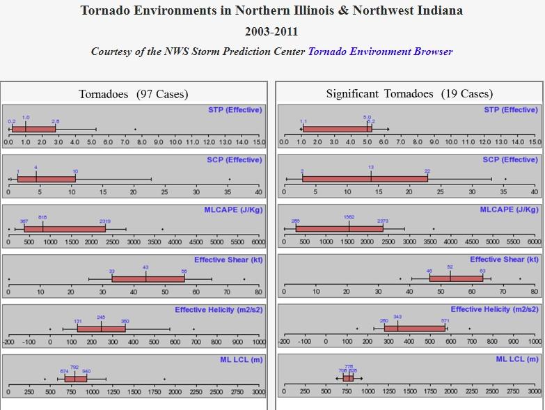
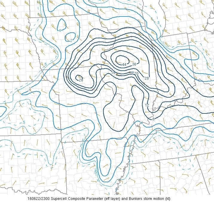
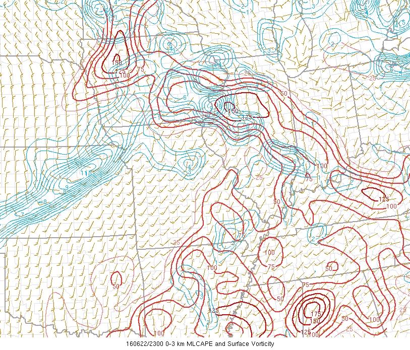
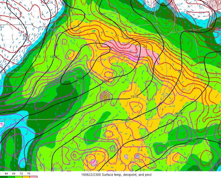
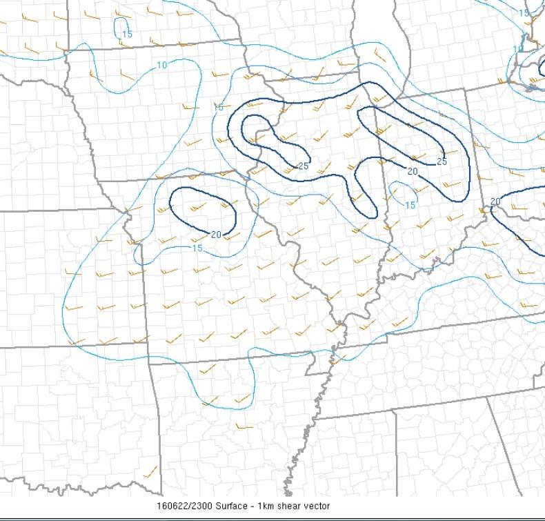
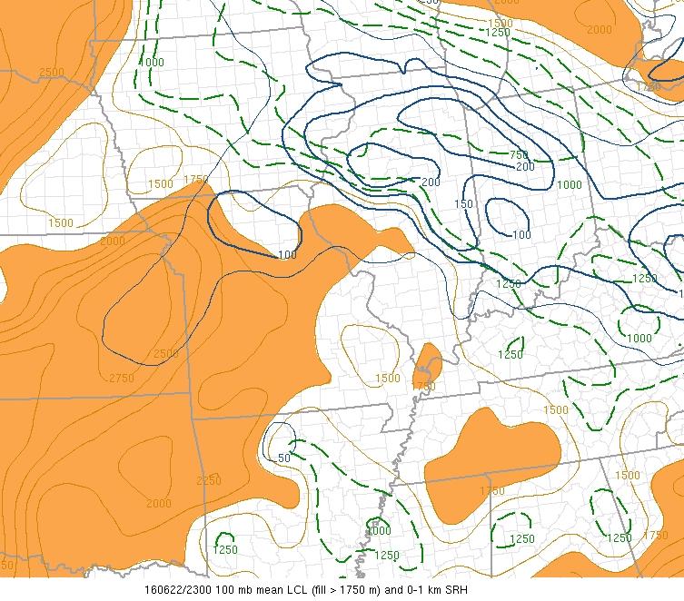
3 This table is the reason for SA. Sixty+ years of weather reality. SA tells you the most likely reality of the day.

4
5
6

7

8
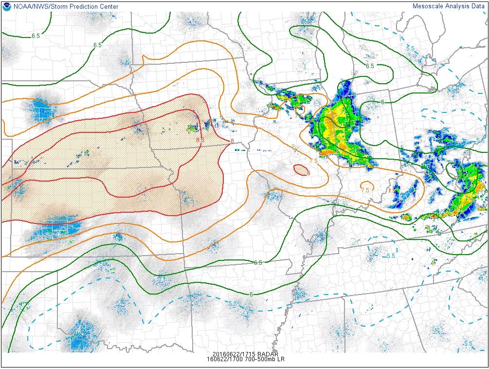
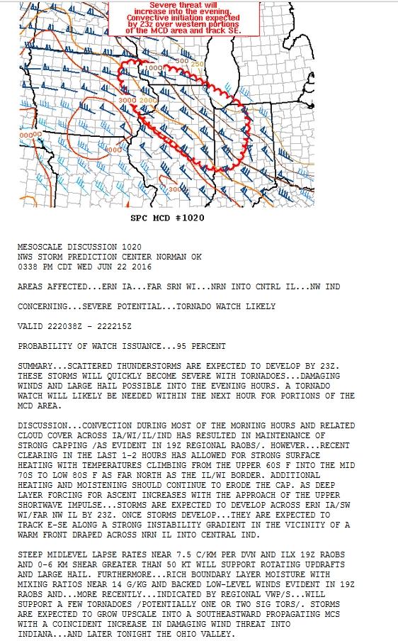
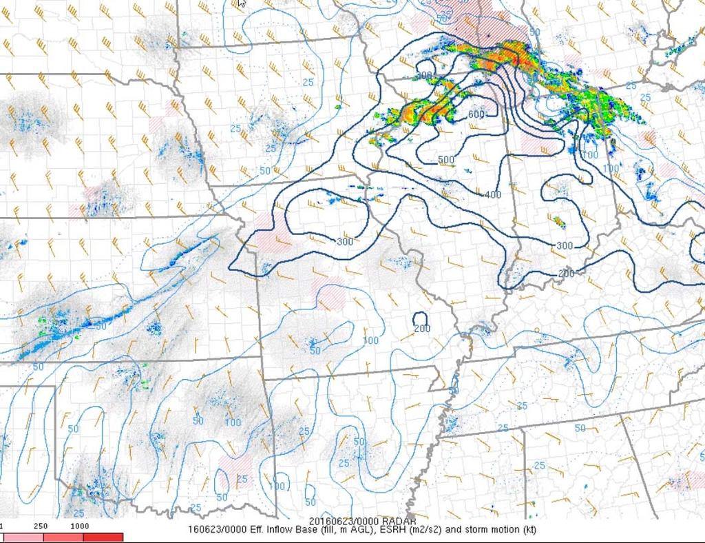
9 ...SUMMARY... WIDESPREAD DAMAGING WIND GUSTS WITH SOME GREATER THAN 70 MILES PER HOUR ALONG WITH TORNADOES AND ISOLATED LARGE HAIL ARE EXPECTED THIS AFTERNOON AND EVENING FROM NORTHEAST IOWA INTO EXTREME SOUTHERN WISCONSIN...NORTHERN ILLINOIS...SOUTHWEST LOWER MICHIGAN...NORTHERN TO CENTRAL INDIANA AND PARTS OF WESTERN OHIO. A WIND DAMAGE THREAT MAY ALSO AFFECT THE UPPER OHIO VALLEY AND CENTRAL AND SOUTHERN APPALACHIANS....UPPER MS VALLEY/MIDWEST/OH VALLEY TO APPALACHIANS... WATER VAPOR IMAGERY FEATURES AN EAST/SOUTHEASTWARD-MOVING LOW-AMPLITUDE SHORTWAVE TROUGH/RELATED SPEED MAX OVER SOUTHERN MANITOBA/NORTHERN ND AT LATE MORNING...WITH THIS IMPULSE EXPECTED TO REACH THE UPPER GREAT LAKES THIS EVENING. AHEAD OF THIS SYSTEM...12Z UPPER-AIR ANALYSIS FEATURES A SEASONALLY VERY STRONG BELT OF 50+ KT WEST-NORTHWESTERLY MID-LEVEL WINDS OVER THE NORTH-CENTRAL/NORTHEAST CONUS...AS FAR SOUTH AS THE MIDDLE MO VALLEY AND OH RIVER/CENTRAL APPALACHIANS. SCATTERED SHOWERS/NON-SEVERE THUNDERSTORMS CONTINUE LATE THIS MORNING ALONG AND NORTHEAST OF WARM FRONT THAT EXTENDS FROM SOUTHEAST IA INTO CENTRAL IL AND SOUTHERN INDIANA. WHILE THE CONTINUED PERSISTENCE OF THIS CONVECTION/RELATED CLOUD CASTS SOME UNCERTAINTY ON ITS EFFECTIVE SPATIAL LOCATION/TIMING...THE WARM FRONT WILL CONTINUE A GENERAL NORTH-NORTHEASTWARD ADVANCEMENT TODAY AS A SURFACE LOW CURRENTLY OVER EASTERN NEB DEVELOPS EASTWARD TOWARD EASTERN IA BY EARLY EVENING. MORNING UPPER-AIR DATA AND RECENT SURFACE ANALYSIS/TRENDS SUGGEST THAT AN INCREASINGLY MOIST AIR MASS /CHARACTERIZED BY AROUND 70F SURFACE DEWPOINTS AND 1.7+ INCH PRECIPITABLE WATER VALUES/ WILL DEVELOP NORTHEASTWARD ACROSS THE REGION IN TANDEM WITH THE PROGRESSION OF THE WARM FRONT. WHILE MID-LEVEL LAPSE RATES WERE NOT PARTICULARLY STEEP IN MOST 12Z REGIONAL OBSERVATIONS...AN EASTWARD-EXPANDING ELEVATED MIXED LAYER /OMAHA 12Z OBSERVED SOUNDING/ WILL CONTRIBUTE TO STRONG BUOYANCY /3000+ J PER KG MLCAPE/ BY LATE AFTERNOON PARTICULARLY FROM EASTERN IA INTO IL AND CENTRAL/SOUTHERN INDIANA. CONSIDERABLE INSTABILITY AND SIGNIFICANTLY STRONG VERTICAL SHEAR /50-70 KT EFFECTIVE/ NEAR AND SOUTH OF THE OUTFLOW/DIFFERENTIAL HEATING-INFLUENCED WARM FRONT WILL SUPPORT INITIAL SUPERCELLS CAPABLE OF LARGE HAIL AND TORNADOES...A FEW OF WHICH COULD BE SIGNIFICANT /EF2+/. THIS INITIAL SUPERCELLULAR DEVELOPMENT CURRENTLY APPEARS MOST PROBABLE ACROSS NORTHERN IL/FAR EASTERN IA AND POSSIBLY ADJACENT EXTREME SOUTHERN WI BY MID/LATE AFTERNOON NEAR/JUST AHEAD OF THE SURFACE LOW AND NEARBY WARM FRONT. THESE STORMS SHOULD EVENTUALLY GROW UPSCALE INTO A FAST-MOVING QUASI-LINEAR MCS...POTENTIALLY WITH A DERECHO-RELATED SIGNIFICANT SWATH OF WIND DAMAGE EVOLVING EAST-SOUTHEASTWARD THROUGH THE EVENING /AND POTENTIALLY CONTINUING INTO THE OVERNIGHT/. THE DAMAGING WIND POTENTIAL MAY REACH THE OH RIVER/CENTRAL APPALACHIANS LATE TONIGHT.
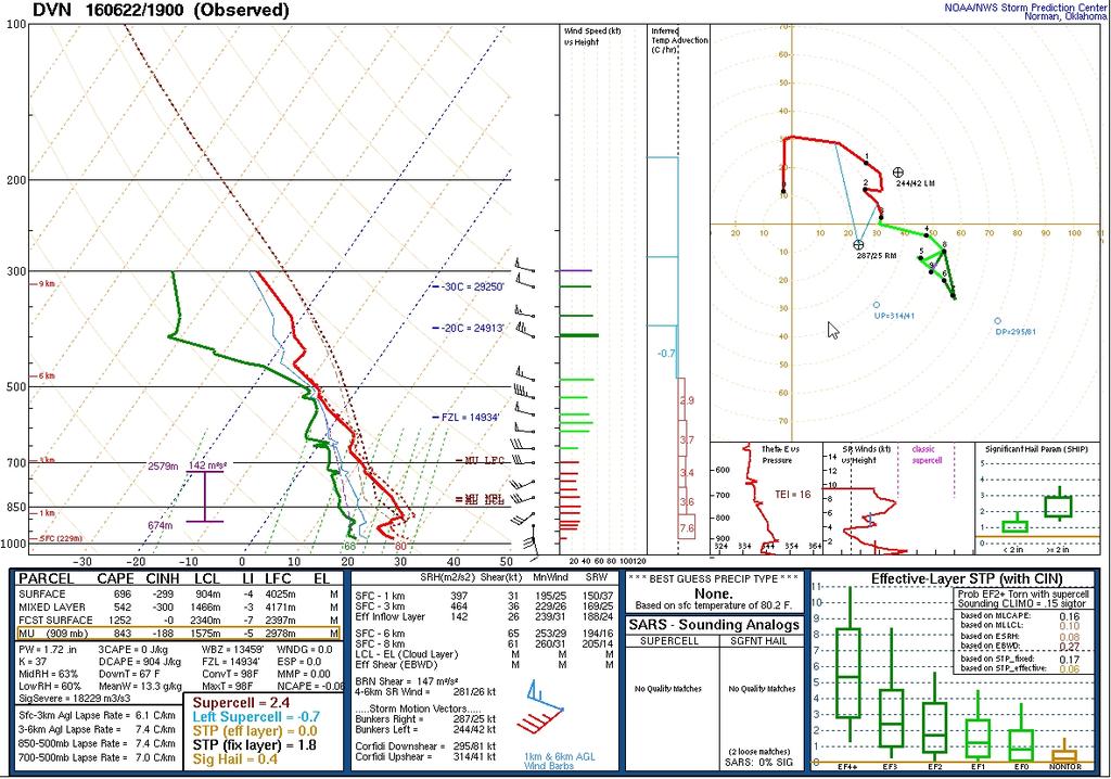
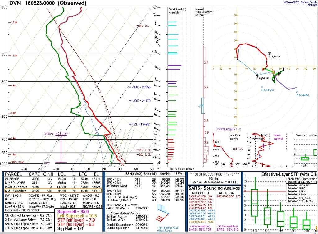
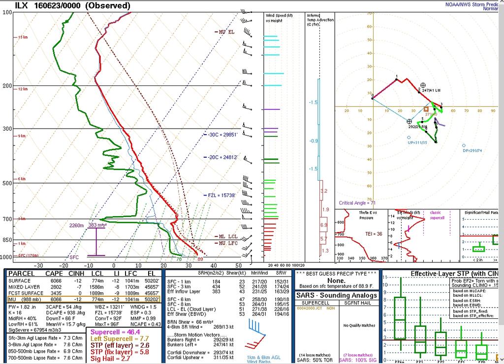
10 ...UPPER MS VALLEY EWD ACROSS THE OH VALLEY... RECENT SURFACE ANALYSIS PLACES THE SURFACE LOW OVER W-CNTRL IA WITH A WEAK INVERTED TROUGH EXTENDING NWD TO ANOTHER LOW NEAR THE ND/SD/MN BORDER INTERSECTION. WARM FRONT EXTENDS FROM THE W-CNTRL IA LOW ENEWD INTO FAR NE IA AND THEN SEWD ACROSS CNTRL IL TO NEAR CMI IN E-CNTRL IL. THIS BOUNDARY HAS BEEN REINFORCED BY DIFFERENTIAL HEATING WITH CLEAR SKIES AND TEMPERATURES IN 80S TO ITS SOUTH WHILE PARTLY TO MOSTLY CLOUDY AND TEMPERATURES IN THE MID 70S TO ITS NORTH. THIS BOUNDARY IS EXPECTED TO MOVE GRADUALLY NEWD OVER THE NEXT FEW HOURS AND TO ACT AS THE NRN DELIMITER OF THE MORE SUBSTANTIAL SVR RISK. 19Z SOUNDING FROM ILX SAMPLED 13 DEG C AT 700 MB AND THE RESULTING CAP SHOULD LIMIT CONVECTIVE POTENTIAL SOUTH AND WEST OF CNTRL IL WITH NO NEED TO EXPAND ANY SEVERE PROBABILITIES SWWD. 19Z SOUNDING FROM DVN SAMPLED FAIRLY STEEP MID-LEVEL LAPSE RATES BUT SIGNIFICANT WARMING AROUND 850 MB /ABOUT 5 DEG C SINCE 12Z/ HAS KEPT CONVECTIVE-INHIBITION IN PLACE. CONTINUED WARMING AND MOISTENING ARE ANTICIPATED HERE AS THE AIRMASS TO THE SW /CHARACTERIZED BY TEMPERATURES IN THE LOW 90S AND DEWPOINTS IN THE LOW 70S/ CONTINUES TO ADVECT NEWD. FORCING FOR ASCENT ASSOCIATED WITH THE APPROACHING SURFACE LOW COMBINED WITH THE ANTICIPATED AIRMASS MODIFICATION IS STILL EXPECTED TO RESULT IN CONVECTIVE INITIATION IN THE VICINITY OF CID/DVN. ONCE THIS OCCURS THE ENVIRONMENT WILL BE VERY SUPPORTIVE FOR INITIAL SUPERCELLS CAPABLE OF ALL HAZARDS /INCLUDING A TORNADO OR TWO/. QUICK UPSCALE GROWTH INTO A LINEAR MCS IS STILL ANTICIPATED WITH A DAMAGING WIND THREAT EXTENDING ACROSS MUCH OF THE OH VALLEY. THIS SCENARIO MATCHES PREVIOUS OUTLOOK THINKING WELL AND NO CHANGES WERE MADE TO THE OUTLOOK ACROSS THIS REGION.

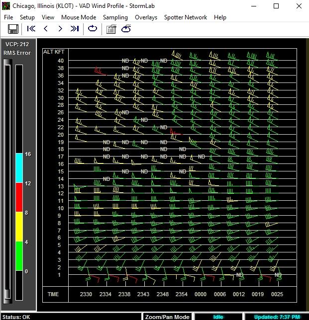
11 11:07 a.m.
12


13


14

15 2:30 p.m.

16

17

18 5:30 p.m.

19

20 5:53 p.m.

21
22

23
24
25
26

27

28
29
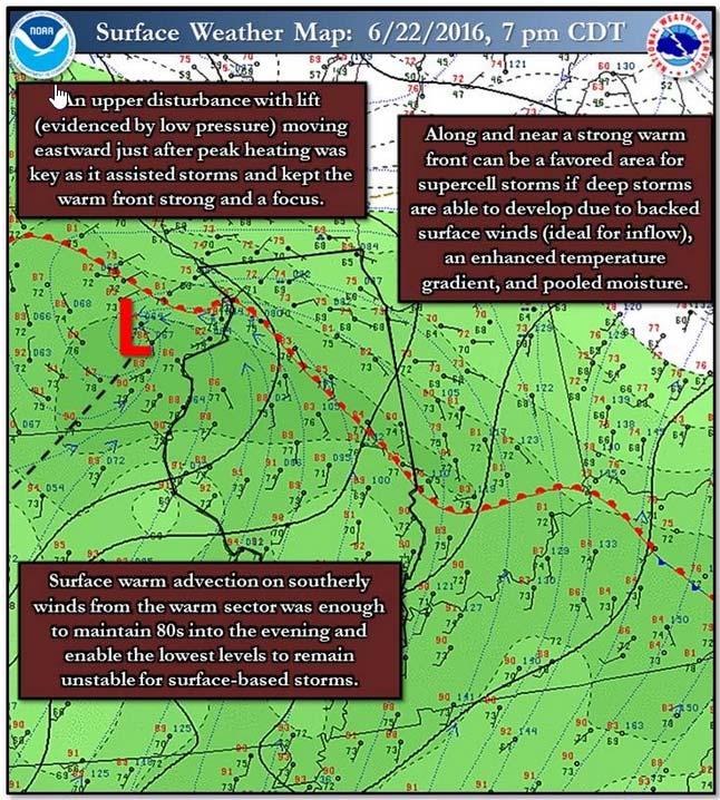
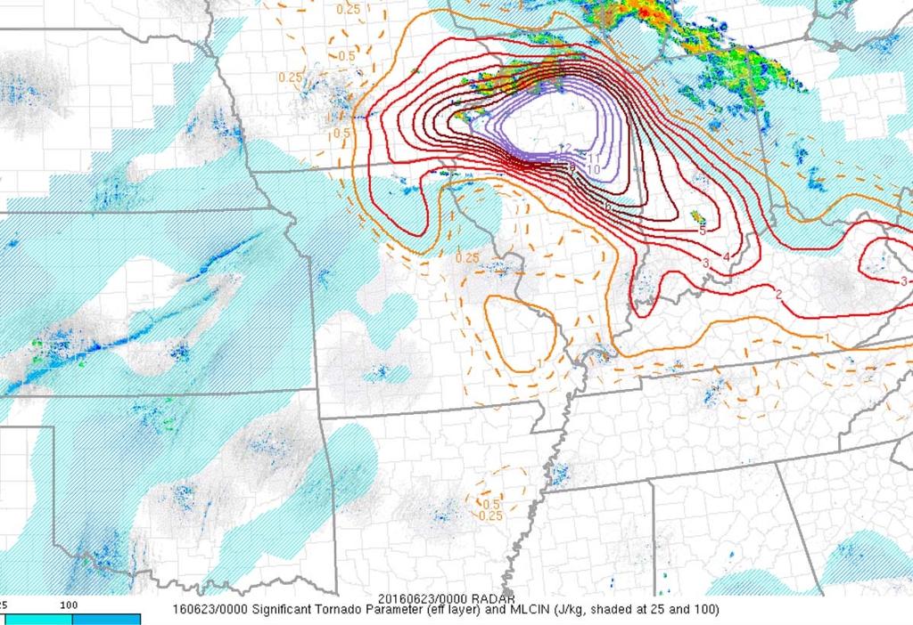
30 The results of my storm anticipation, what am I expecting as a most likely severe weather outbreak? Most concentrated severe storms near the warm front Long lasting supercells easily of 3 4 hours Large hail 2+ inches Supercells to produce multiple tornadoes Likely EF2 EF3 tornadoes Immediate Chicago area in the cool stable air, no tornado threat
31
32

33

34

35

36
37

38

39

40

41

42
43


44

45

46

47

48

49

50

51
Anthony A. Rockwood Robert A. Maddox
 Anthony A. Rockwood Robert A. Maddox An unusually intense MCS produced large hail and wind damage in northeast Kansas and northern Missouri during the predawn hours of June 7 th, 1982. Takes a look at
Comparison of November 15, 2008 Killer Tornado Outbreak with the December 2, 2009 Non Tornado Event
 Comparison of November 15, 2008 Killer Tornado Outbreak with the December 2, 2009 Non Tornado Event The two events featured similar patterns but with much different results in central NC. The slides on
Custom Weather Forecast
 1 of 23 Custom Weather Forecast 2018 Chicago Yacht Club s Race To Mackinac- Cruising Division Disclaimer: The user assumes all risk related to the use of this Custom Weather Forecast. The crew of the participating
Summary of November Central U.S. Winter Storm By Christopher Hedge
 Summary of November 12-13 2010 Central U.S. Winter Storm By Christopher Hedge Event Overview The first significant snowfall of the 2010-2011 season affected portions of the plains and upper Mississippi
Isolated severe weather and cold air damming 9 November 2005 By Richard H. Grumm National Weather Service Office State College, PA 16801
 Isolated severe weather and cold air damming 9 November 2005 By Richard H. Grumm National Weather Service Office State College, PA 16801 1. INTRODUCTION Two lines of convection moved over the State of
Steve Keighton * and Steve Nogueira NOAA/NWS Blacksburg, VA. Nicole Belk NOAA/NWS Charleston, WV
 P5.17 SYNOPTIC AND MESOSCALE ANALYSIS OF THE 9 AUGUST 2000 APPALACHIAN-CROSSING DERECHOS Steve Keighton * and Steve Nogueira NOAA/NWS Blacksburg, VA Nicole Belk NOAA/NWS Charleston, WV 1. INTRODUCTION
ANSWER KEY. Part I: Synoptic Scale Composite Map. Lab 12 Answer Key. Explorations in Meteorology 54
 ANSWER KEY Part I: Synoptic Scale Composite Map 1. Using Figure 2, locate and highlight, with a black dashed line, the 500-mb trough axis. Also, locate and highlight, with a black zigzag line, the 500-mb
1 of 7 Thunderstorm Notes by Paul Sirvatka College of DuPage Meteorology. Thunderstorms
 1 of 7 Thunderstorm Notes by Paul Sirvatka College of DuPage Meteorology Thunderstorms There are three types of thunderstorms: single-cell (or air mass) multicell (cluster or squall line) supercell Although
Chapter 14 Thunderstorm Fundamentals
 Chapter overview: Thunderstorm appearance Thunderstorm cells and evolution Thunderstorm types and organization o Single cell thunderstorms o Multicell thunderstorms o Orographic thunderstorms o Severe
TFS WEATHER BRIEF. Monday, March 25
 TFS WEATHER BRIEF Monday, March 25 Review: The leading edge of cooler and drier air was pushing through Central and East TX this morning. A few lingering thunderstorms were in progress south of I-20 in
Severe Weather Event of 13 July 2014
 Severe Weather Event of 13 July 2014 By Richard H. Grumm and Elyse M. Colbert National Weather Service State College, PA 1. Overview Severe weather affected the eastern United States (Fig. 1) from northwestern
Low-end derecho of 19 August 2017
 Low-end derecho of 19 August 2017 By Richard H. Grumm and Charles Ross National Weather Service State College, PA 1. Overview A cluster of thunderstorms developed in eastern Ohio around 1800 UTC on 19
Investigating the Environment of the Indiana and Ohio Tornado Outbreak of 24 August 2016 Using a WRF Model Simulation 1.
 Investigating the Environment of the Indiana and Ohio Tornado Outbreak of 24 August 2016 Using a WRF Model Simulation Kevin Gray and Jeffrey Frame Department of Atmospheric Sciences, University of Illinois
P3.17 THE DEVELOPMENT OF MULTIPLE LOW-LEVEL MESOCYCLONES WITHIN A SUPERCELL. Joshua M. Boustead *1 NOAA/NWS Weather Forecast Office, Topeka, KS
 P3.17 THE DEVELOPMENT OF MULTIPLE LOW-LEVEL MESOCYCLONES WITHIN A SUPERCELL Joshua M. Boustead *1 NOAA/NWS Weather Forecast Office, Topeka, KS Philip N. Schumacher NOAA/NWS Weather Forecaster Office, Sioux
Marine Weather Primer
 1 of 73 Marine Weather Primer Mark A. Thornton LakeErieWX: Marine Weather Education and Forecasting Resources Mark@LakeErieWX.com 2 of 73 3 of 73 Marine Weather Seminars & Workshops Learn a little meteorology
National Situation Report As of 5:00 a.m. EDT Tuesday, April 4, 2017
 Overview National Situation Report As of 5:00 a.m. EDT Tuesday, April 4, 2017 Table Of Contents Current Operations Monitoring Recovery National Response Coordination Center: Not Activated National Watch
SPC Mission Statement. Tornado in Miami, FL Photo: Miami Herald. What is SPC s Responsibility? More SPC Products. SPC Products
 The NOAA/NWS Storm Prediction Center Adapted from a presentation to UNCA atmospheric science students by David Imy SPC Mission Statement SPC exists to protect life and property of the American people through
Safety At Sea Seminar April 12, Basic Marine Weather Forecasting
 1 of 79 Safety At Sea Seminar April 12, 2014 Basic Marine Weather Forecasting Mark A. Thornton LakeErieWX: Marine Weather Education and Forecasting Resources Email: LakeErieWX@gmail.com 2 of 79 3 of 79
A Detailed Analysis of a Long-Tracked Supercell. Jason T. Martinelli and Andrew Elliott. Fred Glass
 A Detailed Analysis of a Long-Tracked Supercell Jason T. Martinelli and Andrew Elliott Department of Atmospheric Sciences, Creighton University, Omaha, Nebraska Fred Glass National Weather Service Forecast
Type of storm viewed by Spotter A Ordinary, multi-cell thunderstorm. Type of storm viewed by Spotter B Supecell thunderstorm
 ANSWER KEY Part I: Locating Geographical Features 1. The National Weather Service s Storm Prediction Center (www.spc.noaa.gov) has issued a tornado watch on a warm spring day. The watch covers a large
WARM SECTOR TORNADOES WITHOUT DISCERNIBLE SURFACE BOUNDARIES AND WITH MINIMAL DEEP LAYER SHEA
 2.1 WARM SECTOR TORNADOES WITHOUT DISCERNIBLE SURFACE BOUNDARIES AND WITH MINIMAL DEEP LAYER SHEA * Joshua M. Boustead and Philip N. Schumacher National Weaer Service Sioux Falls, SD 1. INTRODUCTION On
MET 3502 Synoptic Meteorology. Lecture 8: September 16, AIRMASSES, FRONTS and FRONTAL ANALYSIS (2)
") MET 3502 Synoptic Meteorology Lecture 8: September 16, 2010 AIRMASSES, FRONTS and FRONTAL ANALYSIS (2) Identifying a cold front on a surface weather map: 1. Surface front is located at the leading edge
MET 3502 Synoptic Meteorology Lecture 8: September 16, 2010 AIRMASSES, FRONTS and FRONTAL ANALYSIS (2) Identifying a cold front on a surface weather map: 1. Surface front is located at the leading edge
AMDAR Forecast Applications. Richard Mamrosh NWS Green Bay, Wisconsin, USA
 AMDAR Forecast Applications Richard Mamrosh NWS Green Bay, Wisconsin, USA AMDAR has many applications Aviation Low level wind shear Ceilings and visibilities Icing and turbulence Winter Storms Precipitation
Kenneth L. Pryor* and Gary P. Ellrod Center for Satellite Applications and Research (NOAA/NESDIS) Camp Springs, MD
 Camp Springs, MD") P1.57 GOES WMSI PROGRESS AND DEVELOPMENTS Kenneth L. Pryor* and Gary P. Ellrod Center for Satellite Applications and Research (NOAA/NESDIS) Camp Springs, MD 1. INTRODUCTION A multi-parameter index has
P1.57 GOES WMSI PROGRESS AND DEVELOPMENTS Kenneth L. Pryor* and Gary P. Ellrod Center for Satellite Applications and Research (NOAA/NESDIS) Camp Springs, MD 1. INTRODUCTION A multi-parameter index has
Winter Storm Tomorrow-Tomorrow Night
 Winter Storm Tomorrow-Tomorrow Night Decision Support Briefing #1 As of 4:30 PM Tuesday, February 19, 2019 What Has Changed? Initial Briefing Main Points Hazard Impacts Location Timing Snow Snow will create
Talking points for Water Vapor Imagery Analysis for Severe Thunderstorm Forecasting.
 Talking points for Water Vapor Imagery Analysis for Severe Thunderstorm Forecasting. 1. Title. 2. Learning objectives. These are the topics we ll consider during this training session, the goal of the
The Pennsylvania Observer
 The Pennsylvania Observer August 3, 2015 July 2015 - Pennsylvania Weather Recap By: Arthur Person Although this seventh month of 2015 was fairly normal across Pennsylvania as a whole, the details reveal
April 13, 2006: Analysis of the Severe Thunderstorms that produced Hail in Southern Wisconsin
 April 13, 2006: Analysis of the Severe Thunderstorms that produced Hail in Southern Wisconsin Danielle Triolo UW Madison Undergraduate 453 Case Study May 5, 2009 ABSTRACT On April 13, 2006 the states of
The Father s Day 2002 Severe Weather Outbreak across New York and Western New England
 P 1.5 22nd Conference on Severe Local Storms Hyannis, MA, 4-8 October 2004 The Father s Day 2002 Severe Weather Outbreak across New York and Western New England Thomas A. Wasula NOAA/National Weather Service,
January 2006 Climate Summary
 Ashley Brooks (765) 494-6574 Feb 9, 2006 http://www.iclimate.org January 1-3 January 2006 Climate Summary Unseasonably warm conditions welcomed in the New Year with highs in the 40s across the northern
Page 1. Name:
 Name: 1) As the difference between the dewpoint temperature and the air temperature decreases, the probability of precipitation increases remains the same decreases 2) Which statement best explains why
Mid Atlantic Severe Event of 1 May 2017 Central Pennsylvania QLCS event By Richard H. Grumm National Weather Service, State College, PA 16803
 1. Overview Mid Atlantic Severe Event of 1 May 2017 Central Pennsylvania QLCS event By Richard H. Grumm National Weather Service, State College, PA 16803 A strong upper-level wave (Fig.1) moving into a
Jonathan M. Davies* Private Meteorologist, Wichita, Kansas
 4.3 RUC Soundings with Cool Season Tornadoes in Small CAPE Settings and the 6 November 2005 Evansville, Indiana Tornado Jonathan M. Davies* Private Meteorologist, Wichita, Kansas 1. Introduction Several
August 2006 Summary. August 1-5
 Ashley Brooks (765) 494-6574 Sep 8, 2006 http://www.iclimate.org August 1-5 August 2006 Summary The heat wave that started during the end of July continued into the beginning parts of August with temperatures
ESCI 1010 Lab 6 Midlatitude Cyclones and Thunderstorms
 ESCI 1010 Lab 6 Midlatitude Cyclones and Thunderstorms Before Lab: Review pages 244-324 in your Weather and Climate textbook. Pay special attention to the sections entitled Fronts, Life Cyclone of a Midlatitude
Winter Storm Update. Through Late Afternoon: Jacksonville, FL Weather Forecast Office. Northeast Florida and Southeast Georgia
 Winter Storm Update Through Late Afternoon: Winter Storm Warning for all of Southeast GA and portions of Suwannee Valley and I-10 Corridor west of Jacksonville. Dangerous ice storm expected from Live Oak
1. INTRODUCTION * Figure 1. National Weather Service Storm Prediction Center (SPC) storm reports for December 1, 2006.
 storm reports for December 1, 2006.") P1.14 FORECAST ISSUES RELATED TO THE UNPRECEDENTED SEVERE AND HIGH WIND EVENT OF DECEMBER 2006 by Greg A. DeVoir* and Richard H. Grumm National Weather Service Office State College, PA 16803 1. INTRODUCTION
P1.14 FORECAST ISSUES RELATED TO THE UNPRECEDENTED SEVERE AND HIGH WIND EVENT OF DECEMBER 2006 by Greg A. DeVoir* and Richard H. Grumm National Weather Service Office State College, PA 16803 1. INTRODUCTION
Impacts of the April 2013 Mean trough over central North America
 Impacts of the April 2013 Mean trough over central North America By Richard H. Grumm National Weather Service State College, PA Abstract: The mean 500 hpa flow over North America featured a trough over
A COMPREHENSIVE 5-YEAR SEVERE STORM ENVIRONMENT CLIMATOLOGY FOR THE CONTINENTAL UNITED STATES 3. RESULTS
 16A.4 A COMPREHENSIVE 5-YEAR SEVERE STORM ENVIRONMENT CLIMATOLOGY FOR THE CONTINENTAL UNITED STATES Russell S. Schneider 1 and Andrew R. Dean 1,2 1 DOC/NOAA/NWS/NCEP Storm Prediction Center 2 OU-NOAA Cooperative
4/29/2011. Mid-latitude cyclones form along a
 Chapter 10: Cyclones: East of the Rocky Mountain Extratropical Cyclones Environment prior to the development of the Cyclone Initial Development of the Extratropical Cyclone Early Weather Along the Fronts
September 2005 Climate Summary
 Ashley Brooks (765) 494-6574 Oct 5, 2005 http://iclimate.org September 2005 Climate Summary September 1-7 A cold front came through on the 1 st of the month, however little moisture was associated with
and 24 mm, hPa lapse rates between 3 and 4 K km 1, lifted index values
 3.2 Composite analysis 3.2.1 Pure gradient composites The composite initial NE report in the pure gradient northwest composite (N = 32) occurs where the mean sea level pressure (MSLP) gradient is strongest
Weather Studies Introduction to Atmospheric Science
 Weather Studies Introduction to Atmospheric Science American Meteorological Society Chapter 1 Monitoring The Weather Credit: This presentation was prepared for AMS by Michael Leach, Professor of Geography
Practical Use of the Skew-T, log-p diagram for weather forecasting. Primer on organized convection
 Practical Use of the Skew-T, log-p diagram for weather forecasting Primer on organized convection Outline Rationale and format of the skew-t, log-p diagram Some basic derived diagnostic measures Characterizing
HURRICANE IRENE. CONFERENCE CALL BRIEFING SLIDES Saturday August 27, :30 AM
 HURRICANE IRENE CONFERENCE CALL BRIEFING SLIDES Saturday August 27, 2011 8:30 AM NHC TRACK AND CONE HURRICANE IRENE WATCHES/WARNINGS Hurricane Warning along south coast including all of Cape Cod and Islands
P12.6 Multiple Modes of Convection in Moderate to High Wind Shear Environments
 P12.6 Multiple Modes of Convection in Moderate to High Wind Shear Environments Adam J. French and Matthew D. Parker North Carolina State University, Raleigh, North Carolina 1. INTRODUCTION A principle
The Thanksgiving 2004 Severe Weather Event across Upstate New York and New England
 P 12.9 23rd Conference on Severe Local Storms Saint Louis, MO, 6-10 November 2006 The Thanksgiving 2004 Severe Weather Event across Upstate New York and New England *Thomas A. Wasula and Kenneth D. LaPenta
Mid-Atlantic Severe Weather Event of 23 June 2015
 Mid-Atlantic Severe Weather Event of 23 June 2015 By Richard H. Grumm National Weather Service State College, PA 1. Overview A widespread severe weather event occurred in the eastern United States on 23
Investigation of the Arizona Severe Weather Event of August 8 th, 1997
 Investigation of the Arizona Severe Weather Event of August 8 th, 1997 Tim Hollfelder May 10 th, 2006 Abstract Synoptic scale forcings were very weak for these thunderstorms on August 7-8, 1997 over the
Evolution and Maintenance of the June 2003 Nocturnal Convection
 Evolution and Maintenance of the 22-23 June 2003 Nocturnal Convection Jerilyn Billings NOAA/NWS Wichita, KS August 6 th, 2011 Work Completed at North Carolina State University for MS Thesis During the
TOPICS: What are Thunderstorms? Ingredients Stages Types Lightning Downburst and Microburst
 THUNDERSTORMS TOPICS: What are Thunderstorms? Ingredients Stages Types Lightning Downburst and Microburst What are Thunderstorms? A storm produced by a cumulonimbus cloud that contains lightning and thunder
P12.7 MESOCYCLONE AND RFD INDUCED DAMAGING WINDS OBSERVED IN THE 27 MAY 2004 SOUTHWEST OHIO SUPERCELL
 P12.7 MESOCYCLONE AND RFD INDUCED DAMAGING WINDS OBSERVED IN THE 27 MAY 2004 SOUTHWEST OHIO SUPERCELL John T. DiStefano* National Weather Service Office, Wilmington, Ohio 1. INTRODUCTION During the early
National Weather Service-Pennsylvania State University Weather Events
 National Weather Service-Pennsylvania State University Weather Events Historic Ohio Valley January Severe weather and Tornado Event by Richard H. Grumm National Weather Service State College PA 16803 and
Charles A. Doswell III, Harold E. Brooks, and Robert A. Maddox
 Charles A. Doswell III, Harold E. Brooks, and Robert A. Maddox Flash floods account for the greatest number of fatalities among convective storm-related events but it still remains difficult to forecast
MET Lecture 29 Tornadoes IV
 MET 4300 Lecture 29 Tornadoes IV Outline Definition, life cycle, & climatology of tornadoes Tornado formation within supercells Tornado formation within nonsupercell thunderstorms Fujita scale Tornado
Multi-day severe event of May 2013
 Abstract: Multi-day severe event of 18-22 May 2013 By Richard H. Grumm and Charles Ross National Weather Service State College, PA A relatively slow moving Trough over the western United States and a ridge
Science Olympiad Meteorology Quiz #2 Page 1 of 8
 1) The prevailing general direction of the jet stream is from west to east in the northern hemisphere: 2) Advection is the vertical movement of an air mass from one location to another: 3) Thunderstorms
Tropical Update. 5 AM EDT Wednesday, September 6, 2017 Hurricane Irma, Tropical Storm Jose, and Tropical Storm Katia
 Tropical Update 5 AM EDT Wednesday, September 6, 2017 Hurricane Irma, Tropical Storm Jose, and Tropical Storm Katia This update is intended for government and emergency response officials, and is provided
Severe Thunderstorms
 Lecture 26 Severe Thunderstorms NWS Criteria Environment Structure Climatology 1 Severe Thunderstorms NWS Criteria Environment Structure Climatology 2 Severe Thunderstorms: NWS Criteria NWS Criteria: to
THE MESOSCALE CONVECTIVE SYSTEM FROM
 RISCURI I CATASTROFE, NR.X, VOL.9, NR. 1/2011 THE MESOSCALE CONVECTIVE SYSTEM FROM 24.07.2010 ELZA HAUER, 1 C. NICHITA 1 ABSTRACT. The Mesoscale Convective System from 24.07.2010. A severe weather event
Summary of High Wind Event of 7 March 2004
 Summary of High Wind Event of 7 March 2004 This event was characterized by a very strong jet streak that developed over North Carolina by 00 UTC 8 March, as seen in the Eta model analysis at 300 mb, with
GC Briefing. Weather Sentinel Hurricane Florence. Status at 5 PM EDT (21 UTC) Today (NHC) Discussion. September 13, 2018
 Today (NHC) Discussion. September 13, 2018") GC Briefing September 13, 2018 Weather Sentinel Hurricane Florence Tropical storm conditions have been reported for areas of North Carolina and will continue to spread inland to the west and south. Hurricane
GC Briefing September 13, 2018 Weather Sentinel Hurricane Florence Tropical storm conditions have been reported for areas of North Carolina and will continue to spread inland to the west and south. Hurricane
The Severe Weather Event of 7 August 2013 By Richard H. Grumm and Bruce Budd National Weather Service State College, PA 1. INTRODUCTION and Overview
 The Severe Weather Event of 7 August 2013 By Richard H. Grumm and Bruce Budd National Weather Service State College, PA 1. INTRODUCTION and Overview A fast moving short-wave (Fig. 1) with -1σ 500 hpa height
TROPICAL CYCLONE TORNADOES
 TROPICAL CYCLONE TORNADOES 2018 GOVERNOR S HURRICANE CONFERENCE TUESDAY, MAY 15, 2018 WILL ULRICH NWS FORECAST OFFICE MELBOURNE WHERE ARE THE TORNADOES? WHERE ARE THE TORNADOES? C B A WEST MELBOURNE, FL
MSG FOR NOWCASTING - EXPERIENCES OVER SOUTHERN AFRICA
 MSG FOR NOWCASTING - EXPERIENCES OVER SOUTHERN AFRICA Estelle de Coning and Marianne König South African Weather Service, Private Bag X097, Pretoria 0001, South Africa EUMETSAT, Am Kavalleriesand 31, D-64295
contact with ground for 1 hour plus, starting 1500 MDT moved N., covered about 37 km width varied m
 Goal for today: Finish Ch. 11 Lightning, Thunder & Tornadoes 16 Nov., 2011 Edmonton tornado 31 July 1987 contact with ground for 1 hour plus, starting 1500 MDT moved N., covered about 37 km width varied
Fronts. Direction of Front
 Fronts Direction of Front Direction of Front Warm Front A cold air mass meets and displaces a warm air mass. Because the moving cold air is more dense, it moves under the less-dense warm air, pushing it
Winter Storm Today into Tonight
 Winter Storm Today into Tonight Decision Support Briefing #2 As of 6 AM Wednesday, February 20, 2019 What Has Changed? Minor adjustments to forecast snow and ice amounts. Main Points Hazard Impacts Location
1. Which weather map symbol is associated with extremely low air pressure? A) B) C) D) 2. The diagram below represents a weather instrument.
 B) C) D) 2. The diagram below represents a weather instrument.") 1. Which weather map symbol is associated with extremely low air pressure? 2. The diagram below represents a weather instrument. Which weather variable was this instrument designed to measure? A) air pressure
1. Which weather map symbol is associated with extremely low air pressure? 2. The diagram below represents a weather instrument. Which weather variable was this instrument designed to measure? A) air pressure
Hurricanes. Hurricanes are large, tropical storm systems that form and develop over the warm waters near the equator.
 Hurricanes Hurricanes are large, tropical storm systems that form and develop over the warm waters near the equator. They are responsible for weather that can devastate entire communities: Heavy rain --
Paul Yura*, Frank Alsheimer, and Joseph Calderone NOAA, National Weather Service Forecast Office, Charleston South Carolina 1.
 7B.8 AN EXAMINATION OF THE SYNOPTIC AND MESOSCALE ENVIRONMENTS INVOLVED IN TORNADO OUTBREAKS FROM HURRICANES FRANCES (2004) AND JEANNE (2004) OVER NORTHEAST COASTAL GEORGIA AND SOUTHERN SOUTH CAROLINA
Foundations of Earth Science, 6e Lutgens, Tarbuck, & Tasa
 Foundations of Earth Science, 6e Lutgens, Tarbuck, & Tasa Weather Patterns and Severe Weather Foundations, 6e - Chapter 14 Stan Hatfield Southwestern Illinois College Air masses Characteristics Large body
WISCONSIN TORNADO OUTBREAK OF 18 AUGUST 2005: AN EXAMINATION OF THE VIOLA, WISCONSIN TORNADO
 WISCONSIN TORNADO OUTBREAK OF 18 AUGUST 2005: AN EXAMINATION OF THE VIOLA, WISCONSIN TORNADO Charles D. Koch University of Wisconsin Madison AOS 453: Mesoscale Meteorology Professor Greg Tripoli 13 May
Weather Systems III: Thunderstorms and Twisters
 Weather Systems III: Thunderstorms and Twisters Review 1. Definition of airmasses? Bergeron classification of air masses 2. Surface weather analysis: Station model, wind speed code, present weather 3.
A Cyclogenesis south of the Alps. Manfred Kurz Neustadt/Weinstraße
 A Cyclogenesis south of the Alps Manfred Kurz Neustadt/Weinstraße A cyclogenesis south of the Alps Surface maps 06-11-99, 00 UTC The occluded frontal system of a quasi-stationary low above the North Sea
Severe Weather Potential for Southeast Texas
 Severe Weather Potential for Southeast Texas Dan Reilly, Kent Prochazka, Scott Overpeck National Weather Service Houston/Galveston 10 am Synopsis Storm to likely bring severe weather to Southeast Texas
THUNDERSTORMS Brett Ewing October, 2003
 THUNDERSTORMS Brett Ewing October, 2003 A natural hazard that occurs often on a daily basis in the lower and mid-latitudes is thunderstorms. Thunderstorms is a weather system that can produce lightning,tornadoes,
MET Lecture 34 Downbursts
 MET 4300 Lecture 34 Downbursts Downbursts A strong downdraft that originates within the lower part of a cumulus cloud or thunderstorms and spreads out at the surface Downbursts do not require strong thunderstorms
Snapshot of Seeding Operations. Number of Flares (total) 2 August 1.0 2H, 0G Rio Grande de Loiza 13:07 2 August 0.6 0H, 0G Reconnaissance 16:10
 2 August 1.0 2H, 0G Rio Grande de Loiza 13:07 2 August 0.6 0H, 0G Reconnaissance 16:10") 9..25 Monthly Report August 25 Project Puerto Rico Cloud Seeding Program Project Manager Gary L. Walker 9 missions this month 8:48 flight time this month 6 this month this month Snapshot of Seeding Operations
9..25 Monthly Report August 25 Project Puerto Rico Cloud Seeding Program Project Manager Gary L. Walker 9 missions this month 8:48 flight time this month 6 this month this month Snapshot of Seeding Operations
Joshua M. Boustead *1, and Barbara E. Mayes NOAA/NWS WFO Omaha/Valley, NE. William Gargan, George Phillips, and Jared Leighton NOAA/NWS WFO Topeka, KS
 7B.3 Composite Analysis of Environmental Conditions Favorable for Significant Tornadoes across Eastern Kansas Joshua M. Boustead *1, and Barbara E. Mayes NOAA/NWS WFO Omaha/Valley, NE William Gargan, George
P1.3 Tornadoes in a Deceptively Small CAPE Environment: The 4/20/04 Outbreak in Illinois and Indiana
 P1.3 Tornadoes in a Deceptively Small CAPE Environment: The 4/20/04 Outbreak in Illinois and Indiana Albert E. Pietrycha* Jonathan M. Davies #, Mark Ratzer*, and Paul Merzlock* *National Weather Service,
P4.479 A DETAILED ANALYSIS OF SPC HIGH RISK OUTLOOKS,
 P4.479 A DETAILED ANALYSIS OF SPC HIGH RISK OUTLOOKS, 2003-2009 Jason M. Davis*, Andrew R. Dean 2, and Jared L. Guyer 2 Valparaiso University, Valparaiso, IN 2 NOAA/NWS Storm Prediction Center, Norman,
July 2007 Climate Summary
 Dan Bowman (765) 494-6574 Sep 3, 2007 http://www.iclimate.org Summary July 2007 Climate Summary The month of July ended as a very unusual month. Many events occurred during the month of July that is not
Tropical Update. 5 PM EDT Thursday, September 7, 2017 Hurricane Irma, Hurricane Jose, and Hurricane Katia
 Tropical Update 5 PM EDT Thursday, September 7, 2017 Hurricane Irma, Hurricane Jose, and Hurricane Katia This update is intended for government and emergency response officials, and is provided for informational
WEEKLY WEATHER OUTLOOK BELIZE, CENTRAL AMERICA
 WEEKLY WEATHER OUTLOOK BELIZE, CENTRAL AMERICA PERIOD: Sunday, June 17 until Monday, June 25, 2012 DATE ISSUED: Sunday, June 17, 2012; 3:00 pm RFrutos EcoSolutions & Services SYNOPSIS: An upper level trough
Weather Related Factors of the Adelaide floods ; 7 th to 8 th November 2005
 Weather Related Factors of the Adelaide floods ; th to th November 2005 Extended Abstract Andrew Watson Regional Director Bureau of Meteorology, South Australian Region 1. Antecedent Weather 1.1 Rainfall
16 September 2005 Northern Pennsylvania Supercell Thunderstorm by Richard H. Grumm National Weather Service Office State College, PA 16803
 16 September 2005 Northern Pennsylvania Supercell Thunderstorm by Richard H. Grumm National Weather Service Office State College, PA 16803 1. INTRODUCTION During the afternoon hours of 16 September 2005,
definite cyclonic twisting motion could be seen in the movie loops at the time.
 MESOSCALE LOW LEVEL VORTICITY CENTERS ASSOCIATED WITH CONVECTION AS VIEWED BY SATELLITE Edward C. Johnston Natiunal l!:nuironme"tal Satellite Seruice. SFSS Kansas Cily, l"1issoltri 64106 Several times
4. Which map best represents the type of fronts and direction of movement of these fronts in relation to the low-pressure center?
 1. Adjacent water and landmasses are heated by the morning Sun on a clear, calm day. After a few hours, a surface wind develops. Which map best represents this wind's direction? 2. An air pressure of 29.47
11A.2 Forecasting Short Term Convective Mode And Evolution For Severe Storms Initiated Along Synoptic Boundaries
 11A.2 Forecasting Short Term Convective Mode And Evolution For Severe Storms Initiated Along Synoptic Boundaries Greg L. Dial and Jonathan P. Racy Storm Prediction Center, Norman, Oklahoma 1. Introduction
Issued by: National Weather Service San Joaquin Valley - Hanford CA. Issue time: 409 AM PST Wed Jan
 Forecast Information Location: New_Exchequer_Dam Updated: January 16, 2019, 11:45 am NWS Weather Discussion: Issued by: National Weather Service San Joaquin Valley - Hanford CA Issue time: 409 AM PST Wed
Meteorology Lecture 18
 Meteorology Lecture 18 Robert Fovell rfovell@albany.edu 1 Important notes These slides show some figures and videos prepared by Robert G. Fovell (RGF) for his Meteorology course, published by The Great
Weekly Weather Briefing. NWS Albuquerque. Tuesday Soaker. NWS Albuquerque August 25, Weekly Weather Briefing
 Weekly Weather Briefing Weekly Weather Briefing Tuesday Soaker August 25, 2014 August 2014 vs. 2013 Precipitation Percent of Average August 1-24, 2014 August 2013 Weekly Weather Briefing ABQ **Preliminary**
Thanksgiving Snow and Arctic Front 25 November 2005 By Richard H. Grumm National Weather Service State College, PA 16801
 Thanksgiving Snow and Arctic Front 25 November 2005 By Richard H. Grumm National Weather Service State College, PA 16801 1. INTRODUCTION An approaching arctic front brought light snow to most of western
Chapter 3 Convective Dynamics 3.4. Bright Bands, Bow Echoes and Mesoscale Convective Complexes
 Chapter 3 Convective Dynamics 3.4. Bright Bands, Bow Echoes and Mesoscale Convective Complexes Photographs Todd Lindley Bright band associated with stratiform precipitation in a squall line system 1 Bright
Science Olympiad Meteorology Quiz #1 Page 1 of 7
 1) What is generally true about the stratosphere: a) Has turbulent updrafts and downdrafts. b) Has either a stable or increasing temperature profile with altitude. c) Where the auroras occur. d) Both a)
The Pennsylvania Observer
 The Pennsylvania Observer April 2, 2009 March 2009 Pennsylvania Weather Recap Prepared by Curt Harpster For the month of March the saying, In like a lion and out like a lamb really fit the pattern quite
13.5 DOPPLER RADAR ANALYSIS OF THE 28 APRIL 2002 LA PLATA, MD TORNADIC SUPERCELL
 13.5 DOPPLER RADAR ANALYSIS OF THE 28 APRIL 2002 LA PLATA, MD TORNADIC SUPERCELL David R. Manning* and Steven M. Zubrick NOAA/National Weather Service, Sterling, Virginia 1. Introduction A severe weather
CHASING TORNADOES by Tim Marshall (published in Weatherwise Magazine, August 1983, photos added)
") CHASING TORNADOES by Tim Marshall (published in Weatherwise Magazine, August 1983, photos added) Tornado is an all-too-familiar word to the folks in West Texas. Each spring, atmospheric conditions favorable
CHASING TORNADOES by Tim Marshall (published in Weatherwise Magazine, August 1983, photos added) Tornado is an all-too-familiar word to the folks in West Texas. Each spring, atmospheric conditions favorable
The 2015 NWS Spring and Summer Weather Update
 http://weather.gov The 2015 NWS Spring and Summer Weather Update Western North Carolina severe weather climatology Tony Sturey, WCM Greenville/Spartanburg, SC North Carolina Spring and Summer Outlooks