Winter Storm Tomorrow-Tomorrow Night
|
|
|
- Gwenda Harrell
- 5 years ago
- Views:
Transcription

1 Winter Storm Tomorrow-Tomorrow Night Decision Support Briefing #1 As of 4:30 PM Tuesday, February 19, 2019 What Has Changed? Initial Briefing


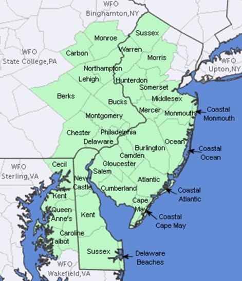
2 Main Points Hazard Impacts Location Timing Snow Snow will create hazardous travel conditions. Roadways will be snow covered. Travel conditions for most of the day Wednesday will be impacted, and there is particular concern regarding the evening commute. NJ, east-central and southeast PA, DE, northeast MD. Snow will gradually overspread these areas from southwest to northeast tomorrow morning, from around 6AM to 12PM, with the most intense snow in the late morning and early afternoon. Sleet and Freezing Rain A period of sleet and freezing rain following the initial period of snow will exacerbate already hazardous travel conditions, with up to a tenth of an inch of ice accumulation. Eastern and southeastern PA, northern and western NJ, far northeast MD, far northern DE. Snow will transition to an extended period of sleet and freezing rain from mid-afternoon through the evening. Elsewhere, snow should transition to rain with only a brief mix expected.

3 Summary of Greatest Impacts Snow: NJ, E PA, DE, NE MD None Limited Elevated Significant Extreme Wintry Mix: E PA, N and W NJ, N DE, NE MD None Limited Elevated Significant Extreme

4 Expected Snowfall Accumulations Uncertainty in Snowfall Forecast: As with other storms this season, considerable uncertainty exists in the snowfall forecast owing to critical timings of transitions between snow, ice, and rain. While confidence in exact snowfall totals is medium at best, confidence is higher on a period of significant and widespread travel impacts, especially from mid-morning through the evening.
 Chance of Higher Snowfall Than Depicted")
5 Probabilistic Snowfall Forecast Low End Potential 9 in 10 (90%) Chance of Higher Snowfall Than Depicted Below High End Potential 1 in 10 (10%) Chance of Higher Snowfall Than Depicted Below
6 Expected Ice Accumulations Ice accumulation notes: Icing of a few hundredths to a tenth of an inch is generally insufficient to produce tree damage or power outages, but any amount of ice is capable of creating very hazardous road conditions.
7 Precipitation Onset Time Onset Time Notes: This map represents our best estimate for when snow will begin tomorrow. Owing to cold temperatures tonight, snow should begin accumulating on all untreated surfaces soon after it begins falling.


8 Event Summary A winter storm will impact the area from early tomorrow morning through tomorrow night. A variety of precipitation types are expected. Travel impacts are likely for most of the day Wednesday, except in central and northern NJ and east-central PA where most of the morning should remain dry before snow begins. For all areas, the evening commute is the period of greatest concern, but morning commute impacts are possible in northeast MD, DE, southern NJ, and far southeast PA All areas will likely see precipitation begin as snow. A gradual transition from snow to a mix of sleet and freezing rain, then rain, will occur tomorrow afternoon and evening. Rain will continue for most of the night, potentially ending near daybreak Thursday. Over far northern NJ and the Poconos, precipitation may never transition to plain rain, instead staying as a mix of sleet and freezing rain after the initial period of snow. Considerable uncertainty exists in how much snow will fall. However, confidence is higher in an extended period of poor travel conditions during most of the daytime hours tomorrow, with particular concern for the afternoon and evening. Up to a tenth of an inch of ice is expected in eastern PA and northern NJ, which will lead to hazardous travel conditions into Wednesday night. Over southern NJ and Delmarva, only a brief period of icing is expected before a transition to rain. Localized minor coastal flooding is possible during the Wednesday morning high tide cycle, but this is not expected to be a widespread or significant concern. Strong winds are also not expected to be a concern.


9 Contact and Next Briefing Information Next Briefing By 6:00 AM Wednesday, February 20, 2019 Briefing Webpage: Web: Facebook: Phone (public): (609) Twitter: Disclaimer: The information contained in this briefing is timesensitive; do not use after the next briefing package is issued.
Winter Storm Today into Tonight
 Winter Storm Today into Tonight Decision Support Briefing #2 As of 6 AM Wednesday, February 20, 2019 What Has Changed? Minor adjustments to forecast snow and ice amounts. Main Points Hazard Impacts Location
Snow Tonight and Sunday
 Snow Tonight and Sunday Decision Support Briefing #4 As of 4:00 PM Saturday, Jan. 12, 2019 What Has Changed? Winter Storm Warning has been issued for portions of Delmarva and the Winter Weather Advisory
Winter Weather Threat Friday night and Saturday January 7, 2017
 Winter Weather Threat Friday night and Saturday January 7, 2017 National Weather Service Newport/Morehead City, NC Date/Time Created: 1/6/2017, 6 AM EST Winter Weather Threat Summary Tonight and Saturday
NOAA s National Weather Service Philadelphia/Mt. Holly NJ
 Early Week Coastal Flooding and snow Hazards and Impacts: Coastal Flooding: With the persistent onshore flow, and a new moon today, coastal flooding is expected at high tide through Tuesday morning. Moderate
Weather Briefing. Coastal Storm Monday-Wednesday Dec 8-10, National Weather Service. Prepared 12/8/14 6:30 AM
 Weather Briefing Coastal Storm Monday-Wednesday Dec 8-10, 2014 National Weather Service http://www.weather.gov/nyc Prepared 12/8/14 6:30 AM Overview of Potential Hazards A strong low pressure system will
Nor easter Monday Night Wednesday December 8 10, 2014
 Nor easter Monday Night Wednesday December 8 10, 2014 Prepared 400 PM EST Monday, December 8, 2014 Mitchell Gaines NOAA s Philadelphia/Mount Holly NJ Forecast Office www.weather.gov/phi/ Purpose of Briefing
A Prepared Marylander Creates a Resilient Maryland
 Maryland Emergency Management Agency Operations Directorate Hazardous Winter Weather Outlook Briefing March 5, 2013 0800 A Prepared Marylander Creates a Resilient Maryland A strong low pressure will track
IWT Scenario 2 Integrated Warning Team Workshop National Weather Service Albany, NY October 31, 2014
 IWT Scenario 2 Integrated Warning Team Workshop National Weather Service Albany, NY October 31, 2014 09 10 11 12 13 Scenario 2 Timeline December 9-13 Tue Wed Thu Fri Sat Tue, Dec. 9 @ 5 am 2014 2014 2014
Weather Briefing Mixed Winter Storm Event February 26-27, 2013
 Weather Briefing Mixed Winter Storm Event February 26-27, 2013 Prepared 1200 PM EST Tuesday, February 26th, 2013 Joe Miketta NOAA s NJ Forecast Office http://www.erh.noaa.gov/phi/ Purpose of Briefing Briefing
Jan 7, 2017 Winter Weather Event
 Jan 7, 2017 Winter Weather Event Decision Support Briefing # 5 Assessment for northeast South Carolina & southeast North Carolina National Weather Service Wilmington NC 4 PM EST Friday January 6, 2017
Winter Storm Update. Through Late Afternoon: Jacksonville, FL Weather Forecast Office. Northeast Florida and Southeast Georgia
 Winter Storm Update Through Late Afternoon: Winter Storm Warning for all of Southeast GA and portions of Suwannee Valley and I-10 Corridor west of Jacksonville. Dangerous ice storm expected from Live Oak
Winter Storm Saturday into Sunday December 14-15, 2013
 Winter Storm Saturday into Sunday December 14-15, 2013 Prepared 900 AM EST Friday December 13, 2013 Al Cope NOAA s NJ Forecast office http://www.erh.noaa.gov/phi/ Purpose of Briefing Briefing #3 for event.
Active Winter Weather Pattern February 4th-9th
 Active Winter Weather Pattern February 4th-9th Prepared 1230 PM EST Tuesday, February 4, 2014 Gary Szatkowski NOAA s NJ Forecast office http://www.erh.noaa.gov/phi/ Purpose of Briefing Briefing #6 Promote
A Complex Weather System: Tuesday Afternoon into Thursday March 3 5, 2015
 A Complex Weather System: Tuesday Afternoon into Thursday March 3 5, 2015 Briefing #1, prepared 900 AM EST Tuesday, March 3, 2015 by Meteorologists at NWS - WFO Mount Holly, NJ To promote situational awareness
Jan 7, 2017 Winter Weather Event
 Jan 7, 2017 Winter Weather Event Decision Support Briefing # 4 Assessment for northeast South Carolina & southeast North Carolina National Weather Service Wilmington NC 8 AM EST Friday January 6, 2017
NOAA s National Weather Service Philadelphia/Mt. Holly NJ. Summary. Changes
 Summary A crippling and potentially historic east coast snow storm will lead to blizzard conditions and major coastal flooding for portions of the area this weekend. Changes Blizzard Warning has been expanded
IWT Scenario 1 Integrated Warning Team Workshop National Weather Service Albany, NY October 31, 2014
 Integrated Warning Team Workshop National Weather Service Albany, NY October 31, 2014 23 24 25 26 27 Scenario 1 Timeline November 23-27 Sun Mon Tue Wed Thu Thanksgiving Day Sunday, Nov. 23 @ 430 pm NWS
Significant Coastal Storm Today through Thursday, 11/7-8. Weather Briefing
 Significant Coastal Storm Today through Thursday, 11/7-8 Weather Briefing Prepared 10:00 am EST Wednesday, November 7, 2012 Presented by Gary Conte, Warning Coordination Meteorologist NOAA s National Weather
Weather Briefing for Pennsylvania Feb Outlook Prepared 02/11/14 2 pm EST
 Weather Briefing for Pennsylvania Feb. 12-13 Outlook Prepared 02/11/14 2 pm EST Prepared by: National Weather Service State College, PA (Peter.Jung@noaa.gov) Pennsylvania Weather Overview A significant
Tuesday, January 16, AM
 Tuesday, January 16, 2018 10 AM Weather Forecast Office Peachtree City, GA Disclaimer: The Information Contained within this Briefing is Time Sensitive, and Could Affect its Validity as the Date/Time Moves
Winter Storm Briefing #3 Monday Evening Wednesday Evening
 Winter Storm Briefing #3 Monday Evening Wednesday Evening Tuesday March 14, 2017 Disclaimer: The information contained within this briefing is time-sensitive. Do not use after 4AM Wednesday. Applies to
Coastal Storm. Wednesday through Friday, 3/6-8/2013 Weather Briefing
 Coastal Storm Wednesday through Friday, 3/6-8/2013 Weather Briefing Prepared 2:00 PM EST Wednesday, March 6, 2013 National Weather Service New York, NY Purpose of Briefing Promote Situational Awareness
Significant Flooding Expected
 Significant Flooding Expected Decision Support Briefing #5 As of: 9:00 AM September 14, 2018 What Has Changed? Flash Flood Watch now in effect for part of area, will be expanded later today 9/14/2018 9:23
California OES Weather Threat Briefing
 California OES Weather Threat Briefing Wednesday, January 16, 2019 9:00 AM PST Day 1: Strong winds, heavy mountain snow and heavy rain with isolated thunderstorms across much of the state through Thursday
****Approaching Winter Storm ****
 ****Approaching Winter Storm **** 02/12/2013 The Flemington Borough Office of Emergency Management is currently monitoring the incoming winter storm expected to impact our area starting Thursday morning
Weather briefing Strong Coastal Nor easter November 7 th -8 th, 2012
 Weather briefing Strong Coastal Nor easter November 7 th -8 th, 2012 Prepared 1215 PM EDT Wednesday November 7, 2012 Gary Szatkowski NOAA s NJ Forecast Office http://www.erh.noaa.gov/phi/ Purpose of Briefing
WEATHER NOTIFICATION STATEMENT
 WEATHER NOTIFICATION STATEMENT NEW DATA SHOWS SNOWSTORM THREAT FOR JAN 13-14 LOOKS MUCH HEAVIER BIGGER COVERAGE northwest NC (ice) ALL OF VA (Except Hampton Roads) all of MD/ DEL eastern southern PA southern
Coastal Storm this Weekend
 Weather Briefing Prepared 9 AM EST Feb 5, 2010 Joe Miketta Warning Coordination Meteorologist NOAA s National Weather Service Philadelphia/Mt. Holly NJ Forecast Office 609-261 261-6602 6602 x223 Joseph.Miketta@noaa.gov
Major Winter Storm to impact Western Washington. 17 January 2012 National Weather Service Seattle/Tacoma
 Major Winter Storm to impact Western Washington 17 January 2012 National Weather Service Seattle/Tacoma Current Warnings Winter Storm Warning for all of Western Washington, except: Northwest interior Extreme
Winter Storm of 15 December 2005 By Richard H. Grumm National Weather Service Office State College, PA 16803
 Winter Storm of 15 December 2005 By Richard H. Grumm National Weather Service Office State College, PA 16803 1. INTRODUCTION A complex winter storm brought snow, sleet, and freezing rain to central Pennsylvania.
January 2006 Climate Summary
 Ashley Brooks (765) 494-6574 Feb 9, 2006 http://www.iclimate.org January 1-3 January 2006 Climate Summary Unseasonably warm conditions welcomed in the New Year with highs in the 40s across the northern
W I N T E R STORM HAZARD DESCRIPTION
 W I N T E R STORM HAZARD DESCRIPTION... 1 LOCATION... 2 EXTENT... 2 HISTORICAL OCCURRENCES... 4 SIGNIFICANT PAST EVENTS... 4 PROBABILITY OF FUTURE EVENTS... 5 VULNERABILITY AND IMPACT... 5 HAZARD DESCRIPTION
NOAA s National Weather Service Philadelphia/Mt. Holly NJ
 Snow and Coastal Flooding through this evening Hazards and Impacts: Coastal Flooding: With the persistent onshore flow, and a new moon yesterday, coastal flooding is expected at high tide today. Moderate
National Situation Report As of 5:00 a.m. EDT Tuesday, April 4, 2017
 Overview National Situation Report As of 5:00 a.m. EDT Tuesday, April 4, 2017 Table Of Contents Current Operations Monitoring Recovery National Response Coordination Center: Not Activated National Watch
Weather briefing Strong Coastal Nor easter November 7 th -8 th, 2012
 Weather briefing Strong Coastal Nor easter November 7 th -8 th, 2012 Prepared 1245 PM EDT Tuesday November 6, 2012 Gary Szatkowski NOAA s NJ Forecast Office Weather.gov/phi Purpose of Briefing Briefing
Safety Matters C ENTENNIAL SCHOOL DISTRICT
 C ENTENNIAL SCHOOL DISTRICT Volume 3, Number 7 Safety Matters Safety Matters is the monthly awareness letter of the Centennial School District certified Joint Labor/ Management Workplace Safety Committee.
Weather Report 05 January 2018
 Weather Report 05 January 2018 South Africa - Weather Crop conditions will remain generally favorable across eastern South Africa during the next two weeks. Net drying will gradually reduce soil moisture,
HURRICANE IRENE. CONFERENCE CALL BRIEFING SLIDES Saturday August 27, :30 AM
 HURRICANE IRENE CONFERENCE CALL BRIEFING SLIDES Saturday August 27, 2011 8:30 AM NHC TRACK AND CONE HURRICANE IRENE WATCHES/WARNINGS Hurricane Warning along south coast including all of Cape Cod and Islands
Severe Weather Watches, Advisories & Warnings
 Severe Weather Watches, Advisories & Warnings Tornado Watch Issued by the Storm Prediction Center when conditions are favorable for the development of severe thunderstorms and tornadoes over a larger-scale
HAZARD DESCRIPTION... 1 LOCATION... 1 EXTENT... 1 HISTORICAL OCCURRENCES...
 WINTER STORM HAZARD DESCRIPTION... 1 LOCATION... 1 EXTENT... 1 HISTORICAL OCCURRENCES... 3 SIGNIFICANT PAST EVENTS... 4 PROBABILITY OF FUTURE EVENTS... 5 VULNERABILITY AND IMPACT... 5 Hazard Description
Severe Weather Potential for Southeast Texas
 Severe Weather Potential for Southeast Texas Dan Reilly, Kent Prochazka, Scott Overpeck National Weather Service Houston/Galveston 10 am Synopsis Storm to likely bring severe weather to Southeast Texas
TROPICAL STORM HARVEY BRIEFING
 TROPICAL STORM HARVEY BRIEFING 2:00 PM CDT Tuesday, August 29, 2017 Prepared by: NWS LIX NWSNewOrleans www.weather.gov/neworleans Situation Overview New Information Moving NNE Max sustained wind 45 mph
Weather Briefing for Pennsylvania January 5-8, 2014 Prepared 01/05/14 (1:30 PM EST)
") Weather Briefing for Pennsylvania January 5-8, 2014 Prepared 01/05/14 (1:30 PM EST) Prepared by: National Weather Service State College, PA (john.lacorte@noaa.gov) Latest Radar Latest Surface Weather Plots
Weather Briefing for Pennsylvania January 5-8, 2014 Prepared 01/05/14 (1:30 PM EST) Prepared by: National Weather Service State College, PA (john.lacorte@noaa.gov) Latest Radar Latest Surface Weather Plots
Daily Operations Briefing Monday, January 26, :30 a.m. EST
 Daily Operations Briefing Monday, January 26, 2015 8:30 a.m. EST Significant Activity: Jan 25-26 Significant Events: Severe Winter Weather Mid-Atlantic to Northeast Significant Weather: Heavy Snow Mid-Atlantic
Daily Operations Briefing Tuesday, April 4, :30 a.m. EDT
 Daily Operations Briefing Tuesday, April 4, 2017 8:30 a.m. EDT Significant Activity Apr 3-4 Significant Events: Severe Weather Southern Plains to Southeast Significant Weather: Severe Thunderstorms and
TFS WEATHER BRIEF. Monday, March 25
 TFS WEATHER BRIEF Monday, March 25 Review: The leading edge of cooler and drier air was pushing through Central and East TX this morning. A few lingering thunderstorms were in progress south of I-20 in
CropCast Corn and Soybean Report Kenny Miller Friday, March 17, 2017
 Accumulated Rainfall (inches) Accumulated GDDs Temperature ( F)/Wind Speed (mph) Precipitation (inches) CropCast Corn and Soybean Report Kenny Miller Friday, March 17, 2017 Peoria, IL Regional Forecast
Major Hurricane Matthew Briefing Situation Overview
 Major Hurricane Matthew Briefing Situation Overview At 5 p.m. Tuesday, Category 4 Hurricane Matthew was about 860 miles South-Southeast of Mayport, Florida, moving north around 10 mph. Maximum sustained
Daily Operations Briefing. Sunday, March 4, :30 a.m. EST
 Daily Operations Briefing Sunday, March 4, 2018 8:30 a.m. EST Significant Activity Mar 3-4 Significant Events: Northeast coastal storm Tropical Activity: Western Pacific No activity affecting U.S. interests
California OES Atmospheric River Events Weather Threat Briefing
 California OES Atmospheric River Events Weather Threat Briefing 23 February 2017 10:00 AM PST Day 1: Flooding continues along small streams and creeks and some main stem rivers. National Weather Service
Snow Measurement Guidelines for National Weather Service Snow Spotters
 Snow Measurement Guidelines for National Weather Service Snow Spotters National Weather Service Forecast Office Northern Indiana October 2004 Table of Contents Introduction 3 Definitions.. 3 Relaying Real
Daily Operations Briefing Thursday, April 6, :30 a.m. EDT
 Daily Operations Briefing Thursday, April 6, 2017 8:30 a.m. EDT Significant Activity Apr 5-6 Significant Events: Severe Weather Southeast and Mid-Atlantic Significant Weather: Severe thunderstorms possible
Daily Operations Briefing Sunday, January 15, :30 a.m. EST
 Daily Operations Briefing Sunday, January 15, 2017 8:30 a.m. EST Significant Activity Jan 14-15 Significant Events: Winter Storm central U.S. Significant Weather: Severe Thunderstorms TX Flash Flooding
Daily Operations Briefing Sunday, January 8, :30 a.m. EST
 Daily Operations Briefing Sunday, January 8, 2017 8:30 a.m. EST Significant Activity Jan 6-8 Significant Events: Heavy Precipitation forecast to impact CA and NV Significant Weather: Freezing rain Pacific
The Pennsylvania Observer
 The Pennsylvania Observer April 2, 2009 March 2009 Pennsylvania Weather Recap Prepared by Curt Harpster For the month of March the saying, In like a lion and out like a lamb really fit the pattern quite
Weekly Weather Briefing. NWS Albuquerque. Tuesday Soaker. NWS Albuquerque August 25, Weekly Weather Briefing
 Weekly Weather Briefing Weekly Weather Briefing Tuesday Soaker August 25, 2014 August 2014 vs. 2013 Precipitation Percent of Average August 1-24, 2014 August 2013 Weekly Weather Briefing ABQ **Preliminary**
NOAA s National Weather Service Philadelphia/Mt. Holly NJ
 Next Briefing Package: Friday, October 2, 2015 no later than 300 PM Hazards and Impacts: Overview: A dangerous weather pattern still threatens our region. Threats include very heavy rainfall, inland river
Daily Operations Briefing Wednesday, February 8, :30 a.m. EST
 Daily Operations Briefing Wednesday, February 8, 2017 8:30 a.m. EST Significant Activity Feb 7-8 Significant Events: Severe weather/tornadoes - Louisiana Significant Weather: Freezing rain possible Pacific
School for Highway Superintendents Real-Time Local Weather Information
 School for Highway Superintendents Real-Time Local Weather Information Mark W. Wysocki Senior Lecturer in Meteorology Cornell University New York State Climatologist Keith Eggleston and Kathy Veerland
TROPICAL STORM HARVEY BRIEFING
 TROPICAL STORM HARVEY BRIEFING 10:00 AM CDT Sunday, August 27, 2017 Prepared by: NWS LIX NWSNewOrleans www.weather.gov/neworleans Situation Overview New Information Tropical Storm Winds 40mph Immediate
Weekly Weather Briefing. NWS Albuquerque. Severe Threat Central & East through Tonight, then Drying. NWS Albuquerque September 29, 2014
 Severe Threat Central & East through Tonight, then Drying September 29, 2014 Today s Max Temp Departure from Normal Notable Severe Weather Events in September* September 30, 1998 Los Lunas: 4.5 Hail*
Wind Events. Flooding Events. T-Storm Events. Awareness Alerts / Potential Alerts / Action Alerts / Immediate Action Alerts / Emergency Alerts.
 Information Updated: February of 2016 Our Alert Terms Definitions * Use exactly as seen below * Wind Events Awareness Alert - Strong Winds Potential Alert - Damaging Winds ACTION Alert - Damaging Winds
photo courtesy of
 BRITISH VIRGIN ISLANDS REPORT TROPICAL STORM JEANNE photo courtesy of www.bviplatinum.com PREPARED BY THE DEPARTMENT OF DISASTER MANAGEMENT 1 EVENT 13 th -16 th September, 2004 TROPICAL STORM JEANNE Sequence
Rooster Comb Ridge Cornice Incident
 Rooster Comb Ridge Cornice Incident April 3, 2011 Date/time: Sunday, April 3, 2011 / ~12:45pm PDT Submitted by: Patty Morrison Stevens Pass Winter Resort Snow Safety; Mark Moore NWAC Place: High point
Daily Operations Briefing Friday, January 13, :30 a.m. EST
 Daily Operations Briefing Friday, January 13, 2017 8:30 a.m. EST Significant Activity Jan 12-13 Significant Events: Heavy precipitation - western U.S. FINAL Winter storm central U.S. Significant Weather:
Hurricane Harvey: SE Texas Impacts. 10 PM CDT UPDATE Friday, August 25, 2017 Prepared by: Lance Wood
 Hurricane Harvey: SE Texas Impacts 10 PM CDT UPDATE Friday, August 25, 2017 Prepared by: Lance Wood Latest Observations Hurricane Harvey making landfall this evening near Rockport as a category 4 hurricane.
but 2012 was dry Most farmers pulled in a crop
 After a winter that wasn t, conditions late in the year pointed to a return to normal snow and cold conditions Most farmers pulled in a crop but 2012 was dry b y M i k e Wr o b l e w s k i, w e a t h e
DISCUSSION --1/ 4 /19
 ISSUED: 4 JNURY 1715 EST WXRISK VIDEO WINTER FORECST short version WXRISK VIDEO WINTER FORECST Long version DISCUSSION --1/ 4 /19 *** STRONG SIGNS OF RETURN TYPICL JNURY TEMPS... DEVELOPING FTER JN 9 ***
The hydrologic service area (HSA) for this office covers Central Kentucky and South Central Indiana.
 for this office covers Central Kentucky and South Central Indiana.") January 2012 February 13, 2012 An X inside this box indicates that no flooding occurred within this hydrologic service area. January 2012 continued the string of wet months this winter. Rainfall was generally
January 2012 February 13, 2012 An X inside this box indicates that no flooding occurred within this hydrologic service area. January 2012 continued the string of wet months this winter. Rainfall was generally
Hydrologic Briefing Tropical Storm Harvey
 Hydrologic Briefing Tropical Storm Harvey 5:00 PM CDT Sunday, August 27, 2017 Prepared by: Jennifer Dunn/Christina Barron NWSCorpus www.weather.gov/corpuschristi Situation Overview Tropical Storm Harvey
Tropical Update. 11 AM EDT Tuesday, October 9, 2018 Hurricane Michael, Tropical Storm Leslie, Tropical Storm Nadine
 Tropical Update 11 AM EDT Tuesday, October 9, 2018 Hurricane Michael, Tropical Storm Leslie, Tropical Storm Nadine This update is intended for government and emergency response officials, and is provided
Summary of November Central U.S. Winter Storm By Christopher Hedge
 Summary of November 12-13 2010 Central U.S. Winter Storm By Christopher Hedge Event Overview The first significant snowfall of the 2010-2011 season affected portions of the plains and upper Mississippi
INVISIBLE WATER COSTS
 Every Drop Every Counts... Drop Counts... INVISIBLE WATER COSTS Corn - 108.1 gallons per pound How much water it takes to produce... Apple - 18.5 gallons to grow Beef - 1,581 gallons per pound Oats - 122.7
Daily Operations Briefing Friday, January 29, :30 a.m. EST
 Daily Operations Briefing Friday, January 29, 2016 8:30 a.m. EST Significant Activity: Jan 28-29 Significant Events: None Significant Weather: Rain/thunderstorms (flash flooding possible) California and
2011 Year in Review TORNADOES
 2011 Year in Review The year 2011 had weather events that will be remembered for a long time. Two significant tornado outbreaks in April, widespread damage and power outages from Hurricane Irene in August
Heavy Rain and Potential for Dangerous Flooding for northeast SC and southeast NC
 US National Weather Service Wilmington NC @NWSWilmingtonNC http://weather.gov/ilm ***Life Threatening Flooding Possible*** Heavy Rain and Potential for Dangerous Flooding for northeast SC and southeast
TROPICAL STORM NATE BRIEFING
 TROPICAL STORM NATE BRIEFING 5:00 AM CDT Friday, October 6, 2017 Prepared by: NWS NWSNewOrleans www.weather.gov/neworleans Situation Overview No significant changes to the track forecast this morning.
CropCast Corn and Soybean Report Kenny Miller Monday, March 13, 2017
 Accumulated Rainfall (inches) Accumulated GDDs Temperature ( F)/Wind Speed (mph) Precipitation (inches) CropCast Corn and Soybean Report Kenny Miller Monday, March 13, 2017 Peoria, IL Regional Forecast
TROPICAL STORM HARVEY COE Navigation Call - Update
 TROPICAL STORM HARVEY COE Navigation Call - Update 10:00 AM CDT Tuesday, August 29, 2017 Prepared by: NWS LIX NWSNewOrleans www.weather.gov/neworleans Situation Overview New Information Drifting ENE at
Daily Operations Briefing Wednesday, February 5, :30 a.m. EST
 Daily Operations Briefing Wednesday, February 5, 2014 8:30 a.m. EST Significant Activity: February 4 5 Significant Events: Winter Weather Plains to Northeast Propane Gas Shortage Midwest Significant Weather:
Hurricane Matthew Life Threatening Flash Flooding Likely
 Hurricane Matthew Life Threatening Flash Flooding Likely Threat Assessment for northeast South Carolina & southeast North Carolina National Weather Service Wilmington NC 12 AM EDT Saturday October 8, 2016
CropCast Corn and Soybean Report Kenny Miller Tuesday, March 14, 2017
 Accumulated Rainfall (inches) Accumulated GDDs Temperature ( F)/Wind Speed (mph) Precipitation (inches) CropCast Corn and Soybean Report Kenny Miller Tuesday, March 14, 2017 Peoria, IL Regional Forecast
The Pennsylvania Observer
 The Pennsylvania Observer October 1, 2015 September 2015 - Pennsylvania Weather Recap By: Quinn Lease The month of September will be remembered for its above normal temperatures and dry conditions that
Potentially Wet Wed-Fri
 Potentially Wet Wed-Fri August 18, 2014 Last Week s Lightning Trends TUE 8/12 WED 8/13 THU 8/14 FRI 8/15 t SAT 8/16 SUN 8/17 August 1-16 Precipitation Anomaly: 2013 VS. 2014 AUG 1-16, 2013 AUG 1-16, 2014
Fronts. Direction of Front
 Fronts Direction of Front Direction of Front Warm Front A cold air mass meets and displaces a warm air mass. Because the moving cold air is more dense, it moves under the less-dense warm air, pushing it
Page 1. Name:
 Name: 1) As the difference between the dewpoint temperature and the air temperature decreases, the probability of precipitation increases remains the same decreases 2) Which statement best explains why
Daily Operations Briefing Friday, March 17, :30 a.m. EDT
 Daily Operations Briefing Friday, March 17, 2017 8:30 a.m. EDT Significant Activity Mar 16-17 Significant Events: None Significant Weather: Heavy snow Cascades Snow and freezing rain Upper Mississippi
Champaign-Urbana 1998 Annual Weather Summary
 Champaign-Urbana 1998 Annual Weather Summary ILLINOIS STATE WATER SURVEY Audrey Bryan, Weather Observer 2204 Griffith Dr. Champaign, IL 61820 wxobsrvr@sparc.sws.uiuc.edu The development of the El Nìno
Monday, May 28, :30 a.m. EDT
 Monday, May 28, 2018 8:30 a.m. EDT Significant Activity May 27-28 Significant Events: Subtropical Storm Alberto; Ellicott City, MD flooding Tropical Activity: Atlantic Subtropical Storm Alberto Significant
NOAA s National Weather Service Philadelphia/Mt. Holly NJ
 Next Briefing Package: Thursday, October 1, 2015 no later than 300 PM Hazards and Impacts: Overview: A dangerous weather pattern is developing for our region. Threats include very heavy rainfall, inland
Integrated Warning Team Workshop National Weather Service - Albany, NY October 31, 2014
 Integrated Warning Team Workshop National Weather Service - Albany, NY October 31, 2014 Scenario #1 = November 23 27 (Note: November 27 = Thanksgiving) Initial Overview: A storm system will track from
Hurricane Matthew. Life Threatening Flash Flooding Likely. National Weather Service Wilmington NC. Josh Weiss, Meteorologist
 Hurricane Matthew Life Threatening Flash Flooding Likely Threat Assessment for northeast South Carolina & southeast North Carolina National Weather Service Wilmington NC 630 PM EDT Friday October 7, 2016
What we are trying to accomplish during the winter season
 What we are trying to accomplish during the winter season Safety first None of this is worth getting hurt over. Change your observation time if you delay your normal observation for safety reasons. Accuracy
Tropical Storm Harvey: SE Texas Impacts. 10 AM CDT UPDATE Sunday August 27, 2017 Prepared by: Lance Wood
 Tropical Storm Harvey: SE Texas Impacts 10 AM CDT UPDATE Sunday August 27, 2017 Prepared by: Lance Wood Situation Overview Catastrophic flooding is ongoing with flash flood emergencies remaining in effect.
TROPICAL DEPRESSION HARVEY BRIEFING
 TROPICAL DEPRESSION HARVEY BRIEFING 10:15 PM CDT Wednesday, August 23, 2017 Prepared by: Lara Beal NWSCorpus www.weather.gov/corpuschristi Situation Overview No changes to Watches. Hurricane Watch remains
The Pennsylvania Observer
 The Pennsylvania Observer January 5, 2009 December 2008 Pennsylvania Weather Recap The final month of 2008 was much wetter than average and a bit colder than normal. In spite of this combination, most
FLOOD REPORT FOR MANITOBA. June 28, A Gale wind warning is in effect for Lake Manitoba and Lake Winnipeg
 FLOOD REPORT FOR MANITOBA June 28, 2014 A Gale wind warning is in effect for Lake Manitoba and Lake Winnipeg Flood Warning*: Flood Watch*: High Water Advisory*: - Assiniboine River, from Shellmouth Dam
2015: A YEAR IN REVIEW F.S. ANSLOW
 2015: A YEAR IN REVIEW F.S. ANSLOW 1 INTRODUCTION Recently, three of the major centres for global climate monitoring determined with high confidence that 2015 was the warmest year on record, globally.
Daily Operations Briefing Saturday, October 1, :30 a.m. EDT
 Daily Operations Briefing Saturday, October 1, 2016 8:30 a.m. EDT Significant Activity Sept 30-Oct 1 Significant Events: None Tropical Activity: Atlantic Hurricane Matthew (CAT4); Disturbance 1 Low (10%)
Daily Operations Briefing. Thursday, February 13, :30 a.m. EST
 Daily Operations Briefing Thursday, February 13, 2014 8:30 a.m. EST Significant Activity: February 12 13 Significant Events: Winter Storm Southern Plains to Mid-Atlantic Significant Weather: Freezing rain