Tornado Dynamics. Readings:
|
|
|
- Judith Matthews
- 5 years ago
- Views:
Transcription
1 Tornado Dynamics Readings: Klemp (1987) Dynamics of Tornadic Thunderstorms (handout) Bluestein Vol II. Section Rotunno, R., 1986: Tornadoes and tornadogenesis. In: P. Ray (Editor), Mesoscale Meteorology and Forecasting. AMS, Boston, Houze Sections Definition: tornado, n. A rotating column of air usually accompanied by a funnel-shaped downward extension of a cumulonimbus cloud and having,..[winds] whirling destructively at speeds of up to 300 miles per hour. (American Heritage Dictionary of the English Language) This definition reflects a fundamental property of the tornado: it occurs in association with a thunderstorm. 1
2 Tornado Climatology in the US Tornadoes in the United States are reported most frequently in a band stretching from West and North Texas through Oklahoma, central and eastern Kansas, and into eastern Nebraska. This region is referred to as tornado alley. 2
3 Tornado Climatology based on updated data Mean number of days per century with at least one F2 or greater tornado touching down in grid box. Based on data from Contour interval 5 days with lowest contour 5. From Concannon, Brooks and Doswell (2002), Second Conference on Environmental Applications. 3
4 The elevated terrain to the west and southwest of the Great Plains and the Gulf of Mexico play important roles in producing soundings having high amounts of CAPE. The sloping terrain is partially responsible for the lee trough and low-level jet, the latter which advects the Gulf marine layer northward, while warm dry air caps the moist layer. The ubiquitous dryline and fronts approaching from the north and northwest are frequent locations of storm formation. Most tornadoes occur during the late afternoon and evening hours in the late spring. This suggests that solar heating plays an important role in producing a potentially unstable environment for tornadic storm formation during the afternoon. Major outbreaks occur primarily during the spring, when strong disturbances in the middle and upper troposphere promote regions of strong lifting and an environment of strong vertical shear and high values of CAPE. Tornadic activity begins along the Gulf States in late winter, and migrates northward, so that summer activity is highest in the Northern Plains. Environments for tornado outbreaks in the United States have been produced as far east as the East Coast. Tornado outbreaks in late spring and early summer are often associated with short waves moving through northwesterly flow aloft, as a ridge is built up to the west and a trough is ensconced to the east. In spring, outbreaks usually occur in southwesterly flow aloft, downstream from major troughs. 4
5 Relation of tornadoes to supercell storms Although not all supercell storms produce tornadoes, most of the intense tornadoes are generated by them. In a radar study of Oklahoma storms during , for example, Burgess (1976) found that 62% of the 37 storms that exhibited strong storm-scale rotation developed tornadoes while none occurred in storms which did not rotate. 5
6 Transition of storms into their tornado phase When a storm does move into its tornadic phase, significant alteration of the storm-scale structure occurs that disrupts the nearly steady configuration. These changes include a rapid increase in low-level rotation, a decrease in updraft intensity, a small-scale downdraft forming behind the updraft, and a flow at low levels in which cold-outflow and warm-inflow air spiral around the center of circulation. As the downdraft (labeled RFD) adjacent to the updraft intensifies, downdraft outflow progresses cyclonically around the center of rotation (marked by the northern encircled T), which is the likely location for tornado formation. As this outflow pushes into the path of the oncoming moist inflow, a new updraft and center of rotation may also develop tornadic intensity (denoted by the southern encircled T in Figure 11). At the same time, the spreading downdraft outflow cuts off the supply of warm moist air to the original circulation center (called occlusion), causing the original updraft to weaken. Although a supercell storm may persist in a nearly steady configuration for up to several hours, the transition to the tornadic phase illustrated in the figure may take place in less than about 10 min. 6

7 7
8 8
9 Figure 12 illustrates schematically the flow structure within a numerically simulated supercell evolving in a unidirectional wind shear at a time when the low-level rotation is intensifying rapidly, but prior to the formation of the occluded gust front shown in Figure 11. 9
10 Barnes (1978) and Lemon fe Doswell (1979) have suggested that this transition is initiated by the rear-flank downdraft (see Figure 11), which forms at midlevels, descends to the surface, and then intensifies the low-level rotation by producing strong shear (Barnes) or temperature gradients (Lemon & Doswell) between this downdraft and the updraft. The numerical storm simulations of Klemp & Rotunno (1983), Rotunno & Klemp (1985) and observational studies (Brandes 1984a,b) indicate a reverse sequence of events; the low-level rotation intensifies, followed by formation of the rear flank downdraft. Klemp & Rotunno (1983) proposed that the rear-flank downdraft that promotes this occlusion is, in fact, dynamically induced as strong low-level rotation lowers the pressure locally and draws down air from above. By decomposing the pressure field at a time when the simulated rear-flank downdraft was intensifying, they demonstrated that the fluid shear term was responsible for virtually the entire adverse vertical pressure gradient near the ground. Since the intensifying rotation is largest near the ground, a downward-directed pressure gradient results, which in turn promotes the downdraft. The retarding influence of rotation has been called the vortex valve effect; Lemon et al. (1975) suggested that as the rotation increases within the storm, this effect may be responsible for its collapse. 10
11 In the numerical simulation just described, the maximum low-level vertical vorticity remained less than one half the maximum at midlevels for over an hour, and then in less than 10 min it intensified to double the midlevel maximum. 11
12 Factors responsible for rapid amplification of the low-level rotation Analyses of the storm simulations demonstrate clearly that the intensification is stimulated by the baroclinic generation of strong horizontal vorticity along the low-level boundary of the cold air pool forming beneath the storm (Klemp and Rotunno 1983, Rotunno and Klemp 1985). Remember d η = B. dt x This horizontal vorticity is then tilted into the vertical and strongly stretched as the inflow enters the low-level updraft. To see how this situation arises, notice that in the evolving storm, precipitation is swept around to the northern side of the cyclonically rotating storm. As it falls to the north and northeast of the updraft, evaporation cools the lowlevel air. With time, this cold pool of air advances progressively into the path of the low-level inflow to the storm. A significant portion of the inflow can be approaching along the boundary of this cold air pool. The horizontal temperature gradients thus baroclinically generate horizontal vorticity that is nearly parallel to the inflowing streamlines. This process generates horizontal vorticity that is several times the magnitude of the mean shear vorticity and that is more favorably oriented to be tilted into vertical cyclonic vorticity. This same mechanism may also be responsible for tornadoes that form occasionally in non-supercellular storms. If a storm encounters a pre-existing cold front or an outflow boundary from another storm, strong horizontal vorticity (baroclinically generated along that boundary) may be swept into the storm and amplified. The low-level vortex lines depicted in Figures 12 and 13 further illustrate the baroclinic vorticity generation mechanism. 12
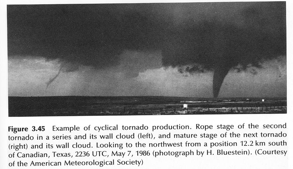
13 Since the environmental shear is westerly, the horizontal vortex lines embedded in the shear are oriented southnorth with the sense of rotation as indicated in the undisturbed region southeast of the storm in Figure 12. As these vortex lines penetrate the low-level pool of cold air, they turn rapidly toward the center of convergence and are swept into the updraft. At this stage, the low-level updraft is located along the boundary between the warm and cold air, and it intertwines the warm and cold flow in the rising air. As the rear-flank downdraft intensifies, this baroclinic generation supports the rapid intensification of rotation in the secondary updraft forming farther to the east along the gust front in Figure 13b. After the original updraft is cut off from the warm inflow, it begins to dissipate while the new updraft continues to strengthen. The strong rotation may then cause a new downdraft that spreads out at the surface, cuts off the inflow to this updraft, and promotes yet another convergence center farther east. (In Figure 13, visualize the eastern circulation center in 13b becoming the center shown in 13b, and then repeating the cycle.) Such cyclical redevelopments or tornadogenesis, accompanied by successive tornadoes, are not uncommon in tornadic storms (Burgess et al. 1982). See next example. 13
14 14
15 15
16 In summary, the typical sequence of events of tornado genesis (see good summary in Houze section 8.6): Storm-scale circulation and development creates the forward flank downdraft and gust front; The gust front creates intense horizontal vorticity that can be significant stronger the environmental horizontal vorticity; this vorticity gets advected into the center of storm and updraft, and is tilted into vertical and stretched to intensify the vertical rotation; This process is believed to be responsible for the intensification of rotation at the low levels, the lower end of the mesocyclone while the tilting of environmental vorticity is primarily responsible for the mid-level rotation/cyclone; The increased low-level rotation creates pressure minimum at the low levels and downward PGF, which promotes the RFD and weakens the original downdraft; The advection of cold air from RFD by the rotating circulation at the low levels cuts off warm air supply to the original updraft and causes occlusion of FF and RF gust fronts and the demise of tornado at the occlusion the tip of bust front wedge, and New tornadoes often form again at the occlusion point. 16
17 Typical Tornado Life Cycles from Observational Perspective Read Houze section 8.8. The tornado frequently first becomes visible as a dust whirl on the ground under the wall cloud. The condensation funnel soon appears aloft. Late in life, it may bend at the ground while it stretches in length and narrows in width. This final decaying stage in the tornado's life history is called the rope stage owing to the ropelike appearance of the condensation funnel. The gust front associated with the RFD may tilt the tornado so that it becomes nearly horizontal. The tornado life cycle of min is common, but not exclusive. For example, tornadoes sometimes occur in the absence of any condensation funnel, always look like a rope, or never go through a rope stage. Some long damage paths are associated with tornadoes that last much longer than 30 min. Most tornadoes in supercells are cyclonic. Anticyclonic tornadoes are rare. They have been documented, however, along the RFD gust front away from the mesocyclone. 17
18 Therefore the life cycle can be divided into: Organizing stage visible funnel touching ground intermittently mature stage - tornado reaches its full strength and damage most severe shrinking the funnel decreases to a thin column decay stage funnel becomes fragments, contorted and still destructive 18

19 19
20 Figure. Structure of a tornado observed at several stages of its life cycle. Sketches show funnel cloud and associated debris. 20
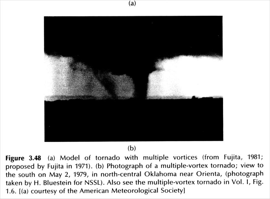
21 Multi-vortex tornadoes Although tornadoes frequently consist of a single vortex, they occasionally exist as two or more smaller "suction vortices" that rotate around the center of the wall cloud. Laboratory model and numerical model evidence suggests that multiple vortices are associated with high "swirl ratio," that is, relatively large azimuthal flow compared to radial flow. Suction vortices often have a lifetime of only one revolution around the wall cloud; new ones form and dissipate in the identical location relative to the mesocyclone. Sometimes multiple-vortex tornadoes evolve into single-vortex tornadoes, and vice versa. Some suction vortices extend all the way to cloud base; others are visible only near the ground underneath a broader rotating cloud base. The multiple-vortex phenomenon was first postulated by T. Fujita on the basis of cycloidal damage swaths. The "suction vortices" create greater maximum wind speed inside the tornadoes vortex because the effect due to the smaller and larger vortices are additive. They are observed to be particularly dangerous and damaging. 21
22 22
23 23
24 Nonsupercell tornadoes and Gustnadoes Read Houze section 8.7. Tornadoes don't occur exclusively in supercells. Non-supercell tornadoes can occur along a low-level convergence line underneath growing cumulus clouds. Preexisting vortices along the line get stretched in the vertical by updraft of the growing cumulus cloud and intensify to form usually relative weak tornadoes. 24
25 Low-level convergence helps concentrate the vertical vorticity. The vortex intensification can be further aided by rotation in the convective updraft. Gustnadoes are short lives vortices occurring along preexisting gust fronts, coming into existence mainly due to horizontal shear instability. Watersprouts: Vortices forming over water often along outflow boundaries of nearby shower. The processes involved are similar to the land-based non-supercell tornadoes forming along a gust front. Flow structure inside tornadoes The following schematic shows flow regions inside a tornado. 25
26 Region I is in cyclonstrophic balance Ia is called the outer flow region region of converging flow where angular momentum is conserved Ib is the core in a state of solid body rotation the angular velocity is constant and the core is stable against radial displacement The boundary between Ia and Ib is where max tangential velocity lies Flow along the core axis can be either up or down and there is little mixing with outside air II is region of turbulent boundary layer where cyclonstrophic is upset by friction Strong radial inflow exists in II towards III because of net inward force (centrifugal force is weaker due to frictional reduction in wind speed) III is called the corner region where inflow turns into core region Ib. Region IV is the region of buoyant updraft 26
27 Wind Speed inside tornadoes Horizontal wind speeds in tornadoes can be as high as m/s. There is some theoretical evidence that even stronger upward vertical velocities can occur near center of a tornado, near the ground. The maximum possible tornadic wind speed is a function not only of the hydrostatic-pressure deficit owing to latent-heat release in the updraft, which is a function of the CAPE, but also to the dynamic-pressure deficit, which is a function of the character of the wind field itself, especially in the surface boundary layer. 27
MET Lecture 26 Tornadoes I
 MET 4300 Lecture 26 Tornadoes I A Large Tornado approaches Lyndon, Kansas, on May 8, 2003 Outline Definition, life cycle Tornado formation within supercells Tornado formation within nonsupercell thunderstorms
Rotunno, R., 1986: Tornadoes and tornadogenesis. In: P. Ray (Editor), Mesoscale Meteorology and Forecasting. AMS, Boston,
, Mesoscale Meteorology and Forecasting. AMS, Boston,") Tornado and Tornado Dynamics Readings: Markowski and Richardson book section 10.1. Klemp (1987) Dynamics of Tornadic Thunderstorms (handout) Bluestein Vol II. Section 3.4.8. Rotunno, R., 1986: Tornadoes
Tornado and Tornado Dynamics Readings: Markowski and Richardson book section 10.1. Klemp (1987) Dynamics of Tornadic Thunderstorms (handout) Bluestein Vol II. Section 3.4.8. Rotunno, R., 1986: Tornadoes
Tornadogenesis in Supercells: The Three Main Ingredients. Ted Funk
 Tornadogenesis in Supercells: The Three Main Ingredients Ted Funk NWS Louisville, KY Spring 2002 Environmental Parameters Supercells occur within environments exhibiting several wellknown characteristics
The Earth System - Atmosphere III Convection
 The Earth System - Atmosphere III Convection Thunderstorms 1. A thunderstorm is a storm that produces lightning (and therefore thunder) 2. Thunderstorms frequently produce gusty winds, heavy rain, and
Chapter 3 Convective Dynamics 3.4. Bright Bands, Bow Echoes and Mesoscale Convective Complexes
 Chapter 3 Convective Dynamics 3.4. Bright Bands, Bow Echoes and Mesoscale Convective Complexes Photographs Todd Lindley Bright band associated with stratiform precipitation in a squall line system 1 Bright
Thunderstorms. Ordinary Cell Thunderstorms. Ordinary Cell Thunderstorms. Ordinary Cell Thunderstorms 5/2/11
 A storm containing lightning and thunder; convective storms Chapter 14 Severe thunderstorms: At least one: large hail wind gusts greater than or equal to 50 kt Tornado 1 2 Ordinary Cell Ordinary Cell AKA
Tornadoes forecasting, dynamics and genesis. Mteor 417 Iowa State University Week 12 Bill Gallus
 Tornadoes forecasting, dynamics and genesis Mteor 417 Iowa State University Week 12 Bill Gallus Tools to diagnose severe weather risks Definition of tornado: A vortex (rapidly rotating column of air) associated
Weather Systems III: Thunderstorms and Twisters
 Weather Systems III: Thunderstorms and Twisters Review 1. Definition of airmasses? Bergeron classification of air masses 2. Surface weather analysis: Station model, wind speed code, present weather 3.
Chapter 8 cont. Clouds and Storms. Spring 2018
 Chapter 8 cont. Clouds and Storms Spring 2018 Clouds and Storms Clouds cover ~ 50% of earth at any time. Clouds are linked to a number of condensation processes. Cloud morphology, cloud types, associated
1 of 7 Thunderstorm Notes by Paul Sirvatka College of DuPage Meteorology. Thunderstorms
 1 of 7 Thunderstorm Notes by Paul Sirvatka College of DuPage Meteorology Thunderstorms There are three types of thunderstorms: single-cell (or air mass) multicell (cluster or squall line) supercell Although
Examination #3 Wednesday, 28 November 2001
 Name & Signature Dr. Droegemeier Student ID Meteorology 1004 Introduction to Meteorology Fall, 2001 Examination #3 Wednesday, 28 November 2001 BEFORE YOU BEGIN!! Please be sure to read each question CAREFULLY
Tornado Occurrences. Tornadoes. Tornado Life Cycle 4/12/17
 Chapter 19 Tornadoes Tornado Violently rotating column of air that extends from the base of a thunderstorm to the ground Tornado Statistics Over (100, 1000, 10000) tornadoes reported in the U.S. every
Tornadoes. tornado: a violently rotating column of air
 Tornadoes tornado: a violently rotating column of air Tornadoes What is the typical size of a tornado? What are typical wind speeds for a tornado? Five-stage life cycle of a tornado Dust Swirl Stage Tornado
4/29/2011. Mid-latitude cyclones form along a
 Chapter 10: Cyclones: East of the Rocky Mountain Extratropical Cyclones Environment prior to the development of the Cyclone Initial Development of the Extratropical Cyclone Early Weather Along the Fronts
Genesis mechanism and structure of a supercell tornado in a fine-resolution numerical simulation
 Genesis mechanism and structure of a supercell tornado in a fine-resolution numerical simulation Akira T. Noda a, Hiroshi Niino b a Ocean Research Institute, The University of Tokyo, 1-15-1 Minamidai,
Science Olympiad Meteorology Quiz #2 Page 1 of 8
 1) The prevailing general direction of the jet stream is from west to east in the northern hemisphere: 2) Advection is the vertical movement of an air mass from one location to another: 3) Thunderstorms
P10.1 TORNADOGENESIS IN A SIMULATED HP SUPERCELL
 Preprints, 21 st Conference on Severe Local Storms 12-16 August 2002, San Antonio, Texas P10.1 TORNADOGENESIS IN A SIMULATED HP SUPERCELL 1. INTRODUCTION Catherine A. Finley * Department of Earth Sciences
Chapter 3 Convective Dynamics Part VI. Supercell Storms. Supercell Photos
 Chapter 3 Convective Dynamics Part VI. Supercell Storms Photographs Todd Lindley (This part contains materials taken from UCAR MCS training module) Supercell Photos 1 Introduction A supercel storm is defined
Mid-Latitude Cyclones and Fronts. Lecture 12 AOS 101
 Mid-Latitude Cyclones and Fronts Lecture 12 AOS 101 Homework 4 COLDEST TEMPS GEOSTROPHIC BALANCE Homework 4 FASTEST WINDS L Consider an air parcel rising through the atmosphere The parcel expands as it
Type of storm viewed by Spotter A Ordinary, multi-cell thunderstorm. Type of storm viewed by Spotter B Supecell thunderstorm
 ANSWER KEY Part I: Locating Geographical Features 1. The National Weather Service s Storm Prediction Center (www.spc.noaa.gov) has issued a tornado watch on a warm spring day. The watch covers a large
Chapter 14 Thunderstorm Fundamentals
 Chapter overview: Thunderstorm appearance Thunderstorm cells and evolution Thunderstorm types and organization o Single cell thunderstorms o Multicell thunderstorms o Orographic thunderstorms o Severe
CHAPTER 11 THUNDERSTORMS AND TORNADOES MULTIPLE CHOICE QUESTIONS
 CHAPTER 11 THUNDERSTORMS AND TORNADOES MULTIPLE CHOICE QUESTIONS 1. A thunderstorm is considered to be a weather system. a. synoptic-scale b. micro-scale c. meso-scale 2. By convention, the mature stage
Chapter 8 cont. Clouds and Storms
 Chapter 8 cont. Clouds and Storms Spring 2007 Clouds and Storms Clouds cover ~ 50% of earth at any time. Clouds are linked to a number of condensation processes. Cloud morphology, cloud types, associated
1st Tornado Photograph
 Lecture 26 Part II Tornados Environment Storm Structure Life Cycle Source of Spin Forecasting Climatology Damage Marilee Thomas of Beaver City, NE took this photograph of her daughter Audra about two miles
TOPICS: What are Thunderstorms? Ingredients Stages Types Lightning Downburst and Microburst
 THUNDERSTORMS TOPICS: What are Thunderstorms? Ingredients Stages Types Lightning Downburst and Microburst What are Thunderstorms? A storm produced by a cumulonimbus cloud that contains lightning and thunder
Anthony A. Rockwood Robert A. Maddox
 Anthony A. Rockwood Robert A. Maddox An unusually intense MCS produced large hail and wind damage in northeast Kansas and northern Missouri during the predawn hours of June 7 th, 1982. Takes a look at
ATS 351, Spring 2010 Lab #11 Severe Weather 54 points
 ATS 351, Spring 2010 Lab #11 Severe Weather 54 points Question 1 (10 points): Thunderstorm development a) Sketch and describe the stages of development of a single cell thunderstorm. About how long does
Practical Use of the Skew-T, log-p diagram for weather forecasting. Primer on organized convection
 Practical Use of the Skew-T, log-p diagram for weather forecasting Primer on organized convection Outline Rationale and format of the skew-t, log-p diagram Some basic derived diagnostic measures Characterizing
Foundations of Earth Science, 6e Lutgens, Tarbuck, & Tasa
 Foundations of Earth Science, 6e Lutgens, Tarbuck, & Tasa Weather Patterns and Severe Weather Foundations, 6e - Chapter 14 Stan Hatfield Southwestern Illinois College Air masses Characteristics Large body
Meteorology Lecture 18
 Meteorology Lecture 18 Robert Fovell rfovell@albany.edu 1 Important notes These slides show some figures and videos prepared by Robert G. Fovell (RGF) for his Meteorology course, published by The Great
P8.14 CLASSIC AND HP MINI-SUPERCELLS IN SOUTHEAST OREGON AND SOUTHWEST IDAHO ON 3 MAY
 P8.14 CLASSIC AND HP MINI-SUPERCELLS IN SOUTHEAST OREGON AND SOUTHWEST IDAHO ON 3 MAY 2009 Stephen S. Parker* National Weather Service, Boise, ID 1. INTRODUCTION During the early afternoon hours of 3 May
and 24 mm, hPa lapse rates between 3 and 4 K km 1, lifted index values
 3.2 Composite analysis 3.2.1 Pure gradient composites The composite initial NE report in the pure gradient northwest composite (N = 32) occurs where the mean sea level pressure (MSLP) gradient is strongest
DEPARTMENT OF EARTH & CLIMATE SCIENCES NAME SAN FRANCISCO STATE UNIVERSITY Fall ERTH FINAL EXAMINATION KEY 200 pts
 DEPARTMENT OF EARTH & CLIMATE SCIENCES NAME SAN FRANCISCO STATE UNIVERSITY Fall 2016 Part 1. Weather Map Interpretation ERTH 365.02 FINAL EXAMINATION KEY 200 pts Questions 1 through 9 refer to Figure 1,
P1.16 ADIABATIC LAPSE RATES IN TORNADIC ENVIRONMENTS
 P1.16 ADIABATIC LAPSE RATES IN TORNADIC ENVIRONMENTS Matthew D. Parker Convective Storms Group, The Mesoscale Nexus in Atmospheric Sciences North Carolina State University, Raleigh, North Carolina 1. INTRODUCTION
Meteorology Lecture 19
 Meteorology Lecture 19 Robert Fovell rfovell@albany.edu 1 Important notes These slides show some figures and videos prepared by Robert G. Fovell (RGF) for his Meteorology course, published by The Great
severe VOLUME 5, NUMBER 1, FEBRUARY 1980
 severe VOLUME 5, NUMBER 1, FEBRUARY 1980 TORNADIC THUNDERSTORM DEVELOPMENT IN WEST TEXAS 27 MAY 1978 by Richard E. Peterson Atmospheric Science Group Texas University Lubbock, TX and Alan Johnson National
True or false: The atmosphere is always in hydrostatic balance. A. True B. False
 Clicker Questions and Clicker Quizzes Clicker Questions Chapter 7 Of the four forces that affect the motion of air in our atmosphere, which is to thank for opposing the vertical pressure gradient force
Thunderstorms. Stages in the development of a thunderstorm
 Severe Weather Outcomes: S2-4-04 Explain the formation and dynamics of selected severe weather phenomena... S2-4-05 Collect, interpret, and analyze meteorological data related to a severe weather event.
Solutions to Comprehensive Final Examination Given on Thursday, 13 December 2001
 Name & Signature Dr. Droegemeier Student ID Meteorology 1004 Introduction to Meteorology Fall, 2001 Solutions to Comprehensive Final Examination Given on Thursday, 13 December 2001 BEFORE YOU BEGIN!! Please
Thunderstorms and Severe Weather. (Chapt 15)
") Thunderstorms and Severe Weather (Chapt 15) The Big Picture We ve emphasized horizontal transport of energy to balance the planetary energy budget: Hadley Cell Subtropical divergence Midlatitude cyclones
Thunderstorms and Severe Weather (Chapt 15) The Big Picture We ve emphasized horizontal transport of energy to balance the planetary energy budget: Hadley Cell Subtropical divergence Midlatitude cyclones
MET Lecture 34 Downbursts
 MET 4300 Lecture 34 Downbursts Downbursts A strong downdraft that originates within the lower part of a cumulus cloud or thunderstorms and spreads out at the surface Downbursts do not require strong thunderstorms
Advanced Spotter Training Lesson 4: The Nature of Thunderstorms
 Advanced Spotter Training 2009 Lesson 4: The Nature of Thunderstorms From Last Time We discussed the different ways to make air rise. We discussed convection, convergence, and the different kinds of fronts.
Weather report 28 November 2017 Campinas/SP
 Weather report 28 November 2017 Campinas/SP Summary: 1) Synoptic analysis and pre-convective environment 2) Verification 1) Synoptic analysis and pre-convective environment: At 1200 UTC 28 November 2017
8A.6 MESOCYCLONE AND RFD EVOLUTION IN SIMULATED SUPERCELL STORMS WITH VARYING WIND PROFILES
 8A.6 MESOCYCLONE AND RFD EVOLUTION IN SIMULATED SUPERCELL STORMS WITH VARYING WIND PROFILES Matthew S. Van Den Broeke Jerry M. Straka University of Oklahoma, Norman, Oklahoma Erik Rasmussen Rasmussen Systems,
Module 11: Meteorology Topic 6 Content: Severe Weather Notes
 Severe weather can pose a risk to you and your property. Meteorologists monitor extreme weather to inform the public about dangerous atmospheric conditions. Thunderstorms, hurricanes, and tornadoes are
ESCI 344 Tropical Meteorology Lesson 11 Tropical Cyclones: Formation, Maintenance, and Intensification
 ESCI 344 Tropical Meteorology Lesson 11 Tropical Cyclones: Formation, Maintenance, and Intensification References: A Global View of Tropical Cyclones, Elsberry (ed.) Global Perspectives on Tropical Cylones:
A more detailed and quantitative consideration of organized convection: Part I Cold pool dynamics and the formation of squall lines
 A more detailed and quantitative consideration of organized convection: Part I Cold pool dynamics and the formation of squall lines Note: Lecture notes presented here based on course Daily Weather Laboratory
Synoptic Meteorology II: Self-Development in the IPV Framework. 5-7 May 2015
 Synoptic Meteorology II: Self-Development in the IPV Framework 5-7 May 2015 Readings: Section 5.3.6 of Midlatitude Synoptic Meteorology. Introduction In this and other recent lectures, we have developed
Supercells. Base lecture and Graphics created by The COMET Program May University Corporation for Atmospheric Research
 Supercells Base lecture and Graphics created by The COMET Program May 2002 University Corporation for Atmospheric Research Objective To be able to forecast and better recognize supercell storms in all
Test Form: A Key Final Exam: Spring 2011
 Test Form: A Key Final Exam: Spring 2011 Instructions: Write your name (last name and first name) on your bubble sheet. Write your student identification number on the bubble sheet, and carefully and completely
Hurricanes are intense vortical (rotational) storms that develop over the tropical oceans in regions of very warm surface water.
 storms that develop over the tropical oceans in regions of very warm surface water.") Hurricanes: Observations and Dynamics Houze Section 10.1. Holton Section 9.7. Emanuel, K. A., 1988: Toward a general theory of hurricanes. American Scientist, 76, 371-379 (web link). http://ww2010.atmos.uiuc.edu/(gh)/guides/mtr/hurr/home.rxml
Hurricanes: Observations and Dynamics Houze Section 10.1. Holton Section 9.7. Emanuel, K. A., 1988: Toward a general theory of hurricanes. American Scientist, 76, 371-379 (web link). http://ww2010.atmos.uiuc.edu/(gh)/guides/mtr/hurr/home.rxml
Thunderstorm: a cumulonimbus cloud or collection of cumulonimbus clouds featuring vigorous updrafts, precipitation and lightning
 Thunderstorm: a cumulonimbus cloud or collection of cumulonimbus clouds featuring vigorous updrafts, precipitation and lightning Thunderstorm: a cumulonimbus cloud or collection of cumulonimbus clouds
NOAA S National Weather Service
 NOAA S National Weather Service Elite Concepts of Severe Storm Spotting 2011 Rusty Kapela Milwaukee/Sullivan www.weather.gov/mkx Elite Spotter Outline Review Types of T storms Tornadic Supercell Classic,
Thunderstorm: a cumulonimbus cloud or collection of cumulonimbus clouds featuring vigorous updrafts, precipitation and lightning
 Thunderstorm: a cumulonimbus cloud or collection of cumulonimbus clouds featuring vigorous updrafts, precipitation and lightning Thunderstorms are responsible for most of what we refer to as severe weather,
Chapter 3 Convective Dynamics Part V ñ Bright Bands, Bow Echoes and MCCs. Bright band associated with stratiform precipitation in a squall line system
 Chapter 3 Convective Dynamics Part V ñ Bright Bands, Bow Echoes and MCCs Photographs Todd Lindley (This part contains materials taken from UCAR MCS training module) Bright band associated with stratiform
Chapter 3 Convective Dynamics
 Chapter 3 Convective Dynamics Photographs Todd Lindley 3.2 Ordinary or "air-mass storm 3.2.1. Main Characteristics Consists of a single cell (updraft/downdraft pair) Forms in environment characterized
Chapter 24. Tropical Cyclones. Tropical Cyclone Classification 4/19/17
 Chapter 24 Tropical Cyclones Tropical Cyclones Most destructive storms on the planet Originate over tropical waters, but their paths often take them over land and into midlatitudes Names Hurricane (Atlantic
Lecture #14 March 29, 2010, Monday. Air Masses & Fronts
 Lecture #14 March 29, 2010, Monday Air Masses & Fronts General definitions air masses source regions fronts Air masses formation types Fronts formation types Air Masses General Definitions a large body
Observation Homework Due 11/24. Previous Lecture. Midlatitude Cyclones
 Lecture 21 Midlatitude Cyclones Observation Homework Due 11/24 1 2 Midlatitude Cyclones Midlatitude Cyclone or Winter Storm Cyclogenesis Energy Source Life Cycle Air Streams Vertical Structure Storm Hazards
P12.7 MESOCYCLONE AND RFD INDUCED DAMAGING WINDS OBSERVED IN THE 27 MAY 2004 SOUTHWEST OHIO SUPERCELL
 P12.7 MESOCYCLONE AND RFD INDUCED DAMAGING WINDS OBSERVED IN THE 27 MAY 2004 SOUTHWEST OHIO SUPERCELL John T. DiStefano* National Weather Service Office, Wilmington, Ohio 1. INTRODUCTION During the early
Houze sections 7.4, 8.3, 8.5, Refer back to equations in Section 2.3 when necessary.
 Thunderstorm Dynamics Houze sections 7.4, 8.3, 8.5, Refer back to equations in Section.3 when necessary. Bluestein Vol. II section 3.4.6. Review article "Dynamics of Tornadic Thunderstorms" by Klemp handout.
10/21/2012. Chapter 10 Thunderstorms. Part II. Growth and Development of ordinary Cell Thunderstorms Thunderstorm Electrification.
 Chapter 10 Thunderstorms Part I Growth and Development of ordinary Cell Thunderstorms Thunderstorm Electrification Tornadoes Part II Simplified model depicting the life cycle of an ordinary thunderstorm
Severe Thunderstorms
 Lecture 26 Severe Thunderstorms NWS Criteria Environment Structure Climatology 1 Severe Thunderstorms NWS Criteria Environment Structure Climatology 2 Severe Thunderstorms: NWS Criteria NWS Criteria: to
contact with ground for 1 hour plus, starting 1500 MDT moved N., covered about 37 km width varied m
 Goal for today: Finish Ch. 11 Lightning, Thunder & Tornadoes 16 Nov., 2011 Edmonton tornado 31 July 1987 contact with ground for 1 hour plus, starting 1500 MDT moved N., covered about 37 km width varied
HAZARDOUS WEATHER 1. Dr. Julie Laity Geography 266
 HAZARDOUS WEATHER 1 Dr. Julie Laity Geography 266 Violent Weather Thunderstorms Atmospheric turbulence Lightning and thunder Hail Derechos Tornadoes Tornado measurement and science Tropical Cyclones Hurricanes
Inner core dynamics: Eyewall Replacement and hot towers
 Inner core dynamics: Eyewall Replacement and hot towers FIU Undergraduate Hurricane Internship Lecture 4 8/13/2012 Why inner core dynamics is important? Current TC intensity and structure forecasts contain
Mature Tornado. Tornado funnel and debris cloud. Mature Tornado
 Mature Tornado Tornado funnel and debris cloud 43 Mature Tornado 44 Tornado in Final Rope Stage 45 Source of Spin 46 Source of Spin Updraft Stretches Rotating Column 47 Simulation of Tornado Formation
Case Study 3: Dryline in TX and OK 3 May 1999
 Case Study 3: Dryline in TX and OK 3 May 1999 Brandy Lumpkins Department of Atmospheric and Oceanic Sciences University of Wisconsin Madison 8 May 2006 ABSTRACT A massive tornadic outbreak swept across
Investigation of the Arizona Severe Weather Event of August 8 th, 1997
 Investigation of the Arizona Severe Weather Event of August 8 th, 1997 Tim Hollfelder May 10 th, 2006 Abstract Synoptic scale forcings were very weak for these thunderstorms on August 7-8, 1997 over the
It is estimated that there are around 1,800 thunderstorms that occur across our planet every day.
 What causes a thunderstorm? The basic ingredients used to make a thunderstorm are moisture, unstable air and lift. You need moisture to form clouds and rain. You need unstable air that is relatively warm
Meteorology. Chapter 10 Worksheet 2
 Chapter 10 Worksheet 2 Meteorology Name: Circle the letter that corresponds to the correct answer 1) Downdrafts totally dominate the in the development of a thunderstorm. a) dissipating stage b) mature
 http://www.ssec.wisc.edu/data/composites.html Red curve: Incoming solar radiation Blue curve: Outgoing infrared radiation. Three-cell model of general circulation Mid-latitudes: 30 to 60 latitude MID-LATITUDES
Department of Geosciences San Francisco State University Spring Metr 201 Monteverdi Quiz #5 Key (100 points)
") Department of Geosciences Name San Francisco State University Spring 2012 Metr 201 Monteverdi Quiz #5 Key (100 points) 1. Fill in the Blank or short definition. (3 points each for a total of 15 points)
Department of Geosciences Name San Francisco State University Spring 2012 Metr 201 Monteverdi Quiz #5 Key (100 points) 1. Fill in the Blank or short definition. (3 points each for a total of 15 points)
5 Atmospheric Disturbances 7 1.Cyclones- tropical and temperate and associated weather conditions. 2.Anticyclones and associated weather conditions.
 5 Atmospheric Disturbances 7 1.Cyclones- tropical and temperate and associated weather conditions. 2.Anticyclones and associated weather conditions. atmospheric disturbances (weather systems) that are
Reading. What meteorological conditions precede a thunderstorm? Thunderstorms: ordinary or single cell storms, multicell storms, supercell storms
 Thunderstorms: ordinary or single cell storms, multicell storms, supercell storms Reading Ahrens, Chapter 14: Thunderstorms and Tornadoes This lecture + next (Lightning, tornadoes) will cover the topic.
P3.17 THE DEVELOPMENT OF MULTIPLE LOW-LEVEL MESOCYCLONES WITHIN A SUPERCELL. Joshua M. Boustead *1 NOAA/NWS Weather Forecast Office, Topeka, KS
 P3.17 THE DEVELOPMENT OF MULTIPLE LOW-LEVEL MESOCYCLONES WITHIN A SUPERCELL Joshua M. Boustead *1 NOAA/NWS Weather Forecast Office, Topeka, KS Philip N. Schumacher NOAA/NWS Weather Forecaster Office, Sioux
Kenneth L. Pryor* and Gary P. Ellrod Center for Satellite Applications and Research (NOAA/NESDIS) Camp Springs, MD
 Camp Springs, MD") P1.57 GOES WMSI PROGRESS AND DEVELOPMENTS Kenneth L. Pryor* and Gary P. Ellrod Center for Satellite Applications and Research (NOAA/NESDIS) Camp Springs, MD 1. INTRODUCTION A multi-parameter index has
P1.57 GOES WMSI PROGRESS AND DEVELOPMENTS Kenneth L. Pryor* and Gary P. Ellrod Center for Satellite Applications and Research (NOAA/NESDIS) Camp Springs, MD 1. INTRODUCTION A multi-parameter index has
Divergence, Spin, and Tilt. Convergence and Divergence. Midlatitude Cyclones. Large-Scale Setting
 Midlatitude Cyclones Equator-to-pole temperature gradient tilts pressure surfaces and produces westerly jets in midlatitudes Waves in the jet induce divergence and convergence aloft, leading to surface
Meteorology Practice Exam 3: Chapters 11-14
 Class: _ Date: _ Meteorology Practice Exam 3: Chapters 11-14 Multiple Choice Identify the choice that best completes the statement or answers the question. 1. Squall lines most often form ahead of a: a.
Middle Latitude Cyclones a storm that forms at middle and high latitudes, outside of the tropics.
 Middle Latitude Cyclones a storm that forms at middle and high latitudes, outside of the tropics. Polar Front Theory a theory that explains the life cycle of mid latitude cyclones and their associated
ATSC 2000 Final Fall 2005
 ATSC 2000 Final Fall 2005 true/false /25 multiple choice /25 short answer /23 essay /10 total /83 or % True/False Indicate whether the sentence or statement is true or false. (25 questions 1% each) 1.
NOAA S National Weather Service
 NOAA S National Weather Service Night Spotting Advanced Concepts of Severe Storm Spotting 2012 Rusty Kapela Milwaukee/Sullivan Weather.gov/milwaukee Problems Spotters Encounter Spotters can only see a
Convective Dynamics. Jeremy A. Gibbs. March 10, University of Oklahoma
 Convective Dynamics Jeremy A. Gibbs University of Oklahoma gibbz@ou.edu March 10, 2015 1 / 66 Overview Multicellular Storms Intro Lifecycle Thunderstorm Outflow as a Density Current Cell Regeneration 2
DEPARTMENT OF EARTH & CLIMATE SCIENCES SAN FRANCISCO STATE UNIVERSITY EARTH 365. Fall 2018 Test #2. November :00pm 7:15pm
 1 DEPARTMENT OF EARTH & CLIMATE SCIENCES SAN FRANCISCO STATE UNIVERSITY EARTH 365 Fall 2018 Test #2 November 6 2018 6:00pm 7:15pm 200 points (4 points each answer) Answer on the answer sheet provided.
Severe Thunderstorms. MET 200 Lecture 24 Flooding in Hawaii and Intro to Severe Thunderstorms. MET 200 Lecture 24 Severe Thunderstorms.
 MET 200 Lecture 24 Severe Thunderstorms Damage Swath 1 2 MET 200 Lecture 24 Flooding in Hawaii and Intro to Severe Thunderstorms Severe Thunderstorms Kona Lows Cause more flash floods in Hawaii than any
Lecture Outlines PowerPoint. Chapter 19 Earth Science 11e Tarbuck/Lutgens
 Lecture Outlines PowerPoint Chapter 19 Earth Science 11e Tarbuck/Lutgens 2006 Pearson Prentice Hall This work is protected by United States copyright laws and is provided solely for the use of instructors
A Detailed Analysis of a Long-Tracked Supercell. Jason T. Martinelli and Andrew Elliott. Fred Glass
 A Detailed Analysis of a Long-Tracked Supercell Jason T. Martinelli and Andrew Elliott Department of Atmospheric Sciences, Creighton University, Omaha, Nebraska Fred Glass National Weather Service Forecast
Earth Science, 11e. Weather Patterns and Severe Storms Chapter 19. Air masses. A cold Canadian air mass Figure Air masses. Air masses 9/5/2012
 2006 Pearson Prentice Hall Lecture Outlines PowerPoint Chapter 19 Earth Science 11e Tarbuck/Lutgens This work is protected by United States copyright laws and is provided solely for the use of instructors
Chapter 9. Weather Patterns & Midlatitude Cyclones
 Chapter 9 Weather Patterns & Midlatitude Cyclones Frontal Weather Fronts are boundary surfaces between different air masses. Warm front Cold front Stationary front Occluded front Drylines Frontal Weather
Part 7. Conceptual Models of Cumulonimbi
 Part 7. Conceptual Models of Cumulonimbi 7.1 Ordinary Cumulonimbus Clouds The ordinary cumulonimbus cloud or thunderstorm is distinguished by a well-defined lifecycle, illustrated in Figure 7.1 that lasts
Effects of microphysical drop size distribution on tornadogenesis in supercell thunderstorms
 GEOPHYSICAL RESEARCH LETTERS, VOL. 35,, doi:10.1029/2008gl035866, 2008 Effects of microphysical drop size distribution on tornadogenesis in supercell thunderstorms Nathan Snook 1 and Ming Xue 1 Received
Chapter 9: Weather Patterns
 Chapter 9: Weather Patterns Mid Latitude Cyclones: extratropical cyclones, Nor easters Region southern FL to Alaska Lifecycle and associated weather Regional Influence Polar Front Theory: -Norwegian Cyclone
- tornadoes. Further Reading: Chapter 08 of the text book. Outline. - cyclones and anti-cyclones. -tropical storms. -Storm surge
 (1 of 16) Further Reading: Chapter 08 of the text book Outline - cyclones and anti-cyclones - tornadoes -tropical storms -Storm surge (2 of 16) Introduction Previously, We talked about fronts and their
CLOUDS & THUNDERSTORMS
 Funding provided by NOAA Sectoral Applications Research Project CLOUDS & THUNDERSTORMS Basic Climatology Oklahoma Climatological Survey How are clouds made? Clouds form when air is cooled to its dewpoint
Investigating the Environment of the Indiana and Ohio Tornado Outbreak of 24 August 2016 Using a WRF Model Simulation 1.
 Investigating the Environment of the Indiana and Ohio Tornado Outbreak of 24 August 2016 Using a WRF Model Simulation Kevin Gray and Jeffrey Frame Department of Atmospheric Sciences, University of Illinois
P10.18 ORIGINS OF THE GRANITE FALLS, MN TORNADO, JULY 25, 2000 REVISITED
 P10.18 ORIGINS OF THE GRANITE FALLS, MN TORNADO, JULY 25, 2000 REVISITED Doug Dokken, Rich Naistat, Bill Togstad, and Kurt Scholz. Keenan Weise, John Nelson, Luke Edholm, and Pat Shanahan. 1. INTRODUCTION
I. Air Masses A. Defined: large body of air, 1600 km or more across, with similar temperature and moisture at similar altitudes 1.
 I. Air Masses A. Defined: large body of air, 1600 km or more across, with similar temperature and moisture at similar altitudes 1. Brings these characteristics with it as it moves to different areas 2.
24 TH CONFERENCE ON SEVERE LOCAL STORMS, OCTOBER 2008, SAVANNAH, GEORGIA
 P9.13 SUPER-RESOLUTION POLARIMETRIC OBSERVATIONS OF A CYCLIC TORNADIC SUPERCELL MATTHEW R. KUMJIAN*, ALEXANDER V. RYZHKOV, AND VALERY M. MELNIKOV Cooperative Institute for Mesoscale Meteorological Studies,
Fronts in November 1998 Storm
 Fronts in November 1998 Storm Much of the significant weather observed in association with extratropical storms tends to be concentrated within narrow bands called frontal zones. Fronts in November 1998