Supercells. Base lecture and Graphics created by The COMET Program May University Corporation for Atmospheric Research
|
|
|
- Jewel Sparks
- 5 years ago
- Views:
Transcription
1 Supercells Base lecture and Graphics created by The COMET Program May 2002 University Corporation for Atmospheric Research
2 Objective To be able to forecast and better recognize supercell storms in all their forms and have a better understanding of how they form and the severe weather elements that accompany these storms.
3 Overview Introduction to Supercells Supercell Types and Features Supercell Environments and Evolution Supercell Processes Operational Supercell Issues
4 Introduction
5 Definition Supercell storms are those storms with long-lived cores and rotating updrafts. Supercells tend to have one of several distinctive radar reflectivity patterns they contain mesocyclones and they generally have a different storm motion than other nearby ordinary cells. Supercells are frequent producers of large hail, strong winds, and tornadoes.
6 Supercell Terminology (Mesocyclone) A mesocyclone is a rotating vortex in conjunction with the updraft in a supercell storm. Supercells develop mesocyclones by tilting environmental and/or locally generated horizontal vorticity.

7 When viewed with Doppler velocity imagery a typical mesocyclone appears as a cyclonic circulation ~2-10 km in diameter with values of the towardand-away velocity couplet on the order of 25 to 75 m/s. Mesocyclone Example
 when observed on radar. The existence of a WER is a good indicator of a potentially severe storm.")
8 Because of the very strong updraft associated with supercell storms they are able to suspend a great many precipitation particles aloft. This overhang creates a weak echo region (WER) when observed on radar. The existence of a WER is a good indicator of a potentially severe storm. Supercell Terminology (WER)
9 Supercell Terminology (BWER) The still stronger updraft causes a change in the configuration of the WER. A cavity sometimes develops in the mid-level overhang, creating what is known as a bounded weak echo region or BWER. An updraft of this magnitude and longevity can produce very large hailstones (>2 inches) and the steadier state of the supercell can result in a long hail swath at the surface.

10 Here s a BWER in cross section BWER Example On a PPI scan a BWER looks like a reflectivity donut
11 Supercell Terminology (Hook Echo) In the more intense supercells, the midlevel mesocyclone will eventually become strong enough to wrap precipitation around to the backside of the updraft, creating a characteristic pendant or hook echo.

12 The low-level mesocyclone is located within the notch of the hook echo Hook Echo Example

13 In the stronger supercell cases, a slot of weaker radar reflectivity known as a V- notch may also appear on the downshear edge of the reflectivity field Supercell Terminology (V-Notch)
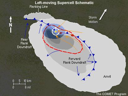
14 Other Supercell Features (FFD, RFD and Flanking Line)

15 Supercell Visual Features
16 Supercell Types and Features
17 Supercell Classifications There are four categories of supercell storms 1. Classic Supercells 2. Heavy Precipitation (HP) Supercells 3. Low Precipitation (LP) Supercells and 4. Shallow (a.k.a. Mini or Low-topped) Supercells All of these may be either Right-moving, Leftmoving, or both (Splitting storms)
18 Classic Supercells Wedge-shaped, generally isolated longlived storms with rotating updrafts Often possess a WER or BWER and/or a hook echo Frequent producers of severe weather including large hail, strong winds, tornadoes, and heavy rain

19 HP Supercells More common east of the Plains states Produce heavier rain than classic supercells and tend to be less isolated than other supercell types Are capable of producing extreme hail falls, tornadoes, prolonged downburst winds and flash flooding

20 Have a kidney bean shape on radar Stages 3 4, and 5 HP Supercell Evolution

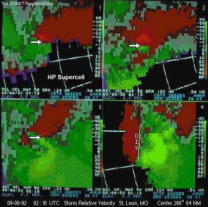
21 HP Supercell Example

22 Most common along the dryline of west Texas and in the High Plains Are generally smaller in diameter than classic supercells LP Supercells

23 Still capable of producing severe weather especially large hail and to a lesser extent tornadoes, although funnel clouds are common. LP Supercells

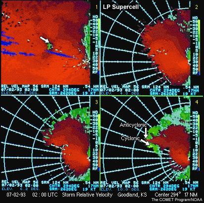
24 LP Supercell Example
25 Shallow Supercells Are much smaller both horizontally and vertically than the other supercell types. These mini storms may be as small as only 20,000 ft (~6 km) tall with much smaller horizontal dimensions than classic varieties being as small as 6 km in diameter!

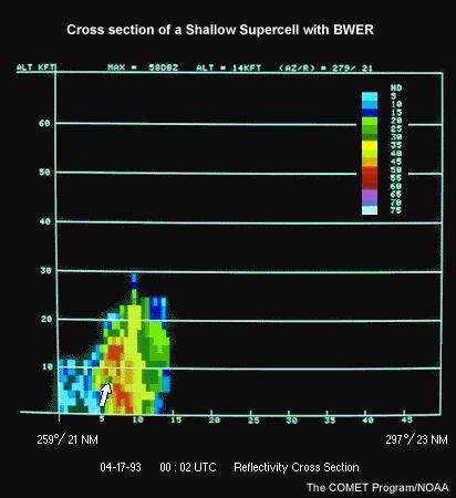
26 Shallow Supercell Example
27 Supercell Environments and Evolution

28 Favorable conditions conducive to supercells often occur with identifiable synoptic patterns The favorable ingredients that support supercells in these environments are lots of instability and shear Synoptic Patterns
29 Environmental Factors Because they are so long-lived and intense it is highly desirable to be able to determine in advance if supercells are likely Luckily the length and shape of a hodograph can be very helpful in making this determination! Strong and deep vertical wind shear values (> =25 m/s or ~50 kts over the lowest ~6 km AGL) tend to be associated with supercell formation

30 Supercell Shear: Splitting Storms
31 Evolution with a Straight Hodograph

32 Supercell Shear: Right-movers
33 Evolution with a Clockwise-Curved Hodograph

34 Supercell Shear: Left-movers

35 Evolution with a Counterclockwise-Curved Hodograph
36 Impact of CAPE Supercells, like other severe thunderstorms, usually occur with significant instability (CAPE values J/kg or more) Very severe storms with some supercell characteristics can also form when shear values are negligible, but CAPE values are extremely large (> 5,000 J/kg). In some highly dynamic environments supercells can form with a minimal amount of CAPE and with tremendous low-level shear*.
37 Cape and Shear / BRN However, supercells most commonly form when the environmental vertical wind shear and instability are balanced BRN values between are generally associated with supercell storms
38 Shallow Supercell Environments Mini supercells occur when CAPE is shallow and values are small. They most typically arise in two very different environments 1) with land-falling hurricanes and 2) in wintertime high shear low buoyancy winter situations

39 Shallow Supercell Environments The thing that these two environments have in common is extreme low-level shear values (sometimes 60 kts over the lowest 2-3 km AGL!)

40 Supercells with Bow Echoes Bow echo and supercell
41 Important Supercell Processes

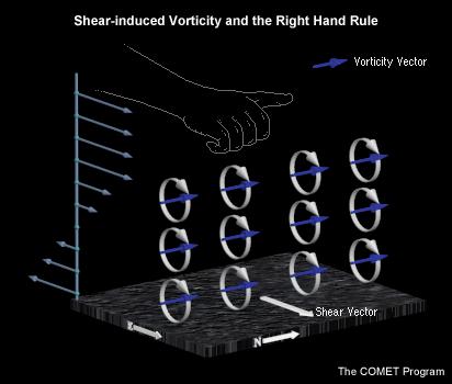
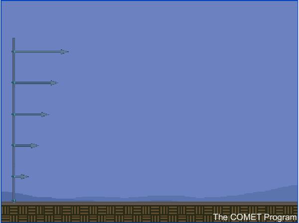
42 When the vertical wind profile is sheared, horizontal vorticity is present in the environment. We can visualize this vorticity if we imagine the rotation that would be imparted to paddle wheels placed in the environment. Shear Creating Vorticity

43 Vertical wind shear and buoyancy gradients across the cloud act to tilt the convective tower in the downshear direction. For a given amount of shear, a stronger, updraft will not tilt as much as a weaker updraft simply because its vertical momentum is stronger. Storm Tilt

44 Storm Tilt (cont.) The precipitation in a storm tilted by shear will largely fall downshear of the updraft, producing a distinctive reflectivity pattern with a tight gradient near the updraft. Even though the precipitation is not falling back on the updraft as it does for non-sheared convection, this does not appreciably extend the life of the storm. The cold pool produced by the precipitation can still kill the storm.
45 Vorticity

46 Rotation Creates Low-Pressure It is also important to understand that at this scale, wherever there is rotation, low pressure is induced regardless of the direction of the rotation.

47 Tilting Process
 also increases rotation Stretching")
48 Vertical stretching (like by a strong updraft) also increases rotation Stretching Process

49 Splitting Process
50 Splitting Storm Motion
51 Additional Effect

52 Comparing Pressure Patterns

53 Right-Moving Supercell Processes
54 Operational Issues with Supercell Storms

55 Supercell Locations in Squall Lines Supercells within lines tend to become bow echoes, but cells at the ends of squall lines can remain supercellular for long periods of time
56 Detecting Shallow Supercells Shallow supercells present a particularly difficult forecasting challenge because they are accompanied by the same severe weather elements (including tornadoes) as their bigger counterparts, but are much more difficult to detect at any appreciable distance from the radar. Also, they often catch forecasters off guard because they can occur even in low buoyancy environments where typical severe weather indices would not indicate the potential for severe weather.
57 Tornadoes with Supercells Note that a mid-level mesocyclone, and sometimes a hook echo, may be present for a considerable length of time before tornadogenesis, IF a tornado even occurs. Recent research has shown that in the U.S. our best guess is that only 20-30% of supercell storms produce tornadoes. However, the same study found that such storms almost always produced severe weather in the form of hail or high winds.

58 Tornado Evolution with Supercells
59 Supercell Longevity Recent research has shown that especially long-lived supercells ( > 4 hrs) tend to develop and evolve in environments with deeper stronger shear than supercells that live for 2 hours or less The same study has shown that thankfully from a forecast perspective, the longest lived supercells tend to be more isolated than the shorter lived supercells
60 Supercell Demise All good things must come to and end though, and eventually something kills even supercell storms. The two most common reasons for a supercell to decay include: 1. its own cold pool eventually cutting off the supply of potentially unstable air or 2. moving into an unfavorable environment Colliding with other convective storms can also disrupt supercells.
61 Summary Supercell storms are those storms with longlived cores and rotating updrafts Supercells tend to have distinctive radar reflectivity patterns a different storm motion than other nearby ordinary cells Supercells are frequent producers of large hail, strong winds, and tornadoes.
62 Summary (cont) There are four categories of supercell storms 1. Classic Supercells 2. Heavy Precipitation (HP) Supercells 3. Low Precipitation (LP) Supercells and 4. Shallow (a.k.a. Mini or Low-topped) Supercells - All of which may move to the right or left of the mean wind, or both (Splitting storms) depending on the hodograph shape
63 Summary (cont) Supercell structure and evolution depend on the characteristics of the environmental buoyancy and shear Supercells are likely when the environmental wind shear is strong (> 50 kts over 0-6 km AGL)
64 References COMET CD-Module, Anticipating Convective Storm Structure and Evolution with online key points at Bluestein, H.B., and P.C. Bancos, 2002: The vertical profile of wind and temperature in cyclones and anticyclones over the eastern two-thrids of the United States: A climatology. Mon. Wea. Rev., 130, Bluestein, H.B., and C.R. Parks, 1983: A synoptic and photographic climatology of low-precipitation severe thunderstorms in the southern plains. Mon. Wea. Rev., 111, Bluestein, H.B., and G.R. Woodall, 1990: Doppler radar analysis of a lowprecipitation severe storm. Mon. Wea. Rev., 118, Bunkers, 2002?: Vertical wind shear associated with left-moving supercells. Submitted Wea. Forecasting. Bunkers, M.J., J.S. Johnson, J.M. Grzywacz, L.J. Czepyha and B.A. Klimowski, 2002: A Preliminary Investigation of Supercell Longevity. Preprints, 21st Conf. on Severe Local Storms, San Antonia, Texas, Amer. Meteor. Soc., TBD.
65 References (cont) Burgess, D.W., and L.R. Lemon, 1990: Severe thunderstorm detection by radar. Radar in Meteorology, D. Atlas, Ed., Amer. Meteor. Soc., Doswell, C.A., III, 1991: A review for forecasters on the application of hodographs to forecasting severe thunderstorms. Natl. Wea. Dig., 16 (1), Doswell, C.A., III, A.R. Moller, and R. Przybylinski, 1990: A unified set of conceptual models for variations on the supercell theme. Preprints, 16th Conf. on Severe Local Storms, Kananaskis Park, Alta., Canada, Amer. Meteor. Soc., Klemp, J.B., 1987: Dynamics of tornadic thunderstorms. Ann. Rev. Fluid Mech., 19, Moller, A.R., C.A. Doswell III, and R. Przybylinski, 1990: Highprecipitation supercells: A conceptual model and documentation. Preprints, 16th Conf. on Severe Local Storms, Kananaskis Park, Canada, Amer. Meteor. Soc., Moller, A.R., C.A. Doswell III, M.P. Foster, and G.R. Woodall, 1994: The operational recognition of supercell thunderstorm environments and storm structures. Wea. Forecasting, 9,
66 References (cont) Rotunno, R., 1993: Supercell thunderstorm modeling and theory. Geo. Monograph 79, Rotunno, R., and J.B. Klemp, 1982: The influence of the shear-induced pressure gradient on thunderstorm motion. Mon. Wea. Rev., 110, Rotunno, R., and J. Klemp, 1985: On the rotation and propagation of simulated supercell thunderstorms. J. Atmos. Sci., 42, Weisman, M.L., and J.B. Klemp, 1982: The dependence of numerically simulated convective storms on vertical wind shear and buoyancy. Mon. Wea. Rev., 110, Weisman, M.L., and J.B. Klemp, 1984: The structure and classification of numerically simulated convective storms in directionally varying wind shears. Mon. Wea. Rev., 112,
Chapter 3 Convective Dynamics Part VI. Supercell Storms. Supercell Photos
 Chapter 3 Convective Dynamics Part VI. Supercell Storms Photographs Todd Lindley (This part contains materials taken from UCAR MCS training module) Supercell Photos 1 Introduction A supercel storm is defined
Mesoscale Convective Systems. The COMET Program March 2002
 Mesoscale Convective Systems The COMET Program March 2002 Overview! Introduction to MCSs! Squall Lines! Bow Echoes! Mesoscale Convective Complexes Introduction Definition! Mesoscale convective systems
11A.2 Forecasting Short Term Convective Mode And Evolution For Severe Storms Initiated Along Synoptic Boundaries
 11A.2 Forecasting Short Term Convective Mode And Evolution For Severe Storms Initiated Along Synoptic Boundaries Greg L. Dial and Jonathan P. Racy Storm Prediction Center, Norman, Oklahoma 1. Introduction
Chapter 3 Convective Dynamics 3.4. Bright Bands, Bow Echoes and Mesoscale Convective Complexes
 Chapter 3 Convective Dynamics 3.4. Bright Bands, Bow Echoes and Mesoscale Convective Complexes Photographs Todd Lindley Bright band associated with stratiform precipitation in a squall line system 1 Bright
24 TH CONFERENCE ON SEVERE LOCAL STORMS, OCTOBER 2008, SAVANNAH, GEORGIA
 P9.13 SUPER-RESOLUTION POLARIMETRIC OBSERVATIONS OF A CYCLIC TORNADIC SUPERCELL MATTHEW R. KUMJIAN*, ALEXANDER V. RYZHKOV, AND VALERY M. MELNIKOV Cooperative Institute for Mesoscale Meteorological Studies,
Tornadogenesis in Supercells: The Three Main Ingredients. Ted Funk
 Tornadogenesis in Supercells: The Three Main Ingredients Ted Funk NWS Louisville, KY Spring 2002 Environmental Parameters Supercells occur within environments exhibiting several wellknown characteristics
NOAA S National Weather Service
 NOAA S National Weather Service Elite Concepts of Severe Storm Spotting 2011 Rusty Kapela Milwaukee/Sullivan www.weather.gov/mkx Elite Spotter Outline Review Types of T storms Tornadic Supercell Classic,
Investigation of Supercells in China : Environmental and Storm Characteristics
 11A.6 Investigation of Supercells in China : Environmental and Storm Characteristics Xiaoding Yu Xiuming Wang Juan Zhao Haiyan Fei ( China Meteorological Administration Training Center) Abstract Based
4/18/2010. National Weather Service. Severe Weather Forecasting: A Western North Carolina Case Study
 National Weather Service Severe Weather Forecasting: A Western North Carolina Case Study Laurence G. Lee Science and Operations Officer National Weather Service Greer, SC Plus 13 River Forecast Centers
Chapter 14 Thunderstorm Fundamentals
 Chapter overview: Thunderstorm appearance Thunderstorm cells and evolution Thunderstorm types and organization o Single cell thunderstorms o Multicell thunderstorms o Orographic thunderstorms o Severe
Evolution and Maintenance of the June 2003 Nocturnal Convection
 Evolution and Maintenance of the 22-23 June 2003 Nocturnal Convection Jerilyn Billings NOAA/NWS Wichita, KS August 6 th, 2011 Work Completed at North Carolina State University for MS Thesis During the
Chapter 3 Convective Dynamics Part V ñ Bright Bands, Bow Echoes and MCCs. Bright band associated with stratiform precipitation in a squall line system
 Chapter 3 Convective Dynamics Part V ñ Bright Bands, Bow Echoes and MCCs Photographs Todd Lindley (This part contains materials taken from UCAR MCS training module) Bright band associated with stratiform
10.2 TORNADIC MINI-SUPERCELLS IN NORTHERN CANADA
 10.2 TORNADIC MINI-SUPERCELLS IN NORTHERN CANADA Patrick J. McCarthy*, Sandra Massey Prairie and Arctic Storm Prediction Centre Meteorological Service of Canada Dave Patrick Hydrometeorological and Arctic
Severe Thunderstorms. MET 200 Lecture 24 Flooding in Hawaii and Intro to Severe Thunderstorms. MET 200 Lecture 24 Severe Thunderstorms.
 MET 200 Lecture 24 Severe Thunderstorms Damage Swath 1 2 MET 200 Lecture 24 Flooding in Hawaii and Intro to Severe Thunderstorms Severe Thunderstorms Kona Lows Cause more flash floods in Hawaii than any
P10.1 TORNADOGENESIS IN A SIMULATED HP SUPERCELL
 Preprints, 21 st Conference on Severe Local Storms 12-16 August 2002, San Antonio, Texas P10.1 TORNADOGENESIS IN A SIMULATED HP SUPERCELL 1. INTRODUCTION Catherine A. Finley * Department of Earth Sciences
Thunderstorm Dynamics. Helicity and Hodographs and their effect on thunderstorm longevity. Bluestein Vol II. Page
 Thunderstorm Dynamics Helicity and Hodographs and their effect on thunderstorm longevity Bluestein Vol II. Page471-476. Dowsell, 1991: A REVIEW FOR FORECASTERS ON THE APPLICATION OF HODOGRAPHS TO FORECASTING
12.2 MESOVORTICES FORMED WITHIN BOW ECHOES: THEIR GENESIS AND SENSITIVITY TO THE ENVIRONMENT AND SYSTEM COLD POOL
 12.2 MESOVORTICES FORMED WITHIN BOW ECHOES: THEIR GENESIS AND SENSITIVITY TO THE ENVIRONMENT AND SYSTEM COLD POOL Nolan T. Atkins and Mike St. Laurent Lyndon State College, Lyndonville, Vermont 1. INTRODUCTION
Meteorology Lecture 19
 Meteorology Lecture 19 Robert Fovell rfovell@albany.edu 1 Important notes These slides show some figures and videos prepared by Robert G. Fovell (RGF) for his Meteorology course, published by The Great
David O. Blanchard* and Brian A. Klimowski National Weather Service, Flagstaff, Arizona
 P12.1 SUPERCE EVOUTION IN ENVIRONMENTS WITH UNUSUA HODOGRAPHS David O. Blanchard* and Brian A. Klimowski National Weather Service, Flagstaff, Arizona 1. INTRODUCTION The events that transpired across northern
Tornadoes forecasting, dynamics and genesis. Mteor 417 Iowa State University Week 12 Bill Gallus
 Tornadoes forecasting, dynamics and genesis Mteor 417 Iowa State University Week 12 Bill Gallus Tools to diagnose severe weather risks Definition of tornado: A vortex (rapidly rotating column of air) associated
Storm-Relative Flow and its Relationship to Low-Level Vorticity in Simulated Storms
 TH CONF. ON SEVERE LOCAL STORMS, 15. 1 Storm-Relative Flow and its Relationship to Low-Level Vorticity in Simulated Storms Cody Kirkpatrick University of Alabama in Huntsville Eugene W. McCaul, Jr. Universities
Tornado Dynamics. Readings:
 Tornado Dynamics Readings: Klemp (1987) Dynamics of Tornadic Thunderstorms (handout) Bluestein Vol II. Section 3.4.8. Rotunno, R., 1986: Tornadoes and tornadogenesis. In: P. Ray (Editor), Mesoscale Meteorology
P12.7 MESOCYCLONE AND RFD INDUCED DAMAGING WINDS OBSERVED IN THE 27 MAY 2004 SOUTHWEST OHIO SUPERCELL
 P12.7 MESOCYCLONE AND RFD INDUCED DAMAGING WINDS OBSERVED IN THE 27 MAY 2004 SOUTHWEST OHIO SUPERCELL John T. DiStefano* National Weather Service Office, Wilmington, Ohio 1. INTRODUCTION During the early
SIMULATED EFFECTS OF AN ISOLATED SUPERCELL ON THE EVOLUTION OF A NEARBY SQUALL LINE
 5.55 SIMULATED EFFECTS OF AN ISOLATED SUPERCELL ON THE EVOLUTION OF A NEARBY SQUALL LINE Jacey Wipf* and Adam French South Dakota School of Mines and Technology 1. INTRODUCTION 2. METHODOLOGY Operational
Thunderstorms. Ordinary Cell Thunderstorms. Ordinary Cell Thunderstorms. Ordinary Cell Thunderstorms 5/2/11
 A storm containing lightning and thunder; convective storms Chapter 14 Severe thunderstorms: At least one: large hail wind gusts greater than or equal to 50 kt Tornado 1 2 Ordinary Cell Ordinary Cell AKA
Tornadoes forecasting, dynamics and genesis. Mteor 417 Iowa State University Week 12 Bill Gallus
 Tornadoes forecasting, dynamics and genesis Mteor 417 Iowa State University Week 12 Bill Gallus Tools to diagnose severe weather risks Definition of tornado: A vortex (rapidly rotating column of air) associated
MET Lecture 26 Tornadoes I
 MET 4300 Lecture 26 Tornadoes I A Large Tornado approaches Lyndon, Kansas, on May 8, 2003 Outline Definition, life cycle Tornado formation within supercells Tornado formation within nonsupercell thunderstorms
Tornado Occurrences. Tornadoes. Tornado Life Cycle 4/12/17
 Chapter 19 Tornadoes Tornado Violently rotating column of air that extends from the base of a thunderstorm to the ground Tornado Statistics Over (100, 1000, 10000) tornadoes reported in the U.S. every
Severe Thunderstorms
 Lecture 26 Severe Thunderstorms NWS Criteria Environment Structure Climatology 1 Severe Thunderstorms NWS Criteria Environment Structure Climatology 2 Severe Thunderstorms: NWS Criteria NWS Criteria: to
Storm-Relative Flow and its Relationship to Low-Level Vorticity in Simulated Storms
 TH CONF. ON SEVERE LOCAL STORMS, 15. 1 Storm-Relative Flow and its Relationship to Low-Level Vorticity in Simulated Storms Cody Kirkpatrick University of Alabama in Huntsville Eugene W. McCaul, Jr. Universities
P8.14 CLASSIC AND HP MINI-SUPERCELLS IN SOUTHEAST OREGON AND SOUTHWEST IDAHO ON 3 MAY
 P8.14 CLASSIC AND HP MINI-SUPERCELLS IN SOUTHEAST OREGON AND SOUTHWEST IDAHO ON 3 MAY 2009 Stephen S. Parker* National Weather Service, Boise, ID 1. INTRODUCTION During the early afternoon hours of 3 May
NOTES AND CORRESPONDENCE. Aspects of a Tornadic Left-Moving Thunderstorm of 25 May 1999
 614 WEATHER AND FORECASTING NOTES AND CORRESPONDENCE Aspects of a Tornadic Left-Moving Thunderstorm of 25 May 1999 JOHN F. DOSTALEK Cooperative Institute for Research in the Atmosphere, Colorado State
NOAA S National Weather Service
 NOAA S National Weather Service Night Spotting Advanced Concepts of Severe Storm Spotting 2012 Rusty Kapela Milwaukee/Sullivan Weather.gov/milwaukee Problems Spotters Encounter Spotters can only see a
P10.18 ORIGINS OF THE GRANITE FALLS, MN TORNADO, JULY 25, 2000 REVISITED
 P10.18 ORIGINS OF THE GRANITE FALLS, MN TORNADO, JULY 25, 2000 REVISITED Doug Dokken, Rich Naistat, Bill Togstad, and Kurt Scholz. Keenan Weise, John Nelson, Luke Edholm, and Pat Shanahan. 1. INTRODUCTION
Solutions to Comprehensive Final Examination Given on Thursday, 13 December 2001
 Name & Signature Dr. Droegemeier Student ID Meteorology 1004 Introduction to Meteorology Fall, 2001 Solutions to Comprehensive Final Examination Given on Thursday, 13 December 2001 BEFORE YOU BEGIN!! Please
Meteorology Lecture 18
 Meteorology Lecture 18 Robert Fovell rfovell@albany.edu 1 Important notes These slides show some figures and videos prepared by Robert G. Fovell (RGF) for his Meteorology course, published by The Great
Seeing Supercells as Heavy Rain Producers
 Paper 2A.7. Appeared in: Preprints, 14 th Conf. Hydrology (Dallas, TX - 10-15 January 1998), Amer. Meteor. Soc., 73-76. Seeing Supercells as Heavy Rain Producers Charles A. Doswell III NOAA/National Severe
1 of 7 Thunderstorm Notes by Paul Sirvatka College of DuPage Meteorology. Thunderstorms
 1 of 7 Thunderstorm Notes by Paul Sirvatka College of DuPage Meteorology Thunderstorms There are three types of thunderstorms: single-cell (or air mass) multicell (cluster or squall line) supercell Although
contact with ground for 1 hour plus, starting 1500 MDT moved N., covered about 37 km width varied m
 Goal for today: Finish Ch. 11 Lightning, Thunder & Tornadoes 16 Nov., 2011 Edmonton tornado 31 July 1987 contact with ground for 1 hour plus, starting 1500 MDT moved N., covered about 37 km width varied
Weather Systems III: Thunderstorms and Twisters
 Weather Systems III: Thunderstorms and Twisters Review 1. Definition of airmasses? Bergeron classification of air masses 2. Surface weather analysis: Station model, wind speed code, present weather 3.
Severe Weather Event of 13 July 2014
 Severe Weather Event of 13 July 2014 By Richard H. Grumm and Elyse M. Colbert National Weather Service State College, PA 1. Overview Severe weather affected the eastern United States (Fig. 1) from northwestern
13.5 DOPPLER RADAR ANALYSIS OF THE 28 APRIL 2002 LA PLATA, MD TORNADIC SUPERCELL
 13.5 DOPPLER RADAR ANALYSIS OF THE 28 APRIL 2002 LA PLATA, MD TORNADIC SUPERCELL David R. Manning* and Steven M. Zubrick NOAA/National Weather Service, Sterling, Virginia 1. Introduction A severe weather
P10.4 EXAMINATION OF TORNADIC AND NON-TORNADIC SUPERCELLS IN SOUTHWEST VIRGINIA ON 28 APRIL 2002
 P10.4 EXAMINATION OF TORNADIC AND NON-TORNADIC SUPERCELLS IN SOUTHWEST VIRGINIA ON 28 APRIL 2002 Steve Keighton*, Kenneth Kostura, and Chris Liscinsky NOAA/National Weather Service Blacksburg, VA 1. INTRODUCTION
CHAPTER 11 THUNDERSTORMS AND TORNADOES MULTIPLE CHOICE QUESTIONS
 CHAPTER 11 THUNDERSTORMS AND TORNADOES MULTIPLE CHOICE QUESTIONS 1. A thunderstorm is considered to be a weather system. a. synoptic-scale b. micro-scale c. meso-scale 2. By convention, the mature stage
Part 7. Conceptual Models of Cumulonimbi
 Part 7. Conceptual Models of Cumulonimbi 7.1 Ordinary Cumulonimbus Clouds The ordinary cumulonimbus cloud or thunderstorm is distinguished by a well-defined lifecycle, illustrated in Figure 7.1 that lasts
Tornadoes. tornado: a violently rotating column of air
 Tornadoes tornado: a violently rotating column of air Tornadoes What is the typical size of a tornado? What are typical wind speeds for a tornado? Five-stage life cycle of a tornado Dust Swirl Stage Tornado
Chapter 8 cont. Clouds and Storms. Spring 2018
 Chapter 8 cont. Clouds and Storms Spring 2018 Clouds and Storms Clouds cover ~ 50% of earth at any time. Clouds are linked to a number of condensation processes. Cloud morphology, cloud types, associated
Ray Wolf * NOAA / National Weather Service Davenport (Quad Cities), Iowa 3. CASES
, Iowa 3. CASES") 8B.4 ANALYSIS OF CELL MERGERS LEADING TO TORNADOGENESIS USING 3D RENDERED RADAR IMAGERY Ray Wolf * NOAA / National Weather Service Davenport (Quad Cities), Iowa 1. INTRODUCTION Convective cell mergers
8B.4 ANALYSIS OF CELL MERGERS LEADING TO TORNADOGENESIS USING 3D RENDERED RADAR IMAGERY Ray Wolf * NOAA / National Weather Service Davenport (Quad Cities), Iowa 1. INTRODUCTION Convective cell mergers
Houze sections 7.4, 8.3, 8.5, Refer back to equations in Section 2.3 when necessary.
 Theory of Thunderstorm Dynamics Houze sections 7.4, 8.3, 8.5, Refer back to equations in Section 2.3 when necessary. Bluestein Vol. II section 3.4.6. Review article "Dynamics of Tornadic Thunderstorms"
PICTURE OF THE MONTH. Some Frequently Overlooked Severe Thunderstorm Characteristics Observed on GOES Imagery: A Topic for Future Research
 1529 PICTURE OF THE MONTH Some Frequently Overlooked Severe Thunderstorm Characteristics Observed on GOES Imagery: A Topic for Future Research JOHN F. WEAVER AND DAN LINDSEY NOAA/NESDIS/RAMM Team, Cooperative
P5.5 WSR-88D MANIFESTATIONS OF THE OWL HORN SIGNATURE. Matthew R. Kramar National Weather Service WFO Amarillo, TX
 P5.5 WSR-88D MANIFESTATIONS OF THE OWL HORN SIGNATURE Matthew R. Kramar National Weather Service WFO Amarillo, TX 1. INTRODUCTION In prior conference forums, the Owl Horn Signature (OHS) was presented
Kenneth L. Pryor* and Gary P. Ellrod Center for Satellite Applications and Research (NOAA/NESDIS) Camp Springs, MD
 Camp Springs, MD") P1.57 GOES WMSI PROGRESS AND DEVELOPMENTS Kenneth L. Pryor* and Gary P. Ellrod Center for Satellite Applications and Research (NOAA/NESDIS) Camp Springs, MD 1. INTRODUCTION A multi-parameter index has
P1.57 GOES WMSI PROGRESS AND DEVELOPMENTS Kenneth L. Pryor* and Gary P. Ellrod Center for Satellite Applications and Research (NOAA/NESDIS) Camp Springs, MD 1. INTRODUCTION A multi-parameter index has
P3.17 THE DEVELOPMENT OF MULTIPLE LOW-LEVEL MESOCYCLONES WITHIN A SUPERCELL. Joshua M. Boustead *1 NOAA/NWS Weather Forecast Office, Topeka, KS
 P3.17 THE DEVELOPMENT OF MULTIPLE LOW-LEVEL MESOCYCLONES WITHIN A SUPERCELL Joshua M. Boustead *1 NOAA/NWS Weather Forecast Office, Topeka, KS Philip N. Schumacher NOAA/NWS Weather Forecaster Office, Sioux
Thunderstorm: a cumulonimbus cloud or collection of cumulonimbus clouds featuring vigorous updrafts, precipitation and lightning
 Thunderstorm: a cumulonimbus cloud or collection of cumulonimbus clouds featuring vigorous updrafts, precipitation and lightning Thunderstorm: a cumulonimbus cloud or collection of cumulonimbus clouds
1st Tornado Photograph
 Lecture 26 Part II Tornados Environment Storm Structure Life Cycle Source of Spin Forecasting Climatology Damage Marilee Thomas of Beaver City, NE took this photograph of her daughter Audra about two miles
DOPPLER RADAR AND STORM ENVIRONMENT OBSERVATIONS OF A MARITIME TORNADIC SUPERCELL IN SYDNEY, AUSTRALIA
 155 DOPPLER RADAR AND STORM ENVIRONMENT OBSERVATIONS OF A MARITIME TORNADIC SUPERCELL IN SYDNEY, AUSTRALIA Harald Richter *, Alain Protat Research and Development Branch, Bureau of Meteorology, Melbourne,
Houze sections 7.4, 8.3, 8.5, Refer back to equations in Section 2.3 when necessary.
 Thunderstorm Dynamics Houze sections 7.4, 8.3, 8.5, Refer back to equations in Section.3 when necessary. Bluestein Vol. II section 3.4.6. Review article "Dynamics of Tornadic Thunderstorms" by Klemp handout.
Effects of microphysical drop size distribution on tornadogenesis in supercell thunderstorms
 GEOPHYSICAL RESEARCH LETTERS, VOL. 35,, doi:10.1029/2008gl035866, 2008 Effects of microphysical drop size distribution on tornadogenesis in supercell thunderstorms Nathan Snook 1 and Ming Xue 1 Received
The Earth System - Atmosphere III Convection
 The Earth System - Atmosphere III Convection Thunderstorms 1. A thunderstorm is a storm that produces lightning (and therefore thunder) 2. Thunderstorms frequently produce gusty winds, heavy rain, and
Observations of a Severe, Left-Moving Supercell on 4 May 2003
 FEBRUARY 2005 L I N D S E Y A N D B U NKERS 15 Observations of a Severe, Left-Moving Supercell on 4 May 2003 DANIEL T. LINDSEY * Cooperative Institute for Research in the Atmosphere, Fort Collins, Colorado
Steve Keighton * and Steve Nogueira NOAA/NWS Blacksburg, VA. Nicole Belk NOAA/NWS Charleston, WV
 P5.17 SYNOPTIC AND MESOSCALE ANALYSIS OF THE 9 AUGUST 2000 APPALACHIAN-CROSSING DERECHOS Steve Keighton * and Steve Nogueira NOAA/NWS Blacksburg, VA Nicole Belk NOAA/NWS Charleston, WV 1. INTRODUCTION
WARM SECTOR TORNADOES WITHOUT DISCERNIBLE SURFACE BOUNDARIES AND WITH MINIMAL DEEP LAYER SHEA
 2.1 WARM SECTOR TORNADOES WITHOUT DISCERNIBLE SURFACE BOUNDARIES AND WITH MINIMAL DEEP LAYER SHEA * Joshua M. Boustead and Philip N. Schumacher National Weaer Service Sioux Falls, SD 1. INTRODUCTION On
P12.6 Multiple Modes of Convection in Moderate to High Wind Shear Environments
 P12.6 Multiple Modes of Convection in Moderate to High Wind Shear Environments Adam J. French and Matthew D. Parker North Carolina State University, Raleigh, North Carolina 1. INTRODUCTION A principle
Examining Relationships in Wind Speeds and other Parameters with Tornadic and Non-tornadic Supercells
 Examining Relationships in Wind Speeds and other Parameters with Tornadic and Non-tornadic Supercells Ron Harris Candidate for B.S. Degree in Meteorology State University of New York, College at Oswego
RODGER A. BROWN NOAA/National Severe Storms Laboratory, Norman, OK
 Preprints, 25th Intern. Conf. on Interactive Information and Processing Systems, Phoenix, AZ, Amer. Meteor. Soc., January 2009 9B.3 Progress Report on the Evolutionary Characteristics of a Tornadic Supercell
Practical Use of the Skew-T, log-p diagram for weather forecasting. Primer on organized convection
 Practical Use of the Skew-T, log-p diagram for weather forecasting Primer on organized convection Outline Rationale and format of the skew-t, log-p diagram Some basic derived diagnostic measures Characterizing
8A.6 MESOCYCLONE AND RFD EVOLUTION IN SIMULATED SUPERCELL STORMS WITH VARYING WIND PROFILES
 8A.6 MESOCYCLONE AND RFD EVOLUTION IN SIMULATED SUPERCELL STORMS WITH VARYING WIND PROFILES Matthew S. Van Den Broeke Jerry M. Straka University of Oklahoma, Norman, Oklahoma Erik Rasmussen Rasmussen Systems,
The Role of Downward Momentum Transport in the Generation of Convective Downbursts
 The Role of Downward Momentum Transport in the Generation of Convective Downbursts Ken Pryor METO 658B Abstract A downburst index has been developed to assess the magnitude of convective downbursts associated
Thunderstorm: a cumulonimbus cloud or collection of cumulonimbus clouds featuring vigorous updrafts, precipitation and lightning
 Thunderstorm: a cumulonimbus cloud or collection of cumulonimbus clouds featuring vigorous updrafts, precipitation and lightning Thunderstorms are responsible for most of what we refer to as severe weather,
1. INTRODUCTION GSP Dr, Greer, SC tropical cyclones. 1 This study did not include tornadoes associated with
 4.5 OBSERVATIONS OF A NON-SUPERCELL TORNADIC THUNDERSTORM FROM A TERMINAL DOPPLER WEATHER RADAR Justin D. Lane * and Patrick D. Moore NOAA/National Weather Service Greer, SC 1. INTRODUCTION Despite numerous
Examination of Derecho Environments Using Proximity Soundings
 JUNE 2001 EVANS AND DOSWELL 329 Examination of Derecho Environments Using Proximity Soundings JEFFRY S. EVANS Storm Prediction Center, Norman, Oklahoma CHARLES A. DOSWELL III National Severe Storms Laboratory,
Test Form: A Key Final Exam: Spring 2011
 Test Form: A Key Final Exam: Spring 2011 Instructions: Write your name (last name and first name) on your bubble sheet. Write your student identification number on the bubble sheet, and carefully and completely
5B.2 VARIABILITY IN THE KINEMATIC STRUCTURE OF SUPER TUESDAY STORMS
 5B.2 VARIABILITY IN THE KINEMATIC STRUCTURE OF SUPER TUESDAY STORMS Todd A. Murphy* & Kevin R. Knupp University of Alabama in Huntsville, Huntsville, Alabama 1. INTRODUCTION Since the advent of multiple
10/21/2012. Chapter 10 Thunderstorms. Part II. Growth and Development of ordinary Cell Thunderstorms Thunderstorm Electrification.
 Chapter 10 Thunderstorms Part I Growth and Development of ordinary Cell Thunderstorms Thunderstorm Electrification Tornadoes Part II Simplified model depicting the life cycle of an ordinary thunderstorm
P10.2 SUBTLE RADAR SIGNATURES IN THE WEST BROOKFIELD, MA TORNADO OF 23 JULY 2002
 P10.2 SUBTLE RADAR SIGNATURES IN THE WEST BROOKFIELD, MA TORNADO OF 23 JULY 2002 Glenn A. Field and David R. Vallee NOAA/National Weather Service Forecast Office, Taunton, MA 1. INTRODUCTION Tornadic storms
ATS 351, Spring 2010 Lab #11 Severe Weather 54 points
 ATS 351, Spring 2010 Lab #11 Severe Weather 54 points Question 1 (10 points): Thunderstorm development a) Sketch and describe the stages of development of a single cell thunderstorm. About how long does
P12.7 THE ROLE OF A SURFACE BOUNDARY AND MULTIPLE CELL-MERGERS IN THE DEVELOPMENT OF THE 21 APRIL 2003 TORNADO IN UPSTATE SOUTH CAROLINA
 P12.7 THE ROLE OF A SURFACE BOUNDARY AND MULTIPLE CELL-MERGERS IN THE DEVELOPMENT OF THE 21 APRIL 2003 TORNADO IN UPSTATE SOUTH CAROLINA 1. INTRODUCTION Bryan McAvoy NOAA/National Weather Service Greer,
Proximity sounding analysis for derechos and supercells: an assessment of similarities and differences
 Atmospheric Research 67 68 (2003) 117 133 www.elsevier.com/locate/atmos Proximity sounding analysis for derechos and supercells: an assessment of similarities and differences Charles A. Doswell III a,
Idealized simulations of aerosol influences on tornadogenesis
 Click Here for Full Article GEOPHYSICAL RESEARCH LETTERS, VOL. 35, L23806, doi:10.1029/2008gl035617, 2008 Idealized simulations of aerosol influences on tornadogenesis David G. Lerach, 1 Brian J. Gaudet,
Reprinted from: November 1993 Bull. Amer. Meteor. Soc., 74,
 Reprinted from: November 1993 Bull. Amer. Meteor. Soc., 74, 2213 2218 Comments on Anomalous Cloud-to- Ground Lighting in an F5 Tornadoproducing Supercell Thunderstorm on 28 August 1990 In his very interesting
7A.5 The Interaction of a HP Supercell Thunderstorm and Bow Echo to Produce a Prolonged Severe Wind Event in East Central Missouri
 7A.5 The Interaction of a HP Supercell Thunderstorm and Bow Echo to Produce a Prolonged Severe Wind Event in East Central Missouri James E. Sieveking and Ron W. Przybylinski NOAA/National Weather Service
High-Resolution RUC CAPE Values and Their Relationship to Right Turning Supercells
 High-Resolution RUC CAPE Values and Their Relationship to Right Turning Supercells ANDREW H. MAIR Meteorology Program, Iowa State University, Ames, IA Mentor: Dr. William A. Gallus Jr. Department of Geological
End of heat-event severe event of 7 July 2012
 End of heat-event severe event of 7 July 2012 Richard H. Grumm And Elyse Colbert National Weather Service Office State College, PA 16803 1. Overview A widespread severe weather event affected Pennsylvania
HAZARDOUS WEATHER 1. Dr. Julie Laity Geography 266
 HAZARDOUS WEATHER 1 Dr. Julie Laity Geography 266 Violent Weather Thunderstorms Atmospheric turbulence Lightning and thunder Hail Derechos Tornadoes Tornado measurement and science Tropical Cyclones Hurricanes
A more detailed and quantitative consideration of organized convection: Part I Cold pool dynamics and the formation of squall lines
 A more detailed and quantitative consideration of organized convection: Part I Cold pool dynamics and the formation of squall lines Note: Lecture notes presented here based on course Daily Weather Laboratory
P PRELIMINARY ANALYSIS OF THE 10 JUNE 2010 SUPERCELLS INTERCEPTED BY VORTEX2 NEAR LAST CHANCE, COLORADO
 P12.164 PRELIMINARY ANALYSIS OF THE 10 JUNE 2010 SUPERCELLS INTERCEPTED BY VORTEX2 NEAR LAST CHANCE, COLORADO 1. INTRODUCTION An outstanding question in the field of severe storms research is why some
15B.7 RESPONSE OF CONVECTION TO HURRICANE-LIKE HORIZONTAL AND VERTICAL SHEARS
 15B.7 RESPONSE OF CONVECTION TO HURRICANE-LIKE HORIZONTAL AND VERTICAL SHEARS Christopher M. Rozoff *, W. D. Terwey, M. T. Montgomery, and W. H. Schubert Dept. of Atmospheric Science, Colorado State Univ.,
TOPICS: What are Thunderstorms? Ingredients Stages Types Lightning Downburst and Microburst
 THUNDERSTORMS TOPICS: What are Thunderstorms? Ingredients Stages Types Lightning Downburst and Microburst What are Thunderstorms? A storm produced by a cumulonimbus cloud that contains lightning and thunder
9D.3 THE INFLUENCE OF VERTICAL WIND SHEAR ON DEEP CONVECTION IN THE TROPICS
 9D.3 THE INFLUENCE OF VERTICAL WIND SHEAR ON DEEP CONVECTION IN THE TROPICS Ulrike Wissmeier, Robert Goler University of Munich, Germany 1 Introduction One does not associate severe storms with the tropics
Short-term Forecasts of Left-Moving Supercells from an Experimental Warn-on-Forecast System
 Jones, T. A., and C. Nixon, 2017: Short-term forecasts of left-moving supercells from an experimental Warn-on-Forecast system. J. Operational Meteor., 5 (13), 161-170, doi: https://doi.org/10.15191/nwajom.2017.0513
10R.1 DUAL-POLARIZATION OBSERVATIONS OF TORNADOES AT CLOSE RANGE MADE WITH A MOBILE X-BAND DOPPLER RADAR
 10R.1 DUAL-POLARIZATION OBSERVATIONS OF TORNADOES AT CLOSE RANGE MADE WITH A MOBILE X-BAND DOPPLER RADAR Howard B. Bluestein *, and Michael M. French Stephen Frasier, Kery Hardwick, Francesc Junyent, and
16.4 SENSITIVITY OF TORNADOGENESIS IN VERY-HIGH RESOLUTION NUMERICAL SIMULATIONS TO VARIATIONS IN MODEL MICROPHYSICAL PARAMETERS
 1. SENSITIVITY OF TORNADOGENESIS IN VERY-HIGH RESOLUTION NUMERICAL SIMULATIONS TO VARIATIONS IN MODEL MICROPHYSICAL PARAMETERS Nathan A. Snook* and Ming Xue University of Oklahoma, Norman, Oklahoma 1.
P4.9 THE SEVERE THUNDERSTORM OUTBREAK IN FINLAND ON 5 JULY 2002
 P4.9 THE SEVERE THUNDERSTORM OUTBREAK IN FINLAND ON 5 JULY 2002 Ari-Juhani Punkka* and Jenni Teittinen Finnish Meteorological Institute, Helsinki, Finland 1. INTRODUCTION On 5 July 2002 a fast propagating
Recent observations of tornadoes using a mobile, rapid-scan, polarimetric, X-band, Doppler radar
 Recent observations of tornadoes using a mobile, rapid-scan, polarimetric, X-band, Doppler radar Howard B. Bluestein 1, Jeffrey C. Snyder 2, Kyle J. Thiem 1, Zachary B. Wienhoff 1, Jana B. Houser 3, and
P2.7 A TECHINQUE FOR DEVELOPING THE RATIO OF SUPERCELL TO NON-SUPERCELL THUNDERSTORMS. Brian L. Barjenbruch and Adam L. Houston
 P2.7 A TECHINQUE FOR DEVELOPING THE RATIO OF SUPERCELL TO NON-SUPERCELL THUNDERSTORMS Brian L. Barjenbruch and Adam L. Houston Department of Geosciences University of Nebraska, Lincoln, Nebraska 1. INTRODUCTION
Part. I Introduction. Part II Scale Characteristics and Climatology of MCSs
 Talking points for MCS teletraining session Part. I Introduction Slide 1 Slides 2-3 Title Objectives Part II Scale Characteristics and Climatology of MCSs Slides 4-5 Climatology of mesoscale convective
The Development of the College Park Tornado of 24 September 2001
 The Development of the College Park Tornado of 24 September 2001 By KENNETH L. PRYOR A scholarly paper in partial fulfillment of the requirements for the degree of Master of Science October 2004 Department
1A.1 A UNIQUE COLD-SEASON SUPERCELL PRODUCES AN EF1 SNOWNADO
 1A.1 A UNIQUE COLD-SEASON SUPERCELL PRODUCES AN EF1 SNOWNADO David Sills 1*, Marie-Ève Giguère 2, and John Henderson 3 1 Science and Technology Branch, Environment and Climate Change Canada (ECCC), King
Foundations of Earth Science, 6e Lutgens, Tarbuck, & Tasa
 Foundations of Earth Science, 6e Lutgens, Tarbuck, & Tasa Weather Patterns and Severe Weather Foundations, 6e - Chapter 14 Stan Hatfield Southwestern Illinois College Air masses Characteristics Large body
Tropical Cyclone Forecasting Applications of the GOES WMSI
 1. Introduction Tropical Cyclone Forecasting Applications of the GOES WMSI Kenneth L. Pryor Center for Satellite Applications and Research (NOAA/NESDIS) Camp Springs, MD The Geostationary Operational Environmental