WERP: How an Obsolete Levee and an Abandoned Jetport Hold the Key to a Rain-Driven Swamp
|
|
|
- Domenic Gilmore
- 5 years ago
- Views:
Transcription
1 WERP: How an Obsolete Levee and an Abandoned Jetport Hold the Key to a Rain-Driven Swamp
2 WERP: How an Obsolete Levee and an Abandoned Jetport Hold the Key to a Rain-Driven Swamp
3 WERP: How an Obsolete Levee and an Abandoned Jetport Hold the Key to a Rain-Driven Swamp
4 WERP: How an Obsolete Levee and an Abandoned Jetport Hold the Key to a Pre-Drainage Swamp
5 WERP: How an Obsolete Levee and an Abandoned Jetport Opened thea Door to a Pre-Drainage Swamp
6 WERP: How an Obsolete Levee and an Abandoned Jetport Opened thea Door to a Pre-Drainage Swamp
7 WERP: How an Obsolete Levee and an Abandoned Jetport Opened thea Door to a Pre-Drainage Swamp
8 WERP: How an Obsolete Levee and an Abandoned Jetport Opened thea Door to a Pre-Drainage Swamp About the authors
9 Robert V. Sobczak 1, Michael J. Duever 2, Kelly J. Keefe 3, Antonio J. Pernas 1, John F. Meeder 4 1 Big Cypress National Preserve, Ochopee, FL, USA 2 Natural Ecosystems, Naples, FL, USA 3 U.S. Army Corps of Engineers, Jacksonville, FL, USA 4 Southeast Environmental Research Center, Florida International University, Miami, FL, USA

10 Robert V. Sobczak 1, Michael J. Duever 2, Kelly J. Keefe 3, Antonio J. Pernas 1, John F. Meeder 4 1 Big Cypress National Preserve, Ochopee, FL, USA 2 Natural Ecosystems, Naples, FL, USA 3 U.S. Army Corps of Engineers, Jacksonville, FL, USA 4 Southeast Environmental Research Center, Florida International University, Miami, FL, USA

11 Robert V. Sobczak 1, Michael J. Duever 2, Kelly J. Keefe 3, Antonio J. Pernas 1, John F. Meeder 4 1 Big Cypress National Preserve, Ochopee, FL, USA 2 Natural Ecosystems, Naples, FL, USA 3 U.S. Army Corps of Engineers, Jacksonville, FL, USA 4 Southeast Environmental Research Center, Florida International University, Miami, FL, USA

12 Robert V. Sobczak 1, Michael J. Duever 2, Kelly J. Keefe 3, Antonio J. Pernas 1, John F. Meeder 4 1 Big Cypress National Preserve, Ochopee, FL, USA 2 Natural Ecosystems, Naples, FL, USA 3 U.S. Army Corps of Engineers, Jacksonville, FL, USA 4 Southeast Environmental Research Center, Florida International University, Miami, FL, USA

13 Robert V. Sobczak 1, Michael J. Duever 2, Kelly J. Keefe 3, Antonio J. Pernas 1, John F. Meeder 4 1 Big Cypress National Preserve, Ochopee, FL, USA 2 Natural Ecosystems, Naples, FL, USA 3 U.S. Army Corps of Engineers, Jacksonville, FL, USA 4 Southeast Environmental Research Center, Florida International University, Miami, FL, USA

14 Robert V. Sobczak 1, Michael J. Duever 2, Kelly J. Keefe 3, Antonio J. Pernas 1, John F. Meeder 4 1 Big Cypress National Preserve, Ochopee, FL, USA 2 Natural Ecosystems, Naples, FL, USA 3 U.S. Army Corps of Engineers, Jacksonville, FL, USA 4 Southeast Environmental Research Center, Florida International University, Miami, FL, USA
15 What do we mean Pre-drainage?
16 What do we mean Pre-drainage?
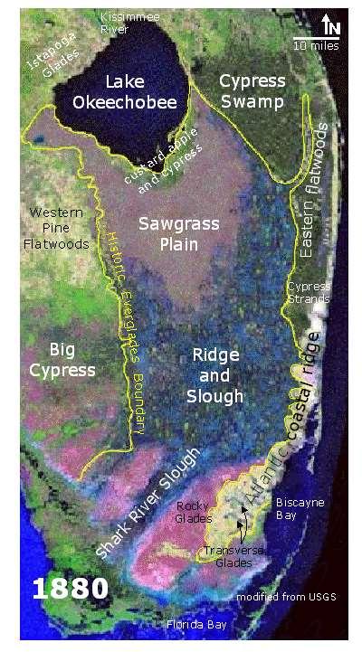
17 Answer:
18 Answer: Prior to Post-Drainage
19 Answer: Prior to Post-Drainage
20
21

22 watershed An area of land that drains to a particular point
23
24 The preserve is a self-contained rain driven watershed that flows unfettered as sheetflow to the mangrove coast
25 The preserve is a self-contained rain driven watershed that flows unfettered as sheetflow to the mangrove coast
26 The preserve is a self-contained rain driven watershed that flows unfettered as sheetflow to the mangrove coast
27 The preserve is a self-contained rain driven watershed that flows unfettered as sheetflow to the mangrove coast
28 sole input: rainfall Sky view of watershed
29 Sky view of watershed sole input: rainfall sole output: estuarine coast


30 Sky view of watershed Rain-driven swamp
31 Ground view of watershed
32 Ground view of watershed Natural flow ways called strands and sloughs flow uncontrolled by gates to estuaries in downstream ENP
33 Ground view of watershed Natural flow ways called strands and sloughs flow uncontrolled by gates to estuaries in downstream ENP
34 Ground view of watershed Natural flow ways called strands and sloughs flow uncontrolled by gates to estuaries in downstream ENP
35 Ground view of watershed Natural flow ways called strands and sloughs flow uncontrolled by gates to estuaries in downstream ENP

36 Ground view of watershed Natural flow ways called strands and sloughs flow uncontrolled by gates to estuaries in downstream ENP
37 Where did we get this story?
38 Origin myth
39 Everglades Jetport From Miami Times: Fiery Debate Over Miami Air Show in Everglades, by Jessica Weiss, 2015
40 Everglades Jetport From Miami Times: Fiery Debate Over Miami Air Show in Everglades, by Jessica Weiss, 2015
41 Everglades Jetport From Miami Times: Fiery Debate Over Miami Air Show in Everglades, by Jessica Weiss, 2015
42 Promotional Brochure
43 Promotional Brochure

44 Promotional Brochure
45 Promotional Brochure
46 Promotional Brochure
47 Promotional Brochure L-28
48 Promotional Brochure L-28
49 Promotional Brochure Miami-Collier Training and Transition Airport (TNT) L-28

50
51 Intervention by Conservationists
52 Intervention by Conservationists Joe Browder


53 Intervention by Conservationists Marjory Stoneham Douglas Joe Browder
54 Carved out as watershed that feeds downstream estuarine arm of Everglades National Park
55
56
57
58

59
60
61
62
63
64
65 Everglades Nat l Park
66 Big Cypress Swamp Everglades Nat l Park

67 Big Cypress Swamp Everglades Nat l Park
68 Big Cypress Swamp Everglades Nat l Park
69 Big Cypress Swamp Everglades Nat l Park
70 Success, right? Big Cypress Swamp Everglades Nat l Park

71 Success, right? Big Cypress Swamp Everglades Nat l Park
72 Factors that fed the myth
73 The top of the Big Cypress Swamp s historic watershed was the southern toe of the Immokalee Rise
74
75
76 Geographically separate from highly-managed Everglades to the east
77
78
79 Swamp mosaic contains smaller and less connected flow systems than the river of grass

80 Big Cypress Everglades
81 Hydrologically much less impacted that Kissimmee-Okeechobee- Everglades (KOE) ecosystem
82
83 Lies outside the USACE/SFWMD Central and Southern (C&SF) project area
84
85
86 Swamp is as close as you get to a pre-drainage condition in south Florida
87
88 Psychologically the myth worked

89 It made us feel good
90 It was expedient

91 It was expedient


92 It was what we were told
93 Who told us this story?
94


95 Audubon USGS US Congress NPS
96 Klein Report, 1970
97
98 Klein Report, 1970
99 How was the watershed determined? Klein Report, 1970
100

101

102 Davis, 1943

103 Parker, 1955

104 Parker, 1955
105
106

107 Myth of rain driven swamp is born
108
109

110 Jetport Advisory Board Report, 1971
111
112
113 547,000 acres
114 Tamiami Trail National Parkway
115 Everglades-Big Cypress Recreation Area

116 Big Cypress National Freshwater Reserve

117 Big Cypress Conservation Act, 1973
118 Big Cypress Area of Critical Concern (state law)

119 Public Law , 1974
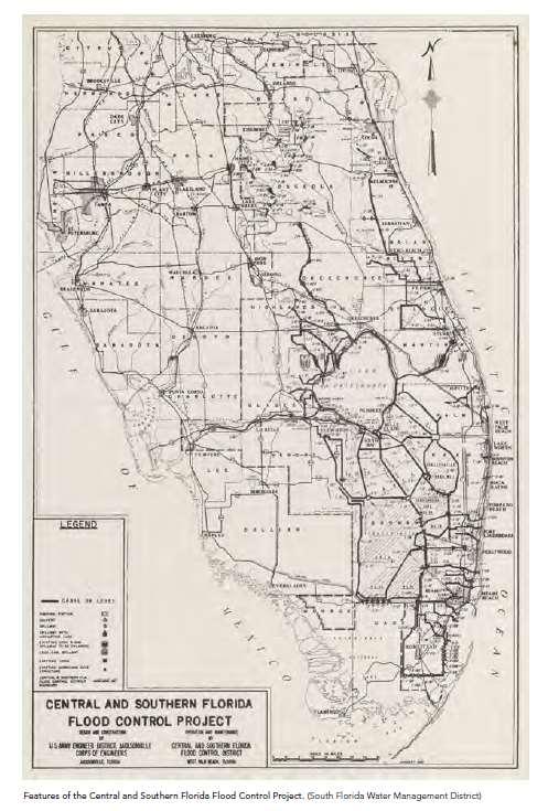
120 Big Cypress Area of Critical Concern (state law) Big Cypress National Preserve (federal law)
 Big Cypress National Preserve (federal")
121 Big Cypress Area of Critical Concern (state law) Big Cypress National Preserve (federal law)

122 Enabling Legislation
123 Legislative History of Public Law
124 More Legislative History
125 Reality
126 What actually happened
127 Construction Chronology
128 Construction Chronology
129 Construction Chronology
130 Construction Chronology
131 Construction Chronology
132 Construction Chronology
133 Construction Chronology
134 Construction Chronology
135 Construction Chronology
136 Construction Chronology
137 Construction Chronology
138 Construction Chronology
139 Construction Chronology
140 Construction Chronology
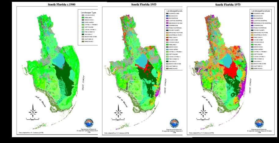
141 Construction Chronology
142 Construction Chronology
143 Construction Chronology
144 Construction Chronology

145 Construction Chronology
146 Construction Chronology
147 Construction Chronology
148 Construction Chronology 1968
149 Big Cypress inherited an altered Landscape Map View
150 Big Cypress inherited an altered Landscape Map View
151 Big Cypress inherited an altered Landscape Map View
152 Big Cypress inherited an altered Landscape Map View
153 Big Cypress inherited an altered Landscape Map View
154 Big Cypress inherited an altered Landscape Map View
155 Big Cypress inherited an altered Landscape Map View
156 Big Cypress inherited an altered Landscape Map View
157 Big Cypress inherited an altered Landscape Map View
158 Big Cypress inherited an altered Landscape Map View
159 Big Cypress inherited an altered Landscape Map View
160 Big Cypress inherited an altered Landscape Map View
161 Big Cypress inherited an altered Landscape Map View
162

163

164 Not a selfcontained rain-driven watershed
165 Truncated and canal-drained watershed
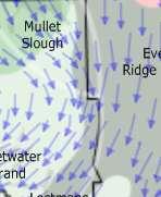
166 But that s not what s surprising!

167 Crisscrossed with canals
168 Point discharging to tide
169 Point discharging to tide

170

171 Exacerabates saltwater intrusion
172 Headwater flows have been severed
173 Headwater flows have been severed

174 West Feeder Diversions East

175 Including OK Slough
176 L28I 41 L28
177 L28I 41 L28
178 L28I 41 L28
179 L28I 41 L28
180 L28I 41 L28
181 Again, not surprising!

182 McPherson et al, 1976
183 Vegetation Map from Davis, 1940
184 Vegetation Map from Davis, 1940 Hydrographic Interpretation of 1940 map
185 Castle of pre-drainage enlightenment
186 Castle of pre-drainage enlightenment Dragon s den of self-contained watershed

187
188 The Jelly Bean
189 The Jelly Bean Big Cypress watershed Klein, 1970 watershed to ENP s estuarine arm, 1974
190 The Jelly Bean Post-drainage Big Cypress watershed Klein, 1970 Post-drainage watershed to ENP s estuarine arm, 1974

191 The Jelly Bean Post-drainage Big Cypress watershed Klein, 1970 Post-drainage watershed to ENP s estuarine arm, 1974
192 The Jelly Bean Post-drainage Big Cypress watershed Klein, 1970 Post-drainage watershed to ENP s estuarine arm, 1974
193 The Jelly Bean Post-drainage Big Cypress watershed Klein, 1970 Post-drainage watershed to ENP s estuarine arm, 1974
194 Pre-drainage? The Jelly Bean Post-drainage Big Cypress watershed Klein, 1970 Post-drainage watershed to ENP s estuarine arm, 1974
195 Pre-drainage? The Jelly Bean Post-drainage Big Cypress watershed Klein, 1970 Post-drainage watershed to ENP s estuarine arm, 1974
196
197 Kelly s assignment to WERP class:


198 Write an essay on the swamp s connection Lake O?
199 Castle of pre-drainage enlightenment Dragon s den of self-contained watershed
200 Castle of pre-drainage enlightenment Dragon s den of self-contained watershed


201 Castle of pre-drainage enlightenment Dragon s den of self-contained watershed
202
203 Loss of headwaters to north

204 Loss of headwaters to north
205 Not just Okeechobee 10 ft

206 Not just Okeechobee 10 ft
207 Ft Thomson Falls
208 Ft Thomson Falls
209 Lake Flirt
210
211

212

213 Subsidence to the East

214 Usually think of just EAA

215
216 West North East South


217 West North East South
218 West North East South
219 West North East South
220 West North East South
221 West North East South
222 And not just EAA
223 In the Everglades too

224
225
226 1-2 foot of subsidence
227 The Reality
228 Klein Report, 1970
229 Klein Report, 1970
230 Klein Report, 1970
231 +10 ft
232 +10 ft +5 ft
233 +15 ft +10 ft +5 ft
234 +15 ft +10 ft Immokalee water table +5 ft
235 +15 ft +10 ft Immokalee water table +5 ft 1-3 ft
236 +15 ft +10 ft Immokalee water table +5 ft 1-3 ft
237 +15 ft +10 ft Immokalee water table +5 ft 1-3 ft
238 +15 ft +10 ft Immokalee water table +5 ft 1-3 ft
239 +15 ft +10 ft Immokalee water table +5 ft 1-3 ft
240 +15 ft +10 ft +5 ft 1-3 ft
241 +15 ft +10 ft Immokalee water table +5 ft 1-3 ft


242 +15 ft +10 ft Immokalee water table +5 ft 1-3 ft
243
244
245
246
247
248
249
250
251

252
253 Pre-drainage Swamp Overview Pre-drainage swamp was much bigger than today s truncated watershed Pre-drainage swamp was groundwater fed by Immokalee Rise Pre-drainage swamp water Everglades fed, today it is drained into the Everglades Pre-drainage flow budget was profoundly different than today
254 Pre-drainage Swamp Overview Pre-drainage swamp was much bigger than today s truncated watershed Pre-drainage swamp was groundwater fed by Immokalee Rise Pre-drainage swamp water Everglades fed, today it is drained into the Everglades Pre-drainage flow budget was profoundly different than today
255 Pre-drainage Swamp Overview Pre-drainage swamp was much bigger than today s truncated watershed Pre-drainage swamp was groundwater fed by Immokalee Rise, not just rain Pre-drainage swamp water Everglades fed, today it is drained into the Everglades Pre-drainage flow budget was profoundly different than today
256 Pre-drainage Swamp Overview Pre-drainage swamp was much bigger than today s truncated watershed Pre-drainage swamp was groundwater fed by Immokalee Rise, not just rain Pre-drainage swamp water Everglades fed, today it is drained into the Everglades Pre-drainage flow budget was profoundly larger than today
257 Post-drainage Swamp Overview Dredging of and draining into the Caloosahatchee was first and biggest impact Pre-drainage swamp was ground-water fed, today it is ground-water drained OK Slough sadly does not flow into Fakahatchee Strand The swamp is managed as a fireshed, not as a watershed as envisioned by founders
258 Post-drainage Swamp Overview Dredging of and draining into the Caloosahatchee was first and biggest impact Pre-drainage swamp was ground-water fed, today it is ground-water drained OK Slough sadly does not flow into Fakahatchee Strand The swamp is managed as a fireshed, not as a watershed as envisioned by founders
259 Post-drainage Swamp Overview Dredging of and draining into the Caloosahatchee was first and biggest impact Pre-drainage swamp was ground-water fed, today it is ground-water drained OK Slough sadly does not flow into Fakahatchee Strand The swamp is managed as a fireshed, not as a watershed as envisioned by founders
260 Post-drainage Swamp Overview Dredging of and draining into the Caloosahatchee was first and biggest impact Pre-drainage swamp was ground-water fed, today it is ground-water drained OK Slough sadly does not flow into Fakahatchee Strand The swamp is managed as a fireshed, not as a watershed as envisioned by founders
261 Today s conservation lands are a derelict ruins of pre-drainage past
262 What do we mean by derelict ruins?
263 Think of pre-drainage swamp as a hydrologic cathedral
264
265

266
267
268
269
270
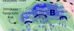
271
272
273
274
275
276
277
278
279 OK Slough Status Quo Inadequate upstream flood control Polluted water Polluted water No flow of OK Slough into Panther Refuge or Fakahatchee Canal diverts flow from natural flow paths Point discharge to coast

280 With Keystone in Place Water is cleaned in STAs and FEBs Pump provides flood control Historic headwater flows from OK Slough into Panther Refuge and Fakahatchee are reestablished Clean water is distributed into Big Cypress National Preserve Cessation of point discharge to coast

281 Closer look

282 Halfway Creek Status Quo

283 With Keystone in Place
284 Recommendations (1) Rain-driven self-contained swamp mentality has imperiled Everglades Restoration
 We can rebuild the Big Cypress Swamp ruins by strategic restoration at critical")
285 Recommendations (1) Rain-driven self-contained swamp mentality has imperiled Everglades Restoration (2) We can rebuild the Big Cypress Swamp ruins by strategic restoration at critical keystone spots
286 Status Quo isn t free
287 Status Quo isn t free

288 Status Quo isn t free $70,000,000
289 $70M = $0

290 $70M = $0 for increasing swamp s long-term natural resilience to fight drought
291 Drought vulnerable

292 Drought vulnerable
293 Drought resistant


294 Questions
Water Management and Hydrology of Northeast Shark River Slough from 1940 to 2015
 Water Management and Hydrology of Northeast Shark River Slough from 1940 to 2015 Greater Everglades Ecosystem Restoration Conference April 2015 Kevin Kotun, Hydrologist Physical Resources Branch South
9 th INTECOL Orlando, Florida June 7, 2012
 Restoration of the Everglades Saline Wetlands and Florida Bay: Responses Driven from Land and Sea David Rudnick 1, Colin Saunders 2, Carlos Coronado 2, Fred Sklar 2 Erik Stabenau 1, Vic Engel 1, Rene Price
Enhancing and Combining Complex Numerical Models of Coastal Southern Florida
 Enhancing and Combining Complex Numerical Models of Coastal Southern Florida Eric Swain, Melinda Lohmann, and Jeremy Decker U.S. Geological Survey Florida Bay and Adjacent Marine Systems Science Conference,
Estuarine Response in Northeastern Florida Bay to Major Hurricanes in 2005
 Estuarine Response in Northeastern Florida Bay to Major s in 25 By Jeff Woods and Mark Zucker s and tropical storms are critical components of the south Florida hydrologic cycle. These storms cause dramatic
Mosaic: Predictions from Alternative
 Flow and Pattern in the Ridge Slough Mosaic: Predictions from Alternative Mechanisms of Landform Development Matt Cohen, Danielle Watts, Todd Osborne University of Florida Jim Heffernan Florida International
Modeling Hydrodynamic Effects and Salinity Intrusion. Presented by Dr. Eric Swain, USGS Water Science Center, Fort Lauderdale Florida
 Modeling Hydrodynamic Effects and Salinity Intrusion Presented by Dr. Eric Swain, USGS Water Science Center, Fort Lauderdale Florida Requirements Because coastal South Florida has unique features such
Shallow Karst Aquifer System of the Lake Belt Study Area, Miami-Dade County, Florida, USA EXTENDED ABSTRACT
 Second International Conference on Saltwater Intrusion and Coastal Aquifers Monitoring, Modeling, and Management. Merida, Mexico, March 30 April 2, 2003 Shallow Karst Aquifer System of the Lake Belt Study
MIAMI-SOUTH FLORIDA National Weather Service Forecast Office
 MIAMI-SOUTH FLORIDA National Weather Service Forecast Office http://www.weather.gov/miami June 2015 South Florida Weather Summary Dry East, Wet West...Drought Remains SE Florida July 3, 2015: Depending
Sea Level Rise in Miami-Dade County Florida Implications for Management of Coastal Wetlands and the Everglades
 Sea Level Rise in Miami-Dade County Florida Implications for Management of Coastal Wetlands and the Everglades Peter W. Harlem Dr. John F. Meeder Florida International University Southeast Environmental
 Red River Flooding June 2015 Caddo and Bossier Parishes Presented by: Flood Technical Committee Where the Rain Falls Matters I-30 versus I-20 I-20 Backwater and Tributary Floods (Localized) 2016 Flood
APPENDIX D: WATER CONSERVATION AREA NO. 3, EVERGLADES NATIONAL PARK AND EVERGLADES NATIONAL PARK-SOUTH DADE CONVEYANCE SYSTEM OPERATIONAL GUIDANCE
 APPENDIX D: WATER CONSERVATION AREA NO. 3, EVERGLADES NATIONAL PARK AND EVERGLADES NATIONAL PARK-SOUTH DADE CONVEYANCE SYSTEM OPERATIONAL GUIDANCE DRAFT CSSS Operational Guidance for Water Conservation
Red River Levee Panel
 Red River Levee Panel Mississippi River Commission Monday, August 9, 2017 Red River Levees in LA & AR NONE along TX & OK Boarder Red River Levee Issues Caddo Levee Cherokee Park Authorization Bossier Levee
Flow estimations through spillways under submerged tidal conditions
 Computational Methods and Experimental Measurements XIII 137 Flow estimations through spillways under submerged tidal conditions P. D. Scarlatos 1, M. Ansar 2 & Z. Chen 2 1 Department of Civil Engineering
Technical Paper ERA #431
 Technical Paper ERA #431 (for presentation at the World Environmental & Water Resources Congress 2006 ASCE Conference in Omaha, Nebraska, May 21 to 25, 2006) Hydrologic Impact of the 2004 Hurricane Season
Project Delivery Team Meeting. December 14, Trusted Partners Delivering Value Today for a Better Tomorrow
 LOXAHATCHEE RIVER WATERSHED RESTORATION PROJECT Project Delivery Team Meeting December 14, 2016 One of the Last Old Growth Cypress Floodplains in the SE Florida Federally designated as a National Wild
Everglades National Park
 National Park Service U.S. Department of the Interior Water Budget, Climate Variability, and Predicting Salinity for Eastern Florida Bay Erik Stabenau and Kevin Kotun National Park Service Erik_Stabenau@nps.gov
Sea-Level Rise Impacts on South Florida
 Sea-Level Rise Impacts on South Florida Keren Prize Bolter, PhD Science Director, Coastal Risk Consulting. LLC 5/3/16 FAQ list What is happening? What impacts are we already seeing? Just how vulnerable
Marl Prairie vegetation response to 20th century land use and its implications for management in the Everglades
 Marl Prairie vegetation response to 20th century land use and its implications for management in the Everglades C. Bernhardt, D. Willard, B. Landacre US Geological Survey Reston, VA USA U.S. Department
The Role of the Mangrove Ecotone Region in Regulating Nutrient Cycling and Wetland Productivity in South Florida
 The Role of the Mangrove Ecotone Region in Regulating Nutrient Cycling and Wetland Productivity in South Florida Victor H. Rivera-Monroy, Stephen E. Davis III, Robert R. Twilley, Daniel L. Childers, Marc
E XTREME D ROUGHT An oppressive, long-term
 E XTREME D ROUGHT 2006-2008 An oppressive, long-term drought lasting from late March of 2006 until late August of 2008 impacted the entire state of Florida, with costly consequences in residential water
Laboratory Exercise #3 The Hydrologic Cycle and Running Water Processes
 Laboratory Exercise #3 The Hydrologic Cycle and Running Water Processes page - 1 Section A - The Hydrologic Cycle Figure 1 illustrates the hydrologic cycle which quantifies how water is cycled throughout
LOCATED IN INDIAN RIVER COUNTY PREPARED FOR S.J.R.W.M.D. AND F.W.C.D. DECEMBER, 2003 Updated 2007 Updated May 2014 PREPARED BY
 FELLSMERE WATER CONTROL DISTRICT EAST MASTER DRAINAGE PLAN AND STORMWATER HYDROLOGIC ANALYSIS OF THE GRAVITY DRAINAGE SYSTEM LOCATED BETWEEN THE EAST BOUNDARY, LATERAL U, THE MAIN CANAL, AND DITCH 24 LOCATED
US Army Corps of Engineers BUILDING STRONG
 Greater New Orleans Hurricane and Storm Damage Risk Reduction System Robert Rowlette Senior Senior Program Manager Task Force Hope U.S. Army Corps of Engineers April 19, 2012 US Army Corps of Engineers
Sediment and nutrient transport and storage along the urban stream corridor
 Sediment and nutrient transport and storage along the urban stream corridor Greg Noe, Cliff Hupp, Ed Schenk, Jackie Batson, Nancy Rybicki, Allen Gellis What is the role of floodplains everywhere? Noe 2013,
SYSTEM WIDE WATER RESOURCES PROGRAM UNIFYING TECHNOLOGIES GEOSPATIAL APPLICATIONS (GIS IN SWWRP)
") SYSTEM WIDE WATER RESOURCES PROGRAM UNIFYING TECHNOLOGIES GEOSPATIAL APPLICATIONS (GIS IN SWWRP) 3 August 2005 2005 Tri-Service Infrastructure Systems Conference Re-Energizing Engineering Excellence The
SYSTEM WIDE WATER RESOURCES PROGRAM UNIFYING TECHNOLOGIES GEOSPATIAL APPLICATIONS (GIS IN SWWRP) 3 August 2005 2005 Tri-Service Infrastructure Systems Conference Re-Energizing Engineering Excellence The
Learning Objectives: I can identify and interpret river flows and directions.
 Learning Objectives: I can identify and interpret river flows and directions. Bellringer Review: Check for Understanding Questions: 1 2 What Are The Key Parts Of A River s Anatomy? In your data notebooks
Field Observations and One-Dimensional Flow Modeling of Summit Creek in Mack Park, Smithfield, Utah
 Intermountain Center for River Rehabilitation and Restoration, Utah State University 31 July 2018 Field Observations and One-Dimensional Flow Modeling of Summit Creek in Mack Park, Smithfield, Utah I.
APPENDIX D QUESTIONS/ACTIVITIES FOR TEACHERS AND STUDENTS
 APPENDIX D QUESTIONS/ACTIVITIES FOR TEACHERS AND STUDENTS The questions below are intended for teachers as they educate K-12 Geography students using the Japanese American relocation centers as their focal
Ecosystem History of Florida Bay and the Southern Estuaries Five Year Update. G. Lynn Wingard (USGS)
") Ecosystem History of Florida Bay and the Southern Estuaries Five Year Update G. Lynn Wingard (USGS) Progress since 2003 Florida Bay Science Conference Expansion of Ecosystem History Research into surrounding
Ecosystem History of Florida Bay and the Southern Estuaries Five Year Update G. Lynn Wingard (USGS) Progress since 2003 Florida Bay Science Conference Expansion of Ecosystem History Research into surrounding
WELCOME Lake Wabukayne OPEN HOUSE
 WELCOME Lake Wabukayne Sediment Removal Project OPEN HOUSE We are here to: Update you, the community, on recent developments and activities at Lake Wabukayne Present the preferred alternative and receive
South Florida Storm Surge
 South Florida Storm Surge Highest storm tide Everglades City/Chokoloskee in area closest to landfall Nevertheless, storm tide as high as 6 feet along Biscayne Bay about 90 miles from eye of Irma! Closer
Earth Wind & Fire. Game Changing Restoration Options in the Texas Chenier Plain
 Earth Wind & Fire Game Changing Restoration Options in the Texas Chenier Plain EARTH: The Chenier Plain is a 5 million acre coastal region in Southwest Louisiana and Southeast Texas providing landscape
GRAPEVINE LAKE MODELING & WATERSHED CHARACTERISTICS
 GRAPEVINE LAKE MODELING & WATERSHED CHARACTERISTICS Photo Credit: Lake Grapevine Boat Ramps Nash Mock GIS in Water Resources Fall 2016 Table of Contents Figures and Tables... 2 Introduction... 3 Objectives...
How Do Human Impacts and Geomorphological Responses Vary with Spatial Scale in the Streams and Rivers of the Illinois Basin?
 How Do Human Impacts and Geomorphological Responses Vary with Spatial Scale in the Streams and Rivers of the Illinois Basin? Bruce Rhoads Department of Geography University of Illinois at Urbana-Champaign
Illinois State Water Survey Division
 Illinois State Water Survey Division SURFACE WATER SECTION SWS Miscellaneous Publication 108 SEDIMENT YIELD AND ACCUMULATION IN THE LOWER CACHE RIVER by Misganaw Demissie Champaign, Illinois June 1989
Ecological Patterns and Processes in Ghost Tree Islands of the Everglades
 Ecological Patterns and Processes in Ghost Tree Islands of the Everglades Sharon M. L. Ewe 1, Binhe Gu 2, Jennifer Vega 1 and Kristin Vaughan 1 1 Ecology and Environment Inc., 12300 South Shore Blvd, Wellington,
IS THERE ENOUGH SEDIMENT? Presentation at the State of the Estuary Conference San Francisco, CA, October 9-10, By Philip B.
 IS THERE ENOUGH SEDIMENT? Presentation at the State of the Estuary Conference San Francisco, CA, October 9-10, 2001 By Philip B. Williams 1. INTRO I AM TEMPTED TO MAKE THIS THE SHORTEST TALK OF THE CONFERENCE:
Restored oyster reefs enhance estuarine ecosystem services by altering nearshore salinity
 Restored oyster reefs enhance estuarine ecosystem services by altering nearshore salinity Photo: UF/IFAS David Kaplan, Maitane Olabarrieta, Peter Frederick, and Arnoldo Valle-Levinson Globally: Most Threatened
RAINFALL AVERAGES AND SELECTED EXTREMES FOR CENTRAL AND SOUTH FLORIDA. Thomas K. MacVicar
 TECHNICAL PUBLICATION #83-2 March 1983 RAINFALL AVERAGES AND SELECTED EXTREMES FOR CENTRAL AND SOUTH FLORIDA by Thomas K. MacVicar "This public document was promulgated at an annual cost of $136.74, or
Biodiversity Blueprint Overview
 Biodiversity Blueprint Overview Climate Variability Climate projections for the Glenelg Hopkins Regions suggest that the weather will be hotter and drier in the coming years which will impact on land use,
Application #: TEXT
 TOWN OF FORT MYERS BEACH 2008 PROPOSED COMPREHENSIVE PLAN AMENDMENTS Application #: 2008-13-TEXT Description: Modify the Coastal Management and Future Land Use Elements to reflect the state s new definition
Frank Marshall CLF. Lynn Wingard, USGS Patrick Pitts, USFWS. Evelyn Gaiser, FIU Ania Wachnicka, FIU
 Pre-drainage Everglades Hydrology and Florida Bay Salinity Based on Paleoecology and Statistical Models Florida Bay and Adjacent Marine Systems Science Conference 2008 Frank Marshall CLF Lynn Wingard,
SEAGRASS COVERAGE TRENDS IN THE INDIAN RIVER LAGOON SYSTEM
 Biological Sciences SEAGRASS COVERAGE TRENDS IN THE INDIAN RIVER LAGOON SYSTEM R. W. VIRNSTEIN *,J.S.STEWARD, AND L. J. MORRIS St. Johns River Water Management District, Palatka, FL 32178 ABSTRACT: We
Chapter 5 CALIBRATION AND VERIFICATION
 Chapter 5 CALIBRATION AND VERIFICATION This chapter contains the calibration procedure and data used for the LSC existing conditions model. The goal of the calibration effort was to develop a hydraulic
Connectivity Between the Mangrove Ecotone Region and Florida Bay: Current Understanding in Carbon and Nutrient Fluxes
 Connectivity Between the Mangrove Ecotone Region and Florida Bay: Current Understanding in Carbon and Nutrient Fluxes Victor H. Rivera-Monroy, Stephen E. Davis III, Robert R. Twilley, Daniel L. Childers,
Planning for the Future of Humboldt Bay: Sea Level Rise, Sediment Management, Sand Spits and Salt Marshes. Joel Gerwein
 Planning for the Future of Humboldt Bay: Sea Level Rise, Sediment Management, Sand Spits and Salt Marshes Joel Gerwein Introduction to Humboldt Bay Setting Economy, community, and environment Sediment
AlL^Ol^^ A DISSERTATION PRESENTED TO THE GRADUATE SCHOOL OF THE UNIVERSITY OF FLORIDA IN PARTIAL FULFILLMENT OF THE REQUIREMENTS FOR THE DEGREE OF
 AlL^Ol^^ SPATTAL AND TEMPORAL DYNAMICS IN THE EVERGLADES ECOSYSTEM WITH IMPLICATIONS FOR WATER DEUVERIES TO EVERGLADES NATIONAL PARK By LANCE H. GUNDERSON A DISSERTATION PRESENTED TO THE GRADUATE SCHOOL
Ground Water Control of Tree Island Origin, Genesis and Destruction. By John F. Meeder and Peter W. Harlem SERC,FIU
 Ground Water Control of Tree Island Origin, Genesis and Destruction By John F. Meeder and Peter W. Harlem SERC,FIU Functional Definition Our functional definition of a Tree Island is; an isolated scrub
Section 5. Low-Gradient Streams. What Do You See? Think About It. Investigate. Learning Outcomes
 Chapter 4 Surface Processes Section 5 Low-Gradient Streams What Do You See? Learning Outcomes In this section, you will Use models and real-time streamflow data to understand the characteristics of lowgradient
L-31N Seepage Management Field Test
 Miami-Dade Limestone Products Association 13292 N.W. 118 th Avenue Miami, FL 33178 L-31N Seepage Management Field Test The Performance of a Partially Penetrating Seepage Barrier along the L-31N Canal July
Statement of Impact and Objectives. Watershed Impacts. Watershed. Floodplain. Tumblin Creek Floodplain:
 Tumblin Creek Floodplain: Impacts Assessment and Conceptual Restoration Plan Casey A. Schmidt Statement of Impact and Objectives Urbanization has increased stormflow rate and volume and increased sediment,
COLUSA BASIN WATERSHED ASSESSMENT. Final. Prepared by: H. T. Harvey & Associates. In Collaboration With:
 COLUSA BASIN WATERSHED ASSESSMENT Prepared by: In Collaboration With: G. Mathias Kondolf Geomorph Blankinship & Associates Prepared for: Colusa County Resource Conservation District 100 Sunrise Boulevard,
Mapping the River as it Reconnects with Its Delta: Field Studies in Big Mar and Bohemia
 Mapping the River as it Reconnects with Its Delta: Field Studies in Big Mar and Bohemia Ezra Boyd, John Lopez, Andy Baker, Theryn Henkel Lake Pontchartrain Basin Foundation Coastal Sustainability Program
The Yellow River Initiative: The Birth of a System Approach to Challenges Facing the Everglades of the North
 The Yellow River Initiative: The Birth of a System Approach to Challenges Facing the Everglades of the North Robert Barr and Siavash Beik 2016 INAFSM Annual Conference Belterra Conference Center, Indiana
Population Dynamics and Conservation of Snail Kites in Florida: The Importance of Spatial and Temporal Scale
 Population Dynamics and Conservation of Snail Kites in Florida: The Importance of Spatial and Temporal Scale ROBERT E. BENNETTS' AND WILEY M. KITCHENS 2 'Department of Wildlife Ecology and Conservation,
Background and Purpose of Meeting. River Towers Meeting. Flood Risk Management Study Alternatives Overview
 1 and Purpose of Meeting River Towers Meeting Flood Risk Management Study Alternatives Overview September 23, 2014 There is no "proposed" flood risk management solution for this area at this time Fairfax
REDWOOD VALLEY SUBAREA
 Independent Science Review Panel Conceptual Model of Watershed Hydrology, Surface Water and Groundwater Interactions and Stream Ecology for the Russian River Watershed Appendices A-1 APPENDIX A A-2 REDWOOD
Freshwater-Tidal Gradients: Eco-geomorphology Linkages to Watershed-Estuarine Dynamics
 Freshwater-Tidal Gradients: Eco-geomorphology Linkages to Watershed-Estuarine Dynamics Kathy Boomer (The Nature Conservancy) Scott Ensign (Stroud Research) Greg Noe (USGS) Concluding Speculations: It s
Changes in Texas Ecoregions
 Comment On Lesson Changes in Texas Ecoregions The state of Texas can be divided into 10 distinct areas based on unique combinations of vegetation, topography, landforms, wildlife, soil, rock, climate,
Issues within the Sub-Watershed: Thief River
 Issues within the Sub-Watershed: Thief River What are the existing conditions, related potential problems and solution alternatives? Issues related to: FLOOD DAMAGE Flooding Agland & farmstead flooding,
Lower Tuolumne River Accretion (La Grange to Modesto) Estimated daily flows ( ) for the Operations Model Don Pedro Project Relicensing
 Estimated daily flows ( ) for the Operations Model Don Pedro Project Relicensing") Lower Tuolumne River Accretion (La Grange to Modesto) Estimated daily flows (1970-2010) for the Operations Model Don Pedro Project Relicensing 1.0 Objective Using available data, develop a daily time series
Lower Tuolumne River Accretion (La Grange to Modesto) Estimated daily flows (1970-2010) for the Operations Model Don Pedro Project Relicensing 1.0 Objective Using available data, develop a daily time series
Natural Disasters. in Florida. Severe Thunderstorms
 Natural Disasters in Florida SC.6.E.7.7 Investigate how natural disasters have affected human life in Florida. Severe Thunderstorms While the typical afternoon thunderstorm in Florida may not appear to
ATLANTIC INTRACOASTAL WATERWAY NORFOLK DISTRICT. Joel F. Scussel, Operations Support Section Dismal Swamp Canal July 27, 2017
 ATLANTIC INTRACOASTAL WATERWAY 1 255 255 255 237 237 237 0 0 0 217 217 217 163 163 163 200 200 200 131 132 122 239 65 53 80 119 27 NORFOLK DISTRICT 110 135 120 252 174.59 112 92 56 62 102 130 102 56 48
ARTICLE IN PRESS. Received 9 February 2006; received in revised form 5 June 2007; accepted 7 June 2007
 RSE-06912; No of Pages 16 ARTICLE IN PRESS + MODEL Remote Sensing of Environment xx (2007) xxx xxx www.elsevier.com/locate/rse Space-based detection of wetlands' surface water level changes from L-band
Introduction Fluvial Processes in Small Southeastern Watersheds
 Introduction Fluvial Processes in Small Southeastern Watersheds L. Allan James Scott A. Lecce Lisa Davis Southeastern Geographer, Volume 50, Number 4, Winter 2010, pp. 393-396 (Article) Published by The
3.11 Floodplains Existing Conditions
 Other stormwater control practices may be needed to mitigate water quality impacts. In addition to detention facilities, other practices such as vegetated basins/buffers, infiltration basins, and bioswales
Types of Wetlands. Tidal Systems
 Types of Wetlands Tidal Systems 1 COASTAL WETLAND ECOSYSTEMS Tidal Salt Marshes Tidal Freshwater Marshes Mangrove Wetlands 2 Tidal Estuarine Wetland 3 Definition and Formation of Estuaries Estuary: : partially
EAGLES NEST AND PIASA ISLANDS
 EAGLES NEST AND PIASA ISLANDS HABITAT REHABILITATION AND ENHANCEMENT PROJECT MADISON AND JERSEY COUNTIES, ILLINOIS ENVIRONMENTAL MANAGEMENT PROGRAM ST. LOUIS DISTRICT FACT SHEET I. LOCATION The proposed
Subtidal permanently flooded with tidal water. Irregularly exposed surface exposed by tides less often than daily
 Types of Wetlands Tidal Systems COASTAL WETLAND ECOSYSTEMS Tidal Salt Marshes Tidal Freshwater Marshes Mangrove Wetlands Tidal Estuarine Wetland 1 Definition and Formation of Estuaries u Estuary : partially
Doug Kluck NOAA Kansas City, MO National Center for Environmental Information (NCEI) National Integrated Drought Information System (NIDIS)
 National Integrated Drought Information System (NIDIS)") National Integrated Drought Information System (NIDIS) for the Missouri River Basin Drought Early Warning Information System (DEWS) & Runoff Trends in the Missouri Basin & Latest Flood Outlook Doug Kluck
National Integrated Drought Information System (NIDIS) for the Missouri River Basin Drought Early Warning Information System (DEWS) & Runoff Trends in the Missouri Basin & Latest Flood Outlook Doug Kluck
Conceptual Model of Stream Flow Processes for the Russian River Watershed. Chris Farrar
 Conceptual Model of Stream Flow Processes for the Russian River Watershed Chris Farrar Several features of creeks affect the interactions between surface and groundwater. This conceptual model uses the
Hydrologic Analysis for Ecosystem Restoration
 Hydrologic Analysis for Ecosystem Restoration Davis, California Objectives: To provide participants with: 1) an understanding of the issues in restoration studies; 2) an overview of Corps policies and
Background on the March 13-14, 2007 Flooding in Browns Valley (Traverse County), Minnesota
, Minnesota") Background on the March 13-14, 2007 Flooding in Browns Valley (Traverse County), Minnesota Report to the Minnesota Governor s Office Prepared by: Minnesota Department of Natural Resources Waters Division
Background on the March 13-14, 2007 Flooding in Browns Valley (Traverse County), Minnesota Report to the Minnesota Governor s Office Prepared by: Minnesota Department of Natural Resources Waters Division
December 16, Mr. Lee Hughes Southwest Florida Water Management District Tampa Service Office 7601 Highway 301 North Tampa, FL 33637
 December 16, 2015 Mr. Lee Hughes Southwest Florida Water Management District Tampa Service Office 7601 Highway 301 North Tampa, FL 33637 RE: Response to SWFWMD Supplemental Information Request Dear Mr.
CLIMATE READY BOSTON. Climate Projections Consensus ADAPTED FROM THE BOSTON RESEARCH ADVISORY GROUP REPORT MAY 2016
 CLIMATE READY BOSTON Sasaki Steering Committee Meeting, March 28 nd, 2016 Climate Projections Consensus ADAPTED FROM THE BOSTON RESEARCH ADVISORY GROUP REPORT MAY 2016 WHAT S IN STORE FOR BOSTON S CLIMATE?
Regional Sediment Management
 Regional Sediment Management Linda S. Lillycrop Program Manager Coastal Engineer US Army Engineer Research and Development Center Coastal and Hydraulics Laboratory Q AVG Coastal Resilience: The Environmental,
THE TRINITY RIVER VISION/ GATEWAY PARK / PANTHER ISLAND
 Quarterly Project Status Report May 2018 THE TRINITY RIVER VISION/ GATEWAY PARK / PANTHER ISLAND Flood Control Project Update Construction of North Main Street Bridge by TxDOT s bridge contractor, Texas
9. PROBABLE MAXIMUM PRECIPITATION AND PROBABLE MAXIMUM FLOOD
 9. PROBABLE MAXIMUM PRECIPITATION AND PROBABLE MAXIMUM FLOOD 9.1. Introduction Due to the size of Watana Dam and the economic importance of the Project to the Railbelt, the Probable Maximum Flood (PMF)
3/3/2013. The hydro cycle water returns from the sea. All "toilet to tap." Introduction to Environmental Geology, 5e
 Introduction to Environmental Geology, 5e Running Water: summary in haiku form Edward A. Keller Chapter 9 Rivers and Flooding Lecture Presentation prepared by X. Mara Chen, Salisbury University The hydro
Monitoring seasonal variability of the soil profile with paired deep and shallow Surface Elevation Tables (SET) in the southwest coastal Everglades.
 in the southwest coastal Everglades.") Monitoring seasonal variability of the soil profile with paired deep and shallow Surface Elevation Tables (SET) in the southwest coastal Everglades. Karen M. Balentine Advisor: Dr. Larry Rex Ellis University
Monitoring seasonal variability of the soil profile with paired deep and shallow Surface Elevation Tables (SET) in the southwest coastal Everglades. Karen M. Balentine Advisor: Dr. Larry Rex Ellis University
Influence of the Major Drainages to the Mississippi River and Implications for System Level Management
 Influence of the Major Drainages to the Mississippi River and Implications for System Level Management Brian M. Vosburg Geologist Louisiana Coastal Protection and Restoration Authority brian.vosburg@la.gov
THE TRINITY RIVER VISION/ GATEWAY PARK / PANTHER ISLAND Flood Control Project Update
 Quarterly Project Status Report September 2018 THE TRINITY RIVER VISION/ GATEWAY PARK / PANTHER ISLAND Flood Control Project Update TxDot s contractor has nearly completed the superstructure false work
Sedimentation in the Nile River
 Advanced Training Workshop on Reservoir Sedimentation Sedimentation in the Nile River Prof. Dr. Abdalla Abdelsalam Ahmed 10-16 Oct. 2007, IRTCES, Beijing, China CWR,Sudan 1 Water is essential for mankind
The Refugia Concept: Using Watershed Analysis to Prioritize Salmonid Habitat for Conservation and Restoration
 The Refugia Concept: Using Watershed Analysis to Prioritize Salmonid Habitat for Conservation and Restoration Christopher May Battelle & UW Cumulative Impacts of Urbanization Landscape Alterations Loss
Optimal Design of Sediment Diversions for Delta Restoration: lessons learned from examples
 Optimal Design of Sediment Diversions for Delta Restoration: lessons learned from examples Samuel Bentley 1, Angelina Freeman 2, Clinton S. Willson 1, Liviu Giosan 3, Jaye Cable 4 1 LSU 2 EDF 3 WHOI 4
Appendix D. Sediment Texture and Other Soil Data
 5 6 7 8 Appendix D. Sediment Texture and Other Soil Data This appendix describes the sediment texture of the aquifer system in the Restoration Area. The contents of this appendix describe the: Importance
May 7, Roger Leventhal, P.E. Marin County Public Works Laurel Collins Watershed Sciences
 May 7, 2013 Roger Leventhal, P.E. Marin County Public Works Laurel Collins Watershed Sciences Background Funded in 2009 under EPA 2100 Grant for $30k and managed by SFEP Project Goals: Update original
Landslide & Coastal Erosion Risk Reduction at Oregon s Water/Wastewater Networks
 Landslide & Coastal Erosion Risk Reduction at Oregon s Water/Wastewater Networks Laura Gabel, RG (with Bill Burns, RG & Jonathan Allan, Ph. D) Oregon Department of Geology and Mineral Industries (541)
USING GIS TO MODEL AND ANALYZE HISTORICAL FLOODING OF THE GUADALUPE RIVER NEAR NEW BRAUNFELS, TEXAS
 USING GIS TO MODEL AND ANALYZE HISTORICAL FLOODING OF THE GUADALUPE RIVER NEAR NEW BRAUNFELS, TEXAS ASHLEY EVANS While the state of Texas is well-known for flooding, the Guadalupe River Basin is one of
April 9, Phosphate Mining and Reclamation Overview
 April 9, 2012 Phosphate Mining and Reclamation Overview Business & Mission Mosaic produces the majority of the phosphate used by American farmers Employs approximately 7,000 people worldwide, 3,000 in
Betsy Stevenson and Allison Mohrs (Skagit County Planning and Development Services) Jenny Baker, The Nature Conservancy
 Jenny Baker, The Nature Conservancy") TC Fisher Slough Final Design and Permitting Subject: Well Review Memorandum To: From: Betsy Stevenson and Allison Mohrs (Skagit County Planning and Development Services) Jenny Baker, The ature Conservancy
TC Fisher Slough Final Design and Permitting Subject: Well Review Memorandum To: From: Betsy Stevenson and Allison Mohrs (Skagit County Planning and Development Services) Jenny Baker, The ature Conservancy
PENNSYLVANIA DEPARTMENT OF TRANSPORTATION ENGINEERING DISTRICT 3-0
 PENNSYLVANIA DEPARTMENT OF TRANSPORTATION ENGINEERING DISTRICT 3-0 LYCOMING COUNTY S.R.15, SECTION C41 FINAL HYDROLOGIC AND HYDRAULIC REPORT STEAM VALLEY RUN STREAM RELOCATION DATE: June, 2006 REVISED:
Tropical Update. 5 PM EDT Sunday, September 10, 2017 Hurricane Irma, Hurricane Jose, Tropical Wave (60%)
") Tropical Update 5 PM EDT Sunday, September 10, 2017 Hurricane Irma, Hurricane Jose, Tropical Wave (60%) This update is intended for government and emergency response officials, and is provided for informational
Tropical Update 5 PM EDT Sunday, September 10, 2017 Hurricane Irma, Hurricane Jose, Tropical Wave (60%) This update is intended for government and emergency response officials, and is provided for informational
Mississippi River and Tributaries Project Mississippi River Geomorphology and Potamology Program
 Mississippi River and Tributaries Project Mississippi River Geomorphology and Potamology Program Barb Kleiss, Mississippi Valley Division Freddie Pinkard, Vicksburg District June, 2016 Program Objectives
Tropical Storm Colin Briefing Last Briefing on this System
 Tropical Storm Colin Briefing Last Briefing on this System NWS WFO Jacksonville, Florida Tuesday, June 07, 2016 6:00 a.m. EDT Tropical Storm Colin s Impacts SE Georgia & North Florida Local Watches & Warnings:
Hurricane Wilma Post Storm Data Acquisition Estimated Peak Wind Analysis and Storm Tide Data. December 27, 2005
 Hurricane Wilma Post Storm Data Acquisition Estimated Peak Wind Analysis and Storm Tide Data December 27, 2005 Hurricane Wilma was the sixth major hurricane of the record-breaking 2005 Atlantic hurricane
FUTURE MEANDER BEND MIGRATION AND FLOODPLAIN DEVELOPMENT PATTERNS NEAR RIVER MILES 200 TO 191 OF THE SACRAMENTO RIVER PHASE III REPORT
 FUTURE MEANDER BEND MIGRATION AND FLOODPLAIN DEVELOPMENT PATTERNS NEAR RIVER MILES 200 TO 191 OF THE SACRAMENTO RIVER PHASE III REPORT Eric W. Larsen REPORT FOR DUCKS UNLIMITED March 31, 2006-1 - Contents
Camilla Correll, PE and Meghan Funke PhD. Advisory Work Group September 2017 Water Conversations Summary
 Project Name Cannon River One Watershed, One Plan Date 10/05/2017 To / Contact info Cc / Contact info From / Contact info Regarding Planning Work Group BWSR Advisory Staff Camilla Correll, PE and Meghan
CITY OF TUSCALOOSA ORGANIZATION OF 2015 FMP FLOODPLAIN MANAGEMENT PLAN
 CITY OF TUSCALOOSA FLOODPLAIN MANAGEMENT PLAN FMPC Meeting #2 July 8, 2015 ORGANIZATION OF 2015 FMP 2015 Floodplain Management Plan Structure Chapter 1 Introduction Chapter 2 Community Profile Chapter
Appendix B - Alabama-Coosa-Tallapoosa (ACT) Basin
 Basin") Appendix B - Alabama-Coosa-Tallapoosa (ACT) Basin 1 ACT BASIN 1.1 DESCRIPTION OF BASIN The headwater streams of the Alabama-Coosa-Tallapoosa (ACT) System rise in the Blue Ridge Mountains of Georgia and
Appendix B - Alabama-Coosa-Tallapoosa (ACT) Basin 1 ACT BASIN 1.1 DESCRIPTION OF BASIN The headwater streams of the Alabama-Coosa-Tallapoosa (ACT) System rise in the Blue Ridge Mountains of Georgia and