Strategies for dealing with sea level rise
|
|
|
- Tyler Kennedy
- 5 years ago
- Views:
Transcription

1 Nordic Conference on Climate Change Adaptation Strategies for dealing with sea level rise Hugo Kind Strategic Coordinator Climate Adaptation Preparedness and societal development Urban and community planning

2 Heavy rain CITY OF STAVANGER

3 Heavy wind CITY OF STAVANGER


4 ..heavy wind.. CITY OF STAVANGER

5 CITY OF STAVANGER

6 «Worst case»..complexed scenario Exstreme percipitation - wind sea leval rise storm surge - waves - cold CITY OF STAVANGER

7 Stavanger, oktober 2100? CITY OF STAVANGER

8 Sea leval rise 2100? CITY OF STAVANGER

9 STAVANGER KOMMUNE


10 Stavanger - Norway's densest populated municipality 71,2 km innbyggere Founded in 1125 Ups- and downs Sailing ship industry Canning industry Shipping Oil and gas STAVANGER KOMMUNE This project has received funding from the European Union s Horizon 2020 research and innovation programme under Grant Agreement No Topic: SCC : Smart Cities and Communities Nature based solutions
 STAVANGER KOMMUNE This project has received funding from the European Union s Horizon 2020 research and innovation programme under Grant Agreement No.")
11 An overview on the city landscape Short distance to the sea Several lakes Few big areas of green, but a well established green structure Few big waterways Densely populated living areas The largest wooden town in Europe (?) STAVANGER KOMMUNE This project has received funding from the European Union s Horizon 2020 research and innovation programme under Grant Agreement No Topic: SCC : Smart Cities and Communities Nature based solutions


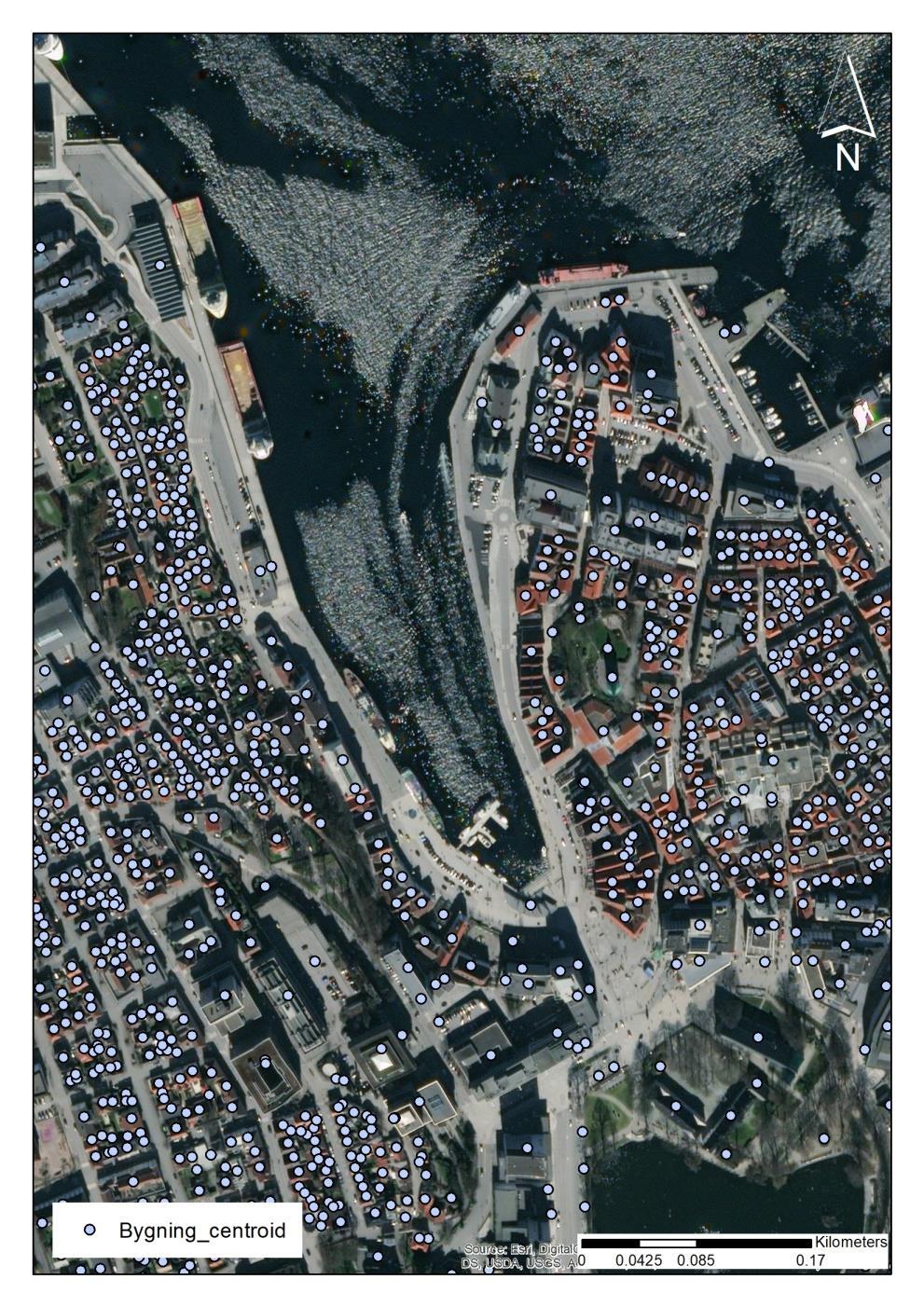
12 The city center STAVANGER KOMMUNE

13
14 Challenges STAVANGER KOMMUNE

15 Sea level rise Western Norway gets the most sea leval rise in Norway due to less land rise The predictions are a 79 cm rise by 2100 In the master plan for Stavanger city center: areas lower than 3 meters above sea level can be flood exposed by combination of future sea rise and storm flood and waves Thematic map «Flood measures», Master plan for Stavanger city center STAVANGER KOMMUNE This project has received funding from the European Union s Horizon 2020 research and innovation programme under Grant Agreement No Topic: SCC : Smart Cities and Communities Nature based solutions


16 Approach in dealing with climate change and adaptation NORADAPT Community Adaptation & Vulnerability in Norway Startdato: Sluttdato: Cities of the Future Municipality master plan Social element Land-use element Municipality sectorplan Climate & environment CITY OF STAVANGER
17 Adapting to a changing climate Participation in research projects Help to make the municipality able to cope with a future changed climate Specific risk and vulnerability assessments of climate change Develop climate change adaptation plan Protecting a good level of sociatal safety in a future changed climate The need today is to lay down rules and guidelines to ensure: Good and safe surface water management and densification of quality Safe development in: Landslide and flood-prone areas Areas with risk of sea level rise CITY OF STAVANGER

18 Møte om Nytte-kostnadsanalyse av konsekvenser ved oversvømmelse fra hav og kraftig nedbør Stavanger Mette Dalsgaard Arne Bernt Hasling APRIL 2017 NKA KLIMATILPASNING TROMSØ OG STAVANGER
19 Overall results cost / benefit analyses IPCC 8.5 scenario Storm Surge level 200 cm Flood protection is calculated by use of wall / masonry to protect 80% Nettonåtidsverdi (mill. NOK) Skadekostnader uten tiltak Skadekostnader med tiltak Afværget skade Tiltakskostnader 910 Nettogevinst Omkostninger ved skader og tiltak APRIL 2017 NKA KLIMATILPASNING TROMSØ OG STAVANGER
20 Anywhere Horizon 2020 EnhANcing emergency management and response to extreme WeatHER and climate Events ( ) CITY OF STAVANGER
21 ANYWHERE & Ferrara Storm Surge Modelling City of Stavanger have long been concerned about to developing better data and knowledge base related to challenges towards the sea, such as extreme weather, storm and wave impacts There are no good enough supervisors to handle, for example, wave challenges We believe that Anywhere's project is best served to get as good input data as possible, to achieve the project's goals, and not least solve the challenge of Stavanger CITY OF STAVANGER


22 RISK BASED DECISION SUPPORT Jan Håvard Skjetne Stavanger,
23 Why Local decision makers need more support to use weather forecasts The forecasts and prognoses are not targeted enough for local conditions and knowledge
24 Requirements for the Risk Analyser User requirement: Simple to use and use existing local knowledge Technical requirements: Easy to integrate Low cost Resilient & fault tolerant 24
25 Decision models Based on the risk and vulnerability analyses made by municipalities Assets Hazards Consequences Actions 26

26 Asset: A Hazard: Flood Rain: Heavy Wind: Svak vind Snow melting: Minimal Water level: Increasing Number of people: Risk for life and health: Big Probability for flooding: High Risk for houses and camping: Big Actions: Flood preventing measures and evacuation

27 The INDRA model for the evaluation of the impacts of storms: example of the Emilia-Romagna region in Italy Clara Armaroli, Enrico Duo Consorzio Futuro in Ricerca


28 RESILIENCE-INCREASING STRATEGIES FOR COASTS TOOLKIT - EU FP7 (GA )
 Armaroli,")
29 CRAF 1 Identification of sensitive areas (Hotspots) at the regional scale Ranking of hotspots on the basis CRAF 2 of the storm impact assessment (where to act first) Armaroli, Duo CFR


30 Application of the INDRA model to the city of Stavanger, Norway Armaroli, Duo - CFR


31 Armaroli, Duo - CFR Vidar 12. Januar 2017, 10:44 a.m.

32 Hazard map inundation simulation, Flood Depth Armaroli, Duo - CFR
33 Hazard map inundation simulation, Flood Depth Armaroli, Duo - CFR
34 Hazard map inundation simulation, Velocities Armaroli, Duo - CFR

35 Location of buildings Elevations

")
36 Transport system Local (hotspot) Regional
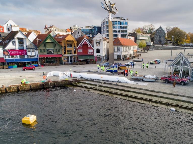


37 Flood protection Vågen STAVANGER KOMMUNE

38

39 STAVANGER KOMMUNE

40 STAVANGER KOMMUNE

41 STAVANGER KOMMUNE

42 STAVANGER KOMMUNE

43 STAVANGER KOMMUNE


44 STORM SURGE HAZARD IN ANYWHERE REGIONAL-LOCAL SCALE (PILOT SITE: STAVANGER) 22th May 2018
.")
45 1. Introduction The storm surge phenomenon produces an anomalous rise in water level. It is forced by wind-driven water circulation towards or away from the coast and by atmospheric pressure-driven changes of the water level; i.e. the inverse barometric effect (WMO 2011). French Coast Xynthia storm Feb-2010 Flooding of coastal areas UK east coast Xaver storm Dec-2013 Coastal erosion
46 2. Work flow WORK FLOW HAZARD STORM SURGE MODEL PAN-EUROPEAN SCALE HAZARD FORECAST (EFAS COAST) STORM SURGE MODEL REGIONAL SCALE HAZARD FORECAST INUNDATION-EROSION MODEL LOCAL SCALE IMPACT FORECAST IMPACT


47 MH-EWS 2. Work flow WORK FLOW European scale Regional scale Local scale


48 MH-EWS 2. Work flow STORM SURGE PRODUCTS European ID-PRD NAME SCALE Regional Local scale 100 Storm surge levels european 101 Significant wave height european 102 Peak wave period european 103 Peak wave direction european 104 Storm surge hazard level european 107 Sea surface level regional 108 Significant wave height regional 109 Peak wave period regional 110 Peak wave direction regional 111 Erosion-accretion local 112 Maximum flow velocity map local 113 Maximum inundation depth map local 114 Shoreline retreat local 115 Hazard inundation layer local 116 Hazard erosion layer (dry beach width) local 106 Safe Corridor Width (at some specific points) local

49 EFAS-COAST MODEL VALIDATION: ASTRONOMICAL TIDE 3. Storm surge early warning system at Pan-european scale: Methodology
50 3. Storm surge early warning system at Pan-European scale: Methodology EFAS-COAST MODEL VALIDATION: STORM SURGE MODEL MEASURED ABERDEEN %RMSE= 13 cm DEN HELDER %RMSE= 9 cm SMHI RATAN %RMSE= 15 cm


51 3. Example of application: Xaver Storm EFAS-COAST REAL STORM SURGE EVENT: Xaver Storm 5-7 December 2013

52 3. Example of application: Xaver Storm EFAS-COAST REAL STORM SURGE EVENT: Storm 5-7 December 2013

53 3. Example of application: Xaver Storm EFAS-COAST REAL STORM SURGE EVENT: Storm 5-7 December 2013 Spencer et al. 2015


54 4. Storm surge Early Warning System at Regional and Local scale (Stavanger): Modelling approach REGIONAL STORM SURGE MODEL: STAVANGER WAVE DIRECTION WAVE PERIOD SIGNIFICANT WAVE HEIGHT SEA SURFACE LEVEL Number of nodes: Boundary conditions: Water level from EFAS-COAST Resolution of the grid at the edge of the domain: ~4km Resolution of the grid at the coast: 60m in Stavanger area.
55 WL(cm) WL(m) 4. Storm surge Early Warning System at Regional and Local scale (Stavanger): Methodology REGIONAL STORM SURGE MODEL: STAVANGER MODEL VALIDATION REGIONAL MODEL MEASURED
56 WL(cm) 4. Storm surge Early Warning System at Regional and Local scale (Stavanger): Methodology REGIONAL STORM SURGE MODEL: STAVANGER MODEL VALIDATION
57 4. Storm surge Early Warning System at Regional and Local scale (Stavanger): Example of application January 1993 REGIONAL STORM SURGE MODEL: STAVANGER REAL STORM SURGE EVENT: 12 January 2017 WAVE DIRECTION WAVE PERIOD SIGNIFICANT WAVE HEIGHT SEA SURFACE LEVEL
58 4. Storm surge Early Warning System at Regional and Local scale (Stavanger): Example of application January 1993 REGIONAL STORM SURGE MODEL: STAVANGER REAL STORM SURGE EVENT: 12 January 2017 WAVE DIRECTION WAVE PERIOD SIGNIFICANT WAVE HEIGHT SEA SURFACE LEVEL

: Methodology")

59 4. Storm surge Early Warning System at Regional and Local scale (Stavanger): Methodology LOCAL INUNDATION-EROSION MODEL: STAVANGER STAVANGER CITY STAVANGER AIRPORT
 EROSION-ACCRETION EROSION HAZARD LAYER (Dry Beach Width ) SHORELINE")
60 4. Storm surge Early Warning System at Regional and Local scale (Stavanger): Example of application LOCAL INUNDATION-EROSION MODEL: STAVANGER MAXIMUM FLOW VELOCITY (MFV) MAXIMUM FLOW VELOCITY MAXIMUM INUNDATION DEPTH HAZARD INUNDATION LAYER SAFE CORRIDOR WIDTH (SCW) EROSION-ACCRETION EROSION HAZARD LAYER (Dry Beach Width ) SHORELINE RETREAT
61 4. Storm surge Early Warning System at Regional and Local scale (Stavanger): Example of application LOCAL INUNDATION-EROSION MODEL: STAVANGER MAXIMUM INUNDATION DEPTH (MDIM) MAXIMUM FLOW VELOCITY MAXIMUM INUNDATION DEPTH HAZARD INUNDATION LAYER SAFE CORRIDOR WIDTH (SCW) EROSION-ACCRETION EROSION HAZARD LAYER (Dry Beach Width ) SHORELINE RETREAT
62 4. Storm surge Early Warning System at Regional and Local scale (Stavanger): Example of application LOCAL INUNDATION-EROSION MODEL: STAVANGER HAZARD INUNDATION LAYER (HIZ) MAXIMUM FLOW VELOCITY MAXIMUM INUNDATION DEPTH HAZARD INUNDATION LAYER SAFE CORRIDOR WIDTH (SCW) EROSION-ACCRETION EROSION HAZARD LAYER (Dry Beach Width ) SHORELINE RETREAT
 EROSION-ACCRETION EROSION HAZARD LAYER (Dry Beach Width ) SHORELINE")
63 4. Storm surge Early Warning System at Regional and Local scale (Stavanger): Example of application LOCAL INUNDATION-EROSION MODEL: STAVANGER SAFE CORRIDOR WIDTH (SCW) MAXIMUM FLOW VELOCITY MAXIMUM INUNDATION DEPTH HAZARD INUNDATION LAYER SAFE CORRIDOR WIDTH (SCW) EROSION-ACCRETION EROSION HAZARD LAYER (Dry Beach Width ) SHORELINE RETREAT
 EROSION-ACCRETION EROSION HAZARD LAYER (Dry Beach Width ) SHORELINE")
64 4. Storm surge Early Warning System at Regional and Local scale (Stavanger): Example of application LOCAL INUNDATION-EROSION MODEL: STAVANGER EROSION-ACCRETION MAXIMUM FLOW VELOCITY MAXIMUM INUNDATION DEPTH HAZARD INUNDATION LAYER SAFE CORRIDOR WIDTH (SCW) EROSION-ACCRETION EROSION HAZARD LAYER (Dry Beach Width ) SHORELINE RETREAT
 EROSION-ACCRETION EROSION HAZARD LAYER (Dry Beach Width ) SHORELINE")
65 4. Storm surge Early Warning System at Regional and Local scale (Stavanger): Example of application LOCAL INUNDATION-EROSION MODEL: STAVANGER EROSION-ACCRETION MAXIMUM FLOW VELOCITY MAXIMUM INUNDATION DEPTH HAZARD INUNDATION LAYER SAFE CORRIDOR WIDTH (SCW) EROSION-ACCRETION EROSION HAZARD LAYER (Dry Beach Width ) SHORELINE RETREAT
66 ANYWHERE & Ferrara Storm Surge Modelling Unfortenately City of Stavanger has not received any financial support in the Anywhere project, in addition to the contributions to our partners. However, via the Norwegian Environment Agency, from the Norwegian Space Center, we have received some fundings which we can use to obtain better local data as important input to Sintef and Ferrara. Satellite data combination may increase the amount of base data used for mapping and monitoring CITY OF STAVANGER
67 Pilot Project Copernicus Monitoring 2018 The plan is to develop a wave model outside Stavanger. Data from these calculations are compared with satellite data, this to be verified the precision level of such models The plan is to develop a wave model outside Stavanger. Data from these calculations are compared with satellite data, this to be verified the precision level of such models CITY OF STAVANGER
68 Copernicus In cooperation with the MET, a fine scale wave model is established, which in addition to taking in waves from the ocean, also calculate waves that are generated locally A comparison of Met and one of our nationally leading consultants in this field, Norconsult, as well as in consultation with the Norwegian Mapping Authority, will provide good "best practice input" for geo-stipulation in marine areas CITY OF STAVANGER

69 Wave Simulations Stavanger kommune Ole Johan Aarnes, Magnar Reistad & Birgitte Furevik Norwegian Meteorological Institute


70 Wave model SWAN - Grid resolution 250m Boundary values (spectra): Hourly data from offshore wave model 4km resolution Wind input: MEPS (atmospheric model) 2.5 km resolution Wind data every hour Bathymetri Data from Institute of Marine Research Period January January
71 Wave model SWAN Hourly output data: Significant wave height (Hs) Peak period (Tp) Peak direction (Pdir) Mean period (Tm01/Tm02) Mean direction (Mdir) Swell height (Hs-swell) Directional spreading (Dspr) 2D wave-spectra (probably not needed in this project) 72

72 73 Mean significant wave height Jan Jan. 2018

73 74 Maximum significant wave height Jan Jan. 2018

74 75 Validation of model - offshore
75 Hs simulation Vågen Time series of Hs for a position near Vågen in Stavanger 250m resolution is too coarse to give accurate results for Vågen A model with higher resolution is needed MET Norway is working on a new wave simulation with 50m resolution Wave data will be analysed together with measured water level data in Stavanger 76

76 Boknafjord com STAVANGER MAY
 Local easterly wind waves up to Hs = 2.")
77 Boknafjord Heavy wave action in outer region Hs,200 = m Hs =5-6 m on open coasts in middle region Only faint or negligible ocean swell in fjords and protected regions (e. g. Stavanger) Local easterly wind waves up to Hs = 2.5 m STAVANGER MAY


78 Metocean data ocean swell From Design Basis Landfall C187-AI-Q-RE Swell waves are moderate < 0.5 m

79 STAVANGER MAY


80 P com STAVANGER MAY


81 Other interesting products og projects new dataset? CITY OF STAVANGER

82 Slogan Better than yesterday, but not so good as tomorrow!
RISC-KIT: EWS-DSS Hotspot Tool
 RISC-KIT: EWS-DSS Hotspot Tool Robert McCall Ap van Dongeren Deltares www.risckit.eu This project has received funding from the European Union s Seventh Programme for Research, Technological Development
Climate Change Impacts and Adaptation for Coastal Transport Infrastructure in Caribbean SIDS
 UNCTAD National Workshop Saint Lucia 24 26 May 2017, Rodney Bay, Saint Lucia Climate Change Impacts and Adaptation for Coastal Transport Infrastructure in Caribbean SIDS LISCoAsT Large Scale Integrated
Improving global coastal inundation forecasting WMO Panel, UR2014, London, 2 July 2014
 Improving global coastal inundation forecasting WMO Panel, UR2014, London, 2 July 2014 Cyclone Sidr, November 2007 Hurricane Katrina, 2005 Prof. Kevin Horsburgh Head of marine physics, UK National Oceanography
Coastal Inundation Forecasting Demonstration Project (CIFDP)
") WMO World Meteorological Organization Working together in weather, climate and water Coastal Inundation Forecasting Demonstration Project (CIFDP) WMO Technical Commission for Oceanography and Marine Meteorology
WMO World Meteorological Organization Working together in weather, climate and water Coastal Inundation Forecasting Demonstration Project (CIFDP) WMO Technical Commission for Oceanography and Marine Meteorology
Climate Change Impacts and Adaptation for Coastal Transport Infrastructure in Caribbean SIDS
 UNCTAD National Workshop Jamaica 30 May 1 June 2017, Kingston, Jamaica Climate Change Impacts and Adaptation for Coastal Transport Infrastructure in Caribbean SIDS LISCoAsT Large Scale Integrated Sealevel
Coupling of Wave and Hydrodynamic Models for Predicting Coastal Inundation: A case study in Jakarta and Semarang
 Coupling of Wave and Hydrodynamic Models for Predicting Coastal Inundation: A case study in Jakarta and Semarang http://peta-maritim.bmkg.go.id/cifdp/maps Nelly Florida Riama,Andri Ramdhani, Andi Eka Sakya,,
Storms. 3. Storm types 4. Coastal Sectors 5. Sorm Location and Seasonality 6. Storm Severity 7. Storm Frequency and grouping 8. The design storm event
 1. Introduction Storms 2. The Impact of Storms on the coast 3. Storm types 4. Coastal Sectors 5. Sorm Location and Seasonality 6. Storm Severity 7. Storm Frequency and grouping 8. The design storm event
Understanding Weather and Climate Risk. Matthew Perry Sharing an Uncertain World Conference The Geological Society, 13 July 2017
 Understanding Weather and Climate Risk Matthew Perry Sharing an Uncertain World Conference The Geological Society, 13 July 2017 What is risk in a weather and climate context? Hazard: something with the
Sea Level Rise and Coastal Inundation Thursday 11 th October, 2012, 1.00pm, With lunch in the Legislative Council Committee Room
 The Presiding Officers invite Parliamentarians and Staff to a Science Briefing on Sea Level Rise and Coastal Inundation Thursday 11 th October, 2012, 1.00pm, With lunch in the Legislative Council Committee
SECTION II Hydrological risk
 Chapter 3 Understanding disaster risk: hazard related risk issues SECTION II Hydrological risk Peter Salamon Coordinating lead author Hannah Cloke Lead author 3.4 Giuliano di Baldassarre Owen Landeg Florian
The known requirements for Arctic climate services
 The known requirements for Arctic climate services based on findings described in STT White paper 8/2015 Johanna Ekman / EC PHORS STT Regional drivers The Arctic region is home to almost four million people
JCOMM-CHy Coastal Inundation Forecasting Demonstration Project (CIFDP)
") WMO World Meteorological Organization Working together in weather, climate and water JCOMM-CHy Coastal Inundation Forecasting Demonstration Project (CIFDP) Coastal Flooding & Vulnerable Populations Coastal
WMO World Meteorological Organization Working together in weather, climate and water JCOMM-CHy Coastal Inundation Forecasting Demonstration Project (CIFDP) Coastal Flooding & Vulnerable Populations Coastal
Climate change and power systems
 Workshop DNV/NTNU 2011-09-27 Climate change and power systems Oddbjørn Gjerde, 1 Outline Introduction and background Climatic vulnerability today Climate prognoses Impact of climate changes on power systems
Storm Surge/Coastal Inundation State of the Union. Jamie Rhome Storm Surge Team Lead NOAA/National Hurricane Center
 Storm Surge/Coastal Inundation State of the Union Jamie Rhome Storm Surge Team Lead NOAA/National Hurricane Center 2 Tampa: Cat 5 Scenario 3 4 The Stakes are High Combination of SLR and increasing coastal
Vulnerability of Bangladesh to Cyclones in a Changing Climate
 Vulnerability of Bangladesh to Cyclones in a Changing Climate Susmita Dasgupta Kiran Pandey Mainul Huq Zahirul Huq Khan M.M. Zahid Ahmed Nandan Mukherjee Malik Fida Khan 2010 Bangladesh: Tropical Cyclone
Integrating Sea Level Rise and Storm Surges in Local Planning. October 2017
 Integrating Sea Level Rise and Storm Surges in Local Planning October 2017 Published by: Norwegian Directorate for Civil Protection Rambergveien 9 3115 Tønsberg, Norway Phone 33 41 25 00 Fax 33 31 06 60
Climate Change and Mapping of the Future Nature
 Climate Change and Mapping of the Future Nature The XXIV FIG International Congress 2010 TS 4E Coasts and Natural Resources Tuesday 13 April Mr. Jesper Rye Rasmussen Denmark on the map Sydney, Australia,
The Delaware Environmental Observing System
 The Delaware Environmental Observing System DECISION SUPPORT FOR COASTAL FLOODING AND SNOWFALL Daniel Leathers, State Climatologist, Professor University of Delaware Tina Callahan, DEMAC, University of
Coastal Inundation Forecasting Demonstration Project CIFDP. Flood Forecasting Initiative-Advisory Group (FFI-AG 3), Geneva, 5-7 Dec, 2017
, Geneva, 5-7 Dec, 2017") Coastal Inundation Forecasting Demonstration Project CIFDP Flood Forecasting Initiative-Advisory Group (FFI-AG 3), Geneva, 5-7 Dec, 2017 Coastal Flooding & Vulnerable Populations Coastal populations are
Coastal Inundation Forecasting Demonstration Project CIFDP Flood Forecasting Initiative-Advisory Group (FFI-AG 3), Geneva, 5-7 Dec, 2017 Coastal Flooding & Vulnerable Populations Coastal populations are
17 th Session of RA IV
 17 th Session of RA IV Agenda Item 4.1: Disaster Risk Reduction, Resilience and Prevention, Focusing on Impact-Based Decision Support Services Doc 4.1.(6):Coastal Inundation Forecasting Demonstration Project
Urban Integrated Services and Multi-Hazard Early Warning Systems
 WMO for UN New Urban Agenda Urban Integrated Services and Multi-Hazard Early Warning Systems Gregory R. Carmichael WMO WMO Priority: Urbanization - Research and services for megacities and large urban
Paul Bridge Meteorologist Vaisala/UKMO Work Groups/Committees: WMO/TRB/AMS
 Paul Bridge Meteorologist Vaisala/UKMO Work Groups/Committees: WMO/TRB/AMS Introduction (a) Identify and establish, if possible, inventories of transport networks in the ECE region which are vulnerable
Bistandsprosjekter i Sørøst-Asia
 Bistandsprosjekter i Sørøst-Asia -Sikre liv og verdier Lars R. Hole, Hanneke Luijting, Tor Ivar Mathisen og Kristine Gjesdal September 2017 Norwegian Meteorological Institute Background Ministry of Foreign
Publishable Summary. Summary Description of the project context and main objectives
 Publishable Summary Summary Description of the project context and main objectives Tsunamis are low frequency but high impact natural disasters. In 2004, the Boxing Day tsunami killed hundreds of thousands
NOAA Arctic Priorities and Potential Contributions to PPP/YOPP. Randall Dole NOAA Earth System Research Laboratory Physical Sciences Division
 NOAA Arctic Priorities and Potential Contributions to PPP/YOPP Randall Dole NOAA Earth System Research Laboratory Physical Sciences Division 1 NOAA s Arctic Goals Forecast Sea Ice Strengthen Foundational
WMO/WWRP FDP: INCA CE
 WMO/WWRP FDP: INCA CE Yong Wang ZAMG, Austria This project is implemented through the CENTRAL EUROPE Programme co-financed by the ERDF INCA CE: implementation over Central Europe A Nowcasting Initiative
Copernicus Overview and Emergency Management Service
 Copernicus Overview and Emergency Management Service Frédéric BASTIDE European Commission Open informal session of the United Nations Inter-Agency Meeting on Outer Space Activities 12 March 2013, Geneva
Geospatial application in Kiribati
 Geospatial application in Kiribati ICC-21 ST RESAP (9 TH TO 13 TH OCTOBER, 2017) BANGKOK, THAILAND Outline Kiribati Profile Natural disasters in Kiribati Achievements Challenges/Issues Ways forward 1 Kiribati
Norwegian spatial data infrastructure supporting disaster risk management Norwegian Mapping Authority
 Norwegian spatial data infrastructure supporting disaster risk management Norwegian Mapping Authority Arvid Lillethun, Norwegian Mapping Authority Land and Poverty 2018 Conference, World Bank 19.-23. March
A methodology for impact, vulnerability and adaptation assessment in the coastal zone
 UNFCCC expert meeting on methods and tools and on data and observations under the Nairobi work programme on impacts, vulnerability and adaptation to climate change Mexico City, Mexico, 4-7 March 2008 A
RISC-KIT: Resilience-increasing Strategies for Coasts
 E3S Web of Conferences 7, 17001 (2016) RISC-KIT: Resilience-increasing Strategies for Coasts Ap van Dongeren 1,a, Paolo Ciavola 2, Grit Martinez 3, Christophe Viavattene 4, Simone DeKleermaeker 1, Oscar
Wainui Beach Management Strategy (WBMS) Summary of Existing Documents. GNS Tsunami Reports
 Summary of Existing Documents. GNS Tsunami Reports") Wainui Beach Management Strategy (WBMS) Summary of Existing Documents GNS Tsunami Reports a) Review of Tsunami Hazard and Risk in New Zealand ( National Risk Report ) b) Review of New Zealand s Preparedness
Wainui Beach Management Strategy (WBMS) Summary of Existing Documents GNS Tsunami Reports a) Review of Tsunami Hazard and Risk in New Zealand ( National Risk Report ) b) Review of New Zealand s Preparedness
Probabilistic Coastal Flood Forecasting Nigel Tozer HR Wallingford
 Probabilistic Coastal Flood Forecasting Nigel Tozer HR Wallingford Peter Hawkes, Tim Pullen, HR Wallingford Angela Scott, UKCMF / Environment Agency Jonathan Flowerdew, Ken Mylne, Francois Xavier-Bocquet,
Hurricane Readiness for Coastal Communities
 Hurricane Readiness for Participant Guide Developed for: Federal Emergency Management Agency Emergency Management Institute 16825 South Seton Avenue Emmitsburg, MD 21727-8998 Developed by: C² Technologies,
Overview of Consequences of the Tsunami in Thailand and Roles and Activities of the Department of Mineral Resources after the 26 December 2004 Tsunami
 Overview of Consequences of the Tsunami in Thailand and Roles and Activities of the after the 26 December 2004 Tsunami By Mr.Worawoot Tantiwanit, Thailand 1 Earthquake in NW of North Sumatra Island 580
What Are Disasters? The Rescue Kids Trio!
 The Rescue Kids Trio! What Are Disasters? This manual was made possible through funding by the Council of Local Authorities for International Relations. Disasters and emergency preparedness Emergency preparedness
Meeting the New Queensland Coastal Plan Storm Surge Requirements for Redland City Council. Queensland Coastal Conference 2011
 Meeting the New Queensland Coastal Plan Storm Surge Requirements for Redland City Council Ancient Knowledge Contemporary Innovation The Pullman Reef Hotel, Cairns Daniel Niven 1 and David Taylor 2 1 Cardno
The ESPON Programme. Goals Main Results Future
 The ESPON Programme Goals Main Results Future Structure 1. Goals Objectives and expectations Participation, organisation and networking Themes addressed in the applied research undertaken in ESPON projects
Coastal Impacts of Climate Change in the Northwest: A Summary of the Findings of the upcoming National Climate Assessment
 Western Washington University Western CEDAR Salish Sea Ecosystem Conference 2014 Salish Sea Ecosystem Conference (Seattle, Wash.) May 1st, 3:30 PM - 5:00 PM Coastal Impacts of Climate Change in the Northwest:
Mediterranean Sea and Territorial Development, Opportunities and Risks
 EESC Hearing Towards an EU Macro-Regional Strategy for the Mediterranean Mediterranean Sea and Territorial Development, Opportunities and Risks Michaela Gensheimer Structure of Intervention Part I: What
"Outcomes of the storm surge and waves workshop in Dominican Republic and the questionnaire"
 "Outcomes of the storm surge and waves workshop in Dominican Republic and the questionnaire" Strengthening Regional Cooperation to Support Forecasting with Multi Hazard Approach in RA IV Ritz Carlton Grand
Arctic Adaptation Research Considerations and Challenges
 Arctic Adaptation Research Considerations and Challenges Dr Grete K. Hovelsrud, Research Director CICERO- Center for International Climate and Environmental Research Oslo, Norway Many Strong Voices Stakeholder
Adapting to Climate Change in Black River First Nation
 Adapting to Climate Change in Black River First Nation Dr. Brian G. Kotak, General Manager -Manitoba Model Forest Jack Johnson, Special Projects Black River First Nation Climate Change & Health Adaptation
Recent development of the National Hydro-Meteorological Service (NHMS) of Viet Nam for disaster risk reduction
 of Viet Nam for disaster risk reduction") Ministry of Natural Resources and Environment National Hydro-Meteorological Service Recent development of the National Hydro-Meteorological Service (NHMS) of Viet Nam for disaster risk reduction Tran Van
Ministry of Natural Resources and Environment National Hydro-Meteorological Service Recent development of the National Hydro-Meteorological Service (NHMS) of Viet Nam for disaster risk reduction Tran Van
Storm Surge Analysis Update Meeting Cross City, Florida June 17, 2014
 Big Bend Coastal Storm Surge Study Storm Surge Analysis Update Meeting Cross City, Florida June 17, 2014 Introductions Risk MAP Project Team FEMA Region IV Florida Division of Emergency Management (FDEM)
Increasing Resilience through Earth Observation- IncREO
 Increasing Resilience through Earth Observation- IncREO Numerical simulations and operational forecast of the hydro-meteorological hazards along the Bulgarian Black Sea coast. Results from the EU FP7 project
GIS as a tool in flood management
 GIS for the United Nations and the International Community Conference Panel: GIS and Capacity - How Territorial Planning Benefits from Geospatial Information 3-5 April 2012 Geneva, Switzerland GIS as a
The MSC Beaufort Wind and Wave Reanalysis
 The MSC Beaufort Wind and Wave Reanalysis Val Swail Environment Canada Vincent Cardone, Brian Callahan, Mike Ferguson, Dan Gummer and Andrew Cox Oceanweather Inc. Cos Cob, CT, USA Introduction: History
ADVANTAGES OF GIS-INTEGRATED MARITIME DATA IN THE BLACK SEA REGION FOR MULTIPURPOSE USE
 INTERAGENCY INTERACTION IN CRISIS MANAGEMENT AND DISASTER RESPONSE 2017 ADVANTAGES OF GIS-INTEGRATED MARITIME DATA IN THE BLACK SEA REGION FOR MULTIPURPOSE USE Lyubka Pashova 1, Anna Kortcheva 2, Vasko
EARLY WARNING IN SOUTHERN AFRICA:
 EARLY WARNING IN SOUTHERN AFRICA: Enhancing the Meteorological Early Warning System Eugene Poolman South African Weather Service OUTLINE OF PRESENTATION Impact of Climate Change Meteorological Early Warning
Copernicus EMS: Αξιολόγηση πολλαπλών φυσικών κινδύνων - Σχεδιασμός και Ανάκτηση
 Building Capacity for a Centre of Excellence for EO-based monitoring of Natural Disasters Copernicus EMS: Αξιολόγηση πολλαπλών φυσικών κινδύνων - Σχεδιασμός και Ανάκτηση Γιάννης Παπουτσής ΙΑΑΔΕΤ Εθνικό
INCA CE: Integrating Nowcasting with crisis management and risk prevention in a transnational framework
 INCA CE: Integrating Nowcasting with crisis management and risk prevention in a transnational framework Yong Wang ZAMG, Austria This project is implemented through the CENTRAL EUROPE Programme co-financed
Draft for Discussion 11/11/2016
 Coastal Risk Consulting (CRC) Climate Vulnerability Assessment for Village of Key Biscayne Deliverable 1.1 in Statement of Work. Preliminary Vulnerability Assessment Identifying Flood Hotspots Introduction...
Liana Talaue McManus. Division of Marine Affairs and Policy Rosenstiel School of Marine & Atmospheric Science University of Miami
 Liana Talaue McManus Division of Marine Affairs and Policy Rosenstiel School of Marine & Atmospheric Science University of Miami Outline 1. Coasts as vulnerable & resilient social ecological systems 2.
Use of Geospatial data for disaster managements
 Use of Geospatial data for disaster managements Source: http://alertsystemsgroup.com Instructor : Professor Dr. Yuji Murayama Teaching Assistant : Manjula Ranagalage What is GIS? A powerful set of tools
Assessing Storm Tide Hazard for the North-West Coast of Australia using an Integrated High-Resolution Model System
 Assessing Storm Tide Hazard for the North-West Coast of Australia using an Integrated High-Resolution Model System J. Churchill, D. Taylor, J. Burston, J. Dent September 14, 2017, Presenter Jim Churchill
4.3 Climate (6.3.3) Explore this Phenomena. The same sun shines on the entire Earth. Explain why these two areas have such different climates.
 Explore this Phenomena. The same sun shines on the entire Earth. Explain why these two areas have such different climates.") Explore this Phenomena The same sun shines on the entire Earth. 4.3 Climate (6.3.3) Explain why these two areas have such different climates. 89 6.3.3 Climate Develop and use a model to show how unequal
Explore this Phenomena The same sun shines on the entire Earth. 4.3 Climate (6.3.3) Explain why these two areas have such different climates. 89 6.3.3 Climate Develop and use a model to show how unequal
Tropical Update. 11 AM EDT Tuesday, October 9, 2018 Hurricane Michael, Tropical Storm Leslie, Tropical Storm Nadine
 Tropical Update 11 AM EDT Tuesday, October 9, 2018 Hurricane Michael, Tropical Storm Leslie, Tropical Storm Nadine This update is intended for government and emergency response officials, and is provided
EFFECTIVE TROPICAL CYCLONE WARNING IN BANGLADESH
 Country Report of Bangladesh On EFFECTIVE TROPICAL CYCLONE WARNING IN BANGLADESH Presented At JMA/WMO WORKSHOP ON EFFECTIVE TROPICAL CYCLONE WARNING IN SOUTHEAST ASIA Tokyo, Japan,11-14 March 2014 By Sayeed
Tropical Storm Harvey: SE Texas Impacts
 Tropical Storm Harvey: SE Texas Impacts 10 AM CDT UPDATE Thursday, August 24, 2017 Prepared by: Dan Reilly, Brian Kyle PLEASE MUTE YOUR LINES AND DON T PUT ON HOLD! Situation Overview Tropical Storm Harvey
Coastal Vulnerability Assessment in Semarang City, Indonesia Based on Sea Level Rise and Land Subsidence Scenarios
 Coastal Vulnerability Assessment in Semarang City, Indonesia Based on Sea Level Rise and Land Subsidence Scenarios I. M. Radjawane, D. Hartadi and W. R. Lusano Oceanography Research Division Fac. of Earth
E x a m p l e s o f t o o l s f o r s e a s i t u a t i o n a l a w a r e n e s s u s i n g C M E M S d a t a. Copernicus EU
 E x a m p l e s o f t o o l s f o r s e a s i t u a t i o n a l a w a r e n e s s u s i n g C M E M S d a t a Copernicus EU Copernicus EU Copernicus EU www.copernicus.eu S e a S i t u a t i o n a l A w
Oregon APA Legal Issues Workshop December 7, Tricia Sears, DLCD With information from Bill Burns, DOGAMI
 Oregon APA Legal Issues Workshop December 7, 2018 Tricia Sears, DLCD With information from Bill Burns, DOGAMI How this Topic Arrived WE FREQUENTLY HEAR CONCERNS ABOUT LIABILITY AND TAKINGS. Current federal
Tsunami Risk Mitigation Strategy for Thailand. Kjell Karlsrud Norwegian Geotechnical Institute (NGI)
") Tsunami Risk Mitigation Strategy for Thailand Kjell Karlsrud Norwegian Geotechnical Institute (NGI) The project was undertaken by NGI in cooperation with: NORSAR, UiB, UiO, NIBR, B.Heyerdahl, NTNU, Sintef
Tsunami Risk Mitigation Strategy for Thailand Kjell Karlsrud Norwegian Geotechnical Institute (NGI) The project was undertaken by NGI in cooperation with: NORSAR, UiB, UiO, NIBR, B.Heyerdahl, NTNU, Sintef
Towards impact based warnings: examples from Sweden and ARISTOTLE. Richard Wylde
 Towards impact based warnings: examples from Sweden and ARISTOTLE Richard Wylde richard.wylde@smhi.com The Swedish warning service today Impact based warnings a background Towards impact based warnings
Exploitation of Ocean Predictions by the Oil and Gas Industry. GODAE OceanView Symposium 2013
 Exploitation of Ocean Predictions by the Oil and Gas Industry GODAE OceanView Symposium 2013 Introduction Information needs Challenges Acknowledgements IMarEST/SUT Metocean Awareness Course Colleagues
Extreme sea levels and the assessment of future coastal flood risk
 Downloaded from orbit.dtu.dk on: Dec 18, 2017 Extreme sea levels and the assessment of future coastal flood risk Nilsen, J. E. Ø. ; Sørensen, Carlo Sass; Dangendore, S. ; Andersson, H. ; Arns, A. ; Jensen,
Landslide Hazard Assessment Methodologies in Romania
 A Scientific Network for Earthquake, Landslide and Flood Hazard Prevention SciNet NatHazPrev Landslide Hazard Assessment Methodologies in Romania In the literature the terms of susceptibility and landslide
Current and future climate of Vanuatu. Pacific-Australia Climate Change Science and Adaptation Planning Program
 Pacific-Australia Climate Change Science and Adaptation Planning Program Hiu Torres Islands Vanua Lava Gaua Banks Islands Espiritu Santo Malekula Ambae Épi Maéwo Pentecost Ambrym Shepherd Islands Éfate
Tropical Update. 5 PM EDT Thursday, September 7, 2017 Hurricane Irma, Hurricane Jose, and Hurricane Katia
 Tropical Update 5 PM EDT Thursday, September 7, 2017 Hurricane Irma, Hurricane Jose, and Hurricane Katia This update is intended for government and emergency response officials, and is provided for informational
Residents Emergency Response Checklist
 COMMUNITY RESILIENCE PLAN Residents Emergency Response Checklist A helpful guide in the event of extreme weather or bushfire events. < PREVIOUS I NEXT > 02 Purchasing an existing property or building a
CLIMATE CHANGE ADAPTATION BY MEANS OF PUBLIC PRIVATE PARTNERSHIP TO ESTABLISH EARLY WARNING SYSTEM
 CLIMATE CHANGE ADAPTATION BY MEANS OF PUBLIC PRIVATE PARTNERSHIP TO ESTABLISH EARLY WARNING SYSTEM By: Dr Mamadou Lamine BAH, National Director Direction Nationale de la Meteorologie (DNM), Guinea President,
Application and verification of ECMWF products 2017
 Application and verification of ECMWF products 2017 Finnish Meteorological Institute compiled by Weather and Safety Centre with help of several experts 1. Summary of major highlights FMI s forecasts are
A BRIEF INTRODUCTION TO COPERNICUS AND CAMS
 A BRIEF INTRODUCTION TO COPERNICUS AND CAMS Juan Garcés de Marcilla Director of Copernicus Services European Centre for Medium-Range Weather Forecasts Copernicus EU Copernicus EU Copernicus EU www.copernicus.eu
Introduction to Environmental Geology, 5e Case History: Indonesian Tsunami Indonesian Tsunami (2) Introduction Historic Tsunamis
 Introduction Historic Tsunamis") 1 2 3 4 5 6 7 8 9 Introduction to Environmental Geology, 5e Chapter 7 Tsunami Case History: Indonesian Tsunami December 26, 2004, within a few hours, close to 250,000 people were killed With no warning
1 2 3 4 5 6 7 8 9 Introduction to Environmental Geology, 5e Chapter 7 Tsunami Case History: Indonesian Tsunami December 26, 2004, within a few hours, close to 250,000 people were killed With no warning
WMO Guide on Integrated Urban Weather, Environment and Climate Services for Cities (IUWECS) Hong Kong- an experience from a high-density city
 Hong Kong- an experience from a high-density city") WMO Guide on Integrated Urban Weather, Environment and Climate Services for Cities (IUWECS) Hong Kong- an experience from a high-density city Dr. Chao REN Associate Professor School of Architecture The
WMO Guide on Integrated Urban Weather, Environment and Climate Services for Cities (IUWECS) Hong Kong- an experience from a high-density city Dr. Chao REN Associate Professor School of Architecture The
Flood Risk Mapping and Forecasting in England
 Flood Risk Mapping and Forecasting in England Mark Franklin Environment Agency, England NORDESS Workshop on Risk Assessment and Acceptable Risk Outline Flood risk in England Who we are and how we work
Massachusetts Department of Public Health Emergency Preparedness Bureau. August 27, hrs
 Massachusetts Department of Public Health Emergency Preparedness Bureau August 27, 2011 1500 hrs Health and Medical Situational Awareness Report: Hurricane Irene Situational Awareness Report: Hurricane
Florida Flood Risks. Heavy Rainfall. Groundwater. Tidal Flooding. Storm Surge. King Tides. Runoff/Riverine
 Florida Flood Risks Heavy Rainfall Storm Surge Groundwater Tidal Flooding Runoff/Riverine King Tides Sawgrass Mills Mall Sunrise, Florida 15 of rain in 3 days, with most in 24 hours. Mall closed for 3
Simulation of storm surge and overland flows using geographical information system applications
 Coastal Processes 97 Simulation of storm surge and overland flows using geographical information system applications S. Aliabadi, M. Akbar & R. Patel Northrop Grumman Center for High Performance Computing
Copernicus Today and Tomorrow GEO Week Group on Earth Observation Geneva, 16 January 2014 The Copernicus Space Infrastructure
 Copernicus Today and Tomorrow GEO Week Group on Earth Observation Geneva, 16 January 2014 The Copernicus Space Infrastructure Thomas Beer, Policy Coordinator, Copernicus Space Office, ESA-ESRIN, Frascati
The Field Research Facility, Duck, NC Warming Ocean Observations and Forecast of Effects
 The Field Research Facility, Duck, NC Warming Ocean Observations and Forecast of Effects A potential consequence of a warming ocean is more frequent and more intense wind events (Hurricanes & Typhoons)
CLIMATE READY BOSTON. Climate Projections Consensus ADAPTED FROM THE BOSTON RESEARCH ADVISORY GROUP REPORT MAY 2016
 CLIMATE READY BOSTON Sasaki Steering Committee Meeting, March 28 nd, 2016 Climate Projections Consensus ADAPTED FROM THE BOSTON RESEARCH ADVISORY GROUP REPORT MAY 2016 WHAT S IN STORE FOR BOSTON S CLIMATE?
Climate change and adaptation of the aviation community
 Climate change and adaptation of the aviation community Sigrún Karlsdóttir, Halldór Björnsson, Trausti Jónsson Icelandic Meteorological Office International Air Safety & Climate Change conference EASA
TOOLS FOR RISK MANAGEMENT Related to climate change
 TOOLS FOR RISK MANAGEMENT Related to climate change copyright CONTENT 1 CLIMATE CHANGE AND ENVIRONMENTAL STUDIES 2 METHODS AND TOOLS DEVELOPED BY EGIS For infrastructures For urban areas For crisis management
Coastal Erosion & Climate Change: PRIDE 2005 Towards an Alaska Wind/Wave Climatology
 Coastal Erosion & Climate Change: PRIDE 2005 Towards an Alaska Wind/Wave Climatology 2 nd PRIDE Workshop August 9-10, 2005 David Atkinson, Int l Arctic Research Center, Univ. Of Alaska-Fairbanks James
WP4: COASTAL PROCESSES
 WP4: COASTAL PROCESSES Coordinator: G. EBERHARDS Faculty of Geography and Earth Sciences, University of Latvia Daugavpils, 2008 Goal: The objective of this study is analysis of coastal changes and forecast
Copernicus Overview. Major Emergency Management Conference Athlone 2017
 Copernicus Overview Major Emergency Management Conference Athlone 2017 Copernicus is a European programme implemented by the European Commission. The services address six thematic areas: land, marine,
El Niño Update Impacts on Florida
 Current Issues in Emergency Management (CIEM) Sessions 1 &2 October 12 th and 26 th, 2006 Florida Division of Emergency Management Tallahassee, Florida El Niño Update Impacts on Florida Bart Hagemeyer
Newsletter # 2. Pilot sites in Greece. December 2018
 A HarmonizEd framework to Mitigate coastal EroSion promoting ICZM protocol implementation Newsletter # 2 December 2018 View of a beach in Ammolofi ( Paggaio Municipality ) Pilot sites in Greece 1. Name
Climate Change Impacts and Adaptation for Coastal Transport Infrastructure in Caribbean SIDS
 UNCTAD National Workshop Saint Lucia 24 26 May 2017, Rodney Bay, Saint Lucia Climate Change Impacts and Adaptation for Coastal Transport Infrastructure in Caribbean SIDS LISCoAsT Large Scale Integrated
Weather forecasts and warnings: Support for Impact based decision making
 Weather forecasts and warnings: Support for Impact based decision making Gerry Murphy, Met Éireann www.met.ie An Era of Change Climate and weather is changing Societal vulnerability is increasing The nature
Intergovernmental Oceanographic Commission of UNESCO
 Intergovernmental Oceanographic Commission of UNESCO Thorkild Aarup - Stefano Belfiore IOC Secretariat Regional Workshop on Disaster Risk Reduction and Climate Change Challenges and Future Actions Cairo,
Creating a WeatherSMART nation: SAWS drought related research, services and products
 Creating a WeatherSMART nation: SAWS drought related research, services and products Drought Dialogue 23-24 June 2016 Western Cape Government Hannes Rautenbach South African Weather Service SAWS mandate
5.2. IDENTIFICATION OF NATURAL HAZARDS OF CONCERN
 5.2. IDENTIFICATION OF NATURAL HAZARDS OF CONCERN To provide a strong foundation for mitigation strategies considered in Sections 6 and 9, County considered a full range of natural hazards that could impact
SEISMIC RISK ASSESSMENT IN ARMENIA
 SEISMIC RISK ASSESSMENT IN ARMENIA Hovhannes Khangeldyan Head of National Crisis Management Center Rescue Service Ministry of Emergency Situations of the Republic of Armenia Tokyo, 2016 ARMENIA: GEOGRAPHICAL
Marte Boro, Riksantikvaren Therese Sonehag, Riksantikvarieämbetet
 Marte Boro, Riksantikvaren Therese Sonehag, Riksantikvarieämbetet Nordic Solutions for robust societies Norrköping 24/10 2018 Session 1d: Adapt Northern Heritage The Northern Periphery and Arctic 2014-2020
Emerging Needs, Challenges and Response Strategy
 Emerging Needs, Challenges and Response Strategy Development of Integrated Observing Systems in China JIAO Meiyan Deputy Administrator China Meteorological Administration September 2011 Geneva Outline
Ellen L. Mecray NOAA Regional Climate Services Director, Eastern Region Taunton, MA
 Ellen L. Mecray NOAA Regional Climate Services Director, Eastern Region Taunton, MA Regions of the US National Climate Assessment What we Observe: Climate changes and impacts Extreme precipitation and
Word Cards. 2 map. 1 geographic representation. a description or portrayal of the Earth or parts of the Earth. a visual representation of an area
 Name: Date: Hour: Word Cards 1 geographic representation a description or portrayal of the Earth or parts of the Earth Example: A map is a representation of an actual location or place. 2 map a visual