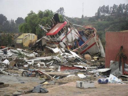
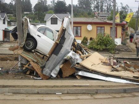
Tsunami Chile 27 February 2010
|
|
|
- Ada Hancock
- 5 years ago
- Views:
Transcription

1 EUROPEAN COMMISSION DIRECTORATE GENERAL JRC JOINT RESEARCH CENTRE Institute for the Protection and Security of the Citizen Global Security and Crisis Management Unit CriTech Wednesday, 03 March 2010 Tsunami Chile 27 February 2010 Part 3: Estimation of Coastal inundation Generals The objective of Tsunami simulations changes with the time elapsed from the time of the event (see Appendix A type of Tsunami calculations). While the initial calculations, performed automatically few minutes after the event, had the objective the identification of the coastal section affected by the Tsunami, the objective now is to identify more precisely which are the cities and villages that could have been inundated by the Tsunami waves. The presence of the Tsunami waves on-shore could have amplified the impact of the earthquake and thus these could be the most damaged areas; this information could help in prioritizing the relief efforts. At the moment the exact locations of the inundated areas are unknown or partially known. The knowledge of the water height off-shore is not sufficient to judge the possibility of inundation. In some cases high water level on the shore connected with steep shore prevents the possibility of damage on the coast. Figure 1 Finite fault model - Crust deformation and tsunami wave height with indication of possible inundated locations Inundation calculations require very high resolution data for bathymetry and topography (as shown in previous events like Samoa 2009) which is not available for Chile. It is impossible to calculate precisely the exact inundation extent; nevertheless a preliminary indication of the potential inundated locations is possible. Early Warning calculations were performed using JRC-SWAN model while for these more detailed calculations the JRC model HyFlux2 has been used. The identified locations have also been compared with GIS extracted flat areas and with the available information present in media reports. The picture above shows the locations with an indication of the confirmation or not by media reports. Joint Research Centre, I Ispra (VA), Italy 1
 1 for the bathymetry/topography, while for the crust deformation the Finite Fault Model solution has been adopted 2 Fig.")
2 Coastal Inundation simulations The calculations have been performed using SRTM30 PLUS Global topography (v 5.0) 1 for the bathymetry/topography, while for the crust deformation the Finite Fault Model solution has been adopted 2 Fig. 1 shows the initial deformation, which was applied on the initial water surface levels as well as on the bathymetry/topography, assuring at instant 0 the conservation of the total mass of liquid on each control volume of the space domain. Cascade simulations have been set-up in order to simulate coastal inundation. In the present report the calculations listed in Table 1 are shown. For all the simulations the calculation time is of 3 hour. Calculation Grid size Latmin Latmax LonMin LonMax Coarse-dx.1800 (1 min) Coarse-dx.900 (0.5 min) coarse-dx.300-sexta_quinta coarse-dx.300-octava_septima coarse-dx.300-novena coarse-dx.300-robinson_crusoe Table 1 - Simulations Some of the relevant maps produced by the simulations are listed in Table 2. Gray light Green Yellow Orange Red Max. water elevation (maps) Run-up elevation (m) <0.2 <0.3 <30 Inundation distance (m) >3.2 >4.8 >480 Magenta dark Table 2 - Maps produced by coastal simulations, see figure below for the definition of quantities Joint Research Centre, I Ispra (VA), Italy 2
3 The figure below represents the distribution of wave heights along the latitude. The red dots are measured data, the blue diamonds are locations evaluated with the JRC-SWAN code (the model used for early warning calculations), the orange diamonds are the locations evaluated with the Hyflux code. The lines above indicate the locations considered inundated. Within all these locations we have identified the table below which represents 16 locations in which the calculations indicated potential inundation, ordered by approaching wave height. Of these 5 have been confirmed by reading media reports. In the next days more information will be available and it will be possible to confirm other locations or add or remove locations. The locations indicated do not mean an exact point but indicate an area around which inundation could be found. In the table the values ontained with SWAN are also reported; in general these values are higher than the ones obtained with Hyflux2, as it can beseen also by the plot above, but the general trend is conserved among the two codes. Joint Research Centre, I Ispra (VA), Italy 3
4 Location Latitude Longitude Wave Height (m) (SWAN) Time Max (hh:mm) Inundation confirmed Curanipe (6.2) 01:41 CONFIRMED Constitución (3.7) 01:03 CONFIRMED Talcahuano (3.3) 02:09 CONFIRMED Llico (3.4) 01:55 NOT-CONFIRMED San Antonio (3.4) 01:19 CONFIRMED Los Morros (3.6) 00:38 CONFIRMED Dichato (3.6) 00:38 CONFIRMED Pullay (2.1) 01:30 CONFIRMED La Greda (1.7) 00:44 NOT-CONFIRMED La Laguna (2.0) 00:41 NOT-CONFIRMED Algarrobo (1.9) 01:31 NOT-CONFIRMED Papudo (1.4) 02:36 NOT-CONFIRMED Lebu (2.1) 00:41 CONFIRMED Concón (1.7) 00:20 NOT-CONFIRMED La Ligua (2.3) 00:05 NOT-CONFIRMED Puerto Saavedra (2.0) 02:32 NOT-CONFIRMED Conchalí (1.3) 02:32 NOT-CONFIRMED Valparaíso (1.2) 00:40 NOT-CONFIRMED Tongoy (0.5) 02:38 NOT-CONFIRMED In the following sections a more detailed analysis of each of the 16 locations is indicated. The locations are ordered by Administrative Entities. The figure below reports the behavior of the wave in the location which was mostly affected, which is the one between and that includes the locations of Curanipe and Pelluhe and other small villages. It is interesting to note that, although the fault was very close to the coast and even included part of the coast, the main wave that caused most damage occurred after 1.5 h from the earthquake. Both JRC-SWAN and Hyflux show a very similar trend with a second large wave at this time. This is also confirmed by one measurement that was not very close to this location but that shows a second wave at about 100 min and then the measurement is broken. Joint Research Centre, I Ispra (VA), Italy 4
,")
5 Joint Research Centre, I Ispra (VA), Italy 5
,")
6 Overall Map Joint Research Centre, I Ispra (VA), Italy 6
,")
7 Septima, Octava Region Dichato Talcahuano Costitution Lebu Pelluhe, Curanipe Joint Research Centre, I Ispra (VA), Italy 7
8 Dichato Joint Research Centre, I Ispra (VA), Italy 8
,")
9 Joint Research Centre, I Ispra (VA), Italy 9
,")
10 Talcahuano Joint Research Centre, I Ispra (VA), Italy 10
,")
11 Costitution Joint Research Centre, I Ispra (VA), Italy 11
, Italy")
12 Lebu Joint Research Centre, I Ispra (VA), Italy 12

13 Pelluhe, Curanipe Joint Research Centre, I Ispra (VA), Italy 13
, Italy 14")
14 Llico Joint Research Centre, I Ispra (VA), Italy 14
,")
15 Sexta Quinta Region Tongoy Concon La Greda Papudo Conchail, Los Vilo La Ligua La Laguna San Antonio Valparaiso Alcarroco Joint Research Centre, I Ispra (VA), Italy 15
,")
16 Tongoy Joint Research Centre, I Ispra (VA), Italy 16
,")
17 Concon Joint Research Centre, I Ispra (VA), Italy 17
,")
18 La Greda, Oil refinery Oil refinery? Joint Research Centre, I Ispra (VA), Italy 18
,")
19 Papudo Joint Research Centre, I Ispra (VA), Italy 19
, Italy")
20 Conchail, Los Vilos Joint Research Centre, I Ispra (VA), Italy 20
,")
21 La Ligua Joint Research Centre, I Ispra (VA), Italy 21
,")
22 La Laguna Joint Research Centre, I Ispra (VA), Italy 22
,")
23 San Antonio Joint Research Centre, I Ispra (VA), Italy 23
,")
24 Valparaiso Joint Research Centre, I Ispra (VA), Italy 24
,")
25 Algarroco Joint Research Centre, I Ispra (VA), Italy 25

26 Novena Region P.ssavedra Isla Mocha Isla Robinson Crusoe Joint Research Centre, I Ispra (VA), Italy 26
, Italy")
27 P.ssavedra No water surface graphs are available, but populate area could be effected by inundation Joint Research Centre, I Ispra (VA), Italy 27
,")
28 Isla Mocha Joint Research Centre, I Ispra (VA), Italy 28
, Italy")
29 Isla Robinson Crusoe Joint Research Centre, I Ispra (VA), Italy 29
30 Appendix A Types of Tsunami calculations Several types of calculations and each of them has its own merit and needs. Near-real time calculations o These are performed very quickly after an event and can only use the information available min after the event. The fault mechanism is not very well known (conservative assumptions must be done) and the position or the depth is not precise at the beginning. o The nodalisation is rather coarse (cell size between 2 and 8 km) to shorten the calculation time. o The objective of these calculation is the identification of the affected locations without pretending to exactly predict the height in all the locations. Grid scenario calculations o These are performed before an event for all likely tsunami scenarios. General assumptions on the fault mechanism must be done (conservative). o The nodalisation is rather coarse (cell size between 2 and 8 km) to shorten the calculation time a limit the data volume. o The objective of these calculation is the same as the near real-time calculations, but with even faster response times: calculations are not performed but alert systems can look up the scenario results in a database. Post event calculations o They are performed one or two days after an event when more information is available on the fault mechanism. o The nodalisation becomes more detailed (cell size between 200 and 900m) in order to accurately estimate the results. o The objective is to identify more precisely the locations and try to estimate the runup height and the potential damage in the various coastal areas. In case an impact assessment is requested, inundation calculations are performed. In this case it is necessary to increase the detail level by reducing the cell size, i.e. down to 10-20m. The results are affected by the precision of the available topography and bathymetry, buildings, infrastructures, etc. Risk assessment and risk management calculations o These are performed before an event and are based on historical events. o These calculations are aimed at preparing evacuation plans in case of tsunami. They are very much site specific and in general it is necessary to perform very detailed calculations reducing the cell size down to 5-20m. Correspondingly also the bathymetry has to be specified with extreme detail which is not available worldwide. The GDACS system is triggering near-real time calculations, which provide the appropriate information for its alerting functions.. Joint Research Centre, I Ispra (VA), Italy 30
Tsunami and earthquake in Chile Part 2
 EUROPEAN COMMISSION DIRECTORATE GENERAL JRC JOINT RESEARCH CENTRE Institute for the Protection and Security of the Citizen Global Security and Crisis Management Unit CriTech Sunday, 28 February 2010 Executive
SCIENCE OF TSUNAMI HAZARDS
 SCIENCE OF TSUNAMI HAZARDS ISSN 8755-6839 Journal of Tsunami Society International Volume 31 Number 4 2012 RESPONSE OF THE GDACS SYSTEM TO THE TOHOKU EARTHQUAKE AND TSUNAMI OF 11 MARCH 2011 Annunziato,
TSUNAMI GRID CALCULATION DATABASE AND THE JRC GLOBAL TSUNAMI CALCULATION SYSTEM
 Presentation of CRITECH Action November 2007 1 TSUNAMI GRID CALCULATION DATABASE AND THE JRC GLOBAL TSUNAMI CALCULATION SYSTEM A. Annunziato IDRC Davos August 2008 Content Presentation of CRITECH Action
Crisis Management and Natural Disasters Overview of JRC operational or pre-operational activities A. Annunziato, D. Al-Khudhairy
 Papagayo, Costarica 3-4 November 2009 Security Science and The Americas 1 Joint Research Centre (JRC) Crisis Management and Natural Disasters Overview of JRC operational or pre-operational activities A.
REAL-TIME TSUNAMI INUNDATION FORECAST STUDY IN CHIMBOTE CITY, PERU
 REAL-TIME TSUNAMI INUNDATION FORECAST STUDY IN CHIMBOTE CITY, PERU Nabilt Moggiano Supervisor: Kenji SATAKE MEE16720 ABSTRACT For rapid forecast of tsunami inundation during a tsunamigenic event, we constructed
Numerical investigation of the November 17, 2015 anomaly in the harbor of Crotone, Ionian Sea
 Numerical investigation of the November 17, 2015 anomaly in the harbor of Crotone, Ionian Sea F. Zaniboni, A. Armigliato, G. Pagnoni, M. A. Paparo, S. Tinti Dipartimento di Fisica e Astronomia, Alma Mater
THE TSUNAMI ASSESSMENT MODELLING SYSTEM BY THE JOINT RESEARCH CENTRE
 THE TSUNAMI ASSESSMENT MODELLING SYSTEM BY THE JOINT RESEARCH CENTRE Alessandro Annunziato European Commission Joint Research Centre Via Fermi 1, 21020 Ispra, Italy EMAIL: alessandro.annunziato@jrc.it
I&CLC2000 in support to new policy initiatives (INSPIRE, GMES,..)
") I&CLC2000 in support to new policy initiatives (INSPIRE, GMES,..) Manfred Grasserbauer, Director Joint Research Centre Institute for Environment and Sustainability 1 IMAGE 2000 European mosaic of satellite
I&CLC2000 in support to new policy initiatives (INSPIRE, GMES,..) Manfred Grasserbauer, Director Joint Research Centre Institute for Environment and Sustainability 1 IMAGE 2000 European mosaic of satellite
TSUNAMI HAZARD ASSESSMENT FOR THE CENTRAL COAST OF PERU USING NUMERICAL SIMULATIONS FOR THE 1974, 1966 AND 1746 EARTHQUAKES
 TSUNAMI HAZARD ASSESSMENT FOR THE CENTRAL COAST OF PERU USING NUMERICAL SIMULATIONS FOR THE 1974, 1966 AND 1746 EARTHQUAKES Sheila Yauri Supervisor: Yushiro FUJII MEE10521 Bunichiro SHIBAZAKI ABSTRACT
Tsunami. Harry Yeh Oregon State University. Eastern Japan Earthquake Disaster Briefing at PEER: April 28, 2011
 Tsunami by Harry Yeh Oregon State University Eastern Japan Earthquake Disaster Briefing at PEER: April 28, 2011 Seismic Characteristics Rupture Model (Harvard Seismology) The fault rupture process was
Tsunami Response and the Enhance PTWC Alerts
 Tsunami Response and the Enhance PTWC Alerts Ken Gledhill GeoNet Project Director Chair, Intergovernmental Coordination Group, Pacific Tsunami Warning and Mitigation System (PTWS) Overview 1. Procedures
EVALUATION OF TSUNAMI RISK FOR COASTAL SOUTHERN CALIFORNIA CITIES. Appendix A - Figures
 EVALUATION OF TSUNAMI RISK FOR COASTAL SOUTHERN CALIFORNIA CITIES Appendix A - Figures Figure 1.Map showing major faults of the southern California region. Northwest-trending faults are rightslip in character.
Geographic Information Systems(GIS)
") Geographic Information Systems(GIS) Threat Analysis Techniques Overview What is GIS? Functional capabilities of GIS BCM Process and GIS How to leverage GIS in threat/risk analysis Ron Brown, CBCP Managing
Geographic Information Systems(GIS) Threat Analysis Techniques Overview What is GIS? Functional capabilities of GIS BCM Process and GIS How to leverage GIS in threat/risk analysis Ron Brown, CBCP Managing
TSUNAMI INUNDATION MAPPING PROJECT
 TSUNAMI INUNDATION MAPPING PROJECT Andrés Enríquez Olavarría Errazuriz 254, Playa Ancha, Valparaíso, Chile Telephone: +56 (032) 2266666 e-mail: aenriquez@shoa.cl WEB Site: www.shoa.mil.cl Abstract The
Luca Guerrieri Valerio Comerci Eutizio Vittori
 Earthquake Environmental Effects induced by the 1908 December 28 th Messina earthquake: an in-situ contribute to the Messina supersite (GEO Task DI-09-01a Vulnerability Mapping and Risk Assessment Luca
SIMULATION OF A WORST CASE TSUNAMI SCENARIO FROM THE MANILA TRENCH TO VIETNAM
 SIMULATION OF A WORST CASE TSUNAMI SCENARIO FROM THE MANILA TRENCH TO VIETNAM Nguyen Hong Phuong, Vu Ha Phuong, Pham The Truyen Earthquake Information and Tsunami Warning Centre, VAST OUTLINE Earthquake
Shelf resonance and impact of near field tsunami generated by the 2010 Chile earthquake
 GEOPHYSICAL RESEARCH LETTERS, VOL. 38,, doi:10.1029/2011gl047508, 2011 Shelf resonance and impact of near field tsunami generated by the 2010 Chile earthquake Yoshiki Yamazaki 1 and Kwok Fai Cheung 1 Received
Earthquakes. Chapter Test A. Multiple Choice. Write the letter of the correct answer on the line at the left.
 Earthquakes Chapter Test A Multiple Choice Write the letter of the correct answer on the line at the left. 1. Stress that pushes a mass of rock in two opposite directions is called a. shearing. b. tension.
NUMERICAL SIMULATION OF TSUNAMI PROPAGATION AND INUNDATION ALONG THE RAKHINE COAST AREAS IN MYANMAR
 NUMERICAL SIMULATION OF TSUNAMI PROPAGATION AND INUNDATION ALONG THE RAKHINE COAST AREAS IN MYANMAR Su Hninn Htwe Supervisor: Bunichiro SHIBAZAKI MEE12619 Yushiro FUJII ABSTRACT This study aimed to assess
Mechanism of tsunami generation,propagation and runup -sharing experiences with Japanese
 Mechanism of tsunami generation,propagation and runup -sharing experiences with Japanese Mechanism of tsunami generation Predicting the propagation, runup and inundation of tsunamis Near and far-field
The ITSU System in the Pacific Region and Future Upgrades
 The ITSU System in the Pacific Region and Future Upgrades Eddie Bernard Director, Pacific Marine Environmental Laboratory (PMEL) NOAA/USA Pacific Tsunami Warning Center OPERATIONAL ACTIVITIES SEISMIC DATA
Risk-based land use and spatial planning
 Risk-based land use and spatial planning Miho OHARA International Centre for Water Hazards and Risk Management (ICHARM) Public Works Research Institute PWRI), Japan Under the auspices of UNESCO Introduction
Tsunami Inundation Modeling in the Aegean Sea
 Tsunami Inundation Modeling in the Aegean Sea B. Aydın Akdeniz University, Antalya, Turkey O. Hoto & U. Kânoğlu Middle East Technical University, Ankara, Turkey SUMMARY: The tsunami forecasting system
Lessons Learned from Past Tsunamis Warning and Emergency Response
 UNESCO IOC CTIC US NOAA ITIC Regional Training Workshop on Strengthening Tsunami Warning and Emergency Response Standard Operating Procedures and the Development of the ICG/CARIBE-EWS PTWC New Enhanced
Copernicus Overview. Major Emergency Management Conference Athlone 2017
 Copernicus Overview Major Emergency Management Conference Athlone 2017 Copernicus is a European programme implemented by the European Commission. The services address six thematic areas: land, marine,
Establishment and Operation of a Regional Tsunami Warning Centre
 Establishment and Operation of a Regional Tsunami Warning Centre Dr. Charles McCreery, Director NOAA Richard H. Hagemeyer Pacific Tsunami Warning Center Ewa Beach, Hawaii USA Why A Regional Tsunami Warning
NUMERICAL SIMULATION AS GUIDANCE IN MAKING TSUNAMI HAZARD MAP FOR LABUAN ISLAND
 NUMERICAL SIMULATION AS GUIDANCE IN MAKING TSUNAMI HAZARD MAP FOR LABUAN ISLAND MOHD RIDZUAN bin Adam Supervisor: Fumihiko IMAMURA MEE09199 ABSTRACT At the northeast end of the South China Sea, tsunamis
REPORT TO THE PLANNING, TRANSPORTATION AND PROTECTIVE SERVICES COMMITTEE MEETING OF JUNE 26, 2013
 PPS/PS 2013-07 REPORT TO THE PLANNING, TRANSPORTATION AND PROTECTIVE SERVICES COMMITTEE MEETING OF JUNE 26, 2013 SUBJECT UPDATES TO THE CAPITAL REGIONAL DISTRICT MODELLING OF POTENTIAL TSUNAMI INUNDATION
Earthquake Investigation
 Exploration A Earthquake Investigation 1. Obtain a piece of plastic putty and knead it into a rectangular shape. 2. Push the ends of the putty toward the middle. Draw and describe what it looks like below.
2. Tsunami Source Details
 2. Tsunami Source Details The Northland area faces a range of potential tsunamigenic sources that include several local and distant fault systems and underwater landslides. A NIWA study (Goff et al. 2006)
(energy loss is greater with longer wavelengths)
") GEOL 0820 Ramsey Natural Disasters Spring, 2018 LECTURE #9: Tsunami Monitoring & Mitigation Date: 8 February 2018 I. Characteristics (con t): shoaling: o process of wave height increase and breaking as
GEOL 0820 Ramsey Natural Disasters Spring, 2018 LECTURE #9: Tsunami Monitoring & Mitigation Date: 8 February 2018 I. Characteristics (con t): shoaling: o process of wave height increase and breaking as
Uses of free satellite imagery for Disaster Risk Reduction (DRR)
") Centre of Applied Geoscience, Disaster Risk Reduction Research Group, School of Earth and Environmental Science, University of Portsmouth, UK Uses of free satellite imagery for Disaster Risk Reduction
Centre of Applied Geoscience, Disaster Risk Reduction Research Group, School of Earth and Environmental Science, University of Portsmouth, UK Uses of free satellite imagery for Disaster Risk Reduction
DATA BASE DEVELOPMENT OF ETA (ESTIMATED TIME OF ARRIVAL) FOR TSUNAMI DISASTER MITIGATION AT SOUTHWESTERN CITIES OF ACEH, INDONESIA
 FOR TSUNAMI DISASTER MITIGATION AT SOUTHWESTERN CITIES OF ACEH, INDONESIA") 6 th South China Sea Tsunami Workshop Nanyang Technology University, Singapore, 6-8 November 2013 DATA BASE DEVELOPMENT OF ETA (ESTIMATED TIME OF ARRIVAL) FOR TSUNAMI DISASTER MITIGATION AT SOUTHWESTERN
6 th South China Sea Tsunami Workshop Nanyang Technology University, Singapore, 6-8 November 2013 DATA BASE DEVELOPMENT OF ETA (ESTIMATED TIME OF ARRIVAL) FOR TSUNAMI DISASTER MITIGATION AT SOUTHWESTERN
Predicting tsunami waves and currents on the West Coast of Canada: A case study for Ucluelet, BC
 Predicting tsunami waves and currents on the West Coast of Canada: A case study for Ucluelet, BC Josef Cherniawsky, Kelin Wang and Roy Walters Institute of Ocean Sciences, Fisheries & Oceans Canada Pacific
"The Big One" by sea and not by land
 "The Big One" by sea and not by land By Los Angeles Times, adapted by Newsela staff on 03.24.14 Word Count 629 Surfer Lee Johnson emerges from the water at San Onofre State Beach, Calif., with the twin
Welcome LESSLOSS Workshop
 Welcome LESSLOSS Workshop Alois J. Sieber acting Director Belgirate 19 July 2007 Page 1 JRC s Mission to provide customer-driven scientific and technical support for the conception, development, implementation
Geospatial application in Kiribati
 Geospatial application in Kiribati ICC-21 ST RESAP (9 TH TO 13 TH OCTOBER, 2017) BANGKOK, THAILAND Outline Kiribati Profile Natural disasters in Kiribati Achievements Challenges/Issues Ways forward 1 Kiribati
Tsunami waves swept away houses and cars in northern Japan and pushed ships aground.
 Japan was struck by a magnitude 8.9 earthquake off its northeastern coast Friday. This is one of the largest earthquakes that Japan has ever experienced. In downtown Tokyo, large buildings shook violently
Wainui Beach Management Strategy (WBMS) Summary of Existing Documents. GNS Tsunami Reports
 Summary of Existing Documents. GNS Tsunami Reports") Wainui Beach Management Strategy (WBMS) Summary of Existing Documents GNS Tsunami Reports a) Review of Tsunami Hazard and Risk in New Zealand ( National Risk Report ) b) Review of New Zealand s Preparedness
Wainui Beach Management Strategy (WBMS) Summary of Existing Documents GNS Tsunami Reports a) Review of Tsunami Hazard and Risk in New Zealand ( National Risk Report ) b) Review of New Zealand s Preparedness
REAL-TIME TSUNAMI INUNDATION PREDICTION USING OFFSHORE TSUNAMI OBSERVATION. Daisuke TATSUMI 1 and Takashi TOMITA 1
 REAL-TIME TSUNAMI INUNDATION PREDICTION USING OFFSHORE TSUNAMI OBSERVATION Daisuke TATSUMI and Takashi TOMITA The previous real-time tsunami prediction based on the inversion method and the linear superposition
Predicting Tsunami Inundated Area and Evacuation Road Based On Local Condition Using GIS
 IOSR Journal of Environmental Science, Toxicology and Food Technology (IOSR-JESTFT) ISSN: 2319-2402, ISBN: 2319-2399. Volume 1, Issue 4 (Sep-Oct. 2012), PP 05-11 Predicting Tsunami Inundated Area and Evacuation
PROTECTING MONUMENTS AND HISTORICAL SETTINGS FROM THE NEXT EARTHQUAKE
 PROTECTING MONUMENTS AND HISTORICAL SETTINGS FROM THE NEXT EARTHQUAKE E. PAPADIMITRIOU & L. PELLI EUROPEAN CENTER OF PREVENTING & FORECASTING OF EARTHQUAKES Confronting the problem SEISMIC RISK R SEISMIC
Features of Tsunami height according to type of coastal landforms 2011 Tohoku oki tsunami case
 Features of Tsunami height according to type of coastal landforms 2011 Tohoku oki tsunami case (70 Nobuhisa Matta (Disaster Mitigation Research Center Nagoya Univ.) July 3 rd, 2013, at Taipei Outline +
Coastal Inundation Forecasting Demonstration Project CIFDP. Flood Forecasting Initiative-Advisory Group (FFI-AG 3), Geneva, 5-7 Dec, 2017
, Geneva, 5-7 Dec, 2017") Coastal Inundation Forecasting Demonstration Project CIFDP Flood Forecasting Initiative-Advisory Group (FFI-AG 3), Geneva, 5-7 Dec, 2017 Coastal Flooding & Vulnerable Populations Coastal populations are
Coastal Inundation Forecasting Demonstration Project CIFDP Flood Forecasting Initiative-Advisory Group (FFI-AG 3), Geneva, 5-7 Dec, 2017 Coastal Flooding & Vulnerable Populations Coastal populations are
I. Locations of Earthquakes. Announcements. Earthquakes Ch. 5. video Northridge, California earthquake, lecture on Chapter 5 Earthquakes!
 51-100-21 Environmental Geology Summer 2006 Tuesday & Thursday 6-9:20 p.m. Dr. Beyer Earthquakes Ch. 5 I. Locations of Earthquakes II. Earthquake Processes III. Effects of Earthquakes IV. Earthquake Risk
Did a submarine landslide contribute to the 2011 Tohoku tsunami?
 Press Release Did a submarine landslide contribute to the 2011 Tohoku tsunami? 1. Key points Large tsunami amplitudes in Northern Tohoku (Sanriku) suggest that a secondary tsunami source lies offshore
Sentinel Asia Tsunami Working Group
 Sentinel Asia Tsunami Working Group Co-Chairman: Prof. Shunichi Koshimura Abdul Muhari, PhD 4 th Joint Project Team Meeting (JPTM 2017): Sentinel Asia STEP 3 Abdul MUHARI, PhD Ministry of Marine Affairs
Cascadia Seismic Event Planning for the Maritime Community
 Cascadia Seismic Event Planning for the Maritime Community Jonathan Allan, Oregon Dept. of Geology and Mineral Industries Presentation to Annual Pacific Northwest Waterways Association Meeting (PNWA) October
Tsunami Inundation Modelling for Bay of Plenty - Executive Summary March 2013
 Tsunami Inundation Modelling for Bay of Plenty - Executive Summary March 2013 1 Inundation Modelling for the Bay of Plenty Executive Summary Tsunami Inundation Modelling for Bay of Plenty - Executive
Field Survey of the 27 February 2010 Chile Tsunami
 Pure Appl. Geophys. 168 (211), 1989 21 Ó 211 Springer Basel AG DOI 1.17/s24-11-283-5 Pure and Applied Geophysics Field Survey of the 27 February 21 Chile Tsunami HERMANN M. FRITZ, 1 CATHERINE M. PETROFF,
WERA Ocean Radar Capability of Real-Time Tsunami Detection
 WERA Ocean Radar Capability of Real-Time Tsunami Detection Dr. Anna Dzvonkovskaya Helzel Messtechnik GmbH Kaltenkirchen, GERMANY e-mail: dzvonkovskaya@helzel.com member of and Worldwide WERA HF Ocean Radar
Coseismic slip model
 Figure 3 - Preliminary highly smoothed model of coseismic slip for the 11 March UCL Institute for Risk & Disaster Reduction Magnitude 9.0 (JMA scale) earthquake Occurred at 02:46:23 pm local time near
Outline of Guideline for Development and Utilization of Tsunami Disaster Management Map
 Outline of Guideline for Development and Utilization of Tsunami Disaster Management Map Port and Airport Research Institute, Japan The Overseas Coastal Area Development Institute of Japan Ports and Harbours
The U.S. Geological Survey (USGS) National Earthquake Information Center (NEIC)
 National Earthquake Information Center (NEIC)") The U.S. Geological Survey (USGS) National Earthquake Information Center (NEIC) Gavin Hayes U.S. Geological Survey, National Earthquake Information Center NEIC Mission NEIC - The People 24x7 Operations
The U.S. Geological Survey (USGS) National Earthquake Information Center (NEIC) Gavin Hayes U.S. Geological Survey, National Earthquake Information Center NEIC Mission NEIC - The People 24x7 Operations
Interpretive Map Series 24
 Oregon Department of Geology and Mineral Industries Interpretive Map Series 24 Geologic Hazards, and Hazard Maps, and Future Damage Estimates for Six Counties in the Mid/Southern Willamette Valley Including
Dr. ELIAS A., International Day for Disaster Risk Reduction, AUB - 15 Oct 2012
 3/3/14 Dr. Ata ELIAS, Geology department AUB Outline 1. Tsunami events: 2. The physical and geological tsunami event 3. Global tsunami mitigation efforts Tsunami hazard 1. The tsunami hazard in the Mediterranean
Applied Geoscience and Technology Division SOPAC. Joy Papao, Risk Information Systems Officer
 Joy Papao, Risk Information Systems Officer Secretariat of the Pacific Community SPC 22 Pacific Island States Head office in Noumea, New Caledonia 2 Regional offices (Pohnpei and Honiara) 600 staff 9 Technical
Storm Surge Modelling at the JRC. A. Annunziato
 Storm Surge Modelling at the JRC A. Annunziato Storm Surge Activities The following modelling activities are carried out at JRC Tsunami wave height forecast Cyclones Storm Surge The activities are performed
PROTECTING MONUMENTS AND HISTORICAL SETTINGS FROM THE NEXT EARTHQUAKE
 PROTECTING MONUMENTS AND HISTORICAL SETTINGS FROM THE NEXT EARTHQUAKE R.PAPADHMHTRIOU, L.PELLI EUROPEAN CENTER OF PREVENTING & FORECASTING OF EARTHQUAKES Confronting the problem SEISMIC RISK R SEISMIC
EC Funded Research on Tsunamis in the. Achievements and Perspectives
 EC Funded Research on Tsunamis in the FP6 and FP7 frameworks: Achievements and Perspectives Stefano Tinti University of Bologna stefano.tinti@unibo.it International Workshop on Disaster Risk Reduction
Magnitude 7.7 QUEEN CHARLOTTE ISLANDS REGION
 A major 7.7 magnitude earthquake struck at 8:04 PM local time in western British Columbia, Canada. The epicenter is located on Moresby Island, the southern large island in the Queen Charlotte Islands region.
TSUNAMI PROPAGATION AND INUNDATION MODELINGS ALONG SOUTH-EAST COAST OF PAPUA NEW GUINEA
 TSUNAMI PROPAGATION AND INUNDATION MODELINGS ALONG SOUTH-EAST COAST OF PAPUA NEW GUINEA Martin WAREK Supervisor: Yushiro FUJII MEE12620 Bunichiro SHIBAZAKI ABSTRACT This study covers tsunami generation,
Earthquake Epicenters
 TEACHER RESOURCES Inquiry Lab Earthquake Epicenters DATASHEET Teacher Notes This lab has students use three seismograms to locate the epicenter of an earthquake (covers standard 6.1.g). TIME REQUIRED One
Deadly Earthquake Strikes Peru
 Deadly Earthquake Strikes Peru KEY POINTS On 14 January 2018, a magnitude-7.1 earthquake struck off the coast of Peru. At least two people have been reported dead, with dozens more left injured or homeless.
Predicting of Tsunami Inundation Area based on Propagation and Runup Numerical Model in Pacitan City
 Predicting of Tsunami Inundation Area based on Propagation and Runup Numerical Model in Pacitan City 1 Agus Suharyanto, 1 Alwafi Pujiraharjo, 2 Adipandang Yudono, 3 Keisuke Murakami, and 3 Chikashi Deguchi
SOURCE INVERSION AND INUNDATION MODELING TECHNOLOGIES FOR TSUNAMI HAZARD ASSESSMENT, CASE STUDY: 2001 PERU TSUNAMI
 Paper No. TS-4-1 SOURCE INVERSION AND INUNDATION MODELING TECHNOLOGIES FOR TSUNAMI HAZARD ASSESSMENT, CASE STUDY: 2001 PERU TSUNAMI Bruno Adriano 1, Shunichi Koshimura 2 and Yushiro Fujii 3 ABSTRACT The
WESTERN STATES SEISMIC POLICY COUNCIL POLICY RECOMMENDATION Earthquake and Tsunami Planning Scenarios
 WESTERN STATES SEISMIC POLICY COUNCIL POLICY RECOMMENDATION 18-1 Earthquake and Tsunami Planning Scenarios Policy Recommendation 18-1 WSSPC strongly encourages states, provinces, territories, First Nations,
NUMERICAL SIMULATIONS FOR TSUNAMI FORECASTING AT PADANG CITY USING OFFSHORE TSUNAMI SENSORS
 NUMERICAL SIMULATIONS FOR TSUNAMI FORECASTING AT PADANG CITY USING OFFSHORE TSUNAMI SENSORS Setyoajie Prayoedhie Supervisor: Yushiro FUJII MEE10518 Bunichiro SHIBAZAKI ABSTRACT We conducted numerical simulations
Introduction to Environmental Geology, 5e Case History: Indonesian Tsunami Indonesian Tsunami (2) Introduction Historic Tsunamis
 Introduction Historic Tsunamis") 1 2 3 4 5 6 7 8 9 Introduction to Environmental Geology, 5e Chapter 7 Tsunami Case History: Indonesian Tsunami December 26, 2004, within a few hours, close to 250,000 people were killed With no warning
1 2 3 4 5 6 7 8 9 Introduction to Environmental Geology, 5e Chapter 7 Tsunami Case History: Indonesian Tsunami December 26, 2004, within a few hours, close to 250,000 people were killed With no warning
Contribution of HPC to the mitigation of natural risks. B. Feignier. CEA-DAM Ile de France Département Analyse, Surveillance, Environnement
 Contribution of HPC to the mitigation of natural risks B. Feignier CEA-DAM Ile de France Département Analyse, Surveillance, Environnement Introduction Over the last 40 years, the increase in computational
7.8M Earthquake in Nepal Situation Report No. 1
 EUROPEAN COMMISSION JOINT RESEARCH CENTRE Institute for the Protection and Security of the Citizen Global Security and Crisis Management Unit Sunday, 26 April 2015 7.8M Earthquake in Nepal Situation Report
Disclaimer. This report was compiled by an ADRC visiting researcher (VR) from ADRC member countries.
 from ADRC member countries.") Disclaimer This report was compiled by an ADRC visiting researcher (VR) from ADRC member countries. The views expressed in the report do not necessarily reflect the views of the ADRC. The boundaries and
Disclaimer This report was compiled by an ADRC visiting researcher (VR) from ADRC member countries. The views expressed in the report do not necessarily reflect the views of the ADRC. The boundaries and
Magnitude 6.5 OFFSHORE NORTHERN CALIFORNIA
 A powerful offshore earthquake that struck near the Northern California coast left a hodgepodge of debris for communities to sort through Sunday but spared residents any serious injury. After 25,000 people
Special edition paper Development of Shinkansen Earthquake Impact Assessment System
 Development of Shinkansen Earthquake Impact Assessment System Makoto Shimamura*, Keiichi Yamamura* Assuring safety during earthquakes is a very important task for the Shinkansen because the trains operate
Introduction to Environmental Geology, 5e
 Lecture Presentation prepared by X. Mara Chen, Salisbury University Introduction to Environmental Geology, 5e Edward A. Keller Chapter 7 Tsunami Case History: Indonesian Tsunami December 26, 2004, within
DRAFT - Tsunami Response Plan Playbook Santa Cruz Harbor Maritime Community
 DRAFT - Tsunami Response Plan Playbook Santa Cruz Harbor Maritime Community Page 1 Best to display on 11X17 paper Purpose and Use of this Real-time Tsunami Response Plan Playbook PURPOSE: This product
Modeling of the 2011 Tohoku-oki. oki Tsunami and it s s impacts to Hawaii
 WAVES 11, KONA HAWAI`I Modeling of the 2011 Tohoku-oki oki Tsunami and it s s impacts to Hawaii Yoshiki Yamazaki 1, Volker Roeber 1, Kwok Fai Cheung 1 and Thorne Lay 2 1 Department of Ocean and Resources
Application of a GIS for Earthquake Hazard Assessment and Risk Mitigation in Vietnam
 Application of a GIS for Earthquake Hazard Assessment and Risk Mitigation in Vietnam Nguyen Hong Phuong Earthquake Information and Tsunami Warning Centre, VAST OUTLINE Introduction Fault Source Model and
Damage of Sewage Plant by Tsunami
 Damage of Sewage Plant by Tsunami K. Fujima & Y. Shigihara National Defense Acadfemy, Japan SUMMARY: This work describes a damage assessment of a sewage plant in Shizuoka city by next Tokai earthquake
Development of an M.I.S. for the prevention of hurricane damage on the Mexican coast
 Development of an M.I.S. for the prevention of hurricane damage on the Mexican coast A. Contreras, R. Silva & G. Diaz Institute* de Ingenieria UNAM, Grupo de Ingenieria de Costas y Puertos. Mexico D.F.
E F F I S E u r o p e a n F o r e s t F i r e I n f o r m a t i o n S y s t e m. G W I S G l o b a l W i l d f i r e I n f o r m a t i o n S y s t e m
 E F F I S E u r o p e a n F o r e s t F i r e I n f o r m a t i o n S y s t e m G W I S G l o b a l W i l d f i r e I n f o r m a t i o n S y s t e m J. San-Miguel-Ayanz EFFIS Team jrc-effis@jrc.ec.europa.eu
Climate Change Impacts and Adaptation for Coastal Transport Infrastructure in Caribbean SIDS
 UNCTAD National Workshop Saint Lucia 24 26 May 2017, Rodney Bay, Saint Lucia Climate Change Impacts and Adaptation for Coastal Transport Infrastructure in Caribbean SIDS LISCoAsT Large Scale Integrated
Puerto Rico Tsunami Mitigation and Warning Program: Update and Future
 Puerto Rico Tsunami Mitigation and Warning Program: Update and Future Christa G. von Hillebrandt- Andrade, Puerto Rico Seismic Network, UPRM Aurelio Mercado Dept. Marine Sciences, UPRM Status in 1999,
HISTORY OF HEAVY RAINFALL DISASTER INFORMATION IN JAPAN
 transmission, for a state-of-the-art review. In addition, issues expected to arise in the future are discussed. HISTORY OF HEAVY RAINFALL DISASTER INFORMATION IN JAPAN Progress of Rainfall Observation
Probabilistic Tsunami Hazard Analysis. Hong Kie Thio AECOM, Los Angeles
 Probabilistic Tsunami Hazard Analysis Hong Kie Thio AECOM, Los Angeles May 18, 2015 Overview Introduction Types of hazard analysis Similarities and differences to seismic hazard Methodology Elements o
The Role of Science and Technology in Earthquake Hazard Characterization: A Chilean Experience
 The Role of Science and Technology in Earthquake Hazard Characterization: A Chilean Experience STI Contribution to Policy Making on Natural Disaster Resilience APEC Workshop, 1-2 August 2018 Santiago -
Storm Surge Analysis Update Meeting Cross City, Florida June 17, 2014
 Big Bend Coastal Storm Surge Study Storm Surge Analysis Update Meeting Cross City, Florida June 17, 2014 Introductions Risk MAP Project Team FEMA Region IV Florida Division of Emergency Management (FDEM)
4-3-1 Earthquake and Tsunami Countermeasures of Tokyo s
 4-3-1 Earthquake and Tsunami Countermeasures of Tokyo s Sewerage Masahiro Hikino* and Gaku Sato** *Planning Section, Planning and Coordinating Division, Bureau of Sewerage, Tokyo Metropolitan Government
Overview of Consequences of the Tsunami in Thailand and Roles and Activities of the Department of Mineral Resources after the 26 December 2004 Tsunami
 Overview of Consequences of the Tsunami in Thailand and Roles and Activities of the after the 26 December 2004 Tsunami By Mr.Worawoot Tantiwanit, Thailand 1 Earthquake in NW of North Sumatra Island 580
Chapter 4 Earthquakes and Tsunamis
 Geology of the Hawaiian Islands Class 21 30 March 2004 100 100 100 96 A B C D F Exam Scores 95 94 94 90 85 83 83 83 Mean 72 67 61 59 59 55 54 41 Mean = 78.5 Median = 83 Any Questions? Chapter 4 Earthquakes
Chapter 4 Earthquakes and Tsunamis. Geology of the Hawaiian Islands. Any Questions? Class March Mean = 78.
 Geology of the Hawaiian Islands Class 21 30 March 2004 Any Questions? 100 100 100 96 A B C D F Exam Scores 95 94 94 90 85 83 83 83 Mean 72 67 61 59 59 55 54 41 Mean = 78.5 Median = 83 Chapter 4 Earthquakes
Development of Spatial Information Database of Building Damage and Tsunami Inundation Areas following the 2010 Chile Earthquake
 Development of Spatial Information Database of Building Damage and Tsunami Inundation Areas following the 2010 Chile Earthquake Fumio YAMAZAKI 1, Yoshihisa MARUYAMA 2, Hiroyuki MIURA 3, Shizuko MATSUZAKI
FLOOD HAZARD AND RISK ASSESSMENT IN MID- EASTERN PART OF DHAKA, BANGLADESH
 FLOOD HAZARD AND RISK ASSESSMENT IN MID- EASTERN PART OF DHAKA, BANGLADESH Muhammad MASOOD MEE07180 Supervisor: Prof. Kuniyoshi TAKEUCHI ABSTRACT An inundation simulation has been done for the mid-eastern
4. Regions Northland Region Distant Eastern source: South America (Chile/Peru)
") 4. Regions Maximum water surface elevation images are presented below for tsunamis generated from the sources discussed above; Distant Eastern source: South America (Chile/Peru), Regional Eastern source:
4. Regions Maximum water surface elevation images are presented below for tsunamis generated from the sources discussed above; Distant Eastern source: South America (Chile/Peru), Regional Eastern source:
JRC Emergency Reporting - Activation #14-25 July 2018 EUROPEAN COMMISSION. Lao People's Democratic Republic Flash Flood due to Dam Collapsing
 EUROPEAN COMMISSION JOINT RESEARCH CENTRE 30 July 2018 16:00 UTC Lao People's Democratic Republic Flash Flood due to Dam Collapsing Glide Number: FF-2018-000118-LAO 23 July - ongoing UPDATE # 1 - Results
Tsunami Waveform Inversion based on Oceanographic Radar Data
 Research Institute for Applied Mechanics Workshop of Oceanographic Radar 12-13 December 2012 1 Tsunami Waveform Inversion based on Oceanographic Radar Data Ryotaro Fuji 1), Hirofumi Hinata 1), Tomoyuki
Education and Drill Activities against Tsunami Disasters in Chile and Japan -WG4a Activities-
 Education and Drill Activities against Tsunami Disasters in Chile and Japan -WG4a Activities- Dr. F. Miura, Yamaguchi U., Mr. M. Reyes, UV MSc. O. Cifuentes, UDEC, Enhancement of Technology to Develop
VALIDATION OF TSUNAMI INUNDATION MODELING FOR THE 2004 SUMATRA-ANDAMAN EARTHQUAKE FOR MAKING HAZARD MAPS IN PENANG AND LANGKAWI, MALAYSIA
 Synopses of Master Papers Bulletin of IISEE, 47, 11-16, 013 VALIDATION OF TSUNAMI INUNDATION MODELING FOR THE 004 SUMATRA-ANDAMAN EARTHQUAKE FOR MAKING HAZARD MAPS IN PENANG AND LANGKAWI, MALAYSIA Noor
Coupling of Wave and Hydrodynamic Models for Predicting Coastal Inundation: A case study in Jakarta and Semarang
 Coupling of Wave and Hydrodynamic Models for Predicting Coastal Inundation: A case study in Jakarta and Semarang http://peta-maritim.bmkg.go.id/cifdp/maps Nelly Florida Riama,Andri Ramdhani, Andi Eka Sakya,,
EMERGENCY PLANNING IN NORTHERN ALGERIA BASED ON REMOTE SENSING DATA IN RESPECT TO TSUNAMI HAZARD PREPAREDNESS
 EMERGENCY PLANNING IN NORTHERN ALGERIA BASED ON REMOTE SENSING DATA IN RESPECT TO TSUNAMI HAZARD PREPAREDNESS Barbara Theilen-Willige Technical University of Berlin, Institute of Applied Geosciences Department