Storm Surge Modelling at the JRC. A. Annunziato
|
|
|
- Clare Glenn
- 5 years ago
- Views:
Transcription

1 Storm Surge Modelling at the JRC A. Annunziato
2 Storm Surge Activities The following modelling activities are carried out at JRC Tsunami wave height forecast Cyclones Storm Surge The activities are performed in the frame of the Global Disasters Alerts and Coordination System (GDACS) An activity performed in collaboration between UN-OCHA, UNOSAT and the JRC to alert the Humanitarian Community of large disasters


3 GDACS Architecture & functions JTC USGS PDC Analysis & Alerting EMSC Geofon IM SMS FAX JRC Online Calculation System Tsunami travel time Tsunami propagation Cyclones analysis GIS analyses Geo Layers

4
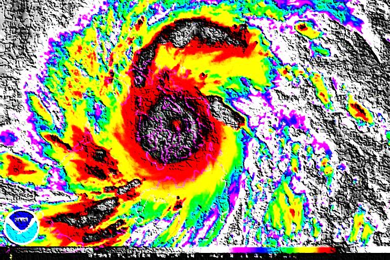
 Vmax = 232 km/h Pc = 932 mbar Winds Rainfall STORM")
5 Tropical Cyclones in GDACS GIOVANNA 9-21 Feb 2012 Madagascar Uragano Categoria 4 (SSHS) Vmax = 232 km/h Pc = 932 mbar Winds Rainfall STORM SURGE
 Tropical Cyclon")


6 Tropical Cyclones: Storm Surge (2/2) Tropical Cyclon Monitoring Centers IRENE Hurricane Aug 2011 TC BULLETINS Track Maximum wind Wind radii WIND RADII TREATMENT by a Monte Carlo Method Vmax Wind Radii HOLLAND S MODEL PRESSURE and WIND FIELDS HyFlux2 ASGARD INUNDATION MAPS WIND INPACT ASSESMENT GDACS
7 Tropical Cyclones Online cyclones track analysis every 6 h in order to identify when the conditions for wind intensity and precipitation may lead to dangerous situations JRC Partners Pacific Disasters Center (track collection and formatting) NOAA (Tropical Rainfall Potential) JRC contribution Track Analysis Storm surge prediction Users Alerting Global Flood Detection System


8 From bulletins to pressure/winds Input: Output: Vmax, Wind radii Pc, Rmax, B, k Bulletins WIND RADII TREATMENT by a Monte Carlo Method Vmax Wind Radii Holland Model parameters: Central Pressure, Max Radius, k (B=f(Vmax,Pn,Pc)
9 Current Technique: Bulletins (G. Franchello, P. Probst, 2010) Based on the reconstruction of the pressure and wind field from the textual bulletins to follow Holland Model WTPN32 PGTW ! MSGID/GENADMIN/JOINT TYPHOON WRNCEN PEARL HARBOR HI//! SUBJ/TROPICAL CYCLONE WARNING//! RMKS/! 1. TYPHOON 24W (NARI) WARNING NR 007! UPGRADED FROM TROPICAL STORM 24W! 01 ACTIVE TROPICAL CYCLONE IN NORTHWESTPAC! MAX SUSTAINED WINDS BASED ON ONE-MINUTE AVERAGE! WIND RADII VALID OVER OPEN WATER ONLY! ---! WARNING POSITION:! Z --- NEAR 15.2N 126.5E! MOVEMENT PAST SIX HOURS DEGREES AT 13 KTS! POSITION ACCURATE TO WITHIN 045 NM! POSITION BASED ON CENTER LOCATED BY SATELLITE! PRESENT WIND DISTRIBUTION:! MAX SUSTAINED WINDS KT, GUSTS 080 KT! WIND RADII VALID OVER OPEN WATER ONLY! RADIUS OF 050 KT WINDS NM NORTHEAST QUADRANT! 025 NM SOUTHEAST QUADRANT! 025 NM SOUTHWEST QUADRANT! 025 NM NORTHWEST QUADRANT! RADIUS OF 034 KT WINDS NM NORTHEAST QUADRANT! 045 NM SOUTHEAST QUADRANT! 050 NM SOUTHWEST QUADRANT! 055 NM NORTHWEST QUADRANT! REPEAT POSIT: 15.2N 126.5E! ---! FORECASTS:! 12 HRS, VALID AT:! Z N 124.9E! MAX SUSTAINED WINDS KT, GUSTS 090 KT! WIND RADII VALID OVER OPEN WATER ONLY! RADIUS OF 064 KT WINDS NM NORTHEAST QUADRANT! 020 NM SOUTHEAST QUADRANT!! LOCATION 50 knots 34 knots 25 NM 50 NM QUADRANT OF 50,34 KNOTS AND THEIR DISTANCE
10 Automatic procedure Every 6h in the Atlantic or 12h in the Pacific we download the bulletin parameters and initialize HYFLUX2 code

11 Dp/Dx, Dp/Dy, Ux, Uy

12 HAIYAN animation

13 GDACS pages for HAIYAN

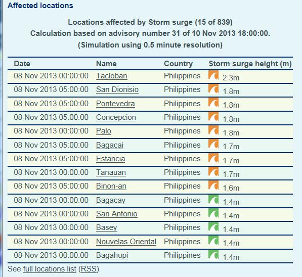
14 Estimated storm surge HAIYAN Typhoon Storm Surge SituaDon published 4/11/2013 (- 4 days before strucking) IdenDficaDon of mostly affected areas Busuanga, Culion And Coron Islands 1.5 m Tacloban 2.8 m Panay Island 1.8 m

15 News coverage with JRC data
16 A new approach based on ECMWF As of 2013, the European Center for Medium Weather Forecast is providing estimations with a much finer grid (50 km -> 16 km) Therefore it is possible to use their pressure and velocity fields to impose to the hydraulic calculations Daily Forecasts related to 00:00 and 12:00 available few hours after the related time (about 6h) for 72h forecast period The maps have to be interpolated and used as boundary conditions to the HYFLUX code Preliminary tests on the basis of an informal agreement with ECMWF for the download of daily forecast in a non-operational mode Advantage is that it is possible to analyse also extra tropical cycones (e.g. St. Jude event 2 weeks ago)

17 Pressure and max wind available

18 Time & Space raster interpolation
19 Pilot calculations with ECMWF Cyclone Year Results SANDY 2010 Good WIPHA 2013 Good PHAILIN 2013 Too low HAIYAN 2013 Too low


20 Sandy Cyclone October 2012 Very promising results in the first comparisons Bulletins Method ECMWF forcing method

21 Landfall area Atlantic City Bulletins Method ECMWF forcing method


22 Sandy October 2012
23
24 1010 Pc (hpa) BT NOAA ECMWF /22/2012 0:00 10/23/2012 0:00 10/24/2012 0:00 10/25/2012 0:00 10/26/2012 0:00 10/27/2012 0:00 10/28/2012 0:00 10/29/2012 0:00 10/30/2012 0:00 10/31/2012 0:00 11/1/2012 0:00
25

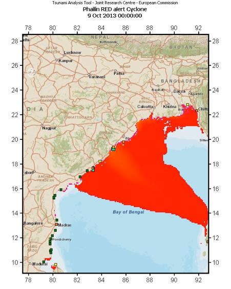
26 PHAILIN October 2013

27


28
29 Phailin 2013 The maximum velocity is strongly underpredicted in ECMWF The minimum pressure is not correctly modelled in ECMWF and thus the maximum impact is underpredicted

30


31 WIPHA October 2013 Very nice results with 2 cyclones at the same time several tide gauges to compare in Japan The behavior is strongly dependent on the history of the cyclone

32 The first affected location in Japan

33 The most off-center location

34 The point of max impact
35 HAIYNAN Cyclone One of the most severe cyclones Philippines: Too few measurements in the impact area Wind Radii model Unable to show the extent of the cyclone Correct estimation of maximum impact in Philippines in the larger damage area ECMWF Forcing model Vietnam Correct extent but maximum wind speed too low and minimum pressure too high Wind Radii model Unable to show the extent of the cyclone Impact extent not yet available ECMWF Forcing model Correct extent and good prediction of sea level measurements Impact extent not yet available


36 Wind Radii vs ECMWF forcing Wider impact But less intense


37 Estimation of cyclone extent Max Height over line between /5.65 and / Height (m) ECMWF Wind Radii MEAS PALAU MEAS YAP Distance (km)

38
39 Comparison of forcing conditions Wind Speed (m/s) ECMWF Wind Radii 11/2/2013 0:00 11/3/2013 0:00 11/4/2013 0:00 11/5/2013 0:00 11/6/2013 0:00 11/7/2013 0:00 11/8/2013 0:00 11/9/2013 0:00 11/10/2013 0:00 11/11/2013 0:00 11/12/2013 0:00 11/13/2013 0: Minimum Pressure (Pa) ECMWF Wind Radii /2/2013 0:00 11/3/2013 0:00 11/4/2013 0:00 11/5/2013 0:00 11/6/2013 0:00 11/7/2013 0:00 11/8/2013 0:00 11/9/2013 0:00 11/10/2013 0:00 11/11/2013 0:00 11/12/2013 0:00 11/13/2013 0:00
40 Other topics on Cyclones esurge: use of altimetry for the establishment of sea level height Off shore altimetric data could be extremely useful to Understand well before landfall which model is better reproducing the current event To suffice areas where no tidal gauge are available (i.e. China)

41 All tracks, w/o considering distance or time (Jason or Cryosat)
42 Altimetry Tracks Analysis However not all the tracks are useful for modelling comparison We need to filter the tracks that fits in space and time with the Hurricane Track DT= 6 h Min Distance=200 km t1 t0-dt t0 Track is selected t1 T1+DT Hurricane eye track Min distance Satellite track t0

")
,")

43 Jason2: Filtering on space (DeltaX=200 km) and time (deltat=6h), only 3 Cryosat tracks are useful 8 Nov 4:30 7 Nov 16:11 7 Nov 3:41


44 NORTH SOUTH


45 7 Nov :11 Wind Radii model 18:00 12:00 7 Nov :11 18:00 12:00 ECWMF Forcing model

46 Sea level behaviour at the eye position along the track

47 Wind radii swh x 0.05 Max Height over track Height at time of track
48 ECMWF Forcing swh x 0.05 Max Height over track Height at time of track


49
50 Conclusions JRC is providing online storm surge calculations for every Tropical Cyclone occurring worldwide During HAIYAN crisis JRC estimation proved to be instrumental in order to identify the most affected areas and task satellite images production Our calculations represent an important support for many groups that trust in our estimations but the quality needs to be continuously verified with sea level measurements New developments, using ECMWF medium forecast, seem promising for medium and low cyclones (SANDY, WIPHA, FRANCISCO) but some problems were identified for large velocity events (PHAILIN, HAIYAN) The use of altimetric data from JASON/CRYOSAT could be quite useful to compare the quality of the model predictions but still work is necessary to have an operational tool
51 Thanks!
Storm surge modeling at JRC and Data Requirements for the GDACS System A. Annunziato Jan 2015 Deltares, Delft (NL)
") Storm surge modeling at JRC and Data Requirements for the GDACS System A. Annunziato 20-21 Jan 2015 Deltares, Delft (NL) Table of Content Why Storm Surge Modelling? The Joint Research Centre The Global
Storm surge modeling at JRC and Data Requirements for the GDACS System A. Annunziato 20-21 Jan 2015 Deltares, Delft (NL) Table of Content Why Storm Surge Modelling? The Joint Research Centre The Global
Crisis Management and Natural Disasters Overview of JRC operational or pre-operational activities A. Annunziato, D. Al-Khudhairy
 Papagayo, Costarica 3-4 November 2009 Security Science and The Americas 1 Joint Research Centre (JRC) Crisis Management and Natural Disasters Overview of JRC operational or pre-operational activities A.
TSUNAMI GRID CALCULATION DATABASE AND THE JRC GLOBAL TSUNAMI CALCULATION SYSTEM
 Presentation of CRITECH Action November 2007 1 TSUNAMI GRID CALCULATION DATABASE AND THE JRC GLOBAL TSUNAMI CALCULATION SYSTEM A. Annunziato IDRC Davos August 2008 Content Presentation of CRITECH Action
Tropical Cyclones and Storm Surge Modelling Activities
 Tropical Cyclones and Storm Surge Modelling Activities New systems developed for the Tropical Cyclones Pamela Probst Alessandro Annunziato George Breyiannis Thomas I. Petroliagkis 2016 EUR 28333 EN This
SH RI Events. Influence From Patterns Of Different Scale
 SH072014 RI Events Influence From Patterns Of Different Scale RI Explanation * Rapid intensification, approximately an increase of 2 Dvorak T-numbers or 30 knots in 24 hours, frequently occurs in JTWC
SCIENCE OF TSUNAMI HAZARDS
 SCIENCE OF TSUNAMI HAZARDS ISSN 8755-6839 Journal of Tsunami Society International Volume 31 Number 4 2012 RESPONSE OF THE GDACS SYSTEM TO THE TOHOKU EARTHQUAKE AND TSUNAMI OF 11 MARCH 2011 Annunziato,
Tokyo, Japan March Discussed By: May Khin Chaw, Kyaw Lwin Oo. Department of Meteorology and Hydrology
 Tokyo, Japan 11-14 March 2014 Discussed By: May Khin Chaw, Kyaw Lwin Oo Department of Meteorology and Hydrology Manpower: Out of DMH s total (1425), we are Working with (780) Staffs. 55% (37) stations
(April 7, 2010, Wednesday) Tropical Storms & Hurricanes Part 2
 Tropical Storms & Hurricanes Part 2") Lecture #17 (April 7, 2010, Wednesday) Tropical Storms & Hurricanes Part 2 Hurricane Katrina August 2005 All tropical cyclone tracks (1945-2006). Hurricane Formation While moving westward, tropical disturbances
Lecture #17 (April 7, 2010, Wednesday) Tropical Storms & Hurricanes Part 2 Hurricane Katrina August 2005 All tropical cyclone tracks (1945-2006). Hurricane Formation While moving westward, tropical disturbances
MODELLING CATASTROPHIC COASTAL FLOOD RISKS AROUND THE WORLD
 MODELLING CATASTROPHIC COASTAL FLOOD RISKS AROUND THE WORLD Nicola Howe Christopher Thomas Copyright 2016 Risk Management Solutions, Inc. All Rights Reserved. June 27, 2016 1 OUTLINE MOTIVATION What we
The Role of PAGASA in Disaster Mitigation
 The Role of PAGASA in Disaster Mitigation Christopher F. Perez 2017 ACTS Workshop on Extreme Weather Forecast and Water Resource Management Hanoi, Vietnam September 26-27, 2017 Tropical Storm AMANG(Mekkhala),
11/17/2017. Memorable Hurricanes of 2004 MET 4532
 MET 4532 2004 Hurricane Season Lecture 31 & 32 2004, 2005, and After 17-20 November 2017 1 2 Memorable Hurricanes of 2004 Hurricane Dates Damage (US) Deaths (US) Charlie (4) 9-14 AUG $14B 10 Ivan (4) 2-24
JRC storm surge system: New developments
 JRC storm surge system: New developments Description of the new systems developed for SSCS & GDACS Pamela Probst Alessandro Annunziato 2017 EUR 29079 EN This publication is a Technical report by the Joint
Earth Observation & forecasting Storm Surges in the North Western Pacific. Mr. Nadao Kohno Japan Meteorological Agency
 Earth Observation & forecasting Storm Surges in the North Western Pacific Mr. Nadao Kohno Japan Meteorological Agency Lesson Outline Introduction JMA s responsibility and work as a RSMC, Tokyo Typhoon
Government of Sultanate of Oman Public Authority of Civil Aviation Directorate General of Meteorology. National Report To
 Government of Sultanate of Oman Public Authority of Civil Aviation Directorate General of Meteorology National Report To Panel on Tropical Cyclones in the Bay of Bengal And Arabian Sea 43rd Session, India
2014/2/25. Earth Observation & forecasting Storm Surges in the North Western Pacific. Lesson Outline. RSMC Tokyo Typhoon Center.
 Earth Observation & forecasting Storm Surges in the North Western Pacific Mr. Nadao Kohno Japan Meteorological Agency Lesson Outline Introduction JMA s responsibility and work as a RSMC, Tokyo Typhoon
Development of Tropical Storm Falcon (Meari) over the Philippines
 over the Philippines") Development of Tropical Storm Falcon (Meari) over the Philippines June 20-27, 2011 At the end of June, 2011, the Philippines were struck again by Tropical storm Falcon (Meari). After gaining strength over
Development of Tropical Storm Falcon (Meari) over the Philippines June 20-27, 2011 At the end of June, 2011, the Philippines were struck again by Tropical storm Falcon (Meari). After gaining strength over
WEDNESDAY 30 TH AUGUST, :57 p.m. Tropical Storm Irma forms in the Atlantic. Don t let your guard down, always #Be Ready.
 Chapter 1 - The Set Up In the days leading up to Irma a series of composed and sobering text messages, presented in truncated form below, from Department of Disaster Management warned us of the pending
Experimental Probabilistic Hurricane Inundation Surge Height (PHISH) Guidance
 Guidance") Experimental Probabilistic Hurricane Inundation Surge Height (PHISH) Guidance DRBC Flood Advisory Committee John Kuhn - NWS/OCWWS Anne Myckow (NWS/MDL), Arthur Taylor (NWS/MDL) SLOSH Sea, Lake and Overland
Experimental Probabilistic Hurricane Inundation Surge Height (PHISH) Guidance DRBC Flood Advisory Committee John Kuhn - NWS/OCWWS Anne Myckow (NWS/MDL), Arthur Taylor (NWS/MDL) SLOSH Sea, Lake and Overland
Disaster Risk Management in India. Kamal Kishore New Delhi, 27 October 2016
 Disaster Risk Management in India Kamal Kishore New Delhi, 27 October 2016 Hazard, Exposure and Vulnerability Disaster Prevention Mitigation Hurricane Matthew: Cuba & Haiti Emergency Response Coordination
NOAA s National Weather Service Philadelphia/Mt. Holly NJ
 Next Briefing Package: Friday, October 2, 2015 no later than 300 PM Hazards and Impacts: Overview: A dangerous weather pattern still threatens our region. Threats include very heavy rainfall, inland river
UPDATE OF REGIONAL WEATHER AND SMOKE HAZE (December 2017)
") UPDATE OF REGIONAL WEATHER AND SMOKE HAZE (December 2017) 1. Review of Regional Weather Conditions for November 2017 1.1 In November 2017, Southeast Asia experienced inter-monsoon conditions in the first
UPDATE OF REGIONAL WEATHER AND SMOKE HAZE (December 2017) 1. Review of Regional Weather Conditions for November 2017 1.1 In November 2017, Southeast Asia experienced inter-monsoon conditions in the first
Extreme Winds in the Western North Pacific. Søren Ott
 in the Western North Pacific Søren Ott Outline Tropical cyclones and wind turbines Modelling extreme winds Validation Conclusions Cat. 4 tropical cyclone IVAN 15 Sept 2004 at landfall near Luisiana, USA
NWS HURRICANES June 3, 2015
 NWS HURRICANES June 3, 2015 Hurricane Season June 1 November 30 2 What s the concern? All tropical systems passing within 125nm of central Maryland since 1950 Mid-Atlantic Hurricanes Greatest Risk: August
Flood Finder Chad 2017
 Flood Finder Chad 2017 Bulletin N 11 11 October 2017 Flood Finder alert system is operational using observed water level data. Based on hydrological forecast, flood alerts are issued at N DJamena, Bongor,
THE TSUNAMI ASSESSMENT MODELLING SYSTEM BY THE JOINT RESEARCH CENTRE
 THE TSUNAMI ASSESSMENT MODELLING SYSTEM BY THE JOINT RESEARCH CENTRE Alessandro Annunziato European Commission Joint Research Centre Via Fermi 1, 21020 Ispra, Italy EMAIL: alessandro.annunziato@jrc.it
Response and Lesson Learned from Typhoon YOLANDA (HAIYAN)
") 9 th NARBO IWRM Training Tagaytay City May 12-19, 2014 Response and Lesson Learned from Typhoon YOLANDA (HAIYAN) Rene B. Paciente Weather Division, PAGASA Philippines OUTLINE 1. Meteorological Informations
9 th NARBO IWRM Training Tagaytay City May 12-19, 2014 Response and Lesson Learned from Typhoon YOLANDA (HAIYAN) Rene B. Paciente Weather Division, PAGASA Philippines OUTLINE 1. Meteorological Informations
LECTURE #18: Hurricane Damage, Monitoring & Case Study
 GEOL 0820 Ramsey Natural Disasters Spring, 2018 LECTURE #18: Hurricane Damage, Monitoring & Case Study Date: 27 March 2018 I. Exam II grades now posted online o high: 98, low: 46, average: 80 (~3 points
NOAA s National Weather Service Philadelphia/Mt. Holly NJ
 Next Briefing Package: Thursday, October 1, 2015 no later than 300 PM Hazards and Impacts: Overview: A dangerous weather pattern is developing for our region. Threats include very heavy rainfall, inland
Reduction of the Radius of Probability Circle. in Typhoon Track Forecast
 Reduction of the Radius of Probability Circle in Typhoon Track Forecast Nobutaka MANNOJI National Typhoon Center, Japan Meteorological Agency Abstract RSMC Tokyo - Typhoon Center of the Japan Meteorological
Global Climate Change and Human Health Cycloning out of Control: Climate Change Impacts on Natural Disasters; Cyclones
 INSTRUCTOR BACKGROUND Cyclones are one of the world s most devastating natural disasters causing billions of dollars in damages to homes, building and infrastructure annually. The United Nations estimates
Case Studies in Communication Challenges: Hurricane Sandy
 Case Studies in Communication Challenges: Hurricane Sandy International Workshop on Tropical Cyclones Jeju Island, South Korea Chris Landsea, National Hurricane Center, RSMC Miami Major Hurricane Sandy
Hurricane Wilma Post Storm Data Acquisition Estimated Peak Wind Analysis and Storm Tide Data. December 27, 2005
 Hurricane Wilma Post Storm Data Acquisition Estimated Peak Wind Analysis and Storm Tide Data December 27, 2005 Hurricane Wilma was the sixth major hurricane of the record-breaking 2005 Atlantic hurricane
JCOMM-CHy Coastal Inundation Forecasting Demonstration Project (CIFDP)
") WMO World Meteorological Organization Working together in weather, climate and water JCOMM-CHy Coastal Inundation Forecasting Demonstration Project (CIFDP) Coastal Flooding & Vulnerable Populations Coastal
WMO World Meteorological Organization Working together in weather, climate and water JCOMM-CHy Coastal Inundation Forecasting Demonstration Project (CIFDP) Coastal Flooding & Vulnerable Populations Coastal
11A.3 The Impact on Tropical Cyclone Predictions of a Major Upgrade to the Met Office Global Model
 11A.3 The Impact on Tropical Cyclone Predictions of a Major Upgrade to the Met Office Global Model Julian T. Heming * Met Office, Exeter, UK 1. BACKGROUND TO MODEL UPGRADE The last major upgrade to the
Improving global coastal inundation forecasting WMO Panel, UR2014, London, 2 July 2014
 Improving global coastal inundation forecasting WMO Panel, UR2014, London, 2 July 2014 Cyclone Sidr, November 2007 Hurricane Katrina, 2005 Prof. Kevin Horsburgh Head of marine physics, UK National Oceanography
Chapter 24 Tropical Cyclones
 Chapter 24 Tropical Cyclones Tropical Weather Systems Tropical disturbance a cluster of thunderstorms about 250 to 600 km in diameter, originating in the tropics or sub-tropics Tropical depression a cluster
Coping With Disaster: The Impact of Hurricanes on International Financial Flows,
 Coping With Disaster: The Impact of Hurricanes on International Financial Flows, 1970-2001 Dean Yang Gerald R. Ford School of Public Policy University of Michigan 1 Motivation Disasters cause huge human
ERTH 365 Homework #2: Hurricane Harvey. 100 points
 ERTH 365 Homework #2: Hurricane Harvey 100 points Due by 6pm, Tuesday 30 October 2018, ELECTRONIC SUBMISSON BY EMAIL ONLY BY 6PM (send to klevey@sfsu.edu) (acceptable formats: MS Word, Google Doc, plain
PAGASA s Expectations of New-generation Satellites for Hazard Monitoring
 Country Report Philippines PAGASA s Expectations of New-generation Satellites for Hazard Monitoring VICENTE P. PALCON, JR. (Assistant Weather Services Chief) Weather Division- PAGASA DOST Email: vppalconjr@pagasa.dost.gov.ph
Ch. 11: Hurricanes. Be able to. Define what hurricane is. Identify the life and death of a hurricane. Identify the ways we track hurricanes.
 Ch. 11: Hurricanes Be able to Define what hurricane is. Identify the life and death of a hurricane. Identify the ways we track hurricanes. What are Hurricanes? Smaller than mid-latitude cyclones. Don t
Briefing on the WMO Support to Viet Nam to cope with Typhoon Haiyan
 WMO Briefing on the WMO Support to Viet Nam to cope with Typhoon Haiyan A Case of WMO Emergency Response Typhoon Haiyan trajectory Background Typhoon Haiyan remained strong after devastating the Philippines
TROPICAL STORM NATE BRIEFING
 TROPICAL STORM NATE BRIEFING 5:00 AM CDT Friday, October 6, 2017 Prepared by: NWS NWSNewOrleans www.weather.gov/neworleans Situation Overview No significant changes to the track forecast this morning.
11/19/14. Chapter 11: Hurricanes. The Atmosphere: An Introduction to Meteorology, 12 th. Lutgens Tarbuck
 Chapter 11: Hurricanes The Atmosphere: An Introduction to Meteorology, 12 th Lutgens Tarbuck Lectures by: Heather Gallacher, Cleveland State University! Hurricanes: " Hurricanes are intense centers of
Flood Finder Chad 2017
 Flood Finder Chad 217 Bulletin N 12 19 October 217 Flood Finder alert system is operational using observed water level data. Based on hydrological forecast, flood alerts are issued at N DJamena, Bongor,
Storm surge modeling at RSMC La Réunion. Cliquez pour modifier le style des sous-titres du masque
 Storm surge modeling at RSMC La Réunion Cliquez pour modifier le style du titre Cliquez pour modifier le style des sous-titres du masque 6th session training course of tropical cyclones (28 oct. 5 nov.
Features of the wind fields associated with Typhoon 0418 (Songda) compared with those of Typhoon 9119 (Mireille)
 compared with those of Typhoon 9119 (Mireille)") Features of the wind fields associated with Typhoon 0418 (Songda) compared with those of Typhoon 9119 (Mireille) by Fumiaki Fujibe 1, Naoko Kitabatake 2, Kotaro Bessho 2 and Shunsuke Hoshino 3 ABSTRACT
Features of the wind fields associated with Typhoon 0418 (Songda) compared with those of Typhoon 9119 (Mireille) by Fumiaki Fujibe 1, Naoko Kitabatake 2, Kotaro Bessho 2 and Shunsuke Hoshino 3 ABSTRACT
What s s New for 2009
 What s s New for 2009 Graphical Tropical Weather Outlook becomes operational Special Tropical Disturbance Statement replaced with Special Tropical Weather Outlook Tropical Cyclone Wind Field Graphic becomes
Development Project High Resolution Numerical Prediction of Landfalling Typhoon Rainfall (tentative title)
") A Proposal for the WMO/WWRP Research and Development Project High Resolution Numerical Prediction of Landfalling Typhoon Rainfall (tentative title) Yihong Duan WGTMR Proposed in the side meeting of the
A Proposal for the WMO/WWRP Research and Development Project High Resolution Numerical Prediction of Landfalling Typhoon Rainfall (tentative title) Yihong Duan WGTMR Proposed in the side meeting of the
P2.57 Cyclone Yasi Storm Surge in Australia Implications for Catastrophe Modeling
 P2.57 Cyclone Yasi Storm Surge in Australia Implications for Catastrophe Modeling Kevin A. Hill*, Peter Sousounis, and Jason Butke AIR Worldwide Corporation, Boston, Massachusetts 1. INTRODUCTION Storm
The 2014 Atlantic Hurricane Season. What is New and What to Expect. Mark Chambers President & CEO ImpactWeather, Inc.
 The 2014 Atlantic Hurricane Season What is New and What to Expect Mark Chambers President & CEO ImpactWeather, Inc. Hurricane Climatology for the Gulf of Mexico A Look back at 2013 The outlook for this
Frank Revitte National Weather Service. Weather Forecast Office New Orleans/Baton Rouge
 Frank Revitte National Weather Service Weather Forecast Office New Orleans/Baton Rouge Above normal activity 17 Total Named Storms 7 Tropical Storms 4 Hurricanes 6 Major Hurricanes Not the most active,
COLORADO STATE UNIVERSITY FORECAST OF ATLANTIC HURRICANE ACTIVITY FROM AUGUST 17 AUGUST 30, 2012
 COLORADO STATE UNIVERSITY FORECAST OF ATLANTIC HURRICANE ACTIVITY FROM AUGUST 17 AUGUST 30, 2012 We expect that the next two weeks will be characterized by above-average amounts (greater than 130 percent)
Tropical Cyclone Isaac (AL092012)
") Tropical Cyclone Isaac (AL092012) Event Briefing, Central Caribbean Impacts Caribbean Risk Managers Ltd Facility Supervisor 27 August 2012 Facility Supervisor: Caribbean Risk Managers Ltd Email: ccrif@ccrif.org
Tropical Cyclone Isaac (AL092012) Event Briefing, Central Caribbean Impacts Caribbean Risk Managers Ltd Facility Supervisor 27 August 2012 Facility Supervisor: Caribbean Risk Managers Ltd Email: ccrif@ccrif.org
Current Details from the National Hurricane Center (NHC)
") Current Watches and Warnings A Hurricane Warning is in effect from Port Mansfield to Sargent, Texas A Warning is in effect from north of Sargent to High Island, Texas A Surge Warning is in effect from
Current Watches and Warnings A Hurricane Warning is in effect from Port Mansfield to Sargent, Texas A Warning is in effect from north of Sargent to High Island, Texas A Surge Warning is in effect from
Daily Operations Briefing. Sunday, October 5, :30 a.m. EDT
 Daily Operations Briefing Sunday, October 5, 2014 8:30 a.m. EDT Significant Activity: Oct 4-5 Significant Events: Typhoon 19W (Vongfong) Tropical Activity: Atlantic Tropical Cyclone Activity is not expected
COLORADO STATE UNIVERSITY FORECAST OF ATLANTIC HURRICANE ACTIVITY FROM AUGUST 4-17, 2015
 COLORADO STATE UNIVERSITY FORECAST OF ATLANTIC HURRICANE ACTIVITY FROM AUGUST 4-17, 2015 We expect that the next two weeks will be characterized by below-average amounts (
John Callahan (Delaware Geological Survey) Kevin Brinson, Daniel Leathers, Linden Wolf (Delaware Environmental Observing System)
 Kevin Brinson, Daniel Leathers, Linden Wolf (Delaware Environmental Observing System)") John Callahan (Delaware Geological Survey) Kevin Brinson, Daniel Leathers, Linden Wolf (Delaware Environmental Observing System) Delaware is extremely vulnerable to the impacts of coastal flooding Tropical
John Callahan (Delaware Geological Survey) Kevin Brinson, Daniel Leathers, Linden Wolf (Delaware Environmental Observing System) Delaware is extremely vulnerable to the impacts of coastal flooding Tropical
Horizontal resolution effects on tropical cyclone storm surges
 1 2 3 Source: AFP PHOTO/CHARISM SAYAT/AFP/Getty Images Source: kakela/ Flickr Name Author Horizontal resolution effects on tropical cyclone storm surges Nadia Bloemendaal¹, S. Muis¹, R. Haarsma², M. Verlaan³,
Very Dangerous Coastal Storm Sandy October 28 th 31 st 2012
 Very Dangerous Coastal Storm Sandy October 28 th 31 st 2012 Prepared 600 PM EDT Monday October 29, 2012 Gary Szatkowski NOAA s NJ Forecast Office Weather.gov/phi Purpose of Briefing Briefing #11 for event
TSR TROPICAL STORM TRACKER LAUNCH
 TSR TROPICAL STORM TRACKER LAUNCH The Old Library, Lloyd s s of London Friday 30th May 2003 10.30am - 11.30am Tropical Storm Risk (TSR) Founded in 2000, Tropical Storm Risk (TSR) offers a leading resource
UPDATE OF REGIONAL WEATHER AND SMOKE HAZE (September 2017)
") UPDATE OF REGIONAL WEATHER AND SMOKE HAZE (September 2017) 1. Review of Regional Weather Conditions in August 2017 1.1 Southwest Monsoon conditions continued to prevail in the region in August 2017. The
UPDATE OF REGIONAL WEATHER AND SMOKE HAZE (September 2017) 1. Review of Regional Weather Conditions in August 2017 1.1 Southwest Monsoon conditions continued to prevail in the region in August 2017. The
Introduction to TIGGE and GIFS. Richard Swinbank, with thanks to members of GIFS-TIGGE WG & THORPEX IPO
 Introduction to TIGGE and GIFS Richard Swinbank, with thanks to members of GIFS-TIGGE WG & THORPEX IPO GIFS-TIGGE/NCAR/NOAA Workshop on EPS developments, June 2012 TIGGE THORPEX Interactive Grand Global
2012 Hurricane Season Summary for Eastern Canada Impacts and Operational Notes
 2012 Hurricane Season Summary for Eastern Canada Impacts and Operational Notes John Parker and Chris Fogarty Canadian Hurricane Centre, Meteorological Service of Canada 2 April 2013 Storms affecting Canadian
HURRICANES. The History, Structure, Development, and Destruction. Source:
 HURRICANES The History, Structure, Development, and Destruction Source: http://www.dc.peachnet.edu/~pgore/students/w97/matheson/hpage.htm Hurricane Sandy was the deadliest and most destructive tropical
Typhoon Maemi and Hurricane Katrina: Impacts and Aftermath. Typhoon Maemi: September 13, Typhoon Maemi Track and Characteristics
 Typhoon Maemi and Hurricane Katrina: Impacts and Aftermath Pierre Julien Un Ji Department of Civil Engineering Colorado State University Fort Collins, Colorado USA September, 2005 Typhoon Maemi: September
Environmental Geology Lab 6 Coastal Hazards. Tropical cyclones are classified based on substained wind speed as indicated below.
 Environmental Geology Lab 6 Coastal Hazards page - 1 In the continental United States there are two fundamental types of shorelines. Tectonically passive margins that have low relief and consist of smooth
Impact of Tropical Cyclones - Malaysia's Experience
 Impact of Tropical Cyclones - Malaysia's Experience ALUI BAHARI MALAYSIAN METEOROLOGICAL DEPARTMENT MINISTRY OF SCIENCE, TECHNOLOGY AND INNOVATION SCOPE Introduction Case Studies of Tropical Cyclones Impacting
GFDL Hurricane Model Ensemble Performance During the 2012 Hurricane Season
 GFDL Hurricane Model Ensemble Performance During the 2012 Hurricane Season Tim Marchok (NOAA / GFDL) Matt Morin (DRC HPTG / GFDL) Morris Bender (NOAA / GFDL) HFIP Team Telecon 12 December 2012 Acknowledgments:
The benefits and developments in ensemble wind forecasting
 The benefits and developments in ensemble wind forecasting Erik Andersson Slide 1 ECMWF European Centre for Medium-Range Weather Forecasts Slide 1 ECMWF s global forecasting system High resolution forecast
TROPICAL STORM NATE BRIEFING
 TROPICAL STORM NATE BRIEFING 10:30 AM CDT Friday, October 06, 2017 Prepared by: NWS NWSNewOrleans www.weather.gov/neworleans Situation Overview Track forecast has shifted slightly eastward. Hurricane Watch
Hurricanes. Environmental Geology Mr. Paul Lowrey. Stacey Singleton, Cassandra Combs, Dwight Stephenson, Matt Smithyman
 Environmental Geology Mr. Paul Lowrey Stacey Singleton, Cassandra Combs, Dwight Stephenson, Matt Smithyman Hurricanes EMPACTS Project, Spring 2017 Northwest Arkansas Community College, Bentonville, AR
STORM SURGE SIMULATION IN NAGASAKI DURING THE PASSAGE OF 2012 TYPHOON SANBA
 STORM SURGE SIMULATION IN NAGASAKI DURING THE PASSAGE OF 2012 TYPHOON SANBA D. P. C. Laknath 1, Kazunori Ito 1, Takahide Honda 1 and Tomoyuki Takabatake 1 As a result of global warming effect, storm surges
TROPICAL CYCLONE TC 03A FOR THE PERIOD 3 RD JUNE TO 10 TH JUNE, 1998
 TROPICAL CYCLONE TC 03A FOR THE PERIOD 3 RD JUNE TO 10 TH JUNE, 1998 Hazrat Mir, Abdul Rashid, Waqarul Wheed Khan. Introduction: This report gives the review of cyclonic storm formed over the East Arabian
COLORADO STATE UNIVERSITY FORECAST OF ATLANTIC HURRICANE ACTIVITY FROM OCTOBER 13 OCTOBER 26, 2017
 COLORADO STATE UNIVERSITY FORECAST OF ATLANTIC HURRICANE ACTIVITY FROM OCTOBER 13 OCTOBER 26, 2017 We expect that the next two weeks will be characterized by above-normal hurricane activity. (as of 13
HURRICANE NATE BRIEFING
 HURRICANE NATE BRIEFING 2:00 PM CDT Saturday, October 07, 2017 Prepared by: NWS NWSNewOrleans www.weather.gov/neworleans Situation Overview continues to intensify. It is now forecast to be a category 2
Activity Report for Australian TCWCs 2009/2012
 Activity Report for Australian TCWCs 2009/2012 7th RSMC/TCWC Co-ordination Meeting Citeko, November 2012 Mike Bergin Regional Director (Western Australia) Bureau of Meteorology Outline Significant Cyclones
Fernando Prates. Evaluation Section. Slide 1
 Fernando Prates Evaluation Section Slide 1 Objectives Ø Have a better understanding of the Tropical Cyclone Products generated at ECMWF Ø Learn the recent developments in the forecast system and its impact
NOAA Storm Surge Modeling Gaps and Priorities
 NOAA Storm Surge Modeling Gaps and Priorities HFIP Meeting November 9 th, 2017 Laura Paulik Alaka NHC Storm Surge Unit Introduction to Probabilistic Storm Surge P-Surge is based on an ensemble of Sea,
EFFECTIVE TROPICAL CYCLONE WARNING IN BANGLADESH
 Country Report of Bangladesh On EFFECTIVE TROPICAL CYCLONE WARNING IN BANGLADESH Presented At JMA/WMO WORKSHOP ON EFFECTIVE TROPICAL CYCLONE WARNING IN SOUTHEAST ASIA Tokyo, Japan,11-14 March 2014 By Sayeed
COLORADO STATE UNIVERSITY FORECAST OF ATLANTIC HURRICANE ACTIVITY FROM AUGUST 2 AUGUST 15, 2013
 COLORADO STATE UNIVERSITY FORECAST OF ATLANTIC HURRICANE ACTIVITY FROM AUGUST 2 AUGUST 15, 2013 We expect that the next two weeks will be characterized by below-average amounts (
Storm Surge Forecasting and Warning in the Philippines
 Storm Surge Forecasting and Warning in the Philippines 3 rd Masterclass on Disaster Mitigation APAN46 Asia Pacific Advanced Network Meeting 08 August 2018 Jehan Fe S. Panti PAGASA-DOST jspanti@pagasa.dost.gov.ph
Tropical Update. 11 AM EDT Tuesday, October 9, 2018 Hurricane Michael, Tropical Storm Leslie, Tropical Storm Nadine
 Tropical Update 11 AM EDT Tuesday, October 9, 2018 Hurricane Michael, Tropical Storm Leslie, Tropical Storm Nadine This update is intended for government and emergency response officials, and is provided
Tropical Cyclone Warning System in the Philippines
 Republic of the Philippines Department of Science and Technology PHILIPPINE ATMOSPHERIC GEOPHYSICAL AND ASTRONOMICAL SERVICES ADMINISTRAION (PAGASA) Science Garden Compound, Agham Road, Diliman, Quezon
Chapter 24. Tropical Cyclones. Tropical Cyclone Classification 4/19/17
 Chapter 24 Tropical Cyclones Tropical Cyclones Most destructive storms on the planet Originate over tropical waters, but their paths often take them over land and into midlatitudes Names Hurricane (Atlantic
A summary of recent notable ET events over Eastern Canada. IWET4 - May 2012 Chris Fogarty Canadian Hurricane Center
 A summary of recent notable ET events over Eastern Canada IWET4 - May 2012 Chris Fogarty Canadian Hurricane Center Canadian Hurricane Center Response Zone On average, 1 or 2 storms directly affect Canadian
Application of Satellite analysis in tropical cyclone of CMA
 2 nd International Workshop On Satellite Analysis of Tropical Cyclones (IWSATC-2) Satellite TC Analysis in Operations: Changes since IWSATC-1 17 February 2016 Honolulu, Hawaii, USA Application of Satellite
NHC Ensemble/Probabilistic Guidance Products
 NHC Ensemble/Probabilistic Guidance Products Michael Brennan NOAA/NWS/NCEP/NHC Mark DeMaria NESDIS/STAR HFIP Ensemble Product Development Workshop 21 April 2010 Boulder, CO 1 Current Ensemble/Probability
Current Details from the National Hurricane Center (NHC)
") Current Watches and Warnings A Hurricane Warning is in effect from South Santee River, South Carolina (SC) to Duck, North Carolina (NC); Albemarle and Pamlico Sounds A Hurricane Watch is in effect from
Current Watches and Warnings A Hurricane Warning is in effect from South Santee River, South Carolina (SC) to Duck, North Carolina (NC); Albemarle and Pamlico Sounds A Hurricane Watch is in effect from
SMAP Winds. Hurricane Irma Sep 5, AMS 33rd Conference on Hurricanes and Tropical Meteorology Ponte Vedra, Florida, 4/16 4/20, 2018
 Intensity and Size of Strong Tropical Cyclones in 2017 from NASA's SMAP L-Band Radiometer Thomas Meissner, Lucrezia Ricciardulli, Frank Wentz, Remote Sensing Systems, Santa Rosa, USA Charles Sampson, Naval
Recent ET/STC/TT near Iberian Peninsula and Canary Islands
 Recent ET/STC/TT near Iberian Peninsula and Canary Islands ET, Extratropical Transition STC, SubTropical Cyclogenesis TT, Tropical Transition Francisco Martín and Fermín Elizaga AEMet francisco.martín@inm.es
Storm Surge Forecast with Shifting Forecast Tracks
 Storm Surge Forecast with Shifting Forecast Tracks Storm Surge Findings in the Florida Keys Jon Rizzo Warning Coordination Meteorologist National Weather Service Florida Keys Florida Keys Life History
Active Weather Threat Halloween Week Nor easter October 28 th 31 st 2012
 Active Weather Threat Halloween Week Nor easter October 28 th 31 st 2012 Prepared 1130 AM EDT Wednesday, October 24, 2012 Gary Szatkowski NOAA s NJ Forecast Office Weather.gov/phi Purpose of Briefing Briefing
Lecture #18 (April 12, 2010, Monday) Tropical Storms & Hurricanes Part 3. Hurricane Floyd September 15, 1999
 Tropical Storms & Hurricanes Part 3. Hurricane Floyd September 15, 1999") Lecture #18 (April 12, 2010, Monday) Tropical Storms & Hurricanes Part 3 Hurricane Floyd September 15, 1999 Tropical Cyclone Names Names are given to distinguish storms and for ease of communication. Names
Lecture #18 (April 12, 2010, Monday) Tropical Storms & Hurricanes Part 3 Hurricane Floyd September 15, 1999 Tropical Cyclone Names Names are given to distinguish storms and for ease of communication. Names
UPDATE OF REGIONAL WEATHER AND SMOKE HAZE (February 2018)
") UPDATE OF REGIONAL WEATHER AND SMOKE HAZE (February 2018) 1. Review of Regional Weather Conditions for January 2018 1.1 The prevailing Northeast monsoon conditions over Southeast Asia strengthened in January
UPDATE OF REGIONAL WEATHER AND SMOKE HAZE (February 2018) 1. Review of Regional Weather Conditions for January 2018 1.1 The prevailing Northeast monsoon conditions over Southeast Asia strengthened in January
Tropical Update. 12 PM EDT Friday, October 7, 2016 Hurricane Matthew & Tropical Storm Nicole
 Tropical Update 12 PM EDT Friday, October 7, 2016 Hurricane Matthew & Tropical Storm Nicole This update is intended for government and emergency response officials, and is provided for informational and
Precipitation Structure and Processes of Typhoon Nari (2001): A Modeling Propsective
: A Modeling Propsective") Precipitation Structure and Processes of Typhoon Nari (2001): A Modeling Propsective Ming-Jen Yang Institute of Hydrological Sciences, National Central University 1. Introduction Typhoon Nari (2001) struck
Precipitation Structure and Processes of Typhoon Nari (2001): A Modeling Propsective Ming-Jen Yang Institute of Hydrological Sciences, National Central University 1. Introduction Typhoon Nari (2001) struck
A Climatology of the Extratropical Transition of Tropical Cyclones in the Western North Pacific
 A Climatology of the Extratropical Transition of Tropical Cyclones in the Western North Pacific Naoko KITABATAKE (Meteorological Research Institute / Japan Meteorological Agency) 1 Outline 1. Topic 1:
COLORADO STATE UNIVERSITY FORECAST OF ATLANTIC HURRICANE ACTIVITY FROM AUGUST 31 SEPTEMBER 13, 2012
 COLORADO STATE UNIVERSITY FORECAST OF ATLANTIC HURRICANE ACTIVITY FROM AUGUST 31 SEPTEMBER 13, 2012 We expect that the next two weeks will be characterized by average amounts (70-130 percent) of activity
Storm Summary for Hurricane Joaquin
 Storm Summary for Hurricane Joaquin Wednesday, September 30, 2015 at 5 PM EDT (Output from Hurrevac, based on National Hurricane Center Forecast Advisory #12) Joaquin is currently a Category 1 hurricane