TSUNAMI GRID CALCULATION DATABASE AND THE JRC GLOBAL TSUNAMI CALCULATION SYSTEM
|
|
|
- Kelly Holt
- 6 years ago
- Views:
Transcription
1 Presentation of CRITECH Action November TSUNAMI GRID CALCULATION DATABASE AND THE JRC GLOBAL TSUNAMI CALCULATION SYSTEM A. Annunziato IDRC Davos August 2008
2 Content Presentation of CRITECH Action November The Joint Research Centre Motivation for the work The Global Disaster Alert and Coordination System The Tsunami Calculation System Online calculations Scenario Database Tsunami Analysis Tool Collaboration with IM, Portugal New developments Tsunami Alerting Device Conclusions
3 What is the JRC Presentation of CRITECH Action November Joint Research Centre is the second biggest General Directorate of the European Commission (>2500 staff). Technical&Scientific support for law and policy making 5 locations in Europe, originally linked to Nuclear Research (except for Sevilla) Largest site (2000+ staff) in Ispra, Italy (Lago Maggiore)


4 JRC in the European Commission European Commission Presentation of CRITECH Action November Institutes RELEX ECHO ENV JRC... IRMM Geel, Belgium - Institute for Reference Materials and Measurements IE Petten, The Netherlands - Institute for Energy ITU Karlsruhe, Germany - Institute for Transuranium elements IPSC - IHCP - IES Ispra, Italy - Institute for the Protection and the Security of the Citizen - Institute for Health and Consumer Protection - Institute for Environment and Sustainability IPTS Seville, Spain -Institute for Prospective Technological Studies
5 Institute for the Protection and Security of the Citizen > Support to External Security Presentation of CRITECH Action November Institute IPSC key technologies: Satellite images analysis web/data mining Statistics Nuclear and sensor technologies Key Policy issues addressed by the unit: Civilian crisis management Conflict early warning/prevention Fight against fraud and terrorism (support to intelligence/law enforcement) Migration
6 Presentation of CRITECH Action November Motivation for the work
7 Presentation of CRITECH Action November Since 2003 JRC developed the Global Disaster Alert and Coordination System It is an automatic early warning system aimed at alerting organizations and individuals when natural disasters may cause humanitarian concern Earthquakes Floods Volcanoes Tropical Cyclones Fully automatic, available 24h 7/7
8 Global Disaster Alert and Coordination System Presentation of CRITECH Action November Near real time monitoring of natural disasters earthquakes, hurricanes, volcanoes floods
9 The GDACS system: alerting the humanitarian community Presentation of CRITECH Action November Purpose Real-time alerting of humanitarian disasters world wide Sharing disaster related information Partners UN-OCHA DG-ECHO, DG-ENV, DG-RELEX Users Humanitarian aid donors: ECHO, USAID, national governments International organisations: UN OCHA, IFRC Humanitarian implementers: NGOs, national governments Operational since 2003 About 5000 users receive GDACS alerts worldwide Completely free


10 Earthquakes: is it of humanitarian concern? Presentation of CRITECH Action November Population density model connected with vulnerability and magnitude of the disaster M 6.7 The objective is to distinguish between large earthquake in unpopulated regions and smaller earthquake in higher populated areas. M 6.0


11 GDACS Architecture & functions Presentation of CRITECH Action November Analysis & Alerting USGS EMSC SMS FAX JRC Tsunami Calculation System Tsunami travel time GIS analyses Geo Layers Tsunami propagation
12 Presentation of CRITECH Action November The JRC Tsunami Calculation System
13 The JRC Tsunami Early Warning System Presentation of CRITECH Action November JRC decided to include Tsunami models into GDACS to allow a quick evaluation of the possible impact of a Tsunami as a consequence of an earthquake Timeline: Dec 2004: no Tsunami model, alert only due to the earthquake Mar 2005: rough estimation of Tsunami probability, Travel time model Mar 2007: full integration of the Tsunami model in the GDACS matrix Mar 2008: completion of scenario calculations available July 2008: enlargement of the scenario matrix on request of Portugal authorities Dec 2008: expected completion of Tsunami Analysis Tool


14 JRC Travel Time model Presentation of CRITECH Action November The objective was to have a model with the following characteristics: fast running reliable unbreakable automatically activated on request on any location of the world Integrated in the GDAS Based on the integration of the shallow water propagation speed Similar to the x-ray technique Provides the time in each point, starting from a source Running time about 20 s Available in Internet for any user
15 SWAN-JRC Tsunami Model Presentation of CRITECH Action November The objective is the automatic calculation of the wave generation and propagation to the coast The code is interfaced with the Early Warning System(s) such as GDACS Automatic initialization Automatic fault generation on the basis of initial earthquake parameters (lat/lon/magnitude) Wave Time Propagation Model Wave propagation calculated with the code SWAN by C. Mader, rewritten in C language for faster processing Post processing The code does not calculate the run-up to the coast much finer bathymetry is necessary not relevant for early warning
16 Fault generation Presentation of CRITECH Action November Increasing the magnitude of the earthquake the length of the fault increases. Large discrepancy exist however on this correlation All models assume a logarithmic dependency Log (L) = A Mw + B Ward model: A=0.5 and B=-1.8

17 Fault direction Presentation of CRITECH Action November The code assumes that the fault occurring during an earthquake is aligned along the fault lines closer to the earthquake


18 Sumatra 2004 Presentation of CRITECH Action November Automatic assignment of the fault direction along fault lines


19 Customization of fault parameters Presentation of CRITECH Action November Wave height distribution along a line Image with the wave distribution


20 Soon after 1 min the height calculation starts and a web page is already available with the height at each location. Presentation of CRITECH Action November As the calculation progresses the results are automatically online

21 Tsunami 2004 calculation with JRC Tsunami Model Presentation of CRITECH Action November Play
22 Presentation of CRITECH Action November Scenarios calculation grid
23 Presentation of CRITECH Action November Calculations strategies: online Event NOTIFICATION Publication Calc. ends Start of calc, or search in the database for similar calc. Travelling wave Calculation DELAY
 and creating a 10x10 grid of 0.5 degrees around each data point determining 10143 points.")
24 Development of a Calculation Grid Presentation of CRITECH Action November Following the Albufeira meeting discussions (July 2007) JRC decided to establish a suitable calculation grid A grid has been defined using the locations of historical Tsunami events (from the NOAA Tsunami sources database) and creating a 10x10 grid of 0.5 degrees around each data point determining points. Considering the need to perform 13 calculation per each point (magnitude from 6.5 to 9.5 every 0.25), the total number of calculations to be performed about (2 TB space) Historical epicenter Bounding box (Ring n. 0) Ring n. 1 Ring n. 2

25 Tsunami calculation grid Presentation of CRITECH Action November data points in a grid of 0.5 degrees

26 Tsunami calculation grid Presentation of CRITECH Action November Mediterranean area Historical events * Grid points *Extension requested by Portugal
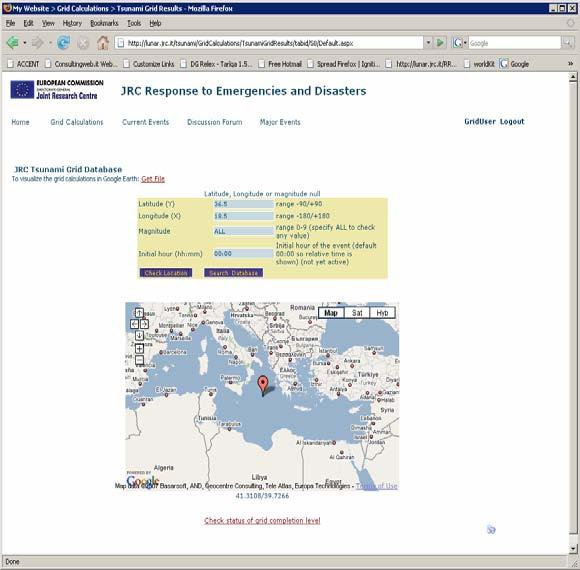
27 Use of the calculation grid Presentation of CRITECH Action November Database browsing Internet web form to specify location and magnitude and getting all calculations close to that point Through Google Earth interface In connection with Early Warning systems it will give an immediate first approximation, in the meantime the real calculation is progressing Every new Tsunami source location should fall inside the grid; if not the grid is enlarged around that new point with a 10x10 additional data points and calculations performed. Access will not be public but restricted to specific organizations


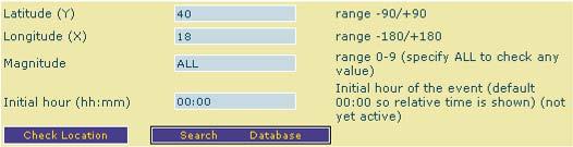
28 Latitude: 40 Longitude: 18 Magnitude: 7 Presentation of CRITECH Action November Manual Search on a web form Latitude: 40 Longitude: 18 Magnitude: 7.25 Latitude: 40 Longitude: 18 Magnitude: 7.5 Latitude: 40 Longitude: 18 Magnitude: 7.75 Latitude: 40 Longitude: 18 Magnitude: 8 Search Database

29 Manual Search on a web form Presentation of CRITECH Action November

30 Analysis with Google Earth Presentation of CRITECH Action November Clicking on a point a preview of the calculation is shown

31 Analysis with Google Earth Presentation of CRITECH Action November Clicking on a point a preview of the calculation is shown

32 Call from Early Warning Systems: GDACS Presentation of CRITECH Action November d 8 h 24 Oct min 22 min Mag. 6.8, Indonesia Several redefinition of the earthquake location


33 Call from Early Warning Systems: GDACS Presentation of CRITECH Action November Oct 2007 Mag. 6.8, Indonesia Lat=-3.83, Lon=100.9, Mag=6.8

34 Call from Early Warning Systems: GDACS Presentation of CRITECH Action November Oct 2007, Indonesia On-line calculation Grid Calculation Lat=-3.83, Lon=100.9, Mag=6.8 Lat=-4, Lon=101, Mag=7 40 min CPU time Immediately available
35 Presentation of CRITECH Action November Tsunami Analysis Tool (TAT)
36 Tsunami Analysis Tool Presentation of CRITECH Action November The analysis of an on-going Tsunami event is a very stressing activity because Need to give an answer on the possible impact of the event as soon as possible Multiple information available from different sources Several signals to check at the same time It is not a routine operation, as it will happen very rarely The objective is the development of an analytical tool that can help the operator in the control room to decide on the possible effects of an event Requirements Access to all on-line and scenario database calculated events, if possible from various models Access to all water level on-line measurements Automatic data Interpretation of water level measurements and comparison with calculated data If enough buoys data are available Determination of the most suitable initial tsunami condition Allows to launch new cases on the execution servers


37 Tsunami Analysis Tool Presentation of CRITECH Action November JRC Tsunami Calculation System Tsunami Analysis Tool GDACS LiveMon PDC Collection & storage server EMSC Execution servers Grid Database (4 TB)

38 Tsunami analysis tool Presentation of CRITECH Action November Clicking the current events the related calculation window is open Buoy location Clicking the buoy locations the current water levels are shown Currently accessing online DART buoys data Current events It can access any tidal sea level for comparison of height at the coast or deep buoys data for wave behaviour
39 Tsunami analysis tool Presentation of CRITECH Action November The analysis of Tsunami online requires an ad-hoc flexible application which easily allows to get online measurements and compare with predicted calculations. Sometimes online data are not immediately available but it is necessary to perform cleaning actions, such as unit conversion, constants addition/subtraction, factor multiplications, drift removal etc Example Peru earthquake 15 aug 2007 magnitude 8 About 200 fatalities Tsunami generated, height about 3 m.

40 Presentation of CRITECH Action November Time of the event Current time Elapsed time from event Online Calculation Grid calculation Buoys water level

41 Original DART data Presentation of CRITECH Action November Station NM West-Southwest of Arica Chile Long term drift Height (mm) (m) Earthquake event Tsunami event Unclear long term decrease /08/ :36 15/08/ :48 16/08/ :00 16/08/ :12 16/08/ :24 16/08/ :36 16/08/ :48 16/08/20 06:00 lat lon Date/Time DART location


42 Impossible a direct comparison Presentation of CRITECH Action November Direct comparison is impossible Original value measured Drift removed with moving average of 50 points
 Comparison is possible, but the measured data needed adjustments")
43 Very good comparison Presentation of CRITECH Action November Measured Calculated 11 min delay (or 97 km) Comparison is possible, but the measured data needed adjustments


44 Presentation of CRITECH Action November km This information is never known at the time of the event!! 158 km 80 km The analysis of the fault form indicates that the epicentre was not in the centre of the fault movement

45 Fault moved 80 km south Presentation of CRITECH Action November Measured Calculated No delay in rising, but slower rise

46 M 7.6 Indonesia 20/2/2008 Presentation of CRITECH Action November Calculated The first epicenter, published by USGS at +18 min, indicated was southern of Simuele Island thus it was creating a wave towards the Indian Ocean The wave height estimated at the buoy location shows an increase of 7 cm, which was not measured.

47 Indonesia 20/2/2008 Presentation of CRITECH Action November The second epicenter, published by USGS at +48 min, indicated a northern location (magnitude lowered to 7.2) The wave height estimated at the buoy location shows a correct behaviour.
48 Presentation of CRITECH Action November The development of the Tsunami Analysis Tool is ongoing. The first version should be completed by the end of Currently all the DART level data plus the Azores island tidal data are automatically downloaded and displayed Access to JRC Tsunami scenario database and online calculations A second version is expected in 2009.

49 Presentation of CRITECH Action November Collaboration with IM, Portugal
50 Collaboration with IM, Portugal Presentation of CRITECH Action November JRC is collaborating with a number of institutions in the field of Tsunami research: Institute of Meteorology, Portugal Ankara University, Turkey (TUBITAK Project) Italian Civil Protection (ongoing discussions) Pacific Disaster Center, USA An important activity with Institute of Meteorology, Portugal has been established in order to support the development of a National Tsunami Early Warning System Project phases PHASE 1 (June-December 2008) Definition of an extended matrix of Tsunami cases Transfer of scenario database to IM Transfer of the LiveMon and the Tsunami Analysis Tool to IM JRC allowed to access IM tide and seismic data Definition of operational parameters for the Tsunami Alerting Device PHASE 2 (January-December 2009) Definition of a better fault model (University of Lisbon and Algarve) Repetition of the scenario calculations with the new model Development and Testing the Tsunami Alerting Device

51 Presentation of CRITECH Action November Historical events * Extension of the matrix *Extension requested by Portugal
52 Conclusions Presentation of CRITECH Action November The Joint Research Centre is strongly committed in supporting the international community in the development of reliable Tsunami EW Systems The system developed by JRC is operational and is extensively used by several international organizations: feedback we have are all positive Important collaboration with some EU member states for implementation of some of the JRC tools JRC is open to collaborate with any other institution in the world
Welcome LESSLOSS Workshop
 Welcome LESSLOSS Workshop Alois J. Sieber acting Director Belgirate 19 July 2007 Page 1 JRC s Mission to provide customer-driven scientific and technical support for the conception, development, implementation
THE TSUNAMI ASSESSMENT MODELLING SYSTEM BY THE JOINT RESEARCH CENTRE
 THE TSUNAMI ASSESSMENT MODELLING SYSTEM BY THE JOINT RESEARCH CENTRE Alessandro Annunziato European Commission Joint Research Centre Via Fermi 1, 21020 Ispra, Italy EMAIL: alessandro.annunziato@jrc.it
Crisis Management and Natural Disasters Overview of JRC operational or pre-operational activities A. Annunziato, D. Al-Khudhairy
 Papagayo, Costarica 3-4 November 2009 Security Science and The Americas 1 Joint Research Centre (JRC) Crisis Management and Natural Disasters Overview of JRC operational or pre-operational activities A.
Tsunami and earthquake in Chile Part 2
 EUROPEAN COMMISSION DIRECTORATE GENERAL JRC JOINT RESEARCH CENTRE Institute for the Protection and Security of the Citizen Global Security and Crisis Management Unit CriTech Sunday, 28 February 2010 Executive
Storm surge modeling at JRC and Data Requirements for the GDACS System A. Annunziato Jan 2015 Deltares, Delft (NL)
") Storm surge modeling at JRC and Data Requirements for the GDACS System A. Annunziato 20-21 Jan 2015 Deltares, Delft (NL) Table of Content Why Storm Surge Modelling? The Joint Research Centre The Global
Storm surge modeling at JRC and Data Requirements for the GDACS System A. Annunziato 20-21 Jan 2015 Deltares, Delft (NL) Table of Content Why Storm Surge Modelling? The Joint Research Centre The Global
SCIENCE OF TSUNAMI HAZARDS
 SCIENCE OF TSUNAMI HAZARDS ISSN 8755-6839 Journal of Tsunami Society International Volume 31 Number 4 2012 RESPONSE OF THE GDACS SYSTEM TO THE TOHOKU EARTHQUAKE AND TSUNAMI OF 11 MARCH 2011 Annunziato,
Storm Surge Modelling at the JRC. A. Annunziato
 Storm Surge Modelling at the JRC A. Annunziato Storm Surge Activities The following modelling activities are carried out at JRC Tsunami wave height forecast Cyclones Storm Surge The activities are performed
Indian Ocean Tsunami Warning System: Example from the 12 th September 2007 Tsunami
 Indian Ocean Tsunami Warning System: Example from the 12 th September 2007 Tsunami Charitha Pattiaratchi 1 Professor of Coastal Oceanography, The University of Western Australia Email: chari.pattiaratchi@uwa.edu.au
Tsunami Chile 27 February 2010
 EUROPEAN COMMISSION DIRECTORATE GENERAL JRC JOINT RESEARCH CENTRE Institute for the Protection and Security of the Citizen Global Security and Crisis Management Unit CriTech Wednesday, 03 March 2010 Tsunami
The JRC Tsunami Assessment Modelling System. A. Annunziato
 The JRC Tsunami Assessment Modelling System A. Annunziato EUR 23063 EN - 2007 2 The Institute for the Protection and Security of the Citizen provides research-based, systemsoriented support to EU policies
Establishment and Operation of a Regional Tsunami Warning Centre
 Establishment and Operation of a Regional Tsunami Warning Centre Dr. Charles McCreery, Director NOAA Richard H. Hagemeyer Pacific Tsunami Warning Center Ewa Beach, Hawaii USA Why A Regional Tsunami Warning
I&CLC2000 in support to new policy initiatives (INSPIRE, GMES,..)
") I&CLC2000 in support to new policy initiatives (INSPIRE, GMES,..) Manfred Grasserbauer, Director Joint Research Centre Institute for Environment and Sustainability 1 IMAGE 2000 European mosaic of satellite
I&CLC2000 in support to new policy initiatives (INSPIRE, GMES,..) Manfred Grasserbauer, Director Joint Research Centre Institute for Environment and Sustainability 1 IMAGE 2000 European mosaic of satellite
The ITSU System in the Pacific Region and Future Upgrades
 The ITSU System in the Pacific Region and Future Upgrades Eddie Bernard Director, Pacific Marine Environmental Laboratory (PMEL) NOAA/USA Pacific Tsunami Warning Center OPERATIONAL ACTIVITIES SEISMIC DATA
Infrastructure for Spatial Information in Europe (INSPIRE) Steve Peedell
 Steve Peedell") Infrastructure for Spatial Information in Europe (INSPIRE) Steve Peedell European Commission DG Joint Research Centre Institute for Environment and Sustainability ESDI Action Overview JRC, European Commission
Infrastructure for Spatial Information in Europe (INSPIRE) Steve Peedell European Commission DG Joint Research Centre Institute for Environment and Sustainability ESDI Action Overview JRC, European Commission
JCOMM-CHy Coastal Inundation Forecasting Demonstration Project (CIFDP)
") WMO World Meteorological Organization Working together in weather, climate and water JCOMM-CHy Coastal Inundation Forecasting Demonstration Project (CIFDP) Coastal Flooding & Vulnerable Populations Coastal
WMO World Meteorological Organization Working together in weather, climate and water JCOMM-CHy Coastal Inundation Forecasting Demonstration Project (CIFDP) Coastal Flooding & Vulnerable Populations Coastal
NUMERICAL SIMULATIONS FOR TSUNAMI FORECASTING AT PADANG CITY USING OFFSHORE TSUNAMI SENSORS
 NUMERICAL SIMULATIONS FOR TSUNAMI FORECASTING AT PADANG CITY USING OFFSHORE TSUNAMI SENSORS Setyoajie Prayoedhie Supervisor: Yushiro FUJII MEE10518 Bunichiro SHIBAZAKI ABSTRACT We conducted numerical simulations
Applied Geoscience and Technology Division SOPAC. Joy Papao, Risk Information Systems Officer
 Joy Papao, Risk Information Systems Officer Secretariat of the Pacific Community SPC 22 Pacific Island States Head office in Noumea, New Caledonia 2 Regional offices (Pohnpei and Honiara) 600 staff 9 Technical
Analysis of a single hot particle by a combination of non-destructive analytical methods
 Int. Symp. on Isotopes in Hydrology, Marine Ecosystems, and Climate Change Studies, 27 03-01 04 2011, Monaco 1 Analysis of a single hot particle by a combination of non-destructive analytical methods http://itu.jrc.ec.europa.eu
SCIENCE OF TSUNAMI HAZARDS
 SCIENCE OF TSUNAMI HAZARDS ISSN 8755-6839 Journal of Tsunami Society International Volume 32 Number 1 2013 THE FRENCH TSUNAMI WARNING CENTER FOR THE MEDITERRANEAN AND NORTHEAST ATLANTIC: CENALT P. Roudil,
7.8M Earthquake in Nepal Situation Report No. 1
 EUROPEAN COMMISSION JOINT RESEARCH CENTRE Institute for the Protection and Security of the Citizen Global Security and Crisis Management Unit Sunday, 26 April 2015 7.8M Earthquake in Nepal Situation Report
Coastal Inundation Forecasting Demonstration Project CIFDP. Flood Forecasting Initiative-Advisory Group (FFI-AG 3), Geneva, 5-7 Dec, 2017
, Geneva, 5-7 Dec, 2017") Coastal Inundation Forecasting Demonstration Project CIFDP Flood Forecasting Initiative-Advisory Group (FFI-AG 3), Geneva, 5-7 Dec, 2017 Coastal Flooding & Vulnerable Populations Coastal populations are
Coastal Inundation Forecasting Demonstration Project CIFDP Flood Forecasting Initiative-Advisory Group (FFI-AG 3), Geneva, 5-7 Dec, 2017 Coastal Flooding & Vulnerable Populations Coastal populations are
Tsunami Response and the Enhance PTWC Alerts
 Tsunami Response and the Enhance PTWC Alerts Ken Gledhill GeoNet Project Director Chair, Intergovernmental Coordination Group, Pacific Tsunami Warning and Mitigation System (PTWS) Overview 1. Procedures
KARI Activation for the International Disasters
 KARI Activation for the International Disasters 5 th Joint Project Team Meeting for Sentinel Asia STEP2 (JPTM2012) 14 th Nov 2012 Boyeol Yoon Senior Researcher, Satellite Information Research Center (SIRC)
Lessons Learned from Past Tsunamis Warning and Emergency Response
 UNESCO IOC CTIC US NOAA ITIC Regional Training Workshop on Strengthening Tsunami Warning and Emergency Response Standard Operating Procedures and the Development of the ICG/CARIBE-EWS PTWC New Enhanced
Improving global coastal inundation forecasting WMO Panel, UR2014, London, 2 July 2014
 Improving global coastal inundation forecasting WMO Panel, UR2014, London, 2 July 2014 Cyclone Sidr, November 2007 Hurricane Katrina, 2005 Prof. Kevin Horsburgh Head of marine physics, UK National Oceanography
Emergency Management Service (EMS) mapping
 mapping") GMES Emergency Management Service (EMS) mapping Frédéric BASTIDE GMES unit, European Commission UN-SPIDER Expert Meeting: "Crowdsource Mapping for Disaster Risk Management and Emergency Response" 3-5 December,
GMES Emergency Management Service (EMS) mapping Frédéric BASTIDE GMES unit, European Commission UN-SPIDER Expert Meeting: "Crowdsource Mapping for Disaster Risk Management and Emergency Response" 3-5 December,
Wainui Beach Management Strategy (WBMS) Summary of Existing Documents. GNS Tsunami Reports
 Summary of Existing Documents. GNS Tsunami Reports") Wainui Beach Management Strategy (WBMS) Summary of Existing Documents GNS Tsunami Reports a) Review of Tsunami Hazard and Risk in New Zealand ( National Risk Report ) b) Review of New Zealand s Preparedness
Wainui Beach Management Strategy (WBMS) Summary of Existing Documents GNS Tsunami Reports a) Review of Tsunami Hazard and Risk in New Zealand ( National Risk Report ) b) Review of New Zealand s Preparedness
GI Technology for Disaster Management
 GI Technology for Disaster Management 17 th ICC on the Regional Space Applications Programme for Sustainable Development (RESAP) 26 th Nov 2013 Bangkok Thailand Period and time of seasonal in thailand
NUMERICAL SIMULATION OF TSUNAMI PROPAGATION AND INUNDATION ALONG THE RAKHINE COAST AREAS IN MYANMAR
 NUMERICAL SIMULATION OF TSUNAMI PROPAGATION AND INUNDATION ALONG THE RAKHINE COAST AREAS IN MYANMAR Su Hninn Htwe Supervisor: Bunichiro SHIBAZAKI MEE12619 Yushiro FUJII ABSTRACT This study aimed to assess
Mainstream Space Technology in Implementing SFDRR - GPSTAR. Srimal Samansiri Disaster Management Centre Government of Sri Lanka
 Mainstream Space Technology in Implementing SFDRR - GPSTAR Srimal Samansiri Disaster Management Centre Government of Sri Lanka SFDRR Priority Actions Effective use of Space technology in SFDRR Priority
Earthquake Hazards. Tsunami
 Earthquake Hazards Tsunami Review: What is an earthquake? Earthquake is the vibration (shaking) and/or displacement of the ground produced by the sudden release of energy. The point inside the Earth where
A PROTOTYPE OF WEB-APPLICATION FOR TSUNAMI DATABASE ALONG SOUTHERN JAVA ISLAND COASTLINE
 A PROTOTYPE OF WEB-APPLICATION FOR TSUNAMI DATABASE ALONG SOUTHERN JAVA ISLAND COASTLINE Ariska Rudyanto MEE07170 Supervisor: Yohei HASEGAWA Yosuke IGARASHI Yushiro FUJII ABSTRACT Development of tsunami
Flood Forecasting. Fredrik Wetterhall European Centre for Medium-Range Weather Forecasts
 Flood Forecasting Fredrik Wetterhall (fredrik.wetterhall@ecmwf.int) European Centre for Medium-Range Weather Forecasts Slide 1 Flooding a global challenge Number of floods Slide 2 Flooding a global challenge
Earthquake Hazards. Tsunami
 Earthquake Hazards Tsunami Measuring Earthquakes Two measurements that describe the power or strength of an earthquake are: Intensity a measure of the degree of earthquake shaking at a given locale based
CLIMATE CHANGE ADAPTATION BY MEANS OF PUBLIC PRIVATE PARTNERSHIP TO ESTABLISH EARLY WARNING SYSTEM
 CLIMATE CHANGE ADAPTATION BY MEANS OF PUBLIC PRIVATE PARTNERSHIP TO ESTABLISH EARLY WARNING SYSTEM By: Dr Mamadou Lamine BAH, National Director Direction Nationale de la Meteorologie (DNM), Guinea President,
Tsunami detection component: discussion about the existing network and real-time data processing. Begoña Pérez Gómez, Puertos del Estado, Spain
 Tsunami detection component: discussion about the existing network and real-time data processing Begoña Pérez Gómez, Puertos del Estado, Spain Outline Marine network: role within TWS s NEAMTWS overview
DATA BASE DEVELOPMENT OF ETA (ESTIMATED TIME OF ARRIVAL) FOR TSUNAMI DISASTER MITIGATION AT SOUTHWESTERN CITIES OF ACEH, INDONESIA
 FOR TSUNAMI DISASTER MITIGATION AT SOUTHWESTERN CITIES OF ACEH, INDONESIA") 6 th South China Sea Tsunami Workshop Nanyang Technology University, Singapore, 6-8 November 2013 DATA BASE DEVELOPMENT OF ETA (ESTIMATED TIME OF ARRIVAL) FOR TSUNAMI DISASTER MITIGATION AT SOUTHWESTERN
6 th South China Sea Tsunami Workshop Nanyang Technology University, Singapore, 6-8 November 2013 DATA BASE DEVELOPMENT OF ETA (ESTIMATED TIME OF ARRIVAL) FOR TSUNAMI DISASTER MITIGATION AT SOUTHWESTERN
Copernicus Overview and Emergency Management Service
 Copernicus Overview and Emergency Management Service Frédéric BASTIDE European Commission Open informal session of the United Nations Inter-Agency Meeting on Outer Space Activities 12 March 2013, Geneva
e-science on Earthquake Disaster Mitigation in Taiwan
 e-science on Earthquake Disaster Mitigation in Taiwan Eric Yen EGI User Forum, April 2011 ~50 earthquakes/day Taiwan Seismicity on Google Earth 0 15 30 70 100 150 km Eurasia Plate S01R Philippine Sea Plate
A Cloud-Based Flood Warning System For Forecasting Impacts to Transportation Infrastructure Systems
 A Cloud-Based Flood Warning System For Forecasting Impacts to Transportation Infrastructure Systems Jon Goodall Associate Professor, Civil and Environmental Engineering Associate Director, Link Lab April
Earthquake Hazards. Tsunami
 Earthquake Hazards Tsunami Review: What is an earthquake? Earthquake is the vibration (shaking) and/or displacement of the ground produced by the sudden release of energy. The point inside the Earth where
Mapping World Events. Clive Best, JRC GI4DM, 2005
 Mapping World Events Clive Best, JRC GI4DM, 2005 Basic Goals Fusion of media reports & Geospatial data for situation and crisis management. Early warning systems & Trend analysis Based on : Automatic Internet
IGOS Geohazards: toward an improved use of Earth Observations for Geohazards mitigation
 IGOS Geohazards: toward an improved use of Earth Observations for Geohazards mitigation Scientific and Technical Subcommittee session Vienna, 15th February 2007 Gonéri Le Cozannet IGOS Geohazards Bureau
Effect of the Emperor seamounts on trans-oceanic propagation of the 2006 Kuril Island earthquake tsunami
 GEOPHYSICAL RESEARCH LETTERS, VOL. 35, L02611, doi:10.1029/2007gl032129, 2008 Effect of the Emperor seamounts on trans-oceanic propagation of the 2006 Kuril Island earthquake tsunami S. Koshimura, 1 Y.
SOP of PTWC as a Regional Tsunami Service Provider
 UNESCO IOC CTIC US NOAA ITIC Regional Training Workshop on Strengthening Tsunami Warning and Emergency Response Standard Operating Procedures and the Development of the ICG/CARIBE-EWS PTWC New Enhanced
WERA Ocean Radar Capability of Real-Time Tsunami Detection
 WERA Ocean Radar Capability of Real-Time Tsunami Detection Dr. Anna Dzvonkovskaya Helzel Messtechnik GmbH Kaltenkirchen, GERMANY e-mail: dzvonkovskaya@helzel.com member of and Worldwide WERA HF Ocean Radar
Three Dimensional Simulations of Tsunami Generation and Propagation
 Chapter 1 Earth Science Three Dimensional Simulations of Tsunami Generation and Propagation Project Representative Takashi Furumura Authors Tatsuhiko Saito Takashi Furumura Earthquake Research Institute,
Advisors: Arcadii Grinshpan, Mathematics and Statistics Rocco Malservisi, School of Geosciences. Problem Suggested By: Rocco Malservisi
 Undergraduate Journal of Mathematical Modeling: One + Two Volume 8 2018 Spring 2018 Issue 2 Article 6 Tsunami Waves Samantha Pennino University of South Florida Advisors: Arcadii Grinshpan, Mathematics
Lessons from the 2004 Sumatra earthquake and the Asian tsunami
 Lessons from the 2004 Sumatra earthquake and the Asian tsunami Kenji Satake National Institute of Advanced Industrial Science and Technology Outline 1. The largest earthquake in the last 40 years 2. Tsunami
TSUNAMI HAZARD ASSESSMENT FOR THE CENTRAL COAST OF PERU USING NUMERICAL SIMULATIONS FOR THE 1974, 1966 AND 1746 EARTHQUAKES
 TSUNAMI HAZARD ASSESSMENT FOR THE CENTRAL COAST OF PERU USING NUMERICAL SIMULATIONS FOR THE 1974, 1966 AND 1746 EARTHQUAKES Sheila Yauri Supervisor: Yushiro FUJII MEE10521 Bunichiro SHIBAZAKI ABSTRACT
A Walk through TRIDEC s intermediate Tsunami Early Warning System
 Collaborative, Complex and Critical Decision-Support in Evolving Crisis A Walk through TRIDEC s intermediate Tsunami Early Warning System M. Hammitzsch, S. Reißland, and M. Lendholt EGU General Assembly,
Global Monitoring for Environment and Security (GMES)
") Global Monitoring for Environment and Security (GMES) Satellite Earth Observation for the Emergency Services Dr Nick Veck Presentation to the G-STEP Launch Univ. of Leicester 19 th June 2009 Contents of
Global Monitoring for Environment and Security (GMES) Satellite Earth Observation for the Emergency Services Dr Nick Veck Presentation to the G-STEP Launch Univ. of Leicester 19 th June 2009 Contents of
TSUNAMI HAZARD ASSESSMENT IN NORTHERN EGYPT USING NUMERICAL SIMULATION
 TSUNAMI HAZARD ASSESSMENT IN NORTHERN EGYPT USING NUMERICAL SIMULATION Abutaleb Ali Supervisor: Bunichiro SHIBAZAKI MEE16717 Yushiro FUJII ABSTRACT To investigate the tsunami hazard along the northern
Tsunami Inundation Modeling in the Aegean Sea
 Tsunami Inundation Modeling in the Aegean Sea B. Aydın Akdeniz University, Antalya, Turkey O. Hoto & U. Kânoğlu Middle East Technical University, Ankara, Turkey SUMMARY: The tsunami forecasting system
Agency Vision and Decision- Maker Needs: A USGS Perspective
 Agency Vision and Decision- Maker Needs: A USGS Perspective Connecting Grassroots to Government for Disaster Management David Applegate USGS Associate Director for Natural Hazards September 13, 2012 U.S.
Geospatial application in Kiribati
 Geospatial application in Kiribati ICC-21 ST RESAP (9 TH TO 13 TH OCTOBER, 2017) BANGKOK, THAILAND Outline Kiribati Profile Natural disasters in Kiribati Achievements Challenges/Issues Ways forward 1 Kiribati
LOG_aLevel. Tsunami Warning System
 LOG_aLevel Tsunami Warning System General Acoustics e.k. Am Kiel-Kanal 1 24106 Kiel Germany Phone: +49 431 5 80 81 80 www.generalacoustics.com Info@generalacoustics.com LOG_aLevel Tsunami Warning System
The benefits and developments in ensemble wind forecasting
 The benefits and developments in ensemble wind forecasting Erik Andersson Slide 1 ECMWF European Centre for Medium-Range Weather Forecasts Slide 1 ECMWF s global forecasting system High resolution forecast
Explore African and Global early warning systems Climate Change effects on water cycle: Flood Risk. Revised website:
 JRC research activities on floods 1 Flood early warning (Europe) EFAS: European Flood Alert System IMPRINTS (DG RTD project): flash flood early warning EU-FLOOD-GIS ETN-R Explore African and Global early
Climate Change Impacts and Adaptation for Coastal Transport Infrastructure in Caribbean SIDS
 UNCTAD National Workshop Jamaica 30 May 1 June 2017, Kingston, Jamaica Climate Change Impacts and Adaptation for Coastal Transport Infrastructure in Caribbean SIDS LISCoAsT Large Scale Integrated Sealevel
Climate Monitoring, Climate Watch Advisory. E. Rodríguez-Camino, AEMET
 Climate Monitoring, Climate Watch Advisory E. Rodríguez-Camino, AEMET WMO International Workshop on Global Review of Regional Climate Outlook Forums, Ecuador, 5 7 September 2017 Outline Introduction. Elements
GIS Support for the Indian Ocean Tsunami Disaster
 GIS Support for the Indian Ocean Tsunami Disaster Lee Schwartz Office of the Geographer and Global Issues Bureau of Intelligence and Research U.S. Department of State Washington, D.C. 20520 Tel: (202)
New Directions in Catastrophe Risk Models
 New Directions in Catastrophe Risk Models World Bank Brown-Bag Lunch Presentation October 9, 2007 Richard J. Murnane Baseline Management Company, Inc. Overview! Background on reinsurance and cat models!
Latitude & Longitude. Worksheets & activities to teach latitude & longitude. Includes notes, activities, review & all answer keys. 11 pages!
 Latitude & Longitude Worksheets & activities to teach latitude & longitude. Includes notes, activities, review & all answer keys. 11 pages! Lines of Latitude & Longitude Name: Lines of latitude and longitude
Earthquake,Tsunami,Volcano Monitoring & Warning System in Korea. Jimin Lee Earthquake & Volcano Monitoring Division KMA
 Earthquake,Tsunami,Volcano Monitoring & Warning System in Korea Jimin Lee Earthquake & Volcano Monitoring Division KMA 1 2 Brief History & Vision of KMA Introduction of Services 3 Korea National Seismographic
(Country Report) [1]
![(Country Report) [1]](/thumbs/95/124397460.jpg "(Country Report) [1]") (Country Report) [1] VANUATU METEOROLOGY AND GEO-HAZARDS DEPARTENT Private Mail Bag 9054 Port Vila Vanuatu (678) 24686 Email: admin@meteo.gov.vu, forecast@meteo.gov.vu Jerry Natugogona (Senior Forecaster)
(Country Report) [1] VANUATU METEOROLOGY AND GEO-HAZARDS DEPARTENT Private Mail Bag 9054 Port Vila Vanuatu (678) 24686 Email: admin@meteo.gov.vu, forecast@meteo.gov.vu Jerry Natugogona (Senior Forecaster)
Project on Seismic Hazard & Vulnerability. areas, Bangladesh. Mohammad Ashraful Kamal (Geologist)
") Project on Seismic Hazard & Vulnerability Assessment in Dhaka, Chittagong & Sylhet city areas, Bangladesh By Mohammad Ashraful Kamal (Geologist) Tectonic & Seismic zoning map of Bangladesh Geological map
Project on Seismic Hazard & Vulnerability Assessment in Dhaka, Chittagong & Sylhet city areas, Bangladesh By Mohammad Ashraful Kamal (Geologist) Tectonic & Seismic zoning map of Bangladesh Geological map
Predicting Tropical Cyclone Formation and Structure Change
 Predicting Tropical Cyclone Formation and Structure Change Patrick A. Harr Department of Meteorology Naval Postgraduate School Monterey, CA 93943-5114 phone: (831)656-3787 fax: (831)656-3061 email: paharr@nps.navy.mil
Enhancing The Delivery Of Weather & Climate Information To End-Users. by Meteorological Services Division, NEA, Singapore
 Enhancing The Delivery Of Weather & Climate Information To End-Users by Meteorological Services Division, NEA, Singapore WMO RA V Seminar on Enhancing Service Delivery Kuala Lumpur, Malaysia, 2-6 April
El Niño 2015/2016 Impact Analysis Monthly Outlook February 2016
 El Niño 2015/2016 Impact Analysis Monthly Outlook February 2016 Linda Hirons, Nicolas Klingaman This report has been produced by University of Reading for Evidence on Demand with the assistance of the
C o p e r n i c u s M a r i n e S e r v i c e i n s u p p o r t t o s u s t a i n a b l e B l u e G r o w t h
 Implemented by C o p e r n i c u s M a r i n e S e r v i c e i n s u p p o r t t o s u s t a i n a b l e B l u e G r o w t h European Commission, DG MARE 19 Januray 2018 C O P E R N I C U S I N B R I E
Magnitude 7.7 QUEEN CHARLOTTE ISLANDS REGION
 A major 7.7 magnitude earthquake struck at 8:04 PM local time in western British Columbia, Canada. The epicenter is located on Moresby Island, the southern large island in the Queen Charlotte Islands region.
C o p e r n i c u s E m e r g e n c y M a n a g e m e n t S e r v i c e f o r e c a s t i n g f l o o d s
 C o p e r n i c u s E m e r g e n c y M a n a g e m e n t S e r v i c e f o r e c a s t i n g f l o o d s Copernicus & Copernicus Services Copernicus EU Copernicus EU Copernicus EU www.copernicus.eu W
EFAS Bulletins. Yearbook Peter Salamon, Jens Bartholmes, Jutta Thielen
 EFAS Bulletins Yearbook 2007 Peter Salamon, Jens Bartholmes, Jutta Thielen EUR 23264 EN - 2008 The mission of the Institute for Environment and Sustainability is to provide scientific-technical support
Citizen Science at the. U.S. Geological Survey
 Citizen Science at the U.S. Geological Survey David Applegate USGS Associate Director for Natural Hazards NRC Board on Earth Science & Resources December 5, 2014 U.S. Department of the Interior U.S. Geological
Funded by Japan Government through UN ESCAP and BMKG
 METEOROLOGY & COAST RADIO SERVICES MINISTRY OF METEOROLOGY, ENERGY, INFORMATION,DISASTER MANAGEMENT, ENVIRONMENT, CLIMATE CHANGE AND COMMUNICATION KINGDOM OF TONGA P. O. Box 845, Domestic Terminal, Fua
GLIDE: Global Unique Disaster Identifier for Effective Sharing of Disaster Information
 2018/SOM1/EPWG/023 Agenda Item: 12.1 GLIDE: Global Unique Disaster Identifier for Effective Sharing of Disaster Information Purpose: Information Submitted by: Japan 13 th Emergency Preparedness Working
History of International Training in Seismology and Earthquake Engineering at IISEE
 History of International Training in Seismology and Earthquake Engineering at IISEE Activities of International Institute of Seismology and Earthquake Engineering (IISEE), BRI - Training for young researchers/engineers
GY 111: Physical Geology
 UNIVERSITY OF SOUTH ALABAMA GY 111: Physical Geology Lecture 31: Mountain Building 1: Isostasy and Thrusting Last Time Earthquakes A) Earthquake intensity and magnitude B) Seismographs C) Case Studies
an accessible interface to marine environmental data Russell Moffitt
 an accessible interface to marine environmental data Russell Moffitt The Atlas Project GOAL: To provide a single point of access to oceanographic and environmental data for use by marine resource researchers,
ShakeAlert Phase 1: West Coast Earthquake Early Warning. Doug Given, USGS EEW Coordinator Education Symposium, Dec. 4, 2018
 ShakeAlert Phase 1: West Coast Earthquake Early Warning Doug Given, USGS EEW Coordinator Education Symposium, Dec. 4, 2018 Population WA 7M OR 4M Annualized Earthquake Losses, $6.1B 61% in California,
Earthquakes and Tsunamis
 Earthquakes and Tsunamis Kenji Satake Earthquake Research Institute University of Tokyo 1 Part I 2011 Tohoku earthquake and tsunami 2 Fukushima Dai ichi NPP accident Earthquake ground motion Reactors automatically
Tsunami Simulation of 2009 Dusky Sound Earthquake in New Zealand
 Tsunami Simulation of 2009 Dusky Sound Earthquake in New Zealand Polina Berezina 1 Institute of Geology, Taras Shevchenko National University of Kyiv, Kyiv, Ukraine Supervisor: Prof. Kenji Satake Earthquake
National Earthquake Monitoring for Tsunami Early Warning. Burin Wechbunthung Sumalee Prachaub Seismological Bureau, Thai Meteorological Department
 National Earthquake Monitoring for Tsunami Early Warning Burin Wechbunthung Sumalee Prachaub Seismological Bureau, Thai Meteorological Department Seismic Sources Out line Historical Earthquake Damage from
Please give me the background details of the warning system the US had before and the new improvements now.
 ----- Original Message ----- From: VADM Conrad C. Lautenbacher Jr., USN (Ret.) To: Announcement@noaa.gov Sent: Friday, January 28, 2005 1:30 PM Subject: Message from the Under Secretary -- NOAA Tsunami
National Survey on the Natural Environment of Japan. Hajime Hirosawa Biodiversity Center of Japan Ministry of the Environment (MOE)
") National Survey on the Natural Environment of Japan Hajime Hirosawa Biodiversity Center of Japan Ministry of the Environment (MOE) Biodiversity Center of Japan, MOE Establishment: 1998 Purpose: to encourage
National Survey on the Natural Environment of Japan Hajime Hirosawa Biodiversity Center of Japan Ministry of the Environment (MOE) Biodiversity Center of Japan, MOE Establishment: 1998 Purpose: to encourage
Indian Ocean Forecast System (INDOFOS) Abhisek Chatterjee
 Abhisek Chatterjee") Indian Ocean Forecast System (INDOFOS) Abhisek Chatterjee Earth System Sciences Organisation (ESSO) Indian National Centre for Ocean Information Services (INCOIS) Ministry of Earth Sciences, Government
Indian Ocean Forecast System (INDOFOS) Abhisek Chatterjee Earth System Sciences Organisation (ESSO) Indian National Centre for Ocean Information Services (INCOIS) Ministry of Earth Sciences, Government
STUDY ON TSUNAMIGENIC EARTHQUAKE CRITERIA FOR THE INDONESIAN TSUNAMI EARLY WARNING SYSTEM
 STUDY ON TSUNAMIGENIC EARTHQUAKE CRITERIA FOR THE INDONESIAN TSUNAMI EARLY WARNING SYSTEM Nanang T. Puspito 1 1 Geophysics Research Group, Faculty of Mining and Petroleum Engineering, Institute of Technology
JRC MARS Bulletin Crop monitoring in Europe January 2016 Weakly hardened winter cereals
 Online version Issued: 25January 2016 r JRC MARS Bulletin Vol. 24 No 1 JRC MARS Bulletin Crop monitoring in Europe January 2016 Weakly hardened winter cereals A first cold spell is likely to have caused
Disaster Risk Management in India. Kamal Kishore New Delhi, 27 October 2016
 Disaster Risk Management in India Kamal Kishore New Delhi, 27 October 2016 Hazard, Exposure and Vulnerability Disaster Prevention Mitigation Hurricane Matthew: Cuba & Haiti Emergency Response Coordination
"Outcomes of the storm surge and waves workshop in Dominican Republic and the questionnaire"
 "Outcomes of the storm surge and waves workshop in Dominican Republic and the questionnaire" Strengthening Regional Cooperation to Support Forecasting with Multi Hazard Approach in RA IV Ritz Carlton Grand
Updating the GEBCO Grid
 Updating the GEBCO Grid PAULINE WEATHERALL, GEBCO DIGITAL ATLAS MANAGER, BRITISH OCEANOGRAPHIC DATA CENTRE (BODC), NATIONAL OCEANOGRAPHY CENTRE (NOC), LIVERPOOL, UK. GEBCO TSCOM and SCRUM meeting, Kuala
Ridracoli Dam: surveillance and safety evaluation reported on internet page
 Ridracoli Dam: surveillance and safety evaluation reported on internet page P.P. MARINI; P. BALDONI; F. FARINA; F. CORTEZZI - Romagna Acque, Forlì, Italy A. MASERA - Enel.Hydro, ISMES Division, Bergamo,
Disclaimer. This report was compiled by an ADRC visiting researcher (VR) from ADRC member countries.
 from ADRC member countries.") Disclaimer This report was compiled by an ADRC visiting researcher (VR) from ADRC member countries. The views expressed in the report do not necessarily reflect the views of the ADRC. The boundaries and
Disclaimer This report was compiled by an ADRC visiting researcher (VR) from ADRC member countries. The views expressed in the report do not necessarily reflect the views of the ADRC. The boundaries and
Low-Latency Earthquake Displacement Fields for Tsunami Early Warning and Rapid Response Support
 Low-Latency Earthquake Displacement Fields for Tsunami Early Warning and Rapid Response Support Hans-Peter Plag, Geoffrey Blewitt Nevada Bureau of Mines and Geology and Seismological Laboratory University
INSPIRE Basics. Vlado Cetl European Commission Joint Research Centre. https://ec.europa.eu/jrc/
 INSPIRE Basics Vlado Cetl European Commission Joint Research Centre https://ec.europa.eu/jrc/ Serving society Stimulating innovation Supporting legislation Outline SDI? Why European SDI? INSPIRE Policy
SUMMARY. Executive Summary: NAVAREA VIII provides the paper of MSI Self Assessment for CPRNW 10
 CPRNW Meeting 10 Agenda Item 3.2.1 CPRNW10/3/2/VIII MSI Self Assessment - NAVAREA VIII Submitted by INDIA SUMMARY Executive Summary: NAVAREA VIII provides the paper of MSI Self Assessment for CPRNW 10
Climate Change Impacts and Adaptation for Coastal Transport Infrastructure in Caribbean SIDS
 UNCTAD National Workshop Saint Lucia 24 26 May 2017, Rodney Bay, Saint Lucia Climate Change Impacts and Adaptation for Coastal Transport Infrastructure in Caribbean SIDS LISCoAsT Large Scale Integrated
Tsunami waveform analyses of the 2006 underthrust and 2007 outer-rise Kurile earthquakes
 Author(s) 2008. This work is licensed under a Creative Commons License. Advances in Geosciences Tsunami waveform analyses of the 2006 underthrust and 2007 outer-rise Kurile earthquakes Y. Tanioka 1, Y.
Disaster Mitigation Competence Centre Project Meeting Coordinator: Simon Lin
 Disaster Mitigation Competence Centre Project Meeting Coordinator: Simon Lin April 26, 2018 Agenda Introduction (Simon Lin) From Previous Meeting on March 17, 2015 (Eric Yen) Progress Report (Eric Yen)