Citizen Science at the. U.S. Geological Survey
|
|
|
- Shona Fitzgerald
- 6 years ago
- Views:
Transcription


1 Citizen Science at the U.S. Geological Survey David Applegate USGS Associate Director for Natural Hazards NRC Board on Earth Science & Resources December 5, 2014 U.S. Department of the Interior U.S. Geological Survey
2 Crowdsourced Data and Social Media: An Infrastructure for Assessing & Monitoring Hazards, Geographic Data, and Ecological Systems Did You Feel It? Did You See It? Is Ash Falling? TED: Tweet Earthquake Dispatch Netquake Sensor Volunteers icoast Did the Coast Change? National Map Corps National Phenology Network


3 Did You Feel It? Rapid & automatic intensity maps based on felt reports submitted online. Users answer simple online questionnaire. Color-code ZIP-code to community s average intensity. Replaces traditional postal questionnaire. M5.8 Virginia Aug, 2011


4 Using DYFI to improve ShakeMap

5 Did You Feel It? comparison: Earthquakes are felt over much larger area in Eastern U.S. Dots represent areas where people reported at least weak shaking M6.0 earthquake Central California Sept. 28, 2004 M5.8 earthquake Central Virginia August 23, 2011

6 10 Years of DYFI Data (~2 million responses) USGS National Seismic Hazard Map (2% in 50 Year Probability of Exceedence)

7 Did You See It? Landslide Reporting Enables crowdsourced, online landslide reports Qualitative information may be used in USGS reports

8 Is Ash Falling? New system collects public ash fall observations and accumulations Users browsing the Alaska Volcano Observatory site during an eruption invited to submit observations. Information received from the public through this tool will help USGS and NWS scientists track eruption clouds, track ash fallout, and refine ash fall modeling efforts

9 Is Ash Falling? Online Interface

10 TED: Tweet Earthquake Dispatch Alerts for earthquakes worldwide with M Magnitude descriptor, location, origin time, link to USGS webpage. Alerts include frequency of tweets in event region that contain the word earthquake or its equivalent in several languages.
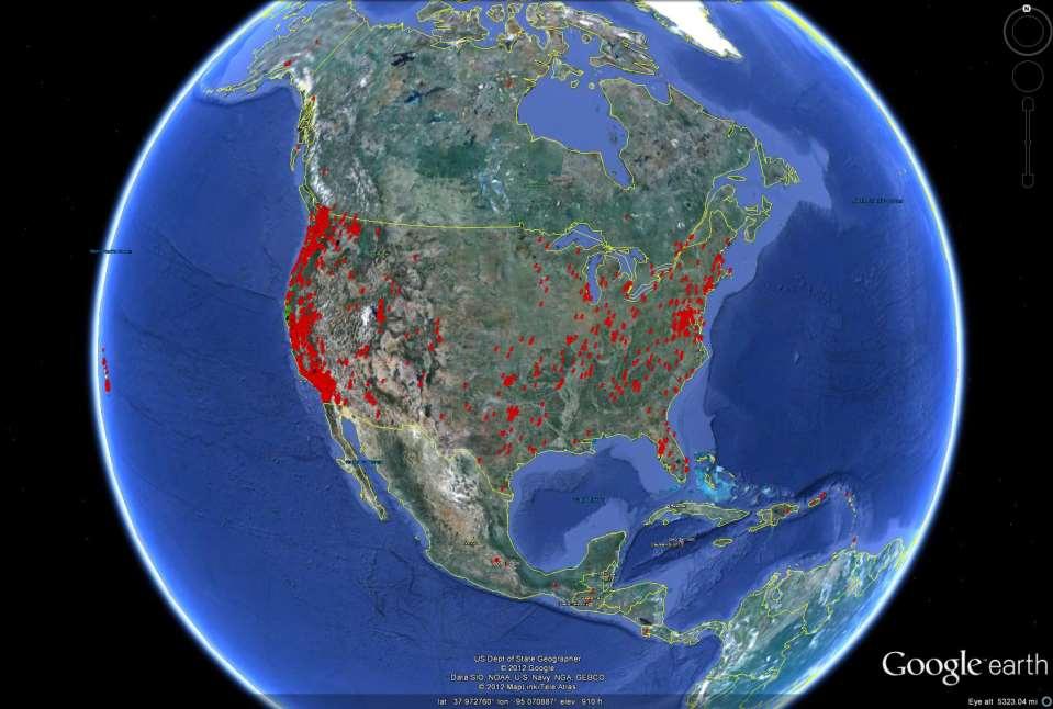
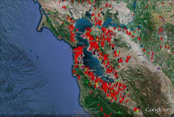
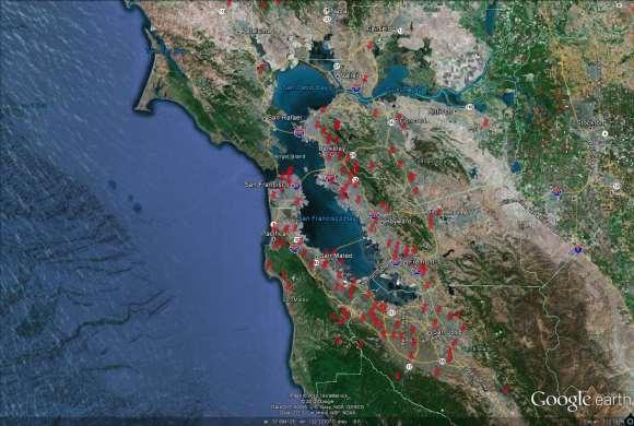
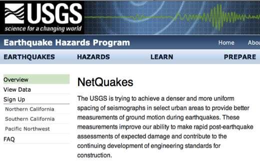
11 NetQuakes volunteers sensor hosts


12 icoast Did the Coast Change? Crowdsourcing to Groundtruth Prediction Models Compare and classify aerial photos of the coast before and after Hurricane Sandy Ground truth and generate coastal change predictions using a Bayesian Network Educate the public about coastal vulnerability from extreme storms coastal.er.usgs.gov/icoast


13 National Map Corps Crowdsourcing used to update USGS geographic data Volunteers mapping structures National program Nearing 2,000 volunteers 100,000 points edited or added since mid-2013 Data become part of The National Map


 Education: train future scientists, improve data quality Remote sensing facilitates scaling from")
14 A critical tool for enabling adaptive responses to climate change Phenology Phenology: the study of seasonal plant and animal life cycle events Is simple to record and understand Integrates biological and physical processes across scales Informs human & ecosystem health, agriculture, recreation Data + models = human adaptation to climate change Nature's Notebook A national monitoring initiative for scientists & citizens Engages agencies, NGOs, academia, public Standard protocols for plants & animals Quality observations from 1000s of observing stations On-line data entry, tools, maps, stories, downloads Provides capacity for other science networks (e.g., NEON) Education: train future scientists, improve data quality Remote sensing facilitates scaling from leaf to globe The Great Sunflower Project Modeled "onset of spring" (2014)
15 USGS is part of widespread Federal interest in citizen science & crowdsourcing White House National Action Plan for Open Government released in 2013 specifically calls for increased crowdsourcing and citizen science programs. An Open Innovation Toolkit is in development for Federal agencies. This will include best practices, training, and policies related to prizes, crowdsourcing, and citizen science. USGS is part of the new Federal Community of Practice on Citizen Science & Crowdsourcing which meets monthly to share lessons learned and develop best practices for designing, implementing, and evaluating crowdsourcing and citizen science initiatives. Currently 27 agencies participate.
16 Further information on USGS citizen science Scientists Need Your Eyes & Ears ntists-need-your-eyes-and-ears/ USGS MyScience website txpub.usgs.gov/myscience/ Any questions?
Agency Vision and Decision- Maker Needs: A USGS Perspective
 Agency Vision and Decision- Maker Needs: A USGS Perspective Connecting Grassroots to Government for Disaster Management David Applegate USGS Associate Director for Natural Hazards September 13, 2012 U.S.
Seismic Recording Station AZ_PFO Summary Report
 Seismic Recording Station AZ_PFO Summary Report Thank you for hosting station AZ_PFO on your property. We hope that you find the enclosed report interesting. Your station is one of the 2000 USArray seismic
The U.S. Geological Survey (USGS) National Earthquake Information Center (NEIC)
 National Earthquake Information Center (NEIC)") The U.S. Geological Survey (USGS) National Earthquake Information Center (NEIC) Gavin Hayes U.S. Geological Survey, National Earthquake Information Center NEIC Mission NEIC - The People 24x7 Operations
The U.S. Geological Survey (USGS) National Earthquake Information Center (NEIC) Gavin Hayes U.S. Geological Survey, National Earthquake Information Center NEIC Mission NEIC - The People 24x7 Operations
Improving Understanding of Drought Impacts through Citizen Science
 Improving Understanding of Drought Impacts through Citizen Science Amanda Brennan, Janae Davis, Kirstin Dow, Kirsten Lackstrom, Sumi Selvaraj North Carolina Water Resources Research Institute Annual Meeting
Geography General Course Year 12. Selected Unit 3 syllabus content for the. Externally set task 2019
 Geography General Course Year 12 Selected Unit 3 syllabus content for the Externally set task 2019 This document is an extract from the Geography General Course Year 12 syllabus, featuring all of the content
Seismic Recording Station TA_109C Summary Report
 Seismic Recording Station TA_109C Summary Report Thank you for hosting station TA_109C on your property. We hope that you find the enclosed report interesting. Your station is one of the 2000 USArray seismic
Season Spotter: Using Citizen Science to Validate and Scale Plant Phenology from Near-Surface Remote Sensing
 Season Spotter: Using Citizen Science to Validate and Scale Plant Phenology from Near-Surface Remote Sensing The Harvard community has made this article openly available. Please share how this access benefits
Florida Friendly Landscapes?
 Florida Friendly Landscapes? Backyards as Habitats Ecology Concepts Ecosystem interacting network of living and non-living components Community association of different species living and interacting in
New NASA Ocean Observations and Coastal Applications
 New NASA Ocean Observations and Coastal Applications Duane Armstrong Chief, Applied Science & Technology Project Office August 20, 2014 1 Outline NASA s new Earth Science Ocean Science Missions for 2014
How to communicate Cascadia Subduction Zone earthquake hazards
 How to communicate Cascadia Subduction Zone earthquake hazards Tom Brocher Research Geophysicist Earthquake Science Center U.S. Geological Survey Menlo Park, California Seattle Post-Intelligencer Lessons
ShakeAlert Earthquake Early Warning
 ShakeAlert Earthquake Early Warning Doug Given USGS, Pasadena Earthquake Program, Early Warning Coordinator 10 seconds 50 seconds 90 seconds USGS Earthquake Hazard Responsibilities USGS has the lead federal
13 June Board on Research Data & Information (BRDI)
") Board on Research Data & Information (BRDI) OUTLINE 2 Challenges of Monitoring Climate Change Recruiting Internet Citizen Scientists Partnering with Citizen Science Alliance Project 1: Data Rescue for
Board on Research Data & Information (BRDI) OUTLINE 2 Challenges of Monitoring Climate Change Recruiting Internet Citizen Scientists Partnering with Citizen Science Alliance Project 1: Data Rescue for
Ellen L. Mecray NOAA Regional Climate Services Director, Eastern Region Taunton, MA
 Ellen L. Mecray NOAA Regional Climate Services Director, Eastern Region Taunton, MA Regions of the US National Climate Assessment What we Observe: Climate changes and impacts Extreme precipitation and
What Can Citizen Scientists Tell Us about Drought?
 What Can Citizen Scientists Tell Us about Drought? Using CoCoRaHS to Improve the Monitoring and Reporting of Drought Impacts Amanda Farris, Kirsten Lackstrom Carolinas Integrated Sciences & Assessments
Module 1, Investigation 3: Predicting Eruptions
 Module 1, Investigation 3: Predicting Eruptions Introduction Welcome! Volcanoes are either "active" or "extinct". Active means that the volcano has erupted during the past 10,000 years. It can also mean
Towards a fully integrated urban weather environment climate service in Mexico City
 Towards a fully integrated urban weather environment climate service in Mexico City Mexico City Ministry of Environment SEDEMA Tanya Müller (Secretary of Environment), Beatriz Cárdenas (SEDEMA), Luisa
United States Multi-Hazard Early Warning System
 United States Multi-Hazard Early Warning System Saving Lives Through Partnership Lynn Maximuk National Weather Service Director, Central Region Kansas City, Missouri America s s Weather Enterprise: Protecting
NESEC NEWS. Published by the Northeast States Emergency Consortium. Wakefield, Massachusetts
 Published by the Northeast States Emergency Consortium Wakefield, Massachusetts Connecticut Maine Massachusetts New Hampshire New Jersey New York Rhode Island Vermont Volume 21 Issue 4 www.nesec.org Winter
A Multi-Agency Approach to Ash-Fall Preparedness and Response in Alaska
 A Multi-Agency Approach to Ash-Fall Preparedness and Response in Alaska Christina Neal Volcanologist U.S. Geological Survey Alaska Volcano Observatory Anchorage, AK Originally Presented November 2012:
What Can Citizen Scientists Tell Us about Drought?
 What Can Citizen Scientists Tell Us about Drought? Amanda Brennan, Kirstin Dow, Benjamin Haywood, Kirsten Lackstrom American Meteorological Society Annual Meeting January 13, 2016 New Orleans, LA Today
Advanced Workshop on Evaluating, Monitoring and Communicating Volcanic and Seismic Hazards in East Africa.
 2053-13 Advanced Workshop on Evaluating, Monitoring and Communicating Volcanic and Seismic Hazards in East Africa 17-28 August 2009 Hazard Communication: Examples From Tanzania, Mozambique, and Cameroon
Geo-information and Disaster Risk Reduction in the Hindu Kush-Himalayan region
 Geo-information and Disaster Risk Reduction in the Hindu Kush-Himalayan region Basanta Shrestha, Division Head MENRIS, International Centre for Integrated Mountain Development Kathmandu, Nepal The International
Monitoring and Warning Systems for Natural Phenomena The Mexican Experience
 Sistema Nacional de Protección Civil Monitoring and Warning Systems for Natural Phenomena The Mexican Experience Roberto Quaas W, Enrique Guevara O. O Mexican National Center for Disaster Prevention CENAPRED
Citizen Science and Arctic Observing: Using the Internet and Simple Technologies to Improve Understanding of Arctic Ecosystem Change
 Citizen Science and Arctic Observing: Using the Internet and Simple Technologies to Improve Understanding of Arctic Ecosystem Change Maribeth S. Murray 1, Phillip A. Loring 2, Howard Ferren 3 and Rebekka
Early Warning > Early Action: The Next Frontier. Dr. Arame Tall Climate Services- Global Coordinator, Champion
 Early Warning > Early Action: The Next Frontier Dr. Arame Tall Climate Services- Global Coordinator, Champion a.tall@cgiar.org 2 3/21/11 The Challenge: Bridging The Gap Seasonal Precipitation Forecast
INDONESIA IMPACT BASED FORECAST PROGRAM
 INDONESIA IMPACT BASED FORECAST PROGRAM Seoul, 19-21 November 2018 The 2nd Regional Workshop on Impact-based Forecasts in Asia Indonesia Agency for Meteorology Climatology and Geophysics (BMKG) A. Fachri
The Kentucky Mesonet: Entering a New Phase
 The Kentucky Mesonet: Entering a New Phase Stuart A. Foster State Climatologist Kentucky Climate Center Western Kentucky University KCJEA Winter Conference Lexington, Kentucky February 9, 2017 Kentucky
Condition Monitoring: A New System for Drought Impacts Reporting through CoCoRaHS
 Condition Monitoring: A New System for Drought Impacts Reporting through CoCoRaHS Amanda Farris Carolinas Integrated Sciences & Assessments (CISA) University of South Carolina WERA 1012 Annual Conference
CLIMATE CHANGE ADAPTATION BY MEANS OF PUBLIC PRIVATE PARTNERSHIP TO ESTABLISH EARLY WARNING SYSTEM
 CLIMATE CHANGE ADAPTATION BY MEANS OF PUBLIC PRIVATE PARTNERSHIP TO ESTABLISH EARLY WARNING SYSTEM By: Dr Mamadou Lamine BAH, National Director Direction Nationale de la Meteorologie (DNM), Guinea President,
Dust Storms in Arizona: The Challenge to Ensure Motorist Safety Jennifer Toth, P.E. Deputy Director for Transportation
 Dust Storms in Arizona: The Challenge to Ensure Motorist Safety Jennifer Toth, P.E. Deputy Director for Transportation Arizona Department of Transportation AASHTO Extreme Weather Event Symposium May 21,
The known requirements for Arctic climate services
 The known requirements for Arctic climate services based on findings described in STT White paper 8/2015 Johanna Ekman / EC PHORS STT Regional drivers The Arctic region is home to almost four million people
USGS National Geospatial Program Understanding User Needs. Dick Vraga National Map Liaison for Federal Agencies July 2015
 + USGS National Geospatial Program Understanding User Needs Dick Vraga National Map Liaison for Federal Agencies July 2015 + Topics 2 Background Communities of Use User Surveys National Map Liaisons Partnerships
Understanding China Census Data with GIS By Shuming Bao and Susan Haynie China Data Center, University of Michigan
 Understanding China Census Data with GIS By Shuming Bao and Susan Haynie China Data Center, University of Michigan The Census data for China provides comprehensive demographic and business information
Nomination Form. Clearinghouse. New York State Office for Technology. Address: State Capitol-ESP, PO Box
 NASIRE 2001 RECOGNITION AWARDS Recognizing Outstanding Achievement in the Field of Innovative Use of Technology Nomination Form Title of Nomination: Manager/Job Title: Agency: NYS Geographic Information
New Madrid and Central U.S. Region Earthquake Hazard
 New Madrid and Central U.S. Region Earthquake Hazard Rob Williams U.S. Geological Survey, Golden, CO March 16, 2017 Reelfoot Lake, TN U.S. Department of the Interior U.S. Geological Survey 1811-12 New
Urban Climate Resilience
 Urban Climate Resilience in Southeast Asia Partnership Project Introduction Planning for climate change is a daunting challenge for governments in the Mekong Region. Limited capacity at the municipal level,
Crowdsourcing, Citizen Science & INSPIRE
 Crowdsourcing, Citizen Science & INSPIRE Muki Haklay & Claire Ellul Extreme Citizen Science (ExCiteS) research group, UCL @mhaklay / @UCL_ExCiteS Outline Three eras of environmental information: By experts,
Tracking Down the Source
 Tracking Down the Source Overview: In this lesson, students use online databases and Google Earth to track down the source of a tsunami. (NOTE: Please teach the GIT Lesson on placemarks prior to this lesson.)
Lesson 8. Natural Disasters
 Lesson 8 Natural Disasters 1 Reading is NOT a spectator sport! 2 Reading requires active participation! 3 PREDICT Try to figure out what information will come next and how the selection might end. 4 Natural
EXPLORE PLATE TECTONICS & MORE THROUGH GPS DATA. Shelley Olds, UNAVCO April 12, 2018 NGSS Webinar
 EXPLORE PLATE TECTONICS & MORE THROUGH GPS DATA Shelley Olds, UNAVCO April 12, 2018 NGSS Webinar Today s Outline Central question: How do we know the tectonic plates are still moving? -- What evidence
The National Integrated Drought Information System in the Midwest
 The National Integrated Drought Information System in the Midwest Advancing Drought Science and Preparedness Across the Nation Ohio River Basin Alliance Summit Thomas More College October 19, 2018 What
Of topic specific knowledge and understanding To encourage progressive development in 'thinking geographically'
 [August 2012] Content exemplars 1. Broad description of the content: Single paragraph, written with technical precision Content rigour (avoiding generic statements) Identifying the core of essential knowledge
12/2/15. Providing observa.ons, data and informa.on products to meet agency and stakeholder needs
 12/2/15 Providing observa.ons, data and informa.on products to meet agency and stakeholder needs 1 Part of the Integrated Ocean Observing System (IOOS) Governed through a Memorandum of Agreement Fiscal
the IRIS Consortium Collaborative, Multi-user Facilities for Research and Education Briefing NSF Business Systems Review September 9, 2008
 the IRIS Consortium Collaborative, Multi-user Facilities for Research and Education Briefing NSF Business Systems Review September 9, 2008 A facilities program for collection and distribution of seismological
Overview. Tools of the Trade. USGS Decision-Making Tools for Pre-Earthquake Mitigation and Post-Earthquake Response
 USGS Decision-Making Tools for Pre-Earthquake Mitigation and Post-Earthquake Response Tools of the Trade DAVID WALD United States Geological Survey NEHRP Workshop: Developing Earthquake Scenarios Sept
WMO Guide on Integrated Urban Weather, Environment and Climate Services for Cities (IUWECS) Hong Kong- an experience from a high-density city
 Hong Kong- an experience from a high-density city") WMO Guide on Integrated Urban Weather, Environment and Climate Services for Cities (IUWECS) Hong Kong- an experience from a high-density city Dr. Chao REN Associate Professor School of Architecture The
WMO Guide on Integrated Urban Weather, Environment and Climate Services for Cities (IUWECS) Hong Kong- an experience from a high-density city Dr. Chao REN Associate Professor School of Architecture The
Spatial Data Availability Energizes Florida s Citizens
 NASCIO 2016 Recognition Awards Nomination Spatial Data Availability Energizes Florida s Citizens State of Florida Agency for State Technology & Department of Environmental Protection Category: ICT Innovations
Physical Geography: Patterns, Processes, and Interactions, Grade 11, University/College Expectations
 Geographic Foundations: Space and Systems SSV.01 explain major theories of the origin and internal structure of the earth; Page 1 SSV.02 demonstrate an understanding of the principal features of the earth
UPTAKE AND PATHWAYS OF COASTAL ADAPTATION PROCESSES IN AUSTRALIA
 2015 Effect of Climate Change on the World's Oceans - Santos, Brazil UPTAKE AND PATHWAYS OF COASTAL ADAPTATION PROCESSES IN AUSTRALIA COASTAL COLLABORATION CLUSTER: MEETING COASTAL CHALLENGES Débora M.
Mapping rainfall and flooding
 Mapping rainfall and flooding BY DAVID WALBERT Although Hurricane Floyd was the biggest storm of 1999 and the one most remembered, eastern North Carolina was hit by three hurricanes in a six-week period
Hurricane Readiness for Coastal Communities
 Hurricane Readiness for Participant Guide Developed for: Federal Emergency Management Agency Emergency Management Institute 16825 South Seton Avenue Emmitsburg, MD 21727-8998 Developed by: C² Technologies,
Reimaging GIS: Geographic Information Society. Clint Brown Linda Beale Mark Harrower Esri
 Reimaging GIS: Geographic Information Society Clint Brown Linda Beale Mark Harrower Esri 8 billion = Number of basemap requests per month on AGOL 14,000 = Unique requests per second 12,000 = New Items
US National Spatial Data Infrastructure A Spatial Framework for Governance and Policy Development to Enable a Location-Based Digital Ecosystem
 GeoPlatform Workshop 7 Dec 2016, Department of the Interior Washington, D.C. US National Spatial Infrastructure A Spatial Framework for Governance and Policy Development to Enable a Location-Based Digital
An Instructional Module. FieldScope Unit 1. Introduction to National Geographic Society s FieldScope Program.
 An Instructional Module FieldScope Unit 1 www.budburst.org/fieldscope Introduction to National Geographic Society s FieldScope Program Unit Contents Overview 3 Learning Objectives Time Commitment Technical
GEO Geohazards Community of Practice
 GEO Geohazards Community of Practice 1) Co-Chair of GHCP With input from: Stuart Marsh, GHCP Co-Chair Francesco Gaetani, GEO Secretariat and many GHCP contributors 1) Nevada Bureau of Mines and Geology
Section 1: The Geosphere
 Section 1: The Geosphere Preview Classroom Catalyst Objectives The Earth as a System Discovering Earth s Interior The Composition of the Earth The Structure of the Earth Plate Tectonics Section 1: The
The Dynamic Earth Section 1. Chapter 3 The Dynamic Earth Section 1: The Geosphere DAY 1
 Chapter 3 The Dynamic Earth Section 1: The Geosphere DAY 1 The Earth as a System The Earth is an integrated system that consists of rock, air, water, and living things that all interact with each other.
The new challenge of community-based environmental monitoring and information systems: the Citizens Obsrevatories Tito Scalo (PZ) 13 July 2016
 13 July 2016") The new challenge of community-based environmental monitoring and information systems: the Citizens Obsrevatories Tito Scalo (PZ) 13 July 2016 Involving citizens in environmental monitoring and awareness:
The new challenge of community-based environmental monitoring and information systems: the Citizens Obsrevatories Tito Scalo (PZ) 13 July 2016 Involving citizens in environmental monitoring and awareness:
Public Disclosure Copy
 Public Disclosure Authorized LATIN AMERICA AND CARIBBEAN Dominica Social, Urban, Rural and Resilience Global Practice Global Practice IBRD/IDA Investment Project Financing FY 2014 Seq No: 7 ARCHIVED on
Twitter s Effectiveness on Blackout Detection during Hurricane Sandy
 Twitter s Effectiveness on Blackout Detection during Hurricane Sandy KJ Lee, Ju-young Shin & Reza Zadeh December, 03. Introduction Hurricane Sandy developed from the Caribbean stroke near Atlantic City,
SOUTHEAST COASTAL ASSESSMENT: Creating a shared vision
 SOUTHEAST COASTAL ASSESSMENT: Creating a shared vision November 12, 2017 Jacqueline Keiser, PG, PMP Regional Sediment Management Regional Center of Expertise SOUTH ATLANTIC DIVISION U.S. ARMY CORPS OF
Village Weather, Snow, Ice, Breakup, Flooding, Fire sites
 Village Weather, Snow, Ice, Breakup, Flooding, Fire sites What is the weather like now in Villages?... 1 BREAKUP:... 2 Flooding... 3 Fires... 5 Weather Predictability, Weather and Ice Advisories and How
HYDRO LO GY O F THE NEW O RL EANS REGIO N
 Your web browser (Safari 7) is out of date. For more security, comfort and the best experience on this site: Update your browser Ignore Activityengage HYDRO LO GY O F THE NEW O RL EANS REGIO N How does
COMMUNITY EMERGENCY RESPONSE TEAM
 COMMUNITY EMERGENCY RESPONSE TEAM INSTRUCTOR GUIDE 40 hour curriculum DEVELOPED FOR: FEDERAL EMERGENCY MANAGEMENT AGENCY EMERGENCY MANAGEMENT INSTITUTE UNITED STATES FIRE ADMINISTRATION DEVELOPED BY: HUMAN
Evidence for plate tectonics
 Evidence for plate tectonics See class powerpoint Printed tables 2x essay Qs markschemes Discuss/Evaluate the evidence for plate tectonics Discuss/evaluate the evidence for plate tectonics Essay: To what
California Reality and Nova Scotia Dreaming. Michael F. Goodchild University of California Santa Barbara
 California Reality and Nova Scotia Dreaming Michael F. Goodchild University of California Santa Barbara 1 The geospatial world Remote sensing Geographic information systems Automated cartography Global
Climate Change and Vegetation Phenology
 Climate Change and Vegetation Phenology Climate Change In the Northeastern US mean annual temperature increased 0.7 C over 30 years (0.26 C per decade) Expected another 2-6 C over next century (Ollinger,
Extreme Temperature Protocol in Middlesex-London
 Clean Air Partnership Webinar March 17, 2009 Extreme Temperature Protocol in Middlesex-London Presented by Iqbal Kalsi, MBA, CPHI(C), CCEP iqbal.kalsi@mlhu.on.ca 1 History Informal monitoring, tracking
Geospatial Data, Services, and Products. National Surveying, mapping and geospatial conference
 Geospatial Data, Services, and Products Federal Programs -- USDA NRCS National Surveying, mapping and geospatial conference March 15, 2016 NRCS Applications using Geosaptial Products & Services Field
Recent forecast operations and outreach activities at the Canadian Hurricane Center (CHC)
") Recent forecast operations and outreach activities at the Canadian Hurricane Center (CHC) Chris Fogarty Canadian Hurricane Center, Halifax, Nova Scotia, Canada Outline CHC our beginnings and current role
Recent forecast operations and outreach activities at the Canadian Hurricane Center (CHC) Chris Fogarty Canadian Hurricane Center, Halifax, Nova Scotia, Canada Outline CHC our beginnings and current role
Coordinated Monitoring of Ash Eruptions in the Russian Far East and Alaska
 Coordinated Monitoring of Ash Eruptions in the Russian Far East and Alaska Dr. John Eichelberger, Program Coordinator, Volcano Hazards Program, US Geological Survey, Reston, Virginia, USA Academician Evgeny
Developing Cross-cultural Education Programs
 Developing Cross-cultural Education Programs Kathy Bertram Director, Education Outreach Office Geophysical Institute University of Alaska Fairbanks Communicating Science in Native Cultures Alaska Native
A Regional Database Tracking Fire Footprint Each Year within the South Atlantic Region: Current Database Description and Future Directions
 A Regional Database Tracking Fire Footprint Each Year within the South Atlantic Region: Current Database Description and Future Directions Last Updated on September 30, 2018 Contributors: NatureServe,
Building earthquake early warning for the west coast. Ken Creager Professor of Earth and Space Sciences University of Washington
 Building earthquake early warning for the west coast Ken Creager Professor of Earth and Space Sciences University of Washington How Earthquake Early Warning works: P-waves S-waves 3-fold way of Earthquake
Introducing the. a partnership of
 Introducing the a partnership of Background Need for online atlas identified by managers and researchers to make coastal data available Shoreline data Ocean and coastal resources Sea-level rise potential
Doug Kluck NOAA Kansas City, MO National Center for Environmental Information (NCEI) National Integrated Drought Information System (NIDIS)
 National Integrated Drought Information System (NIDIS)") National Integrated Drought Information System (NIDIS) for the Missouri River Basin Drought Early Warning Information System (DEWS) & Runoff Trends in the Missouri Basin & Latest Flood Outlook Doug Kluck
National Integrated Drought Information System (NIDIS) for the Missouri River Basin Drought Early Warning Information System (DEWS) & Runoff Trends in the Missouri Basin & Latest Flood Outlook Doug Kluck
National Disaster Management Centre (NDMC) Republic of Maldives. Location
 Republic of Maldives. Location") National Disaster Management Centre (NDMC) Republic of Maldives Location Country Profile 1,190 islands. 198 Inhabited Islands. Total land area 300 sq km Islands range b/w 0.2 5 sq km Population approx.
National Disaster Management Centre (NDMC) Republic of Maldives Location Country Profile 1,190 islands. 198 Inhabited Islands. Total land area 300 sq km Islands range b/w 0.2 5 sq km Population approx.
ShakeAlert Phase 1: West Coast Earthquake Early Warning. Doug Given, USGS EEW Coordinator Education Symposium, Dec. 4, 2018
 ShakeAlert Phase 1: West Coast Earthquake Early Warning Doug Given, USGS EEW Coordinator Education Symposium, Dec. 4, 2018 Population WA 7M OR 4M Annualized Earthquake Losses, $6.1B 61% in California,
Module 1, Investigation 2: Log Sensing volcanic effects from space
 Module 1, Investigation 2: Log Sensing volcanic effects from space Background Volcanoes are extremely disruptive and destructive to the environment and to the people who live nearby. They may disrupt the
Alaska Earthquake Center. By Natalia A. Ruppert Seismic Network Manager
 Alaska Earthquake Center By Natalia A. Ruppert Seismic Network Manager Geophysical Institute, University of Alaska Fairbanks Alaska Earthquake Center mission and historical perspective! Regional seismic
5.2 IDENTIFICATION OF HAZARDS OF CONCERN
 5.2 IDENTIFICATION OF HAZARDS OF CONCERN 2016 HMP Update Changes The 2011 HMP hazard identification was presented in Section 3. For the 2016 HMP update, the hazard identification is presented in subsection
Baldwin County, Alabama
 2015 Baldwin County, Alabama Multi-Hazard Mitigation Plan I. Comprehensive Plan A multi-jurisdiction plan City of Bay Minette City of Daphne Town of Elberta City of Fairhope City of Foley City of Gulf
Enhancing Louisiana s GNIS
 Enhancing Louisiana s GNIS An Outreach Effort Between USGS and the Louisiana Geographic Information Center Louisiana Remote Sensing and GIS Workshop Lafayette, LA April 28, 2010 Louisiana Geographic Information
Explosive volcanic eruptions in the North Pacific: Interactions between the Alaska Volcano Observatory and Volcanic Ash Advisory Centers
 Explosive volcanic eruptions in the North Pacific: Interactions between the Alaska Volcano Observatory and Volcanic Ash Advisory Centers David Schneider U.S. Geological Survey Alaska Volcano Observatory
DEPARTMENT OF GEOLOGY AND MINERAL INDUSTRIES WAYS & MEANS SUBCOMMITTEE ON NATURAL RESOURCES MARCH 2, 2017
 DEPARTMENT OF GEOLOGY AND MINERAL INDUSTRIES WAYS & MEANS SUBCOMMITTEE ON NATURAL RESOURCES MARCH 2, 2017 1 ABOUT DOGAMI AGENCY MISSION, VISION & GOALS 2 Lidar image of a stream network along the Umpqua
Use of Climate information in Disaster Risk Management in Zimbabwe
 Use of Climate information in Disaster Risk Management in Zimbabwe WMO Regional Technical Meeting & User/CONOPS Workshop, 28 th October 2015 Lameck Betera Department of Civil Protection Institutional Arrangements
PROCESSES THAT SHAPE EARTH (4.ES.NGSS)
") TM PROCESSES THAT SHAPE EARTH (4.ES.NGSS) UNIT AT A GLANCE ACTIVITY 1 - Weathering and Erosion Detectives QUESTIONS: How can we make observations and collect data to provide evidence that the surface of
TM PROCESSES THAT SHAPE EARTH (4.ES.NGSS) UNIT AT A GLANCE ACTIVITY 1 - Weathering and Erosion Detectives QUESTIONS: How can we make observations and collect data to provide evidence that the surface of
OCEANOGRAPHIC DATA MANAGEMENT
 OCEANOGRAPHIC DATA MANAGEMENT Presented to: Environmental Disaster Data Management Meeting Russ Beard Director, National Coastal Data Development Center Interim Science Coordinator, Gulf Restoration Council
Archaeology & Digital Humanities
 WAYNE STATE UNIVERSITY Archaeology & Digital Humanities The D.I.R.T. on Big Data STRENGTHENING THE BIG DATA & ANALYTICS ECOSYSTEM WAYNE STATE UNIVERSITY Krysta Ryzewski Associate Professor of Anthropology
5.2 IDENTIFICATION OF HAZARDS OF CONCERN
 5.2 IDENTIFICATION OF HAZARDS OF CONCERN 2015 HMP Update Changes The 2010 HMP hazard identification was presented in Section 6. For the 2015 HMP update, the hazard identification is presented in subsection
Esri and GIS Education
 Esri and GIS Education Organizations Esri Users 1,200 National Government Agencies 11,500 States & Regional Agencies 30,800 Cities & Local Governments 32,000 Businesses 8,500 Utilities 12,600 NGOs 11,000
4.4 MONTHLY WEATHER SUMMARY
 4.4 1 4.4 MONTHLY WEATHER SUMMARY OBJECTIVES The students Collect and summarize monthly weather data about local weather conditions including wind speed and direction, rainfall, temperature, humidity (optional),
USGS Volcano Hazards Program
 USGS Volcano Hazards Program NAS Board on Earth Sciences and Resources May 12, 2014 Charlie Mandeville USGS Program Coordinator cmandeville@usgs.gov www.volcanoes.usgs.gov Volcano Hazards Program Mission:
National Capitol Region HAZUS User Group Call. June 20, :00 AM EST
 National Capitol Region HAZUS User Group Call June 20, 2013 10:00 AM EST NCR HUG Call Details Conference Call Details: 1. Dial-in: 1-267-507-0240 2. Conference code: 697620 Join the Meeting through Adobe
NATURAL HAZARDS MODULE
 NATURAL HAZARDS MODULE Table of Content Vocabulary... 86 Background Infromation... 87 Introduction... 89 Group activity... 90 Worksheets: Oral history... 93 Written history... 95 Mordern planning... 96
The ITSU System in the Pacific Region and Future Upgrades
 The ITSU System in the Pacific Region and Future Upgrades Eddie Bernard Director, Pacific Marine Environmental Laboratory (PMEL) NOAA/USA Pacific Tsunami Warning Center OPERATIONAL ACTIVITIES SEISMIC DATA
M14/3/GEOGR/SP2/ENG/TZ0/XX/Q GEOGRAPHY STANDARD LEVEL PAPER 2. Monday 19 May 2014 (morning) 1 hour 20 minutes INSTRUCTIONS TO CANDIDATES
 1 hour 20 minutes INSTRUCTIONS TO CANDIDATES") M14/3/GEOGR/SP2/ENG/TZ0/XX/Q 22145203 GEOGRAPHY STANDARD LEVEL PAPER 2 Monday 19 May 2014 (morning) 1 hour 20 minutes INSTRUCTIONS TO CANDIDATES Do not open this examination paper until instructed to do
M14/3/GEOGR/SP2/ENG/TZ0/XX/Q 22145203 GEOGRAPHY STANDARD LEVEL PAPER 2 Monday 19 May 2014 (morning) 1 hour 20 minutes INSTRUCTIONS TO CANDIDATES Do not open this examination paper until instructed to do
Hudson River Estuary Climate Change Lesson Project. Grades 5-8 Teacher s Packet. Lesson 2. Observing Changes at Mohonk Preserve
 Grades 5-8 Teacher s Packet Lesson 2 Observing Changes at Mohonk Preserve 2 Observing Changes at Mohonk Preserve NYS Intermediate Level Science Standard 1: Analysis, Inquiry and Design/Scientific Inquiry
A TOOLKIT FOR MARINE SPATIAL PLANNING Version: 17 July, 2009
 A TOOLKIT FOR MARINE SPATIAL PLANNING Version: 17 July, 2009 NEED FOR MARINE SPATIAL PLANNING The health of marine ecosystems is declining, and use conflicts in the marine environment are increasing, in
Crisis Management and Natural Disasters Overview of JRC operational or pre-operational activities A. Annunziato, D. Al-Khudhairy
 Papagayo, Costarica 3-4 November 2009 Security Science and The Americas 1 Joint Research Centre (JRC) Crisis Management and Natural Disasters Overview of JRC operational or pre-operational activities A.