Predicting tsunami waves and currents on the West Coast of Canada: A case study for Ucluelet, BC
|
|
|
- Ella Higgins
- 6 years ago
- Views:
Transcription

1 Predicting tsunami waves and currents on the West Coast of Canada: A case study for Ucluelet, BC Josef Cherniawsky, Kelin Wang and Roy Walters Institute of Ocean Sciences, Fisheries & Oceans Canada Pacific Geosciences Centre, Natural Resources Canada PICES Annual Meeting, Hiroshima, Japan, Oct. 2012
2 Acknowledging: Vasily Titov (PMEL/NOAA): MOST3 tsunami model Michel Breton (CHS/DFO): bathymetry and topography

3 Cascadia subduction zone (CSZ)


4 Deep-sea deposits from megathrust earthquakes yield chronology of these events, which tend to occur every years. The last CSZ was in 1700 CE


5 Tsunami detectives: On January 26, 1700, a tsunami was recorded in Japanese villages along a 1000-km stretch of the Pacific coast

6

7 The 1700 CSZ Earthquake and tsunami (from Satake et al., 2003)
8 Modelling tsunami waves in 3 parts: An earthquake deformation scenario Bathymetry grid construction and editing Computer model design and experiments (Cherniawsky et al., Pure & Applied Geophysics, 2007: CTWL2007)
 medium grid: ~180 m grid size c) fine grid: ~10 m grid size *Titov and Synolakis (1997,")
9 The area of the numerical model * covers most of the CSZ with 3 nested grids: a) coarse grid: ~500 m grid size b) medium grid: ~180 m grid size c) fine grid: ~10 m grid size *Titov and Synolakis (1997, 1998)
. It was used in CTWL2007. Scenario B (Wang and He, BSSA 2008).")
10 Two plausible vertical uplift scenarios for a CSZ earthquake A B Scenario A (Satake et al., JGR 2003; Wang et al., JGR 2003). It was used in CTWL2007. Scenario B (Wang and He, BSSA 2008). It is used in the current study.

11 Scenario A Scenario B
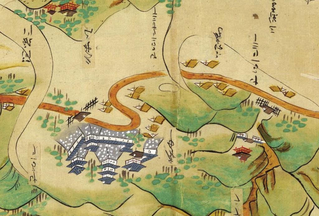
 grid for Ucluelet Inlet from various data sets Sparce")
12 No data! Construction of the fine (~10 m) grid for Ucluelet Inlet from various data sets Sparce data! Data availability: Lidar and NTDB on land, multibeam and single-beam in water
13 Gridded bathymetry A final high-resolution (10-m) grid: Local topography has relatively steep banks and limited low-lying areas where could have significant run-up Numbered symbols mark locations of recorded sealevel time series


14 Model Results: (Scenario B) Wave propagation on a coarse grid Coastal trapped edge waves and leaky modes move along the coast and gradually leak energy into the open ocean

15 Propagation on a medium grid Waves move into Juan de Fuca Strait, Puget Sound and Salish Sea (Strait of Georgia)
16 Sea level time series in some inlets in the medium grid

17 Maximum sea level heights on the coarse grid are near Tofino on the west coast of Vancouver Island (12 hours)

18 Maximum sea level heights on the medium grid are inside Alberni Inlet
")

19 Initial deformation, waves and currents (high-resolution grid) After the earthquake local land and sea bottom drop by more than 2 m
20 Some sea level time series inside the high-resolution grid (stations 5, 6, 7 and 8)

21
22 Maximum sea levels during the 12-hour simulation: Solid line marks the original coastline Inundation is visible in several low-lying areas Largest run-up heights are along the NW coast, where there is little bathymetric data!
23 Maximum current speeds during the 12 hours
24 Maximum heights: Comparison to a different earthquake scenario Scenario A and without run-up (from CTWL2007) Scenario B with run-up
 Scenario B with")
25 Maximum currents Scenario A without run-up (from CTWL2007) Scenario B with run-up
26 Maximum heights: scenario B without and with run-up no run-up with run-up Similar patterns, but without run-up (vertical walls) the maximum is 13.4 m, compared to 7.4 m with run-up

27 Changing the Manning friction coefficient n
28 Preliminary conclusions from CSZ tsunami model experiments as applied to the Ucluelet Inlet area While the timing of the next CSZ earthquake is not known, it will have undoubtedly very serious consequences for the West Coast of North America and, in particular, of Vancouver Island Large tsunami waves (up to 15 m) and currents will flood coastal area and will seriously damage communities and installations The actual maximum run-ups and their locations depend on the initial deformation scenario, while numerical model results are also sensitive to the details of bathymetric and topographic data For this particular model (MOST3), the value of the friction coefficient appears to have a secondary effect on the simulation of run-ups
29 Arougatö
Models of tsunami waves at the Institute of Ocean Sciences
 Models of tsunami waves at the Institute of Ocean Sciences Josef Cherniawsky and Isaac Fine Ocean Science Division, Fisheries & Oceans Canada, Sidney, BC Port Alberni, March 27, 2014 Acknowledgements:
Cascadia Seismic Event Planning for the Maritime Community
 Cascadia Seismic Event Planning for the Maritime Community Jonathan Allan, Oregon Dept. of Geology and Mineral Industries Presentation to Annual Pacific Northwest Waterways Association Meeting (PNWA) October
REPORT TO THE PLANNING, TRANSPORTATION AND PROTECTIVE SERVICES COMMITTEE MEETING OF JUNE 26, 2013
 PPS/PS 2013-07 REPORT TO THE PLANNING, TRANSPORTATION AND PROTECTIVE SERVICES COMMITTEE MEETING OF JUNE 26, 2013 SUBJECT UPDATES TO THE CAPITAL REGIONAL DISTRICT MODELLING OF POTENTIAL TSUNAMI INUNDATION
What scientists know and do not know about the big one at Cascadia
 What scientists know and do not know about the big one at Cascadia Kelin Wang Pacific Geoscience Centre, Geological Survey of Canada Natural Resources Canada The Cascadia Subduction Zone M 7.3, 1946 Rupture
The 1700/01/26 Cascadia subduction zone Earthquake and Tsunami
 Jason R. Patton GEO 142 1/13/15 Abstract: Cascadia subduction zone earthquakes (CSZ) can generate strong ground shaking and deadly tsunamis. Geologists used sediment cores and stream bank exposures to
What is a tsunami? Capital Regional District Tsunami Frequently Asked Questions (FAQ s) Tsunami (soo-nah-mee)
 Tsunami (soo-nah-mee)") Tsunami (soo-nah-mee) Tsunamis (Japanese translation harbour wave ) are waves with a great distance between crests, and are caused by any widespread, sudden movement of large volumes of water. The tsunami
Tsunami (soo-nah-mee) Tsunamis (Japanese translation harbour wave ) are waves with a great distance between crests, and are caused by any widespread, sudden movement of large volumes of water. The tsunami
Tsunami Science Four Years after the 2004 Indian Ocean Tsunami
 Tsunami Science Four Years after the 2004 Indian Ocean Tsunami Part I: Modelling and Hazard Assessment Edited by Phil R. Cummins Laura S. L. Kong Kenji Satake Birkhäuser Basel Boston Berlin Reprint from
Earthquakes, volcanic eruptions, tsunamis (why do we live here?) Tectonic plates. Tectonic plates: Juan de Fuca. Volcanism the past 37 million years
 Tectonic plates. Tectonic plates: Juan de Fuca. Volcanism the past 37 million years") Earthquakes, volcanic eruptions, tsunamis (why do we live here?) Tectonic plates Tectonic plates: Juan de Fuca Volcanism the past 37 million years Tectonic plates: Juan de Fuca Volcanism the past 37 million
Earthquakes, volcanic eruptions, tsunamis (why do we live here?) Tectonic plates Tectonic plates: Juan de Fuca Volcanism the past 37 million years Tectonic plates: Juan de Fuca Volcanism the past 37 million
RECENT COMPREHENSIVE TSUNAMI MODELING FOR COASTAL OREGON
 RECENT COMPREHENSIVE TSUNAMI MODELING FOR COASTAL OREGON Speaker: George R. Priest, Oregon Dept. of Geology and Mineral Industries Pardee Keynote Symposium Great Earthquakes, the Cascadia Subduction Zone,
2. Tsunami Source Details
 2. Tsunami Source Details The Northland area faces a range of potential tsunamigenic sources that include several local and distant fault systems and underwater landslides. A NIWA study (Goff et al. 2006)
Wainui Beach Management Strategy (WBMS) Summary of Existing Documents. GNS Tsunami Reports
 Summary of Existing Documents. GNS Tsunami Reports") Wainui Beach Management Strategy (WBMS) Summary of Existing Documents GNS Tsunami Reports a) Review of Tsunami Hazard and Risk in New Zealand ( National Risk Report ) b) Review of New Zealand s Preparedness
Wainui Beach Management Strategy (WBMS) Summary of Existing Documents GNS Tsunami Reports a) Review of Tsunami Hazard and Risk in New Zealand ( National Risk Report ) b) Review of New Zealand s Preparedness
Effect of the Emperor seamounts on trans-oceanic propagation of the 2006 Kuril Island earthquake tsunami
 GEOPHYSICAL RESEARCH LETTERS, VOL. 35, L02611, doi:10.1029/2007gl032129, 2008 Effect of the Emperor seamounts on trans-oceanic propagation of the 2006 Kuril Island earthquake tsunami S. Koshimura, 1 Y.
The Ocean Floor Earth Science, 13e Chapter 13
 The Ocean Floor Earth Science, 13e Chapter 13 Stanley C. Hatfield Southwestern Illinois College The vast world ocean Earth is often referred to as the blue planet Seventy-one percent of Earth s surface
Riskscape module Documentation: Inundation Modelling in Bay of Plenty. X. Wang C. Mueller
 Riskscape module Documentation: Inundation Modelling in Bay of Plenty X. Wang C. Mueller CONTENTS 1.0 GENERAL INFORMATION... 2 1.1 SITE OF STUDY... 5 1.2 SOURCE SCENARIOS... 5 1.3 NUMERICAL MODEL... 5
Prevention Tsunami wall 10m high (breached by the tsunami due to land level falling by 3m)
") Plate margin Plates Causes Sendai, Japan Convergent plate margin Pacific and Eurasian Plates Convergent plate margin Sima (Pacific plate) moves towards the sial (Eurasian plate) Sima (Pacific plate) is
Plate margin Plates Causes Sendai, Japan Convergent plate margin Pacific and Eurasian Plates Convergent plate margin Sima (Pacific plate) moves towards the sial (Eurasian plate) Sima (Pacific plate) is
TSUNAMI PROPAGATION AND INUNDATION MODELINGS ALONG SOUTH-EAST COAST OF PAPUA NEW GUINEA
 TSUNAMI PROPAGATION AND INUNDATION MODELINGS ALONG SOUTH-EAST COAST OF PAPUA NEW GUINEA Martin WAREK Supervisor: Yushiro FUJII MEE12620 Bunichiro SHIBAZAKI ABSTRACT This study covers tsunami generation,
British Colombia Knight Inlet Strait of Georgia Strait of Juan de Fuca
 An Atlas of Oceanic Internal Solitary Waves (February 2004) Knight Inlet Strait of Georgia Strait of Juan de Fuca Overview Knight Inlet, the Strait of Georgia and the Strait of Juan de Fuca are all shallow
Bathymetry Measures the vertical distance from the ocean surface to mountains, valleys, plains, and other sea floor features
 1 2 3 4 5 6 7 8 9 10 11 CHAPTER 3 Marine Provinces Chapter Overview The study of bathymetry determines ocean depths and ocean floor topography. Echo sounding and satellites are efficient bathymetric tools.
9.3. Earthquakes. Earthquakes at Divergent Boundaries
 9.3 Earthquakes Preview the headings on these two pages. What can you say about where earthquakes occur? As the plates that make up Earth s crust move, the rough edges lock together. Over time, pressure
Mondo Quake in Pacific Northwest? By Leander Kahney
 Introduction to College Reading D Natural Disasters: Earthquake NAME I. Pre-reading. Discuss the following topics with other students at your table. What countries or regions of the world have earthquakes?
NUMERICAL SIMULATION AS GUIDANCE IN MAKING TSUNAMI HAZARD MAP FOR LABUAN ISLAND
 NUMERICAL SIMULATION AS GUIDANCE IN MAKING TSUNAMI HAZARD MAP FOR LABUAN ISLAND MOHD RIDZUAN bin Adam Supervisor: Fumihiko IMAMURA MEE09199 ABSTRACT At the northeast end of the South China Sea, tsunamis
Tsunami Simulation of 2009 Dusky Sound Earthquake in New Zealand
 Tsunami Simulation of 2009 Dusky Sound Earthquake in New Zealand Polina Berezina 1 Institute of Geology, Taras Shevchenko National University of Kyiv, Kyiv, Ukraine Supervisor: Prof. Kenji Satake Earthquake
TSUNAMI INUNDATION MODELING: SENSITIVITY OF VELOCITY AND MOMENTUM FLUX TO BOTTOM FRICTION WITH APPLICATION TO BUILDING DAMAGE AT SEASIDE, OREGON
 TSUNAMI INUNDATION MODELING: SENSITIVITY OF VELOCITY AND MOMENTUM FLUX TO BOTTOM FRICTION WITH APPLICATION TO BUILDING DAMAGE AT SEASIDE, OREGON Hyoungsu Park 1, Dane Wiebe 2, Daniel Cox 3, and Katherine
Chapter Overview. Bathymetry. Measuring Bathymetry. Measuring Bathymetry
 CHAPTER 3 Marine Provinces Chapter Overview The study of bathymetry determines ocean depths and ocean floor topography. Echo sounding and satellites are efficient bathymetric tools. Most ocean floor features
TSUNAMI HAZARD ASSESSMENT IN NORTHERN EGYPT USING NUMERICAL SIMULATION
 TSUNAMI HAZARD ASSESSMENT IN NORTHERN EGYPT USING NUMERICAL SIMULATION Abutaleb Ali Supervisor: Bunichiro SHIBAZAKI MEE16717 Yushiro FUJII ABSTRACT To investigate the tsunami hazard along the northern
Supplement of Scenario-based numerical modelling and the palaeo-historic record of tsunamis in Wallis and Futuna, Southwest Pacific
 Supplement of Nat. Hazards Earth Syst. Sci., 15, 1763 1784, 2015 http://www.nat-hazards-earth-syst-sci.net/15/1763/2015/ doi:10.5194/nhess-15-1763-2015-supplement Author(s) 2015. CC Attribution 3.0 License.
"The Big One" by sea and not by land
 "The Big One" by sea and not by land By Los Angeles Times, adapted by Newsela staff on 03.24.14 Word Count 629 Surfer Lee Johnson emerges from the water at San Onofre State Beach, Calif., with the twin
Map shows 3 main features of ocean floor
 Map shows 3 main features of ocean floor 2017 Pearson Education, Inc. Chapter 3 Marine Provinces 2017 Pearson Education, Inc. 1 Chapter 3 Overview The study of bathymetry determines ocean depths and ocean
NUMERICAL SIMULATIONS FOR TSUNAMI FORECASTING AT PADANG CITY USING OFFSHORE TSUNAMI SENSORS
 NUMERICAL SIMULATIONS FOR TSUNAMI FORECASTING AT PADANG CITY USING OFFSHORE TSUNAMI SENSORS Setyoajie Prayoedhie Supervisor: Yushiro FUJII MEE10518 Bunichiro SHIBAZAKI ABSTRACT We conducted numerical simulations
Resume components. Assignments due Monday. Shape of Puget Sound. Formation and bathymetry
 Assignments due Monday Resume Top four choices of projects, in order of preference One paragraph proposal about topic of choice Weekly schedule Topics you d like to cover in class Math: Complete the calculus
How to communicate Cascadia Subduction Zone earthquake hazards
 How to communicate Cascadia Subduction Zone earthquake hazards Tom Brocher Research Geophysicist Earthquake Science Center U.S. Geological Survey Menlo Park, California Seattle Post-Intelligencer Lessons
Tsunamis and ocean waves
 Department of Mathematics & Statistics AAAS Annual Meeting St. Louis Missouri February 19, 2006 Introduction Tsunami waves are generated relatively often, from various sources Serious tsunamis (serious
4. Regions Northland Region Distant Eastern source: South America (Chile/Peru)
") 4. Regions Maximum water surface elevation images are presented below for tsunamis generated from the sources discussed above; Distant Eastern source: South America (Chile/Peru), Regional Eastern source:
4. Regions Maximum water surface elevation images are presented below for tsunamis generated from the sources discussed above; Distant Eastern source: South America (Chile/Peru), Regional Eastern source:
Inversion of tsunami data. A. Sladen CNRS, Géoazur 1/35
 Inversion of tsunami data A. Sladen CNRS, Géoazur 1/35 DEFINITION Tsunami waves are gravity wave with a long period need a BIG source! 2/35 DEFINITION Krakatoa, 1883 Summer 2015, E.T. pers. comm. Lituya
VALIDATION OF TSUNAMI INUNDATION MODELING FOR THE 2004 SUMATRA-ANDAMAN EARTHQUAKE FOR MAKING HAZARD MAPS IN PENANG AND LANGKAWI, MALAYSIA
 Synopses of Master Papers Bulletin of IISEE, 47, 11-16, 013 VALIDATION OF TSUNAMI INUNDATION MODELING FOR THE 004 SUMATRA-ANDAMAN EARTHQUAKE FOR MAKING HAZARD MAPS IN PENANG AND LANGKAWI, MALAYSIA Noor
Numerical simulations for Investigation of the Coastline Erosion due to the 2004 Indian Ocean Tsunami
 Numerical simulations for Investigation of the Coastline Erosion due to the 2004 Indian Ocean Tsunami Syamsidik, Musa Al ala, Mirza Fahmi, and Tursina Tsunami Computation and Visualization Laboratory Tsunami
Deformation cycles of great subduction earthquakes in a viscoelastic Earth
 Deformation cycles of great subduction earthquakes in a viscoelastic Earth Kelin Wang Pacific Geoscience Centre, Geological Survey of Canada School of Earth and Ocean Science, University of Victoria????
Damage of Sewage Plant by Tsunami
 Damage of Sewage Plant by Tsunami K. Fujima & Y. Shigihara National Defense Acadfemy, Japan SUMMARY: This work describes a damage assessment of a sewage plant in Shizuoka city by next Tokai earthquake
NUMERICAL SIMULATION OF TSUNAMI PROPAGATION AND INUNDATION ALONG THE RAKHINE COAST AREAS IN MYANMAR
 NUMERICAL SIMULATION OF TSUNAMI PROPAGATION AND INUNDATION ALONG THE RAKHINE COAST AREAS IN MYANMAR Su Hninn Htwe Supervisor: Bunichiro SHIBAZAKI MEE12619 Yushiro FUJII ABSTRACT This study aimed to assess
12/07/2013. Apparent sea level rise and earthquakes
 Main collaborations: - P. Simeoni - M. N. Bouin - S. Calmant Valérie Ballu Valerie.ballu@univ-lr.fr Apparent sea level rise and earthquakes possibly the world s first community to be formally moved out
Regional Ocean Climate Model Projections for the British Columbia Continental Shelf
 Regional Ocean Climate Model Projections for the British Columbia Continental Shelf Mike Foreman, Wendy Callendar, John Morrison, Diane Masson, Isaac Fine Institute of Ocean Sciences Fisheries and Oceans
Activity Pacific Northwest Tectonic Block Model
 Activity Pacific Northwest Tectonic Block Model The Cascadia tectonic margin is caught between several tectonic forces, during the relentless motions of the giant Pacific Plate, the smaller subducting
Tsunami Inundation Modeling in the Aegean Sea
 Tsunami Inundation Modeling in the Aegean Sea B. Aydın Akdeniz University, Antalya, Turkey O. Hoto & U. Kânoğlu Middle East Technical University, Ankara, Turkey SUMMARY: The tsunami forecasting system
We have previously looked at artificial seismograms such as this one here.
 We have previously looked at artificial seismograms such as this one here. S P A realistic Seismic Record Each vertical line = 1 minute Each horizontal line = 15 minutes Seismic station PMM is in Parkfield,
TSUNAMI RISK ASSESSMENT MODELLING IN CHABAHAR PORT, IRAN
 TSUNAMI RISK ASSESSMENT MODELLING IN CHABAHAR PORT, IRAN M. R. Delavar a, H. Mohammadi b, *, M. A. Sharifi c, M. D. Pirooz d a Centre of Excellence in Geomatics Eng. in Disaster Management, School of Surveying
Earthquake and Tsunami Modeling in Japan. Renee Lee Product Manager, RMS
 Earthquake and Tsunami Modeling in Japan Renee Lee Product Manager, RMS RMS JAPAN EARTHQUAKE MODEL HISTORY 2011 GREAT EAST JAPAN EARTHQUAKE M9.0 SCOPE OF JAPAN EARTHQUAKE MODEL UPDATE (2012) Event Rate
Tsunami inundation at Crescent City, California generated by earthquakes along the Cascadia Subduction Zone
 GEOPHYSICAL RESEARCH LETTERS, VOL. 34, L20601, doi:10.1029/2007gl030188, 2007 Tsunami inundation at Crescent City, California generated by earthquakes along the Cascadia Subduction Zone Burak Uslu, 1 José
Three Dimensional Simulations of Tsunami Generation and Propagation
 Chapter 1 Earth Science Three Dimensional Simulations of Tsunami Generation and Propagation Project Representative Takashi Furumura Authors Tatsuhiko Saito Takashi Furumura Earthquake Research Institute,
Microplastics in the marine environment of coastal British Columbia
 Microplastics in the marine environment of coastal British Columbia Jean-Pierre Desforges 1, Moira Galbraith 2, Neil Dangerfield 2, Peter Ross 1 1 School of Earth and Ocean Sciences, University of Victoria,
Using deformation rates in Northern Cascadia to constrain time-dependent stress- and slip-rate on the megathrust
 Using deformation rates in Northern Cascadia to constrain time-dependent stress- and slip-rate on the megathrust Lucile Bruhat Paul Segall Stanford University 1 50 Interseismic period for the Cascadia
UNDERSTANDING TSUNAMI RISK TO STRUCTURES: A CANADIAN PERSPECTIVE
 UNDERSTANDING TSUNAMI RISK TO STRUCTURES: A CANADIAN PERSPECTIVE ABSTRACT : D. Palermo 1 and I. Nistor 1 1 Assistant Professor, Dept. of Civil Engineering, University of Ottawa, Ottawa, Canada Email: palermo@eng.uottawa.ca,
Earthquake prediction. Earthquake prediction: animals?
 Earthquake prediction Prediction: specifies that an earthquake of a specific magnitude will occur in a defined region during a particular period: There will be a M 7 or larger earthquake in southern California
Tsunami Hazard Assessment of the Ocosta School Site in Westport, WA
 Tsunami Hazard Assessment of the Ocosta School Site in Westport, WA Final Report: September 11, 2013 Supercedes February 24, 2013 Report Frank González, Randy LeVeque and Loyce Adams University of Washington
UNDERSTANDING TSUNAMI RISK TO STRUCTURES: A CANADIAN PERSPECTIVE
 UNDERSTANDING TSUNAMI RISK TO STRUCTURES: A CANADIAN PERSPECTIVE D. Palermo 1 and I. Nistor 1 1 Assistant Professor, Dept. of Civil Engineering, University of Ottawa, Ottawa, Canada Email: palermo@eng.uottawa.ca,
A Preliminary Tsunami Hazard Assessment of the Canadian Coastline
 GEOLOGICAL SURVEY OF CANADA OPEN FILE 7201 A Preliminary Tsunami Hazard Assessment of the Canadian Coastline L.J. Leonard, G.C. Rogers, and S. Mazzotti 2012 GEOLOGICAL SURVEY OF CANADA OPEN FILE 7201 A
Foundations of Earth Science, 6e Lutgens, Tarbuck, & Tasa
 Foundations of Earth Science, 6e Lutgens, Tarbuck, & Tasa Oceans: The Last Frontier Foundations, 6e - Chapter 9 Stan Hatfield Southwestern Illinois College The vast world ocean Earth is often referred
This article is provided courtesy of the American Museum of Natural History.
 Avoiding Earthquake Surprises in the Pacific Northwest This article is provided courtesy of the American Museum of Natural History. How Vulnerable Is the Pacific Northwest? Cascadia is a region in the
Lecture Outlines PowerPoint. Chapter 13 Earth Science 11e Tarbuck/Lutgens
 Lecture Outlines PowerPoint Chapter 13 Earth Science 11e Tarbuck/Lutgens 2006 Pearson Prentice Hall This work is protected by United States copyright laws and is provided solely for the use of instructors
Direct energy estimation of the 2011 Japan tsunami using deep-ocean pressure measurements
 JOURNAL OF GEOPHYSICAL RESEARCH, VOL. 117,, doi:10.1029/2011jc007635, 2012 Direct energy estimation of the 2011 Japan tsunami using deep-ocean pressure measurements Liujuan Tang, 1,2 Vasily V. Titov, 2
B.C. s Offshore Oil and Gas: a Guide to the Geology and Resources.
 B.C. s Offshore Oil and Gas: a Guide to the Geology and Resources. Introduction Beneath the offshore regions of British Columbia are four moderately large, geologically young sedimentary basins (Figure
SMR/ May Simulation Analyses of Tsunami caused by Chilean and Nihon-Kai Chubu Earthquakes at Nuclear Power Plant Sites in Japan
 SMR/1839-2 Workshop on the Physics of Tsunami, Hazard Assessment Methods and Disaster Risk Management (Theories and Practices for Implementing Proactive Countermeasures) 14-18 May 2007 Simulation Analyses
crustal structure experiment beneath Wairarapa - Wellington area: results from SAHKE
 crustal structure experiment beneath Wairarapa - Wellington area: results from SAHKE Tim Stern and SAHKE team* * VUW, GNS, University of Southern California, University of Tokyo(Japan) SAHKE = Seismic
Probabilistic Tsunami Hazard Analysis
 Probabilistic Tsunami Hazard Analysis H.K. Thio & P.G. Somerville URS Corp, Los Angeles, CA, USA J. Polet California State Polytechnic University, CA, USA SUMMARY: The large tsunami disasters of the last
SIMULATION OF A WORST CASE TSUNAMI SCENARIO FROM THE MANILA TRENCH TO VIETNAM
 SIMULATION OF A WORST CASE TSUNAMI SCENARIO FROM THE MANILA TRENCH TO VIETNAM Nguyen Hong Phuong, Vu Ha Phuong, Pham The Truyen Earthquake Information and Tsunami Warning Centre, VAST OUTLINE Earthquake
Modelling of Potential Tsunami Inundation Limits and Run-Up
 Water Capital Regional District Modelling of Potential Tsunami Prepared by: AECOM 200 415 Gorge Road East 250 475 6355 tel Victoria, BC, Canada V8T 2W1 250 475 6388 fax www.aecom.com Project Number: 60242933
REAL-TIME TSUNAMI INUNDATION FORECAST STUDY IN CHIMBOTE CITY, PERU
 REAL-TIME TSUNAMI INUNDATION FORECAST STUDY IN CHIMBOTE CITY, PERU Nabilt Moggiano Supervisor: Kenji SATAKE MEE16720 ABSTRACT For rapid forecast of tsunami inundation during a tsunamigenic event, we constructed
The Bottom of the Ocean
 The Bottom of the Ocean Overview: In this lesson, students study bathymetric features of the ocean, predict how bathymetric features influence propagation and runup, then analyze an animation of a tsunami
TSUNAMI and SEICHE DEFINITIONS:
 TSUNAMI and SEICHE DEFINITIONS: Seiche A series of standing waves (sloshing action) of an enclosed body or partially enclosed body of water caused by earthquake shaking. Seiche action can affect harbors,
EMERGENCY PLANNING IN NORTHERN ALGERIA BASED ON REMOTE SENSING DATA IN RESPECT TO TSUNAMI HAZARD PREPAREDNESS
 EMERGENCY PLANNING IN NORTHERN ALGERIA BASED ON REMOTE SENSING DATA IN RESPECT TO TSUNAMI HAZARD PREPAREDNESS Barbara Theilen-Willige Technical University of Berlin, Institute of Applied Geosciences Department
Ocean circulation, sedimentation in the San Juans - compilation of mainstream scientific literature by Dave Hyde -
 Ocean circulation, sedimentation in the San Juans - compilation of mainstream scientific literature by Dave Hyde - Salish Sea has 3 principal estuaries SG, JDF,PS San Juan Islands ocean setting uniquely
MAR110 LECTURE #6 Volcanoes I
 1 MAR110 LECTURE #6 Volcanoes I Ocean Basin Volcanism Mid-ocean ridge volcanism produces ocean crust and occasional volcanic islands which when underwater are called seamounts. Isolated hotspots produce
Earthquake Source. Kazuki Koketsu. Special Session: Great East Japan (Tohoku) Earthquake. Earthquake Research Institute, University of Tokyo
 Earthquake. Earthquake Research Institute, University of Tokyo") 2012/9/24 17:20-17:35 WCEE SS24.4 Special Session: Great East Japan (Tohoku) Earthquake Earthquake Source Kazuki Koketsu Earthquake Research Institute, University of Tokyo 1 Names and features of the earthquake
2012/9/24 17:20-17:35 WCEE SS24.4 Special Session: Great East Japan (Tohoku) Earthquake Earthquake Source Kazuki Koketsu Earthquake Research Institute, University of Tokyo 1 Names and features of the earthquake
On the open sea propagation of 2004 global tsunami generated by the sea bed deformation
 On the open sea propagation of 00 global tsunami generated by the sea bed deformation Md. Fazlul Karim Principal Lecturer, Engineering Mathematics Unit, Faculty of Engineering, Universiti Teknologi Brunei,
Annual Report for Research Work in the fiscal year 2005
 JST Basic Research Programs C R E S T (Core Research for Evolutional Science and Technology) Annual Report for Research Work in the fiscal year 2005 Research Area : High Performance Computing for Multi-scale
Numerical Modeling for the Propagation of Tsunami Wave and Corresponding Inundation
 IOSR Journal of Mechanical and Civil Engineering (IOSR-JMCE) e-issn: 78-1684,p-ISSN: 30-334X, Volume 1, Issue Ver. IV (Mar - Apr. 015), PP 55-6 www.iosrjournals.org Numerical Modeling for the Propagation
Modeling of the 2011 Tohoku-oki. oki Tsunami and it s s impacts to Hawaii
 WAVES 11, KONA HAWAI`I Modeling of the 2011 Tohoku-oki oki Tsunami and it s s impacts to Hawaii Yoshiki Yamazaki 1, Volker Roeber 1, Kwok Fai Cheung 1 and Thorne Lay 2 1 Department of Ocean and Resources
Preparation for Future Earthquake and Tsunami Hazards: Lessons Learned from the 2004 Sumatra-Andaman Earthquake and the Asian Tsunami
 First International Conference of Aceh and Indian Ocean Studies Organized by Asia Research Institute, National University of Singapore & Rehabilitation and Construction Executing Agency for Aceh and Nias
AIRBORNE LIDAR BATHYMETRY By the Japan Hydrographic and Oceanographic Department
 AIRBORNE LIDAR BATHYMETRY By the Japan Hydrographic and Oceanographic Department H. OGAWA, K. OYAKAWA, K. KAWAI, H. OZAWA, H. YAJIMA, H. SHIRANE, H. YAMANO, N. HIRATA, N. IWAMOTO, T. ONO, S. TOMIZAWA,
Dr. ELIAS A., International Day for Disaster Risk Reduction, AUB - 15 Oct 2012
 3/3/14 Dr. Ata ELIAS, Geology department AUB Outline 1. Tsunami events: 2. The physical and geological tsunami event 3. Global tsunami mitigation efforts Tsunami hazard 1. The tsunami hazard in the Mediterranean
Updating the GEBCO Grid
 Updating the GEBCO Grid PAULINE WEATHERALL, GEBCO DIGITAL ATLAS MANAGER, BRITISH OCEANOGRAPHIC DATA CENTRE (BODC), NATIONAL OCEANOGRAPHY CENTRE (NOC), LIVERPOOL, UK. GEBCO TSCOM and SCRUM meeting, Kuala
Numerical Tsunami Propagation of 1703 Kanto Earthquake
 Numerical Tsunami Propagation of 1703 Kanto Earthquake Wu Yifei Supervisor: Kenji Satake Introduction Near Tokyo Bay, the 1703 Genroku Kanto Earthquake is known to generate a tsunami which hit the nearby
BIBLIOGRAPHIC REFERENCE
 BIBLIOGRAPHIC REFERENCE Power, W. L.; Wang, X.; Barberopoulou, A.; Mueller, C. 2014. Validation of a deaggregation-based approach for tsunami evacuation mapping, GNS Science Report 2014/36. 56 p. W. L.
STUDENT NAME: STUDENT NUMBER: Faculty of Science FINAL EXAMINATION ATMOSPHERIC & OCEANIC SCIENCES ATOC 185 EARTH & PLANETARY SCIENCES EPSC 185
 STUDENT NAME: STUDENT NUMBER: Faculty of Science FINAL EXAMINATION ATMOSPHERIC & OCEANIC SCIENCES ATOC 185 EARTH & PLANETARY SCIENCES EPSC 185 NATURAL DISASTERS Examiners: Professor J. Gyakum and Professor
Chapter 9 Lecture Outline. Oceans: The Last Frontier
 Chapter 9 Lecture Outline Oceans: The Last Frontier The Vast World Ocean Earth is referred to as the blue planet 71% of Earth s surface is oceans and marginal seas Continents and islands comprise the remaining
Earthquakes and Tsunamis
 Earthquakes and Tsunamis Kenji Satake Earthquake Research Institute University of Tokyo 1 Part I 2011 Tohoku earthquake and tsunami 2 Fukushima Dai ichi NPP accident Earthquake ground motion Reactors automatically
discussion of North America s physical features, including its landforms and bodies of
 Chapter 7 Natural Environments of North America Chapter 7 focuses on the natural environments of North America. The chapter opens with a discussion of North America s physical features, including its landforms
REAL-TIME TSUNAMI INUNDATION PREDICTION USING OFFSHORE TSUNAMI OBSERVATION. Daisuke TATSUMI 1 and Takashi TOMITA 1
 REAL-TIME TSUNAMI INUNDATION PREDICTION USING OFFSHORE TSUNAMI OBSERVATION Daisuke TATSUMI and Takashi TOMITA The previous real-time tsunami prediction based on the inversion method and the linear superposition
Modeling the Transport and Fate of Sediments Released from Dredging Projects in the Coastal Waters of British Columbia, Canada
 WEDA Dredging Summit & Expo 18 Modeling the Transport and Fate of Sediments Released from Dredging Projects in the Coastal Waters of British Columbia, Canada David B. Fissel, Yuehua (Andy) Lin and Todd
Prediction of changes in tidal system and deltas at Nakdong estuary due to construction of Busan new port
 Prediction of changes in tidal system and deltas at Nakdong estuary due to construction of Busan new port H. Gm1 & G.-Y. park2 l Department of Civil & Environmental Engineering, Kookmin University, Korea
Magnitude 6.5 OFFSHORE NORTHERN CALIFORNIA
 A powerful offshore earthquake that struck near the Northern California coast left a hodgepodge of debris for communities to sort through Sunday but spared residents any serious injury. After 25,000 people
Three Fs of earthquakes: forces, faults, and friction. Slow accumulation and rapid release of elastic energy.
 Earthquake Machine Stick-slip: Elastic Rebound Theory Jerky motions on faults produce EQs Three Fs of earthquakes: forces, faults, and friction. Slow accumulation and rapid release of elastic energy. Three
(energy loss is greater with longer wavelengths)
") GEOL 0820 Ramsey Natural Disasters Spring, 2018 LECTURE #9: Tsunami Monitoring & Mitigation Date: 8 February 2018 I. Characteristics (con t): shoaling: o process of wave height increase and breaking as
GEOL 0820 Ramsey Natural Disasters Spring, 2018 LECTURE #9: Tsunami Monitoring & Mitigation Date: 8 February 2018 I. Characteristics (con t): shoaling: o process of wave height increase and breaking as
Introduction to Environmental Geology, 5e Case History: Indonesian Tsunami Indonesian Tsunami (2) Introduction Historic Tsunamis
 Introduction Historic Tsunamis") 1 2 3 4 5 6 7 8 9 Introduction to Environmental Geology, 5e Chapter 7 Tsunami Case History: Indonesian Tsunami December 26, 2004, within a few hours, close to 250,000 people were killed With no warning
1 2 3 4 5 6 7 8 9 Introduction to Environmental Geology, 5e Chapter 7 Tsunami Case History: Indonesian Tsunami December 26, 2004, within a few hours, close to 250,000 people were killed With no warning
TSUNAMI and SEICHE DEFINITIONS:
 TSUNAMI and SEICHE DEFINITIONS: Seiche The action of a series of standing waves (sloshing action) of an enclosed body or partially enclosed body of water caused by earthquake shaking. Seiche action can
A GLOBAL SURGE OF GREAT EARTHQUAKES FROM AND IMPLICATIONS FOR CASCADIA. Thorne Lay, University of California Santa Cruz
 A GLOBAL SURGE OF GREAT EARTHQUAKES FROM 2004-2014 AND IMPLICATIONS FOR CASCADIA Thorne Lay, University of California Santa Cruz Last 10 yrs - 18 great earthquakes: rate 1.8/yr; rate over preceding century
Cascadia megathrust earthquakes: reducing risk through science, engineering, and planning
 Cascadia megathrust earthquakes: reducing risk through science, engineering, and planning NSF Hazards SEES EAR-1331412 Urban Science and Engineering Workshop 21 July 2014 Everything to do with M9 Cascadia
QUANTIFYING NUMERICAL MODEL ACCURACY AND VARIABILITY. Luis Montoya 1 and Patrick Lynett 1
 QUANTIFYING NUMERICAL MODEL ACCURACY AND VARIABILITY Luis Montoya 1 and Patrick Lynett 1 On March 11, 2011 the Tohoku tsunami event caused the death of thousands of people and generated billions of dollars
NOAA TIME Eastern Strait of Juan de Fuca, Washington, Mapping Project: Procedures, Data Sources, and Products
 NOAA Technical Memorandum OAR PMEL NOAA TIME Eastern Strait of Juan de Fuca, Washington, Mapping Project: Procedures, Data Sources, and Products Angie J. Venturato 1, Vasily V. Titov 1, Harold Mofjeld
Sendai Earthquake NE Japan March 11, Some explanatory slides Bob Stern, Dave Scholl, others updated March
 Sendai Earthquake NE Japan March 11, 2011 Some explanatory slides Bob Stern, Dave Scholl, others updated March 14 2011 Earth has 11 large plates and many more smaller ones. Plates are 100-200 km thick
Differentiating earthquake tsunamis from other sources; how do we tell the difference?
 Differentiating earthquake tsunamis from other sources; how do we tell the difference? David Tappin (1), Stephan Grilli (2), Jeffrey Harris (2), Timothy Masterlark (3), James Kirby (4), Fengyan Shi Shi