RECENT COMPREHENSIVE TSUNAMI MODELING FOR COASTAL OREGON
|
|
|
- Jeremy Boone
- 6 years ago
- Views:
Transcription

1 RECENT COMPREHENSIVE TSUNAMI MODELING FOR COASTAL OREGON Speaker: George R. Priest, Oregon Dept. of Geology and Mineral Industries Pardee Keynote Symposium Great Earthquakes, the Cascadia Subduction Zone, and Society II (GSA Session No. 237) Tuesday, 21 October /28/2014 GSA, Vancouver, BC,


2 The Scientific Team Rob Witter Joseph Zhang Chris Goldfinger George Priest Kelin Wang
3 Overview of Tsunami Modeling GUIDING PHILOSOPHY: Most serious threat = local Cascadia subduction zone (CSZ) tsunamis THUS with limited resources we: 1. Limited distant tsunami scenarios to maximum considered historical and hypothetical events. 2. Limited local CSZ scenarios to best deterministic representation of the 10,000-yr paleoseismic record. 3. Used a static tide at MHHW (mean higher high water). 4. Used the finite element model SELFE with unstructured grids: Highly efficient, parallel processing Simulates very small features such as jetties without multiple, nested grids 5. Tested CSZ sources for compatibility to data from: Paleotsunami deposits Paleosubsidence
 3. Deep megathrust rupture (ends at Pleistocene wedge) Fault geometry of McCrory et al.")
 A McCrory et al.")
4 CSZ Fault Models 1. Megathrust rupture (whole SZ) 2. Splay fault rupture (at Pleis.-Plioc. contact) 3. Deep megathrust rupture (ends at Pleistocene wedge) Fault geometry of McCrory et al. (2004) Okada (1985) point source model Dynamic coulomb wedge theory (Wang and Hu, 2006) Sumatra Earthquake A Chlieh and others (2007) A McCrory et al. (2004) GSA, Vancouver, BC, /28/2014
 Cape")
5 Fault Model Splay fault rupture Imaged in seismic lines offshore 30 dip; merges with megathrust Slip is partitioned to splay fault Mann and Snavely (1984) Cape Blanco


6 Fault Model Deep megathrust rupture Deep buried rupture Coseismic slip limited to inner, Tertiary wedge Outer wedge poorly coupled Adam et al., 2004
 Tsunami deposits in an Oregon bog (Ecola Creek marsh, Cannon Beach) Cannon Beach")
7 Use paleoseismology as the foundation for tsunami modeling 10,000-yr record of deep sea turbidites Coastal evidence of coseismic subsidence and tsunami inundation Tsunami deposits in an Oregon coastal lake (Bradley Lake) Tsunami deposits in an Oregon bog (Ecola Creek marsh, Cannon Beach) Cannon Beach (Bradley Lake)


8 Assumptions for CSZ logic tree: Full-margin ruptures efficiently depict the tsunami hazard (e.g., Priest et al., 2014) Peak slip deficits times between full-margin (sand) turbidites x convergence rate. Partial ruptures (mud turbidites) decrease slip deficit available to full-margin sources. 10/28/2014 Picture at top is from Chris Goldfinger; illustrations are from or modified from Goldfinger et al. (2012). GSA, Vancouver, BC,

9 Scaled Turbidite Mass Full-Margin Turbidite Mass vs Age 31 PC Rogue Canyon 23 PC Cascadia Channel Central OR 12 PC Cascadia Channel WA Modified from Goldfinger et al. (2012) ,000 9,000 10/28/2014 8,000 7,000 6,000 5,000 4,000 3,000 Years Before AD 1950 GSA, Vancouver, BC, ,000 1,
 Mass binning (colors) + slip deficit times assigned to T-shirt scenarios Slip Deficit Time (turbidite follow")
10 Comparison of binning: Numbers (of 19) full-margin Cascadia turbidites binned by slip deficit (follow) times versus mass (Witter et al., 2011; 2013) Mass binning (colors) + slip deficit times assigned to T-shirt scenarios Slip Deficit Time (turbidite follow times)
11 Minimum peak CSZ slip needed to account for coastal paleotsunami deposits at Bradley Lake and Cannon Beach: 8-15 m Peak Slip Illustration from Wang and He (2007)

12 CANNON BEACH PALEOTSUNAMI EXPERIMENT Simulated tsunami inundations on1000-yrold paleo-landscapes compared to cored tsunami deposits. Figure from Priest et al. (2009)
13 Cannon Beach Experiment RESULTS Minimum peak fault slip = ~ 14 m (splay fault) 15 m (no splay fault) to inundate past the last 3 Cascadia tsunami deposits

14 Bradley Lake Experiment Validate tsunami simulations against 4600 yrs of CSZ tsunami deposits in Bradley Lake Simulate the LEAST tsunamis Experimental variables: Landscape Sea level Earthquake source ~6-m barrier Bradley Lake 1 km
 Seacliff topography (most landward shoreline) A B C")
15 2009 lidar topography with straightened channel 1700 topography simulated by 1925 shoreline (no 2009 foredunes) Seacliff topography (most landward shoreline) A B C
 For most landward shoreline (smallest tsunami able to reach lake): Minimum peak fault slip = ~8 (splay) to 9 m (no splay) (Witter et al.")
 Mean recurrence of turbidites directly offshore = 300-380 yrs (Priest et al.")
16 Bradley Lake Experiment RESULTS For AD 1700 shoreline (contemporaneous with an average turbidite): Minimum peak fault slip = ~12 (splay) to 13 m (no splay) (Witter et al., 2012) For most landward shoreline (smallest tsunami able to reach lake): Minimum peak fault slip = ~8 (splay) to 9 m (no splay) (Witter et al., 2012) Mean recurrence of Bradley Lake tsunami sands = yrs in last 4,600 yrs when geomorphic condition of lake effectively captured tsunami sands, according to Kelsey et al. (2005) Mean recurrence of turbidites directly offshore = yrs (Priest et al., 2014) Mean Slip Deficit from mean turbidite recurrence = m (at 34mm/yr convergence on CSZ) Mean slip deficit = minimum slip needed to get tsunamis in the lake a conclusion compatible with conclusions of segment tsunami paper of Priest et al. (2014).
17 LOGIC TREE FOR 15 FULL-MARGIN CASCADIA SOURCES 0.5/19 events in 10,000 yrs 0.5/19 events 3/19 events 10/19 events 5/19 events 10/28/2014 Modified from Priest et al. (2013) GSA, Vancouver, BC,
 SB 379 (approximately) 10/28/201 4 GSA, Vancouver, BC,")
18 Qualitative Explanation of Cascadia Tsunami Scenarios shown on published tsunami inundation maps (TIMs) SB 379 (approximately) 10/28/201 4 GSA, Vancouver, BC,
19 Cascadia Earthquake Source Parameters Earthquake Size (weight) Extra-extralarge (1/19/2 = 0.02) Extra-large (1/19/2 = 0.02) Large (3/19 = 0.16) Medium (10/19 = 0.53) Small (5/19 = 0.26) Slip Deficit (yrs) [Max Slip (m)] 1200 [36-44] [35-44] [22-30] [14-19] 300 [9-11] Fault Geometry (weight) Earthquake Scenario M w Total Weight Splay fault (0.8) XXL 1 ~ Shallow buried rupture (0.1) XXL 2 ~9.2 <0.001 Deep buried rupture (0.1) XXL 3 ~9.1 <0.001 Splay fault (0.8) XL 1 ~ Shallow buried rupture (0.1) XL 2 ~9.2 <0.001 Deep buried rupture (0.1) XL 3 ~9.1 <0.001 Splay fault (0.8) L 1 ~ Shallow buried rupture (0.1) L 2 ~ Deep buried rupture (0.1) L 3 ~ Splay fault (0.6) M 1 ~ Shallow buried rupture (0.2) M 2 ~ Deep buried rupture (0.2) M 3 ~ Splay fault (0.4) SM 1 ~ Shallow buried rupture (0.3) SM 2 ~ Deep buried rupture (0.3) SM 3 ~ From Witter et al. (2011) with modification by Priest et al. (2013)
20 Earthquake Slip Models (Witter et al., 2011) From Witter et al. (2011)

21 Earthquake Deformation Models From Witter et al. (2011)

22 Hazard Curves for % Confidence Cascadia Elevation and Inundation Will NOT Be Exceeded XL1 98% XXL1 100% 100% Sm1 26% M1 79% L1 95% AKmax AK64 Red numbers are tsunami scenarios that were computersimulated for the whole Oregon coast. Inundation and peak values of wave elevation, velocity, and other data were published by Oregon Dept. of Geology and Mineral Industries ( Modified from Witter et al. (2011)

)")
23 AKmax Has maximum directivity to the Oregon coast. (Source 3 illustration from Tsunami Pilot Study Working Group (2006)) 10/28/2014 GSA, Vancouver, BC,
 Maximum Historical (AK64) From Priest et al.")
24 Maximum-Considered Distant Tsunami Sources for TIMs Maximum Hypothetical (AKmax) Maximum Historical (AK64) From Priest et al. (2009)

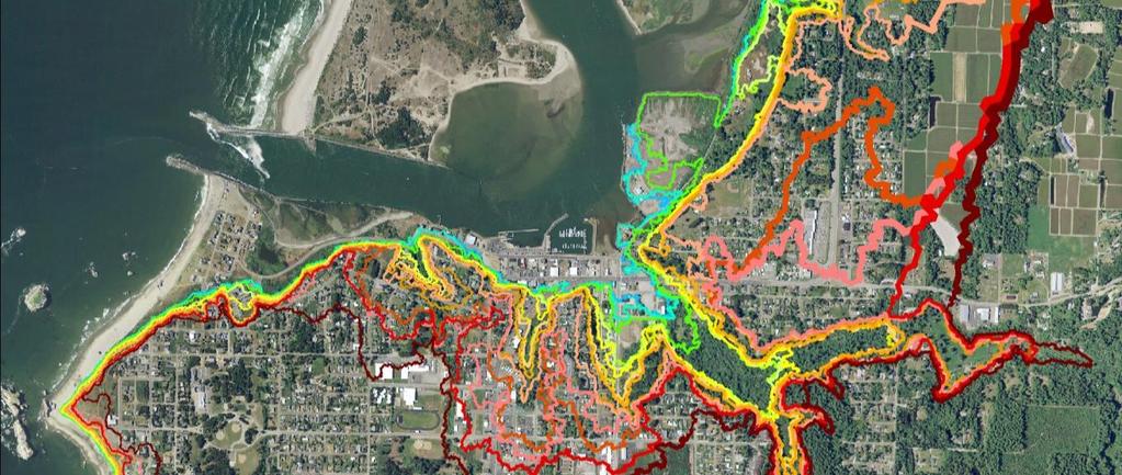
25 INUNDATION AND EVACUATION MAP PRODUCTS Inundation Maps (TIMs) 7 inundations whole coast 5 Local CSZ Tsunami T-Shirt Scenarios (SM1, M1, L1, XL1, XXL1 splay fault scenarios) MHHW Tide Coseismic subsidence taken into account Maps include wave time series, inundated building exposure, and wave elevation profiles 2 Distant Alaska Scenarios Alaska 1964 Alaska Max Evacuation Brochures 2 inundations in towns XXL1 Alaska Max Routes, preparedness information Evacuation Mapper 2 inundations whole coast XXL1 + Alaska Max on Google type base maps

26 Tsunami Evacuation Map Brochure Explanation (tested for color blindness)

27 MAPPER

28 Tsunami Inundation Map (TIM) - Local Cascadia Tsunamis Shows Cascadia tsunami arrival at Brookings, OR ~18 minutes Base map is lidar-derived shaded relief. GSA, Vancouver, BC, /28/201 4 DOGAMI Tsunami Inundation Map Curr-16, Plate 1

29 Tsunami Inundation Map (TIM) - Distant Tsunamis Brookings, Oregon DOGAMI Tsunami Inundation Map Curr-16, Plate 2
New Oregon Tsunami Simulation Scenarios, Published Data, and Probable Effect on the Oregon Building Code
 New Oregon Tsunami Simulation Scenarios, Published Data, and Probable Effect on the Oregon Building Code George R. Priest, Oregon Dept. of Geology and Mineral Industries Presentation to the workshop on
Tsunami potential and modeling
 Tsunami potential and modeling GEORGE PRIEST OREGON DEPT. OF GEOLOGY AND MINERAL INDUSTRIES NEWPORT COASTAL FIELD OFFICE April 7, 2012 GeoPRISMS Cascadia Workshop, Portland, Oregon What creates most uncertainty
Cascadia Seismic Event Planning for the Maritime Community
 Cascadia Seismic Event Planning for the Maritime Community Jonathan Allan, Oregon Dept. of Geology and Mineral Industries Presentation to Annual Pacific Northwest Waterways Association Meeting (PNWA) October
Natural Hazards Journal of the International Society for the Prevention and Mitigation of Natural Hazards ISSN X
 New constraints on coseismic slip during southern Cascadia subduction zone earthquakes over the past years implied by tsunami deposits and marine turbidites George R. Priest, Robert C. Witter, Yinglong
FROM: GEORGE PRIEST, Tsunami Specialist, Oregon Department of Geology and Mineral Industries
 June 12, 2015 MEMORANDUM TO: SPEAKERS AND DISCUSSION PARTICIPANTS FROM: GEORGE PRIEST, Tsunami Specialist, Oregon Department of Geology and Mineral Industries SUBJECT: NOTES FROM THE MAY 18, 2015 WORKSHOP:
The 1700/01/26 Cascadia subduction zone Earthquake and Tsunami
 Jason R. Patton GEO 142 1/13/15 Abstract: Cascadia subduction zone earthquakes (CSZ) can generate strong ground shaking and deadly tsunamis. Geologists used sediment cores and stream bank exposures to
Scientific Research on the Cascadia Subduction Zone that Will Help Improve Seismic Hazard Maps, Building Codes, and Other Risk-Mitigation Measures
 Scientific Research on the Cascadia Subduction Zone that Will Help Improve Seismic Hazard Maps, Building Codes, and Other Risk-Mitigation Measures Art Frankel U.S. Geological Survey Seattle, WA GeoPrisms-Earthscope
OREGON DEPARTMENT OF GEOLOGY & MINERAL INDUSTRIES
 OREGON DEPARTMENT OF GEOLOGY & MINERAL INDUSTRIES Mission: Provide Earth Science Information To Make Oregon Safe and Prosperous EARTHQUAKES & TSUNAMIS S Lidar Earthquake/Tsunami Science Educate & Mitigate
Long-Term Paleoseismology in Cascadia: Probabilities, Clustering, and patterns of Energy Release
 Long-Term Paleoseismology in Cascadia: Probabilities, Clustering, and patterns of Energy Release Chris Goldfinger College of Earth, Ocean and Atmospheric Sciences, Oregon State University Active Tectonics
Pacific Ocean Tsunami Generated by Japan Earthquake
 Pacific Ocean Tsunami Generated by Japan Earthquake Near the earthquake, there were only ~20 minutes to evacuate. A local tsunami for Japan. Travel times are well known for tsunamis crossing the Pacific
Probabilistic Tsunami Hazard Analysis. Hong Kie Thio AECOM, Los Angeles
 Probabilistic Tsunami Hazard Analysis Hong Kie Thio AECOM, Los Angeles May 18, 2015 Overview Introduction Types of hazard analysis Similarities and differences to seismic hazard Methodology Elements o
The Cascading Hazards from Cascadia s Earthquakes
 Tsunamis The Cascading Hazards from Cascadia s Earthquakes Earthquakes (Nisqually earthquake, Seattle, WA) Volcanoes (Mt St Helens eruption, WA) Joan Gomberg gomberg@usgs.gov Landslides (Oso landslide,
What scientists know and do not know about the big one at Cascadia
 What scientists know and do not know about the big one at Cascadia Kelin Wang Pacific Geoscience Centre, Geological Survey of Canada Natural Resources Canada The Cascadia Subduction Zone M 7.3, 1946 Rupture
Landslide & Coastal Erosion Risk Reduction at Oregon s Water/Wastewater Networks
 Landslide & Coastal Erosion Risk Reduction at Oregon s Water/Wastewater Networks Laura Gabel, RG (with Bill Burns, RG & Jonathan Allan, Ph. D) Oregon Department of Geology and Mineral Industries (541)
Appendix P: Models of Earthquake Recurrence and Down-Dip Edge of Rupture for the Cascadia Subduction Zone
 Appendix P: Models of Earthquake Recurrence and Down-Dip Edge of Rupture for the Cascadia Subduction Zone Arthur Frankel and Mark Petersen U.S. Geological Survey Introduction Logic trees for the recurrence
Active Tectonics. Earthquakes, Uplift, and Landscape. Edward A. Keller University of California, Santa Barbara
 Prentice Hall Earth Science Series SUB Gottingen 214 80416X, im ^, 2002 A 7883 lllllllilwii Active Tectonics Earthquakes, Uplift, and Landscape Second Edition V Edward A. Keller University of California,
Predicting tsunami waves and currents on the West Coast of Canada: A case study for Ucluelet, BC
 Predicting tsunami waves and currents on the West Coast of Canada: A case study for Ucluelet, BC Josef Cherniawsky, Kelin Wang and Roy Walters Institute of Ocean Sciences, Fisheries & Oceans Canada Pacific
Tsunami Hazard Map of the Warrenton Area, Clatsop County, Oregon
 CEDAR Lewis STATE OF OREGON DEPARTMENT OF GEOLOGY AND MINERAL INDUSTRIES DONALD A. HULL, STATE GEOLOGIST 124 Tsunami Hazard Map of the Warrenton Area, Clatsop County, Oregon 1999 MAP EXPLANATION (see accompanying
The Three Things You Need to Know About Tsunami Preparedness Patrick Corcoran, Oregon Sea Grant,
 The Three Things You Need to Know About Tsunami Preparedness Patrick Corcoran, Oregon Sea Grant, 10.11.13 NSF/CEETEP Workshop for Coastal Educators, October 11-14, Astoria, OR The Bottom Line Giant Earthquakes
Surviving the Big One: Understanding and Preparing for a Major Earthquake in Western Oregon
 Surviving the Big One: Understanding and Preparing for a Major Earthquake in Western Oregon May 21, 2013 City of Salem Salem Public Library Althea Rizzo, Geological Hazards Program Coordinator Oregon Emergency
Tsunami inundation at Crescent City, California generated by earthquakes along the Cascadia Subduction Zone
 GEOPHYSICAL RESEARCH LETTERS, VOL. 34, L20601, doi:10.1029/2007gl030188, 2007 Tsunami inundation at Crescent City, California generated by earthquakes along the Cascadia Subduction Zone Burak Uslu, 1 José
Marine Studies Initiative Building Site Selection TAB U
 Marine Studies Initiative Building Site Selection TAB U Site Selection Criteria Life Safety: Seismic/Tsunami Impacts MSI Program Delivery: Education, Research, Engagement Budgetary: Total Capital & Operating
Evaluation and Application of Probabilistic Tsunami Hazard Analysis in California
 Evaluation and Application of Probabilistic Tsunami Hazard Analysis in California Phase 1: Work Group Review of Methods, Source Characterization, and Applications of the Crescent City Demonstration Project
AN ABSTRACT OF THE DISSERTATION OF
 AN ABSTRACT OF THE DISSERTATION OF Hyoungsu Park for the degree of Doctor of Philosophy in Civil Engineering presented on March 10, 2016. Title: Probabilistic Tsunami Hazard and Damage Assessment of the
Probabilistic Tsunami Hazard Maps and GIS
 2005 ESRI International User Conference, San Diego, California, July 2005, Proceedings, http://gis.esri.com/library/userconf/index.html. Probabilistic Tsunami Hazard Maps and GIS Florence L. Wong 1, Eric
Tsunami Hazard Assessment of the Ocosta School Site in Westport, WA
 Tsunami Hazard Assessment of the Ocosta School Site in Westport, WA Final Report: September 11, 2013 Supercedes February 24, 2013 Report Frank González, Randy LeVeque and Loyce Adams University of Washington
TSUNAMI INUNDATION MODELING: SENSITIVITY OF VELOCITY AND MOMENTUM FLUX TO BOTTOM FRICTION WITH APPLICATION TO BUILDING DAMAGE AT SEASIDE, OREGON
 TSUNAMI INUNDATION MODELING: SENSITIVITY OF VELOCITY AND MOMENTUM FLUX TO BOTTOM FRICTION WITH APPLICATION TO BUILDING DAMAGE AT SEASIDE, OREGON Hyoungsu Park 1, Dane Wiebe 2, Daniel Cox 3, and Katherine
TSUNAMI HAZARD MAPS OF THE ANACORTES BELLINGHAM AREA, WASHINGTON MODEL RESULTS FROM A ~2,500-YEAR CASCADIA SUBDUCTION ZONE EARTHQUAKE SCENARIO
 N A T U R A L R E S O U R C E S TSUNAMI HAZARD MAPS OF THE ANACORTES BELLINGHAM AREA, WASHINGTON MODEL RESULTS FROM A ~2,500-YEAR CASCADIA SUBDUCTION ZONE EARTHQUAKE SCENARIO by Daniel W. Eungard, Corina
Forecasting Future Earthquakes from Tsunami Deposits and Simulation
 Forecasting Future Earthquakes from Tsunami Deposits and Simulation Kenji Satake Earthquake Research Institute The University of Tokyo satake@eri.u-tokyo.ac.jp Contents 1. Earthquake Recurrence and Forecast
Lessons from the 2004 Sumatra earthquake and the Asian tsunami
 Lessons from the 2004 Sumatra earthquake and the Asian tsunami Kenji Satake National Institute of Advanced Industrial Science and Technology Outline 1. The largest earthquake in the last 40 years 2. Tsunami
NUMERICAL SIMULATION AS GUIDANCE IN MAKING TSUNAMI HAZARD MAP FOR LABUAN ISLAND
 NUMERICAL SIMULATION AS GUIDANCE IN MAKING TSUNAMI HAZARD MAP FOR LABUAN ISLAND MOHD RIDZUAN bin Adam Supervisor: Fumihiko IMAMURA MEE09199 ABSTRACT At the northeast end of the South China Sea, tsunamis
BEACH AND SHORELINE DYNAMICS IN THE CANNON BEACH LITTORAL CELL; IMPLICATIONS FOR DUNE MANAGEMENT
 State of Oregon Oregon Department of Geology and Mineral Industries Brad Avy, State Geologist OPEN FILE REPORT O-17-XX BEACH AND SHORELINE DYNAMICS IN THE CANNON BEACH LITTORAL CELL; IMPLICATIONS FOR DUNE
Earthquakes, volcanic eruptions, tsunamis (why do we live here?) Tectonic plates. Tectonic plates: Juan de Fuca. Volcanism the past 37 million years
 Tectonic plates. Tectonic plates: Juan de Fuca. Volcanism the past 37 million years") Earthquakes, volcanic eruptions, tsunamis (why do we live here?) Tectonic plates Tectonic plates: Juan de Fuca Volcanism the past 37 million years Tectonic plates: Juan de Fuca Volcanism the past 37 million
Earthquakes, volcanic eruptions, tsunamis (why do we live here?) Tectonic plates Tectonic plates: Juan de Fuca Volcanism the past 37 million years Tectonic plates: Juan de Fuca Volcanism the past 37 million
Deformation cycles of great subduction earthquakes in a viscoelastic Earth
 Deformation cycles of great subduction earthquakes in a viscoelastic Earth Kelin Wang Pacific Geoscience Centre, Geological Survey of Canada School of Earth and Ocean Science, University of Victoria????
TSUNAMI HAZARD ASSESSMENT FOR THE CENTRAL COAST OF PERU USING NUMERICAL SIMULATIONS FOR THE 1974, 1966 AND 1746 EARTHQUAKES
 TSUNAMI HAZARD ASSESSMENT FOR THE CENTRAL COAST OF PERU USING NUMERICAL SIMULATIONS FOR THE 1974, 1966 AND 1746 EARTHQUAKES Sheila Yauri Supervisor: Yushiro FUJII MEE10521 Bunichiro SHIBAZAKI ABSTRACT
2. Tsunami Source Details
 2. Tsunami Source Details The Northland area faces a range of potential tsunamigenic sources that include several local and distant fault systems and underwater landslides. A NIWA study (Goff et al. 2006)
The Impacts of the Cascadia Subduction Zone Earthquake on Oregon. Dr. Althea Rizzo Oregon Military Department Office Of Emergency Management
 The Impacts of the Cascadia Subduction Zone Earthquake on Oregon Dr. Althea Rizzo Oregon Military Department Office Of Emergency Management What are the geologic hazards in Oregon? Earthquakes Tsunami
Portland Water Bureau. Preparing Portland s Water Supply for The Big One. July 11, Tim Collins, P.E., G.E.
 Portland Water Bureau Preparing Portland s Water Supply for The Big One July 11, 2018 Tim Collins, P.E., G.E. Presentation Outline Portland water system overview Pacific Northwest seismic hazards Building
crustal structure experiment beneath Wairarapa - Wellington area: results from SAHKE
 crustal structure experiment beneath Wairarapa - Wellington area: results from SAHKE Tim Stern and SAHKE team* * VUW, GNS, University of Southern California, University of Tokyo(Japan) SAHKE = Seismic
REPORT TO THE PLANNING, TRANSPORTATION AND PROTECTIVE SERVICES COMMITTEE MEETING OF JUNE 26, 2013
 PPS/PS 2013-07 REPORT TO THE PLANNING, TRANSPORTATION AND PROTECTIVE SERVICES COMMITTEE MEETING OF JUNE 26, 2013 SUBJECT UPDATES TO THE CAPITAL REGIONAL DISTRICT MODELLING OF POTENTIAL TSUNAMI INUNDATION
The Pattern Method for Incorporating Tidal Uncertainty Into Probabilistic Tsunami Hazard Assessment (PTHA)
") The Pattern Method for Incorporating Tidal Uncertainty Into Probabilistic Tsunami Hazard Assessment (PTHA) Loyce M. Adams Randall J. LeVeque Frank I. González March 4, 2014 Abstract In this paper we describe
The Pattern Method for Incorporating Tidal Uncertainty Into Probabilistic Tsunami Hazard Assessment (PTHA) Loyce M. Adams Randall J. LeVeque Frank I. González March 4, 2014 Abstract In this paper we describe
Activity Turbidites in a Jar
 Sand Dikes & Marine Turbidites Activity Turbidites in a Jar Paleoseismology is the study of the timing, location, and magnitude of prehistoric earthquakes preserved in the geologic record. Knowledge of
What is a tsunami? Capital Regional District Tsunami Frequently Asked Questions (FAQ s) Tsunami (soo-nah-mee)
 Tsunami (soo-nah-mee)") Tsunami (soo-nah-mee) Tsunamis (Japanese translation harbour wave ) are waves with a great distance between crests, and are caused by any widespread, sudden movement of large volumes of water. The tsunami
Tsunami (soo-nah-mee) Tsunamis (Japanese translation harbour wave ) are waves with a great distance between crests, and are caused by any widespread, sudden movement of large volumes of water. The tsunami
Riskscape module Documentation: Inundation Modelling in Bay of Plenty. X. Wang C. Mueller
 Riskscape module Documentation: Inundation Modelling in Bay of Plenty X. Wang C. Mueller CONTENTS 1.0 GENERAL INFORMATION... 2 1.1 SITE OF STUDY... 5 1.2 SOURCE SCENARIOS... 5 1.3 NUMERICAL MODEL... 5
Distribution and sedimentary characteristics of tsunami deposits along the Cascadia margin of western North America
 Sedimentary Geology 200 (2007) 372 386 www.elsevier.com/locate/sedgeo Distribution and sedimentary characteristics of tsunami deposits along the Cascadia margin of western North America Robert Peters a,,
2.2.7 Backbarrier flats
 FIGURE 24. VERTICAL PHOTOGRAPH SHOWING THE DEVELOPMENT OF SMALL PARABOLIC DUNES FROM BLOWOUTS IN A LARGE RELICT FOREDUNE NORTHWEST OF HUNTER'S CREEK. PHOTOGRAPH COURTESY OF CAR'T'ER HOLT HARVEY FORESTS
GEOL 10: Environmental Geology Mid Term II Study Guide
 (1) 10 pts. Use the seismographs below, along with the travel time plot for California, and the location map for seismographs in this region to do the following: a. Determine the origin time for the earthquake
Earthquakes: What s Shaking? Yumei Wang, Geohazards Engineer, PE, Oregon Dept of Geology and Mineral Industries (DOGAMI)
") Earthquakes: What s Shaking? Yumei Wang, Geohazards Engineer, PE, Oregon Dept of Geology and Mineral Industries (DOGAMI) June 14, 2016 WRECA Source: https://www.youtube.com/watch?v=ru0j1x5zrl4&list=plb9ce291f48c9207c&index=5
Earthquakes: What s Shaking? Yumei Wang, Geohazards Engineer, PE, Oregon Dept of Geology and Mineral Industries (DOGAMI) June 14, 2016 WRECA Source: https://www.youtube.com/watch?v=ru0j1x5zrl4&list=plb9ce291f48c9207c&index=5
2/19/2014. Indonesian Eruption Update for February 11, 2014: Kelut and Sinabung Erik Klemetti 2/11/2014
 Geology 15 Lecture 10 Schedule: HAZARD UPDATE! Earthquake Report Sign Up (1 at 50 points) First come first served http://earthquake.usgs.gov/earthquakes/eqarchives/poster/ Mid Term #1 3/3 200 points study
A GLOBAL SURGE OF GREAT EARTHQUAKES FROM AND IMPLICATIONS FOR CASCADIA. Thorne Lay, University of California Santa Cruz
 A GLOBAL SURGE OF GREAT EARTHQUAKES FROM 2004-2014 AND IMPLICATIONS FOR CASCADIA Thorne Lay, University of California Santa Cruz Last 10 yrs - 18 great earthquakes: rate 1.8/yr; rate over preceding century
doi: /2002GL015170
 doi: 10.1029/2002GL015170 GEOPHYSICAL RESEARCH LETTERS, VOL. 29, NO. 20, 1948, doi:10.1029/2002gl015170, 2002 Modeling the 1100 bp paleotsunami in Puget Sound, Washington Shunichi Koshimura Disaster Reduction
Title. Author(s)Heki, Kosuke. CitationScience, 332(6036): Issue Date Doc URL. Type. File Information. A Tale of Two Earthquakes
Heki, Kosuke. CitationScience, 332(6036): Issue Date Doc URL. Type. File Information. A Tale of Two Earthquakes") Title A Tale of Two Earthquakes Author(s)Heki, Kosuke CitationScience, 332(6036): 1390-1391 Issue Date 2011-06-17 Doc URL http://hdl.handle.net/2115/48524 Type article (author version) File Information
Title A Tale of Two Earthquakes Author(s)Heki, Kosuke CitationScience, 332(6036): 1390-1391 Issue Date 2011-06-17 Doc URL http://hdl.handle.net/2115/48524 Type article (author version) File Information
Lidar Illustrated 2012 CALENDAR OREGON DEPARTMENT OF GEOLOGY AND MINERAL INDUSTRIES
 Lidar Illustrated 2012 CALENDAR OREGON DEPARTMENT OF GEOLOGY AND MINERAL INDUSTRIES Lidar Technology & Coverage in Oregon DOGAMI APPLICATIONS FOR HIGH-RESOLUTION LIDAR IMAGE: USGS Lidar (light detection
Rupture Models of the Great 1700 Cascadia Earthquake Based on Microfossil Paleoseismic Observations
 Rupture Models of the Great 1700 Cascadia Earthquake Based on Microfossil Paleoseismic Observations by Pei-Ling Wang M.Sc., National Taiwan University, 2010 B.A., National Taipei University, 2007 A Thesis
The Bottom of the Ocean
 The Bottom of the Ocean Overview: In this lesson, students study bathymetric features of the ocean, predict how bathymetric features influence propagation and runup, then analyze an animation of a tsunami
Differentiating earthquake tsunamis from other sources; how do we tell the difference?
 Differentiating earthquake tsunamis from other sources; how do we tell the difference? David Tappin (1), Stephan Grilli (2), Jeffrey Harris (2), Timothy Masterlark (3), James Kirby (4), Fengyan Shi Shi
2013 SCEC Annual Report
 2013 SCEC Annual Report Collaborative research: Documentation of Tsunami Deposits in the Carpinteria Estuary: A signal of Great Earthquakes on the Pitas Point Thrust L. Reynolds, A. Simms, T.K. Rockwell,
Introduction to Environmental Geology, 5e Case History: Indonesian Tsunami Indonesian Tsunami (2) Introduction Historic Tsunamis
 Introduction Historic Tsunamis") 1 2 3 4 5 6 7 8 9 Introduction to Environmental Geology, 5e Chapter 7 Tsunami Case History: Indonesian Tsunami December 26, 2004, within a few hours, close to 250,000 people were killed With no warning
1 2 3 4 5 6 7 8 9 Introduction to Environmental Geology, 5e Chapter 7 Tsunami Case History: Indonesian Tsunami December 26, 2004, within a few hours, close to 250,000 people were killed With no warning
Probable Maximum Tsunami due to an Earthquake in the Makran Subduction Zone
 Probable Maximum Tsunami due to an Earthquake in the Makran Subduction Zone Ahmed Jemie Dababneh, Ph.D., P.E., Benjamin Ferguson, P.E. and, Daniel J. Barton, P.E. Paul C. Rizzo Associates, Inc. Pittsburgh,
Introduction to Environmental Geology, 5e
 Lecture Presentation prepared by X. Mara Chen, Salisbury University Introduction to Environmental Geology, 5e Edward A. Keller Chapter 7 Tsunami Case History: Indonesian Tsunami December 26, 2004, within
Seismic Hazard Assessment of Switzerland, Falko Bethmann October 1 st, 2008
 Seismic Hazard Assessment of Switzerland, 2004 Falko Bethmann October 1 st, 2008 Outline Definition of earthquake sources Definition of seismic recurrence characteristics for each source Ground motion
Linkage to the National Program
 Linkage to the National Program Frank González Pacific Marine Environmental Laboratory Seattle, WA Frank González, NOAA TIME Center, PMEL, Seattle, WA NOAA is about FORECASTS and WARNINGS -Hurricanes Sunspots
How to communicate Cascadia Subduction Zone earthquake hazards
 How to communicate Cascadia Subduction Zone earthquake hazards Tom Brocher Research Geophysicist Earthquake Science Center U.S. Geological Survey Menlo Park, California Seattle Post-Intelligencer Lessons
SIMULATION OF A WORST CASE TSUNAMI SCENARIO FROM THE MANILA TRENCH TO VIETNAM
 SIMULATION OF A WORST CASE TSUNAMI SCENARIO FROM THE MANILA TRENCH TO VIETNAM Nguyen Hong Phuong, Vu Ha Phuong, Pham The Truyen Earthquake Information and Tsunami Warning Centre, VAST OUTLINE Earthquake
Indian Ocean Tsunami Warning System: Example from the 12 th September 2007 Tsunami
 Indian Ocean Tsunami Warning System: Example from the 12 th September 2007 Tsunami Charitha Pattiaratchi 1 Professor of Coastal Oceanography, The University of Western Australia Email: chari.pattiaratchi@uwa.edu.au
Earthquakes and Earthquake Hazards Earth - Chapter 11 Stan Hatfield Southwestern Illinois College
 Earthquakes and Earthquake Hazards Earth - Chapter 11 Stan Hatfield Southwestern Illinois College What Is an Earthquake? An earthquake is the vibration of Earth, produced by the rapid release of energy.
Summary Visualizations for Coastal Spatial Temporal Dynamics
 Summary Visualizations for Coastal Spatial Temporal Dynamics October 24 2011 Providence, RI Sidharth Thakur 1, Laura Tateosian 2, Helena Mitasova, Eric Hardin, and Margery Overton 1. sthakur@renci.org,
with tsunami simulation Author(s) Shishikura, Masanobu; Sawai, Y.; Na Symposium on Backwards Problem in G
 Shishikura, Masanobu; Sawai, Y.; Na Symposium on Backwards Problem in G") Reconstruction of the 869 Jogan Ear Titlethe 2011 Tohoku earthquake, by geol with tsunami simulation Author(s) Shishikura, Masanobu; Sawai, Y.; Na Proceeding of TC302 Symposium Osaka Citation Symposium
Reconstruction of the 869 Jogan Ear Titlethe 2011 Tohoku earthquake, by geol with tsunami simulation Author(s) Shishikura, Masanobu; Sawai, Y.; Na Proceeding of TC302 Symposium Osaka Citation Symposium
NUMERICAL SIMULATION OF TSUNAMI PROPAGATION AND INUNDATION ALONG THE RAKHINE COAST AREAS IN MYANMAR
 NUMERICAL SIMULATION OF TSUNAMI PROPAGATION AND INUNDATION ALONG THE RAKHINE COAST AREAS IN MYANMAR Su Hninn Htwe Supervisor: Bunichiro SHIBAZAKI MEE12619 Yushiro FUJII ABSTRACT This study aimed to assess
News Release December 30, 2004 The Science behind the Aceh Earthquake
 News Release December 30, 2004 The Science behind the Aceh Earthquake PASADENA, Calif. - Kerry Sieh, the Robert P. Sharp Professor of Geology at the California Institute of Technology and a member of Caltech's
Very Fine Grained-, Very Coarse Grained-, and Internally Stratified-Tsunami Deposits: Geologic Constraints on Flow Conditions
 Very Fine Grained-, Very Coarse Grained-, and Internally Stratified-Tsunami Deposits: Geologic Constraints on Flow Conditions By: Curt Peterson, Portland State University Ken Cruikshank, Portland State
Earthquake prediction. Southwest BC: Our local dangerous fault zones
 Earthquake prediction Prediction: specifies that an earthquake of a specific magnitude will occur in a defined region during a particular period: There will be a M 7 or larger earthquake in southern California
4. Regions Northland Region Distant Eastern source: South America (Chile/Peru)
") 4. Regions Maximum water surface elevation images are presented below for tsunamis generated from the sources discussed above; Distant Eastern source: South America (Chile/Peru), Regional Eastern source:
4. Regions Maximum water surface elevation images are presented below for tsunamis generated from the sources discussed above; Distant Eastern source: South America (Chile/Peru), Regional Eastern source:
8.0 SUMMARY AND CONCLUSIONS
 8.0 SUMMARY AND CONCLUSIONS In November 2008, Pacific Gas and Electric (PG&E) informed the U.S. Nuclear Regulatory Commission (NRC) that preliminary results from the Diablo Canyon Power Plant (DCPP) Long
The ITSU System in the Pacific Region and Future Upgrades
 The ITSU System in the Pacific Region and Future Upgrades Eddie Bernard Director, Pacific Marine Environmental Laboratory (PMEL) NOAA/USA Pacific Tsunami Warning Center OPERATIONAL ACTIVITIES SEISMIC DATA
Magnitude 7.0 N of ANCHORAGE, ALASKA
 A magnitude 7.0 earthquake occurred just before 8:30 am local time 8 miles north of Anchorage at a depth of 40.9 km (25.4 miles). There are reports of major infrastructure damage and damage to many homes
A Method for Estimating Casualties due to the Tsunami Inundation Flow
 A Method for Estimating Casualties due to the Tsunami Inundation Flow Shunichi Koshimura Disaster Reduction and Human Renovation Institution Toshitaka Katada Depertment of Civil Engineering, Gunma University
By Chris Mikes and David Fleck Digital Terrain Analysis GEOG 593. Overview
 Earthquake and Infrastructure Damage Analysis in Multnomah and Clackamas Counties: The Application of LiDAR In The Development of an Emergency Response Plan By Chris Mikes and David Fleck Digital Terrain
Earthquakes and Tsunamis
 Earthquakes and Tsunamis Kenji Satake Earthquake Research Institute University of Tokyo 1 Part I 2011 Tohoku earthquake and tsunami 2 Fukushima Dai ichi NPP accident Earthquake ground motion Reactors automatically
Mechanism of tsunami generation,propagation and runup -sharing experiences with Japanese
 Mechanism of tsunami generation,propagation and runup -sharing experiences with Japanese Mechanism of tsunami generation Predicting the propagation, runup and inundation of tsunamis Near and far-field
REAL-TIME TSUNAMI INUNDATION FORECAST STUDY IN CHIMBOTE CITY, PERU
 REAL-TIME TSUNAMI INUNDATION FORECAST STUDY IN CHIMBOTE CITY, PERU Nabilt Moggiano Supervisor: Kenji SATAKE MEE16720 ABSTRACT For rapid forecast of tsunami inundation during a tsunamigenic event, we constructed
Magnitude 8.2 FIJI. A magnitude 8.2 earthquake occurred km (226.7 mi) E of Suva, Fiji at a depth of km (350 miles).
 E of Suva, Fiji at a depth of km (350 miles).") A magnitude 8.2 earthquake occurred 364.8 km (226.7 mi) E of Suva, Fiji at a depth of 563.4 km (350 miles). There is no risk of a tsunami from an earthquake at this depth. Images courtesy of Google The
A magnitude 8.2 earthquake occurred 364.8 km (226.7 mi) E of Suva, Fiji at a depth of 563.4 km (350 miles). There is no risk of a tsunami from an earthquake at this depth. Images courtesy of Google The
Earthquakes in Oregon: Past, Present & Future. Earthquakes in OREGON: Are we ready for the Big One?
 Earthquakes in Oregon: Past, Present & Future Earthquakes in OREGON: Are we ready for the Big One? Scott Burns Portland State University Department of Geology New Yorker Article: 7/20/15 The Really Big
Overview of Seismic Source Characterization for the Diablo Canyon Power Plant
 Overview of Seismic Source Characterization for the Diablo Canyon Power Plant Steve Thompson (LCI and SSC TI Team), for SWUS GMC Workshop 1, March 19, 2013 Questions from TI Team Summarize tectonic setting.
Interpretive Map Series 24
 Oregon Department of Geology and Mineral Industries Interpretive Map Series 24 Geologic Hazards, Earthquake and Landslide Hazard Maps, and Future Earthquake Damage Estimates for Six Counties in the Mid/Southern
Models of tsunami waves at the Institute of Ocean Sciences
 Models of tsunami waves at the Institute of Ocean Sciences Josef Cherniawsky and Isaac Fine Ocean Science Division, Fisheries & Oceans Canada, Sidney, BC Port Alberni, March 27, 2014 Acknowledgements:
What causes tsunamis?
 What causes tsunamis? Any movement/displacement of the ocean floor can generate the energy that forms a tsunami. However, tsunamis are usually generated by large, shallow earthquakes, which have epicenters
THE DEPOSITS OF TSUNAMIS WESLEY PESANTEZ, CATHERINE NIELD, COLIN WINTER
 THE DEPOSITS OF TSUNAMIS WESLEY PESANTEZ, CATHERINE NIELD, COLIN WINTER AN OVERVIEW OF OUR SEMINAR WHAT IS A TSUNAMI WHY STUDY TSUNAMIS PROPERTIES OF TSUNAMIS TSUNAMI HYDRODYNAMICS IDEALIZED DEPOSITS SEDIMENT
Overview of the Seismic Source Characterization for the Palo Verde Nuclear Generating Station
 Overview of the Seismic Source Characterization for the Palo Verde Nuclear Generating Station Scott Lindvall SSC TI Team Lead Palo Verde SSC SSHAC Level 3 Project Tuesday, March 19, 2013 1 Questions from
Finding an Earthquake Epicenter Pearson Education, Inc.
 Finding an Earthquake Epicenter Measuring the Size of Earthquakes Two measurements that describe the size of an earthquake are: 1. Intensity a measure of the degree of earthquake shaking at a given locale
M w 8.5 Tonga-Kermadec subduction zone scenario
 4.3.2. M w 8.5 Tonga-Kermadec subduction zone scenario The arrival times of the first and maximum waves (as calculated by the method outlined in section 4.1) for the tsunami generated by a M w 8.5 subduction
Preliminary Study of Possible Tsunami Hazards in Taiwan Region
 Preliminary Study of Possible Tsunami Hazards in Taiwan Region Xiaoming Wang and Philip L.-F. Liu Cornell University (First Draft on May 25 2006) (Second Draft on June 1 2006) (Final Update on June 8 2006)
Splay fault and megathrust earthquake slip in the Nankai Trough
 Earth Planets Space, 53, 243 248, 2001 Splay fault and megathrust earthquake slip in the Nankai Trough Phil R. Cummins, Takane Hori, and Yoshiyuki Kaneda Frontier Research Program for Subduction Dynamics,
Earthquakes Earth, 9th edition, Chapter 11 Key Concepts What is an earthquake? Earthquake focus and epicenter What is an earthquake?
 1 2 3 4 5 6 7 8 9 10 Earthquakes Earth, 9 th edition, Chapter 11 Key Concepts Earthquake basics. "" and locating earthquakes.. Destruction resulting from earthquakes. Predicting earthquakes. Earthquakes
20 mm/yr mm/yr BERI DTCH MRDR. WHAL Atka AFZ
 Coupling, Slip Partitioning and Arc Deformation Along the Aleutian Subduction zone M. Wyss, H. Avé Lallemant, D. Christensen, J. Freymueller, R. Hansen, P Haeussler, K. Jacob, M. Kogan, S. McNutt, J. Oldow,
The Coast: Beaches and Shoreline Processes
 1 2 3 4 5 6 7 8 9 The Coast: es and Shoreline Processes Trujillo & Thurman, Chapter 10 Oceanography 101 Chapter Objectives Recognize the various landforms characteristic of beaches and coastal regions.
Earthquakes. Building Earth s Surface, Part 2. Science 330 Summer What is an earthquake?
 Earthquakes Building Earth s Surface, Part 2 Science 330 Summer 2005 What is an earthquake? An earthquake is the vibration of Earth produced by the rapid release of energy Energy released radiates in all
RISK ASSESSMENT COMMUNITY PROFILE NATURAL HAZARDS COMMUNITY RISK PROFILES. Page 13 of 524
 RISK ASSESSMENT COMMUNITY PROFILE NATURAL HAZARDS COMMUNITY RISK PROFILES Page 13 of 524 Introduction The Risk Assessment identifies and characterizes Tillamook County s natural hazards and describes how
Manila subduction zone
 Manila subduction zone Andrew T.S. Lin SSC TI Team Member Taiwan SSHAC Level 3 PSHA Study Workshop #3, June 19 23, 2017 Taipei, Taiwan 1 1 Manila subduction zone Hazard Contribution Geometry Setting interface
The Coast: Beaches and Shoreline Processes Trujillo & Thurman, Chapter 10
 The Coast: es and Shoreline Processes Trujillo & Thurman, Chapter 10 Oceanography 101 Chapter Objectives Recognize the various landforms characteristic of beaches and coastal regions. Identify seasonal