OREGON DEPARTMENT OF GEOLOGY & MINERAL INDUSTRIES
|
|
|
- Edith Strickland
- 5 years ago
- Views:
Transcription


1 OREGON DEPARTMENT OF GEOLOGY & MINERAL INDUSTRIES Mission: Provide Earth Science Information To Make Oregon Safe and Prosperous EARTHQUAKES & TSUNAMIS S Lidar Earthquake/Tsunami Science Educate & Mitigate
2 Today s Presentation Earthquake and Tsunami Science Lessons from Japan 10,000-year History of Oregon Earthquakes New Tsunami Maps How to Get Involved
3 Earthquake and Tsunami Science


4 Earthquake Basics Earthquakes occur along a fault or fault system Bigger faults make bigger earthquakes Epicenter = the location on the earth s surface directly above the origin of the earthquake Bigger earthquakes last a longer time Magnitude = a measure of how much energy is released in all directions
5 Do you know Oregon s four kinds of earthquake sources? 1 Cascadia Subduction Zone Example: the 1700 earthquake that caused shaking and a tsunami that inundated the OR coast and reached as far as Japan. 2 Interplate Example: the 2001 Nisqually, WA earthquake that affected Washington and northwestern Oregon. 2 3 Volcanic Example: the 1980 Mount St. Helens eruption-related earthquakes. 4 Crustal Example: the 1993 Scotts Mills and Klamath Falls earthquakes. Crustal earthquakes also occur in SE Oregon where the crust is pulling apart.
6 Earthquake Frequency & Size There are many earthquakes each year, only some are felt. Number of Earthquakes Number of Earthquakes Energy Released per Year (World) per Year (USA) Earthquake Magnitude [Number of Atom Bombs] 1,300,000? ,000000? , , Klamath Falls ('93) Examples LA ('84) SF ('89) Kobe ('95) Haiti ('10) China ('76) ,003 Sumatra ('04), Japan ('11) , ,010 Alaska ('64) ,518 Chile ('60)


7 What Controls the Level of Shaking? Magnitude: More Energy Released Distance: Shaking declines with distance Local Soils: the soil type can amplify the shaking Loma Prieta, CA 1989 Northridge, CA 1994

8 Possible Shaking Intensity/Effects III. Weak Felt indoors, especially on upper floors of buildings. Vibrations similar to a passing truck. IV. Light Vibration felt like passing of heavy trucks. Stopped cars rock. Windows, dishes, doors rattle. Wooden walls and frames creak. V. Moderate Felt by nearly everyone; sleepers awakened. Small, unstable objects overturned. Doors swing. Pictures move. Pendulum clocks stop. VI. Strong Felt by all. People walk unsteadily. Some heavy furniture moved. Small objects fall off shelves. Pictures off walls. VII. Very strong Difficult to stand or walk. Noticed by drivers of cars. Slight to moderate damage in well-built structures; considerable damage in poorly built structures. VIII. Severe Steering of cars affected. Extensive damage to buildings with partial collapse. Fall of chimneys, factory stacks, columns, monuments, walls. Heavy furniture overturned. Wood-frame houses moved on foundations if not bolted. IX. Violent General panic. Damage to buildings ranges from collapse to serious damage.


9 M3.5 Earthquake Might be Felt February 16, 2012 San Francisco Area - Magnitude miles deep - 9:13am local time - Reported as Felt by 1,912 people Note the shaking intensity i colors


10 M5+ Earthquake Usually Felt February 13, 2012 Northern California - Magnitude miles deep - 1:07pm local time - Reported as Felt by 3,028 people Note the shaking intensity colors


11 Ground Can Shake Moderately For 30 Seconds Poor Soils Can Amplify Effects Damage Can be Moderate to Heavy (even with current building codes) M7 Earthquake Note the shaking intensity colors


12 Other Earthquake Effects: Liquefaction Subsidence/Uplift Landslides Fires Tsunamis Wave height
13 Large Earthquake Frequency


14 Topography Reflects Tectonic Plates Plates Move in 3 Ways: - Slide Past - Spread Out - Dive Under (Subduction)
15 Cascadia Subduction Zone (CSZ) North American Plate Overrides Juan de Fuca Plate Along Cascadia Subduction Zone at a rate of 1.5 inches/year


16 What is a tsunami? A tsunami is a series of waves usually caused by an undersea earthquake that displaces the ocean floor. But a tsunami is not really a wave that moves up and down; it s actually the ocean moving sideways as a massive surge or a wall of water. It s also known as a tidal wave. The Japanese word tsunami means harbor wave. A tsunami can generate waves for 12 to 24 hours. And the first wave is not always the biggest! Japan, 2011 The Boston Globe A tsunami travels across the open ocean at over 500mph, the speed of a jet airplane. As it reaches shallower water and approaches shore, it slows down but grows in height. A tsunami can happen at any time of day or year.
17 How are tsunamis created? Tsunami Evacuation Maps From Atwater et al., 1999
18 How are tsunamis created? Between earthquakes Tsunami Evacuation Maps From Atwater et al., 1999
19 How are tsunamis created? During an earthquake Tsunami Evacuation Maps From Atwater et al., 1999
20 How are tsunamis created? Minutes later Tsunami Evacuation Maps From Atwater et al., 1999


21 Tsunamis are more than a wave Waves break on shore Tsunamis are a higher ocean surface that just keep coming
22 Where do tsunamis come from? Local Oregon Tsunamis Distant Tsunamis
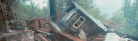
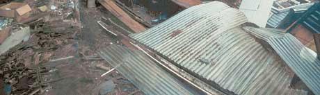
23 Lessons from Japan

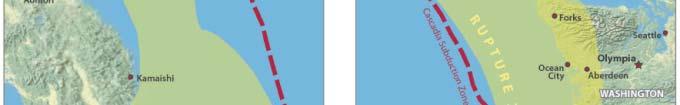
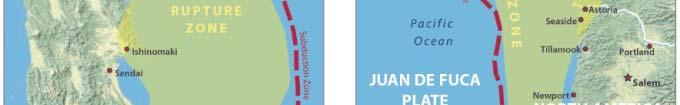

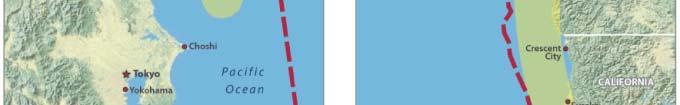
24 Subduction Zones Japan vs. Oregon


25 ShakeMap Comparison ShakeMap for March 11, 2011 Tohoku M9 Earthquake ShakeMap for Simulated M9 Cascadia Earthquake
26 How long did the ground shake in Japan? 3 minutes!


27 Tsunami Water Elevations First tsunami surges arrived in 15 minutes (Japan, 2011) 50 ft 100 ft
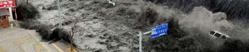
28 March 11, 2011 Tsunami


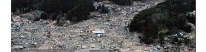
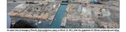

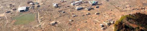
29 Lessons from March 11, 2011


30 Defenses Failed Pine Forests Sea Walls


31 Infrastructure Failed Overturned and Underwater Central Pier Tsunami wave height reached 39 feet Six spans of this bridge washed from 1,000 to 1,300 feet away Railroads no longer usable


32 Vertical Evacuation Failed In this City: 31 of 80 designated tsunami evacuation centers destroyed Disaster Management HQ
33 Go to High Ground! Disaster Management Headquarters 30 officials went to the roof 11 survived


34 Wood Buildings Perform Well in Earthquakes, But Poorly in Tsunamis Wood Houses Destroyed By Water Depth & Velocity At 6.5 to 8 feet deep: 72% destroyed 65% of destroyed buildings were simply washed away


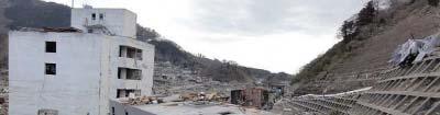

35 Reinforced Concrete Buildings Survive Better Than Wood but not always
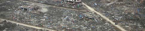
36 Tsunami water carries an enormous amount of debris
37 Before Tsunami at Sendai
38 After Tsunami at Sendai
39 What should you expect in Oregon? M9.0 Great Earthquake - Western Oregon will experience strong to violent shaking lasting for 2 or more minutes - This experience will be unmistakable - Bridges will fail; Expect to walk to high ground - 15 to 30 minutes later = start of tsunami - Tsunami waves will continue for at least 4 hours
40 Lessons from Japan Prepare your evacuation plan and go bag now When the ground shakes hard for a long time, evacuate immediately to high ground on foot Vertical evacuation is a last resort option Tsunami waves will arrive for several hours - First wave may not be the largest Wood buildings will not survive - Not all concrete or steel frame buildings will survive Help may not arrive for several to many days You can survive if you prepare and take action!


41 Earthquakes: What to do Indoors: Drop, cover, and hold on. Drop to the floor, take cover under a sturdy desk or table, and hold on to it firmly. In Bed: Hold on and stay there, protecting your head with a pillow. Outdoors: Move to a clear area if you can safely do so; avoid power lines, trees, signs, buildings, vehicles, and other hazards. Driving: Pull over to the side of the road, stop, and set the parking brake. Avoid overpasses, bridges, power lines, signs and other hazards. Stay inside the vehicle until the shaking is over. At the beach: Drop, cover and hold on until the shaking stops. Estimate how long the shaking lasts. If severe shaking lasts 20 seconds or more, immediately evacuate to high ground as a tsunami might have been generated by the earthquake. In a high-rise building: Drop, cover, and hold on. Avoid windows and other hazards. Do not use elevators.


42 What to Do: Local vs. Distant Tsunami Distant


43 Know Where to Go! (or not) In a local tsunami First wave arrives minutes after earthquake Evacuate on foot. Why? Bridges fail, roads blocked, traffic jams. Have a grab and go bag ready. In a distant tsunami First wave arrives 4 hours or more after earthquake in Alaska or elsewhere on Pacific Rim. If already outside hazard zone, stay there. Time for an official warning If your area has sirens, you might hear 3-minute siren blast. If not, sudden sea level change is last-ditch warning.
44 10,000 Year History of Earthquakes in the Pacific Northwest t


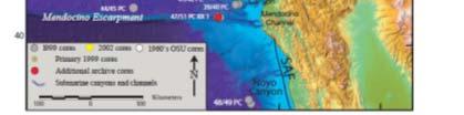
45 10,000-year History of Oregon Earthquakes Locations of soil core samples taken off the Oregon coast


46 Offshore Landslides Record Earthquakes Offshore landslides that have been generated from CSZ earthquakes produce turbidites. These turbidites can be measured from core samples like the one pictured here. The measuring of this mass, in addition to other sand deposits left lfin onshore estuaries, allow scientists to date and measure historical CSZ events. These historical CSZ events are then correlated between samples to create a comprehensive history of cascadia subduction zone events.
47 19 CSZ Events in Past 10,000 Years earthquake
 = - and - 2 Distant Scenarios (AK64 and AKMax) Reference:")


48 Science Team Modeled Many Tsunami Scenarios 5 Final Local CSZ Scenarios (S, M, L, XL, XXL) = - and - 2 Distant Scenarios (AK64 and AKMax) Reference: Simulating tsunami inundation at Bandon, Coos County, Oregon, using hypothetical Cascadia and Alaska earthquake scenarios Authors: Witter, R.C., Zhang, Y., Wang, K., Priest, G.R., Goldfinger, C., Stimely, L.L., English, J.T., and Ferro, P.A. Oregon Department of Geology and Mineral Industries Special Paper 43
49 DOGAMI Tsunami T-Shirts
50 Historical Event Size & Frequency Relate to the 5 Scenarios SB 379 (approximately)
51 Model Output to DOGAMI

 - Occurs at High Tide - Land")


 and")
52 DOGAMI Turns Models to Maps Turn Model Output Into Inundation Maps - 5 Local CSZ Tsunami T-Shirt Scenarios - (S, M, L, XL, XXL) - Occurs at High Tide - Land Subsidence Taken Into Account - Maps Include Other Relevant Information such as Wave Time Series, Inundation Exposure, and Wave Elevation Profiles - 2 Distant t Alaska a Scenarios - (Alaska 1964 (M9.2) & Alaska Max) Use XXL (worst local) and Alaska Max Use XXL (worst local) and Alaska Max (worst distant) for Evacuation Brochures
 87")
.")


53 Two Kinds of New Tsunami Maps Tsunami inundation maps (TIMs) 87 publications for Oregon s coast, each with two maps (local and distant). Available for purchase via Tsunami evacuation brochures 42 maps for Oregon s coast, covering population centers. Free maps. Do you live outside the map areas? See Evacuation Zone Map Viewer at g
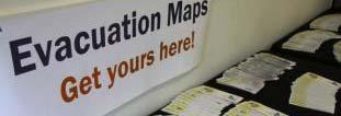
54 New Maps Tsunami Evacuation Maps
55 Example: Old Tsunami Evacuation Maps Note: Lakeside didn t have its own map before.


56 Community Determines Evacuation Elements
57
58 Evacuation Zone Map Viewer g


59 Mobile App for iphone and Android TsunamiEvac-NW
60 How to Get Involved

61 Tsunami Outreach Oregon To assist coastal communities in creating a local culture of preparedness and response


62 Tsunami Readiness Rallies Helped to Spread the Word


63 How You Can Help Join your local CERT group! Educates people about disaster preparedness for hazards Training in basic disaster response skills, such as fire safety, light search and rescue, team organization, and disaster medical operations. CERT members can assist others in their neighborhood or CERT members can assist others in their neighborhood or workplace following an event when professional responders are not immediately available to help.


64 How You Can Help An easy 9-step program to get yourself and your neighbors prepared for disaster. More info at
65 How You Can Help Prepare at home, work, and school Talk to your friends, family, and neighbors Volunteer for door-to-door outreach by contacting your local fire station Get emergency notifications via phone, cell, , text, etc. Sign up at your county government s website via emergency management department How You Can Help Thank you!
66 More Information Oregon Dept. of Geology and Mineral Industries (DOGAMI) (971) Or from your local fire station or city hall
Three Fs of earthquakes: forces, faults, and friction. Slow accumulation and rapid release of elastic energy.
 Earthquake Machine Stick-slip: Elastic Rebound Theory Jerky motions on faults produce EQs Three Fs of earthquakes: forces, faults, and friction. Slow accumulation and rapid release of elastic energy. Three
Cascadia Seismic Event Planning for the Maritime Community
 Cascadia Seismic Event Planning for the Maritime Community Jonathan Allan, Oregon Dept. of Geology and Mineral Industries Presentation to Annual Pacific Northwest Waterways Association Meeting (PNWA) October
Released Science Inquiry Task Location Grade 11
 Date: Your Name: Released Science Inquiry Task Location 2009 Grade 11 Science Directions: You will be completing an extended-response inquiry task called Location. Explain the reasons for all of your answers.
1. Why do earthquakes happen? 3. What type of mechanical waves are Primary or P waves? 4. What type of mechanical waves are Secondary or S waves?
 Name Period Earthquake Activity Background Information Earthquakes occur because of a sudden release of stored energy. This energy has built up over long periods of time as a result of tectonic forces
RECENT COMPREHENSIVE TSUNAMI MODELING FOR COASTAL OREGON
 RECENT COMPREHENSIVE TSUNAMI MODELING FOR COASTAL OREGON Speaker: George R. Priest, Oregon Dept. of Geology and Mineral Industries Pardee Keynote Symposium Great Earthquakes, the Cascadia Subduction Zone,
earthquakes 1. Earthquakes occur when plates grind against one another along cracks called faults.
 earthquakes BEGIN 1 earthquakes 1. Earthquakes occur when plates grind against one another along cracks called faults. 2 earthquakes 1. Earthquakes occur when plates grind against one another along cracks
The Three Things You Need to Know About Tsunami Preparedness Patrick Corcoran, Oregon Sea Grant,
 The Three Things You Need to Know About Tsunami Preparedness Patrick Corcoran, Oregon Sea Grant, 10.11.13 NSF/CEETEP Workshop for Coastal Educators, October 11-14, Astoria, OR The Bottom Line Giant Earthquakes
FOURTH GRADE HAZARDS 1 WEEK LESSON PLANS AND ACTIVITIES
 FOURTH GRADE HAZARDS 1 WEEK LESSON PLANS AND ACTIVITIES PLATE TECTONIC CYCLE OVERVIEW OF FOURTH GRADE VOLCANOES WEEK 1. PRE: Comparing different structures of volcanoes. LAB: Modeling three types of volcanoes.
Earthquake Hazards. Tsunami
 Earthquake Hazards Tsunami Review: What is an earthquake? Earthquake is the vibration (shaking) and/or displacement of the ground produced by the sudden release of energy. The point inside the Earth where
Earthquake Hazards. Tsunami
 Earthquake Hazards Tsunami Measuring Earthquakes Two measurements that describe the power or strength of an earthquake are: Intensity a measure of the degree of earthquake shaking at a given locale based
Mw 7.8, Southwest of Sumatra, Indonesia Wed, 2 March 2016 at 12:49:48 UTC M /03/03
 Earthquake overview AFGHANISTA N PAKISTA N INDIA A moment magnitude (Mw) 7.8 earthquake struck in South West, Indonesia. The epicentre was centered about 800 km West South West of Padang, Sumatra province,
How to communicate Cascadia Subduction Zone earthquake hazards
 How to communicate Cascadia Subduction Zone earthquake hazards Tom Brocher Research Geophysicist Earthquake Science Center U.S. Geological Survey Menlo Park, California Seattle Post-Intelligencer Lessons
Earthquake Hazards. Tsunami
 Earthquake Hazards Tsunami Review: What is an earthquake? Earthquake is the vibration (shaking) and/or displacement of the ground produced by the sudden release of energy. The point inside the Earth where
An earthquake can cause:
 Earthquakes An earthquake is a sudden rapid shaking of the earth. They are caused by the breaking and shifting of the rock beneath the earth s surface. Often found in conjunction with Plate tectonic boundaries.
20.1 Earthquakes. Chapter 20 EARTHQUAKES AND VOLCANOES. Earthquakes and plate boundaries 500 UNIT 6 EARTH S STRUCTURE
 Chapter 20 EARTHQUAKES AND VOLCANOES 20.1 Earthquakes In Chapter 19, you read about the San Andreas Fault, which lies along the California coast (Figure 20.1). This fault passes right through San Francisco
Earthquakes. Dr. Mark van der Meijde INTERNATIONAL INSTITUTE FOR GEO-INFORMATION SCIENCE AND EARTH OBSERVATION
 Earthquakes Dr. Mark van der Meijde vandermeijde@itc.nl INTERNATIONAL INSTITUTE FOR GEO-INFORMATION SCIENCE AND EARTH OBSERVATION Topics to handle Theory of earthquakes Mechanism Strength Measurements
What is a tsunami? Capital Regional District Tsunami Frequently Asked Questions (FAQ s) Tsunami (soo-nah-mee)
 Tsunami (soo-nah-mee)") Tsunami (soo-nah-mee) Tsunamis (Japanese translation harbour wave ) are waves with a great distance between crests, and are caused by any widespread, sudden movement of large volumes of water. The tsunami
Tsunami (soo-nah-mee) Tsunamis (Japanese translation harbour wave ) are waves with a great distance between crests, and are caused by any widespread, sudden movement of large volumes of water. The tsunami
Earthquake. earthquake, epicenters in the U.S. Kobe, Japan deaths
 Kobe, Japan 1995 5000 deaths Earthquakes It is estimated that there are 500,000 detectable earthquakes in the world each year. 100,000 of those can be felt, and 100 of them cause damage. The world's deadliest
New Oregon Tsunami Simulation Scenarios, Published Data, and Probable Effect on the Oregon Building Code
 New Oregon Tsunami Simulation Scenarios, Published Data, and Probable Effect on the Oregon Building Code George R. Priest, Oregon Dept. of Geology and Mineral Industries Presentation to the workshop on
"The Big One" by sea and not by land
 "The Big One" by sea and not by land By Los Angeles Times, adapted by Newsela staff on 03.24.14 Word Count 629 Surfer Lee Johnson emerges from the water at San Onofre State Beach, Calif., with the twin
PERSONAL DISASTER PREPAREDNESS
 PERSONAL DISASTER PREPAREDNESS WHY PREPARE? Saves Lives Protects Property Speeds Recovery Preparedness Minimizes Panic and Confusion Prepares for Recovery Earthquakes If you re prepared for Earthquakes,
We have previously looked at artificial seismograms such as this one here.
 We have previously looked at artificial seismograms such as this one here. S P A realistic Seismic Record Each vertical line = 1 minute Each horizontal line = 15 minutes Seismic station PMM is in Parkfield,
Earthquakes in Oregon: Past, Present & Future. Earthquakes in OREGON: Are we ready for the Big One?
 Earthquakes in Oregon: Past, Present & Future Earthquakes in OREGON: Are we ready for the Big One? Scott Burns Portland State University Department of Geology New Yorker Article: 7/20/15 The Really Big
2.3 Notes: Earthquake Damage Can Be Reduced
 2.3 Notes: Earthquake Damage Can Be Reduced Earthquakes can cause severe damage and loss of life Each year, there is about one earthquake with a magnitude of or higher-this is an extremely earthquake.
Earthquakes and Earth s Chapter. Interior
 Earthquakes and Earth s Chapter Interior 8.1 What Is an Earthquake? An earthquake is the vibration of Earth produced by the rapid release of energy Focus and Epicenter Focus is the point within Earth
Earthquakes & Volcanoes
 Earthquakes & Volcanoes Geology - the study of solid Earth, the rocks of which it is composed, and the processes by which they change geo = Earth; ology = study of Earth s Layers Plate Tectonics - the
Surviving Tsunamis on the Oregon Coast
 Slide 1 Surviving Tsunamis on the Oregon Coast Coastal Engineers Think Inside the Box This talk generally covers civil engineering, coastal engineering, and how engineers work within limitations to create
Magnitude 6.3, NORTH OF MOROCCO
 Earthquake location & overview A magnitude 6.3 earthquake struck in Alboran Sea, orth of Morocco; the epicentre was centered about 54 km ( 34 miles) E of Al Hoceima. The depth has been estimated to be
Mondo Quake in Pacific Northwest? By Leander Kahney
 Introduction to College Reading D Natural Disasters: Earthquake NAME I. Pre-reading. Discuss the following topics with other students at your table. What countries or regions of the world have earthquakes?
Natural Disasters. Why Are There Earthquakes? 197 words. The Power of the Earth 221 words. Big Waves! 188 words
 ARTICLE-A-DAY Natural Disasters 6 Articles Check articles you have read: Why Are There Earthquakes? 197 words The Power of the Earth 221 words Big Waves! 188 words The Volcano That Keeps Erupting 228 words
The Impacts of the Cascadia Subduction Zone Earthquake on Oregon. Dr. Althea Rizzo Oregon Military Department Office Of Emergency Management
 The Impacts of the Cascadia Subduction Zone Earthquake on Oregon Dr. Althea Rizzo Oregon Military Department Office Of Emergency Management What are the geologic hazards in Oregon? Earthquakes Tsunami
What causes tsunamis?
 What causes tsunamis? Any movement/displacement of the ocean floor can generate the energy that forms a tsunami. However, tsunamis are usually generated by large, shallow earthquakes, which have epicenters
How to Use This Presentation
 How to Use This Presentation To View the presentation as a slideshow with effects select View on the menu bar and click on Slide Show. To advance through the presentation, click the right-arrow key or
An entire branch of Earth science, called, is devoted to the study of earthquakes.
 Lesson One Essential Question Where do earthquakes take place? What causes earthquakes? What are three different types of faults that occur at plate boundaries? How does energy from earthquakes travels
Dynamic Crust Regents Review
 Name Dynamic Crust Regents Review Base your answers to questions 1 through 3 on the table below, which lists the location of some earthquakes, their Richter magnitude, and their year of occurrence. Data
Natural Disasters Spring, LECTURE #8: Earthquake Disasters: Monitoring & Mitigation. Date: 1 Feb 2018 (lecturer: Dr.
 GEOL 0820 Ramsey Natural Disasters Spring, 2018 LECTURE #8: Earthquake Disasters: Monitoring & Mitigation Date: 1 Feb 2018 (lecturer: Dr. Shawn Wright) I. Exam I - Reminder Feb 6 th next class details:
Surviving the Big One: Understanding and Preparing for a Major Earthquake in Western Oregon
 Surviving the Big One: Understanding and Preparing for a Major Earthquake in Western Oregon May 21, 2013 City of Salem Salem Public Library Althea Rizzo, Geological Hazards Program Coordinator Oregon Emergency
9.3. Earthquakes. Earthquakes at Divergent Boundaries
 9.3 Earthquakes Preview the headings on these two pages. What can you say about where earthquakes occur? As the plates that make up Earth s crust move, the rough edges lock together. Over time, pressure
What Are Disasters? The Rescue Kids Trio!
 The Rescue Kids Trio! What Are Disasters? This manual was made possible through funding by the Council of Local Authorities for International Relations. Disasters and emergency preparedness Emergency preparedness
Introduction to Environmental Geology, 5e Case History: Indonesian Tsunami Indonesian Tsunami (2) Introduction Historic Tsunamis
 Introduction Historic Tsunamis") 1 2 3 4 5 6 7 8 9 Introduction to Environmental Geology, 5e Chapter 7 Tsunami Case History: Indonesian Tsunami December 26, 2004, within a few hours, close to 250,000 people were killed With no warning
1 2 3 4 5 6 7 8 9 Introduction to Environmental Geology, 5e Chapter 7 Tsunami Case History: Indonesian Tsunami December 26, 2004, within a few hours, close to 250,000 people were killed With no warning
Forces in Earth s Crust
 Name Date Class Earthquakes Section Summary Forces in Earth s Crust Guide for Reading How does stress in the crust change Earth s surface? Where are faults usually found, and why do they form? What land
Field Trip Overview Map
 CEETEP Field Trip Guide October 11, 2014 Cascadia Subduction Zone CASCADE VOLCANOES COAST RANGE North American Plate get Pu Juan De Fuca Ridge & tte Locked Zone Earthquake me MID-OCEAN RIDGE lla Pacific
Earthquakes. Earthquakes and Plate Tectonics. Earthquakes and Plate Tectonics. Chapter 6 Modern Earth Science. Modern Earth Science. Section 6.
 Earthquakes Chapter 6 Modern Earth Science Earthquakes and Plate Tectonics Section 6.1 Modern Earth Science Earthquakes and Plate Tectonics Earthquakes are the result of stresses in Earth s s lithosphere.
The 1700/01/26 Cascadia subduction zone Earthquake and Tsunami
 Jason R. Patton GEO 142 1/13/15 Abstract: Cascadia subduction zone earthquakes (CSZ) can generate strong ground shaking and deadly tsunamis. Geologists used sediment cores and stream bank exposures to
Earthquakes Science & Safety. Ms Joan L. Latchman Seismologist Seismic Research Unit
 Earthquakes Science & Safety Ms Joan L. Latchman Seismologist Seismic Research Unit Summary Trinidad lies in an area of high earthquake activity for the Caribbean. Earthquake safety tips should be practiced
Identifying the causes and effects of earthquakes
 Science 3 Physical Earth and Space Life LESSON 57 Identifying the causes and effects of earthquakes Lesson Preparation Program Materials Child s Booklet E Exploring the Earth s Structure (pp. 12 13) Optional:
Lecture Outline Wednesday-Monday April 18 23, 2018
 Lecture Outline Wednesday-Monday April 18 23, 2018 Questions? Lecture Final Exam Lecture Section 1 Friday May 4, 8:00-10:00am Lecture Section 2 Friday May 4, 3:10-5:10 pm Final Exam is 70% new material
I. What are Earthquakes?
 I. What are Earthquakes? A. There is more to earthquakes than just the shaking of the ground. An entire branch of Earth science, called seismology, is devoted to the study of earthquakes. B. Earthquakes
11/30/16 EARTHQUAKES ELASTIC LIMIT FAULT FORCE AND PLATES WHAT DO YOU NOTICE?
 ELASTIC LIMIT EARTHQUAKES Bend sitck but do not break it. What do you notice? No bend until it breaks. Describe the energy and forces at work. (Kinetic, potential etc) 8 TH GRADE FAULT FORCE AND PLATES
Earthquakes Science & Safety. Dr. Richard Robertson Geologist & Head Seismic Research Unit
 Earthquakes Science & Safety Dr. Richard Robertson Geologist & Head Seismic Research Unit Summary The Eastern Caribbean islands are in a seismically active part of the world. Earthquake safety tips should
Measuring the Size of an Earthquake
 Earthquake Hazard Information Hazard, Risk, Magnitude, Intensity, Earthquake Statistics Part 1 (Information for interpreting the results of building contest and shake table testing; L. Braile, 03/12/03)
ENVI.2030L - Earthquakes
 ENVI.2030L - Earthquakes Name I. Introduction The crust of the earth behaves in a brittle manner. Stress is the force applied to a brittle substance and strain represents the build-up of energy in the
VIDEO The 2011 Japanese Earthquake and Tsunami
 VIDEO The 2011 Japanese Earthquake and Tsunami Why was it so large and devastating? Why so short a warning? Why did tsunami precautions fail? What happened elsewhere? The Loma Prieta Earthquake (1989)
Introduction to Environmental Geology, 5e
 Lecture Presentation prepared by X. Mara Chen, Salisbury University Introduction to Environmental Geology, 5e Edward A. Keller Chapter 7 Tsunami Case History: Indonesian Tsunami December 26, 2004, within
Prevention Tsunami wall 10m high (breached by the tsunami due to land level falling by 3m)
") Plate margin Plates Causes Sendai, Japan Convergent plate margin Pacific and Eurasian Plates Convergent plate margin Sima (Pacific plate) moves towards the sial (Eurasian plate) Sima (Pacific plate) is
Plate margin Plates Causes Sendai, Japan Convergent plate margin Pacific and Eurasian Plates Convergent plate margin Sima (Pacific plate) moves towards the sial (Eurasian plate) Sima (Pacific plate) is
(energy loss is greater with longer wavelengths)
") GEOL 0820 Ramsey Natural Disasters Spring, 2018 LECTURE #9: Tsunami Monitoring & Mitigation Date: 8 February 2018 I. Characteristics (con t): shoaling: o process of wave height increase and breaking as
GEOL 0820 Ramsey Natural Disasters Spring, 2018 LECTURE #9: Tsunami Monitoring & Mitigation Date: 8 February 2018 I. Characteristics (con t): shoaling: o process of wave height increase and breaking as
Lessons Learned from Past Tsunamis Warning and Emergency Response
 UNESCO IOC CTIC US NOAA ITIC Regional Training Workshop on Strengthening Tsunami Warning and Emergency Response Standard Operating Procedures and the Development of the ICG/CARIBE-EWS PTWC New Enhanced
Section 19.1: Forces Within Earth Section 19.2: Seismic Waves and Earth s Interior Section 19.3: Measuring and Locating.
 CH Earthquakes Section 19.1: Forces Within Earth Section 19.2: Seismic Waves and Earth s Interior Section 19.3: Measuring and Locating Earthquakes Section 19.4: Earthquakes and Society Section 19.1 Forces
The map below shows the locations of earthquakes and volcanoes
 45 Understanding Plate Boundaries R E A D I N G The map below shows the locations of earthquakes and volcanoes on the earth s surface. Today, many of the world s most active volcanoes are located around
What causes a tsunami?
 Listen: Have this page read to you [1] Have this page read to you [2] A tsunami is a series of waves in the sea caused by a movement on the sea floor. New Zealand is at risk from tsunami because it has
Portland Water Bureau. Preparing Portland s Water Supply for The Big One. July 11, Tim Collins, P.E., G.E.
 Portland Water Bureau Preparing Portland s Water Supply for The Big One July 11, 2018 Tim Collins, P.E., G.E. Presentation Outline Portland water system overview Pacific Northwest seismic hazards Building
The Cascading Hazards from Cascadia s Earthquakes
 Tsunamis The Cascading Hazards from Cascadia s Earthquakes Earthquakes (Nisqually earthquake, Seattle, WA) Volcanoes (Mt St Helens eruption, WA) Joan Gomberg gomberg@usgs.gov Landslides (Oso landslide,
Chapter 4 Earthquakes and Tsunamis
 Geology of the Hawaiian Islands Class 21 30 March 2004 100 100 100 96 A B C D F Exam Scores 95 94 94 90 85 83 83 83 Mean 72 67 61 59 59 55 54 41 Mean = 78.5 Median = 83 Any Questions? Chapter 4 Earthquakes
Chapter 4 Earthquakes and Tsunamis. Geology of the Hawaiian Islands. Any Questions? Class March Mean = 78.
 Geology of the Hawaiian Islands Class 21 30 March 2004 Any Questions? 100 100 100 96 A B C D F Exam Scores 95 94 94 90 85 83 83 83 Mean 72 67 61 59 59 55 54 41 Mean = 78.5 Median = 83 Chapter 4 Earthquakes
Deadly Earthquake Strikes Peru
 Deadly Earthquake Strikes Peru KEY POINTS On 14 January 2018, a magnitude-7.1 earthquake struck off the coast of Peru. At least two people have been reported dead, with dozens more left injured or homeless.
Finding an Earthquake Epicenter Pearson Education, Inc.
 Finding an Earthquake Epicenter Measuring the Size of Earthquakes Two measurements that describe the size of an earthquake are: 1. Intensity a measure of the degree of earthquake shaking at a given locale
Earthquakes.
 Earthquakes http://thismodernworld.com/comic-archive Elastic rebound http://projects.crustal.ucsb.edu/understanding/elastic/rebound.html Elastic rebound Rocks store energy elastically When stored stress
Earthquakes. Earthquake Magnitudes 10/1/2013. Environmental Geology Chapter 8 Earthquakes and Related Phenomena
 Environmental Geology Chapter 8 Earthquakes and Related Phenomena Fall 2013 Northridge 1994 Kobe 1995 Mexico City 1985 China 2008 Earthquakes Earthquake Magnitudes Earthquake Magnitudes Richter Magnitude
Earthquakes. Written by: Lillie Hamstick
 Earthquakes Written by: Lillie Hamstick Table of Contents Meeting an Earthquake. 1 Dangerous Destruction.. 2 Exciting Earthquakes 3 Yo, What Causes an Earthquake... 4 Where Are You Earthquake. 5 How to
Seismic Vulnerabilities of Multnomah County s Willamette River Bridges November 6, 2014
 Seismic Vulnerabilities of Multnomah County s Willamette River Bridges November 6, 2014 Ian Cannon, P.E. - Multnomah County Bridge Division Steve Drahota, P.E. - HDR Engineering, Inc. Response to the Budget
Not all eruptions are the same. Sometimes, there is a huge explosion. The hot magma shoots
 Natural Disasters A natural disaster is an event that happens in nature. It is an event that can cause a lot of damage. Volcanoes, earthquakes, and tsunamis are all natural disasters. Volcanoes A volcano
Magnitude 7.0 N of ANCHORAGE, ALASKA
 A magnitude 7.0 earthquake occurred just before 8:30 am local time 8 miles north of Anchorage at a depth of 40.9 km (25.4 miles). There are reports of major infrastructure damage and damage to many homes
EARTHQUAKES. During An Earthquake
 EARTHQUAKES Earthquakes are sudden rolling or shaking events caused by movement under the earth s surface. Earthquakes happen along cracks in the earth's surface, called fault lines, and can be felt over
Important Concepts. Earthquake hazards can be categorized as:
 Lecture 1 Page 1 Important Concepts Monday, August 17, 2009 1:05 PM Earthquake Engineering is a branch of Civil Engineering that requires expertise in geology, seismology, civil engineering and risk assessment.
Tsunami! Beyond the Book. FOCUS Book
 FOCUS Book Use the engineering design process to design a structure that will protect a coastal town from possible tsunami damage. Brainstorm design ideas for your structure with a group of classmates.
Hayden Island. i t. a u. p e. e k. By your Neighborhood Emergency Team
 Hayden Island n o i t a r a p e r P e k a u q h Eart By your Neighborhood Emergency Team Who are Hayden Island Nets? Your neighbors Completed 30 hr training from Fire Bureau and Portland Emergency Management
Earthquakes. Copyright 2006 InstructorWeb
 Earthquakes Earthquakes cause the earth to shake! Earthquakes are caused by a fault line under the earth's crust. You do not have to be right under a fault line to feel an earthquake. You could be miles
Earthquake hazards. Aims 1. To know how hazards are classified 2. To be able to explain how the hazards occur 3. To be able to rank order hazards
 Earthquake hazards Aims 1. To know how hazards are classified 2. To be able to explain how the hazards occur 3. To be able to rank order hazards Types of hazard Primary A direct result of the earthquake
Earthquakes. Building Earth s Surface, Part 2. Science 330 Summer What is an earthquake?
 Earthquakes Building Earth s Surface, Part 2 Science 330 Summer 2005 What is an earthquake? An earthquake is the vibration of Earth produced by the rapid release of energy Energy released radiates in all
EPS 20: Earthquakes. Laboratory Exercise 1. Intensity
 Name GSI Name EPS 20: Earthquakes Laboratory Exercise 1 Intensity Purpose: To investigate seismic intensity and how it is used to describe the effects of earthquakes Background: Several hundred years ago,
Magnitude 6.5 OFFSHORE NORTHERN CALIFORNIA
 A powerful offshore earthquake that struck near the Northern California coast left a hodgepodge of debris for communities to sort through Sunday but spared residents any serious injury. After 25,000 people
Hazards in the Seattle Area. Disaster Questions. Where Were You? Where Were You? Volcanoes St. Helens Adams, Rainier, Glacier, Baker
 Hazards in the Seattle Area Volcanoes St. Helens Adams, Rainier, Glacier, Baker Earthquakes Outer coast Puget Sound (Seattle Fault & others) Tsunami Outer coast Puget Sound (Seattle Fault & others) Disaster
Earthquakes, volcanic eruptions, tsunamis (why do we live here?) Tectonic plates. Tectonic plates: Juan de Fuca. Volcanism the past 37 million years
 Tectonic plates. Tectonic plates: Juan de Fuca. Volcanism the past 37 million years") Earthquakes, volcanic eruptions, tsunamis (why do we live here?) Tectonic plates Tectonic plates: Juan de Fuca Volcanism the past 37 million years Tectonic plates: Juan de Fuca Volcanism the past 37 million
Earthquakes, volcanic eruptions, tsunamis (why do we live here?) Tectonic plates Tectonic plates: Juan de Fuca Volcanism the past 37 million years Tectonic plates: Juan de Fuca Volcanism the past 37 million
Directed Reading. Section: How and Where Earthquakes Happen WHY EARTHQUAKES HAPPEN. Skills Worksheet. 1. Define earthquake.
 Skills Worksheet Directed Reading Section: How and Where Earthquakes Happen 1. Define earthquake. 2. When do earthquakes usually occur? 3. What is a fault? WHY EARTHQUAKES HAPPEN 4. Rocks along both sides
Usually, only a couple of centuries of earthquake data is available, much shorter than the complete seismic cycle for most plate motions.
 Earthquake Hazard Analysis estimate the hazard presented by earthquakes in a given region Hazard analysis is related to long term prediction and provides a basis to expressed hazard in probabilistic terms.
Ch12&13 Test. 3. Where does the first motion of an earthquake occur? a. fault c. epicenter b. focus d. locus
 Ch12&13 Test Multiple Choice Identify the choice that best completes the statement or answers the question. 1. What is the epicenter of an earthquake? a. the location along a fault where the first motion
I. Locations of Earthquakes. Announcements. Earthquakes Ch. 5. video Northridge, California earthquake, lecture on Chapter 5 Earthquakes!
 51-100-21 Environmental Geology Summer 2006 Tuesday & Thursday 6-9:20 p.m. Dr. Beyer Earthquakes Ch. 5 I. Locations of Earthquakes II. Earthquake Processes III. Effects of Earthquakes IV. Earthquake Risk
EARTH S PROCESSES VOCABULARY
 EARTH S PROCESSES VOCABULARY Divergent Convergent Subduction Transform Ring of Fire Earthquake Stress Strain Fault Primary Waves Secondary Waves Surface Waves Focus Epicenter Seismology Magnitude Richter
Earthquakes Earth, 9th edition, Chapter 11 Key Concepts What is an earthquake? Earthquake focus and epicenter What is an earthquake?
 1 2 3 4 5 6 7 8 9 10 Earthquakes Earth, 9 th edition, Chapter 11 Key Concepts Earthquake basics. "" and locating earthquakes.. Destruction resulting from earthquakes. Predicting earthquakes. Earthquakes
Also, when Cascade volcanoes do erupt, high-speed avalanches of pyroclastic flows
 INTRODUCTION A volcano is a vent through which molten rock escapes to the Earth s surface. Unlike other mountains, which are pushed up from below, volcanoes are built by surface accumulation of their eruptive
Earthquakes. Beyond the Book. FOCUS Book
 FOCUS Book Model how liquefaction during an earthquake changes Earth s surface and affects buildings. Put sand in a large plastic container. Mix enough water into the sand to make the ground feel firm.
keep you and your family safe if things start shaking
 Earthquakes Safety Instructions Here is some earthquake safety tips that can help keep you and your family safe if things start shaking Dubai imunicipality, i Survey Department, P.O. Box: 67 Dubai UAE
7.3 Magnitude Earthquake Strikes Iran-Iraq Border
 7.3 Magnitude Earthquake Strikes Iran-Iraq Border KEY POINTS A magnitude 7.3 earthquake has struck the Iran-Iraq border with at least 348 fatalities reported. Thousands more have been injured and many
Volcanoes. Introduction
 Volcanoes Introduction Display Slide V-0 Explain that a volcano is a vent through which molten rock escapes to the Earth s surface. Unlike other mountains, which are pushed up from below, volcanoes are
Satellite Image. False-color IR satellite view of basins and ranges north of Snake River Plain Lost River Rangelower. Lemhi Range-upper.
 Satellite Image False-color IR satellite view of basins and ranges north of Snake River Plain Lost River Rangelower center Lemhi Range-upper center Challis, Idaho is left of center Epicenter of 1983, magnitude
Processes and Impact of Natural Hazards
 The Big Island of Hawaii is the largest of the Hawaiian Islands. It is also home to a very active volcano. The Kilauea volcano has been active since 1983. The lava that flows from the Kilauea volcano has
Module 2, Investigation 1: Earthquake Hazards
 Module 2, Investigation 1: Earthquake Hazards Introduction Welcome! In the last module, you assumed the role of a volcanologist and learned how volcanoes are described and monitored. You will now assume
Bangladesh in Risk of Earthquake: What Can Be Done. Presented By : Md.Jahangir Alam Coordinator, Disaster Management Unit Dhaka Ahsania Mission
 Bangladesh in Risk of Earthquake: What Can Be Done Presented By : Md.Jahangir Alam Coordinator, Disaster Management Unit Dhaka Ahsania Mission What are Earthquakes? The shaking /ground vibration caused
Dozens Killed after Earthquake in Lombok, Indonesia
 Dozens Killed after Earthquake in Lombok, Indonesia KEY POINTS 91 people have been killed and hundreds injured after a 6.9-magnitude earthquake struck Lombok, Indonesia on 05 August 2018. Widespread damage
This article is provided courtesy of the American Museum of Natural History.
 Avoiding Earthquake Surprises in the Pacific Northwest This article is provided courtesy of the American Museum of Natural History. How Vulnerable Is the Pacific Northwest? Cascadia is a region in the