Satellite Image. False-color IR satellite view of basins and ranges north of Snake River Plain Lost River Rangelower. Lemhi Range-upper.
|
|
|
- Dwayne Robinson
- 6 years ago
- Views:
Transcription
1
2 Satellite Image False-color IR satellite view of basins and ranges north of Snake River Plain Lost River Rangelower center Lemhi Range-upper center
3 Challis, Idaho is left of center Epicenter of 1983, magnitude 7.3, Borah Peak Earthquake and aftershocks shown in yellow
4 Borah Peak Lost River Range looking east from Thousand Springs Borah Pk (12,662 ft) left of center skyline Fault scarp of 1983 earthquake near base of sunlit slope Rock Cr valley on left
5 Helicopter view of scarp in bedrock at Rock Creek
6 Graben near Willow Creek Helicopter view of fault looking southeast Ground in center dropped creating a graben Note road offset People and vehicles for scale
7 Road offset-left lateral movement Helicopter view looking northeast along Doublespring Road across fault scarp Willow Cr to the right Note offset in road Vehicles and people for scale
8 Doublespring Road View northeast from Doublspring Road showing road offset People and helicopter for scale
9 Multiple Scarps View from graben showing multiple scarps in Doublesprings Road area Person for scale
10 Damage along fault scarp Northwest side of Rock Creek valley showing fault displacement of irrigation aqueduct
11 Displacement along scarp View north from Arentson Creek showing fault scarp displacing a ridge
12 Landslide at Birch Springs Headwall of scarp at top New movement initiated by 1983 earthquake Slide flows downslope across fault trace
13 Landslide at Birch Springs Headwall and rotational blocks in upper part of landslide Note sagponds impounded by the blocks
14 Water Discharge at Chilly Buttes Aerial view of Chilly Buttes, upper right, shortly after earthquake Crevasses discharging large volumes of water onto Thousand Springs valley
15 Close-up of spring discharging from Chilly Buttes
16 Sand boils near Chilly Buttes Shaking during earthquake caused eruption of ground water and sand through alluvium Liquefaction phenomenon associated with earthquakes
17 Earthquake Damage to IGA store in Mackay, Idaho
18 Earthquake damage to Custer Motel in Mackay
19 Car damaged by debris from earthquake damaged building in Mackay
20 Geologists study trench excavated across fault scarp near Doublespring Road
21 Headwall of scarp near Note offset of layer alluvial deposits exposed in trench Ladder for scale Doublespring Road
22 Name Date Per Task: Use the Modified Mercalli Scale provided to determine the intensity of the Borah Peak Earthquake at selected locations in Idaho. Materials: Modified Mercalli Scale Map of Idaho showing location of selected cities Background: When an earthquake occurs, its size is usually reported using the Richter Magnitude or Moment Magnitude Scale. The damage created by an earthquake, its intensity, is measured using the Modified Mercalli Scale. Knowing the intensity of previous earthquakes may help engineers and builders design and build structures to better withstand future earthquakes. Procedure: Below is a list of some Idaho cities. To the right of the cities are descriptions of the effects caused by the Borah Peak earthquake that occurred in Look at the description for each city and compare it with the Modified Mercalli Scale. Record the earthquake intensity for each city in the blank provided. Results: Challis: Mackay: Sun Valley: American Falls: Pocatello: Noticed by persons driving motor cars. Everybody runs outdoors. Considerable damage in poorly built or badly designed structures. Slight to moderate damage in well-built ordinary structures. Some chimneys broken. Noticed by people driving or riding in cars or buses. Slight damage such as fallen plaster and cracked chimneys. Many people were frightened and some were observed running outdoors. Many people were awakened. Trees and stop signs were observed shaking. Some heavy furniture was moved. Damage slight, but everyone felt it.
23 Twin Falls: Boise: Idaho Falls: McCall: New Meadows: Orofino: Moscow: Lewiston: Kendrick: Grangeville: Post Falls: Bonners Ferry: A few people reported windows and other glassware had broken. Telephone poles and other signs were seen moving. Felt by all. A few instances of fallen plaster or damaged chimneys. One lady reported that a power pole swayed enough to dent her parked car. People complained of broken dishes. Power poles were observed whipping through the air. Some windows were shattered. Some people reported that their windows and dishes shook. A few people reported that their walls creaked. Disturbances of trees, poles, and other tall objects sometimes noticed. A few instances of cracked plaster. Unstable objects overturned. During the day felt indoors by many, outdoors by a few. Some awakened from their sleep. Duration estimated. Felt like vibration of a passing truck. Many awakened. Felt by nearly everyone during the day. Some people complained of cracked plaster in their houses. Felt like sensation of a heavy truck striking the building. Walls made a creaking sound. Standing motor cars rocked noticeably. Dishes, windows, and glasses rocked noticeably. Walls made a creaking sound. Some people reported broken dishes. It was felt by nearly everyone.
24 THE MODIFIED MERCALLI SCALE I. Not felt except by a very few under especially favorable circumstances. II. III. IV. Felt only by a few persons at rest, especially on upper floors of buildings. Delicately suspended objects may swing. Felt quite noticeably indoors, especially on upper floors of buildings, but many people do not recognize it as an earthquake. Standing motor cars may rock slightly. Vibration like passing truck. Duration estimated. During the day felt indoors by many, outdoors by a few. At night some awakened. Dishes, windows, doors disturbed; walls make creaking sound. Sensation like heavy truck striking building. Standing motor cars rocked noticeably. V. Felt by nearly everyone; many awakened. Some dishes, windows, etc., broken; a few instances of cracked plaster; unstable objects overturned. Disturbances of trees, poles, and other tall objects sometimes noticed. Pendulum clocks may stop. VI. VII. VIII. IX. Felt by all; many frightened and run outdoors. Some heavy furniture moved; a few instances of fallen plaster or damaged chimneys. Damage slight. Everybody runs outdoors. Damage negligible in buildings of good design and construction; slight to moderate in well-built ordinary structures; considerable in poorly built or badly designed structures; some chimneys broken. Noticed by persons driving motor cars. Damage slight in specially designed structures; considerable in ordinary substantial buildings, with partial collapse; great in poorly built structures. Panel walls thrown out of frame structures. Fall of chimneys, factory stacks, columns, monuments, walls. Heavy furniture overturned. Sand and mud ejected in small amounts. Changes in well water. Disturbs persons driving motor cars. Damage considerable in specially designed structures; well-designed frame structures thrown out of plumb; great in substantial buildings, with partial collapse. Buildings shifted off foundations. Ground cracked conspicuously. Underground pipes broken. X. Some well-build, wooden structures destroyed; most masonry and frame structures destroyed with foundations; ground badly cracked. Train rails bent. Landslides considerable from riverbanks and steep slopes. Shifted sand and mud. Water splashed over banks. XI. XII. Few, if any (masonry) structures remain standing. Bridges destroyed. Broad fissures in ground. Underground pipelines completely out of service. Earth slumps and land slips in soft ground. Train rails bent greatly. Damage total. Waves seen on ground surfaces. Lines of sight and level distorted. Object thrown upward into the air.
25
26
27
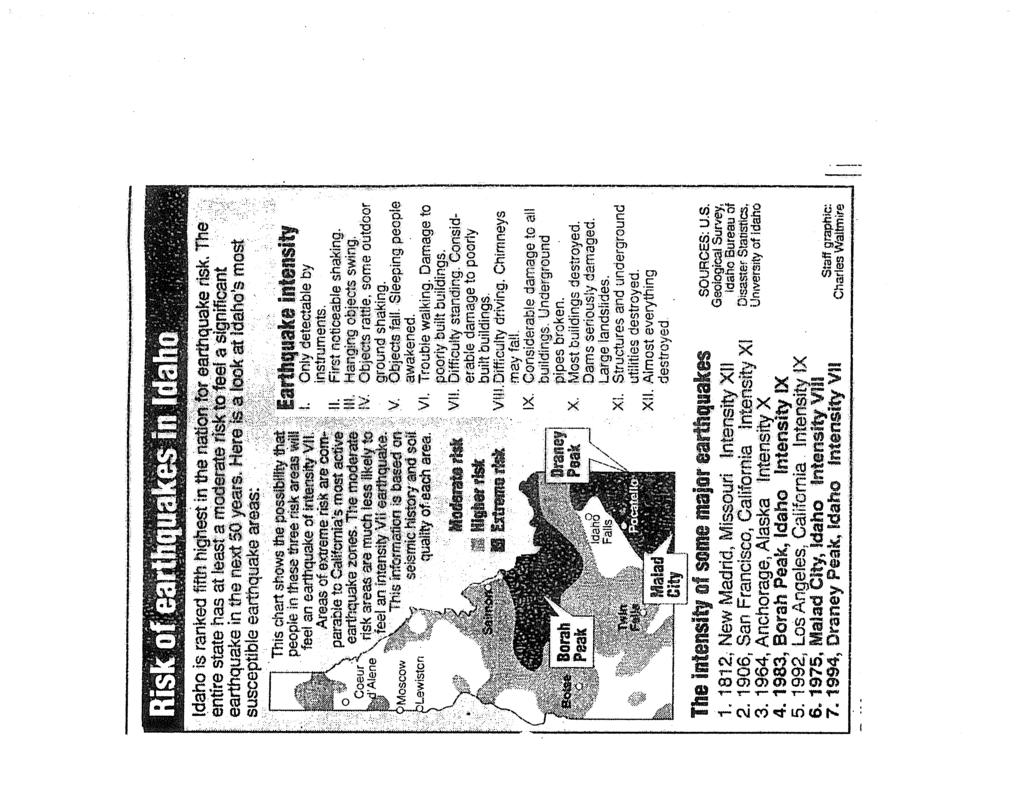
28 Teacher Notes for Borah Peak Activity Do this activity after students have completed the faults activity so they are already somewhat familiar with stress types and the basic fault types. Begin this activity with a series of slides which show some of the local faults. If possible, have them identify the hanging and foot walls, have them examine the relative motion of the blocks, and determine the possible stress type that was applied to create this type of movement. None of these slides is included in this activity but it would be beneficial to show some of your own which illustrate local examples of afore mentioned features. Follow this up with a slide show that was produced by Kurt Othberg and Roy Breckinridge which takes viewers through the setting, movement, and effects produced by the Borah Peak Earthquake in The original slide show and script have been modified into a Power Point presentation. It has been converted to a PDF file to ease the electronic transfer. This sets the stage well for the activity that follows. After viewing the slides (Power Point), take the students through the difference between an earthquakes magnitude (a measure of the size of the earthquake) and its intensity (a reflection of the damage produced by ground motion created by the earthquake). At this point, introduce students to the Modified Mercalli Scale. After highlighting the scale, show them an overhead with a map of the state of Idaho with selected locations highlighted. Then give them the list of accounts from these same cities. Their task is to match the observations up with the Mercalli Scale and record the intensity rating. This is a modification of an activity originally presented at a summer workshop at Mt. Borah by Kurt Othberg. This can be completed in a 47 min. class period. The following day, go over the results in class. By connecting points of equal seismic intensity, isoseismal lines (lines of equal seismic intensity) can be created. Then display for them an isoseismal map created with the data given. This allows geologists another view of the effects of an earthquake and insurance companies a way of flagging unusual reports of damage (not that anyone would ever be dishonest). End the follow-up activities by showing the Risk of earthquakes in Idaho overhead which ties them back into the Risk Map they created at the beginning of the unit (see Risk Map Activity ).
1. Why do earthquakes happen? 3. What type of mechanical waves are Primary or P waves? 4. What type of mechanical waves are Secondary or S waves?
 Name Period Earthquake Activity Background Information Earthquakes occur because of a sudden release of stored energy. This energy has built up over long periods of time as a result of tectonic forces
earthquakes 1. Earthquakes occur when plates grind against one another along cracks called faults.
 earthquakes BEGIN 1 earthquakes 1. Earthquakes occur when plates grind against one another along cracks called faults. 2 earthquakes 1. Earthquakes occur when plates grind against one another along cracks
EPS 20: Earthquakes. Laboratory Exercise 1. Intensity
 Name GSI Name EPS 20: Earthquakes Laboratory Exercise 1 Intensity Purpose: To investigate seismic intensity and how it is used to describe the effects of earthquakes Background: Several hundred years ago,
Earthquake. earthquake, epicenters in the U.S. Kobe, Japan deaths
 Kobe, Japan 1995 5000 deaths Earthquakes It is estimated that there are 500,000 detectable earthquakes in the world each year. 100,000 of those can be felt, and 100 of them cause damage. The world's deadliest
ENVI.2030L - Earthquakes
 ENVI.2030L - Earthquakes Name I. Introduction The crust of the earth behaves in a brittle manner. Stress is the force applied to a brittle substance and strain represents the build-up of energy in the
An earthquake can cause:
 Earthquakes An earthquake is a sudden rapid shaking of the earth. They are caused by the breaking and shifting of the rock beneath the earth s surface. Often found in conjunction with Plate tectonic boundaries.
Mw 7.8, Southwest of Sumatra, Indonesia Wed, 2 March 2016 at 12:49:48 UTC M /03/03
 Earthquake overview AFGHANISTA N PAKISTA N INDIA A moment magnitude (Mw) 7.8 earthquake struck in South West, Indonesia. The epicentre was centered about 800 km West South West of Padang, Sumatra province,
Magnitude 6.3, NORTH OF MOROCCO
 Earthquake location & overview A magnitude 6.3 earthquake struck in Alboran Sea, orth of Morocco; the epicentre was centered about 54 km ( 34 miles) E of Al Hoceima. The depth has been estimated to be
Released Science Inquiry Task Location Grade 11
 Date: Your Name: Released Science Inquiry Task Location 2009 Grade 11 Science Directions: You will be completing an extended-response inquiry task called Location. Explain the reasons for all of your answers.
Goals In this activity you will:
 Activity 3 How Big Was It? Goals In this activity you will: Rank the effects of earthquakes. Map the intensity of earthquakes. Interpret a map of earthquake intensity to infer the general location of the
II Seismic waves: Nearly- pure elasic waves
 MAGNITUDE AND INTENSITY (10) I Main Topics A Seismic waves B Magnitude C Intensity D Evernden s equaion for intensity decay 2/9/15 GG303 1 A Seismic waves 1 Cause damage 2 Provide quanitaive informaion
FOURTH GRADE HAZARDS 1 WEEK LESSON PLANS AND ACTIVITIES
 FOURTH GRADE HAZARDS 1 WEEK LESSON PLANS AND ACTIVITIES PLATE TECTONIC CYCLE OVERVIEW OF FOURTH GRADE VOLCANOES WEEK 1. PRE: Comparing different structures of volcanoes. LAB: Modeling three types of volcanoes.
appendix e: geologic and seismic hazards
 appendix e: geologic and seismic hazards CONTENTS: E-2 Fault Rupture E-3 Ground Shaking E-5 Seismic Ground Deformation E-5 Liquification E-6 Seismically Induces Landslide E-6 Landslide Hazard E The following
Basic Seismological Characterization for Goshen County, Wyoming
 Basic Seismological Characterization for Goshen County, Wyoming by James C. Case, Rachel N. Toner, and Robert Kirkwood Wyoming State Geological Survey September 2002 BACKGROUND Seismological characterizations
SECTION 3. Housing. EAppendix E GEOLOGIC AND SEISMIC HAZARDS
 SECTION 3 Housing EAppendix E GEOLOGIC AND SEISMIC HAZARDS E-2 Housing Commission Attachment B Appendix E Geologic and Seismic Hazards The following definitions provide a more comprehensive discussion
Earthquakes. Dr. Mark van der Meijde INTERNATIONAL INSTITUTE FOR GEO-INFORMATION SCIENCE AND EARTH OBSERVATION
 Earthquakes Dr. Mark van der Meijde vandermeijde@itc.nl INTERNATIONAL INSTITUTE FOR GEO-INFORMATION SCIENCE AND EARTH OBSERVATION Topics to handle Theory of earthquakes Mechanism Strength Measurements
Basic Seismological Characterization for Niobrara County, Wyoming
 Basic Seismological Characterization for Niobrara County, Wyoming by James C. Case, Rachel N. Toner, and Robert Kirkwood Wyoming State Geological Survey September 2002 BACKGROUND Seismological characterizations
Measuring the Size of an Earthquake
 Earthquake Hazard Information Hazard, Risk, Magnitude, Intensity, Earthquake Statistics Part 1 (Information for interpreting the results of building contest and shake table testing; L. Braile, 03/12/03)
Geologic Conditions. his section of the Background Report describes the existing conditions of the City of Elk Grove relative to Geologic Conditions.
 T his section of the Background Report describes the existing conditions of the City of Elk Grove relative to Geologic Conditions. Setting The Planning Area is located within the Great Valley geomorphic
Earthquakes and Earth s Chapter. Interior
 Earthquakes and Earth s Chapter Interior 8.1 What Is an Earthquake? An earthquake is the vibration of Earth produced by the rapid release of energy Focus and Epicenter Focus is the point within Earth
ESS 202. Landslide. Earthquake effects. ! Natural Hazards. More quake effects. ! Man-aided hazards. Stanford library in 1906
 ESS 202 Today: The Size of an Earthquake! Intensity! Magnitude! Moment House after tsunami, Brumbaugh 8-18 Earthquake effects! Natural Hazards " Ground shaking # Structural collapse # Falling objects "
Earthquake Damage Scenario
 Chapter 2. Earthquake Damage Scenario CHAPTER 2. EARTHQUAKE DAMAGE SCENARIO 2.1 Earthquake Scenario Setting and Ground Motion 2.1.1 Fault in the Philippines The Philippines is located in latitude 5 to
IV. ENVIRONMENTAL IMPACT ANALYSIS F. GEOLOGY AND SOILS
 IV. ENVIRONMENTAL IMPACT ANALYSIS F. GEOLOGY AND SOILS INTRODUCTION This section of the DEIR evaluates potential impacts to the project site s geologic environment that may result from implementation of
20.1 Earthquakes. Chapter 20 EARTHQUAKES AND VOLCANOES. Earthquakes and plate boundaries 500 UNIT 6 EARTH S STRUCTURE
 Chapter 20 EARTHQUAKES AND VOLCANOES 20.1 Earthquakes In Chapter 19, you read about the San Andreas Fault, which lies along the California coast (Figure 20.1). This fault passes right through San Francisco
Dynamic Crust Regents Review
 Name Dynamic Crust Regents Review Base your answers to questions 1 through 3 on the table below, which lists the location of some earthquakes, their Richter magnitude, and their year of occurrence. Data
Introduction to Engineering Seismology
 Introduction to Engineering Seismology Sudhir K Jain Mythology The Myths 2 The Earth is held up by 4 elephants that stand on the back of a turtle. The turtle is balanced in turn on a cobra. When any of
C2.2 The physics of Earthquakes
 C2.2 The physics of Earthquakes C2.2.1 Stress axes and faults Most earthquakes occur because of the mechanical failure on brittle faults. The type of faulting is a consequence of the stress pattern causing
Three Fs of earthquakes: forces, faults, and friction. Slow accumulation and rapid release of elastic energy.
 Earthquake Machine Stick-slip: Elastic Rebound Theory Jerky motions on faults produce EQs Three Fs of earthquakes: forces, faults, and friction. Slow accumulation and rapid release of elastic energy. Three
dt r = 0 sin i 0 = P d Δ V 0
 dt dδ = r 0 sin i 0 V 0 = P sin i toa Me Always someone needs to reorder and make difficult to check Me One that agrees with me many don t though many agree with each other science begins Locating Local
Course Outline (1) 2. Engineering Seismology. #2 Engineering Seismology
 2. Engineering Seismology. #2 Engineering Seismology") CE3.98N Soil Dynamics and Earthquake Engineering # Engineering Seismology January 15, 3 Fumio Yamazaki yamazaki@ait.ac.th http://www.sce.ait.ac.th/people/faculty/~yamazaki SEC/SCE, AIT. 1 1. Introduction
CE3.98N Soil Dynamics and Earthquake Engineering # Engineering Seismology January 15, 3 Fumio Yamazaki yamazaki@ait.ac.th http://www.sce.ait.ac.th/people/faculty/~yamazaki SEC/SCE, AIT. 1 1. Introduction
Technical Considerations Associated with Risk Management of Induced Seismicity in Waste-Water Disposal & Hydraulic Fracturing Operations
 Technical Considerations Associated with Risk Management of Induced Seismicity in Waste-Water Disposal & Hydraulic Fracturing Operations K. J. (Kris) Nygaard, Sr. Stimulation Consultant ExxonMobil Production
Section 19.1: Forces Within Earth Section 19.2: Seismic Waves and Earth s Interior Section 19.3: Measuring and Locating.
 CH Earthquakes Section 19.1: Forces Within Earth Section 19.2: Seismic Waves and Earth s Interior Section 19.3: Measuring and Locating Earthquakes Section 19.4: Earthquakes and Society Section 19.1 Forces
Identifying the causes and effects of earthquakes
 Science 3 Physical Earth and Space Life LESSON 57 Identifying the causes and effects of earthquakes Lesson Preparation Program Materials Child s Booklet E Exploring the Earth s Structure (pp. 12 13) Optional:
Monday 11 May 2015 Morning
 Oxford Cambridge and RSA Monday 11 May 2015 Morning AS GCE GEOLOGY F791/01 Global Tectonics *5003095113* Candidates answer on the Question Paper. OCR supplied materials: None Other materials required:
Basic Seismological Characterization for Sheridan County, Wyoming
 Basic Seismological Characterization for Sheridan County, Wyoming by James C. Case, Rachel N. Toner, and Robert Kirkwood Wyoming State Geological Survey September 2002 BACKGROUND Seismological characterizations
Forces in Earth s Crust
 Name Date Class Earthquakes Section Summary Forces in Earth s Crust Guide for Reading How does stress in the crust change Earth s surface? Where are faults usually found, and why do they form? What land
Earthquakes An introduction to earthquake monitoring techniques
 Earthquakes An introduction to earthquake monitoring techniques TEACHER S COPY Aims To understand what an earthquake is and where they occur To gain an insight into how earthquakes are recorded and how
Earthquakes. Earthquakes and Plate Tectonics. Earthquakes and Plate Tectonics. Chapter 6 Modern Earth Science. Modern Earth Science. Section 6.
 Earthquakes Chapter 6 Modern Earth Science Earthquakes and Plate Tectonics Section 6.1 Modern Earth Science Earthquakes and Plate Tectonics Earthquakes are the result of stresses in Earth s s lithosphere.
An entire branch of Earth science, called, is devoted to the study of earthquakes.
 Lesson One Essential Question Where do earthquakes take place? What causes earthquakes? What are three different types of faults that occur at plate boundaries? How does energy from earthquakes travels
EARTHQUAKES AND EARTHQUAKE-RESISTANT DESIGN OF STRUCTURES. Er. K. S. BHARGAV LECTURER Department of Civil Engineering, GGSGP CHEEKA
 EARTHQUAKES AND EARTHQUAKE-RESISTANT DESIGN OF STRUCTURES by Er. K. S. BHARGAV LECTURER Department of Civil Engineering, GGSGP CHEEKA SCOPE OF PRESENTATION EARTHQUAKE AND ITS CHARACTERIZATION EARTHQUAKE-RESISTANT
Earthquakes. These icons indicate that teacher s notes or useful web addresses are available in the Notes Page.
 Earthquakes These icons indicate that teacher s notes or useful web addresses are available in the Notes Page. This icon indicates the slide contains activities created in Flash. These activities are not
1 of 27. Boardworks Ltd Earthquakes
 1 of 27 Earthquakes Teacher s notes and Flash files Most slides contain notes to accompany the presentation. This icon indicates that the notes contain particularly detailed instructions or extension activities.
I. What are Earthquakes?
 I. What are Earthquakes? A. There is more to earthquakes than just the shaking of the ground. An entire branch of Earth science, called seismology, is devoted to the study of earthquakes. B. Earthquakes
P A R T 1 INTRODUCTION TO EARTHQUAKES
 P A R T 1 INTRODUCTION TO EARTHQUAKES CHAPTER 2 BASIC EARTHQUAKE PRINCIPLES The following notation is used in this chapter: SYMBOL DEFINITION a max Maximum horizontal acceleration at the ground surface
Figure 12.1: The 1964 Alaska earthquake was the longest ever recorded and the largest ever recorded in the United States.
 12.1 Earthquakes In a place where earthquakes are common, it is not unusual to feel the ground shake. You might notice tiny ripples in your juice glass at breakfast and then you might feel small vibrations
Information for this section has been provided by Wyoming State Geological Survey (WSGS).
.") Chapter 11: Earthquakes POTENTIAL, AND IMPACTS Information for this section has been provided by Wyoming State Geological Survey (WSGS). Fremont County has experienced damaging earthquakes in the past
Chapter 11: Earthquakes POTENTIAL, AND IMPACTS Information for this section has been provided by Wyoming State Geological Survey (WSGS). Fremont County has experienced damaging earthquakes in the past
Section Forces Within Earth. 8 th Grade Earth & Space Science - Class Notes
 Section 19.1 - Forces Within Earth 8 th Grade Earth & Space Science - Class Notes Stress and Strain Stress - is the total force acting on crustal rocks per unit of area (cause) Strain deformation of materials
Natural Disasters Spring, LECTURE #8: Earthquake Disasters: Monitoring & Mitigation. Date: 1 Feb 2018 (lecturer: Dr.
 GEOL 0820 Ramsey Natural Disasters Spring, 2018 LECTURE #8: Earthquake Disasters: Monitoring & Mitigation Date: 1 Feb 2018 (lecturer: Dr. Shawn Wright) I. Exam I - Reminder Feb 6 th next class details:
Names: ESS 315 Lab # 1 Seismic Hazards along the Cascadia Subduction Zone
 Names: ESS 315 Lab # 1 Seismic Hazards along the Cascadia Subduction Zone 1 Seismographs located throughout the Pacific Northwest record thousands of earthquakes each year in Washington and Oregon. Between
Directed Reading. Section: How and Where Earthquakes Happen WHY EARTHQUAKES HAPPEN. Skills Worksheet. 1. Define earthquake.
 Skills Worksheet Directed Reading Section: How and Where Earthquakes Happen 1. Define earthquake. 2. When do earthquakes usually occur? 3. What is a fault? WHY EARTHQUAKES HAPPEN 4. Rocks along both sides
Earthquakes and Earth s Interior
 - What are Earthquakes? Earthquakes and Earth s Interior - The shaking or trembling caused by the sudden release of energy - Usually associated with faulting or breaking of rocks - Continuing adjustment
The Size of an Earthquake. Intensity of Shaking (Robert Mallet, 1857) Calculation of Earthquake Magnitude (Charles Richter, 1935)
 Calculation of Earthquake Magnitude (Charles Richter, 1935)") The Size of an Earthquake Intensity of Shaking (Robert Mallet, 1857) Calculation of Earthquake Magnitude (Charles Richter, 1935) In 1857, Robert Mallet produced isoseismal lines based on quantified damage
The Size of an Earthquake Intensity of Shaking (Robert Mallet, 1857) Calculation of Earthquake Magnitude (Charles Richter, 1935) In 1857, Robert Mallet produced isoseismal lines based on quantified damage
Earthquakes. Chapter Test A. Multiple Choice. Write the letter of the correct answer on the line at the left.
 Earthquakes Chapter Test A Multiple Choice Write the letter of the correct answer on the line at the left. 1. Stress that pushes a mass of rock in two opposite directions is called a. shearing. b. tension.
Earthquakes & Volcanoes
 Earthquakes & Volcanoes Geology - the study of solid Earth, the rocks of which it is composed, and the processes by which they change geo = Earth; ology = study of Earth s Layers Plate Tectonics - the
Magnitude 6.3 SOUTH ISLAND OF NEW ZEALAND
 A magnitude 6.3 earthquake shook the southern New Zealand city of Christchurch. At least 100 people are reported dead, and there are reports of collapsed buildings, cracked streets and flooding due to
Landslide Mitigation (BYUI)
") Landslide Mitigation (BYUI) The general principle behind landslide mitigation is stabilization. Slopes that are too steep are shallowed or strengthened. Loose rocks can be bolted or cemented into place.
Landslide Mitigation (BYUI) The general principle behind landslide mitigation is stabilization. Slopes that are too steep are shallowed or strengthened. Loose rocks can be bolted or cemented into place.
Forces in the Earth s crust
 EARTHQUAKES Forces in the Earth s crust How does stress in the crust change Earth s surface? Where are faults usually found, and why do they form? What land features result from the forces of plate movement?
Preliminary Damage Report of the August 22, 2011 Mw 5.3 Earthquake near Trinidad, Colorado
 Preliminary Damage Report of the August 22, 2011 Mw 5.3 Earthquake near Trinidad, Colorado Matthew L. Morgan and Karen S. Morgan Colorado Geological Survey At 11:46 PM MDT on August 22, 2011, a Mw 5.3
Before exploring the effects of the 1906 earthquake, watch the video on ground shaking and liquefaction at:
 Seismic Risk: Pre- Work Paper Maps Version Early on the morning of April 16, 1906, a magnitude 7.8 earthquake struck on the San Andreas Fault. The 1906 San Francisco earthquake revolutionized our understanding
UGRC 144 Science and Technology in Our Lives/Geohazards
 UGRC 144 Science and Technology in Our Lives/Geohazards Session 3 Understanding Earthquakes and Earthquake Hazards Lecturer: Dr. Patrick Asamoah Sakyi Department of Earth Science, UG Contact Information:
Seismic Waves. 1. Seismic Deformation
 Types of Waves 1. Seismic Deformation Seismic Waves When an earthquake fault ruptures, it causes two types of deformation: static; and dynamic. Static deformation is the permanent displacement of the ground
Earthquakes. Copyright 2006 InstructorWeb
 Earthquakes Earthquakes cause the earth to shake! Earthquakes are caused by a fault line under the earth's crust. You do not have to be right under a fault line to feel an earthquake. You could be miles
Tornadoes. Tornadoes COMMUNITY EMERGENCY RESPONSE TEAM TORNADOES
 Tornadoes Tornadoes Tell the participants that tornadoes are powerful, circular windstorms that may be accompanied by winds in excess of 200 miles per hour. Tornadoes typically develop during severe thunderstorms
Basic Seismological Characterization for Fremont County, Wyoming
 Basic Seismological Characterization for Fremont County, Wyoming by James C. Case, Rachel N. Toner, and Robert Kirkwood Wyoming State Geological Survey September 2002 BACKGROUND Seismological characterizations
11/30/16 EARTHQUAKES ELASTIC LIMIT FAULT FORCE AND PLATES WHAT DO YOU NOTICE?
 ELASTIC LIMIT EARTHQUAKES Bend sitck but do not break it. What do you notice? No bend until it breaks. Describe the energy and forces at work. (Kinetic, potential etc) 8 TH GRADE FAULT FORCE AND PLATES
EARTHQUAKE STATISTICS FOR OHIO 1
 EARTHQUAKE STATISTICS FOR OHIO 1 EDMUND F. PAWLOWICZ Seismological Observatory, Department of Geology, Bowling Green State Bowling Green, Ohio 434-03 University, PAWLOWICZ, EDMUND F. Earthquake statistics
EARTH S PROCESSES VOCABULARY
 EARTH S PROCESSES VOCABULARY Divergent Convergent Subduction Transform Ring of Fire Earthquake Stress Strain Fault Primary Waves Secondary Waves Surface Waves Focus Epicenter Seismology Magnitude Richter
Slide 1. Earth Science. Chapter 5 Earthquakes
 Slide 1 Earth Science Chapter 5 Earthquakes Slide 2 Forces in Earth's Crust A force that acts on rock to change its shape or volume is stress 3 types of stress acting on rock layers Tension pulls on the
Induced Seismicity: Can it Happen in Kentucky Too?
 Induced Seismicity: Can it Happen in Kentucky Too? Seth Carpenter Seismologist Geologic Hazards Section 2015 KGS Annual Seminar Outline - What s the problem? - Earthquake magnitude - Types of induced seismic
Analysis of NYS Earthquake
 Analysis of NYS Earthquake NAME INTRODUCTION An earthquake s strength depends on how much of the energy stored in the rocks is released. There are two methods of identifying the intensity of an earthquake.
(First Edition: prepared on 29/12/2003)
") (First Edition: prepared on 29/12/2003) Dr Sassan Eshghi 1 and Dr Mehdi Zaré 2 International Institute of Earthquake Engineering and Seismology, Tehran, P.O.Box: 19395/3913, IRAN e-mails: 1)s.eshghi@iiees.ac.ir,
(First Edition: prepared on 29/12/2003) Dr Sassan Eshghi 1 and Dr Mehdi Zaré 2 International Institute of Earthquake Engineering and Seismology, Tehran, P.O.Box: 19395/3913, IRAN e-mails: 1)s.eshghi@iiees.ac.ir,
Important Concepts. Earthquake hazards can be categorized as:
 Lecture 1 Page 1 Important Concepts Monday, August 17, 2009 1:05 PM Earthquake Engineering is a branch of Civil Engineering that requires expertise in geology, seismology, civil engineering and risk assessment.
Earthquakes. Beyond the Book. FOCUS Book
 FOCUS Book Model how liquefaction during an earthquake changes Earth s surface and affects buildings. Put sand in a large plastic container. Mix enough water into the sand to make the ground feel firm.
Earthquake Leaflet What to do if you experience a strong Earthquake
 Earthquake Leaflet What to do if you experience a strong Earthquake Prepared by Prof. Peter Bormann This leaflet provides basic information for those citizens who may have temporary or long-term stays
Earthquake hazards. Aims 1. To know how hazards are classified 2. To be able to explain how the hazards occur 3. To be able to rank order hazards
 Earthquake hazards Aims 1. To know how hazards are classified 2. To be able to explain how the hazards occur 3. To be able to rank order hazards Types of hazard Primary A direct result of the earthquake
COMMUNITY EMERGENCY RESPONSE TEAM TORNADOES
 Tornadoes are powerful, circular windstorms that may be accompanied by winds in excess of 200 miles per hour. Tornadoes typically develop during severe thunderstorms and may range in width from several
4.5 GEOLOGY AND SOILS
 4.5.1 INTRODUCTION This resource section evaluates the potential environmental effects related to geology and soils from implementation of. The analysis includes a review of regional geology, seismicity
Tornadoes pose a high risk because the low atmospheric pressure, combined with high wind velocity, can:
 Tornadoes are powerful, circular windstorms that may be accompanied by winds in excess of 200 miles per hour. Tornadoes typically develop during severe thunderstorms and may range in width from several
ENGINEER S CERTIFICATION OF FAULT AREA DEMONSTRATION (40 CFR )
") PLATTE RIVER POWER AUTHORITY RAWHIDE ENERGY STATION BOTTOM ASH TRANSFER (BAT) IMPOUNDMENTS LARIMER COUNTY, CO ENGINEER S CERTIFICATION OF FAULT AREA DEMONSTRATION (40 CFR 257.62) FOR COAL COMBUSTION RESIDUALS
PLATTE RIVER POWER AUTHORITY RAWHIDE ENERGY STATION BOTTOM ASH TRANSFER (BAT) IMPOUNDMENTS LARIMER COUNTY, CO ENGINEER S CERTIFICATION OF FAULT AREA DEMONSTRATION (40 CFR 257.62) FOR COAL COMBUSTION RESIDUALS
Earthquakes.
 Earthquakes http://quake.usgs.gov/recenteqs/latestfault.htm An earthquake is a sudden motion or shaking of the Earth's crust, caused by the abrupt release of stored energy in the rocks beneath the surface.
Induced Seismicity Risks
 Induced Seismicity Risks Maurice Dusseault Earthquakes Natural Earthquakes Geotectonic Earthquake Ocean Earthquake tsunami Volcanic Eruption Induced Seismicity Tidal Triggering of Earthquake Man-made Earthquakes
IN VEHICLES: Do not try to outrun a tornado. Abandon your vehicle and hide in a nearby ditch or depression and cover your head.
 TORNADO SAFETY TORNADO! The very word strikes fear in many people. While a tornado is perhaps nature's most destructive storm, deaths and injuries can be prevented. By following Tornado Safety Rules, lives
Chapter: Earthquakes and Volcanoes
 Table of Contents Chapter: Earthquakes and Volcanoes Section 1: Earthquakes Section 2: Volcanoes Section 3: Earthquakes, Volcanoes, and Plate Tectonics 1 Earthquakes What causes earthquakes? Elastic Rebound
Earthquakes Science & Safety. Ms Joan L. Latchman Seismologist Seismic Research Unit
 Earthquakes Science & Safety Ms Joan L. Latchman Seismologist Seismic Research Unit Summary Trinidad lies in an area of high earthquake activity for the Caribbean. Earthquake safety tips should be practiced
7.3 Magnitude Earthquake Strikes Iran-Iraq Border
 7.3 Magnitude Earthquake Strikes Iran-Iraq Border KEY POINTS A magnitude 7.3 earthquake has struck the Iran-Iraq border with at least 348 fatalities reported. Thousands more have been injured and many
Rapid Changes on Earth: Earthquakes, Volcanoes, Landslides. Chapter 6 Study Guide
 Rapid Changes on Earth: Earthquakes, Volcanoes, Landslides Chapter 6 Study Guide Magma is 1. The point underground where an earthquake starts. 2. Molten rock beneath the Earth s surface. 3. Molten rock
Earthquake lesson plan
 Earthquake lesson plan The earthquake lesson plan provides teachers and students with an opportunity to investigate the 1989 Newcastle earthquake through individual or classroom activities. ITEMS Teachers
Chapter 6: Earthquakes
 Section 1 (Forces in Earth s Crust) Chapter 6: Earthquakes 8 th Grade Stress a that acts on rock to change its shape or volume Under limited stress, rock layers can bend and stretch, but return to their
Processes and Impact of Natural Hazards
 The Big Island of Hawaii is the largest of the Hawaiian Islands. It is also home to a very active volcano. The Kilauea volcano has been active since 1983. The lava that flows from the Kilauea volcano has
Earthquakes and Seismic Waves Lesson 4 2
 Earthquakes and Seismic Waves Lesson 4 2 Apr 15 8:52 PM What are seismic waves? How are earthquakes measured? How is an earthquake located? Apr 15 8:54 PM 1 What are seismic waves An earthquake is the
How to Use This Presentation
 How to Use This Presentation To View the presentation as a slideshow with effects select View on the menu bar and click on Slide Show. To advance through the presentation, click the right-arrow key or
BUREAU OF MINERAL RESOURCES GEOLOGY AND GEOPHYSICS
 681// (3) COMMONWEALTH OF AUSTRALIA DEPARTMENT OF NATIONAL DEVELOPMENT BUREAU OF MINERAL RESOURCES GEOLOGY AND GEOPHYSICS RECORDS: %ICIER RECORD NO. 1968/11 IBRARY ra 1 7J UN 1968 ref: SEISMICITY OF BOUGAINVILLE,
Earthquakes. Building Earth s Surface, Part 2. Science 330 Summer What is an earthquake?
 Earthquakes Building Earth s Surface, Part 2 Science 330 Summer 2005 What is an earthquake? An earthquake is the vibration of Earth produced by the rapid release of energy Energy released radiates in all
Chapter 11 10/30/2013. Mass Wasting. Introduction. Factors That Influence Mass Wasting. Introduction. Factors That Influence Mass Wasting
 Introduction Chapter 11 Mass wasting - The downslope movement of material resulting from the force of gravity. Mass Wasting Mass wasting results when the force of gravity acting on a slope exceeds the
Earthquakes Science & Safety. Dr. Richard Robertson Geologist & Head Seismic Research Unit
 Earthquakes Science & Safety Dr. Richard Robertson Geologist & Head Seismic Research Unit Summary The Eastern Caribbean islands are in a seismically active part of the world. Earthquake safety tips should
GEOLOGY MEDIA SUITE Chapter 13
 UNDERSTANDING EARTH, SIXTH EDITION GROTZINGER JORDAN GEOLOGY MEDIA SUITE Chapter 13 Earthquakes 2010 W.H. Freeman and Company Three different types of seismic waves are recorded by seismographs Key Figure
TORNADOES. DISPLAY VISUAL A Tornado Is... Tornadoes can: Rip trees apart. Destroy buildings. Uproot structures and objects.
 TORNADOES Introduce tornadoes by explaining what a tornado is. DISPLAY VISUAL A Tornado Is... A powerful, circular windstorm that may be accompanied by winds in excess of 250 miles per hour. Tell the participants
Earthquakes and Earthquake Hazards Earth - Chapter 11 Stan Hatfield Southwestern Illinois College
 Earthquakes and Earthquake Hazards Earth - Chapter 11 Stan Hatfield Southwestern Illinois College What Is an Earthquake? An earthquake is the vibration of Earth, produced by the rapid release of energy.
on the earthquake's strength. The Richter scale is a rating of an earthquake s magnitude based on the size of the
 Earthquakes and Seismic Waves An earthquake is the shaking and trembling that results from the movement of rock beneath Earth's surface. The point beneath Earth s surface where rock under stress breaks
SOME LOCAL EFFECTS OF THE SAN FRANCISCO EARTHQUAKE
 SOME LOCAL EFFECTS OF THE SAN FRANCISCO EARTHQUAKE STEPHEN TABER Leland Stanford Junior University The principal damage done by the San Francisco earthquake of April 18, 1906, was confined to a long, narrow