Earthquake and Tsunami Modeling in Japan. Renee Lee Product Manager, RMS
|
|
|
- Brenda Hodges
- 6 years ago
- Views:
Transcription
1 Earthquake and Tsunami Modeling in Japan Renee Lee Product Manager, RMS

2 RMS JAPAN EARTHQUAKE MODEL HISTORY

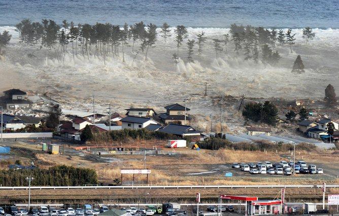
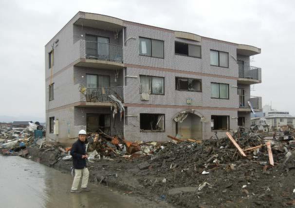
3 2011 GREAT EAST JAPAN EARTHQUAKE M9.0
4 SCOPE OF JAPAN EARTHQUAKE MODEL UPDATE (2012) Event Rate Reassessment Updates to stochastic event rates Inclusion of long-term event rates Seismic Source Considerations New subduction interface sources Additional large megathrust events on the Nankai Trough Tsunami Accumulation Footprints Inundation from the 2011 Great East Japan (Tohoku) Earthquake Inundation from scenarios on the Nankai Trough Ground Motion Footprint Ground motion footprint for the 2011 Great East Japan (Tohoku) Earthquake ALM Profile Update ALM profiles recompiled to reflect new stochastic event rates ILC Update Industry Loss Curves (ILCs) to reflect updated stochastic event rates 2014 Risk Management Solutions, Inc. Confidential

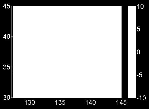
5 UPDATES TO THE JAPANESE NATIONAL SEISMIC HAZARD MAPS ERC 2012 map: Probability for seismic intensity 6 Lower or More within 30 years (average case)


6 COMBINING RESEARCH WITH NEW SCIENCE AND DATA Hazard Maps and Lessons Learned Methodological Improvements RMS RESEARCH NEW DATA AND SCIENCE Geocoding/ Hazard Vulnerability Financial Exposure
7 SECONDARY HAZARDS

8


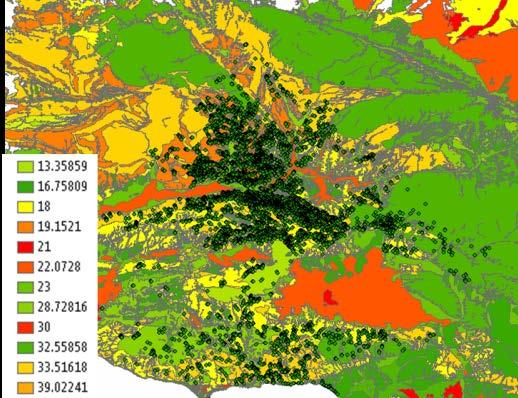
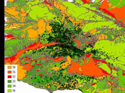
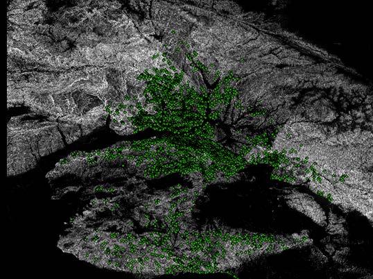
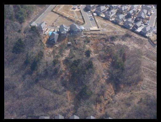
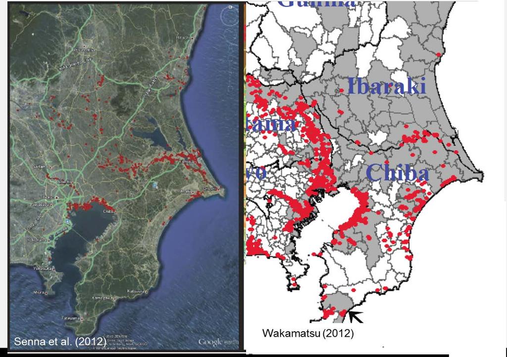
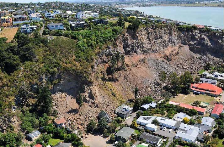
9 ENHANCING LANDSLIDE MODELING Friction Cohesion Slope Rainfall Vegetation Landslides
10 Source:
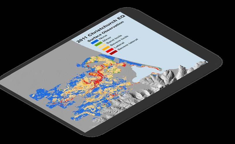
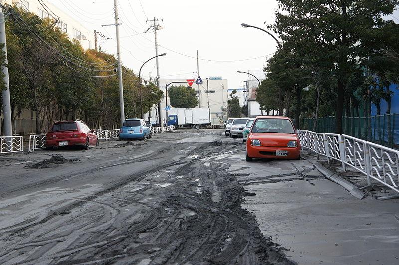
11 ENHANCING LIQUEFACTION MODELING Source: NBC News
12 SUBPERIL TSUNAMI
13 TSUNAMI Ref:


14 TSUNAMI MODELING OVERVIEW Event Generation Wave Propagation Coastal Inundation
 Image: S.")
15 EVENT GENERATION Generalized representation of a M9 Japan Trench Image: C. Williams (2013) Image: S. Astill et al (2013)


16 WAVE PROPAGATION Initial condition is the surface deformation Maximum wave height (meters) over mean sea level (MSL Image: R. Farahani et al (2013)


17 COASTAL INUNDATION High resolution DTMs Friction coefficients based on global land cover characteristics Images: Shuangcai Li, Fahad Mohammed, and Rozita Farahani (2014)


18 VALIDATION 2014 Risk Management Solutions, Inc. Confidential
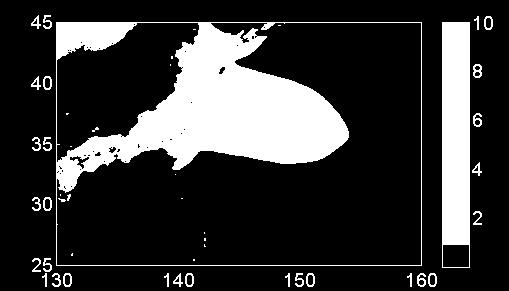
19 TSUNAMI IMPACTS OF A M9 ON NANKAI TROUGH

20 NANKAI TROUGH M9.0 - SCENARIO Surface Deformation Source Characterization Image: C. Williams (2013) Image: S. Astill et al (2013)


21 NANKAI TROUGH M9.0 - SCENARIO Basin-wide Wave Propagation


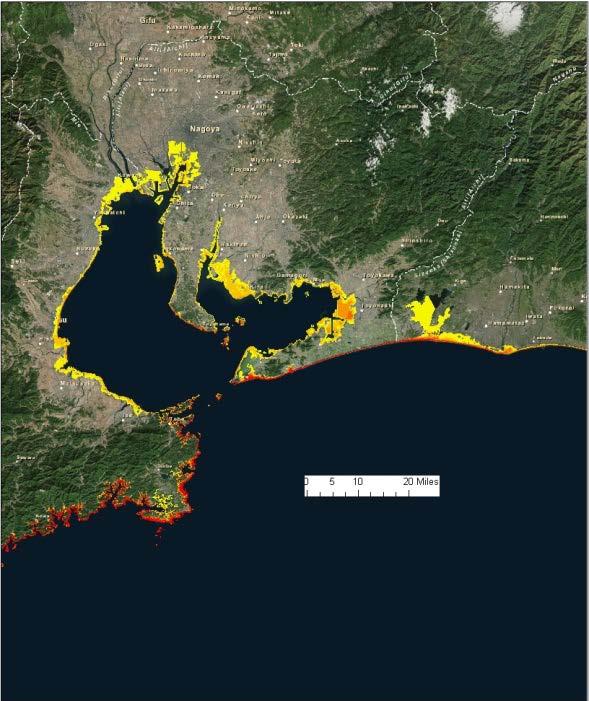

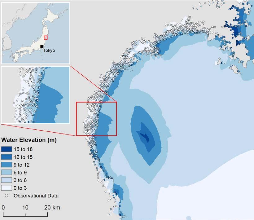
22 NANKAI TROUGH M9.0 - SCENARIO Coastal Inundation Tanabe, Japan Nagoya, Japan


23 NANKAI TROUGH M9.0 - SCENARIO Konan, Kochi Prefecture Inundation Depth m m m m m > 9.0m
24 VULNERABILITY

25 VULNERABILITY for Liquefaction and Landslide New Vulnerability Functions for Tsunami
26 DEVELOPING ROBUST VULNERABILITY CURVES Data Vulnerability Function Expert Opinion Simulation Based on Science & Engineering
27 damage ratio DEVELOPING ROBUST VULNERABILITY CURVES MDR mean vulnerability function MDR EDP Engineering Demand Parameter aa FFFF Updating Contents Functions IFM Updating BI Functions Add Builders Risk to HD EQ Add new classifications, e.g. Cargo SS dd TT 1 = ss dd hazard intensity measure uu gg IM EDP Intensity Measure
28 NEXT GENERATION OF JAPAN EARTHQUAKE MODEL Data Driven Approaches & Enhanced Modeling Capabilities
STRESS IN THE SYSTEM? INSIGHTS INTO MODELLING IN THE WAKE OF TOHOKU
 STRESS IN THE SYSTEM? INSIGHTS INTO MODELLING IN THE WAKE OF TOHOKU Aspen Re June 13, 2012 James Few President, Aspen Re Aspen Insurance Holdings Limited AGENDA Do we need near-term quake rates? Lessons
KNOWLEDGE NOTE 5-1. Risk Assessment and Hazard Mapping. CLUSTER 5: Hazard and Risk Information and Decision Making. Public Disclosure Authorized
 Public Disclosure Authorized Public Disclosure Authorized Public Disclosure Authorized Public Disclosure Authorized KNOWLEDGE NOTE 5-1 CLUSTER 5: Hazard and Risk Information and Decision Making Risk Assessment
Cascadia megathrust earthquakes: reducing risk through science, engineering, and planning
 Cascadia megathrust earthquakes: reducing risk through science, engineering, and planning NSF Hazards SEES EAR-1331412 Urban Science and Engineering Workshop 21 July 2014 Everything to do with M9 Cascadia
How to communicate Cascadia Subduction Zone earthquake hazards
 How to communicate Cascadia Subduction Zone earthquake hazards Tom Brocher Research Geophysicist Earthquake Science Center U.S. Geological Survey Menlo Park, California Seattle Post-Intelligencer Lessons
Real Time Monitoring System for Megathrust Earthquakes and Tsunamis - Cabled Network System and Buoy System in Japan -
 Real Time Monitoring System for Megathrust Earthquakes and Tsunamis - Cabled Network System and Buoy System in Japan - 1 Subduction zones around the world Haiti Italy Turkey Tohoku Sichuan Taiwan Sumatra
Probabilistic Tsunami Hazard Assessment addressing the uncertainty of tsunami source
 Probabilistic Tsunami Hazard Assessment addressing the uncertainty of tsunami source Pacific Rim Forum 2017 January 23, 2017 Yuta Abe, ITOCHU Techno-Solutions Corporation, Japan Copyright (c)2017 ITOCHU
Seismic Activity and Crustal Deformation after the 2011 Off the Pacific Coast of Tohoku Earthquake
 J-RAPID Symposium March 6-7, 2013 Seismic Activity and Crustal Deformation after the 2011 Off the Pacific Coast of Tohoku Earthquake Y. Honkura Tokyo Institute of Technology Japan Science and Technology
GROUND MOTION SPECTRAL INTENSITY PREDICTION WITH STOCHASTIC GREEN S FUNCTION METHOD FOR HYPOTHETICAL GREAT EARTHQUAKES ALONG THE NANKAI TROUGH, JAPAN
 GROUND MOTION SPECTRAL INTENSITY PREDICTION WITH STOCHASTIC GREEN S FUNCTION METHOD FOR HYPOTHETICAL GREAT EARTHQUAKES ALONG THE NANKAI TROUGH, JAPAN Masayuki YOSHIMI 1, Yasuto KUWAHARA 2, Masayuki YAMADA
Approach of Estimating Tsunami Economic Losses in The. Okinawa Island with Scenario-based of Input-Output Table. and Okinawa Earthquake Sources
 ORIGINAL ARTICLE Approach of Estimating Tsunami Economic Losses in The Okinawa Island with Scenario-based of Input-Output Table and Okinawa Earthquake Sources Kwanchai Pakoksung 1*, Anawat Suppasri 1,
Earthquake Hazards. Tsunami
 Earthquake Hazards Tsunami Measuring Earthquakes Two measurements that describe the power or strength of an earthquake are: Intensity a measure of the degree of earthquake shaking at a given locale based
Earthquake Hazards. Tsunami
 Earthquake Hazards Tsunami Review: What is an earthquake? Earthquake is the vibration (shaking) and/or displacement of the ground produced by the sudden release of energy. The point inside the Earth where
Wainui Beach Management Strategy (WBMS) Summary of Existing Documents. GNS Tsunami Reports
 Summary of Existing Documents. GNS Tsunami Reports") Wainui Beach Management Strategy (WBMS) Summary of Existing Documents GNS Tsunami Reports a) Review of Tsunami Hazard and Risk in New Zealand ( National Risk Report ) b) Review of New Zealand s Preparedness
Wainui Beach Management Strategy (WBMS) Summary of Existing Documents GNS Tsunami Reports a) Review of Tsunami Hazard and Risk in New Zealand ( National Risk Report ) b) Review of New Zealand s Preparedness
Coseismic slip model
 Figure 3 - Preliminary highly smoothed model of coseismic slip for the 11 March UCL Institute for Risk & Disaster Reduction Magnitude 9.0 (JMA scale) earthquake Occurred at 02:46:23 pm local time near
RAPSODI Risk Assessment and design of Prevention Structures for enhanced tsunami DIsaster resilience
 RAPSODI Risk Assessment and design of Prevention Structures for enhanced tsunami DIsaster resilience Possible NGI contributions related to tsunami modelling activities Finn Løvholt and Carl B. Harbitz
Structures Group Report
 Structures Group Report Ian Buckle, Co-leader University of Nevada Reno Kazuhiko Kawashima, Co-leader Tokyo Institute of Technology J-RAPID Final Symposium, Sendai, March 6-7, 2013 Structures Presentations
What Are Disasters? The Rescue Kids Trio!
 The Rescue Kids Trio! What Are Disasters? This manual was made possible through funding by the Council of Local Authorities for International Relations. Disasters and emergency preparedness Emergency preparedness
REPORT ON THE TOHOKU AREA PASIFIC OFFSHORE EARTHQUAKE
 REPORT ON THE TOHOKU AREA PASIFIC OFFSHORE EARTHQUAKE GENERAL PERSPECTIVE The Highest Magnitude Ever Recorded The 2011 off the Pacific Coast of Tohoku Earthquake (hereafter, the 2011 Tohoku- Pacific Earthquake
APPLICATON OF SEAMLESS SIMULATION OF SEISMIC RESPONSE ANALYSIS AND HIGH RESOLUTION TSUNAMI SIMULATION TO COASTAL AREA OF SENDAI
 Proceedings of the International Symposium on Engineering Lessons Learned from the 2011 Great East Japan Earthquake, March 1-4, 2012, Tokyo, Japan APPLICATON OF SEAMLESS SIMULATION OF SEISMIC RESPONSE
Predicting tsunami waves and currents on the West Coast of Canada: A case study for Ucluelet, BC
 Predicting tsunami waves and currents on the West Coast of Canada: A case study for Ucluelet, BC Josef Cherniawsky, Kelin Wang and Roy Walters Institute of Ocean Sciences, Fisheries & Oceans Canada Pacific
Earthquake Source. Kazuki Koketsu. Special Session: Great East Japan (Tohoku) Earthquake. Earthquake Research Institute, University of Tokyo
 Earthquake. Earthquake Research Institute, University of Tokyo") 2012/9/24 17:20-17:35 WCEE SS24.4 Special Session: Great East Japan (Tohoku) Earthquake Earthquake Source Kazuki Koketsu Earthquake Research Institute, University of Tokyo 1 Names and features of the earthquake
2012/9/24 17:20-17:35 WCEE SS24.4 Special Session: Great East Japan (Tohoku) Earthquake Earthquake Source Kazuki Koketsu Earthquake Research Institute, University of Tokyo 1 Names and features of the earthquake
New Seismic Activity Model of Large Earthquakes along Nankai Trough for Probabilistic Seismic Hazard Maps
 New Seismic Activity Model of Large Earthquakes along Nankai Trough for Probabilistic Seismic Hazard Maps Toshihiko Okumura (Shimizu Corp.) Hiroyuki Fujiwara (NIED) Plate Tectonics around Japan Pacific
Estimation of Damage Ratios of Wooden Houses and Water Distribution Pipelines in an Earthquake Scenario for the Tokyo Metropolitan Region
 The 2011 World Congress on Advances in Structural Engineering and Mechanics (ASEM'11 + ) Seoul, Korea, 18-22 September, 2011 Estimation of Damage Ratios of Wooden Houses and Water Distribution Pipelines
Scaling relations of seismic moment, rupture area, average slip, and asperity size for M~9 subduction-zone earthquakes
 GEOPHYSICAL RESEARCH LETTERS, VOL. 4, 7 74, doi:1.12/grl.976, 213 Scaling relations of seismic moment, rupture area, average slip, and asperity size for M~9 subduction-zone earthquakes Satoko Murotani,
Three Fs of earthquakes: forces, faults, and friction. Slow accumulation and rapid release of elastic energy.
 Earthquake Machine Stick-slip: Elastic Rebound Theory Jerky motions on faults produce EQs Three Fs of earthquakes: forces, faults, and friction. Slow accumulation and rapid release of elastic energy. Three
The Cascading Hazards from Cascadia s Earthquakes
 Tsunamis The Cascading Hazards from Cascadia s Earthquakes Earthquakes (Nisqually earthquake, Seattle, WA) Volcanoes (Mt St Helens eruption, WA) Joan Gomberg gomberg@usgs.gov Landslides (Oso landslide,
Lessons Learned from Past Tsunamis Warning and Emergency Response
 UNESCO IOC CTIC US NOAA ITIC Regional Training Workshop on Strengthening Tsunami Warning and Emergency Response Standard Operating Procedures and the Development of the ICG/CARIBE-EWS PTWC New Enhanced
Revision of the AESJ Standard for Seismic Probabilistic Risk Assessment (2) Seismic Hazard Evaluation
 Seismic Hazard Evaluation") Revision of the AESJ Standard for Seismic Probabilistic Risk Assessment (2) Seismic Hazard Evaluation Katsumi Ebisawa a, Katsuhiro Kamae b, Tadashi Annaka c, Hideaki Tsutsumi d And Atsushi Onouchi e a
Revision of the AESJ Standard for Seismic Probabilistic Risk Assessment (2) Seismic Hazard Evaluation Katsumi Ebisawa a, Katsuhiro Kamae b, Tadashi Annaka c, Hideaki Tsutsumi d And Atsushi Onouchi e a
SIMULATION OF A WORST CASE TSUNAMI SCENARIO FROM THE MANILA TRENCH TO VIETNAM
 SIMULATION OF A WORST CASE TSUNAMI SCENARIO FROM THE MANILA TRENCH TO VIETNAM Nguyen Hong Phuong, Vu Ha Phuong, Pham The Truyen Earthquake Information and Tsunami Warning Centre, VAST OUTLINE Earthquake
JAMSTEC Marine Geophysical Projects for Researches on Subduction Cycles and Deformation
 JAMSTEC Marine Geophysical Projects for Researches on Subduction Cycles and Deformation Shuichi Kodaira Research Center for Earthquake and Tsunami JAMSTEC JAMSTEC Marine Geophysical Projects Motivation:
Outline of Guideline for Development and Utilization of Tsunami Disaster Management Map
 Outline of Guideline for Development and Utilization of Tsunami Disaster Management Map Port and Airport Research Institute, Japan The Overseas Coastal Area Development Institute of Japan Ports and Harbours
Earthquake Hazards. Tsunami
 Earthquake Hazards Tsunami Review: What is an earthquake? Earthquake is the vibration (shaking) and/or displacement of the ground produced by the sudden release of energy. The point inside the Earth where
Earthquake hazards. Aims 1. To know how hazards are classified 2. To be able to explain how the hazards occur 3. To be able to rank order hazards
 Earthquake hazards Aims 1. To know how hazards are classified 2. To be able to explain how the hazards occur 3. To be able to rank order hazards Types of hazard Primary A direct result of the earthquake
Individual Self-help Housing Reconstruction with Relocation: Transformation of Built Environment after the Great East Japan Earthquake
 Individual Self-help Housing Reconstruction with Relocation: Transformation of Built Environment after the Great East Japan Earthquake Tamiyo Kondo, Kobe University tamiyok@people.kobe-u.ac.jp Yuka Karatani,
Uncertainty in the assessment of seismic hazard
 The 3rd annual meeting of the seismic hazard assessment for the next generation map China-Japan-Korea cooperative program June 17 21, 2013, in Sendai, Japan Uncertainty in the assessment of seismic hazard
AIR Earthquake Model for Japan
 AIR Earthquake Model for Japan On March 11, 2011, the Tohoku-oki earthquake struck Japan. Its magnitude was both unexpected and unprecedented in the region and demonstrated that companies cannot rely solely
MODELLING CATASTROPHIC COASTAL FLOOD RISKS AROUND THE WORLD
 MODELLING CATASTROPHIC COASTAL FLOOD RISKS AROUND THE WORLD Nicola Howe Christopher Thomas Copyright 2016 Risk Management Solutions, Inc. All Rights Reserved. June 27, 2016 1 OUTLINE MOTIVATION What we
SURVEY PORTRAY SAFEGUARD
 SURVEY GSI (Headquarters) and Science Museum of Map and Survey Kokudochiriin (GSI) Main Bldg. P Science Museum of Map and Survey Main gate P Kokudochiriin (GSI) PORTRAY Tokyo SAFEGUARD 1 2 3 4 3 4 5 6
SMR/ May Simulation Analyses of Tsunami caused by Chilean and Nihon-Kai Chubu Earthquakes at Nuclear Power Plant Sites in Japan
 SMR/1839-2 Workshop on the Physics of Tsunami, Hazard Assessment Methods and Disaster Risk Management (Theories and Practices for Implementing Proactive Countermeasures) 14-18 May 2007 Simulation Analyses
Earthquakes and Tsunamis
 Earthquakes and Tsunamis Kenji Satake Earthquake Research Institute University of Tokyo 1 Part I 2011 Tohoku earthquake and tsunami 2 Fukushima Dai ichi NPP accident Earthquake ground motion Reactors automatically
Source modeling of hypothetical Tokai-Tonankai-Nankai, Japan, earthquake and strong ground motion simulation using the empirical Green s functions
 Source modeling of hypothetical Tokai-Tonankai-Nankai, Japan, earthquake and strong ground motion simulation using the empirical Green s functions Y. Ishii & K. Dan Ohsaki Research Institute, Inc., Tokyo
Department of Urban Environment Systems, Chiba University, Japan. Kajima Technical Research Institute, Kajima Corporation Co., Ltd., Japan.
 Proceedings of the Tenth Pacific Conference on Earthquake Engineering Building an EarthquakeResilient Pacific 68 November 5, Sydney, Australia Vulnerability analysis of water distribution pipes based on
Differentiating earthquake tsunamis from other sources; how do we tell the difference?
 Differentiating earthquake tsunamis from other sources; how do we tell the difference? David Tappin (1), Stephan Grilli (2), Jeffrey Harris (2), Timothy Masterlark (3), James Kirby (4), Fengyan Shi Shi
Elastic Rebound Theory
 Earthquakes Elastic Rebound Theory Earthquakes occur when strain exceeds the strength of the rock and the rock fractures. The arrival of earthquakes waves is recorded by a seismograph. The amplitude of
Introduction to Environmental Geology, 5e Case History: Indonesian Tsunami Indonesian Tsunami (2) Introduction Historic Tsunamis
 Introduction Historic Tsunamis") 1 2 3 4 5 6 7 8 9 Introduction to Environmental Geology, 5e Chapter 7 Tsunami Case History: Indonesian Tsunami December 26, 2004, within a few hours, close to 250,000 people were killed With no warning
1 2 3 4 5 6 7 8 9 Introduction to Environmental Geology, 5e Chapter 7 Tsunami Case History: Indonesian Tsunami December 26, 2004, within a few hours, close to 250,000 people were killed With no warning
Natural hazards in Glenorchy Summary Report May 2010
 Natural hazards in Glenorchy Summary Report May 2010 Contents Glenorchy s hazardscape Environment setting Flood hazard Earthquakes and seismic hazards Hazards Mass movement Summary Glossary Introduction
Tectonic Processes and Hazards Enquiry Question 1: Why are some locations more at risk from tectonic hazards?
 Tectonic Processes and Hazards Enquiry Question 1: Why are some locations more at risk from tectonic hazards? Key words Basalt Andesite Rhyolite Benioff Zone Subduction zone Crustal fracturing Definition
NUMERICAL SIMULATION AS GUIDANCE IN MAKING TSUNAMI HAZARD MAP FOR LABUAN ISLAND
 NUMERICAL SIMULATION AS GUIDANCE IN MAKING TSUNAMI HAZARD MAP FOR LABUAN ISLAND MOHD RIDZUAN bin Adam Supervisor: Fumihiko IMAMURA MEE09199 ABSTRACT At the northeast end of the South China Sea, tsunamis
Guidelines for Site-Specific Seismic Hazard Reports for Essential and Hazardous Facilities and Major and Special-Occupancy Structures in Oregon
 Guidelines for Site-Specific Seismic Hazard Reports for Essential and Hazardous Facilities and Major and Special-Occupancy Structures in Oregon By the Oregon Board of Geologist Examiners and the Oregon
Mechanism of tsunami generation,propagation and runup -sharing experiences with Japanese
 Mechanism of tsunami generation,propagation and runup -sharing experiences with Japanese Mechanism of tsunami generation Predicting the propagation, runup and inundation of tsunamis Near and far-field
RISK ASSESSMENT COMMUNITY PROFILE NATURAL HAZARDS COMMUNITY RISK PROFILES. Page 13 of 524
 RISK ASSESSMENT COMMUNITY PROFILE NATURAL HAZARDS COMMUNITY RISK PROFILES Page 13 of 524 Introduction The Risk Assessment identifies and characterizes Tillamook County s natural hazards and describes how
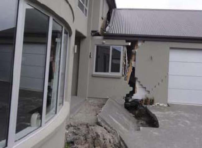
Prevention Tsunami wall 10m high (breached by the tsunami due to land level falling by 3m)
") Plate margin Plates Causes Sendai, Japan Convergent plate margin Pacific and Eurasian Plates Convergent plate margin Sima (Pacific plate) moves towards the sial (Eurasian plate) Sima (Pacific plate) is
Plate margin Plates Causes Sendai, Japan Convergent plate margin Pacific and Eurasian Plates Convergent plate margin Sima (Pacific plate) moves towards the sial (Eurasian plate) Sima (Pacific plate) is
SEISMIC HAZARD ASSESSMENT FOR JAPAN AFTER THE 2011 TOHOKU-OKI MEGA-THRUST EARTHQUAKE (Mw9.0)
") Proceedings of the International Symposium on Engineering Lessons Learned from the 2011 Great East Japan Earthquake, March 1-4, 2012, Tokyo, Japan SEISMIC HAZARD ASSESSMENT FOR JAPAN AFTER THE 2011 TOHOKU-OKI
Proceedings of the International Symposium on Engineering Lessons Learned from the 2011 Great East Japan Earthquake, March 1-4, 2012, Tokyo, Japan SEISMIC HAZARD ASSESSMENT FOR JAPAN AFTER THE 2011 TOHOKU-OKI
Did a submarine landslide contribute to the 2011 Tohoku tsunami?
 Press Release Did a submarine landslide contribute to the 2011 Tohoku tsunami? 1. Key points Large tsunami amplitudes in Northern Tohoku (Sanriku) suggest that a secondary tsunami source lies offshore
The great earthquakes that have shaped Japan 日本に大きな影響を与えた地震
 The great earthquakes that have shaped Japan 日本に大きな影響を与えた地震 Brian Kennett, Research School of Earth Sciences, ANU Takashi Furumura Earthquake Research Institute, University of Tokyo Japan tectonic plates
Interpretive Map Series 24
 Oregon Department of Geology and Mineral Industries Interpretive Map Series 24 Geologic Hazards, and Hazard Maps, and Future Damage Estimates for Six Counties in the Mid/Southern Willamette Valley Including
Introduction to Environmental Geology, 5e
 Lecture Presentation prepared by X. Mara Chen, Salisbury University Introduction to Environmental Geology, 5e Edward A. Keller Chapter 7 Tsunami Case History: Indonesian Tsunami December 26, 2004, within
THE CHARACTERIZING MODEL FOR TSUNAMI SOURCE REGARDING THE INTER-PLATE EARTHQUAKE TSUNAMI
 THE CHARACTERIZING MODEL FOR TSUNAMI SOURCE REGARDING THE INTER-PLATE EARTHQUAKE TSUNAMI Hideharu SUGINO 1, Yoko IWABUCHI 2, Norihiko HASHIMOTO 3, Kazuyuki MATSUSUE 4, Katsumi EBISAWA 5, Hiroyuki KAMEDA
Coastal Vulnerability to Multiple Inundation Sources
 Overview Coastal Vulnerability to Multiple Inundation Sources Dall Osso F., Withycombe G., Summerhayes S., Dominey Howes D. 1. Storm surge and tsunamis 2. The aim of this project 3. Context and background
A probabilistic approach for landslide hazard analysis
 A probabilistic approach for landslide hazard analysis S. Lari, P. Frattimi, G.B. Crosta Engineering Geology 182 (2014) 3-14 報告者 : 符智傑 指導教授 : 李錫堤老師 報告日期 :2016/05/05 Introduction A general framework for
2. Tsunami Source Details
 2. Tsunami Source Details The Northland area faces a range of potential tsunamigenic sources that include several local and distant fault systems and underwater landslides. A NIWA study (Goff et al. 2006)
GIS & Natural Hazards
 GIS & Natural Hazards John McAneney Risk Frontiers 1 mm 10 mm 100 mm 1000 mm 0 1 2 10000 mm kilometres Risk Frontiers An independent and local research capability to: help insurers and reinsurers better
REPORT TO THE PLANNING, TRANSPORTATION AND PROTECTIVE SERVICES COMMITTEE MEETING OF JUNE 26, 2013
 PPS/PS 2013-07 REPORT TO THE PLANNING, TRANSPORTATION AND PROTECTIVE SERVICES COMMITTEE MEETING OF JUNE 26, 2013 SUBJECT UPDATES TO THE CAPITAL REGIONAL DISTRICT MODELLING OF POTENTIAL TSUNAMI INUNDATION
Multi Hazard Evaluation of a High Voltage Transmission Network. John Eidinger 1 and Leon Kempner 2
 Multi Hazard Evaluation of a High Voltage Transmission Network John Eidinger 1 and Leon Kempner 2 1 G&E Engineering Systems Inc., P. O. Box 3592 Olympic Valley, CA 96146-3592; eidinger@earthlink.net. 2
TSUNAMI PROPAGATION AND INUNDATION MODELINGS ALONG SOUTH-EAST COAST OF PAPUA NEW GUINEA
 TSUNAMI PROPAGATION AND INUNDATION MODELINGS ALONG SOUTH-EAST COAST OF PAPUA NEW GUINEA Martin WAREK Supervisor: Yushiro FUJII MEE12620 Bunichiro SHIBAZAKI ABSTRACT This study covers tsunami generation,
Earthquakes and Faulting
 Earthquakes and Faulting Crustal Strength Profile Quakes happen in the strong, brittle layers Great San Francisco Earthquake April 18, 1906, 5:12 AM Quake lasted about 60 seconds San Francisco was devastated
Bayesian tsunami fragility modeling considering input data uncertainty
 Bayesian tsunami fragility modeling considering input data uncertainty Raffaele De Risi Research Associate University of Bristol United Kingdom De Risi, R., Goda, K., Mori, N., & Yasuda, T. (2016). Bayesian
Application of a GIS for Earthquake Hazard Assessment and Risk Mitigation in Vietnam
 Application of a GIS for Earthquake Hazard Assessment and Risk Mitigation in Vietnam Nguyen Hong Phuong Earthquake Information and Tsunami Warning Centre, VAST OUTLINE Introduction Fault Source Model and
Downtown Anchorage Seismic Risk Assessment & Land Use Regulations to Mitigate Seismic Risk
 Prepared for: The Municipality of Anchorage Planning Department and the Geotechnical Advisory Commission Downtown Anchorage Seismic Risk Assessment & Land Use Regulations to Mitigate Seismic Risk Prepared
Tsunami Response and the Enhance PTWC Alerts
 Tsunami Response and the Enhance PTWC Alerts Ken Gledhill GeoNet Project Director Chair, Intergovernmental Coordination Group, Pacific Tsunami Warning and Mitigation System (PTWS) Overview 1. Procedures
at IHO IRCC7 Mexico City, Mexico, June 2015
 Report on Japan s Response to Disasters presented by JHOD at IHO IRCC7 Mexico City, Mexico, 01 03 June 2015 JAPAN COAST GUARD Actions against huge earthquake Actions taken by JHOD against the Great East
Lessons from the 2004 Sumatra earthquake and the Asian tsunami
 Lessons from the 2004 Sumatra earthquake and the Asian tsunami Kenji Satake National Institute of Advanced Industrial Science and Technology Outline 1. The largest earthquake in the last 40 years 2. Tsunami
SAGEEP 2012 Tucson, Arizona USA GEOPHYSICAL AND GEOTECHNICAL FEATURES OF THE LEVEE SYSTEMS DAMAGED BY THE EAST JAPAN EARTHQUAKE
 GEOPHYSICAL AND GEOTECHNICAL FEATURES OF THE LEVEE SYSTEMS DAMAGED BY THE EAST JAPAN EARTHQUAKE Tomio INAZAKI, Public Works Research Institute, Tsukuba, JAPAN Abstract Levee systems in Kanto Region, central
Damage of Sewage Plant by Tsunami
 Damage of Sewage Plant by Tsunami K. Fujima & Y. Shigihara National Defense Acadfemy, Japan SUMMARY: This work describes a damage assessment of a sewage plant in Shizuoka city by next Tokai earthquake
We have previously looked at artificial seismograms such as this one here.
 We have previously looked at artificial seismograms such as this one here. S P A realistic Seismic Record Each vertical line = 1 minute Each horizontal line = 15 minutes Seismic station PMM is in Parkfield,
I. Locations of Earthquakes. Announcements. Earthquakes Ch. 5. video Northridge, California earthquake, lecture on Chapter 5 Earthquakes!
 51-100-21 Environmental Geology Summer 2006 Tuesday & Thursday 6-9:20 p.m. Dr. Beyer Earthquakes Ch. 5 I. Locations of Earthquakes II. Earthquake Processes III. Effects of Earthquakes IV. Earthquake Risk
Source region of the earthquake
 Disasters of port facilities due to 2011 Great East Japan Earthquake Yoshiaki Kikuchi Port & Airport Research Institute Contents Outline of the earthquake Measured Tsunami height Breakwater disasters by
MODELLING FROST RISK IN APPLE TREE, IRAN. Mohammad Rahimi
 WMO Regional Seminar on strategic Capacity Development of National Meteorological and Hydrological Services in RA II (Opportunity and Challenges in 21th century) Tashkent, Uzbekistan, 3-4 December 2008
Effect of an outer-rise earthquake on seismic cycle of large interplate earthquakes estimated from an instability model based on friction mechanics
 Effect of an outer-rise earthquake on seismic cycle of large interplate earthquakes estimated from an instability model based on friction mechanics Naoyuki Kato (1) and Tomowo Hirasawa (2) (1) Geological
Applying Hazard Maps to Urban Planning
 Applying Hazard Maps to Urban Planning September 10th, 2014 SAKAI Yuko Disaster Management Expert JICA Study Team for the Metro Cebu Roadmap Study on the Sustainable Urban Development 1 Contents 1. Outline
Tsunami Inundation Modeling in the Aegean Sea
 Tsunami Inundation Modeling in the Aegean Sea B. Aydın Akdeniz University, Antalya, Turkey O. Hoto & U. Kânoğlu Middle East Technical University, Ankara, Turkey SUMMARY: The tsunami forecasting system
The RMS US inland flood model
 The RMS US inland flood model Sonja Jankowfsky 1,2,a, Arno Hilberts 2, Christian Mortgat 1, Shuangcai Li 1, Na Xu 1, Yi Mei 1, Stephan Tillmanns 3, Ye Tian 1, Yang Yang 1 1 Risk Management Solutions, Inc.,
Study on Quantification Methodology of accident sequences for Tsunami Induced by Seismic Events.
 Study on Quantification Methodology of accident sequences for Tsunami Induced by Seismic Events 1 Keisuke Usui, 2 Hitoshi Muta, 3 Ken Muramatsu 1 Graduate Student, Corporative Major in Nuclear Energy:
Some Problems Related to Empirical Predictions of Strong Motion
 Bull. Earthq. Res. Inst. Univ. Tokyo Vol. 2+,**0 pp.,/-,/2 Some Problems Related to Empirical Predictions of Strong Motion Saburoh Midorikawa + * + Center for Urban Earthquake Engineering, Tokyo Institute
A Study on the Risk Assessment of Emergency Supplies. Transportation Routes Considering Scenario Earthquakes
 ORIGINAL ARTICLE A Study on the Risk Assessment of Emergency Supplies Transportation s Considering Scenario Earthquakes Kazuaki Torisawa 1, Harumi Yashiro 2, Sei ichiro Fukushima 3*, Satoshi Kina 4 1 Kajima
The 2011 Tohoku Earthquake and Tsunami Sequence. Mitchell May, EPSC 330
 The 2011 Tohoku Earthquake and Tsunami Sequence Mitchell May, 260556044 EPSC 330 The 2011 earthquake sequence east of Tohoku is classified as a megathrust earthquake off the east coast of Japan. The earthquake
Understanding Seismic Hazard Needs for Infrastructure Risk Analysis: Lessons from SYNER-G
 Systemic Seismic Vulnerability and Risk Analysis for Buildings, Lifeline Networks and Infrastructures Safety Gain Understanding Seismic Hazard Needs for Infrastructure Risk Analysis: Lessons from SYNER-G
Riskscape module Documentation: Inundation Modelling in Bay of Plenty. X. Wang C. Mueller
 Riskscape module Documentation: Inundation Modelling in Bay of Plenty X. Wang C. Mueller CONTENTS 1.0 GENERAL INFORMATION... 2 1.1 SITE OF STUDY... 5 1.2 SOURCE SCENARIOS... 5 1.3 NUMERICAL MODEL... 5
New Zealand s Next Top Model: integrating tsunami modelling into land use planning
 New Zealand s Next Top Model: integrating tsunami modelling into land use planning Wendy Saunders (MZNZPI), Gegar Prasetya, Graham Leonard GNS Science, Lower Hutt, w.saunders@gns.cri.nz In April 2011 a
Overview of Consequences of the Tsunami in Thailand and Roles and Activities of the Department of Mineral Resources after the 26 December 2004 Tsunami
 Overview of Consequences of the Tsunami in Thailand and Roles and Activities of the after the 26 December 2004 Tsunami By Mr.Worawoot Tantiwanit, Thailand 1 Earthquake in NW of North Sumatra Island 580
TSUNAMI CHARACTERISTICS OF OUTER-RISE EARTHQUAKES ALONG THE PACIFIC COAST OF NICARAGUA - A CASE STUDY FOR THE 2016 NICARAGUA EVENT-
 TSUNAMI CHARACTERISTICS OF OUTER-RISE EARTHQUAKES ALONG THE PACIFIC COAST OF NICARAGUA - A CASE STUDY FOR THE 2016 NICARAGUA EVENT- Amilcar Cabrera Supervisor: Yuichiro TANIOKA MEE16718 ABSTRACT Nicaragua
Earthquake Risk in Canada and the National Building Code
 Earthquake Risk in Canada and the National Building Code Tuna Onur, Ph.D. Onur Seemann Consulting, Inc. NICC, Vancouver, BC, 28-30 September 2016 Southwestern Canada: Cascadia Subduction Zone + Crustal
Hitoshi Hirose (1), and Kazuro Hirahara (2) Abstract. Introduction
, and Kazuro Hirahara (2) Abstract. Introduction") Three dimensional simulation for the earthquake cycle at a subduction zone based on a rate- and state-dependent friction law: Insight into a finiteness and a variety of dip-slip earthquakes Hitoshi Hirose
Three dimensional simulation for the earthquake cycle at a subduction zone based on a rate- and state-dependent friction law: Insight into a finiteness and a variety of dip-slip earthquakes Hitoshi Hirose
Finding an Earthquake Epicenter Pearson Education, Inc.
 Finding an Earthquake Epicenter Measuring the Size of Earthquakes Two measurements that describe the size of an earthquake are: 1. Intensity a measure of the degree of earthquake shaking at a given locale
PoS(ISGC 2011 & OGF 31)078
078") Modeling scenarios of earthquake-generated tsunamis for Vietnam coasts Davide Bisignano Università degli Studi di Trieste, Department of Geosciences Via E. Weiss 4, Trieste, Italy E-mail: davide.bisignano@gmail.com
Modeling scenarios of earthquake-generated tsunamis for Vietnam coasts Davide Bisignano Università degli Studi di Trieste, Department of Geosciences Via E. Weiss 4, Trieste, Italy E-mail: davide.bisignano@gmail.com
Changes in the Level of Convenience of the Iwate Prefecture Temporary Housing Complexes Constructed after the 2011 Tohoku Earthquake
 Changes in the Level of Convenience of the Iwate Prefecture Temporary Housing Complexes Constructed after the 2011 Tohoku Earthquake Shin-ichi Konno, Risa Shibutani, and Noriaki Endo Abstract We evaluated
MISSOURI LiDAR Stakeholders Meeting
 MISSOURI LiDAR Stakeholders Meeting East-West Gateway June 18, 2010 Tim Haithcoat Missouri GIO Enhanced Elevation Data What s different about it? Business requirements are changing.fast New data collection
Impacts of Climate Change and Water-Related Disaster Reduction Management in the Asia-Pacific Region
 Impacts of Climate Change and Water-Related Disaster Reduction Management in the Asia-Pacific Region Katumi MUSIAKE Professor, Fukushima University Secretary General, Asia Pacific Association of Hydrology
Earthquakes and Earthquake Hazards Earth - Chapter 11 Stan Hatfield Southwestern Illinois College
 Earthquakes and Earthquake Hazards Earth - Chapter 11 Stan Hatfield Southwestern Illinois College What Is an Earthquake? An earthquake is the vibration of Earth, produced by the rapid release of energy.
Groundwater changes related to the 2011 Off the Pacific Coast of Tohoku Earthquake (M9.0)
") Groundwater changes related to the 2011 Off the Pacific Coast of Tohoku Earthquake (M9.0) Yuichi Kitagawa Senior Research Scientist, AIST, GSJ, Active Fault and Earthquake Research Cente Naoji Koizumi
Groundwater changes related to the 2011 Off the Pacific Coast of Tohoku Earthquake (M9.0) Yuichi Kitagawa Senior Research Scientist, AIST, GSJ, Active Fault and Earthquake Research Cente Naoji Koizumi
Natural Disaster and Coastal Geomorphology
 Natural Disaster and Coastal Geomorphology Shigeko Haruyama Toshihiko Sugai Editors Natural Disaster and Coastal Geomorphology 123 Editors Shigeko Haruyama Mie University Tsu Japan Toshihiko Sugai The