and applications Litto 3 D - GEBCO 09/29/09 Vincent DONATO
|
|
|
- Jasmin Dennis
- 6 years ago
- Views:
Transcription


1 Litto 3 D and applications Vincent DONATO
2 Contents Litto3D project Applications : modeling sea-land interaction Simulating the tide Cadastral management Sea-rising risk management

3 Continuous, high resolution altimetric model on the littoral


4 Litto 3 D The coastal area is economically important


5 Litto 3 D But the littoral is fragile
6 Litto 3 D Recent catastrophes on the littoral pointed out the need for a specific mapping of this area In France, SHOM and IGN were appointed to elaborate a seamless altimetric model on the littoral : Litto 3 D
7 Litto 3 D Two steps : Merging IGN and SHOM historical database for producing low-res DTM on the littoral : HistoLitt Producing high-res seamless DTM with modern means


8 HistoLitt SHOM IGN

9 HistoLitt Merged data
10 HistoLitt Merged data

11 HistoLitt Quickly and widely available Fit many applications Resolution ~ 50m Holes in the sand
12 Litto 3 D New surveys LIDAR, MBES, DGPS Sub-metric resolution Better coverage of low-water areas

13 Litto 3 D

14 Litto 3 D Landward : better resolution Pixel : 30 cm Precision Z : 15 cm

15 Litto 3 D 100% coverage Mesh : 3 m Precision : 30 cm Seaward : better coverage


16 Litto 3 D Before / After
17 Litto 3 D Prototypes : Golfe du Morbihan Validated and released Toulon area Released late 2009 Ongoing La Réunion, Mayotte, Scattered Islands, Languedoc-Roussillon Projects North Finistère Martinique
18 Litto 3 D - Applications Potentiality of these new data (example and prospects) Harbors infrastructures management Sedimentology Coupling with tide model Base for Integrated coastal zone management (ICZM)

19 Litto 3 D - Applications Harbors infrastructure : Toulon s jetty
20 Litto 3 D - Applications Harbors infrastructure : Toulon s jetty


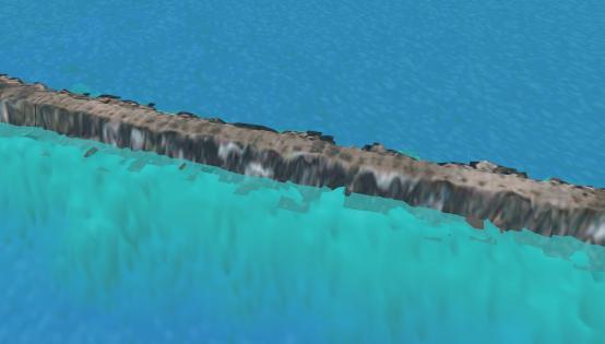

21 Litto 3 D - Applications Harbors infrastructure : Toulon s jetty

22 Litto 3 D - Applications Sedimentology
23 Litto 3 D - Applications Realistic modeling of littoral environment Coupling Litto3D with hydrodynamic tide model Evaluating two use-cases Littoral d Anglet - Bayonne Golfe du Morbihan Applications
24 Step 1 Modeling the tide Simulation of a tide cycle day and time are configurable Based on hydrodynamical models from HDC (SHOM)

25 Step 1 Modeling the tide

26 Step 1 Modeling the tide

27 Step 1 Modeling the tide
28 Step 1 Modeling the tide Demo
29 Step 2 Modeling the coast Golfe du Morbihan - Litto3D Bayonne HISTOLITT


30 Step 2 Modeling the coast Golfe du Morbihan Bayonne

31 Coupling the two models
32 Coupling the two models Demo
 Dedicated Zero H model Exhaustive")
33 Cases Comparison Anglet Bayonne Sea : Historical Data Land : BDAlti 50m Generic HDC model (5km mesh) No Zero Hydro model Intertidal zone not covered Golfe du Morbihan Bathymetric Lidar Litto3D Topographic Lidar Dedicated HDC model (200m) Dedicated Zero H model Exhaustive coverage

34 Results - Bayonne

35 Results - Bayonne

36 Results - Bayonne

37 Results Golfe du Morbihan
38 Results Golfe du Morbihan Results are not bad but are they good? Need to qualify the result Correlation observation / Simulation Use of time-stamped observations Aerial imagery Ground observations


39


40


41 March h09


42 March h25
43 Applications (Example and prospects) Generalities The simulation itself is an application! «What will the sea look like, D-Day H-hour?» Potential interest of public (fishers, leasure, pedagogic, etc.)
44 Applications Littoral management Under study : Impact of sea rise Cadastral delineation
45 Ocean rising High tide Coefficient 108 Elevation : 0 cm
46 Ocean rising High tide Coefficient 108 Elevation : 40 cm
47 Ocean rising High tide Coefficient 108 Elevation : 100 cm

48 Ocean rising High tide Coefficient 108 Elevation : 190 cm

49 Ocean rising Low tide Coefficient 108 Elevation : 0 cm

50 Ocean rising Low tide Coefficient 108 Elevation : 190 cm
51 Littoral management Delineation of Maritime Public Domain (French DPM) DPM is the level of highest astronomical tide (without atmospheric perturbation) Today : Delineated by terrain campaigns Intersection between Litto3D model and the highest level of a simulated astronomical tide.

52 Domaine Public Maritime

53 Domaine Public Maritime
54 CONCLUSIONS Litto3D gives new potential to existing data New products and services Anticipation of sea-rise risk Cadastral management spatial planning Simulation for the public
Antoine Masse, Sidonie Christophe
 Antoine Masse, Sidonie Christophe IGN, COGIT Laboratory France Motivation: coastal area geovisualization Coastal area Between highest astronomical tide (shoreline) and lowest astronomical tide (drying
Marine environment monitoring : The basic requirements to support Marine Renewable Energies
 Marine environment monitoring : The basic requirements to support Marine Renewable Energies SHOM in brief SHOM is the French Government agency in charge of Hydrography and Oceanography SHOM s vocation
Coastal Flood Risk Study Project for East Coast Central Florida Study Area
 Coastal Flood Risk Study Project for East Coast Central Florida Study Area St Lucie County, Florida Flood Risk Review Meeting March 28, 2017 Introductions Risk MAP Project Team FEMA Region IV BakerAECOM,
Storm Surge Analysis Update Meeting Cross City, Florida June 17, 2014
 Big Bend Coastal Storm Surge Study Storm Surge Analysis Update Meeting Cross City, Florida June 17, 2014 Introductions Risk MAP Project Team FEMA Region IV Florida Division of Emergency Management (FDEM)
Location: Jacksonville, FL December 11, 2012
 Technical Update Meeting Northeast Florida Surge Study Location: Jacksonville, FL December 11, 2012 Agenda 2:00 2:15 Welcome/Introductions Tucker Mahoney, FEMA Region IV Michael DelCharco, BakerAECOM 2:15
Clive Schofield * and David Freestone **
 Holding Back the Waves: Options to Secure Maritime Jurisdictional Claims in the Face of Sea Level Rise Clive Schofield * and David Freestone ** *Australian National Centre for Ocean Resources and Security
Supplement of Scenario-based numerical modelling and the palaeo-historic record of tsunamis in Wallis and Futuna, Southwest Pacific
 Supplement of Nat. Hazards Earth Syst. Sci., 15, 1763 1784, 2015 http://www.nat-hazards-earth-syst-sci.net/15/1763/2015/ doi:10.5194/nhess-15-1763-2015-supplement Author(s) 2015. CC Attribution 3.0 License.
Celine DUFFA / Hervé THEBAULT. A radioecological risk assessment tool for post-accidental situations: application in the Toulon marine area
 Celine DUFFA / Hervé THEBAULT A radioecological risk assessment tool for post-accidental situations: application in the Toulon marine area Objectives and method IRSN carries out research on the consequences
Geographic information for Strasbourg : from historical land register to 3D GIS city modelling 09/07/2017
 Geographic information for Strasbourg : from historical land register to 3D GIS city modelling 09/07/2017 Table of contents 1. Introduction of Strasbourg 2. A century of land surveying and cadastre 3.
R E P U B L I C O F C Y P R U S NATIONAL REPORT OF CYPRUS TO THE MEDITERRANEAN AND BLACK SEAS HYDROGRAPHIC COMMISSION (MBSHC)
") R E P U B L I C O F C Y P R U S NATIONAL REPORT OF CYPRUS TO THE MEDITERRANEAN AND BLACK SEAS HYDROGRAPHIC COMMISSION (MBSHC) ISTANBUL MEETING 25-27 SEPTEMBER 2013 NATIONAL REPORT OF CYPRUS TO THE MEDITERRANEAN
R E P U B L I C O F C Y P R U S NATIONAL REPORT OF CYPRUS TO THE MEDITERRANEAN AND BLACK SEAS HYDROGRAPHIC COMMISSION (MBSHC) ISTANBUL MEETING 25-27 SEPTEMBER 2013 NATIONAL REPORT OF CYPRUS TO THE MEDITERRANEAN
DELINEATION OF COASTLINE AND MARINE SDI IN CROATIA
 CO-090 DELINEATION OF COASTLINE AND MARINE SDI IN CROATIA LEDER N.(1), DUPLANČIĆ LEDER T.(2) (1) Hydrographic Institute of the Republic of Croatia, SPLIT, CROATIA ; (2) Faculty of Civil Engineering and
Spanish national plan for land observation: new collaborative production system in Europe
 ADVANCE UNEDITED VERSION UNITED NATIONS E/CONF.103/5/Add.1 Economic and Social Affairs 9 July 2013 Tenth United Nations Regional Cartographic Conference for the Americas New York, 19-23, August 2013 Item
Airborne LiDAR Bathymetry in French Polynesia. Luke Chamberlain Fugro LADS Corporation
 Airborne LiDAR Bathymetry in French Polynesia Mark Sinclair Fugro LADS Corporation Luke Chamberlain Fugro LADS Corporation Yves Pastol - SHOM A remote area: Distance from Christchurch to Polynesia ~2,470
EU HOs in Mediterranean and Black Sea (MBS) CROATIA FRANCE GREECE ITALY MALTA X SLOVENIA X SPAIN ROMANIA X
 CROATIA FRANCE GREECE ITALY MALTA X SLOVENIA X SPAIN ROMANIA X") EU HOs in Mediterranean and Black Sea (MBS) CROATIA FRANCE GREECE ITALY MALTA X SLOVENIA X SPAIN ROMANIA X Croatia Current status of hydrographic survey in acc. IHO C-55 pub. criteria Croatia Croatia by
EU HOs in Mediterranean and Black Sea (MBS) CROATIA FRANCE GREECE ITALY MALTA X SLOVENIA X SPAIN ROMANIA X Croatia Current status of hydrographic survey in acc. IHO C-55 pub. criteria Croatia Croatia by
Fugro Geospatial: Turning Spatial Data into Knowledge
 Fugro Geospatial: Turning Spatial Data into Knowledge 2016 Fugro Geospatial, GIS and Consultants Locations Variety of Collection Platforms Traditional Mapping Traditional Mapping Imagery Photogrammetric
Storm Surge Analysis Update Meeting Charlotte and DeSoto Counties, Florida March 7, 2018
 Southwest Florida Coastal Storm Surge Study Storm Surge Analysis Update Meeting Charlotte and DeSoto Counties, Florida March 7, 2018 Agenda Introductions Goals for Today SWFL Coastal Surge Study Study
Flood protection structure detection with Lidar: examples on French Mediterranean rivers and coastal areas
 Flood protection structure detection with Lidar: examples on French Mediterranean rivers and coastal areas Céline Trmal 1,a, Frédéric Pons 1 and Patrick Ledoux 1 1 Cerema, Direction Territoriale Méditerranée,
GEOMATICS. Shaping our world. A company of
 GEOMATICS Shaping our world A company of OUR EXPERTISE Geomatics Geomatics plays a mayor role in hydropower, land and water resources, urban development, transport & mobility, renewable energy, and infrastructure
Positioning the Pacific: NOAA s Geospatial Activities. Juliana Blackwell, Director NOAA s National Geodetic Survey March 6, 2012
 Positioning the Pacific: NOAA s Geospatial Activities Juliana Blackwell, Director NOAA s National Geodetic Survey March 6, 2012 A Common Problem of the Early 19 th Century 1807 President Thomas Jefferson
HOW HAS INSPIRE PROMOTED THE EMERGENCE OF A SPATIAL DATA INFRASTRUCTURE FOR THE MARINE COMMUNITY IN THE SOUTH WEST OF THE INDIAN OCEAN?
 HOW HAS INSPIRE PROMOTED THE EMERGENCE OF A SPATIAL DATA INFRASTRUCTURE FOR THE MARINE COMMUNITY IN THE SOUTH WEST OF THE INDIAN OCEAN? Erwann Quimbert, Michel Ropert, Catherine Satra Le Bris, Julien Meillon,
Assessing Storm Tide Hazard for the North-West Coast of Australia using an Integrated High-Resolution Model System
 Assessing Storm Tide Hazard for the North-West Coast of Australia using an Integrated High-Resolution Model System J. Churchill, D. Taylor, J. Burston, J. Dent September 14, 2017, Presenter Jim Churchill
Coastal Flood Risk Study Project for Northeast Florida Study Area
 Coastal Flood Risk Study Project for Northeast Florida Study Area Duval County, Florida Flood Risk Review Meeting September 22, 2015 Introductions Risk MAP Project Team FEMA Region IV BakerAECOM, FEMA
Earth Observation in coastal zone MetOcean design criteria
 ESA Oil & Gas Workshop 2010 Earth Observation in coastal zone MetOcean design criteria Cees de Valk BMT ARGOSS Wind, wave and current design criteria geophysical process uncertainty modelling assumptions
Sea level rise and coastal morphological changes on tropical islands New Caledonia and French Polynesia (South Pacific)
") Manuel Garcin, Marissa Yates, Goneri Le Cozannet, Patrice Walker, Vincent Donato Sea level rise and coastal morphological changes on tropical islands New Caledonia and French Polynesia (South Pacific)
Manuel Garcin, Marissa Yates, Goneri Le Cozannet, Patrice Walker, Vincent Donato Sea level rise and coastal morphological changes on tropical islands New Caledonia and French Polynesia (South Pacific)
Storm surge modeling at RSMC La Réunion. Cliquez pour modifier le style des sous-titres du masque
 Storm surge modeling at RSMC La Réunion Cliquez pour modifier le style du titre Cliquez pour modifier le style des sous-titres du masque 6th session training course of tropical cyclones (28 oct. 5 nov.
Ramani Geosystems. Putting Africa On The Map. Authorized Resellers
 Ramani Geosystems Putting Africa On The Map Authorized Resellers Ramani Profile Started in 1999 Aerial, Land Surveying & Mapping Solutions + 10 Countries in the region + 80 Staff working in projects Asset
Shoreline Mapping & Erosion Patterns. Julia Knisel Julia Knisel Coastal Shoreline & Floodplain Manager
 Shoreline Mapping & Erosion Patterns Along the Massachusetts Coast Julia Knisel Julia Knisel Coastal Shoreline & Floodplain Manager CZM Shoreline Change Project Timeline 1989: produced coast wide maps
Miami-Dade County Technical Update Meeting South Florida Coastal Study. May 11, 2016
 Miami-Dade County Technical Update Meeting South Florida Coastal Study May 11, 2016 Welcome and Introductions FEMA Region IV Christina Lindemer Technical Lead Production and Technical Services (PTS) Contractor
The 3D Elevation Program: Overview. Jason Stoker USGS National Geospatial Program ESRI 2015 UC
 + The 3D Elevation Program: Overview Jason Stoker USGS National Geospatial Program ESRI 2015 UC + 2 A little history USGS has a long, proud tradition of mapmaking (2009) + 3 The changing times Mapping
Future Ocean Floor Mapping: Ocean Stewardship & Initial Industry Contributions. U.S Hydro Galveston, TX March 23, 2017 David Millar - Fugro
 Future Ocean Floor Mapping: Ocean Stewardship & Initial Industry Contributions U.S Hydro 2017 - Galveston, TX March 23, 2017 David Millar - Fugro Presentation Outline The Need for Ocean Mapping GEBCO GEBCO
Protecting the Storm Damage Prevention and Flood Control Interests of Coastal Resource Areas
 Protecting the Storm Damage Prevention and Flood Control Interests of Coastal Resource Areas Presented by: Massachusetts Department of Environmental Protection & Massachusetts Office of Coastal Zone Management
UNITED NATIONS E/CONF.96/CRP. 5
 UNITED NATIONS E/CONF.96/CRP. 5 ECONOMIC AND SOCIAL COUNCIL Eighth United Nations Regional Cartographic Conference for the Americas New York, 27 June -1 July 2005 Item 5 of the provisional agenda* COUNTRY
AIRBORNE LIDAR BATHYMETRY By the Japan Hydrographic and Oceanographic Department
 AIRBORNE LIDAR BATHYMETRY By the Japan Hydrographic and Oceanographic Department H. OGAWA, K. OYAKAWA, K. KAWAI, H. OZAWA, H. YAJIMA, H. SHIRANE, H. YAMANO, N. HIRATA, N. IWAMOTO, T. ONO, S. TOMIZAWA,
French Seagrass indicator - Atlantic and Channel CW & TW NEA GIG
 French Seagrass indicator - Atlantic and Channel CW & TW NEA GIG Scientific team Isabelle Auby, Ifremer Arcachon Hélène Oger-Jeanneret, Ifremer Nantes Pierre-Guy Sauriau, CNRS, LIENSs Christian Hily, CNRS,
Coastline monitoring. Virginie Lafon Cyril Mallet. S. Capo, A. Dehouck, E. Maneux, A. Michot, C. Proisy, R. Walker
 Coastline monitoring Virginie Lafon Cyril Mallet Doris_Net May 29, 2012 Pessac, France S. Capo, A. Dehouck, E. Maneux, A. Michot, C. Proisy, R. Walker 29/05/2012 Spatial applications for coastal services
BLAST Harmonising spatial information across the North Sea region
 b r i n g i n g l a n d a n d s e a t o g e t h e r BLAST Content: Harmonising spatial information across the North Sea region 3 BLAST Harmonising spatial information across the North Sea region 4 6 8
Coastal Inlets Research Program US Army Corps of Engineers Engineering Research and Development Center
 Coastal Inlets Research Program US Army Corps of Engineers Engineering Research and Development Center Site of Moriches Inlet Nov. 1951 Julie Dean Rosati and Nicholas C. Kraus, CIRP Program Manager Shinnecock
South Florida Coastal Storm Surge and Mapping Study
 South Florida Coastal Storm Surge and Mapping Study Presented by Christopher Bender, Ph.D., P.E., D.CE June 2, 2015 Presentation Overview FEMA risk studies outline Overview South Florida surge study Work
QUESTIONNAIRE THE CURRENT STATUS OF MAPPING IN THE WORLD
 QUESTIONNAIRE ON THE CURRENT STATUS OF MAPPING IN THE WORLD The questionnaire is intended to take stock of the current status of mapping in the world. The information collected will eventually be used
WP4: COASTAL PROCESSES
 WP4: COASTAL PROCESSES Coordinator: G. EBERHARDS Faculty of Geography and Earth Sciences, University of Latvia Daugavpils, 2008 Goal: The objective of this study is analysis of coastal changes and forecast
EMODnet High Resolution Seabed Mapping - further developing a high resolution digital bathymetry for European seas
 EMODnet High Resolution Seabed Mapping - further developing a high resolution digital bathymetry for European seas IMDIS 2018 Conference, 7 November 2018, Barcelona - Spain Thierry Schmitt Dick M.A. Schaap
DATA APPLIANCE FOR ARCGIS
 DATA APPLIANCE FOR ARCGIS Data Appliance for ArcGIS Provides Access to Multi-Scale Basemaps Down to Medium Scale Levels Worldwide And Large Scale for Most of the World The Data Appliance includes Several
Pilot service: Southern Emilia Romagna (Italy)
") Pilot service: Southern Emilia Romagna (Italy) Surface deformation service provider (PSInSAR TM ) Geodetic and optical remote sensing data integration Final user The study area The Southern Emilia-Romagna
Pilot service: Southern Emilia Romagna (Italy) Surface deformation service provider (PSInSAR TM ) Geodetic and optical remote sensing data integration Final user The study area The Southern Emilia-Romagna
Current and Future Technology Applications for Coastal Zone Management. Bruce K. Carlisle, Acting Director Office of Coastal Zone Management
 Current and Future Technology Applications for Coastal Zone Management Bruce K. Carlisle, Acting Director Office of Coastal Zone Management The Massachusetts Coastal Zone Management Program Approved in
Preliminary Data Release for the Humboldt Bay Sea Level Rise Vulnerability Assessment: Humboldt Bay Sea Level Rise Inundation Mapping
 Preliminary Data Release for the Humboldt Bay Sea Level Rise Vulnerability Assessment: Humboldt Bay Sea Level Rise Inundation Mapping Prepared by: Jeff Anderson, Northern Hydrology & Engineering (jeff@northernhydrology.com)
Mapping, monitoring, and modeling: USGS Coastal and Marine Geology activities along the Northeast coast
 Mapping, monitoring, and modeling: USGS Coastal and Marine Geology activities along the Northeast coast Coastal and Marine Geology Program Woods Hole Coastal and Marine Science Center St. Petersburg Coastal
Coastal Processes and Shoreline Erosion on the Oregon Coast, Cascade Head to Cape Kiwanda
 State of Oregon Department of Geology and Mineral Industries Vicki S. McConnell, State Geologist Open File Report OFR O-04-11 Coastal Processes and Shoreline Erosion on the Oregon Coast, Cascade Head to
COASTAL QUATERNARY GEOLOGY MAPPING FOR NSW: EXAMPLES AND APPLICATIONS
 COASTAL QUATERNARY GEOLOGY MAPPING FOR NSW: EXAMPLES AND APPLICATIONS A Troedson Geological Survey of New South Wales Abstract Detailed geological mapping of the coastal plains of regional NSW was undertaken
DIVISION OF COASTAL MANAGEMENT TO STUDY CURRENT LONG-TERM EROSION RATES ADJACENT TO TERMINAL GROINS
 DIVISION OF COASTAL MANAGEMENT TO STUDY CURRENT LONG-TERM EROSION RATES ADJACENT TO TERMINAL GROINS North Carolina Department of Environmental Quality Division of Coastal Management February 22, 2018 N.
Coastal data for Integrated Maritime Policies
 Coastal data for Integrated Maritime Policies LOCHET Corine Shom Name of presentation Protection against erosion and marine flood Name presenter Link between different data scales and Name of presentation
ORFEO Accompaniment Program: Toward the Preparation of the Thematic Use of PLEIADES Imagery G. BLANCHET CNES (DCT/SI/AP)
") ORFEO Accompaniment Program: Toward the Preparation of the Thematic Use of PLEIADES Imagery G. BLANCHET CNES (DCT/SI/AP) 1 Three phases : Phase 1 : ORFEO Program Overview (1/3) Identification of users
ORFEO Accompaniment Program: Toward the Preparation of the Thematic Use of PLEIADES Imagery G. BLANCHET CNES (DCT/SI/AP) 1 Three phases : Phase 1 : ORFEO Program Overview (1/3) Identification of users
EMERGENCY PLANNING IN NORTHERN ALGERIA BASED ON REMOTE SENSING DATA IN RESPECT TO TSUNAMI HAZARD PREPAREDNESS
 EMERGENCY PLANNING IN NORTHERN ALGERIA BASED ON REMOTE SENSING DATA IN RESPECT TO TSUNAMI HAZARD PREPAREDNESS Barbara Theilen-Willige Technical University of Berlin, Institute of Applied Geosciences Department
EMODnet High Resolution Seabed Mapping - further developing and providing a high resolution digital bathymetry for European seas
 EMODnet High Resolution Seabed Mapping - further developing and providing a high resolution digital bathymetry for European seas EGU Fall 2017 meeting New Orleans USA, December 2017 Schaap Dick MARIS,
NEEA Refresh aka 3D Nation Requirements and Benefits Study. Allyson Jason, Carol Ostergren, Xan Fredericks and Lou Driber November 9, 2017
 + NEEA Refresh aka 3D Nation Requirements and Benefits Study Allyson Jason, Carol Ostergren, Xan Fredericks and Lou Driber November 9, 2017 + 2 Study Context Background The National Enhanced Elevation
The Integration of Land and Marine Spatial Data Set As Part of Indonesian Spatial Data Infrastructure Development
 UNITED NATIONS E/CONF.97/6/IP. 46 ECONOMIC AND SOCIAL COUNCIL Seventeenth United Nations Regional Cartographic Conference for Asia and the Pacific Bangkok, 18-22 September 2006 Item 7 of the provisional
Country Report On Sdi Activities In Singapore ( )
") UNITED NATIONS E/CONF.102/IP.4 ECONOMIC AND SOCIAL COUNCIL Nineteenth United Nations Regional Cartographic Conference for Asia and the Pacific Bangkok, 29 October 1 November 2012 Item 6(b) of the provisional
UNITED NATIONS E/CONF.102/IP.4 ECONOMIC AND SOCIAL COUNCIL Nineteenth United Nations Regional Cartographic Conference for Asia and the Pacific Bangkok, 29 October 1 November 2012 Item 6(b) of the provisional
To achieve these Global Sustainable Development Goals, geospatial data are crucial.
 To achieve these Global Sustainable Development Goals, geospatial data are crucial. 2 http://www.globalgoals.org/ HIGH INCOME NATION SUSTAINABLE GROWTH SOCIALLY INCLUSIVE 3 http://etp.pemandu.gov.my/ 12
BANGLADESH SURVEY OF BANGLADESH PREMISES
 BANGLADESH SURVEY OF BANGLADESH PREMISES Survey of Bangladesh (SOB) is the National Mapping organization of Bangladesh SOB is carrying out all Geodetic activities of Bangladesh SOB is responsible for taking
multibeam bathymetric data is often based on the local depth datum, which is the local lowest normal low sea level, see the Figure 1. Multibeam Bathym
 3D DYNAMIC TERRAIN VISUALIZATION OF ISLAND AREAS AI Bo a, *, TANG Xinming b, SHI Shaoyu c, WANG Hongyan d, YANG Fanlin e a Geomatics College, Shandong University of Science and Technology, Qingdao, China
Determining the Maritime Baseline for Marine Cadastre
 Determining the Maritime Baseline for Marine Cadastre Robin SEET, Malaysia, David FORREST, United Kingdom, Jim HANSOM, United Kingdom Key words: Marine Cadastre, low-water line, maritime baseline, Digital
of the Resource Management Act 1991 ("Act") (ENV-2013-AKL )
 (ENV-2013-AKL )") BEFORE THE ENVIRONMENT COURT IN THE MATTER of the Resource Management Act 1991 ("Act") AND IN THE MATTER of a Notice of Motion under section 87G of the Act requesting the granting of resource consents
BEFORE THE ENVIRONMENT COURT IN THE MATTER of the Resource Management Act 1991 ("Act") AND IN THE MATTER of a Notice of Motion under section 87G of the Act requesting the granting of resource consents
A methodology for impact, vulnerability and adaptation assessment in the coastal zone
 UNFCCC expert meeting on methods and tools and on data and observations under the Nairobi work programme on impacts, vulnerability and adaptation to climate change Mexico City, Mexico, 4-7 March 2008 A
ESRI GIS For Mining Seminar, 10 th August, 2016, Nairobi, Kenya. Spatial DATA Solutions for Mining
 ESRI GIS For Mining Seminar, 10 th August, 2016, Nairobi, Kenya Spatial DATA Solutions for Mining Spatial Data Solutions for Mining Spatial - Data that identifies the geographic location of features &
CLICK HERE TO KNOW MORE
 CLICK HERE TO KNOW MORE GENERALIZATION OF TOPOGRAPHIC DATABASE FOR SERVING GEOSPATIAL DATA FOR MILITARY AND SOCIO-ECONOMIC TASKS IN VIETNAM Speaker: Lieutenant Colonel, Nguyen Dinh Minh GENERAL STAFF -
Using the Mercator ocean forecasting system to compute coastal maritime pollution risk indicators on the Atlantic European coasts
 Environmental Problems in Coastal Regions VI 437 Using the Mercator ocean forecasting system to compute coastal maritime pollution risk indicators on the Atlantic European coasts S. Besnard 1, E. Dombrowsky
Contemporary Data Collection and Spatial Information Management Techniques to support Good Land Policies
 Contemporary Data Collection and Spatial Information Management Techniques to support Good Land Policies Ch. Ioannidis Associate Professor FIG Commission 3 Workshop Paris, 25-28 October 2011 Introduction
FIG Working Week May, Bulgaria From the wisdom of the ages to the challanges of modern world
 FIG Working Week 17-21 May, Bulgaria From the wisdom of the ages to the challanges of modern world COASTAL RISK ANALYSIS OF THE BLACK SEA UNDER THE SEA LEVEL RISE N e v i n B e t u l A V S A R, S e n o
ELEVATION. The Base Map
 ELEVATION The Base Map Basic Elevation Types: Points X, Y, Z Irregular distribution Cumbersome Typical sources Lidar Stereo photography Ground survey ASCII, LAS formats Basic Elevation Types: Contour Lines
6 - STORM SURGES IN PUERTO RICO_Power Plants-Aguirre. Aguirre
 1 6 - STORM SURGES IN PUERTO RICO_Power Plants-Aguirre Aguirre Figure 1 shows a GE image of the Aguirre Electric Power Plant inside Jobos Bay. Figure 2 shows a picture of the plant looking at base level
Great Lakes Update. Geospatial Technologies for Great Lakes Water Management. Volume 149 October 4, US Army Corps of Engineers Detroit District
 Volume 149 October 4, 2002 US Army Corps of Engineers Detroit District Great Lakes Update Geospatial Technologies for Great Lakes Water Management The U.S. Army Corps of Engineers (USACE) serves an important
Meeting the New Queensland Coastal Plan Storm Surge Requirements for Redland City Council. Queensland Coastal Conference 2011
 Meeting the New Queensland Coastal Plan Storm Surge Requirements for Redland City Council Ancient Knowledge Contemporary Innovation The Pullman Reef Hotel, Cairns Daniel Niven 1 and David Taylor 2 1 Cardno
Holderness Erosion and Evolution of the Spurn Peninsula
 Holderness Erosion and Evolution of the Spurn Peninsula Prof. Ken Pye and Dr. Simon Blott Kenneth Pye Associates Ltd. Outline of the Presentation Overview of historical erosion trends Effects of coast
Bathymetry. EMODnet Stakeholder Conference & Sea-basin Workshops February Bathymetry
 EMODnet Stakeholder Conference & Sea-basin Workshops 14-15 February 2017 Arctic checkpoint Belinda Kater On behalf of all Checkpoints http://www.emodnet.eu 1 ? is the study of the "beds" or "floors" of
Applications of GIS in assessing Coastal Change Rachel Hehre November 30, 2004 NRS 509 OVERVIEW
 Applications of GIS in assessing Coastal Change Rachel Hehre November 30, 2004 NRS 509 OVERVIEW ITRODUCTION Due to the dynamic nature of coastal systems, representing coastal change with precision and
SPECTRAL CHARACTERIZATION OF THE NIGERIAN SHORELINE USING LANDSAT IMAGERY
 Submitted to: U.S. Hydrographic Conference, New Orleans, LA, U.S.A, 25-28 March 2013 SPECTRAL CHARACTERIZATION OF THE NIGERIAN SHORELINE USING LANDSAT IMAGERY Olumide Fadahunsi 1,2 Shachak Pe eri 2 Christopher
Coastal Viewer Mapping Application:
 Coastal Viewer Mapping Application: MAPPING OF COASTAL PUBLIC PROPERTY, THE COASTAL PROTECTION ZONE BOUNDARIES AND AUDITING OF STRUCTURES ON THE COASTAL PUBLIC PROPERTY 15 May 2014 INTEGRATED COASTAL MANAGEMENT
Submitted to. Prepared by
 Prepared by Tim Webster, PhD Candace MacDonald Applied Geomatics Research Group NSCC, Middleton Tel. 902 825 5475 email: tim.webster@nscc.ca Submitted to Harold MacNeil Engineering Manager Halifax Water
GIS & Remote Sensing in Mapping Sea-Level Rise (SLR)
") Joe McGuire NRS-509 Concepts in GIS & Remote Sensing Professors August & Wang Due 12/10/2015 11:30am GIS & Remote Sensing in Mapping Sea-Level Rise (SLR) The ever-present threat of global warming and a
Joe McGuire NRS-509 Concepts in GIS & Remote Sensing Professors August & Wang Due 12/10/2015 11:30am GIS & Remote Sensing in Mapping Sea-Level Rise (SLR) The ever-present threat of global warming and a
THE NEW STORM SURGE MODULE IN AIR S U.S. HURRICANE MODEL
 THE NEW STORM SURGE MODULE IN AIR S U.S. HURRICANE MODEL Hurricane Ike storm surge devastation of Bolivar Peninsula near Galveston, Texas. (Source: Chuck Davis, flickr) When a hurricane comes onshore,
HKND Group Ltd Grand Canal Project
 HKND Group Ltd Grand Canal Project General Overview of Aerial Survey Project Managua, Nicaragua September 21 st 2015 Presented by: Jeff Elliott Managing Director CSA Global About CSA Global CSA Global
Earth-Space Science 6 12
 Earth-Space Science 6 12 Section 08 1 Knowledge of the nature of science 1. Identify the components of scientific inquiry. 2. Identify the consistent patterns that govern the occurrence of most natural
Coastal dunes development on an industrial port complex, the example of the Port of Dunkirk, Northern France
 Colloque international Gestion des dunes côtières Merlimont 17-19 juin 2014 Coastal dunes development on an industrial port complex, the example of the Port of Dunkirk, Northern France Gestion des dunes
The Use of Geographic Information Systems to Assess Change in Salt Marsh Ecosystems Under Rising Sea Level Scenarios.
 The Use of Geographic Information Systems to Assess Change in Salt Marsh Ecosystems Under Rising Sea Level Scenarios Robert Hancock The ecological challenges presented by global climate change are vast,
Geospatial application in Kiribati
 Geospatial application in Kiribati ICC-21 ST RESAP (9 TH TO 13 TH OCTOBER, 2017) BANGKOK, THAILAND Outline Kiribati Profile Natural disasters in Kiribati Achievements Challenges/Issues Ways forward 1 Kiribati
Ocean currents from altimetry
 Ocean currents from altimetry Pierre-Yves LE TRAON - CLS - Space Oceanography Division Gamble Workshop - Stavanger,, May 2003 Introduction Today: information mainly comes from in situ measurements ocean
Preliminary Vulnerability Assessment of Coastal Flooding Threats - Taylor County, Florida
 Preliminary Vulnerability Assessment of Coastal Flooding Threats - Taylor County, Florida North Central Florida Regional Planning Council Northeast Florida Regional Council April 28, 2016 BACKGROUND This
Coastal Mapping Follow on? Bruno Frachon Corine Lochet Gaël Morvan
 Coastal Mapping Follow on? Bruno Frachon Corine Lochet Gaël Morvan Shared objectives; IHO DG MARE CPMR Development of a Joint European Coastal Mapping Programme (JECMaP) within the IHO EU network with
Seabed knowledge In support of UN SDGs
 Seabed knowledge In support of UN SDGs Evert Flier Fiskerifaglig forum 2. november 2017 Hydrography & small scale fishing Hydrography in Transition Serving the Maritime Community Hydrography in Transition
Draft for Discussion 11/11/2016
 Coastal Risk Consulting (CRC) Climate Vulnerability Assessment for Village of Key Biscayne Deliverable 1.1 in Statement of Work. Preliminary Vulnerability Assessment Identifying Flood Hotspots Introduction...
R E P U B L I C O F C Y P R U S. NATIONAL REPORT OF CYPRUS TO THE 19 th MEDITERRANEAN AND BLACK SEAS HYDROGRAPHIC COMMISSION (MBSHC)
") R E P U B L I C O F C Y P R U S NATIONAL REPORT OF CYPRUS TO THE 19 th MEDITERRANEAN AND BLACK SEAS HYDROGRAPHIC COMMISSION (MBSHC) BATUMI MEETING 30 JUNE TO 02 JULY 2015 NATIONAL REPORT OF CYPRUS TO THE
R E P U B L I C O F C Y P R U S NATIONAL REPORT OF CYPRUS TO THE 19 th MEDITERRANEAN AND BLACK SEAS HYDROGRAPHIC COMMISSION (MBSHC) BATUMI MEETING 30 JUNE TO 02 JULY 2015 NATIONAL REPORT OF CYPRUS TO THE
Hurricanes in a Warming World. Jeff Donnelly Woods Hole Oceanographic Institution
 Hurricanes in a Warming World Jeff Donnelly Woods Hole Oceanographic Institution Hurricanes impacting the NE US Hurricane Sandy Was Hurricane Sandy a freak of nature? Or had we just been lucky? What are
Innovation in mapping and photogrammetry at the Survey of Israel
 16, October, 2017 Innovation in mapping and photogrammetry at the Survey of Israel Yaron Felus and Ronen Regev Contents Why HD mapping? Government requirements Mapping regulations o Quality requirements
Notes and Summary pages:
 Topographic Mapping 8.9C Interpret topographical maps and satellite views to identify land and erosional features and predict how these shapes may be reshaped by weathering ATL Skills: Communication taking
Modelling storm surges with HYCOM An improvement of the French warning system
 Modelling storm surges with HYCOM An improvement of the French warning system A. Pasquet (1) H. Michaud (1) R. Baraille (1) D. Jourdan (1) L. Biscara (1) S. Casitas (1) D. Paradis (2) P. Ohl (2) A. Dalphinet
Polar Space Task Group Permafrost Review of Requirements, Achievements and Expected Data
 Permafrost Review of Requirements, Achievements and Expected Data Annett Bartsch HORIZON2020 project NUNATARYUK (lead AWI with focus on coastal erosion and infrastructure) Dedicated Pleiades acquisitions
PROJECT DESCRIPTION. 1. Introduction Problem Statement
 Salmun, H: A proposal submitted to PSC-CUNY program on October 15, 2009. Statistical prediction of storm surge associated with East Coast Cool-weather Storms at The Battery, New York. Principal Investigator:
Vulnerability of Bangladesh to Cyclones in a Changing Climate
 Vulnerability of Bangladesh to Cyclones in a Changing Climate Susmita Dasgupta Kiran Pandey Mainul Huq Zahirul Huq Khan M.M. Zahid Ahmed Nandan Mukherjee Malik Fida Khan 2010 Bangladesh: Tropical Cyclone
Data Quality and Uncertainty. Accuracy, Precision, Data quality and Errors
 Data Quality and Uncertainty The power of GIS analysis is based on the assembly of layers of data, but as data layers increase, errors multiply (and quality decreases). Garbage in, garbage out. High quality
Quantifying Coastal Evolution using Remote Sensing Approaches
 Quantifying Coastal Evolution using Remote Sensing Approaches Sojan Mathew, Linh Truong Hong, Xavier Pellicer*, Colman Gallagher University College Dublin Geological Survey of Ireland* INFOMAR SEMINAR,
NOAA Nautical Charts and Coastal and Marine Spatial Planning. Meredith Westington Chief Geographer NOAA/NOS/Office of Coast Survey
 NOAA Nautical Charts and Coastal and Marine Spatial Planning Meredith Westington Chief Geographer NOAA/NOS/Office of Coast Survey Ocean Policy Task Force What is CMSP? A comprehensive, adaptive, integrated,