ELEVATION. The Base Map
|
|
|
- Rafe Summers
- 6 years ago
- Views:
Transcription

1 ELEVATION The Base Map
2 Basic Elevation Types: Points X, Y, Z Irregular distribution Cumbersome Typical sources Lidar Stereo photography Ground survey ASCII, LAS formats


3 Basic Elevation Types: Contour Lines of Constant Height Intuitive Loss of detail Can be pricey Shapefile, DXF, etc. VS


4 Basic Elevation Types: TIN Triangulated Irregular Network Surface/Mesh from points Nonstandard formats Breaklines


5 Basic Elevation Types: Raster Regular grid Many ways to create Common digital elevation model (DEM) Common formats
6 Spatial Accuracy Accuracy is defined as the closeness of an estimated value to a standard or accepted (true) value of a particular quantity (National Digital Elevation Program). Horizontal and vertical accuracy is the positional accuracy in relation to a specified horizontal and vertical datum. Vertical accuracy is the primary factor for specifying the quality of elevation data. Accuracy requirements depend on the intended application; high vertical accuracy is normally required for floodplain management applications.
7 Spatial Accuracy Accuracy Standards and Guidelines National Map Accuracy Standards (NMAS) National Standard for Spatial Data Accuracy (NSSDA): ublications/ International Hydrographic Association Standards for Hydrographic Surveys: National Digital Elevation Program Guidelines for Digital Elevation Data:

8 Spatial Resolution Spatial resolution, or horizontal resolution, is expressed as the size of the pixels (or cell size). The coarser the resolution (i.e., the larger the pixel size), the more ground area represented by a single pixel. The elevation value for each pixel is an averaged value; this value will be affected by the accuracy of the input data. The accuracy of the resulting maps will be no better than that of the input data. USGS 7.5 ` Digital Elevation Model (DEM) LIDAR


9 Elevation Breaklines A breakline is a feature that is used to represent an abrupt change in the smoothness of the surface Breaklines can represent features such as streams, rivers, dams, roads, buildings, etc., which can influence coastal inundation modeling and mapping results. There is a greater need for breaklines for elevation data having a lower resolution, where these types of features cannot be easily identified. TIN created from mass points TIN of the same area created from mass points and breaklines

10 Accuracy Standards FEMA Accuracy Standards Digital topographic data accuracy requirements are based on NSSDA standards, using NMAS terminology regarding map scale and contour interval Digital Elevation Requirements Two-foot contour interval for flat terrain: 95% of the elevations in a data set will have an error equal to or smaller than 1.2 feet. Four-foot contour interval for rolling to hilly terrain: 95% of the elevations in a data set will have an error equal to or smaller than 2.4 feet.

 Stereo aerial")
")
11 Technologies to Collect Elevation Data Ground survey (cm) Stereo aerial photography (10 cm) Lidar (10 cm) IfSAR/InSAR (1 m)
12 Elevation Data Resources U.S. Geological Survey (USGS) National Elevation Dataset Lidar sites: Digital Coast ( CLICK (lidar.cr.usgs.gov) Louisiana Lidar (atlas.lsu.edu) North Carolina Lidar ( Puget Sound Lidar Consortium (pugetsoundlidar.ess.washington.edu) Others?

13 USGS National Elevation Dataset (NED) Seamless.usgs.gov 30m, 10m resolution Some 3m data ~ 2.5m RMSE z nationally Incorporating lidar National coverage


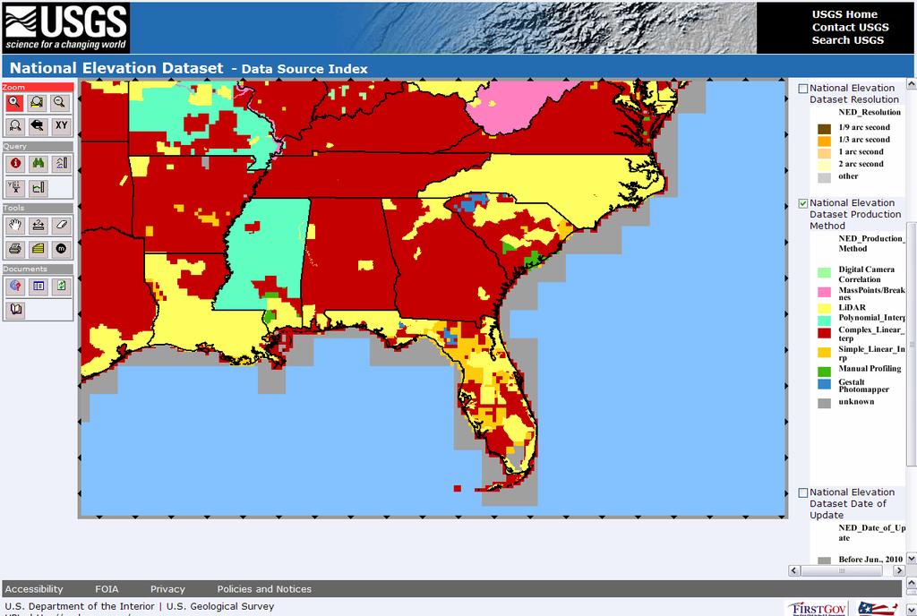
14 USGS NED Source Tool ned.usgs.gov/usgs_gn_ned_dsi/

15 USGS CLICK Data Availability lidar.cr.usgs.gov


16 Digital Coast Data Availability

17 Topographic and Bathymetric Data Inventory

 www.")
18 National Digital Elevation Program Project Tracker Project types - Planned - In work - Recently completed Federal State (NSGIC) Harvested by Geospatial One Stop (GOS)
19 When It Comes to Flood Mapping or Sea Level Rise Projection, Elevation Data Is the Key National Research Council report Mapping the zone: Improving Flood Map Accuracy Topographic/bathymetric data is the most important factor in determining the accuracy of flood maps Climate Change Science Program SAP 4.1, Coastal Elevations and Sensitivity to Sea-Level Rise Sea level rise mapping requires high-resolution elevation data (Current national datasets {30m DEMs} are not adequate)

 Lidar data NED National")
20 Importance of Elevation Data Profile in Charleston, South Carolina 30-meter NED data (1 arc second) 10-meter NED data (1/3 arc second) Lidar data NED National Elevation Dataset
 LOWER!! The average difference between the 10m NED and the lidar is more than 2.")
21 In Charleston, South Carolina Vulnerable Areas Are Lower Than We Thought Up to 3 meters (10 feet) LOWER!! The average difference between the 10m NED and the lidar is more than 2.5m (8ft).
 0.5m Sea Level Rise 0.")
22 DEM Accuracy and Inundation Mapping 3m lidar DEM (VA=~20cm) 10m National Elevation Dataset DEM (VA=~1m) 0.5m Sea Level Rise 0.5m Sea Level Rise + 1 Root Mean Square Error (RMSE)


23 Build Best Terrain Available NED Digital Coast - JABLTCX Raw Points/Breaklines

24 Obtain Data and Create DEM
25 Enforce Hydro- Connectivity

26 Enforce Hydro- Connectivity

27 Enhance for Better Visualizations

28 5-meter Resolution Resolution Requirements 10-meter Resolution

29 Communicate Mapping Confidence Visualize the mapping confidence of inundation area based on uncertainty of elevation data and MHHW tidal surface.
Tracy Fuller U. S. Geological Survey. February 24, 2016
 U. S. Geological Survey Arctic Elevation Data Involvement Statewide Alaska IfSAR Radar Collection Program Pan-Arctic Digital Elevation Map International Coordination Tracy Fuller U. S. Geological Survey
If this is your first experience with LiDAR data you might want to check out the MGISAC s whitepaper on LiDAR here:
 IMPORTANT NOTE! If the LiDAR data products you re looking are not in the maps.wustl.edu / mo_lidar_data directory then it is either not available for public access yet - is in the pipeline to be posted
John Callahan (Delaware Geological Survey) Kevin Brinson, Daniel Leathers, Linden Wolf (Delaware Environmental Observing System)
 Kevin Brinson, Daniel Leathers, Linden Wolf (Delaware Environmental Observing System)") John Callahan (Delaware Geological Survey) Kevin Brinson, Daniel Leathers, Linden Wolf (Delaware Environmental Observing System) Delaware is extremely vulnerable to the impacts of coastal flooding Tropical
John Callahan (Delaware Geological Survey) Kevin Brinson, Daniel Leathers, Linden Wolf (Delaware Environmental Observing System) Delaware is extremely vulnerable to the impacts of coastal flooding Tropical
EXPERIENCE WITH HIGH ACCURACY COUNTY DTM MAPPING USING SURVEYING, PHOTOGRAMMETRIC, AND LIDAR TECHNOLOGIES - GOVERNMENT AND CONTRACTOR PERSPECTIVES
 EXPERIENCE WITH HIGH ACCURACY COUNTY DTM MAPPING USING SURVEYING, PHOTOGRAMMETRIC, AND LIDAR TECHNOLOGIES - GOVERNMENT AND CONTRACTOR PERSPECTIVES Barbora Ubar, Photogrammetrist Tim Brown, PSM, Senior
LiDAR APPLICATIONS REMS6090. Assignment 2 HYDROLOGICAL APPLICATIONS of LiDAR DATA Due Date April 8, Venessa Bennett W
 LiDAR APPLICATIONS REMS6090 Assignment 2 HYDROLOGICAL APPLICATIONS of LiDAR DATA Due Date April 8, 2015 Venessa Bennett W0279429 1.0 Introduction High accuracy Digital Elevation Models (DEM) derived from
Flood Hazard Zone Modeling for Regulation Development
 Flood Hazard Zone Modeling for Regulation Development By Greg Lang and Jared Erickson Pierce County GIS June 2003 Abstract The desire to blend current digital information with government permitting procedures,
Flood Inundation Mapping
 KU GIS Day 2009 November 18, 2009 Flood Inundation Mapping Wendy L. Pearson NOAA s National Weather Service Central Region Headquarters Kansas City, Missouri Flood Inundation Mapping Objectives: Overview
Base Level Engineering FEMA Region 6
 Base Level Engineering Over the past five years, has been evaluating its investment approach and data preparation work flow to establish an efficient and effective change in operation, generating an approach
Digital Elevation Model of Tutuila, American Samoa: Procedures, Data Sources, and Analysis
 Digital Elevation Model of Tutuila, American Samoa: Procedures, Data Sources, and Analysis Prepared for the National Tsunami Hazard Mitigation Program (NTHMP) by the NOAA National Geophysical Data Center
MISSOURI LiDAR Stakeholders Meeting
 MISSOURI LiDAR Stakeholders Meeting East-West Gateway June 18, 2010 Tim Haithcoat Missouri GIO Enhanced Elevation Data What s different about it? Business requirements are changing.fast New data collection
UPPER COSUMNES RIVER FLOOD MAPPING
 UPPER COSUMNES RIVER FLOOD MAPPING DRAFT BASIC DATA NARRATIVE FLOOD INSURANCE STUDY SACRAMENTO COUTY, CALIFORNIA Community No. 060262 November 2008 Prepared By: CIVIL ENGINEERING SOLUTIONS, INC. 1325 Howe
The 3D Elevation Program: Overview. Jason Stoker USGS National Geospatial Program ESRI 2015 UC
 + The 3D Elevation Program: Overview Jason Stoker USGS National Geospatial Program ESRI 2015 UC + 2 A little history USGS has a long, proud tradition of mapmaking (2009) + 3 The changing times Mapping
GeoWEPP Tutorial Appendix
 GeoWEPP Tutorial Appendix Chris S. Renschler University at Buffalo - The State University of New York Department of Geography, 116 Wilkeson Quad Buffalo, New York 14261, USA Prepared for use at the WEPP/GeoWEPP
Preliminary Data Release for the Humboldt Bay Sea Level Rise Vulnerability Assessment: Humboldt Bay Sea Level Rise Inundation Mapping
 Preliminary Data Release for the Humboldt Bay Sea Level Rise Vulnerability Assessment: Humboldt Bay Sea Level Rise Inundation Mapping Prepared by: Jeff Anderson, Northern Hydrology & Engineering (jeff@northernhydrology.com)
Application of high-resolution (10 m) DEM on Flood Disaster in 3D-GIS
 DEM on Flood Disaster in 3D-GIS") Risk Analysis V: Simulation and Hazard Mitigation 263 Application of high-resolution (10 m) DEM on Flood Disaster in 3D-GIS M. Mori Department of Information and Computer Science, Kinki University, Japan
Risk Analysis V: Simulation and Hazard Mitigation 263 Application of high-resolution (10 m) DEM on Flood Disaster in 3D-GIS M. Mori Department of Information and Computer Science, Kinki University, Japan
Bathymetry Data and Models: Best Practices
 Bathymetry Data and Models: Best Practices Barry Eakins & Lisa Taylor The NOAA National Geophysical Data Center Over 600 data types - from the core of the Earth to the surface of the Sun NGDC Bathymetry
3D Elevation Program- Status and Updates. Oklahoma GI Council Meeting November 2, 2018 Claire DeVaughan US Geological Survey
 + 1 3D Elevation Program- Status and Updates Oklahoma GI Council Meeting November 2, 2018 Claire DeVaughan US Geological Survey + 2 3D Elevation Program (3DEP) Goals Complete acquisition in 8 years Address
QUESNEL PEM DEM Digital Elevation Model Preparation. Summary Report
 2005-2006 QUESNEL PEM DEM Digital Elevation Model Preparation Summary Report Quesnel Contract # FIA4492005 Williams Lake Contract # FIA4497002 100 Mile House Contract # FIA4486006 Jan 20, 2006 Meridian
ENGRG Introduction to GIS
 ENGRG 59910 Introduction to GIS Michael Piasecki March 17, 2014 Lecture 08: Terrain Analysis Outline: Terrain Analysis Earth Surface Representation Contour TIN Mass Points Digital Elevation Models Slope
Remote Sensing / GIS Conference. The Louisiana Proposed Elevation for the Nation Business Plan Components
 Remote Sensing / GIS Conference 08 April 2008 The Louisiana Proposed Elevation for the Nation Business Plan Components David Gisclair, Louisiana Oil Spill Coordinators Office, Office of the Governor david.gisclair@la.gov
Lidar-derived Hydrography as a Source for the National Hydrography Dataset
 Lidar-derived Hydrography as a Source for the National Hydrography Dataset Lidar-Derived Hydrography, Bathymetry, and Topobathymetry in the National Hydrography Dataset and 3-Dimensional Elevation Program
Andrew Dolch October 2013 Revision 1.0
 LP360 Andrew Dolch Revision 1.0 l GeoCue has had a long association with the Pennsylvania State University (Penn State) where the John A. Dutton e-education program in the department of Geography uses
Modeling Coastal Change Using GIS Technology
 Emily Scott NRS 509 Final Report December 5, 2013 Modeling Coastal Change Using GIS Technology In the past few decades, coastal communities around the world are being threatened by accelerating rates of
By Joseph L. Jones, Tana L. Haluska, and David L. Kresch U.S. GEOLOGICAL SURVEY. Water-Resources Investigations Report
 Updating Flood Maps Efficiently Using Existing Hydraulic Models, Very-High- Accuracy Elevation Data, and a Geographic Information System A Pilot Study on the Nisqually River, Washington By Joseph L. Jones,
GIS APPLICATIONS IN SOIL SURVEY UPDATES
 GIS APPLICATIONS IN SOIL SURVEY UPDATES ABSTRACT Recent computer hardware and GIS software developments provide new methods that can be used to update existing digital soil surveys. Multi-perspective visualization
ENGRG Introduction to GIS
 ENGRG 59910 Introduction to GIS Michael Piasecki November 17, 2017 Lecture 11: Terrain Analysis Outline: Terrain Analysis Earth Surface Representation Contour TIN Mass Points Digital Elevation Models Slope
Summary Visualizations for Coastal Spatial Temporal Dynamics
 Summary Visualizations for Coastal Spatial Temporal Dynamics October 24 2011 Providence, RI Sidharth Thakur 1, Laura Tateosian 2, Helena Mitasova, Eric Hardin, and Margery Overton 1. sthakur@renci.org,
Summary of Available Datasets that are Relevant to Flood Risk Characterization
 Inter-Agency Characterization Workshop February 25-27, 2014 USACE Institute for Water Resources, Alexandria, VA, IWR Classroom Summary of Available Datasets that are Relevant to Characterization National
The Use of Geographic Information Systems to Assess Change in Salt Marsh Ecosystems Under Rising Sea Level Scenarios.
 The Use of Geographic Information Systems to Assess Change in Salt Marsh Ecosystems Under Rising Sea Level Scenarios Robert Hancock The ecological challenges presented by global climate change are vast,
Hydrologic Engineering Applications of Geographic Information Systems
 Hydrologic Engineering Applications of Geographic Information Systems Davis, California Objectives: The participant will acquire practical knowledge and skills in the application of GIS technologies for
Working with Digital Elevation Models and Digital Terrain Models in ArcMap 9
 Working with Digital Elevation Models and Digital Terrain Models in ArcMap 9 1 TABLE OF CONTENTS INTRODUCTION...3 WORKING WITH DIGITAL TERRAIN MODEL (DTM) DATA FROM NRVIS, CITY OF KITCHENER, AND CITY OF
USGS National Geospatial Program Understanding User Needs. Dick Vraga National Map Liaison for Federal Agencies July 2015
 + USGS National Geospatial Program Understanding User Needs Dick Vraga National Map Liaison for Federal Agencies July 2015 + Topics 2 Background Communities of Use User Surveys National Map Liaisons Partnerships
A Detailed Examination of DTM Creation Methods and Sources. Study Area Overview
 A Detailed Examination of DTM Creation Methods and Sources Adam Mosbrucker & Melinda Lamb Geography 593: Dec. 2 nd, 2010 Study Area Overview Mt. St. Helens -active volcano many eruptions in the past 30
Object Based Imagery Exploration with. Outline
 Object Based Imagery Exploration with Dan Craver Portland State University June 11, 2007 Outline Overview Getting Started Processing and Derivatives Object-oriented classification Literature review Demo
3D Elevation Program, Lidar in Missouri. West Central Regional Advanced LiDAR Workshop Ray Fox
 3D Elevation Program, Lidar in Missouri West Central Regional Advanced LiDAR Workshop Ray Fox National Enhanced Elevation Assessment (Dewberry, 2011) Sponsored by the National Digital Elevation Program
Creating a Bathymetric Database & Datum Conversion
 Creating a Bathymetric Database & Datum Conversion Mitchell Brown Civil Engineering Technician Mitchell.E.Brown@erdc.dren.mil June 11, 2012 US Army Corps of Engineers BUILDING STRONG Introduction to Bathymetric
Hydrologic and Hydraulic Analyses Using ArcGIS
 Hydrologic and Hydraulic Analyses Using ArcGIS Two day training class Overview ArcGIS and Arc Hydro provide strong foundation for support of hydrologic and hydraulic (H&H) analyses. This two-day course
Pictometry GIS and Integration Solutions. Presented by Peter White, GISP GIS Product Manager, Pictometry International Corp.
 Pictometry GIS and Integration Solutions Presented by Peter White, GISP GIS Product Manager, Pictometry International Corp. 1. Pictometry Web Integration Solutions 2. Advanced LiDAR Sensor and Solutions
Positional accuracy of the drainage networks extracted from ASTER and SRTM for the Gorongosa National Park region - Comparative analysis
 Positional accuracy of the drainage networks extracted from ASTER and SRTM for the Gorongosa National Park region - Comparative analysis Tiago CARMO 1, Cidália C. FONTE 1,2 1 Departamento de Matemática,
A Simple Drainage Enforcement Procedure for Estimating Catchment Area Using DEM Data
 A Simple Drainage Enforcement Procedure for Estimating Catchment Area Using DEM Data David Nagel, John M. Buffington, and Charles Luce U.S. Forest Service, Rocky Mountain Research Station Boise Aquatic
Digital Elevation Models (DEM)
") Digital Elevation Models (DEM) Digital representation of the terrain surface enable 2.5 / 3D views Rule #1: they are models, not reality Rule #2: they always include some errors (subject to scale and data
Digital Elevation Models (DEM) Digital representation of the terrain surface enable 2.5 / 3D views Rule #1: they are models, not reality Rule #2: they always include some errors (subject to scale and data
Development of Operational Storm Surge Guidance to Support Total Water Predictions
 Development of Operational Storm Surge Guidance to Support Total Water Predictions J. Feyen 1, S. Vinogradov 1,2, T. Asher 3, J. Halgren 4, Y. Funakoshi 1,5 1. NOAA/NOS//Development Laboratory 2. ERT,
ARMSTRONG COUNTY, PA
 ARMSTRONG COUNTY, PA Revised Preliminary DFIRM Mapping March 31, 2013 Kevin Donnelly, P.E., CFM GG3, Greenhorne & O Mara, Inc. Presentation Agenda Armstrong County DFIRM Overview - June 25, 2010 DFIRM
The Illinois Height Modernization Program: Improving Elevation Data for Illinois
 The Illinois Height Modernization Program: Improving Elevation Data for Illinois Bev Herzog and Sheen Beaverson Illinois State Geological Survey Institute for Natural Resource Sustainability University
Xiaojun Yang a a Department of Geography, Florida State University, Tallahassee, FL32306, USA Available online: 22 Feb 2007
 This article was downloaded by: [USGS Libraries Program] On: 29 May 2012, At: 15:41 Publisher: Taylor & Francis Informa Ltd Registered in England and Wales Registered Number: 1072954 Registered office:
LiDAR Quality Assessment Report
 LiDAR Quality Assessment Report The USGS National Geospatial Technical Operations Center, Data Operations Branch is responsible for conducting reviews of all Light Detection and Ranging (LiDAR) pointcloud
LOMR SUBMITTAL LOWER NESTUCCA RIVER TILLAMOOK COUNTY, OREGON
 LOMR SUBMITTAL LOWER NESTUCCA RIVER TILLAMOOK COUNTY, OREGON Prepared for: TILLAMOOK COUNTY DEPARTMENT OF COMMUNITY DEVELOPMENT 1510-B THIRD STREET TILLAMOOK, OR 97141 Prepared by: 10300 SW GREENBURG ROAD,
Erin Costello A comparison of Solar Radiation Modeling Tools
 Erin Costello A comparison of Solar Radiation Modeling Tools The Oregon Department of Environmental Quality uses effective shade as an indicator of water quality parameters as well as a target for restoration
ACCURACY ANALYSIS OF SRTM HEIGHT MODELS INTRODUCTION
 ACCURACY ANALYSIS OF SRTM HEIGHT MODELS Ricardo Passini(*), Karsten Jacobsen(**) (*)BAE SYSTEMS 124 Gaither Dr.,Suite 100, Mount Laurel, NJ 08054, USA ricardo.passini@baesystems.com (**)Institute of Photogrammetry
Floodplain Mapping & Flood Warning Applications in North Carolina
 Floodplain Mapping & Flood Warning Applications in North Carolina Marc Stanard, IT Project Manager Ken Ashe, Assistant Director David Herlong, Flood Warning Program Manager NC Crime Control & Public Safety
Adaptation to Sea Level Rise A Regional Approach
 Adaptation to Sea Level Rise A Regional Approach Project Partners: in Saco Bay, ME Peter Slovinsky, Marine Geologist Maine Geological Survey, Department of Conservation Project Funding from: Saco Bay Hazards
Name NRS 409 Exam I. 1. (24 Points) Consider the following questions concerning standard data for GIS systems.
 Consider the following questions concerning standard data for GIS systems.") Read every question carefully. You may use a calculator if you wish. Conversion tables are provided at the end of the exam. If you have any questions, raise your hand. Be sure to show your work on computational
Read every question carefully. You may use a calculator if you wish. Conversion tables are provided at the end of the exam. If you have any questions, raise your hand. Be sure to show your work on computational
Designing a Dam for Blockhouse Ranch. Haley Born
 Designing a Dam for Blockhouse Ranch Haley Born CE 394K GIS in Water Resources Term Paper Fall 2011 Table of Contents Introduction... 1 Data Sources... 2 Precipitation Data... 2 Elevation Data... 3 Geographic
Calhoun County, Texas Under 5 Meter Sea Level Rise
 Kyle Kacal GEO 327G Calhoun County, Texas Under 5 Meter Sea Level Rise PROBLEM AND PURPOSE: Sea level rise is threat to all coastal areas. Although natural sea level rise happens at a very slow rate, hurricanes
Floodplain and Flood Probability Mapping Using Geodatabases
 Brigham Young University BYU ScholarsArchive All Theses and Dissertations 2005-03-16 Floodplain and Flood Probability Mapping Using Geodatabases Douglas J. Gallup Brigham Young University - Provo Follow
Using the Stock Hydrology Tools in ArcGIS
 Using the Stock Hydrology Tools in ArcGIS This lab exercise contains a homework assignment, detailed at the bottom, which is due Wednesday, October 6th. Several hydrology tools are part of the basic ArcGIS
Emergency Planning. for the. Democratic National. Convention. imaging notes // Spring 2009 //
 Emergency Planning for the Democratic National Convention The DRAPP Demonstrates Partnership among Local, Regional, State, Utility and Federal Governments 14 imaging notes // Spring 2009 // www.imagingnotes.com
BECQ 2017 SLR Map Layer Updates: Methodology for Coastal Flood Geoprocessing
 BECQ 2017 SLR Map Layer Updates: Methodology for Coastal Flood Geoprocessing This paper summarizes the local and regional sea level data used to develop coastal flooding scenarios for the island of Saipan,
Background. Points of Discussion. Hydrographic Models
 Airborne Laser Remote Sensing Technology: Providing Essential Hydrologic Information in the 21 st Century Warwick Hadley, Optech Incorporated Presented by: Warwick Hadley Sales Manager, Middle East and
What s New in Topographic Information - USGS National Map
 + What s New in Topographic Information - USGS National Map SARGIS Workshop November 14, 2016 Rob Dollison, 703-648-5724 rdollison@usgs.gov + USGS 2 National Geospatial Program The National Geospatial
Flow regime, floodplain inundation and floodplain waterbody connectivity at Congaree National Park
 Flow regime, floodplain inundation and floodplain waterbody connectivity at Congaree National Park John Kupfer Dept. of Geography Univ. of South Carolina Kimberly Meitzen Duke University Nature Conservancy
Name NRS 509 Exam I. Right Map
 Read every question carefully. You may use a calculator if you wish. Conversion tables are provided at the end of the exam. If you have any questions, raise your hand. Be sure to show your work on computational
OLC Rogue River. LiDAR Remote Sensing Data Final Report, 3 of 3
 OLC Rogue River LiDAR Remote Sensing Data Final Report, 3 of 3 November 5, 2012 Rogue River Valley, Oregon. Data collected for: Department of Geology and Mineral Industries 800 NE Oregon Street Suite 965
Topographic Maps. More than a Road Map
 Topographic Maps More than a Road Map What is a Topographic Map? Scaled representation of features on the surface of the Earth such as roads, rivers, and plains Provides information about land elevations
USGS Flood Inundation Mapping of the Suncook River in Chichester, Epsom, Pembroke and Allenstown, New Hampshire
 USGS Flood Inundation Mapping of the Suncook River in Chichester, Epsom, Pembroke and Allenstown, New Hampshire NH Water & Watershed Conference Robert Flynn, USGS NH-VT Water Science Center March 23, 2012
ELEVATION IS FOUNDATIONAL. A DEM that is inaccurate or of poor resolution will pass those characteristics onto other data layers
 ELEVATION IS FOUNDATIONAL A DEM that is inaccurate or of poor resolution will pass those characteristics onto other data layers THE DEM IS FOUNDATIONAL TO ALL GIS (Geospatial Information System) LAYERS
Breaking the 5 Mile per Hour Barrier: Automated Mapping Using a Normal Depth Calculation
 Breaking the 5 Mile per Hour Barrier: Automated Mapping Using a Normal Depth Calculation Jeffrey T. Shafer, P.E. and James R. Williams, P.E. Nebraska Department of Natural Resources Introduction In 1998,
South Florida Coastal Storm Surge and Mapping Study
 South Florida Coastal Storm Surge and Mapping Study Presented by Christopher Bender, Ph.D., P.E., D.CE June 2, 2015 Presentation Overview FEMA risk studies outline Overview South Florida surge study Work
Summary Description Municipality of Anchorage. Anchorage Coastal Resource Atlas Project
 Summary Description Municipality of Anchorage Anchorage Coastal Resource Atlas Project By: Thede Tobish, MOA Planner; and Charlie Barnwell, MOA GIS Manager Introduction Local governments often struggle
North Carolina Simplified Inundation Maps For Emergency Action Plans December 2010; revised September 2014; revised April 2015
 North Carolina Simplified Inundation Maps For Emergency Action Plans December 2010; revised September 2014; revised April 2015 INTRODUCTION Emergency Action Plans (EAPs) are critical to reducing the risks
Appendix J Vegetation Change Analysis Methodology
 Appendix J Vegetation Change Analysis Methodology Regional Groundwater Storage and Recovery Project Draft EIR Appendix-J April 2013 APPENDIX J- LAKE MERCED VEGETATION CHANGE ANALYSIS METHODOLOGY Building
Generation and analysis of Digital Elevation Model (DEM) using Worldview-2 stereo-pair images of Gurgaon district: A geospatial approach
 using Worldview-2 stereo-pair images of Gurgaon district: A geospatial approach") 186 Generation and analysis of Digital Elevation Model (DEM) using Worldview-2 stereo-pair images of Gurgaon district: A geospatial approach Arsad Khan 1, Sultan Singh 2 and Kaptan Singh 2 1 Department
186 Generation and analysis of Digital Elevation Model (DEM) using Worldview-2 stereo-pair images of Gurgaon district: A geospatial approach Arsad Khan 1, Sultan Singh 2 and Kaptan Singh 2 1 Department
Karamea floodplain investigation
 Karamea floodplain investigation NIWA Client Report: CHC2010-107 October 2010 NIWA Project: ELF 10234/1 Karamea floodplain investigation Graeme Smart Jo Bind NIWA contact/corresponding author Graeme Smart
Zone A Modeling (What Makes A Equal Approximate, Adequate, or Awesome)
") Zone A Modeling (What Makes A Equal Approximate, Adequate, or Awesome) ASFPM 2016 GRAND RAPIDS CONFERENCE Kevin Donnelly, P.E., GISP, PMP, CFM June 23, 2016 Agenda 1 Introduction 2 Flood Hazard Analysis
Zone A Modeling (What Makes A Equal Approximate, Adequate, or Awesome) ASFPM 2016 GRAND RAPIDS CONFERENCE Kevin Donnelly, P.E., GISP, PMP, CFM June 23, 2016 Agenda 1 Introduction 2 Flood Hazard Analysis
The Coastal Change Analysis Program and the Land Cover Atlas. Rebecca Love NOAA Office for Coastal Management
 The Coastal Change Analysis Program and the Land Cover Atlas Rebecca Love NOAA Office for Coastal Management Natural Infrastructure = Greater Resilience NOAA C-CAP Regional Land Cover and Change coast.noaa.gov/digitalcoast/data/ccapregional
Image Services Providing Access to Scientific Data at NOAA/NCEI
 Image Services Providing Access to Scientific Data at NOAA/NCEI Jesse Varner Cooperative Institute for Research in Environmental Sciences (CIRES), University of Colorado John Cartwright NOAA National Centers
1. The topographic map below shows a depression contour line on Earth's surface.
 1. The topographic map below shows a depression contour line on Earth's surface. Points A, B, C, and D represent surface locations. Contour line elevations are in feet. Which profile best shows the topography
A critique of the National Standard for Spatial Data Accuracy. Paul Zandbergen Department of Geography University of New Mexico
 A critique of the National Standard for Spatial Data Accuracy Paul Zandbergen Department of Geography University of New Mexico Warning: Statistics Ahead! Spatial Data Quality Matters! Plane took off on
TRB First International Conference on Surface Transportation Resilience
 TRB First International Conference on Surface Transportation Resilience Applying the Sea-Level Scenario Sketch Planning Tool to Enhance the Resilience of Long-Range Transportation Plans: Lessons Learned
Management and Use of LiDAR-derived Information. Elizabeth Cook, GIS Specialist
 Management and Use of LiDAR-derived Information Elizabeth Cook, GIS Specialist Advanced LiDAR Workshop March 15, 2012 50-100 gb/county Now What? Project Deliverables LAS mass point files, classification
Preliminary Vulnerability Assessment of Coastal Flooding Threats - Taylor County, Florida
 Preliminary Vulnerability Assessment of Coastal Flooding Threats - Taylor County, Florida North Central Florida Regional Planning Council Northeast Florida Regional Council April 28, 2016 BACKGROUND This
Rapid Flood Mapping Using Inundation Libraries
 Rapid Flood Mapping Using Inundation Libraries Jude Kastens, Kevin Dobbs, James Halgren, Katherine Balster 2017 ASFPM Conference May 3, 2017 5 mi Kansas River Valley between Manhattan and Topeka Email:
QUESTIONNAIRE THE CURRENT STATUS OF MAPPING IN THE WORLD
 QUESTIONNAIRE ON THE CURRENT STATUS OF MAPPING IN THE WORLD The questionnaire is intended to take stock of the current status of mapping in the world. The information collected will eventually be used
Timothy P. Morrissey. Chapel Hill Approved By: Dr. Stephen J. Walsh. Dr. Conghe Song. Dr. Xiaodong Chen
 NCResSys: A Geospatial Modeling Information System for the Identification of Potential Municipal Water Supply Reservoir Locations across the State of North Carolina Timothy P. Morrissey A thesis submitted
3/29/11. Why bother with tools? Incorporating Decision Support Tools into Climate Adaptation Planning. A Simplified Planning Process
 Incorporating Decision Support Tools into Climate Adaptation Planning Why bother with tools? Tools don t eliminate complexity but they can help deal with it" Tools can:"! Help incorporate science into
Popular Mechanics, 1954
 Introduction to GIS Popular Mechanics, 1954 1986 $2,599 1 MB of RAM 2017, $750, 128 GB memory, 2 GB of RAM Computing power has increased exponentially over the past 30 years, Allowing the existence of
A SIMPLE GIS METHOD FOR OBTAINING FLOODED AREAS
 A SIMPLE GIS METHOD FOR OBTAINING FLOODED AREAS ROMAN P., I. 1, OROS C., R. 2 ABSTRACT. A simple GIS method for obtaining flooded areas. This paper presents a method for obtaining flooded areas near to
Coastal Emergency Risks Assessment - CERA Real-Time Storm Surge and Wave Visualization Tool
 Coastal Emergency Risks Assessment - CERA Real-Time Storm Surge and Wave Visualization Tool Introduction This document provides guidance for using the Coastal Emergency Risks Assessment (CERA) visualization
USGS Data Initiatives for Elevation, Streams and Topo Maps
 USGS Data Initiatives for Elevation, Streams and Topo Maps Gary Merrill, USGS Geospatial Liaison for Carolinas Silvia Terziotti, USGS Assoc. Geospatial Liaison for North Carolina, Water Communities of
GRAPEVINE LAKE MODELING & WATERSHED CHARACTERISTICS
 GRAPEVINE LAKE MODELING & WATERSHED CHARACTERISTICS Photo Credit: Lake Grapevine Boat Ramps Nash Mock GIS in Water Resources Fall 2016 Table of Contents Figures and Tables... 2 Introduction... 3 Objectives...
Great Lakes Update. Geospatial Technologies for Great Lakes Water Management. Volume 149 October 4, US Army Corps of Engineers Detroit District
 Volume 149 October 4, 2002 US Army Corps of Engineers Detroit District Great Lakes Update Geospatial Technologies for Great Lakes Water Management The U.S. Army Corps of Engineers (USACE) serves an important
Effects of Rising Sea Levels on Coral Reef and Mangrove Distributions along the Great Barrier Reef in Australia
 Effects of Rising Sea Levels on Coral Reef and Mangrove Distributions along the Great Barrier Reef in Australia Sarah Barfield Graduate Student Department of Integrative Biology University of Texas, Austin
EVALUATION OF VECTOR COASTLINE FEATURES EXTRACTED FROM STRUCTURE FROM MOTION -DERIVED ELEVATION DATA
 1 EVALUATION OF VECTOR COASTLINE FEATURES EXTRACTED FROM STRUCTURE FROM MOTION -DERIVED ELEVATION DATA NICOLE KINSMAN 1, ANN GIBBS 2, MATT NOLAN 3 1. Alaska Division of Geological & Geophysical Surveys,
Office of Geographic Information Systems
 Winter 2007 Department Spotlight SWCD GIS by Dave Holmen, Dakota County Soil and Water Conservation District The Dakota County Soil and Water Conservation District (SWCD) has collaborated with the Dakota
GIS & Remote Sensing in Mapping Sea-Level Rise (SLR)
") Joe McGuire NRS-509 Concepts in GIS & Remote Sensing Professors August & Wang Due 12/10/2015 11:30am GIS & Remote Sensing in Mapping Sea-Level Rise (SLR) The ever-present threat of global warming and a
Joe McGuire NRS-509 Concepts in GIS & Remote Sensing Professors August & Wang Due 12/10/2015 11:30am GIS & Remote Sensing in Mapping Sea-Level Rise (SLR) The ever-present threat of global warming and a
GREENE COUNTY, PA. Revised Preliminary DFIRM Mapping FEMA. Kevin Donnelly, P.E., CFM GG3, Greenhorne & O Mara, Inc. April 10, 2013
 GREENE COUNTY, PA Revised Preliminary DFIRM Mapping April 10, 2013 Kevin Donnelly, P.E., CFM GG3, Greenhorne & O Mara, Inc. Presentation Agenda Greene County DFIRM Overview September 30, 2010 DFIRM Countywide
Manitoba s Elevation (LiDAR) & Imagery Datasets. Acquisition Plans & Opportunities for Collaboration
 & Imagery Datasets. Acquisition Plans & Opportunities for Collaboration") Manitoba s Elevation (LiDAR) & Imagery Datasets Acquisition Plans & Opportunities for Collaboration Manitoba Planning Conference May 2017 Presentation Outline Manitoba s Elevation (LiDAR) and Imagery Datasets
Manitoba s Elevation (LiDAR) & Imagery Datasets Acquisition Plans & Opportunities for Collaboration Manitoba Planning Conference May 2017 Presentation Outline Manitoba s Elevation (LiDAR) and Imagery Datasets
Effects of input DEM data spatial resolution on Upstream Flood modeling result A case study in Willamette river downtown Portland
 Effects of input DEM data spatial resolution on Upstream Flood modeling result A case study in Willamette river downtown Portland By Hue Duong GEOG 593 Fall 2015 Digital Terrain Analysis Photo: Anh Duc
CENTRAL TEXAS HILL COUNTRY FLOOD
 CENTRAL TEXAS HILL COUNTRY FLOOD Term project report DECEMBER 7, 2018 UNIVERSITY OF TEXAS AT AUSTIN CE394K: GIS in Water Resources Engineering RIFAAI Mohamed Talha Table of Contents Introduction... 3 Context...
An analysis of storm surge attenuation by wetlands using USGS, FEMA, and NASA data
 An analysis of storm surge attenuation by wetlands using USGS, FEMA, and NASA data Pat Fitzpatrick Geosystems Research Institute Mississippi State University Walter Peterson and Courtney Buckley NASA Marshall