Outline of presentation
|
|
|
- Robyn Wood
- 5 years ago
- Views:
Transcription
 Receipt of recommendations and establishing a new outer in the PAP Peter")

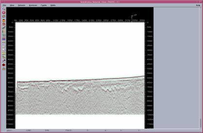
1 - lessons learnt from precedent cases of establishing the s Outline of presentation Extending Ireland s continental shelf jurisdiction to the outer s in the Porcupine Abyssal Plain: progress, issues and experience to date The Continental Shelf Delineation Project The partial submission for the Porcupine Abyssal Plain (PAP) Receipt of recommendations and establishing a new outer in the PAP Peter F. Croker Petroleum Affairs Division Department of Communications, Energy and Natural Resources Dublin Ireland Prospectivity of the PAP for natural resources Licensing issues Article 82 of UNCLOS Protection of the marine environment A north atlantic view 1 2 S.I No. 163 of 2009 Copyright United Nations, 2000 History of Continental Shelf Designations by Ireland PAD 1995 Seismic Survey 4,121 line km 58 days 71 km/day Average speed of 1.6kts Operational speed 4.5kts PAD 1995 Continental Shelf Seismic Survey M/V Akademik Shatskiy Acquisition Parameters Contractor: General Information ACQUIRED BY SCHLUMBERGER/G-P VESSEL AKADEMIK SHATSKIY DATE Length: JULY m Draught: 5.4m Recording Port of Specifications: Registry: Murmansk INSTRUMENTS NESSIE 3 Owner: SMNG (Sevmorneftegeofizika) LO-CUT FILTER 3 Hz / 18 db Contractor: Schlumberger Geco-Prakla Survey Source: Statistics ARRAY TYPE: CLUSTER ARRAYS TAPE FORMAT SEG D NO OF CHANNELS 320 HI-CUT FILTER 125 Hz /70dB/Oct RECORD LENGTH 10.0 Secs SAMPLE INT. 2.0 ms ARRAY VOLUME 2368 cu. in. Start/end ARRAY PRESSURE of survey: 2000 psi 3 rd July/29 th August, 1995 SOURCE DEPTH 8 m Total no. of days: 58 days TIMING ERROR +/- 1.5 ms Total Cable: line length: 4121km TYPE DIGITAL NESSIE3 Total cost: IR 1,496,167 (est.) GROUP LENGTH m Budgeted cost: IR 1,476,000 GROUP INTERVAL 12.5 m Data CABLE recorded: LENGTH m Gigabytes CABLE DEPTH 12 m 5 6


 7 8 Submitted 25 May 2005 Submitted 19 May 2006 9 10 Designated continental shelf continental shelf Submitted 31 March 2009 HRA coordinated")

2 - lessons learnt from precedent cases of establishing the s PAD 1996 Multibeam Survey 30,094 line km 128 days 235 km/day 231,000 sq km Average speed of 5.3kts PAD 1996 Continental Shelf Bathymetric Survey Operational speed 9kts Swathe Bathymetry System: Simrad EM12S Multibeam Echosounder Frequency 13kHz M/V Ocean Surveyor No of transmitters 384 Max total power 10kW General Information Survey Statistics Pulse length 1, 2 or 10ms Max source level 236dB Stabilization Length: Pitch 83.5m and roll Start/end of survey: 20 th May/24 th September, 1996 Bandwidth Draught: 1.5kHz 5.3m Total no. of days: 128 days Swath width 90 deg stabilised Port of Registry: Panama Total line length: 30,094km No of receive beams 81 Beam spacing Owner: Louis Dreyfus Total cost: IR 1,794,122 Echo Sounder: Contractor: Simrad EK500 Geoteam-Wimpol Budgeted cost: IR 1,813,500 Sound Velocity Meter: ML SVP/CDT plus Sippican XBT, XSV disposable probes Sub-bottom Profiler: Hull mounted 4 x 4 ORE 3.5kHz Data recorded: 45 million depth soundings (1.5 GB) 7 8 Submitted 25 May 2005 Submitted 19 May Designated continental shelf continental shelf Submitted 31 March 2009 HRA coordinated submission made March 2009 Recommendations expected?? PAP partial submission made May 2005 Recommendations received April 2007 Area designated under CS Act March 2009 FISU joint submission made May 2006 Recommendations received April 2009 Deation negotiations began in October 2010 Ireland s outer continental shelf s and status of submissions to the CLCS, November


3 - lessons learnt from precedent cases of establishing the s Globe image copyright ESRI, 2010 All areas of Ireland s designated continental shelf beyond remain closed to licensing for oil and gas exploration OL Unnamed seamount 17 18


4 - lessons learnt from precedent cases of establishing the s WAM DSDP 550 Copyright IHRDC,
")
 25 26 Generalised bathymetry Summary of PAP")


 1.")


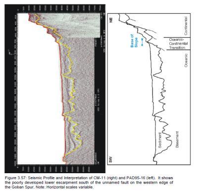
5 - lessons learnt from precedent cases of establishing the s Gas hydrates slide (figures from Mac Aodha, 2005) Diagrams from Waples & de Graciansky et al DSDP Volume 80 (1985) Generalised bathymetry Summary of PAP prospectivity for natural resources UNCLOS OSPAR EU National Oil No Gas No Gas hydrate No Minerals?? UNCLOS OSPAR National Article 82 Payments and contributions with respect to the exploitation of the continental shelf beyond 200 nautical miles (parts 1 and 2 only) 1. The coastal State shall make payments or contributions in kind in respect of the exploitation of the non-living resources of the continental shelf beyond 200 nautical miles from the baselines from which the breadth of the territorial sea is measured. 2. The payments and contributions shall be made annually with respect to all production at a site after the first five years of production at that site. For the sixth year, the rate of payment or contribution shall be 1 per cent of the value or volume of production at the site. The rate shall increase by 1 per cent for each subsequent year until the twelfth year and shall remain at 7 per cent thereafter. Production does not include resources used in connection with exploitation. Part of Table 1 from ISA Technical Study No. 5,
, and offshore SACs (red")


6 - lessons learnt from precedent cases of establishing the s Location of carbonate mounds (Croker & O Loughlin, 1998, 2002), and offshore SACs (red arrows). David T. Sandwell and Walter H.F. Smith, Marine Gravity Anomaly from Satellite Altimetry, Version M 1190M 2900M David T. Sandwell and Walter H.F. Smith, Marine Gravity Anomaly from Satellite Altimetry, Version 18.1 EEZ zones and Limits submitted to the CLCS in the North Atlantic (October 2010) 35 36
, plus")
 GEBCO bathymetry, zones, submissions to CLCS (October")
, OSPAR MPAs, Canada drilling, 9 February")
7 - lessons learnt from precedent cases of establishing the s EEZ zones and Limits submitted to the CLCS in the North Atlantic (October 2010), plus multibeam GEBCO bathymetry, zones GEBCO bathymetry, zones, submissions to CLCS (October 2010) GEBCO bathymetry, zones, submissions to CLCS (October 2010), OSPAR MPAs Canada-Ireland seismic section GEBCO bathymetry, zones, submissions to CLCS (October 2010), OSPAR MPAs, Canada drilling, 9 February licensing

8 Gap Seminar on Extension of the Continental Shelf and National Ocean Policy - lessons learnt from precedent cases of establishing the s Thank you for your attention Ireland s outer continental shelf s and PAD, INSS and INFOMAR multibeam tracklines 43 44
IRELAND. PART I Executive Summary
 IRELAND Submission to the Commission on the Limits of the Continental Shelf pursuant to Article 76, paragraph 8 of the United Nations Convention on the Law of the Sea 1982 in respect of the area abutting
The french national programme for claiming continental shelf beyond 200 Miles
 The french national programme for claiming continental shelf beyond 200 Miles Using global bathymetric models in the context of an Extended Continental Shelf submission EXTRAPLAC Using Global Bathymetric
Indonesia Frontier Basin SUNDA (SU-08) NON-EXCLUSIVE 2-D SURVEY 3084km
 NON-EXCLUSIVE 2-D SURVEY 3084km") Indonesia Frontier Basin SUNDA (SU-08) NON-EXCLUSIVE 2-D SURVEY 3084km SEISMIC ACQUISITION PARAMETERS Acquisition Date: January - March 2008 Vessel: M/V Osprey Explorer Shooting Orientation: Strike-Dip
Indonesia Frontier Basin SUNDA (SU-08) NON-EXCLUSIVE 2-D SURVEY 3084km SEISMIC ACQUISITION PARAMETERS Acquisition Date: January - March 2008 Vessel: M/V Osprey Explorer Shooting Orientation: Strike-Dip
CONTINENTAL SHELF SUBMISSION OF ANGOLA - EXECUTIVE SUMMARY -
 CONTINENTAL SHELF SUBMISSION OF ANGOLA - EXECUTIVE SUMMARY - INDEX List of Figures 2 List of Tables 3 1 Introduction 5 2 Provisions of Article 76 7 3 Angolan Institutions responsible for the Submission
UNCLOS Article 76- Formulae and constraint lines
 UNCLOS Article 76- Formulae and constraint lines Dr Lindsay Parson (UNCLOS Group, National Oceanography Centre, UK) ABLOS TUTORIAL SESSION - Article 76 of UNCLOS 10th October 2005 IHO/IAG/IOC Advisory
APPENDIX 1 Figures 1-7
 APPENDIX 1 Figures 1-7 Figure 1: Three dimensional view of the continental margin adjacent to the Republic of in the eastern central Atlantic Ocean. Names of primary submarine features (from GEBCO) are
Challenges of Collecting Data for Article 76 in Ice Covered Waters of the Arctic
 Challenges of Collecting Data for Article 76 in Ice Covered Waters of the Arctic 5 th ABLOS Conference Monaco October 16, 2008 Richard MacDougall - Canada Jacob Verhoef - Canada Wendell Sanford - Canada
Ocean Basins, Bathymetry and Sea Levels
 Ocean Basins, Bathymetry and Sea Levels Chapter 4 Please read chapter 5: sediments for next class and start chapter 6 on seawater for Thursday Basic concepts in Chapter 4 Bathymetry the measurement of
Law of the Sea Symposium, February, 2016, TOKYO International Law for the Resources of the Sea
 Law of the Sea Symposium, 16-17 February, 2016, TOKYO International Law for the Resources of the Sea Segment 2 Governance of Resources of the Continental Shelf (including extended continental shelf) Introduction
THE MEASUREMENT AND ANALYSIS OF BATHYMETRY, MORPHOLOGY, AND SEDIMENT THICKNESS
 THE MEASUREMENT AND ANALYSIS OF BATHYMETRY, MORPHOLOGY, AND SEDIMENT THICKNESS Ron Macnab Geological Survey of Canada (Retired) OUTLINE OF PRESENTATION Principles and practice of: Echo-sounding Seismic
Portuguese Task Group for the Extension of the Continental Shelf (EMEPC)
") Portuguese Task Group for the Extension of the Continental Shelf (EMEPC) Teresa Rafael November 13 th 2017 DGRM Agenda 1. EMEPC competences 2. Initial Assessment Report - Extended continental shelf 3.
Portuguese Task Group for the Extension of the Continental Shelf (EMEPC) Teresa Rafael November 13 th 2017 DGRM Agenda 1. EMEPC competences 2. Initial Assessment Report - Extended continental shelf 3.
Preliminary Information Indicative of the Outer Limits of the Continental Shelf Beyond 200 Nautical Miles of the People s Republic of China
 (Translation) Preliminary Information Indicative of the Outer Limits of the Continental Shelf Beyond 200 Nautical Miles of the People s Republic of China 1. The People s Republic of China ratified the
Article 76, variations in annotation and implementation seen in submission documents for the claim of Extended Continental Shelf
 Article 76, variations in annotation and implementation seen in submission documents for the claim of Extended Continental Shelf Mr. Shin Tani Chairman, IHO/IAG Advisory Board on the Law of the Sea (ABLOS)
Bathymetric data acquisition in Arctic waters
 Bathymetric data acquisition in Arctic waters within the Danish Continental Shelf Project Morten Sølvsten, Uni Bull, Richard Pedersen & Christian Marcussen Arctic-Antarctic Seafloor Mapping Meeting 2011
High resolution geoid from altimetry & bathymetry: requirements for a future mission
 High resolution geoid from altimetry & bathymetry: requirements for a future mission The GRAL team: J-Y Royer 1,2, M-F Lalancette 3, G Louis 1,2, M Maia 1,2, D Rouxel 3 & L Géli 4 Project funded by 1 2
EXECUTIVE SUMMARY A SUBMISSION OF DATA AND INFORMATION ON THE OUTER LIMITS OF THE CONTINENTAL SHELF OF THE REPUBLIC OF NIGERIA PURSUANT TO
 EXECUTIVE SUMMARY A SUBMISSION OF DATA AND INFORMATION ON THE OUTER LIMITS OF THE CONTINENTAL SHELF OF THE REPUBLIC OF NIGERIA PURSUANT TO PART VI OF AND ANNEX II TO THE UNITED NATIONS CONVENTION ON THE
Operating conditions in the Arctic: Data acquisition in the Arctic Ocean by the Continental Shelf Project of the Kingdom of Denmark
 Operating conditions in the Arctic: Data acquisition in the Arctic Ocean by the Continental Shelf Project of the Kingdom of Denmark By Christian Marcussen Geological Survey of Denmark and Greenland Danish
Marine Geospatial Software: Generating Economic Benefits from Hydrographic Data and Calculation of Maritime Boundaries
 Marine Geospatial Software: Generating Economic Benefits from Hydrographic Data and Calculation of Serge LEVESQUE and Alexis CARDENAS, Canada Key words: marine geospatial data, hydrography, economic benefits,
Future Ocean Floor Mapping: Ocean Stewardship & Initial Industry Contributions. U.S Hydro Galveston, TX March 23, 2017 David Millar - Fugro
 Future Ocean Floor Mapping: Ocean Stewardship & Initial Industry Contributions U.S Hydro 2017 - Galveston, TX March 23, 2017 David Millar - Fugro Presentation Outline The Need for Ocean Mapping GEBCO GEBCO
Linking Global and Regional Levels in the Management of Marine Areas Beyond National Jurisdiction
 Linking Global and Regional Levels in the Management of Marine Areas Beyond National Jurisdiction South Atlantic Region Session 4: «Experiences, Priorities and Opportunities in the South Atlantic and Indian
NOAA Nautical Charts and Coastal and Marine Spatial Planning. Meredith Westington Chief Geographer NOAA/NOS/Office of Coast Survey
 NOAA Nautical Charts and Coastal and Marine Spatial Planning Meredith Westington Chief Geographer NOAA/NOS/Office of Coast Survey Ocean Policy Task Force What is CMSP? A comprehensive, adaptive, integrated,
Pacific Islands Regional Maritime Boundaries Project
 Pacific Islands Regional Maritime Boundaries Project 31 st Star Conference, Nadi, FIJI 6-8 June 2016 Jens Kruger Head of Ocean & Coastal Geoscience Sector Andrick Lal Project Officer (Surveying) Emily
APPLICATION FOR THE CONSENT TO CONDUCT MARINE SCIENTIFIC RESEARCH IN AREAS UNDER NATIONAL JURISDICTION OF THE UNITED KINGDOM
 APPLICATION FOR THE CONSENT TO CONDUCT MARINE SCIENTIFIC RESEARCH IN AREAS UNDER NATIONAL JURISDICTION OF THE UNITED KINGDOM 1. General information Date: 27 th January 2011 1.1 Cruise name and/or number:
Legal Interpretation of Submarine Ridges & Submarine Elevations
 Legal Interpretation of Ridges & Article 76, paragraph 6 New Knowledge and Changing Circumstances in the Law of the Sea Reykjavik, Iceland June 28, 2018 Kevin Baumert U.S. Department of State U.S. ECS
Part I. Executive Summary
 Part I. Executive Summary Partial Submission of Data and Information on the Limits of the Continental Shelf of Spain to the West of the Canary Islands, pursuant to Part VI and Annex II of United Nations
Seafloor Mapping in the High Arctic: The Challenges and the Joys
 Seafloor Mapping in the High Arctic: The Challenges and the Joys Larry Mayer Center for Coastal and Ocean Mapping / NOAA- UNH Joint Hydrographic Center University of New Hampshire, USA Martin Jakobsson
Oceanography, An Invitation to Marine Science 9e Tom Garrison. Ocean Basins Cengage Learning. All Rights Reserved.
 Oceanography, An Invitation to Marine Science 9e Tom Garrison 4 Ocean Basins Key Concepts Tectonic forces shape the seabed The ocean floor is divided into continental margins and deep ocean basins The
GEOPHYSICAL SURVEYS: What are Seismic Surveys and How are They Done?
 GEOPHYSICAL SURVEYS: What are Seismic Surveys and How are They Done? Marine Geophysical Exploration Purpose Image the subsurface Evaluate the acreage Identify potential hydrocarbon accumulations Reducing
3. UNDERWAY GEOPHYSICS 1
 Sawyer, D.S., Whitmarsh, R.B., Klaus, A., et al., 1994 Proceedings of the Ocean Drilling Program, Initial Reports, Vol. 149 3. UNDERWAY GEOPHYSICS 1 Shipboard Scientific Party 2 EQUIPMENT AND METHODS Navigation
COMPLICATIONS IN DELIMITING THE OUTER CONTINENTAL SHELF. Ron Macnab Geological Survey of Canada (Retired)
") COMPLICATIONS IN DELIMITING THE OUTER CONTINENTAL SHELF Ron Macnab Geological Survey of Canada (Retired) DISCLAIMER The contents of this presentation are the author s personal views only, and do not represent
COMPLICATIONS IN DELIMITING THE OUTER CONTINENTAL SHELF Ron Macnab Geological Survey of Canada (Retired) DISCLAIMER The contents of this presentation are the author s personal views only, and do not represent
MARITIME PLANNING IN PORTUGAL
 MARITIME PLANNING IN PORTUGAL Marta Chantal Ribeiro 2 May 2007 In Portugal there is currently no strategic planning system in force for the maritime area as a whole The maritime area under Portuguese jurisdiction
Downloaded 09/29/16 to Redistribution subject to SEG license or copyright; see Terms of Use at
 Richard Wright*, James Carter, Ian Atkinson, Erin Gillis, Deric Cameron, and Leona Stead, Nalcor Energy Tom Neugebauer, TGS Jerry Witney, PGS Daniel Hughes and Michael Hall, Airbus Defence and Space Summary
STATISTICAL ANALYSIS FOR AUTOMATED SEEP EXTRACTION IN GIS
 STATISTICAL ANALYSIS FOR AUTOMATED SEEP EXTRACTION IN GIS Presented by Pamela Kanu, GISP ESRI USER CONFERENCE JULY 2017 SEEPS Seeps are natural gas and crude oil that enter the ocean through cracks and
Acoustic seafloor mapping systems. September 14, 2010
 Acoustic seafloor mapping systems September 14, 010 1 Delft Vermelding Institute onderdeel of Earth organisatie Observation and Space Systems Acoustic seafloor mapping techniques Single-beam echosounder
Map shows 3 main features of ocean floor
 Map shows 3 main features of ocean floor 2017 Pearson Education, Inc. Chapter 3 Marine Provinces 2017 Pearson Education, Inc. 1 Chapter 3 Overview The study of bathymetry determines ocean depths and ocean
Chapter Overview. Bathymetry. Measuring Bathymetry. Measuring Bathymetry
 CHAPTER 3 Marine Provinces Chapter Overview The study of bathymetry determines ocean depths and ocean floor topography. Echo sounding and satellites are efficient bathymetric tools. Most ocean floor features
Natura 2000 in the marine environment: state of implementation and next steps
 Life on the blue planet: biodiversity research and the new European marine policies EPBRS European Platform on Biodiversity Research Strategy Porto, Portugal 7-9 November 2007 Natura 2000 in the marine
JOINT SUBMISSION TO THE COMMISSION ON THE LIMITS OF THE CONTINENTAL SHELF BY TUVALU, THE REPUBLIC OF FRANCE AND NEW ZEALAND (TOKELAU)
") JOINT SUBMISSION TO THE COMMISSION ON THE LIMITS OF THE CONTINENTAL SHELF BY TUVALU, THE REPUBLIC OF FRANCE AND NEW ZEALAND (TOKELAU) TABLE OF CONTENTS i. PREFACE... iii ii. LIST OF FIGURES... iv iii.
JOINT SUBMISSION TO THE COMMISSION ON THE LIMITS OF THE CONTINENTAL SHELF BY TUVALU, THE REPUBLIC OF FRANCE AND NEW ZEALAND (TOKELAU) TABLE OF CONTENTS i. PREFACE... iii ii. LIST OF FIGURES... iv iii.
12/11/2013& egm502 seafloor mapping
 egm502 seafloor mapping lecture 13 multi-beam echo-sounders The majority of the current charts of the ocean floors have been produced from single beam echo-sounder data. Even though these data have been
Briefing document of the status of maritime boundaries in Pacific island countries
 Secretariat of the Pacific Community Seventh Heads of Fisheries Meeting (28 Feb. 4 March 2011, Noumea, New Caledonia) Working Paper 5 Original: English Briefing document of the status of maritime boundaries
The Future of Deep-Sea Mining
 Linking Global & Regional levels in the Management of Marine Areas Beyond National Jurisdiction FAO, Rome, 18-20 February 2015 The Future of Deep-Sea Mining David Johnson Seascape Consultants Ltd EU FP7
Recent developments in multi-beam echo-sounder processing at the Delft
 Recent developments in multi-beam echo-sounder processing at the Delft University of Technology Prof. Dr. Dick G. Simons Acoustic Remote Sensing Group, Faculty of Aerospace Engineering, Delft University
Bathymetry Measures the vertical distance from the ocean surface to mountains, valleys, plains, and other sea floor features
 1 2 3 4 5 6 7 8 9 10 11 CHAPTER 3 Marine Provinces Chapter Overview The study of bathymetry determines ocean depths and ocean floor topography. Echo sounding and satellites are efficient bathymetric tools.
PRELIMINARY INFORMATION
 PRELIMINARY INFORMATION INDICATIVE OF THE OUTER LIMITS OF THE CONTINENTAL SHELF AND DESCRIPTION OF THE STATUS OF PREPARATION OF MAKING A SUBMISSION TO THE COMMISSION ON THE LIMITS OF THE CONTINENTAL SHELF
The Bathymetry of the Central Mediterranean Sea in the framework of the EMODnet project a case study of bathymetric data integration and processing.
 The Bathymetry of the Central Mediterranean Sea in the framework of the EMODnet project a case study of bathymetric data integration and processing. Federica Foglini & Marzia Rovere CNR-ISMAR Institute
Lecture Outlines PowerPoint. Chapter 13 Earth Science 11e Tarbuck/Lutgens
 Lecture Outlines PowerPoint Chapter 13 Earth Science 11e Tarbuck/Lutgens 2006 Pearson Prentice Hall This work is protected by United States copyright laws and is provided solely for the use of instructors
The Continental Shelf Project: An overview of research activities in the Arctic Ocean on behalf of the Kingdom of Denmark
 The Continental Shelf Project: An overview of research activities in the Arctic Ocean on behalf of the Kingdom of Denmark Geological Survey of Denmark and Greenland Ministry of Climate and Energy John
Chapter 3 The Physical Setting
 Chapter 3 The Physical Setting Earth is a prolate ellipsoid, an ellipse of rotation, with an equatorial radius of R e =6, 378.1349 km (West, 1982) which is slightly greater than the polar radius of R p
Marine Spatial Planning in Hellas; Recent Facts and Perspectives
 XXV FIG CONGRESS Engaging the Challenges, Enhancing the Relevance Kuala Lumpur, Malaysia 16 21 June 2014 Marine Spatial Planning in Hellas; Recent Facts and Perspectives Mrs. Chaiditsa BOLANOU Surveying
The Ocean Floor Earth Science, 13e Chapter 13
 The Ocean Floor Earth Science, 13e Chapter 13 Stanley C. Hatfield Southwestern Illinois College The vast world ocean Earth is often referred to as the blue planet Seventy-one percent of Earth s surface
MAPS AND COORDINATES...
 Table of Contents 1 INTRODUCTION... 2 2 MAPS AND COORDINATES... 3 3 ADVISORY ASSISTANCE FROM COMMISSION MEMBERS... 3 4 PROVISIONS OF ARTICLE 76 INVOKED... 3 5 OUTSTANDING MARITIME DELIMITATIONS... 4 6
Shape of the seafloor. Shape of the seafloor. Shape of the seafloor. Shape of the seafloor. Shape of the seafloor. Shape of the seafloor
 Multibeam echo sounders - Research vessel Scripps Institution of Oceanography R/V Roger Revelle depth Source: Scripps Institution of Oceanography http://woodshole.er.usgs.gov/project-pages/caribbean/movie1.html
Results of the RV Simon Stevin EM2040 Sea Acceptance Test and comparison with EM3002D data from the HS Ter Streep and RV Belgica.
 Results of the RV Simon Stevin EM2040 Sea Acceptance Test and comparison with EM3002D data from the HS Ter Streep and RV Belgica. Cattrijsse Andre, Degrendele Koen, De Mol Lies, Naudts Lieven, Roche Marc,
Polar complications in the law of the sea: A case study of the regime for research and survey activities in the Arctic Ocean
 2010 ABLOS Conference: Contentious Issues in UNCLOS Surely Not? International Hydrographic Bureau, 25-27 October 2010 Polar complications in the law of the sea: A case study of the regime for research
Smart Survey Approach: Multibeam Echosounder and Integrated Water Column Data as an Added Value for Seep Hunting
 Smart Survey Approach: Multibeam Echosounder and Integrated Water Column Data as an Added Value for Seep Hunting HYDRO 2016 8 November 2016 Marco Filippone Introduction, Multibeam Sonars & water column
Changes in bottom morphology of Long Island Sound near Mount Misery Shoal as observed through Repeated Multibeam Surveys
 Changes in bottom morphology of Long Island Sound near Mount Misery Shoal as observed through Repeated Multibeam Surveys Laurie A. Zaleski Laurie.Zaleski@msrc.sunysb.edu Roger D. Flood rflood@notes.cc.sunysb.edu
Monitoring The Sand Extraction On The Belgian Continental Shelf
 Monitoring The Sand Extraction On The Belgian Continental Shelf Methodology, Results And Expectations K. Degrendele and M. Roche Within the framework of a sustainable exploitation of the mineral resources
MARINE PLANNING IN THE NETHERLANDS
 MARINE PLANNING IN THE NETHERLANDS Hermien Busschbach Ministry of Transport, Public Works and Water Management (DG Water) Bremen, 2 May 2007 Marine Planning in the Netherlands OUTLINE policy context; international
Non-living Resources of the OCS. Harald Brekke NPD
 Non-living Resources of the OCS Harald Brekke NPD The Continental Shelf and the Area http://www.grida.no/publications/shelf-last-zone/ Outer Continental Shelf Example http://www.grida.no/publications/shelf-last-zone/
OUTER CONTINENTAL SHELF CLAIMS IN THE ARCTIC. Presentation given by Dr. Kamrul Hossain ASA University Bangladesh 15 March 2010
 OUTER CONTINENTAL SHELF CLAIMS IN THE ARCTIC Presentation given by Dr. Kamrul Hossain ASA University Bangladesh 15 March 2010 Contents Historical background of the continental shelf Concept of continental
Preliminary Information Indicative of the outer limits of the continental shelf And Description of the status of preparation of making a submission
 Preliminary Information Indicative of the outer limits of the continental shelf And Description of the status of preparation of making a submission To the Commission on the Limits of the Continental Shelf
Non-Technical Summary
 Non-Technical Summary Proposed Project TGS-NOPEC Geophysical Company ASA (TGS) proposes to undertake a two dimensional (2D) seismic survey and seabed sampling in the western Greenland Sea off North East
Clive Schofield * and David Freestone **
 Holding Back the Waves: Options to Secure Maritime Jurisdictional Claims in the Face of Sea Level Rise Clive Schofield * and David Freestone ** *Australian National Centre for Ocean Resources and Security
ARTICLE 76: THE RIDGE ISSUE
 ARTICLE 76: THE RIDGE ISSUE by Alan EVANS 1, Chris CARLETON 2 and Lindsay PARSON 1 Address 1; Address 2; Southampton Oceanography Centre United Kingdom Hydrographic Office European Way Admiralty Way Southampton
Earth in 2-D, 3-D & 4-D
 Earth in 2-D, 3-D & 4-D We will consider the scientific tools and techniques used to map surface features, reconstruct the layered structure of Earth, and interpret Earth history, including the origin
MARINE GEOLOGY & GEOGRAPHY
 MARINE GEOLOGY & GEOGRAPHY Bathymetry BATHYMETRY BATHYMETRY THE UNDERWATER EQUIVALENT TO TOPOGRAPHY THE STUDY OF WATER DEPTH A BATHYMETRIC MAP SHOWS FLOOR RELIEF OR TERRAIN AS CONTOUR LINES Bathymetry
CONFERENCE OF PARLIAMENTARIANS OF THE ARCTIC REGION. UN LOS Convention and the extended continental shelf in the Arctic
 CONFERENCE OF PARLIAMENTARIANS OF THE ARCTIC REGION UN LOS Convention and the extended continental shelf in the Arctic Presentation given by Dr. Kamrul Hossain Finnish Parliament 18 November 2009 Contents
Finding the continental shelf integration of geology and geophysics
 Finding the continental shelf integration of geology and geophysics R Wood Institute of Geological and Nuclear Sciences, PO Box 30-368, Lower Hutt, Telephone 64-4-570 4867, Fax 64-4-570 4803, Email r.wood@gns.cri.nz
NOAA/University of New Hampshire Joint Hydrographic Center & Center for Coastal and Ocean Mapping. MAPPS Summer Conference July 23, 2013
 NOAA/University of New Hampshire Joint Hydrographic Center & Center for Coastal and Ocean Mapping MAPPS Summer Conference July 23, 2013 07/23/2013 2 07/23/2013 3 Center Goals To be a world leader in the
ITLOS s approach to the delimitation of the continental shelf beyond 200 M in Bangladesh/Myanmar: Theoretical and practical difficulties
 ITLOS s approach to the delimitation of the continental shelf beyond 200 M in Bangladesh/Myanmar: Theoretical and practical difficulties London International Boundary Conference 18-19 April 2013 Panel
CNEXO and Ifremer: over fifty years of worldwide marine scientific research and exploration of the French EEZ
 CNEXO and Ifremer: over fifty years of worldwide marine scientific research and exploration of the French EEZ Walter Roest Ifremer, France 50 Years of Plate Tectonics: Then, Now, and Beyond Paris, 5 26
Changes in Geomorphology and Backscatter Patterns in Mount Misery Shoal, Long Island Sound as Revealed through Multiple Multibeam Surveys
 Changes in Geomorphology and Backscatter Patterns in Mount Misery Shoal, Long Island Sound as Revealed through Multiple Multibeam Surveys Laurie A. Zaleski Laurie.Zaleski@msrc.sunysb.edu, Roger D. Flood
3. UNDERWAY GEOPHYSICS 1
 Mayer, L., Pisias, N., Janecek, T., et al., 1992 Proceedings of the Ocean Drilling Program, Initial Reports, Vol. 138 3. UNDERWAY GEOPHYSICS 1 Stephen F. Bloomer 2 and Shipboard Scientific Party 3 INTRODUCTION
GeomaticsWorld. Issue No 3 : Volume 21. Helping to unravel Easter Island s mysterious statues. DGI 2013: maritime security highlighted
 GeomaticsWorld MARCH APRIL 2013 Issue No 3 : Volume 21 BIM: repeat the message even if you lose the will to live Helping to unravel Easter Island s mysterious statues DGI 2013: maritime security highlighted
National Perspectives - Portugal. Margarida Almodovar
 National Perspectives - Portugal Margarida Almodovar margarida.almodovar@mam.gov.pt from base line to the external limit of the continental shelf behind 200 miles and according to UNCLOS definitions Economic
UNDERSEA FEATURE NAME PROPOSAL (See NOTE overleaf) Ocean or Sea Atlantic Ocean Name proposed Jean Charcot Seamounts. kilometres in direction from
 Ocean or Sea Atlantic Ocean Name proposed Jean Charcot Seamounts. kilometres in direction from") INTERNATIONAL HYDROGRAPHIC ORGANIZATION INTERGOVERNMENTAL OCEANOGRAPHIC COMMISSION (of UNESCO) IHO/IOC Form No. 1 UNDERSEA FEATURE NAME PROPOSAL (See NOTE overleaf) Ocean or Sea Atlantic Ocean Name proposed
INTERNATIONAL HYDROGRAPHIC ORGANIZATION INTERGOVERNMENTAL OCEANOGRAPHIC COMMISSION (of UNESCO) IHO/IOC Form No. 1 UNDERSEA FEATURE NAME PROPOSAL (See NOTE overleaf) Ocean or Sea Atlantic Ocean Name proposed
xxv PART I THE DIVIDED OCEANS: INTERNATIONAL LAW GOVERNING JURISDICTIONAL ZONES 1
 Contents Preface page xv List of Figures xvii List of Tables xviii List of Abbreviations xix Table of Cases xxi Table of Treaties and Instruments xxv PART I THE DIVIDED OCEANS: INTERNATIONAL LAW GOVERNING
HELCOM-VASAB Maritime Spatial Planning Working Group Twelfth Meeting Gdansk, Poland, February 2016
 HELCOM-VASAB Maritime Spatial Planning Working Group Twelfth Meeting Gdansk, Poland, 24-25 February 2016 Document title HELCOM database for the coastal and marine Baltic Sea protected areas (HELCOM MPAs).
Foundations of Earth Science, 6e Lutgens, Tarbuck, & Tasa
 Foundations of Earth Science, 6e Lutgens, Tarbuck, & Tasa Oceans: The Last Frontier Foundations, 6e - Chapter 9 Stan Hatfield Southwestern Illinois College The vast world ocean Earth is often referred
Unit 6: The Sea Floor
 Unit 6: The Sea Floor Turn to Page 62 in Introduction to the World s Oceans Study the bathymetric chart What features do you see? How do the Atlantic and Pacific Oceans differ? What do you think accounts
Figure 3.1: Illustration showing the bathymetry s role for the tsunami propagation following the earth quake 26 December 2004 outside of Sumatra.
 Figure 3.1: Illustration showing the bathymetry s role for the tsunami propagation following the earth quake 26 December 2004 outside of Sumatra. The left globe shows the seafloor bathymetry as portrayed
Regional-scale understanding of the geologic character and sand resources of the Atlantic inner continental shelf, Maine to Virginia
 Regional-scale understanding of the geologic character and sand resources of the Atlantic inner continental shelf, Maine to Virginia Workshop on Dredging, Beach Nourishment and Bird Conservation Atlantic
The Arctic - A New Frontier The geological, environmental and engineering challenges for submarine telecommunication cables
 The Arctic - A New Frontier The geological, environmental and engineering challenges for submarine telecommunication cables Ryan Wopschall 5 September 2013 Oceanology International China, Shanghai Fugro
Topic: Bathymetric Survey Techniques. (a) Single-beam echo-sounders (SBES) (b) Multi-beam echo-sounders (MBES)
 Single-beam echo-sounders (SBES) (b) Multi-beam echo-sounders (MBES)") Topic: Bathymetric Survey Techniques (a) Single-beam echo-sounders (SBES) (b) Multi-beam echo-sounders (MBES) Bathymetry is the measurement of water depths - bathymetry is the underwater equivalent of
Topic: Bathymetric Survey Techniques (a) Single-beam echo-sounders (SBES) (b) Multi-beam echo-sounders (MBES) Bathymetry is the measurement of water depths - bathymetry is the underwater equivalent of
Deep Water Marine Surveys
 Deep Water Marine Surveys Deep Sea International Consortium Workshop Rio de Janeiro, February 01st & 2nd Fred Marins Marketing Director fred.marins@gardline.com.br Key Aspects Gardline: Since 1969 + 1500
Chapter 2. The Planet Oceanus
 Chapter 2 The Planet Oceanus Composition of the Earth The Earth consists of a series of concentric layers or spheres which differ in chemistry and physical properties. There are two different ways to describe
Inspection of Waterfront Facilities Using Vessel-Based Remote Sensing Mitchell, Del Bello, Suarez
 Inspection of Waterfront Facilities Using Vessel-Based Remote Sensing Mitchell, Del Bello, Suarez American Association of Port Authorities Facilities Engineering Conference October 20-22, 2015 Waterfront
Bathymetry. EMODnet Stakeholder Conference & Sea-basin Workshops February Bathymetry
 EMODnet Stakeholder Conference & Sea-basin Workshops 14-15 February 2017 Arctic checkpoint Belinda Kater On behalf of all Checkpoints http://www.emodnet.eu 1 ? is the study of the "beds" or "floors" of
1. Outline of Japan. 2. History of Bathymetric and Geophysical Surveys of Japan
 Continental shelf survey of Japan Shin TANI, JAPAN Cabinet Counsellor, The Secretariat of the Headquarters for Ocean Policy, Cabinet Secretariat, Government of Japan E-mail: soarhigh@mac.com Abstract Japan
Geophysics the use of geology, laboratory & field experiments, mathematics, and instruments to study: Earthquakes and Volcanoes seismometers,
 Geophysics the use of geology, laboratory & field experiments, mathematics, and instruments to study: Earthquakes and Volcanoes seismometers, tiltmeters, EDM, remote sensing, Energy: oil, gas, hydrothermal
Ocean Governance and the Japanese Basic Act on Ocean Policy
 Ocean Governance and the Japanese Basic Act on Ocean Policy Hiroshi Terashima Executive Director Ocean Policy Research Foundation 14 April 2009 The United Nations Nippon Foundation Fellowship Programme
Dr. Anthony Grehan + MSR 3.2 Team
 Modelling MPAs The use of ROV s for offshore benthic surveys in Irish waters Dr. Anthony Grehan + MSR 3.2 Team Earth and Ocean Sciences, NUIG, Ireland, Outline Review ROV surveys in Irish waters Rationale
Tore Henriksen a & Geir Ulfstein b a Faculty of Law, University of Tromsø, Tromsø, Norway. Available online: 18 Feb 2011
 This article was downloaded by: [Bibliotheek van het Vredespaleis] On: 03 May 2012, At: 03:44 Publisher: Taylor & Francis Informa Ltd Registered in England and Wales Registered Number: 1072954 Registered
IHO Perspective on a Marine Spatial Data Infrastructure
 IHO Perspective on a Marine Spatial Data Infrastructure Anthony Pharaoh (International Hydrographic Bureau) Definitions of Hydrography on the Web: The study of the surface waters of the Earth. www.geographic.org/glossary.html
A Factor of 2-4 Improvement in Marine Gravity and Predicted Bathymetry from CryoSat, Jason-1, and Envisat Radar Altimetry: Arctic and Coastal Regions
 DISTRIBUTION STATEMENT A. Approved for public release; distribution is unlimited. A Factor of 2-4 Improvement in Marine Gravity and Predicted Bathymetry from CryoSat, Jason-1, and Envisat Radar Altimetry:
NON-LIVING RESOURCES OF THE CONTINENTAL SHELF BEYOND 200 NAUTICAL MILES: SPECULATIONS ON THE IMPLEMENTATION OF ARTICLE 82 OF THE UNITED NATIONS
 NON-LIVING RESOURCES OF THE CONTINENTAL SHELF BEYOND 200 NAUTICAL MILES: SPECULATIONS ON THE IMPLEMENTATION OF ARTICLE 82 OF THE UNITED NATIONS CONVENTION ON THE LAW OF THE SEA ISA TECHNICAL STUDY SERIES
Monitoring of CO2 Leakage Using High-Resolution 3D Seismic Data Examples from Snøhvit, Vestnesa Ridge and the Western Barents Sea
 Monitoring of CO2 Leakage Using High-Resolution 3D Seismic Data Examples from Snøhvit, Vestnesa Ridge and the Western Barents Sea Bellwald, B. 1, Waage, M. 2, Planke, S. 1,3,4, Lebedeva-Ivanova, N. 1,
The Continental Shelf North of the Faroe Islands
 Partial Submission of the Government of the Kingdom of Denmark together with the Government of the Faroes to the Commission on the Limits of the Continental Shelf The Continental Shelf North of the Faroe
Your web browser (Safari 7) is out of date. For more security, comfort and the best experience on this site: Update your browser Ignore
 is out of date. For more security, comfort and the best experience on this site: Update your browser Ignore") Your web browser (Safari 7) is out of date. For more security, comfort and the best experience on this site: Update your browser Ignore BATHYMETRY For the complete encyclopedic entry with media resources,
Your web browser (Safari 7) is out of date. For more security, comfort and the best experience on this site: Update your browser Ignore BATHYMETRY For the complete encyclopedic entry with media resources,