Preliminary Information Indicative of the outer limits of the continental shelf And Description of the status of preparation of making a submission
|
|
|
- Ann Casey
- 5 years ago
- Views:
Transcription

1 Preliminary Information Indicative of the outer limits of the continental shelf And Description of the status of preparation of making a submission To the Commission on the Limits of the Continental Shelf For the Democratic Republic of São Tomé and Principe
2 2 Table of Contents 1. Introduction Assistance and advice received during the preparation of this communication Outer limit of the continental shelf of the Democratic Republic of São Tomé and Principe Baselines Provisions of article 76 invoked in support of this communication General description of the continental margin in the Atlantic Ocean off the coast of the Democratic Republic of São Tomé and Principe Maritime delimitations and other issues Preliminary information indicative of outer limits of the continental shelf beyond 200 M Existing database Foot of the continental slope points FOS Indicative extent of continental shelf based on selected FOS points Description of status of preparation and intended date of making a submission Conclusion... 10
3 3 1. Introduction São Tomé and Principe ratified the United Nations Convention on the Law of the Sea, hereinafter referred to as the Convention, on 3 November The Convention entered into force for São Tomé and Principe on 16 November Article 4 of Annex II to the Convention stipulates that where a coastal State intends to establish, in accordance with article 76, the outer limits of the continental shelf beyond 200 nautical miles from the baselines from which the breadth of the territorial sea is measured, it should submit particulars of such limits to the Commission on the Limits of the Continental Shelf, hereinafter referred to as the Commission, along with supporting scientific and technical data as soon as possible, but in any case within ten years from the entry into force of the Convention for that State. In 2001 the Eleventh Meeting of States Parties to the Convention decided that in the case of a State Party for which the Convention entered into force before 13 May 1999, it is understood that the ten-year time period referred to in article 4 of Annex II to the Convention shall be taken to have commenced on 13 May 1999 (document SPLOS/72, paragraph (a)). This decision applies to São Tomé and Principe. Consequently in the case of São Tomé and Principe the ten-year time period referred to in article 4 of Annex II to the Convention expires on 13 May The Eleventh Meeting of States Parties to the Convention also decided that the general issue of the ability of States, particularly developing States, to fulfil the requirements of article 4 of Annex II to the Convention be kept under review (document SPLOS/72, paragraph (b)). Due to lack of financial and technical resources and relevant capacity and expertise, or other similar constraints, many developing countries, including the Democratic Republic of São Tomé and Principe, are in fact facing particular challenges to fulfil these requirements. In June 2008 the Eighteenth Meeting of States Parties to the Convention therefore decided that it is understood that the ten-year time period referred to in article 4 of Annex II to the Convention may be satisfied by submitting preliminary information indicative of the outer limits of the continental shelf beyond 200 nautical miles from the baselines from which the breadth of the territorial sea is measured, and a description of the status of preparation and intended date of making a submission (document SPLOS/183, paragraph 1 (a)). On 5 December 2008 the General Assembly of the United Nations adopted its resolution A/RES/63/111 on Oceans and the Law of the Sea which in its paragraph 19 called upon States to assist developing States, and especially the least developed countries and small island developing States, as well as coastal African States, at the bilateral and, where appropriate, at the multilateral level, in the preparation of submissions to the Commission regarding the outer limits of the continental shelf beyond 200 nautical miles, including the assessment of the nature and extent of the continental shelf of a coastal State through a desktop study, and the delineation of the outer limits of the continental shelf as well as in the preparation of preliminary
4 4 information to be submitted to the Secretary-General in accordance with the decision contained in SPLOS/ Assistance and advice received during the preparation of this communication In accordance with paragraph 19 of resolution A/RES/63/111 of the United Nations General Assembly, the Government of Norway has provided assistance and advice in the preparation of the present submission. Both the Royal Norwegian Ministry of Foreign Affairs and the Norwegian Petroleum Directorate have been involved in the preparation. Based on open and accessible sources and modern Geographical Information System technology (GIS), the UNEP Shelf Programme, represented by GRID-Arendal, has provided an initial desktop study of the continental shelf of São Tomé and Principe for the purpose of the present submission. The Democratic Republic of São Tomé and Principe has moreover been assisted in the preparation of the present submission by Mr Harald Brekke, member of the Commission (1997 present). No advice was provided by any other member of the Commission. All expenses related to the preparation of the present submission have been covered by the Government of Norway. 3. Outer limit of the continental shelf of the Democratic Republic of São Tomé and Principe Baselines The present submission deals with the outer limits of the continental shelf appurtenant to the Democratic Republic of São Tomé and Principe, without prejudice to any issue of bilateral maritime delimitation with neighbouring States. Such issues will be referred to under item 6 below. The Democratic Republic of São Tomé and Principe is an archipelagic State in the sense of article 46 of the Convention. The archipelagic baseline from which the breadth of the territorial sea in the Democratic Republic of São Tomé and Principe is measured is defined in article 2 of Law No. 1/98 on delimitation of the territorial sea and the exclusive economic zone. As regards the present submission all measurements are carried out based on the world Vector Shoreline.
5 5 4. Provisions of article 76 invoked in support of this communication The provisions of paragraphs 1, 3 and 4 of article 76 of the Convention are referred to in support of preliminary information indicative of the outer limits of the continental shelf beyond 200 nautical miles. 5. General description of the continental margin in the Atlantic Ocean off the coast of the Democratic Republic of São Tomé and Principe The Democratic Republic of São Tomé and Príncipe is located in the Gulf of Guinea about 250 km west of northern Gabon. They are 140 km apart and form the southwestern end of a chain of mountains and islands. Bathymetry around both islands is typified by a steeply plunging upper slope on all sides to a depth of over 2000m. The islands sit on a high, known as the Cameroon Volcanic Line (CVL), that extends for 1600 km from the Atlantic Island of Pagalu inland to Cameroon. On the north-western side of the CVL, the continental margin of São Tomé and Príncipe descends gently into the Guinea Basin. The geological description of both São Tomé and Príncipe can be summarised as consisting of a cap of lava flows and intrusives less than 2 km thick, overlying 4-5 km of pre and syn-volcanic sediments (turbidites and pelagic rocks of Aptian to Miocene age) which in turn lie on ocean basement of Aptian to Late Cretaceous age (Meyers et al., 1998) 1 Volcanic rocks are therefore thought to only comprise a small part of the total mass of the rocks that make the islands and there underlying basement. This succession was uplifted (by up to 3km) on an asymmetric arch with a gentle ramp to the NW and a steeper limb to the SE. Post Miocene deep-water sediments can be seen onlapping a clear uplift/folding related unconformity, which depicts this phase of structural evolution. The intraplate volcanic centers of the CVL have been active for at least 65 myr (Lee et al., 1994) 2. The trend of this line is 030, oblique to the more NE-SW trending fracture zones in the region. Unlike the Hawaiian hotspot islands, São Tomé and Príncipe are not thought to have formed as a result of plate movement over a fixed mantle hot spot. Three scenarios for their formation have been suggested, including that they developed: i) at the points at which fracture zones cross an older shear zone ii) above the location of magma chambers lying along a mantle hot line iii) on structural rhombs formed by sinistral shear along the CVL. 1 Source: Meyers J., Rosendahl B., Harrison C. and Zan-Dong Ding, Deep-imaging seismic and gravity results from the offshore Cameroon Volcanic Line, and speculation of African hotlines, Tectonophysics 284 (1998) Source: Lee, D.C., Halliday, A.N., Fitton, J.G. and Poli, G., Isotopic variations with distance and time in the volcanic islands of the Cameroon Line - evidence for a mantle plume origin. Earth and Planetary Science Letters, 123(1-4):
6 6 The details of the shearing process of Africa and America to which the formation of the islands of São Tomé and Príncipe is linked to are still a matter of discussion and research. But it is clear that the continental margin of the islands of São Tomé and Príncipe, through this link, are part of a transform continental margin that was formed by the continental break-up between the African Continent and the American Continent during the Cretaceous. 6. Maritime delimitations and other issues All information and maps contained in this submission are without prejudice to issues of maritime delimitation. Nor do they constitute any expression of views by Norway or UNEP Shelf Programme/GRID-Arendal. The Democratic Republic of São Tomé and Principe has entered into bilateral treaties on maritime delimitation with the Republic of Equatorial Guinea (Treaty regarding the Delimitation of the Maritime Boundary between the Republic of Equatorial Guinea and the Democratic Republic of São Tomé and Principe, 26 June 1999) and with the Gabonese Republic (Agreement on the Delimitation of the Maritime Border between the Gabonese Republic and the Democratic Republic of São Tomé and Principe, 26 April 2001). With the Federal Republic of Nigeria the Democratic Republic of São Tomé and Principe has entered into a treaty on the joint development of petroleum and other resources (Treaty between the Federal Republic of Nigeria and the Democratic Republic of São Tomé and Principe on the Joint Development of Petroleum and other Resources, in respect of Areas of the Exclusive Economic Zone of the Two States, 21 February 2001). Article 4.1 of this latter treaty stipulates that: Nothing contained in this treaty shall be interpreted as a renunciation of any right or claim relating to the whole or any part of the Zone by either State Party or as recognition of the other State Party s position with regard to any right or claim to the Zone or any part thereof. There may be a potential overlap between areas beyond 200 nautical miles claimed by the Democratic Republic of São Tomé and Principe and some of its neighbouring States. Possible unresolved issues of delimitation of the continental shelf in these areas should be considered by reference to rule 46 and Annex I of the Rules of Procedure of the Commission. Such unresolved delimitation issues should be considered as a maritime dispute for the purpose of rule 5 (a) of Annex I to the Rules of Procedure of the Commission. The Democratic Republic of São Tomé and Principe is ready to enter into consultations with its neighbouring States with a view to reach agreements which will allow the Commission to consider and make recommendations on submissions by the coastal States in question in any areas under dispute without prejudice to final delimitations of the continental shelf concluded subsequently in these areas between the Democratic Republic of São Tomé and Principe and its neighbouring States.
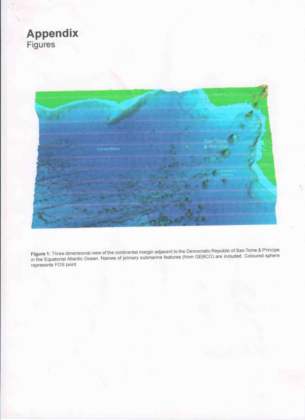
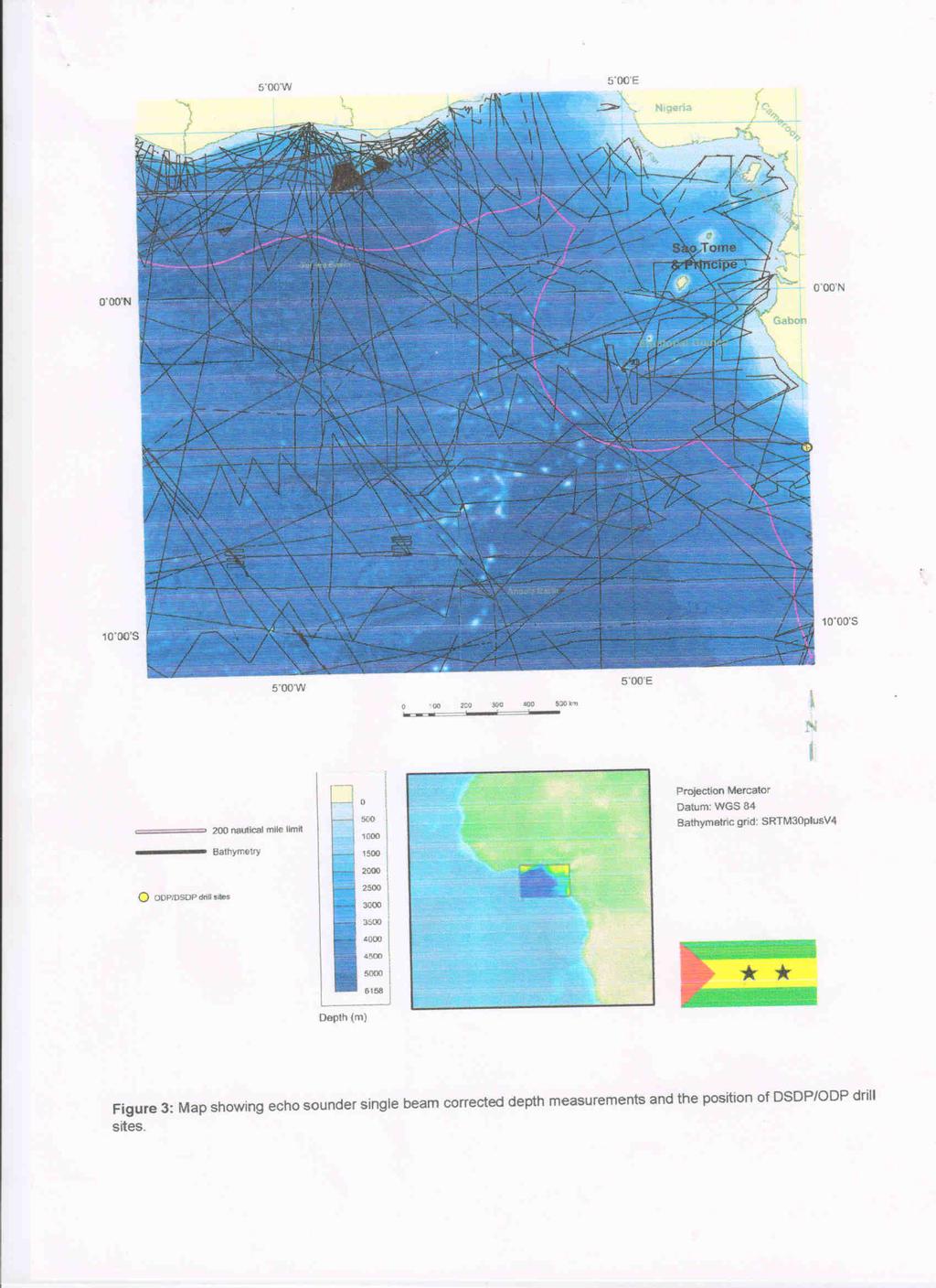
7 7 7. Preliminary information indicative of outer limits of the continental shelf beyond 200 M In accordance with SPLOS/183 op.p. 1 (a), this communication seeks to document that at least a single Foot of the Slope Point (FOS point) has a location that indicates that the Democratic Republic of São Tomé and Principe s continental shelf extends beyond 200 M from the normal baseline. Considering the limited scientific data available, no final conclusion is made regarding the most appropriate location of the base of the continental slope of the Democratic Republic of São Tomé and Principe at this stage. Rather it is found incumbent, based on available data, to document at least the minimum extent of the legal continental shelf by providing prima facie evidence that an FOS point may at least be located in a certain area, if not further offshore. While there may be grounds for carrying out additional surveys for the precise identification of FOS points (for which there is the possibility of significant variations), the following FOS point and the associated preliminary outer limit points are submitted as part of the preliminary information. These may be subject to later revision. 7.1 Existing database Figures 3 and 4 show track lines for bathymetric and analog seismic data that has been available for analyses to determine if the Democratic Republic of São Tomé and Principe meets the criteria for an extended continental shelf beyond 200 M (test of appurtenance). The majority of bathymetric and seismic data are sourced from the Geophysical Data System (Geodas) of the NOAA National Geophysical Data Center (NGDC) in Colorado. Additional bathymetric and seismic data are sourced from: L Institut français de recherche pour l'exploitation de la mer (IFREMER). The following satellite derived bathymetric grids have been used: SRTM30plus_V4. Total Sediment Thickness of the World's Oceans & Marginal Seas (provided by: World Data Center for Geophysics & Marine Geology, Boulder) was used as a first approximation for sediment thickness. All data are assembled, reformatted and provided by the One Stop Data Shop (GRID-Arendal, The analyses of the data were done in the Geocap software utilizing the UNCLOS Module ( Methods used are documented in the software documentation.
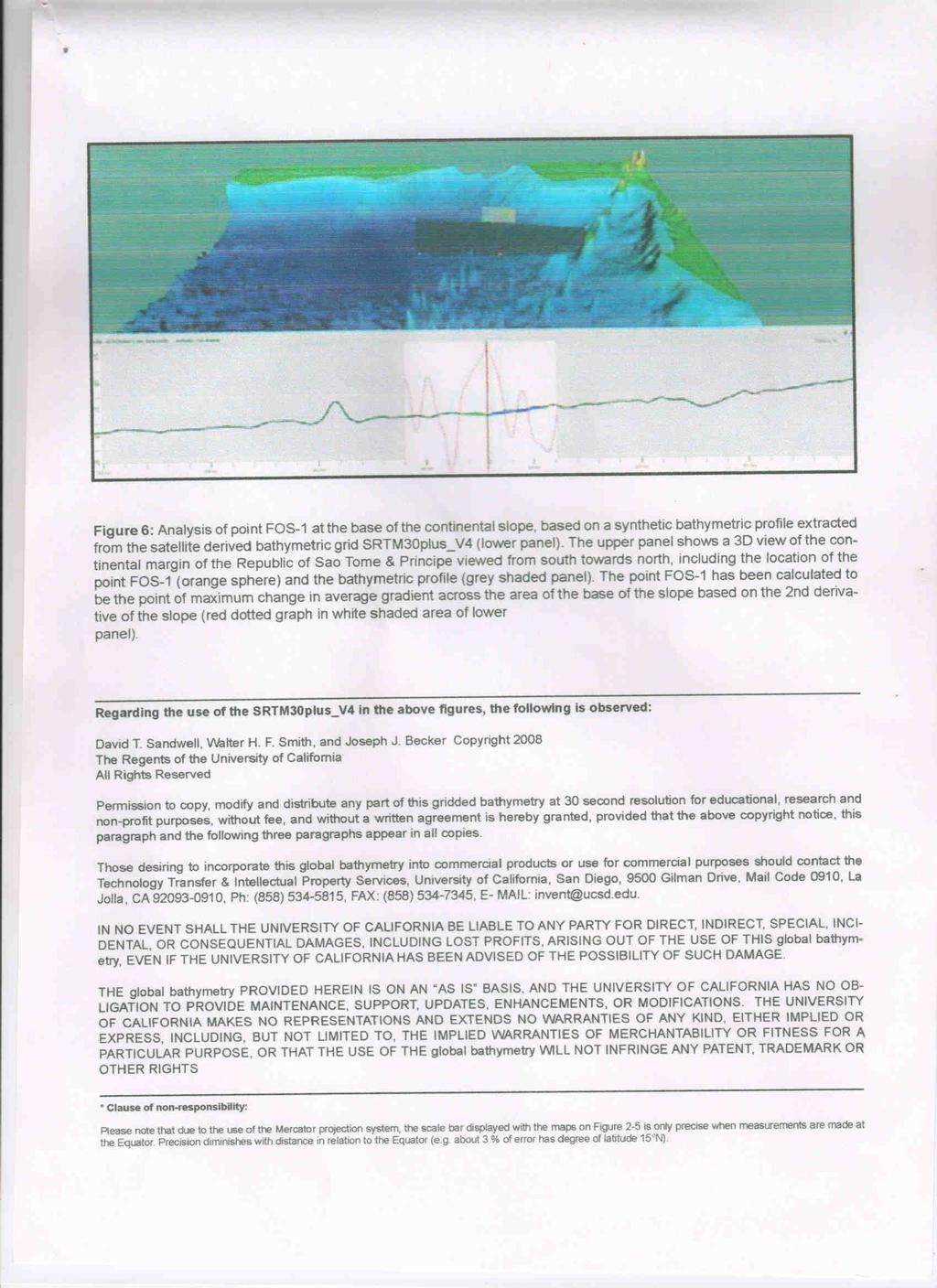
8 8 7.2 Foot of the continental slope points Several FOS points have been identified both on single-beam bathymetric profiles from the GEODAS and IFREMER databases and on bathymetric profiles extracted from the SRTM30plus_V4 grid. These FOS points are shown to generate continental shelf area beyond 200 M. One FOS point extracted from the SRTM30plus_V4 grid is plotted on figures 1 and 5 and is described in more detail in the following for documentation purposes and to demonstrate the variable nature of the continental margin off the coast of the Democratic Republic of São Tomé and Principe. This FOS point is indicative only and does not in any way represent the final representation of the foot of the continental slope in the vicinity of the Democratic Republic of São Tomé and Principe. The possibility of identifying FOS points located further seaward than the one documented here cannot be excluded, should more data be discovered or acquired and made available at a later stage FOS-1 Basic Data Data type Synthetic bathymetric profile extracted from bathymetric grid Data source SRTM30plus_V4 Point FOS-1 is located on the south-western flank of the Niger Fan west of the Democratic Republic of Sao Tome & Principe at the base of the continental slope. (Figures 1 and 2). The area of the base of the slope is identified on the basis of the morphology of the continental slope in the area as depicted by a synthetic bathymetric profile extracted from the satellite derived bathymetric grid SRTM30plus_V4 (Figure 6). Point FOS-1 was determined as the point of maximum change in gradient within the base of the slope area (Figure 6). 7.3 Indicative extent of continental shelf based on selected FOS points The FOS point generates continental shelf area beyond 200 M based on the sediment thickness criterion of article 76 paragraph 4(a)(i) and the 60 M distance criterion of article 76 paragraph 4(a)(ii). The exact location of the outer limits of the continental shelf beyond 200 M awaits the final analysis which will be submitted to the Commission (see section 8). However, the extent of the continental shelf beyond 200 M adjacent to the Democratic Republic of São Tomé and Principe is indicated in a general way in figure 5. Further studies and data are needed to clarify the final extend of the continental shelf beyond 200 M of the Democratic Republic of São Tomé and Principe.
9 9 8. Description of status of preparation and intended date of making a submission This communication takes advantage of available data from relevant intergovernmental bodies and organizations. The utilization of GRID-Arendal s global public marine geoscientific database, provides a careful documentation of the aforementioned FOS point thus providing prima facie evidence that the Democratic Republic of São Tomé and Principe s continental shelf extends beyond 200 M from the baseline. However, additional data collection may be necessary to provide exact information on the location of foot of the slope points. It should be pointed out that several conditions make it unfeasible or unpractical at this stage to engage into any attempts to acquire such data. The Scientific and Technical Guidelines (STG) of the Commission 3 gives guidance to the type and quality of the data that is required to support the submission of coastal State to the CLCS concerning the outer limit of its continental shelf. Chapter 9 of the STG specifies the format and recommended contents of such a submission. The STG, on the other hand, does not give any guidance to the planning and organisation of the project of preparing a submission. The Training Manual provided by Division for Ocean Affairs and the law of the Sea Office of Legal Affairs (DOALOS) 4, however, contains more details on how such a project may be conducted. According this Training Manual the following steps should be taken to plan and manage a submission: Undertake the initial appurtenance study; Produce a desktop study; Plan and acquire data; Analyse all data and produce all relevant scientific and technical documentation; Prepare the final submission; and Provide technical support to political level throughout the project cycle. The Preliminary information indicative of the outer limits of the continental shelf provided in this document shows that the Democratic Republic of São Tomé and Principe passes the test of appurtenance and the next step will be to prepare a desktop study. 3 Commission on the Limits of the Continental Shelf, Scientific and technical guidelines of the commission of the continental shelf. Division for Ocean Affairs and the Law of the Sea Office of Legal Affairs United Nations, document CLCS/11, 92 p. 4 Division for Ocean Affairs and the Law of the Sea, Office of Legal Affairs, Training Manual for delineation of the outer limits of the continental shelf beyond 200 nautical miles and for preparation of submissions to the Commission on the Limits of the Continental Shelf.
10 10 According to the Training Manual a desktop study shall cover the following items: Assemble and organize all pre-existing data; Analyse the data according to article 76; Identify areas of critical value for further studies; Subdivide the geographical area being considered according to the applicability of the formulae and constraints provisions; Identify the need for further data; and Determine preliminary survey plans, cost estimates and recommendations for future work. To fund activities related to preparing a submission, the Democratic Republic of São Tomé and Principe will make an application to the Trust fund for the purpose of facilitating the preparation of submissions to the Commission on the Limits of the Continental Shelf for developing States, in particular the least developed countries and small island developing States, and compliance with article 76 of the United Nations Convention on the Law of the Sea (UN Trust Fund) ( ). The UN Trust Fund does, however, not fund acquisition of data; consequently the desktop study should investigate ways to secure funding for acquisition of additional data if further studies show that this is necessary for the delineation of the Democratic Republic of São Tomé and Principe s extended continental shelf beyond 200 M. 9. Conclusion The data provided in the present submission of preliminary information indicative of the outer limits of the continental shelf beyond 200 nautical miles show that the Democratic Republic of São Tomé and Principe passes the test of appurtenance as described in the Scientific and Technical Guidelines of the Commission. The FOS point identified on the south-western flank of the Niger Fan west of the Democratic Republic of Sao Tomé and Principe at the base of the continental slope generates continental shelf area beyond 200 nautical miles based on the sediment thickness criterion of article 76, paragraph 4(a)(i) of the Convention and the 60 nautical miles criterion of article 76, paragraph 4(a)(ii) of the Convention.
11
12
13
14
15
16
PRELIMINARY INFORMATION
 PRELIMINARY INFORMATION INDICATIVE OF THE OUTER LIMITS OF THE CONTINENTAL SHELF AND DESCRIPTION OF THE STATUS OF PREPARATION OF MAKING A SUBMISSION TO THE COMMISSION ON THE LIMITS OF THE CONTINENTAL SHELF
EXECUTIVE SUMMARY A SUBMISSION OF DATA AND INFORMATION ON THE OUTER LIMITS OF THE CONTINENTAL SHELF OF THE REPUBLIC OF NIGERIA PURSUANT TO
 EXECUTIVE SUMMARY A SUBMISSION OF DATA AND INFORMATION ON THE OUTER LIMITS OF THE CONTINENTAL SHELF OF THE REPUBLIC OF NIGERIA PURSUANT TO PART VI OF AND ANNEX II TO THE UNITED NATIONS CONVENTION ON THE
MAPS AND COORDINATES...
 Table of Contents 1 INTRODUCTION... 2 2 MAPS AND COORDINATES... 3 3 ADVISORY ASSISTANCE FROM COMMISSION MEMBERS... 3 4 PROVISIONS OF ARTICLE 76 INVOKED... 3 5 OUTSTANDING MARITIME DELIMITATIONS... 4 6
JOINT SUBMISSION TO THE COMMISSION ON THE LIMITS OF THE CONTINENTAL SHELF BY TUVALU, THE REPUBLIC OF FRANCE AND NEW ZEALAND (TOKELAU)
") JOINT SUBMISSION TO THE COMMISSION ON THE LIMITS OF THE CONTINENTAL SHELF BY TUVALU, THE REPUBLIC OF FRANCE AND NEW ZEALAND (TOKELAU) TABLE OF CONTENTS i. PREFACE... iii ii. LIST OF FIGURES... iv iii.
JOINT SUBMISSION TO THE COMMISSION ON THE LIMITS OF THE CONTINENTAL SHELF BY TUVALU, THE REPUBLIC OF FRANCE AND NEW ZEALAND (TOKELAU) TABLE OF CONTENTS i. PREFACE... iii ii. LIST OF FIGURES... iv iii.
CONTINENTAL SHELF SUBMISSION OF ANGOLA - EXECUTIVE SUMMARY -
 CONTINENTAL SHELF SUBMISSION OF ANGOLA - EXECUTIVE SUMMARY - INDEX List of Figures 2 List of Tables 3 1 Introduction 5 2 Provisions of Article 76 7 3 Angolan Institutions responsible for the Submission
Preliminary Information Indicative of the Outer Limits of the Continental Shelf Beyond 200 Nautical Miles of the People s Republic of China
 (Translation) Preliminary Information Indicative of the Outer Limits of the Continental Shelf Beyond 200 Nautical Miles of the People s Republic of China 1. The People s Republic of China ratified the
EXECUTIVE SUMMARY A PARTIAL SUBMISSION OF DATA AND INFORMATION ON THE OUTER LIMITS OF THE CONTINENTAL SHELF OF THE KINGDOM OF TONGA PURSUANT TO
 EXECUTIVE SUMMARY A PARTIAL SUBMISSION OF DATA AND INFORMATION ON THE OUTER LIMITS OF THE CONTINENTAL SHELF OF THE KINGDOM OF TONGA PURSUANT TO PART VI OF AND ANNEX II TO THE UNITED NATIONS CONVENTION
IRELAND. PART I Executive Summary
 IRELAND Submission to the Commission on the Limits of the Continental Shelf pursuant to Article 76, paragraph 8 of the United Nations Convention on the Law of the Sea 1982 in respect of the area abutting
OUTER CONTINENTAL SHELF CLAIMS IN THE ARCTIC. Presentation given by Dr. Kamrul Hossain ASA University Bangladesh 15 March 2010
 OUTER CONTINENTAL SHELF CLAIMS IN THE ARCTIC Presentation given by Dr. Kamrul Hossain ASA University Bangladesh 15 March 2010 Contents Historical background of the continental shelf Concept of continental
The french national programme for claiming continental shelf beyond 200 Miles
 The french national programme for claiming continental shelf beyond 200 Miles Using global bathymetric models in the context of an Extended Continental Shelf submission EXTRAPLAC Using Global Bathymetric
CONFERENCE OF PARLIAMENTARIANS OF THE ARCTIC REGION. UN LOS Convention and the extended continental shelf in the Arctic
 CONFERENCE OF PARLIAMENTARIANS OF THE ARCTIC REGION UN LOS Convention and the extended continental shelf in the Arctic Presentation given by Dr. Kamrul Hossain Finnish Parliament 18 November 2009 Contents
Article 76, variations in annotation and implementation seen in submission documents for the claim of Extended Continental Shelf
 Article 76, variations in annotation and implementation seen in submission documents for the claim of Extended Continental Shelf Mr. Shin Tani Chairman, IHO/IAG Advisory Board on the Law of the Sea (ABLOS)
The Southern Continental Shelf of Greenland
 Partial Submission of the Government of the Kingdom of Denmark together with the Government of Greenland to the Commission on the Limits of the Continental Shelf The Southern Continental Shelf of Greenland
UNCLOS Article 76- Formulae and constraint lines
 UNCLOS Article 76- Formulae and constraint lines Dr Lindsay Parson (UNCLOS Group, National Oceanography Centre, UK) ABLOS TUTORIAL SESSION - Article 76 of UNCLOS 10th October 2005 IHO/IAG/IOC Advisory
1982 United Nations Convention on the Law of the Sea
 1982 United Nations Convention on the Law of the Sea Article 16, 47, 75, 76 and 84 Article 16, 47, 75, 76 and 84 require Coastal States to deposit geographic information pertaining to their maritime limits
The Continental Shelf North of the Faroe Islands
 Partial Submission of the Government of the Kingdom of Denmark together with the Government of the Faroes to the Commission on the Limits of the Continental Shelf The Continental Shelf North of the Faroe
FOOT OF THE CONTINENTAL SLOPE IN ARTICLE 76
 FOOT OF THE CONTINENTAL SLOPE IN ARTICLE 76 Vaughan Stagpoole, Institute of Geological & Nuclear Sciences, Lower Hutt, New Zealand, v.stagpoole@gns.cri.nz Ray Wood, Institute of Geological & Nuclear Sciences,
Marine Geospatial Software: Generating Economic Benefits from Hydrographic Data and Calculation of Maritime Boundaries
 Marine Geospatial Software: Generating Economic Benefits from Hydrographic Data and Calculation of Serge LEVESQUE and Alexis CARDENAS, Canada Key words: marine geospatial data, hydrography, economic benefits,
Regional Aspects of Maritime Boundary Delimitation in the Gulf of Guinea: current situation, challenges and possible solutions
 Regional Aspects of Maritime Boundary Delimitation in the Gulf of Guinea: current situation, challenges and possible solutions BY JUSTIN TANGA BIANG UNNIPPON ALUMNAE 20092010 INTRODUCTION (1) For the purpose
DELIMITATION OF THE MOZAMBIQUE MARITIME BOUNDARIES WITH NEIGHBORING STATES (INCLUDING THE EXTENDED CONTINENTAL SHELF) AND MANAGEMENT OF OCEAN ISSUES
 AND MANAGEMENT OF OCEAN ISSUES") DELIMITATION OF THE MOZAMBIQUE MARITIME BOUNDARIES WITH NEIGHBORING STATES (INCLUDING THE EXTENDED CONTINENTAL SHELF) AND MANAGEMENT OF OCEAN ISSUES Elisio B. Jamine United Nations The Nippon Fellowship
DELIMITATION OF THE MOZAMBIQUE MARITIME BOUNDARIES WITH NEIGHBORING STATES (INCLUDING THE EXTENDED CONTINENTAL SHELF) AND MANAGEMENT OF OCEAN ISSUES Elisio B. Jamine United Nations The Nippon Fellowship
Briefing document of the status of maritime boundaries in Pacific island countries
 Secretariat of the Pacific Community Seventh Heads of Fisheries Meeting (28 Feb. 4 March 2011, Noumea, New Caledonia) Working Paper 5 Original: English Briefing document of the status of maritime boundaries
Maritime delimitation and environmental protection of fragile seas
 Gemma Andreone Istituto di Studi Giuridici Internazionali - Consiglio Nazionale delle Ricerche Marsafenet Cost Action Chair - www.marsafenet.org Maritime delimitation and environmental protection of fragile
Pacific Islands Regional Maritime Boundaries Project
 Pacific Islands Regional Maritime Boundaries Project 31 st Star Conference, Nadi, FIJI 6-8 June 2016 Jens Kruger Head of Ocean & Coastal Geoscience Sector Andrick Lal Project Officer (Surveying) Emily
COMPLICATIONS IN DELIMITING THE OUTER CONTINENTAL SHELF. Ron Macnab Geological Survey of Canada (Retired)
") COMPLICATIONS IN DELIMITING THE OUTER CONTINENTAL SHELF Ron Macnab Geological Survey of Canada (Retired) DISCLAIMER The contents of this presentation are the author s personal views only, and do not represent
COMPLICATIONS IN DELIMITING THE OUTER CONTINENTAL SHELF Ron Macnab Geological Survey of Canada (Retired) DISCLAIMER The contents of this presentation are the author s personal views only, and do not represent
Linking Global and Regional Levels in the Management of Marine Areas Beyond National Jurisdiction
 Linking Global and Regional Levels in the Management of Marine Areas Beyond National Jurisdiction South Atlantic Region Session 4: «Experiences, Priorities and Opportunities in the South Atlantic and Indian
Ocean Governance and the Japanese Basic Act on Ocean Policy
 Ocean Governance and the Japanese Basic Act on Ocean Policy Hiroshi Terashima Executive Director Ocean Policy Research Foundation 14 April 2009 The United Nations Nippon Foundation Fellowship Programme
Legal Interpretation of Submarine Ridges & Submarine Elevations
 Legal Interpretation of Ridges & Article 76, paragraph 6 New Knowledge and Changing Circumstances in the Law of the Sea Reykjavik, Iceland June 28, 2018 Kevin Baumert U.S. Department of State U.S. ECS
HOW TO DEFINE THE BASE OF THE SLOPE IN LOW GRADIENT PASSIVE MARGINS? BRAZILIAN CONTINENTAL SHELF PROJECT (LEPLAC)
") HOW TO DEFINE THE 1 BASE OF THE SLOPE IN LOW GRADIENT PASSIVE MARGINS? BRAZILIAN CONTINENTAL SHELF PROJECT (LEPLAC) Izabel King Jeck Commander, DHN, Brazilian Navy izabel@dhn.mar.mil.br How to apply art.76
HOW TO DEFINE THE 1 BASE OF THE SLOPE IN LOW GRADIENT PASSIVE MARGINS? BRAZILIAN CONTINENTAL SHELF PROJECT (LEPLAC) Izabel King Jeck Commander, DHN, Brazilian Navy izabel@dhn.mar.mil.br How to apply art.76
Law of the Sea Symposium, February, 2016, TOKYO International Law for the Resources of the Sea
 Law of the Sea Symposium, 16-17 February, 2016, TOKYO International Law for the Resources of the Sea Segment 2 Governance of Resources of the Continental Shelf (including extended continental shelf) Introduction
Questions and Topics
 Plate Tectonics and Continental Drift Questions and Topics 1. What are the theories of Plate Tectonics and Continental Drift? 2. What is the evidence that Continents move? 3. What are the forces that
ITLOS s approach to the delimitation of the continental shelf beyond 200 M in Bangladesh/Myanmar: Theoretical and practical difficulties
 ITLOS s approach to the delimitation of the continental shelf beyond 200 M in Bangladesh/Myanmar: Theoretical and practical difficulties London International Boundary Conference 18-19 April 2013 Panel
This Book Belonged to
 THE AMERICAN UNIVERSITY Washington College of Law Library This Book Belonged to The Private Collection of Judge Richard R, Baxter I THE AMERICAN UNIVERSITY Washington College of Law Law Library W-, D.C.
Finding the continental shelf integration of geology and geophysics
 Finding the continental shelf integration of geology and geophysics R Wood Institute of Geological and Nuclear Sciences, PO Box 30-368, Lower Hutt, Telephone 64-4-570 4867, Fax 64-4-570 4803, Email r.wood@gns.cri.nz
Sam Bateman and. State Practice Regarding Straight Baselines In East Asia Legal, Technical and Political Issues in a
 State Practice Regarding Straight Baselines In East Asia Legal, Technical and Political Issues in a Changing Environment Sam Bateman and Clive Schofield The Australian National Centre for Ocean Resources
HAMILTON DECLARATION ON COLLABORATION FOR THE CONSERVATION OF THE SARGASSO SEA
 HAMILTON DECLARATION ON COLLABORATION FOR THE CONSERVATION OF THE SARGASSO SEA Hamilton, Bermuda 11 March, 2014 WE, THE SIGNATORIES LISTED BELOW: Recognising that the islands of Bermuda are the only land
Meandering Miocene Deep Sea Channel Systems Offshore Congo, West Africa
 Meandering Miocene Deep Sea Channel Systems Offshore Congo, West Africa S. Baer* (PGS), J. E. Comstock (PGS), K. Vrålstad (PGS), R. Borsato (PGS), M. Martin (PGS), J.P. Saba (SNPC), B. Débi-Obambé (SNPC)
Map shows 3 main features of ocean floor
 Map shows 3 main features of ocean floor 2017 Pearson Education, Inc. Chapter 3 Marine Provinces 2017 Pearson Education, Inc. 1 Chapter 3 Overview The study of bathymetry determines ocean depths and ocean
Oceanography, An Invitation to Marine Science 9e Tom Garrison. Ocean Basins Cengage Learning. All Rights Reserved.
 Oceanography, An Invitation to Marine Science 9e Tom Garrison 4 Ocean Basins Key Concepts Tectonic forces shape the seabed The ocean floor is divided into continental margins and deep ocean basins The
Clive Schofield * and David Freestone **
 Holding Back the Waves: Options to Secure Maritime Jurisdictional Claims in the Face of Sea Level Rise Clive Schofield * and David Freestone ** *Australian National Centre for Ocean Resources and Security
The Place of Joint Development in the Sustainable Arctic Governance
 The Place of Joint Development in the Sustainable Arctic Governance ShipArc2015: Joint WMU - IMO - Arctic Council International Conference on Safe and Sustainable Shipping in a Changing Arctic Environment
Kilometre-Scale Uplift of the Early Cretaceous Rift Section, Camamu Basin, Offshore North-East Brazil*
 Kilometre-Scale Uplift of the Early Cretaceous Rift Section, Camamu Basin, Offshore North-East Brazil* Iain Scotchman 1 and Dario Chiossi 2 Search and Discovery Article #50183 (2009) Posted May 20, 2009
Does Ascension Island have an outer continental shelf?
 Does Ascension Island have an outer continental shelf? Robin Cleverly UK Hydrographic Office Lindsay Parson NOC, Southampton (with Alan Evans, Peter Hunter, Rosemary Edwards of NOC and Chris Carleton of
Tore Henriksen a & Geir Ulfstein b a Faculty of Law, University of Tromsø, Tromsø, Norway. Available online: 18 Feb 2011
 This article was downloaded by: [Bibliotheek van het Vredespaleis] On: 03 May 2012, At: 03:44 Publisher: Taylor & Francis Informa Ltd Registered in England and Wales Registered Number: 1072954 Registered
Part I. Executive Summary
 Part I. Executive Summary Partial Submission of Data and Information on the Limits of the Continental Shelf of Spain to the West of the Canary Islands, pursuant to Part VI and Annex II of United Nations
MARINE GEOLOGY & GEOGRAPHY
 MARINE GEOLOGY MARINE GEOLOGY & GEOGRAPHY Marine Geology 4 LAYERS OF THE EARTH CRUST THICKNESS: VARIES BETWEEN OCEAN & CONTINENTS 5-40 KM STATE: SOLID ELEMENTS: SILICON, ALUMINUM, CALCIUM, SODIUM, POTASSIUM
7B.4 ASSESSMENT OF THE GROSS U.S. OFFSHORE WIND ENERGY POTENTIAL
 7B.4 ASSESSMENT OF THE GROSS U.S. OFFSHORE WIND ENERGY POTENTIAL Marc Schwartz, Donna Heimiller, Steve Haymes, and Walt Musial National Renewable Energy Laboratory, Golden, Colorado 1. INTRODUCTION Offshore
Ocean Basins, Bathymetry and Sea Levels
 Ocean Basins, Bathymetry and Sea Levels Chapter 4 Please read chapter 5: sediments for next class and start chapter 6 on seawater for Thursday Basic concepts in Chapter 4 Bathymetry the measurement of
USU 1360 TECTONICS / PROCESSES
 USU 1360 TECTONICS / PROCESSES Observe the world map and each enlargement Pacific Northwest Tibet South America Japan 03.00.a1 South Atlantic Arabian Peninsula Observe features near the Pacific Northwest
xxv PART I THE DIVIDED OCEANS: INTERNATIONAL LAW GOVERNING JURISDICTIONAL ZONES 1
 Contents Preface page xv List of Figures xvii List of Tables xviii List of Abbreviations xix Table of Cases xxi Table of Treaties and Instruments xxv PART I THE DIVIDED OCEANS: INTERNATIONAL LAW GOVERNING
14.2 Ocean Floor Features Mapping the Ocean Floor
 14.2 Ocean Floor Features Mapping the Ocean Floor The ocean floor regions are the continental margins, the ocean basin floor, and the mid-ocean ridge. 14.2 Ocean Floor Features Continental Margins A continental
Some Thoughts on Maritime Delimitation among the Northeast Asian States
 Some Thoughts on Maritime Delimitation among the Northeast Asian States Seokwoo LEE Assistant Professor College of Law INHA University Korea leeseokwoo@inha.ac.kr 1 I. Common geographical features II.
GIS, Charts and UNCLOS Can they live together?
 GIS, Charts and UNCLOS Can they live together? Bill Hirst 1 and David Robertson 2 Address 1 Geoscience Australia GPO Box 378 Canberra, ACT 2601 Phone: 02 6249 9741 Fax: 02 6249 9939 Email: Bill.Hirst@ga.gov.au
Chapter 02 The Sea Floor
 Chapter 02 The Sea Floor Multiple Choice Questions 1. One of the following is not one of the world's major ocean basins: A. Atlantic Ocean B. Arctic Ocean C. Indian Ocean D. Antarctic Ocean E. Pacific
Chapter Overview. Bathymetry. Measuring Bathymetry. Measuring Bathymetry
 CHAPTER 3 Marine Provinces Chapter Overview The study of bathymetry determines ocean depths and ocean floor topography. Echo sounding and satellites are efficient bathymetric tools. Most ocean floor features
Lecture Marine Provinces
 Lecture Marine Provinces Measuring bathymetry Ocean depths and topography of ocean floor Sounding Rope/wire with heavy weight Known as lead lining Echo sounding Reflection of sound signals 1925 German
Bathymetry Measures the vertical distance from the ocean surface to mountains, valleys, plains, and other sea floor features
 1 2 3 4 5 6 7 8 9 10 11 CHAPTER 3 Marine Provinces Chapter Overview The study of bathymetry determines ocean depths and ocean floor topography. Echo sounding and satellites are efficient bathymetric tools.
APPENDIX 1 Figures 1-7
 APPENDIX 1 Figures 1-7 Figure 1: Three dimensional view of the continental margin adjacent to the Republic of in the eastern central Atlantic Ocean. Names of primary submarine features (from GEBCO) are
Outer Continental Shelf
 The Delimitation of the Outer Continental Shelf Presentation by Stephen Fietta Monaco, 17 October 2008 Latham & Watkins is the business name of Latham & Watkins (London) LLP, a registered limited liability
A comparison of structural styles and prospectivity along the Atlantic margin from Senegal to Benin. Peter Conn*, Ian Deighton* & Dario Chisari*
 A comparison of structural styles and prospectivity along the Atlantic margin from Senegal to Benin Overview Peter Conn*, Ian Deighton* & Dario Chisari* * TGS, Millbank House, Surbiton, UK, KT6 6AP The
The Continental Shelf Project: An overview of research activities in the Arctic Ocean on behalf of the Kingdom of Denmark
 The Continental Shelf Project: An overview of research activities in the Arctic Ocean on behalf of the Kingdom of Denmark Geological Survey of Denmark and Greenland Ministry of Climate and Energy John
MUHAMMAD S TAMANNAI, DOUGLAS WINSTONE, IAN DEIGHTON & PETER CONN, TGS Nopec Geological Products and Services, London, United Kingdom
 Geological and Geophysical Evaluation of Offshore Morondava Frontier Basin based on Satellite Gravity, Well and regional 2D Seismic Data Interpretation MUHAMMAD S TAMANNAI, DOUGLAS WINSTONE, IAN DEIGHTON
MARINE GEOLOGY & GEOGRAPHY
 MARINE GEOLOGY & GEOGRAPHY Bathymetry BATHYMETRY BATHYMETRY THE UNDERWATER EQUIVALENT TO TOPOGRAPHY THE STUDY OF WATER DEPTH A BATHYMETRIC MAP SHOWS FLOOR RELIEF OR TERRAIN AS CONTOUR LINES Bathymetry
SOLVING THE RIDGES ENIGMA OF ARTICLE 76 OF THE UNITED NATIONS CONVENTION ON THE LAW OF THE SEA. Written by: George Taft Presented by: George Taft
 SOLVING THE RIDGES ENIGMA OF ARTICLE 76 OF THE UNITED NATIONS CONVENTION ON THE LAW OF THE SEA Written by: George Taft Presented by: George Taft (The views contained herein are those of the author and
Plate Tectonics. entirely rock both and rock
 Plate Tectonics I. Tectonics A. Tectonic Forces are forces generated from within Earth causing rock to become. B. 1. The study of the origin and arrangement of Earth surface including mountain belts, continents,
The Sea Floor. Chapter 2
 The Sea Floor Chapter 2 Geography of the Ocean Basins World ocean is the predominant feature on the Earth in total area Northern Hemisphere = 61% of the total area is ocean. Southern Hemisphere = about
12/3/2014. Plate Tectonics: A Scientific Revolution Unfolds Earth Science, 13e Chapter 7. Continental drift: an idea before its time
 Plate Tectonics: A Scientific Revolution Unfolds Earth Science, 13e Chapter 7 Stanley C. Hatfield Southwestern Illinois College Continental drift: an idea before its time Alfred Wegener First proposed
file:///c:/documents and Settings/kapilan/My Documents/WEB Domest...
 1 of 5 3/17/2011 1:15 PM Print Close Maritime Zones Law A LAW TO PROVIDE FOR THE DECLARATION OF THE TERRITORIAL SEA AND OTHER MARITIME ZONES OF SRI LANKA, AND ALL OTHER MATTERS CONNECTED THEREWITH OR INCIDENTAL
The Agreement Concerning the Boundary Line Dividing Parts of the Continental Shelf Between Iran and the United Arab Emirates states that:
 2 The Imperial Government of Iran and the Government of the State of the United Arab Emirates (Dubai) signed an agreement on August 31, 1974, regarding the delimitation of their continental shelf boundary.
FEDERAL AUTHORITIES RESPONSIBLE FOR THE PREPARATION: Ministry of Foreign Affairs of the Russian Federation
 FEDERAL AUTHORITIES RESPONSIBLE FOR THE PREPARATION: Ministry of Natural Resources and Environment of the Russian Federation Federal Agency on Mineral Resources Ministry of Natural Resources and Environment
Orphan Basin, Offshore Newfoundland: New seismic data and hydrocarbon plays for a dormant Frontier Basin
 Orphan Basin, Offshore Newfoundland: New seismic data and hydrocarbon plays for a dormant Frontier Basin Jerry Smee* G&G Exploration Consulting, 301 400-3rd Avenue SW, Calgary, AB, T2P 4H2 Sam Nader, Paul
BRAZILIAN SOUTHERN MARGIN: AN EXAMPLE OF THE IDENTIFICATION OF THE BASE OF THE SLOPE ON A PASSIVE CONTINENTAL MARGIN
 BRAZILIAN SOUTHERN MARGIN: AN EXAMPLE OF THE IDENTIFICATION OF THE BASE OF THE SLOPE ON A PASSIVE CONTINENTAL MARGIN Luiz Carlos Torres Brazilian Navy Hydrographic Center Izabel King Jeck Brazilian Navy
Lab 1: Plate Tectonics April 2, 2009
 Name: Lab 1: Plate Tectonics April 2, 2009 Objective: Students will be introduced to the theory of plate tectonics and different styles of plate margins and interactions. Introduction The planet can be
Limits in the Seas. No. 96 June 6, Greece Italy. Continental Shelf Boundary. (Country Codes: GR-IT)
") Limits in the Seas No. 96 June 6, 1982 Greece Italy Continental Shelf Boundary (Country Codes: GR-IT) The Geographer Office of the Geographer Bureau of Intelligence and Research INTERNATIONAL BOUNDARY
Limits in the Seas No. 96 June 6, 1982 Greece Italy Continental Shelf Boundary (Country Codes: GR-IT) The Geographer Office of the Geographer Bureau of Intelligence and Research INTERNATIONAL BOUNDARY
1. Name at least one place that the mid-atlantic Ridge is exposed above sea level.
 Interpreting Tectonic and Bathymetric Maps. The purpose of this lab is to provide experience interpreting the bathymetry of the seafloor in terms of tectonic and geologic settings and processes. Use the
IMA s ROLE IN COASTAL AND OCEAN GOVERNANCE IN TRINIDAD AND TOBAGO
 IMA s ROLE IN COASTAL AND OCEAN GOVERNANCE IN TRINIDAD AND TOBAGO Presented by Rahanna Juman, Deputy Director (Ag.) About the Institute of Marine Affairs Institute of Marine Affairs (IMA) was established,
ARTICLE 76: THE RIDGE ISSUE
 ARTICLE 76: THE RIDGE ISSUE by Alan EVANS 1, Chris CARLETON 2 and Lindsay PARSON 1 Address 1; Address 2; Southampton Oceanography Centre United Kingdom Hydrographic Office European Way Admiralty Way Southampton
MAR110 LECTURE #6 West Coast Earthquakes & Hot Spots
 17 September 2007 Lecture 6 West Coast Earthquakes & Hot Spots 1 MAR110 LECTURE #6 West Coast Earthquakes & Hot Spots Figure 6.1 Plate Formation & Subduction Destruction The formation of the ocean crust
GeomaticsWorld. Issue No 3 : Volume 21. Helping to unravel Easter Island s mysterious statues. DGI 2013: maritime security highlighted
 GeomaticsWorld MARCH APRIL 2013 Issue No 3 : Volume 21 BIM: repeat the message even if you lose the will to live Helping to unravel Easter Island s mysterious statues DGI 2013: maritime security highlighted
The Structure of the Earth and Plate Tectonics
 The Structure of the Earth and Plate Tectonics Structure of the Earth The Earth is made up of 4 main layers: Inner Core Outer Core Mantle Crust Crust Mantle Outer core Inner core The Crust This is where
Continental Margin Geology of Korea : Review and constraints on the opening of the East Sea (Japan Sea)
") Continental Margin Geology of Korea : Review and constraints on the opening of the East Sea (Japan Sea) Han-Joon Kim Marine Satellite & Observation Tech. Korea Ocean Research and Development Institute
Continental Margin Geology of Korea : Review and constraints on the opening of the East Sea (Japan Sea) Han-Joon Kim Marine Satellite & Observation Tech. Korea Ocean Research and Development Institute
A) B) C) D) 4. Which diagram below best represents the pattern of magnetic orientation in the seafloor on the west (left) side of the ocean ridge?
 B) C) D) 4. Which diagram below best represents the pattern of magnetic orientation in the seafloor on the west (left) side of the ocean ridge?") 1. Crustal formation, which may cause the widening of an ocean, is most likely occurring at the boundary between the A) African Plate and the Eurasian Plate B) Pacific Plate and the Philippine Plate C)
1. Crustal formation, which may cause the widening of an ocean, is most likely occurring at the boundary between the A) African Plate and the Eurasian Plate B) Pacific Plate and the Philippine Plate C)
1. I can describe evidence for continental drift theory (e.g., fossil evidence, mountain belts, paleoglaciation)
") Science 10 Review Earth Science Vocabulary asthenosphere continental drift theory converging plates diverging plates earthquakes epicentre fault hot spot inner core lithosphere mantle mantle convection
Science 10 Review Earth Science Vocabulary asthenosphere continental drift theory converging plates diverging plates earthquakes epicentre fault hot spot inner core lithosphere mantle mantle convection
I. LIBYA I.1. COUNTRY CHARACTERISTICS. Country reports
 Country reports I. LIBYA Disclaimer This document has not been adopted by the European Commission and should therefore not be relied upon as a statement of the European Commission. The purpose of this
Chapter Two. Figure 02_02. Geography of the Ocean Basins. The Sea Floor
 Chapter Two The Sea Floor Geography of the Ocean Basins Figure 02_02 The world ocean is the predominant feature on the Earth in total area. In the Northern Hemisphere, 61% of the total area is ocean. In
Australia Government Geospatial Capacity Building Efforts in Asia and the Pacific. Dr John Dawson
 Australia Government Geospatial Capacity Building Efforts in Asia and the Pacific Dr John Dawson Presentation Overview About Geoscience Australia Examples of Geospatial Capacity Building Activity Geodesy
Pacific Islands Regional Maritime Boundaries Project the latest Update. Malakai Vakautawale (Mr) Maritime Boundaries Adviser
 Maritime Boundaries Adviser") Pacific Islands Regional Maritime Boundaries Project the latest Update Malakai Vakautawale (Mr) Maritime Boundaries Adviser Consortium Partners 2 What we do? Provide technical advice and support on MB
Pacific Islands Regional Maritime Boundaries Project the latest Update Malakai Vakautawale (Mr) Maritime Boundaries Adviser Consortium Partners 2 What we do? Provide technical advice and support on MB
Draft Presentation Carleton Conference on the Arctic Is There a Need for New Legal Regime in the Arctic?
 Draft Presentation Carleton Conference on the Arctic Is There a Need for New Legal Regime in the Arctic? Donald McRae, University of Ottawa The climatic changes affecting the Arctic have lead to visions
How to Deal with Maritime Boundary Uncertainty in Oil and Gas Exploration and Production Areas*
 The University of Texas School of Law Presented: International Upstream Energy Transactions January 17-18, 2013 Houston, TX How to Deal with Maritime Boundary Uncertainty in Oil and Gas Exploration and
The Automated Delimitation of Maritime Boundaries - An Australian Perspective
 The Automated Delimitation of Maritime Boundaries - An Australian Perspective P.A. Collier, B.A. Murphy, D.J. Mitchell and F.J. Leahy, Department of Geomatics, The University of Melbourne, Australia Determining
Fig Available seismic reflection, refraction, and magnetic profiles from 107 the Offshore Indus Basin close to the representative profile GCDH,
 List of Figures Page No. Fig. 1.1 Generalized physiography of the Indian Ocean along with 2 selected (200 m, 1000 m, 2000 m, and 3000 m) bathymetric contours. Fig. 1.2 Lithospheric plates in the Indian
Figure 1: Location and bathymetry of the study area. Gulf of Guinea. Cameroon. Congo. Gabon. PGS/DGH Gabon MegaSurvey Coverage (35000Km 2 ) Eq.
 Eq.") Deepwater hydrocarbon prospectivity analysis of offshore North and South Gabon Muhammad S Tamannai (*), Thomas Hansen (1), Ron Borsato (1), Jennifer Greenhalgh (1) Martial-Rufin Moussavou (2) & Landry
Deepwater hydrocarbon prospectivity analysis of offshore North and South Gabon Muhammad S Tamannai (*), Thomas Hansen (1), Ron Borsato (1), Jennifer Greenhalgh (1) Martial-Rufin Moussavou (2) & Landry
Plate Tectonics. 1)The plate tectonic system 2)A theory is born 3) Early evidence for continental drift 4) Continental drift and paleomagnetism
The plate tectonic system 2)A theory is born 3) Early evidence for continental drift 4) Continental drift and paleomagnetism") Plate Tectonics Plate boundaries 1)The plate tectonic system 2)A theory is born 3) Early evidence for continental drift 4) Continental drift and paleomagnetism 6)History and future of plate motions system
Plate Tectonics Plate boundaries 1)The plate tectonic system 2)A theory is born 3) Early evidence for continental drift 4) Continental drift and paleomagnetism 6)History and future of plate motions system
Plate Tectonics: A Scientific Revolution Unfolds
 Chapter 2 Lecture Earth: An Introduction to Physical Geology Eleventh Edition Plate Tectonics: A Scientific Revolution Unfolds Tarbuck and Lutgens From Continental Drift to Plate Tectonics Prior to the
UNIT 3 GEOLOGY VOCABULARY FLASHCARDS THESE KEY VOCABULARY WORDS AND PHRASES APPEAR ON THE UNIT 3 CBA
 UNIT 3 GEOLOGY VOCABULARY FLASHCARDS THESE KEY VOCABULARY WORDS AND PHRASES APPEAR ON THE UNIT 3 CBA A map that shows Earth s Topographic Map surface topography, which is Earth s shape and features Contour
Selection of Algorithms to Determine Foot of the Continental Slope to Delineate the Extended of the Continental Shelf
 Selection of Algorithms to Determine Foot of the Continental Slope to Delineate the Extended of the Continental Shelf Nawi ABDULLAH, Malaysia Key words: Geoinformation/GI; Hydrography; Legislation; Extended
Faatasi Malologa (PGSC Chair) Director Department of Lands & Survey, Tuvalu
 Director Department of Lands & Survey, Tuvalu") Seventh Session of the United Nations Committee of Experts on Global Geospatial Information Management (UN-GGIM) - 31 July -4 August 2017 Faatasi Malologa (PGSC Chair) Director Department of Lands & Survey,
Seventh Session of the United Nations Committee of Experts on Global Geospatial Information Management (UN-GGIM) - 31 July -4 August 2017 Faatasi Malologa (PGSC Chair) Director Department of Lands & Survey,
NATIONAL REPORT TO THE 6 TH SOUTHERN AFRICAN AND ISLANDS HYDROGRAPHIC COMMISSION MEETING TO BE HELD IN PREPARED BY B. N. OWIN0
 REPUBLIC OF KENYA NATIONAL REPORT TO THE 6 TH SOUTHERN AFRICAN AND ISLANDS HYDROGRAPHIC COMMISSION MEETING TO BE HELD IN MANGOCHI, MALAWI, 27th 28 th AUGUST, 2007. PREPARED BY B. N. OWIN0 SENIOR ASSISTANT
TH P5 07 INSIGHTS INTO THE TECTONIC EVOLUTION AND PROSPECTIVITY OF MADAGASCAR OFFSHORE BASINSN
 Technical paper TH P5 07 INSIGHTS INTO THE TECTONIC EVOLUTION AND PROSPECTIVITY OF MADAGASCAR OFFSHORE BASINSN Authors R. Dirkx* (TGS), F. Winter (TGS), S. Musa (TGS), R. Cooke (TGS), B. Sayers (TGS),
Movement of the Earth s Crust: Formation of: Mountain s Plateau's and Dome s
 Movement of the Earth s Crust: Formation of: Mountain s Plateau's and Dome s References Information taken from several places including Prentice Hall Earth Science: @ http://www.eram.k12.ny.us/education/components/docmgr/default.php?sectiondetaili
Seabed knowledge In support of UN SDGs
 Seabed knowledge In support of UN SDGs Evert Flier Fiskerifaglig forum 2. november 2017 Hydrography & small scale fishing Hydrography in Transition Serving the Maritime Community Hydrography in Transition