Part I. Executive Summary
|
|
|
- Anis Lloyd
- 6 years ago
- Views:
Transcription


1 Part I. Executive Summary Partial Submission of Data and Information on the Limits of the Continental Shelf of Spain to the West of the Canary Islands, pursuant to Part VI and Annex II of United Nations Convention on the Law of the Sea 2014 Submission to the Commission on the Limits of the Continental Shelf through the Secretary General of the Organization of the United Nations English Traslation of the Original Text in Spanish
2 Part I. Executive Summary Partial Submission of Data and Information on the Limits of the Continental Shelf of Spain to the West of the Canary Islands, pursuant to Part VI and Annex II of United Nations Convention on the Law of the Sea R/V Hespérides View of the volcanic cliffs La Palma island R/V Miguel Oliver Submarine volcano of the El Hierro island Oceanographic cruise GAIRE_2011 Image of Atlas PARASOUND of the submarine eruption in El Hierro e Image of TOPAS echosounder of submarine debris flows 3-D bathymetric image of the Echo seamount Multibeam image of the Garoe mount R/V Sarmiento de Gamboa 3-D Perspective of the Canary Islands from the west showing giant debris flow sliding on the slope 2014 Submission to the Commission on the Limits of the Continental Shelf through the Secretary General of the Organization of the United Nations English Traslation of the Original Text in Spanish
3 Continental Shelf of Spain in the area to the West of the Canary Islands 1 TABLE OF CONTENTS 1. Introduction Outer limits of the continental shelf beyond 200 nautical miles in the area to the West of the Canary Islands Specific provisions of Article 76 invoked in support of the present Submission Names of Commission members who provided advice during the preparation of the Submission Absence of disputes State bodies responsible for the preparation of the partial Submission on the continental shelf Detailed description of the outer limits of the continental shelf beyond 200 nautical miles in the area to the West of the Canary Islands.. 13 Pág. ANNEXES Annex 1. List of coordinates of the fixed points that define the outer limits of the continental shelf of Spain in the area to the West of the Canary Islands.. 18
4 2 Executive Summary 2 FIGURES Pág. Figure 1: 3 D view of the Canary Islands (GEBCO 2003 global bathymetry) 7 Figure 2: Layout of the oceanographic surveys carried out to the West of the Canary Islands, Figure 3: Overview of the outer limits of the continental shelf of Spain beyond 200 nautical miles in the area to the West of the Canary Islands Figure 4: Detail of the outer limits in the northern zone of the continental shelf of Spain beyond 200 nautical miles in the area to the West of the Canary Islands 16 Figure 5: Detail of the outer limits in the southern zone of the continental shelf of Spain beyond 200 nautical miles in the area to the West of the Canary Islands 17 TABLES Table 1.1: Methods and lenght of the lines acquired in the oceanographic surveys carried out to obtain data for this Submission Table 1.2: List of experts who have prepared this Submission, with their respective technical and scientific field of specialty. 6 12
 to the Commission on the Limits of the Continental Shelf (hereinafter the Commission ) has been made pursuant to")
5 Continental Shelf of Spain in the area to the West of the Canary Islands 3 1. Introduction 1 1 This Submission from the Kingdom of Spain (hereinafter Spain ) to the Commission on the Limits of the Continental Shelf (hereinafter the Commission ) has been made pursuant to article 76 and Annex II of the 1982 United Nations Convention on the Law of the Sea (hereinafter "the Convention"), in order to establish the outer limits of the continental shelf beyond 200 nautical miles (M) in the area to the West of the Canary Islands. This Submission is, therefore, of a partial nature, in accordance with Annex I, paragraph 3, of the Rules of Procedure of the Commission (CLCS/40/Rev.1). Oceanographic vessel Hespérides 1 2 Spain presented in May 2009 the Preliminary Submission and Description of the State of Preparation, pursuant to decision SPLOS/183, of the outer limits of the Continental Shelf of Spain in the area to the West de the Canary Islands, submitted herewith. The Preliminary Submission is publicly available on the Commission's website: preliminaryinfo.pdf 1 3 With this document, Spain complied with the provisions of paragraph 1(a) of SPLOS/183, regarding the decisions adopted at the Eighteenth Meeting of States Parties to the Convention, presenting: a) Preliminary information on the outer limits beyond 200 M of the continental shelf of Spain in the area to the West of the Canary Islands, b) A description of the state of preparation of aforesaid Partial Submission, and
 The partial joint")
6 4 Executive Summary 4 c) An indication of the planned date of registering the Submission. 1 4 Spain presented to the Commission two more Partial Submissions on the delineation of the outer limits of its continental shelf pursuant to Article 76 of the Convention: a) The partial joint Submission by France, Ireland, United Kingdom of Great Britain and Northern Ireland and Spain (FISU) in the area of the Celtic Sea and the Bay of Biscay was deposited on 19 May 2006 at the offices of the Division for Ocean Affairs and the Law of the Sea (DOALOS), and formally presented to the Commission at the eighteenth session (CLCS/52). The final Recommendations were approved by the Commission on 24 March 2009 (CLCS/62); b) The partial Submission in respect of the area of Galicia was registered at DOALOS on 11 May of 2009 and presented to the Commission on 7 April 2010 during the twentyfifth session (CLCS/66). Oceanographic vessel Sarmiento de Gamboa Islands. 1 5 In accordance with the procedures described in article 76, paragraph 8, and article 4 of Annex II of the Convention, and in the Commission's Rules of Procedure (CLCS/40/Rev. 1), Spain has prepared this Submission with scientific and technical data that support the definition of the outer limit of the continental shelf beyond 200 M in the area to the West of the Canary 1 6 This Submission has been prepared using multibeam echosounder data, as well as parametric echosounder profiles, multichannel seismic data, dredges and core samples (Table 1.1.) obtained over six oceanographic surveys carried out between 2010 and 2014 (oceanographic surveys GAROE 2010, DRAGO 2011, GAIRE 2011, ZEEE 2011, AMULEY ZEEE 2012 and MAEC SUBVENT ) on board the Spanish research vessels (R/V) Hespérides, Sarmiento de Gamboa and Miguel Oliver. These oceanographic
, Spanish Institute of Oceanography (Instituto Español de Oceanografía, IEO) and")
 of the Research Programme of the Spanish")
7 Continental Shelf of Spain in the area to the West of the Canary Islands 5 surveys were specifically designed and carried out by the Technical Group for the Extension of the Spanish Continental Shelf, composed by experts of the Geological Survey of Spain (Instituto Geológico y Minero de España, IGME), Spanish Institute of Oceanography (Instituto Español de Oceanografía, IEO) and Hydrographic Institute of the Navy (Instituto Hidrográfico de la Marina, IHM), coordinated by Dr. Luis Somoza Losada. 1 7 Compilation of multibeam bathymetry also included data collected in four previous hydrographic surveys (ZEEE 99, ZEEE 00, ZEEE 2011 and ZEEE 2012) of the Research Programme of the Spanish Exclusive Economic Zone (ZEEE), carried out on board the R/V Oceanographic vessel Miguel Oliver Hespérides and coordinated by the General Directorate on Infrastructures of the Spanish Ministry of Defence (Fig. 1). 1 8 A total of 68,338 km of bathymetric survey lines were carried out using different types of multibeam echosounders (Simrad EM 12, EM 120 and EM 302, Atlas HYDROSWEEP DS) and high resolution parametric echosounders (TOPAS PS 18 and Atlas PARASOUND P 35) (Table 1.1). In addition, a total of 4,471 km of multichannel seismic reflection profiles were acquired using a digital streamer of 3,500 m in length, 280 channels and hydrophones distributed every 12.5 m (Table 1.1.) aboard the R/V Sarmiento de Gamboa. 3 D image of parametric echosounder and multibeam bathymetry obtained during the eruption of the submarine volcano at El Hierro Island 1 9 Moreover, this Submission had the support of three multichannel seismic profiles carried out during the CANARIAS_1988 survey, which were also used in drafting the report "Preliminary Information and Description of the State of Preparation, pursuant to
8 6 Executive Summary 6 decision SPLOS/183, on the Partial Submission regarding the Outer Limits of the Continental Shelf of Spain in the Area to the West of the Canary Islands". Table 1.1: Methods and length of the lines acquired in the oceanographic surveys carried out to obtain data for this Submission. Oceanographic survey name Year Research vessel (R/V) Type of multibeam /parametric echosounders Length of lines (km) Samples (type) Seismic reflection (km) CANARIAS_ Geco Tau 1,950 1,950 ZEEE_1999 ZEEE_ Hespérides GAROE_ Hespérides DRAGO_ GAIRE_ Miguel Oliver Sarmiento de Gamboa ZEEE_ Hespérides AMULEY_ ZEE_2012 MAEC_SUBVENT 1_ Hespérides 2013 Hespérides Simrad EM 12 TOPAS PS 18 Simrad EM 120 TOPAS PS 18 Simrad EM 302 TOPAS PS 18 Atlas HYDROSWEEP DS Atlas PARASOUND P 35 Simrad EM 120 TOPAS PS 18 Simrad EM 120 TOPAS PS 18 Simrad EM 120 TOPAS PS 18 4,014 12,449 10,895 Rock dredges 4,471 4,471 13,235 18,054 7,284 Gravity cores/ rock dredges TOTAL (km) 72,352 6,210


9 Continental Shelf of Spain in the area to the West of the Canary Islands 7 Figure 1: 3 D view of the Canary Islands (global bathymetry taken from GEBCO GDA, 2003).


10 8 Executive Summary 8 Figure 2: Layout of the oceanographic surveys carried out to the West of the Canary Islands,

11 Continental Shelf of Spain in the area to the West of the Canary Islands 9 2. Outer limits of the continental shelf beyond 200 M in the area to the West of the Canary Islands 2 1 This partial Submission refers solely to the outer limits of the continental shelf in the area to the West of the Canary Islands (Figs. 1 and 2). 2 2 In accordance with the Scientific and Technical Guidelines of the Commission (CLCS/11), this Submission demonstrates that the submerged prolongation of the land mass extends beyond the 200 M in the area to the West of the Canary Islands, and thus the test of appurtenance is fulfilled. Therefore, Spain invokes paragraphs 4 through 10 of article 76 of the Convention to define the outer limit of the continental shelf in the area to the West of the Canary Islands. 2 3 Spain demonstrates with the scientific and technical information provided in this partial Submission that a line delineated with fixed points not more than 60M from the foot of continental slope as well as a line delineated with fixed points at each of which the thickness of sedimentary rocks is at least 1 per cent of the shortest distance from such points to the foot of the continental slope, extend beyond 200 M from the baselines from which the breadth of the territorial sea is measured. Aerial view of the submarine eruption off El Hierro Island occurred from 2011 to 2012

12 10 Executive Summary Specific provisions of Article 76 invoked in support of this Submission The outer limits considered in this partial Submission are delineated in accordance with the paragraphs 4, 5 and 6 of article 76 of the Convention. 4. Names of Commission members who provided advice during the preparation of the Submission 4.1. No member of the Commission has provided advice for this Submission. Multibeam echosounder 3 D bathymetric model 5. Absence of disputes 5 1 Pursuant to Annex I, paragraph 5(a), of the Rules of Procedure of the Commission (CLCS/40/Rev.1), Spain wishes to inform the Commission that the area of the continental shelf to which this partial Submission refers is not the subject of any dispute with any other coastal State or States, nor does it prejudice matters relating to the delimitation of boundaries between States. 5 2 Spain wishes to inform the Commission that this partial Submission neither prejudges nor prejudices the fixing of the outer limits of the continental shelf resulting from Portugal's Submission, nor the rights of third parties which may be claimed in the future. Sampling with gravity corer aboard the R/V Hespérides

13 Continental Shelf of Spain in the area to the West of the Canary Islands State bodies responsible for the preparation of the partial Submission on the continental shelf 6 1 This Submission was prepared by the following state bodies: Ministry of Foreign Affairs and Cooperation (MAEC) o International Committee on Limits with France and Portugal o International Law Division (AJI) Ministry of the Economy and Competitiveness, Office of the Secretary of State for Research (MINECO): o Marine Geology Division, Geological Survey of Spain (IGME) o Spanish Institute of Oceanography (IEO) o Marine Technology Division (UTM CSIC) o Commission for the Coordination and Monitoring of Activities of Oceanographic Vessels (COCSABO) Ministry of Defence (MDEF) o Hydrographic Institute of the Navy (IHM) 6 2 General coordination of activities was carried out by the Ministry of Foreign Affairs and Cooperation. The scientific and technical work (maps, figures, documents attached, appendices and digital data) was carried out by the Scientific and Technical Group for the Extension of the Spanish Continental Shelf, comprising scientists from the Institutes mentioned above. The R/V Sarmiento de Gamboa over the submarine eruption of El Hierro during the GAIRE oceanographic survey (2011)
14 12 Executive Summary 12 Table 1.2: List of experts who have drafted this Submission, with their respective affiliations and field of speciality. Expert State bodies Field of specialty Dr. Luis Somoza Losada Dra. Teresa Medialdea Cela Dr. Ricardo León Buendía Dr. Francisco Javier González Sanz Marine Geology Div. Geological Survey of Spain Marine Geology Div. Geological Survey of Spain Marine Geology Div. Geological Survey of Spain Marine Geology Div. Geological Survey of Spain Scientific Technical Coordinator Geophysics Geomorphology Petrology Dr. Juan T. Vazquez Garrido Spanish Institute of Oceanography Geology Dr. Luis M. Fernández Salas Spanish Institute of Oceanography Bathymetry Dra. Desiree Palomino CDR Daniel González Aller Lacalle CDR Juan Ramón Conforto Sesto CDR Juan Rengel Ortega Spanish Institute of Oceanography Hydrographic Institute of the Navy Hydrographic Institute of the Navy Hydrographic Institute of the Navy Geographic Information System (GIS) Hydrographic Engineer, Coordinator Hydrographic Engineer. Bathymetry and geodetics Hydrographer. Bathymetry and geodetics LCDR Salvador Espinosa González Llanos Hydrographic Institute of the Navy Hydrographer. Bathymetry and geodetics LTN Paloma Sevillano Sánchez Hydrographic Institute of the Navy Hydrographer. Bathymetry and geodetics SCPO. Constantino Cid Álvarez Hydrographic Institute of the Navy Hydrographer. Caris Lots
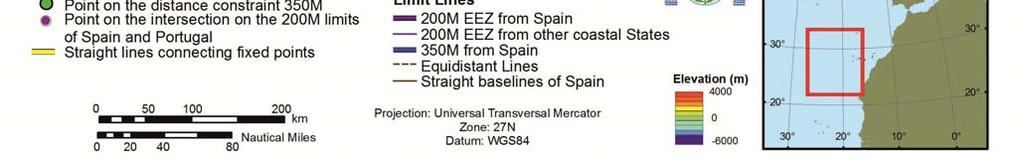
15 Continental Shelf of Spain in the area to the West of the Canary Islands Detailed description of the outer limits of the continental shelf beyond 200 M in the area to the West of the Canary Islands 7 1 Spain delineates the outer limits of its continental shelf beyond 200 M to the West of the Canary Islands by straight lines not exceeding 60 M in length that connect 448 fixed points defined by latitude and longitude coordinates, referred to datum WGS 84, pursuant to article 76, paragraph 7, of the Convention (Figs. 3, 4, 5 and Annex I). 7 2 The first fixed point of this Submission (FP 1) is located at the 200 M equidistance point between Spain and Portugal calculated from Roque de Santo Domingo (island of La Palma, Spain) and Ponta do Pargo (island of Madeira, Portugal). To calculate this point, the official coastal line published in a digital format by the Hydrographic Institute of Portugal (IHPT) was used, available at The fixed points FP 2 to FP 448 are the result of applying the distance formula or the 1% sediment thickness formula as provided for in article 76, paragraph 4, of the Convention. 7 4 Following the procedure established in the Scientific and Technical Guidelines of the Commission (CLCS/11), 29 foot of slope (FOS) points have been determined as the point of maximum change in the gradient within the region defined as the base of the continental slope. To determine these FOS points, a large multibeam bathymetric database was compiled (Fig. 2). The rule applicable to exceptional cases, of "evidence to the contrary", regarding the determination of points of the foot of the continental slope with other criteria different that the maximum change in gradient, as described in article 76, paragraph 4 (b), of the Convention has not been applied. 7 5 The fixed points FP 2 to FP 98, FP 99 to FP 123, FP 124 to FP 131 and FP 388 to FP 448 (Figs. 3, 4 and 5) are the result of applying the Hedberg formula or points placed not more than 60 M from the foot of the continental slope, in accordance with article 76, paragraph 4 (a) (ii), of the Convention.
16 14 Executive Summary The fixed points FP 262, FP 263 and FP 387 (Figs. 3, 4 and 5) are the result of applying the Gardiner formula or points where the thickness of sedimentary rocks is at least 1 per cent of the shortest distance from these points to the foot of the continental slope, in accordance with article 76, paragraph 4 (a) (i), of the Convention. These fixed points have been calculated using a total of 4,736 km of multichannel seismic profiles expressly obtained for this Submission during the GAIRE 2011 oceanographic survey as well as multiple analyses of seismic velocities. Moreover, for each of these fixed points, documentation has been presented in order to demonstrate the sedimentary continuity between these fixed points and the foot of the continental slope, in accordance with paragraph of the Scientific and Technical Guidelines of the Commission (CLCS/11). 7 7 The fixed points FP 132 to FP 208, FP 209 to FP 222, FP 223 to FP 261, FP 264 to FP 386 (Figs. 3, 4 and 5) are placed at a distance of 350 M from the baselines from which the breadth of the territorial sea is measured in accordance with article 76, paragraph 6, of the Convention. 7 8 The outer fixed points of this Submission defined by the combination of the two affirmative formulae rules in the area to the West of the Canary Islands does not exceed 350 M from the baselines from which the breadth of the territorial sea is measured pursuant to the constraints derived from article 76, paragraph 6, of the Convention. 7 9 The baselines applied were defined to the West of La Palma and El Hierro islands (Fig. 3). To the West of the El Hierro Island, the Royal Decree 2510/1977 of 5 August defines, with seven points, the straight baselines from which the breadth of the territorial sea of Spain is measured. To the West of the Island of La Palma, the baseline applied was the low tide line, as no straight baseline has been declared. This low tide line has been drawn through restitution techniques using photogrammetric flights.


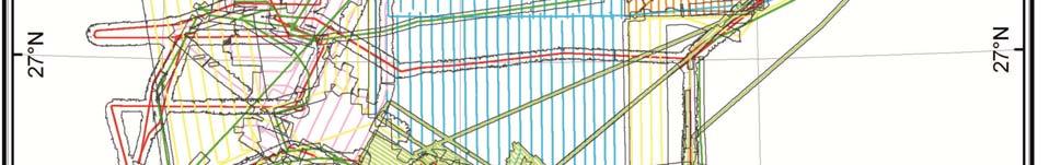
17 Continental Shelf of Spain in the area to the West of the Canary Islands 15 Figure 3: Overview of the outer limits of the continental shelf of Spain beyond 200 nautical miles in the area to the West of the Canary Islands.


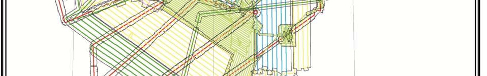
18 16 Executive Summary 16 Figure 4: Detail of the outer limits in the northern zone of the continental shelf of Spain beyond 200 nautical miles in the area to the West of the Canary Islands


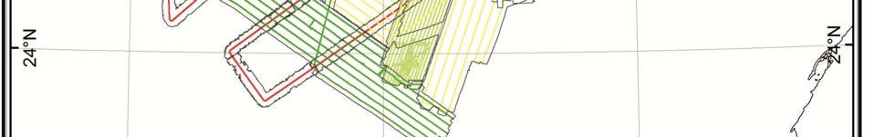
19 Continental Shelf of Spain in the area to the West of the Canary Islands 17 Figure 5: Detail of the outer limits in the southern zone of the continental shelf of Spain beyond 200 nautical miles in the area to the West of the Canary Islands.
20 18 Executive Summary 18 Annex 1. List of coordinates of the fixed points that define the outer limits of the continental shelf of Spain in the area to the West of the Canary Islands FP Latitude North Longitud West Method, Article 76 Distance Fixed point at the 200 M equidistance between Spain and Portugal Fixed point at 60M from FOS_1, Art.76(4) (a) (ii) Fixed point at 60M from FOS_1, Art.76(4) (a) (ii) Fixed point at 60M from FOS_1, Art.76(4) (a) (ii) Fixed point at 60M from FOS_1, Art.76(4) (a) (ii) Fixed point at 60M from FOS_1, Art.76(4) (a) (ii) Fixed point at 60M from FOS_1, Art.76(4) (a) (ii) Fixed point at 60M from FOS_1, Art.76(4) (a) (ii) Fixed point at 60M from FOS_1, Art.76(4) (a) (ii) Fixed point at 60M from FOS_1, Art.76(4) (a) (ii) Fixed point at 60M from FOS_1, Art.76(4) (a) (ii) Fixed point at 60M from FOS _1, Art.76(4) (a) (ii) Fixed point at 60M from FOS_1, Art.76(4) (a) (ii) Fixed point at 60M from FOS_1, Art.76(4) (a) (ii) Fixed point at 60M from FOS_1, Art.76(4) (a) (ii) Fixed point at 60M from FOS_1, Art.76(4) (a) (ii) Fixed point at 60M from FOS_1, Art.76(4) (a) (ii) Fixed point at 60M from FOS_1, Art.76(4) (a) (ii) Fixed point at 60M from FOS_1, Art.76(4) (a) (ii) Fixed point at 60M from FOS_1, Art.76(4) (a) (ii) Fixed point at 60M from FOS_1, Art.76(4) (a) (ii) Fixed point at 60M from FOS_1, Art.76(4) (a) (ii) Fixed point at 60M from FOS_1, Art.76(4) (a) (ii) Fixed point at 60M from FOS_1, Art.76(4) (a) (ii) Fixed point at 60M from FOS_1, Art.76(4) (a) (ii) Fixed point at 60M from FOS_1, Art.76(4) (a) (ii) (M)
21 Continental Shelf of Spain in the area to the West of the Canary Islands 19 FP Latitude North Longitud West Method, Article Fixed point at 60M from FOS_1, Art.76(4) (a) (ii) Fixed point at 60M from FOS_1, Art.76(4) (a) (ii) Fixed point at 60M from FOS_1, Art.76(4) (a) (ii) Fixed point at 60M from FOS_1, Art.76(4) (a) (ii) Fixed point at 60M from FOS_1, Art.76(4) (a) (ii) Fixed point at 60M from FOS_1, Art.76(4) (a) (ii) Fixed point at 60M from FOS_1, Art.76(4) (a) (ii) Fixed point at 60M from FOS_1, Art.76(4) (a) (ii) Fixed point at 60M from FOS_1, Art.76(4) (a) (ii) Fixed point at 60M from FOS_1, Art.76(4) (a) (ii) Fixed point at 60M from FOS_1, Art.76(4) (a) (ii) Fixed point at 60M from FOS_1, Art.76(4) (a) (ii) Fixed point at 60M from FOS_1, Art.76(4) (a) (ii) Fixed point at 60M from FOS_1, Art.76(4) (a) (ii) Fixed point at 60M from FOS_1, Art.76(4) (a) (ii) Fixed point at 60M from FOS_1, Art.76(4) (a) (ii) Fixed point at 60M from FOS_1, Art.76(4) (a) (ii) Fixed point at 60M from FOS_1, Art.76(4) (a) (ii) Fixed point at 60M from FOS_1, Art.76(4) (a) (ii) Fixed point at 60M from FOS_1, Art.76(4) (a) (ii) Fixed point at 60M from FOS_1, Art.76(4) (a) (ii) Fixed point at 60M from FOS_1, Art.76(4) (a) (ii) Fixed point at 60M from FOS_1, Art.76(4) (a) (ii) Fixed point at 60M from FOS_1, Art.76(4) (a) (ii) Fixed point at 60M from FOS_1, Art.76(4) (a) (ii) Fixed point at 60M from FOS_1, Art.76(4) (a) (ii) Fixed point at 60M from FOS_1, Art.76(4) (a) (ii) Fixed point at 60M from FOS_1, Art.76(4) (a) (ii) Fixed point at 60M from FOS_1, Art.76(4) (a) (ii) Distance (M)
22 20 Executive Summary 20 FP Latitude North Longitud West Method, Article Fixed point at 60M from FOS_1, Art.76(4) (a) (ii) Fixed point at 60M from FOS_1, Art.76(4) (a) (ii) Fixed point at 60M from FOS_1, Art.76(4) (a) (ii) Fixed point at 60M from FOS_1, Art.76(4) (a) (ii) Fixed point at 60M from FOS_1, Art.76(4) (a) (ii) Fixed point at 60M from FOS_1, Art.76(4) (a) (ii) Fixed point at 60M from FOS_1, Art.76(4) (a) (ii) Fixed point at 60M from FOS_1, Art.76(4) (a) (ii) Fixed point at 60M from FOS_1, Art.76(4) (a) (ii) Fixed point at 60M from FOS_1, Art.76(4) (a) (ii) Fixed point at 60M from FOS_1, Art.76(4) (a) (ii) Fixed point at 60M from FOS_1, Art.76(4) (a) (ii) Fixed point at 60M from FOS_1, Art.76(4) (a) (ii) Fixed point at 60M from FOS_1, Art.76(4) (a) (ii) Fixed point at 60M from FOS_1, Art.76(4) (a) (ii) Fixed point at 60M from FOS_1, Art.76(4) (a) (ii) Fixed point at 60M from FOS_1, Art.76(4) (a) (ii) Fixed point at 60M from FOS_1, Art.76(4) (a) (ii) Fixed point at 60M from FOS_1, Art.76(4) (a) (ii) Fixed point at 60M from FOS_1, Art.76(4) (a) (ii) Fixed point at 60M from FOS_1, Art.76(4) (a) (ii) Fixed point at 60M from FOS_1, Art.76(4) (a) (ii) Fixed point at 60M from FOS_1, Art.76(4) (a) (ii) Fixed point at 60M from FOS_1, Art.76(4) (a) (ii) Fixed point at 60M from FOS_1, Art.76(4) (a) (ii) Fixed point at 60M from FOS_1, Art.76(4) (a) (ii) Fixed point at 60M from FOS_1, Art.76(4) (a) (ii) Fixed point at 60M from FOS_1, Art.76(4) (a) (ii) Fixed point at 60M from FOS_1, Art.76(4) (a) (ii) Distance (M)
23 Continental Shelf of Spain in the area to the West of the Canary Islands 21 FP Latitude North Longitud West Method, Article Fixed point at 60M from FOS_1, Art.76(4) (a) (ii) Fixed point at 60M from FOS_1, Art.76(4) (a) (ii) Fixed point at 60M from FOS_1, Art.76(4) (a) (ii) Fixed point at 60M from FOS_1, Art.76(4) (a) (ii) Fixed point at 60M from FOS_1, Art.76(4) (a) (ii) Fixed point at 60M from FOS_1, Art.76(4) (a) (ii) Fixed point at 60M from FOS_1, Art.76(4) (a) (ii) Fixed point at 60M from FOS_1, Art.76(4) (a) (ii) Fixed point at 60M from FOS_1, Art.76(4) (a) (ii) Fixed point at 60M from FOS_1, Art.76(4) (a) (ii) Fixed point at 60M from FOS_1, Art.76(4) (a) (ii) Fixed point at 60M from FOS_1, Art.76(4) (a) (ii) Fixed point at 60M from FOS_1, Art.76(4) (a) (ii) Fixed point at 60M from FOS_1, Art.76(4) (a) (ii) Fixed point at 60M from FOS_2, Art.76(4) (a) (ii) Fixed point at 60M from FOS_2, Art.76(4) (a) (ii) Fixed point at 60M from FOS_2, Art.76(4) (a) (ii) Fixed point at 60M from FOS_2, Art.76(4) (a) (ii) Fixed point at 60M from FOS_2, Art.76(4) (a) (ii) Fixed point at 60M from FOS_2, Art.76(4) (a) (ii) Fixed point at 60M from FOS_2, Art.76(4) (a) (ii) Fixed point at 60M from FOS_2, Art.76(4) (a) (ii) Fixed point at 60M from FOS_2, Art.76(4) (a) (ii) Fixed point at 60M from FOS_2, Art.76(4) (a) (ii) Fixed point at 60M from FOS_2, Art.76(4) (a) (ii) Fixed point at 60M from FOS_2, Art.76(4) (a) (ii) Fixed point at 60M from FOS_2, Art.76(4) (a) (ii) Fixed point at 60M from FOS_2, Art.76(4) (a) (ii) Fixed point at 60M from FOS_2, Art.76(4) (a) (ii) Distance (M)
24 22 Executive Summary 22 FP Latitude North Longitud West Method, Article 76 Distance Fixed point at 60M from FOS_2, Art.76(4) (a) (ii) Fixed point at 60M from FOS_2, Art.76(4) (a) (ii) Fixed point at 60M from FOS_2, Art.76(4) (a) (ii) Fixed point at 60M from FOS_2, Art.76(4) (a) (ii) Fixed point at 60M from FOS_2, Art.76(4) (a) (ii) Fixed point at 60M from FOS_2, Art.76(4) (a) (ii) Fixed point at 60M from FOS_2, Art.76(4) (a) (ii) Fixed point at 60M from FOS_2, Art.76(4) (a) (ii) Fixed point at 60M from FOS_2, Art.76(4) (a) (ii) Fixed point at 60M from FOS_2, Art.76(4) (a) (ii) Fixed point at 60M from FOS_9, Art.76(4) (a) (ii) Fixed point at 60M from FOS_9, Art.76(4) (a) (ii) Fixed point at 60M from FOS_9, Art.76(4) (a) (ii) Fixed point at 60M from FOS_9, Art.76(4) (a) (ii) Fixed point at 60M from FOS_9, Art.76(4) (a) (ii) Fixed point at 60M from FOS_9, Art.76(4) (a) (ii) Fixed point at 60M from FOS_9, Art.76(4) (a) (ii) Fixed point at 60M from FOS_9, Art.76(4) (a) (ii) Fixed point at 350 M constraint distance from 60 M + FOS_9, Art.76(5) Fixed point at 350 M constraint distance from 60 M + FOS_9, Art.76(5) Fixed point at 350 M constraint distance from 60 M + FOS_9, Art.76(5) Fixed point at 350 M constraint distance from 60 M + FOS_9,Art.76(5) Fixed point at 350 M constraint distance from 60 M + FOS_9,Art.76(5) Fixed point at 350 M constraint distance from 60 M + FOS_9, Art.76(5) Fixed point at 350 M constraint distance from 60 M + FOS_9,Art.76(5) Fixed point at 350 M constraint distance from 60 M + FOS_9, Art.76(5) Fixed point at 350 M constraint distance from 60 M + FOS_9, Art.76(5) Fixed point at 350 M constraint distance from 60 M + FOS_9, Art.76(5) (M)
25 Continental Shelf of Spain in the area to the West of the Canary Islands 23 FP Latitude North Longitud West Method, Article 76 Distance Fixed point at 350 M constraint distance from 60 M + FOS_9, Art.76(5) Fixed point at 350 M constraint distance from 60 M + FOS_9, Art.76(5) Fixed point at 350 M constraint distance from 60 M + FOS_9, Art.76(5) Fixed point at 350 M constraint distance from 60 M + FOS_9, Art.76(5) Fixed point at 350 M constraint distance from 60 M + FOS_9, Art.76(5) Fixed point at 350 M constraint distance from 60 M + FOS_9, Art.76(5) Fixed point at 350 M constraint distance from 60 M + FOS_9, Art.76(5) Fixed point at 350 M constraint distance from 60 M + FOS_9, Art.76(5) Fixed point at 350 M constraint distance from 60 M + FOS_9, Art.76(5) Fixed point at 350 M constraint distance from 60 M + FOS_9, Art.76(5) Fixed point at 350 M constraint distance from 60 M + FOS_9, Art.76(5) Fixed point at 350 M constraint distance from 60 M + FOS_9, Art.76(5) Fixed point at 350 M constraint distance from 60 M + FOS_9, Art.76(5) Fixed point at 350 M constraint distance from 60 M + FOS_9, Art.76(5) Fixed point at 350 M constraint distance from 60 M + FOS_9, Art.76(5) Fixed point at 350 M constraint distance from 60 M + FOS_9, Art.76(5) Fixed point at 350 M constraint distance from 60 M + FOS_9, Art.76(5) Fixed point at 350 M constraint distance from 60 M + FOS_9, Art.76(5) Fixed point at 350 M constraint distance from 60 M + FOS_9, Art.76(5) Fixed point at 350 M constraint distance from 60 M + FOS_9, Art.76(5) Fixed point at 350 M constraint distance from 60 M + FOS_9, Art.76(5) Fixed point at 350 M constraint distance from 60 M + FOS_9, Art.76(5) Fixed point at 350 M constraint distance from 60 M + FOS_9, Art.76(5) Fixed point at 350 M constraint distance from 60 M + FOS_9, Art.76(5) Fixed point at 350 M constraint distance from 60 M + FOS_9, Art.76(5) Fixed point at 350 M constraint distance from 60 M + FOS_9, Art.76(5) Fixed point at 350 M constraint distance from (M)
26 24 Executive Summary 24 FP Latitude North Longitud West Method, Article 76 Distance 60 M + FOS_9, Art.76(5) Fixed point at 350 M constraint distance from 60 M + FOS_9, Art.76(5) Fixed point at 350 M constraint distance from 60 M + FOS_9, Art.76(5) Fixed point at 350 M constraint distance from 60 M + FOS_9, Art.76(5) Fixed point at 350 M constraint distance from 60 M + FOS_9, Art.76(5) Fixed point at 350 M constraint distance from 60 M + FOS_9, Art.76(5) Fixed point at 350 M constraint distance from 60 M + FOS_9, Art.76(5) Fixed point at 350 M constraint distance from 60 M + FOS_9, Art.76(5) Fixed point at 350 M constraint distance from 60 M + FOS_9, Art.76(5) Fixed point at 350 M constraint distance from 60 M + FOS_9, Art.76(5) Fixed point at 350 M constraint distance from 60 M + FOS_9, Art.76(5) Fixed point at 350 M constraint distance from 60 M + FOS_9, Art.76(5) Fixed point at 350 M constraint distance from 60 M + FOS_9, Art.76(5) Fixed point at 350 M constraint distance from 60 M + FOS_9, Art.76(5) Fixed point at 350 M constraint distance from 60 M + FOS_9, Art.76(5) Fixed point at 350 M constraint distance from 60 M + FOS_9, Art.76(5) Fixed point at 350 M constraint distance from 60 M + FOS_9, Art.76(5) Fixed point at 350 M constraint distance from 60 M + FOS_9, Art.76(5) Fixed point at 350 M constraint distance from 60 M + FOS_9, Art.76(5) Fixed point at 350 M constraint distance from 60 M + FOS_9, Art.76(5) Fixed point at 350 M constraint distance from 60 M + FOS_9, Art.76(5) Fixed point at 350 M constraint distance from 60 M + FOS_9, Art.76(5) Fixed point at 350 M constraint distance from 60 M + FOS_9, Art.76(5) Fixed point at 350 M constraint distance from 60 M + FOS_9, Art.76(5) Fixed point at 350 M constraint distance from 60 M + FOS_9, Art.76(5) Fixed point at 350 M constraint distance from 60 M + FOS_9, Art.76(5) Fixed point at 350 M constraint distance from 60 M + FOS_9, Art.76(5) (M)
27 Continental Shelf of Spain in the area to the West of the Canary Islands 25 FP Latitude North Longitud West Method, Article 76 Distance Fixed point at 350 M constraint distance from 60 M + FOS_9, Art.76(5) Fixed point at 350 M constraint distance from 60 M + FOS_9, Art.76(5) Fixed point at 350 M constraint distance from 60 M + FOS_9, Art.76(5) Fixed point at 350 M constraint distance from 60 M + FOS_9, Art.76(5) Fixed point at 350 M constraint distance from 60 M + FOS_9, Art.76(5) Fixed point at 350 M constraint distance from 60 M + FOS_9, Art.76(5) Fixed point at 350 M constraint distance from 60 M + FOS_9, Art.76(5) Fixed point at 350 M constraint distance from 60 M + FOS_9, Art.76(5) Fixed point at 350 M constraint distance from 60 M + FOS_9, Art.76(5) Fixed point at 350 M constraint distance from 60 M + FOS_9, Art.76(5) Fixed point at 350 M constraint distance from 60 M + FOS_9, Art.76(5) Fixed point at 350 M constraint distance from 60 M + FOS_9, Art.76(5) Fixed point at 350 M constraint distance from 60 M + FOS_9, Art.76(5) Fixed point at 350 M constraint distance from 60 M + FOS_9, Art.76(5) Fixed point at 350 M constraint distance from 60 M + FOS_14, Art.76(5) Fixed point at 350 M constraint distance from 60 M + FOS_14, Art.76(5) Fixed point at 350 M constraint distance from 60 M + FOS_14, Art.76(5) Fixed point at 350 M constraint distance from 60 M + FOS_14, Art.76(5) Fixed point at 350 M constraint distance from 60 M + FOS_14, Art.76(5) Fixed point at 350 M constraint distance from 60 M + FOS_14, Art.76(5) Fixed point at 350 M constraint distance from 60 M + FOS_14, Art.76(5) Fixed point at 350 M constraint distance from 60 M + FOS_14, Art.76(5) Fixed point at 350 M constraint distance from 60 M + FOS_14, Art.76(5) Fixed point at 350 M constraint distance from 60 M + FOS_14, Art.76(5) Fixed point at 350 M constraint distance from 60 M + FOS_14, Art.76(5) Fixed point at 350 M constraint distance from 60 M + FOS_14, Art.76(5) (M)
28 26 Executive Summary 26 FP Latitude North Longitud West Method, Article 76 Distance Fixed point at 350 M constraint distance from 60 M + FOS_14, Art.76(5) Fixed point at 350 M constraint distance from 60 M + FOS_14, Art.76(5) Fixed point at 350 M constraint distance from 60 M + FOS_15, Art.76(5) Fixed point at 350 M constraint distance from 60 M + FOS_15, Art.76(5) Fixed point at 350 M constraint distance from 60 M + FOS_15, Art.76(5) Fixed point at 350 M constraint distance from 60 M + FOS_15, Art.76(5) Fixed point at 350 M constraint distance from 60 M + FOS_15, Art.76(5) Fixed point at 350 M constraint distance from 60 M + FOS_15, Art.76(5) Fixed point at 350 M constraint distance from 60 M + FOS_15, Art.76(5) Fixed point at 350 M constraint distance from 60 M + FOS_15, Art.76(5) Fixed point at 350 M constraint distance from 60 M + FOS_15, Art.76(5) Fixed point at 350 M constraint distance from 60 M + FOS_15, Art.76(5) Fixed point at 350 M constraint distance from 60 M + FOS_15, Art.76(5) Fixed point at 350 M constraint distance from 60 M + FOS_15, Art.76(5) Fixed point at 350 M constraint distance from 60 M + FOS_15, Art.76(5) Fixed point at 350 M constraint distance from 60 M + FOS_15, Art.76(5) Fixed point at 350 M constraint distance from 60 M + FOS_15, Art.76(5) Fixed point at 350 M constraint distance from 60 M + FOS_15, Art.76(5) Fixed point at 350 M constraint distance from 60 M + FOS_15, Art.76(5) Fixed point at 350 M constraint distance from 60 M + FOS_15, Art.76(5) Fixed point at 350 M constraint distance from 60 M + FOS_15, Art.76(5) Fixed point at 350 M constraint distance from 60 M + FOS_15, Art.76(5) Fixed point at 350 M constraint distance from 60 M + FOS_15, Art.76(5) Fixed point at 350 M constraint distance from 60 M + FOS_15, Art.76(5) Fixed point at 350 M constraint distance from 60 M + FOS_15, Art.76(5) Fixed point at 350 M constraint distance from 60 M + FOS_15, Art.76(5) (M)
29 Continental Shelf of Spain in the area to the West of the Canary Islands 27 FP Latitude North Longitud West Method, Article 76 Distance Fixed point at 350 M constraint distance from 60 M + FOS_15, Art.76(5) Fixed point at 350 M constraint distance from 60 M + FOS_15, Art.76(5) Fixed point at 350 M constraint distance from 60 M + FOS_15, Art.76(5) Fixed point at 350 M constraint distance from 60 M + FOS_15, Art.76(5) Fixed point at 350 M constraint distance from 60 M + FOS_15, Art.76(5) Fixed point at 350 M constraint distance from 60 M + FOS_15, Art.76(5) Fixed point at 350 M constraint distance from 60 M + FOS_15, Art.76(5) Fixed point at 350 M constraint distance from 60 M + FOS_15, Art.76(5) Fixed point at 350 M constraint distance from 60 M + FOS_15, Art.76(5) Fixed point at 350 M constraint distance from 60 M + FOS_15, Art.76(5) Fixed point at 350 M constraint distance from 60 M + FOS_15, Art.76(5) Fixed point at 350 M constraint distance from 60 M + FOS_15, Art.76(5) Fixed point on the 350 M constraint line, Art.76(5) Fixed point on the 350 M constraint line, Art.76(5) Fixed point on the 350 M constraint line, Art.76(5) Fixed point from sediment thickness at 1% distance to FOS_19, Art.76(4) (a) (i) Fixed point from sediment thickness at 1% distance to FOS_20, Art.76(4) (a) (i) Fixed point on the 350 M constraint line, Art.76(5) Fixed point on the 350 M constraint line, Art.76(5) Fixed point on the 350 M constraint line, Art.76(5) Fixed point on the 350 M constraint line, Art.76(5) Fixed point on the 350 M constraint line, Art.76(5) Fixed point on the 350 M constraint line, Art.76(5) Fixed point on the 350 M constraint line, Art.76(5) Fixed point on the 350 M constraint line, Art.76(5) Fixed point on the 350 M constraint line, Art.76(5) Fixed point on the 350 M constraint line, Art.76(5) Fixed point on the 350 M constraint line, Art.76(5) (M)
30 28 Executive Summary 28 FP Latitude North Longitud West Method, Article 76 Distance Fixed point on the 350 M constraint line, Art.76(5) Fixed point on the 350 M constraint line, Art.76(5) Fixed point on the 350 M constraint line, Art.76(5) Fixed point on the 350 M constraint line, Art.76(5) Fixed point on the 350 M constraint line, Art.76(5) Fixed point on the 350 M constraint line, Art.76(5) Fixed point at 350 M constraint distance from 60 M + FOS_25, Art.76(5) Fixed point at 350 M constraint distance from 60 M + FOS_25, Art.76(5) Fixed point at 350 M constraint distance from 60 M + FOS_25, Art.76(5) Fixed point at 350 M constraint distance from 60 M + FOS_25, Art.76(5) Fixed point at 350 M constraint distance from 60 M + FOS_25, Art.76(5) Fixed point at 350 M constraint distance from 60 M + FOS_25, Art.76(5) Fixed point at 350 M constraint distance from 60 M + FOS_25, Art.76(5) Fixed point at 350 M constraint distance from 60 M + FOS_25, Art.76(5) Fixed point at 350 M constraint distance from 60 M + FOS_25, Art.76(5) Fixed point at 350 M constraint distance from 60 M + FOS_25, Art.76(5) Fixed point at 350 M constraint distance from 60 M + FOS_25, Art.76(5) Fixed point at 350 M constraint distance from 60 M + FOS_25, Art.76(5) Fixed point at 350 M constraint distance from 60 M + FOS_25, Art.76(5) Fixed point at 350 M constraint distance from 60 M + FOS_25, Art.76(5) Fixed point at 350 M constraint distance from 60 M + FOS_25, Art.76(5) Fixed point at 350 M constraint distance from 60 M + FOS_25, Art.76(5) Fixed point at 350 M constraint distance from 60 M + FOS_25, Art.76(5) Fixed point at 350 M constraint distance from 60 M + FOS_25, Art.76(5) Fixed point at 350 M constraint distance from 60 M + FOS_25, Art.76(5) Fixed point at 350 M constraint distance from 60 M + FOS_25, Art.76(5) Fixed point at 350 M constraint distance from 60 M + FOS_25, Art.76(5) (M)
31 Continental Shelf of Spain in the area to the West of the Canary Islands 29 FP Latitude North Longitud West Method, Article 76 Distance Fixed point at 350 M constraint distance from 60 M + FOS_26, Art.76(5) Fixed point at 350 M constraint distance from 60 M + FOS_26, Art.76(5) Fixed point at 350 M constraint distance from 60 M + FOS_26, Art.76(5) Fixed point at 350 M constraint distance from 60 M + FOS_26, Art.76(5) Fixed point at 350 M constraint distance from 60 M + FOS_26, Art.76(5) Fixed point at 350 M constraint distance from 60 M + FOS_26, Art.76(5) Fixed point at 350 M constraint distance from 60 M + FOS_26, Art.76(5) Fixed point at 350 M constraint distance from 60 M + FOS_26, Art.76(5) Fixed point at 350 M constraint distance from 60 M + FOS_27, Art.76(5) Fixed point at 350 M constraint distance from 60 M + FOS_27, Art.76(5) Fixed point at 350 M constraint distance from 60 M + FOS_27, Art.76(5) Fixed point at 350 M constraint distance from 60 M + FOS_27, Art.76(5) Fixed point at 350 M constraint distance from 60 M + FOS_27, Art.76(5) Fixed point at 350 M constraint distance from 60 M + FOS_27, Art.76(5) Fixed point at 350 M constraint distance from 60 M + FOS_27, Art.76(5) Fixed point at 350 M constraint distance from 60 M + FOS_27, Art.76(5) Fixed point at 350 M constraint distance from 60 M + FOS_27, Art.76(5) Fixed point at 350 M constraint distance from 60 M + FOS_27, Art.76(5) Fixed point at 350 M constraint distance from 60 M + FOS_27, Art.76(5) Fixed point at 350 M constraint distance from 60 M + FOS_27, Art.76(5) Fixed point at 350 M constraint distance from 60 M + FOS_27, Art.76(5) Fixed point at 350 M constraint distance from 60 M + FOS_27, Art.76(5) Fixed point at 350 M constraint distance from 60 M + FOS_27, Art.76(5) Fixed point at 350 M constraint distance from 60 M + FOS_27, Art.76(5) Fixed point at 350 M constraint distance from 60 M + FOS_27, Art.76(5) Fixed point at 350 M constraint distance from 60 M + FOS_27, Art.76(5) (M)
32 30 Executive Summary 30 FP Latitude North Longitud West Method, Article 76 Distance Fixed point at 350 M constraint distance from 60 M + FOS_27, Art.76(5) Fixed point at 350 M constraint distance from 60 M + FOS_27, Art.76(5) Fixed point at 350 M constraint distance from 60 M + FOS_27, Art.76(5) Fixed point at 350 M constraint distance from 60 M + FOS_27, Art.76(5) Fixed point at 350 M constraint distance from 60 M + FOS_27, Art.76(5) Fixed point at 350 M constraint distance from 60 M + FOS_27, Art.76(5) Fixed point at 350 M constraint distance from 60 M + FOS_27, Art.76(5) Fixed point at 350 M constraint distance from 60 M + FOS_27, Art.76(5) Fixed point at 350 M constraint distance from 60 M + FOS_27, Art.76(5) Fixed point at 350 M constraint distance from 60 M + FOS_27, Art.76(5) Fixed point at 350 M constraint distance from 60 M + FOS_27, Art.76(5) Fixed point at 350 M constraint distance from 60 M + FOS_27, Art.76(5) Fixed point at 350 M constraint distance from 60 M + FOS_27, Art.76(5) Fixed point at 350 M constraint distance from 60 M + FOS_27, Art.76(5) Fixed point at 350 M constraint distance from 60 M + FOS_27, Art.76(5) Fixed point at 350 M constraint distance from 60 M + FOS_27, Art.76(5) Fixed point at 350 M constraint distance from 60 M + FOS_27, Art.76(5) Fixed point at 350 M constraint distance from 60 M + FOS_27, Art.76(5) Fixed point at 350 M constraint distance from 60 M + FOS_27, Art.76(5) Fixed point at 350 M constraint distance from 60 M + FOS_27, Art.76(5) Fixed point at 350 M constraint distance from 60 M + FOS_27, Art.76(5) Fixed point at 350 M constraint distance from 60 M + FOS_27, Art.76(5) Fixed point at 350 M constraint distance from 60 M + FOS_27, Art.76(5) Fixed point at 350 M constraint distance from 60 M + FOS_27, Art.76(5) Fixed point at 350 M constraint distance from 60 M + FOS_27, Art.76(5) Fixed point at 350 M constraint distance from 60 M + FOS_27, Art.76(5) (M)
EXECUTIVE SUMMARY A SUBMISSION OF DATA AND INFORMATION ON THE OUTER LIMITS OF THE CONTINENTAL SHELF OF THE REPUBLIC OF NIGERIA PURSUANT TO
 EXECUTIVE SUMMARY A SUBMISSION OF DATA AND INFORMATION ON THE OUTER LIMITS OF THE CONTINENTAL SHELF OF THE REPUBLIC OF NIGERIA PURSUANT TO PART VI OF AND ANNEX II TO THE UNITED NATIONS CONVENTION ON THE
Preliminary Information Indicative of the Outer Limits of the Continental Shelf Beyond 200 Nautical Miles of the People s Republic of China
 (Translation) Preliminary Information Indicative of the Outer Limits of the Continental Shelf Beyond 200 Nautical Miles of the People s Republic of China 1. The People s Republic of China ratified the
EXECUTIVE SUMMARY A PARTIAL SUBMISSION OF DATA AND INFORMATION ON THE OUTER LIMITS OF THE CONTINENTAL SHELF OF THE KINGDOM OF TONGA PURSUANT TO
 EXECUTIVE SUMMARY A PARTIAL SUBMISSION OF DATA AND INFORMATION ON THE OUTER LIMITS OF THE CONTINENTAL SHELF OF THE KINGDOM OF TONGA PURSUANT TO PART VI OF AND ANNEX II TO THE UNITED NATIONS CONVENTION
JOINT SUBMISSION TO THE COMMISSION ON THE LIMITS OF THE CONTINENTAL SHELF BY TUVALU, THE REPUBLIC OF FRANCE AND NEW ZEALAND (TOKELAU)
") JOINT SUBMISSION TO THE COMMISSION ON THE LIMITS OF THE CONTINENTAL SHELF BY TUVALU, THE REPUBLIC OF FRANCE AND NEW ZEALAND (TOKELAU) TABLE OF CONTENTS i. PREFACE... iii ii. LIST OF FIGURES... iv iii.
JOINT SUBMISSION TO THE COMMISSION ON THE LIMITS OF THE CONTINENTAL SHELF BY TUVALU, THE REPUBLIC OF FRANCE AND NEW ZEALAND (TOKELAU) TABLE OF CONTENTS i. PREFACE... iii ii. LIST OF FIGURES... iv iii.
The french national programme for claiming continental shelf beyond 200 Miles
 The french national programme for claiming continental shelf beyond 200 Miles Using global bathymetric models in the context of an Extended Continental Shelf submission EXTRAPLAC Using Global Bathymetric
MAPS AND COORDINATES...
 Table of Contents 1 INTRODUCTION... 2 2 MAPS AND COORDINATES... 3 3 ADVISORY ASSISTANCE FROM COMMISSION MEMBERS... 3 4 PROVISIONS OF ARTICLE 76 INVOKED... 3 5 OUTSTANDING MARITIME DELIMITATIONS... 4 6
IRELAND. PART I Executive Summary
 IRELAND Submission to the Commission on the Limits of the Continental Shelf pursuant to Article 76, paragraph 8 of the United Nations Convention on the Law of the Sea 1982 in respect of the area abutting
CONTINENTAL SHELF SUBMISSION OF ANGOLA - EXECUTIVE SUMMARY -
 CONTINENTAL SHELF SUBMISSION OF ANGOLA - EXECUTIVE SUMMARY - INDEX List of Figures 2 List of Tables 3 1 Introduction 5 2 Provisions of Article 76 7 3 Angolan Institutions responsible for the Submission
OUTER CONTINENTAL SHELF CLAIMS IN THE ARCTIC. Presentation given by Dr. Kamrul Hossain ASA University Bangladesh 15 March 2010
 OUTER CONTINENTAL SHELF CLAIMS IN THE ARCTIC Presentation given by Dr. Kamrul Hossain ASA University Bangladesh 15 March 2010 Contents Historical background of the continental shelf Concept of continental
UNCLOS Article 76- Formulae and constraint lines
 UNCLOS Article 76- Formulae and constraint lines Dr Lindsay Parson (UNCLOS Group, National Oceanography Centre, UK) ABLOS TUTORIAL SESSION - Article 76 of UNCLOS 10th October 2005 IHO/IAG/IOC Advisory
Article 76, variations in annotation and implementation seen in submission documents for the claim of Extended Continental Shelf
 Article 76, variations in annotation and implementation seen in submission documents for the claim of Extended Continental Shelf Mr. Shin Tani Chairman, IHO/IAG Advisory Board on the Law of the Sea (ABLOS)
CONFERENCE OF PARLIAMENTARIANS OF THE ARCTIC REGION. UN LOS Convention and the extended continental shelf in the Arctic
 CONFERENCE OF PARLIAMENTARIANS OF THE ARCTIC REGION UN LOS Convention and the extended continental shelf in the Arctic Presentation given by Dr. Kamrul Hossain Finnish Parliament 18 November 2009 Contents
1982 United Nations Convention on the Law of the Sea
 1982 United Nations Convention on the Law of the Sea Article 16, 47, 75, 76 and 84 Article 16, 47, 75, 76 and 84 require Coastal States to deposit geographic information pertaining to their maritime limits
The Continental Shelf North of the Faroe Islands
 Partial Submission of the Government of the Kingdom of Denmark together with the Government of the Faroes to the Commission on the Limits of the Continental Shelf The Continental Shelf North of the Faroe
The Southern Continental Shelf of Greenland
 Partial Submission of the Government of the Kingdom of Denmark together with the Government of Greenland to the Commission on the Limits of the Continental Shelf The Southern Continental Shelf of Greenland
PRELIMINARY INFORMATION
 PRELIMINARY INFORMATION INDICATIVE OF THE OUTER LIMITS OF THE CONTINENTAL SHELF AND DESCRIPTION OF THE STATUS OF PREPARATION OF MAKING A SUBMISSION TO THE COMMISSION ON THE LIMITS OF THE CONTINENTAL SHELF
Outline of presentation
 - lessons learnt from precedent cases of establishing the s Outline of presentation Extending Ireland s continental shelf jurisdiction to the outer s in the Porcupine Abyssal Plain: progress, issues and
The IHPT Marine Spatial Data infrastructure and its contribution to the INSPIRE Directive
 The IHPT Marine Spatial Data infrastructure and its contribution to the INSPIRE Directive INSPIRE - GWF 2015 - Coastal & Marine session Lisbon Congress Center, Portugal - Thursday, 28 May 2015 Summary
Preliminary Information Indicative of the outer limits of the continental shelf And Description of the status of preparation of making a submission
 Preliminary Information Indicative of the outer limits of the continental shelf And Description of the status of preparation of making a submission To the Commission on the Limits of the Continental Shelf
This Book Belonged to
 THE AMERICAN UNIVERSITY Washington College of Law Library This Book Belonged to The Private Collection of Judge Richard R, Baxter I THE AMERICAN UNIVERSITY Washington College of Law Law Library W-, D.C.
2013 No MARINE MANAGEMENT. The Exclusive Economic Zone Order 2013
 S T A T U T O R Y I N S T R U M E N T S 2013 No. 3161 MARINE MANAGEMENT The Exclusive Economic Zone Order 2013 Made - - - - 11th December 2013 Laid before Parliament 18th December 2013 Coming into force
Law of the Sea Symposium, February, 2016, TOKYO International Law for the Resources of the Sea
 Law of the Sea Symposium, 16-17 February, 2016, TOKYO International Law for the Resources of the Sea Segment 2 Governance of Resources of the Continental Shelf (including extended continental shelf) Introduction
FOOT OF THE CONTINENTAL SLOPE IN ARTICLE 76
 FOOT OF THE CONTINENTAL SLOPE IN ARTICLE 76 Vaughan Stagpoole, Institute of Geological & Nuclear Sciences, Lower Hutt, New Zealand, v.stagpoole@gns.cri.nz Ray Wood, Institute of Geological & Nuclear Sciences,
PORTUGAL NATIONAL REPORT
 PORTUGAL NATIONAL REPORT 13 TH SOUTHERN AFRICA AND ISLANDS HYDROGRAPHIC COMMISSION MEETING Cape Town, South Africa 29 th 31 st August 2016 INSTITUTO HIDROGRÁFICO Miguel Arenga IHPT Head of the Hydrography
DELIMITATION OF THE MOZAMBIQUE MARITIME BOUNDARIES WITH NEIGHBORING STATES (INCLUDING THE EXTENDED CONTINENTAL SHELF) AND MANAGEMENT OF OCEAN ISSUES
 AND MANAGEMENT OF OCEAN ISSUES") DELIMITATION OF THE MOZAMBIQUE MARITIME BOUNDARIES WITH NEIGHBORING STATES (INCLUDING THE EXTENDED CONTINENTAL SHELF) AND MANAGEMENT OF OCEAN ISSUES Elisio B. Jamine United Nations The Nippon Fellowship
DELIMITATION OF THE MOZAMBIQUE MARITIME BOUNDARIES WITH NEIGHBORING STATES (INCLUDING THE EXTENDED CONTINENTAL SHELF) AND MANAGEMENT OF OCEAN ISSUES Elisio B. Jamine United Nations The Nippon Fellowship
Marine Geospatial Software: Generating Economic Benefits from Hydrographic Data and Calculation of Maritime Boundaries
 Marine Geospatial Software: Generating Economic Benefits from Hydrographic Data and Calculation of Serge LEVESQUE and Alexis CARDENAS, Canada Key words: marine geospatial data, hydrography, economic benefits,
ARTICLE 76: THE RIDGE ISSUE
 ARTICLE 76: THE RIDGE ISSUE by Alan EVANS 1, Chris CARLETON 2 and Lindsay PARSON 1 Address 1; Address 2; Southampton Oceanography Centre United Kingdom Hydrographic Office European Way Admiralty Way Southampton
THE MEASUREMENT AND ANALYSIS OF BATHYMETRY, MORPHOLOGY, AND SEDIMENT THICKNESS
 THE MEASUREMENT AND ANALYSIS OF BATHYMETRY, MORPHOLOGY, AND SEDIMENT THICKNESS Ron Macnab Geological Survey of Canada (Retired) OUTLINE OF PRESENTATION Principles and practice of: Echo-sounding Seismic
The Relevance of Hydrography to UNCLOS; an Indonesian Perspective By: Prof. Dr. Hasjim Djalal, MA*
 The Relevance of Hydrography to UNCLOS; an Indonesian Perspective By: Prof. Dr. Hasjim Djalal, MA* As I understand it, the theme of this 6 th ABLOS Conference 2010 is Contentious Issues in UNCLOS- surely
Legal Interpretation of Submarine Ridges & Submarine Elevations
 Legal Interpretation of Ridges & Article 76, paragraph 6 New Knowledge and Changing Circumstances in the Law of the Sea Reykjavik, Iceland June 28, 2018 Kevin Baumert U.S. Department of State U.S. ECS
FEDERAL AUTHORITIES RESPONSIBLE FOR THE PREPARATION: Ministry of Foreign Affairs of the Russian Federation
 FEDERAL AUTHORITIES RESPONSIBLE FOR THE PREPARATION: Ministry of Natural Resources and Environment of the Russian Federation Federal Agency on Mineral Resources Ministry of Natural Resources and Environment
Does Ascension Island have an outer continental shelf?
 Does Ascension Island have an outer continental shelf? Robin Cleverly UK Hydrographic Office Lindsay Parson NOC, Southampton (with Alan Evans, Peter Hunter, Rosemary Edwards of NOC and Chris Carleton of
SOLVING THE RIDGES ENIGMA OF ARTICLE 76 OF THE UNITED NATIONS CONVENTION ON THE LAW OF THE SEA. Written by: George Taft Presented by: George Taft
 SOLVING THE RIDGES ENIGMA OF ARTICLE 76 OF THE UNITED NATIONS CONVENTION ON THE LAW OF THE SEA Written by: George Taft Presented by: George Taft (The views contained herein are those of the author and
PORTUGAL NATIONAL REPORT
 PORTUGAL NATIONAL REPORT 14 TH MEETING OF THE EASTERN ATLANTIC HYDROGRAPHIC COMMISSION Cadiz, Spain 18 th 20 th October 2016 INSTITUTO HIDROGRÁFICO Miguel Arenga IHPT Head of the Hydrography Division 2016-10-18
Operating conditions in the Arctic: Data acquisition in the Arctic Ocean by the Continental Shelf Project of the Kingdom of Denmark
 Operating conditions in the Arctic: Data acquisition in the Arctic Ocean by the Continental Shelf Project of the Kingdom of Denmark By Christian Marcussen Geological Survey of Denmark and Greenland Danish
Coordinates : A - of midpoint or summit : Lat., Long. } to. Description (kind of feature) : seachannel
 : seachannel") INTERNATIONAL HYDROGRAPHIC ORGANIZATION INTERGOVERNMENTAL OCEANOGRAPHIC COMMISSION (of UNESCO) IHO/IOC Form No. 1 UNDERSEA FEATURE NAME PROPOSAL (See NOTE overleaf) Ocean or Sea Japan Sea Name proposed
INTERNATIONAL HYDROGRAPHIC ORGANIZATION INTERGOVERNMENTAL OCEANOGRAPHIC COMMISSION (of UNESCO) IHO/IOC Form No. 1 UNDERSEA FEATURE NAME PROPOSAL (See NOTE overleaf) Ocean or Sea Japan Sea Name proposed
BRAZILIAN SOUTHERN MARGIN: AN EXAMPLE OF THE IDENTIFICATION OF THE BASE OF THE SLOPE ON A PASSIVE CONTINENTAL MARGIN
 BRAZILIAN SOUTHERN MARGIN: AN EXAMPLE OF THE IDENTIFICATION OF THE BASE OF THE SLOPE ON A PASSIVE CONTINENTAL MARGIN Luiz Carlos Torres Brazilian Navy Hydrographic Center Izabel King Jeck Brazilian Navy
UNDERSEA FEATURE NAME PROPOSAL (Sea NOTE overleaf)
") INTERNATIONAL HYDROGRAPHIC ORGANIZATION INTERGOVERNMENTAL OCEANOGRAPHIC COMMISSION (of UNESCO) Note: The boxes will expand as you fill the form. UNDERSEA FEATURE NAME PROPOSAL (Sea NOTE overleaf) Name
INTERNATIONAL HYDROGRAPHIC ORGANIZATION INTERGOVERNMENTAL OCEANOGRAPHIC COMMISSION (of UNESCO) Note: The boxes will expand as you fill the form. UNDERSEA FEATURE NAME PROPOSAL (Sea NOTE overleaf) Name
Finding the continental shelf integration of geology and geophysics
 Finding the continental shelf integration of geology and geophysics R Wood Institute of Geological and Nuclear Sciences, PO Box 30-368, Lower Hutt, Telephone 64-4-570 4867, Fax 64-4-570 4803, Email r.wood@gns.cri.nz
Portuguese Task Group for the Extension of the Continental Shelf (EMEPC)
") Portuguese Task Group for the Extension of the Continental Shelf (EMEPC) Teresa Rafael November 13 th 2017 DGRM Agenda 1. EMEPC competences 2. Initial Assessment Report - Extended continental shelf 3.
Portuguese Task Group for the Extension of the Continental Shelf (EMEPC) Teresa Rafael November 13 th 2017 DGRM Agenda 1. EMEPC competences 2. Initial Assessment Report - Extended continental shelf 3.
IHO Input to the Report of the UN Secretary General on Oceans and Law of the Sea Executive Summary General
 IHO Input to the Report of the UN Secretary General on Oceans and Law of the Sea The following notes provide information on activities of the International Hydrographic Organization that are relevant to
Clive Schofield * and David Freestone **
 Holding Back the Waves: Options to Secure Maritime Jurisdictional Claims in the Face of Sea Level Rise Clive Schofield * and David Freestone ** *Australian National Centre for Ocean Resources and Security
The Continental Shelf Project: An overview of research activities in the Arctic Ocean on behalf of the Kingdom of Denmark
 The Continental Shelf Project: An overview of research activities in the Arctic Ocean on behalf of the Kingdom of Denmark Geological Survey of Denmark and Greenland Ministry of Climate and Energy John
Bathymetric data acquisition in Arctic waters
 Bathymetric data acquisition in Arctic waters within the Danish Continental Shelf Project Morten Sølvsten, Uni Bull, Richard Pedersen & Christian Marcussen Arctic-Antarctic Seafloor Mapping Meeting 2011
Ocean Governance and the Japanese Basic Act on Ocean Policy
 Ocean Governance and the Japanese Basic Act on Ocean Policy Hiroshi Terashima Executive Director Ocean Policy Research Foundation 14 April 2009 The United Nations Nippon Foundation Fellowship Programme
Limits in the Seas. No. 96 June 6, Greece Italy. Continental Shelf Boundary. (Country Codes: GR-IT)
") Limits in the Seas No. 96 June 6, 1982 Greece Italy Continental Shelf Boundary (Country Codes: GR-IT) The Geographer Office of the Geographer Bureau of Intelligence and Research INTERNATIONAL BOUNDARY
Limits in the Seas No. 96 June 6, 1982 Greece Italy Continental Shelf Boundary (Country Codes: GR-IT) The Geographer Office of the Geographer Bureau of Intelligence and Research INTERNATIONAL BOUNDARY
APPLICATION FOR THE CONSENT TO CONDUCT MARINE SCIENTIFIC RESEARCH IN AREAS UNDER NATIONAL JURISDICTION OF THE UNITED KINGDOM
 APPLICATION FOR THE CONSENT TO CONDUCT MARINE SCIENTIFIC RESEARCH IN AREAS UNDER NATIONAL JURISDICTION OF THE UNITED KINGDOM 1. General information Date: 27 th January 2011 1.1 Cruise name and/or number:
ANNEX 23 RESOLUTION MSC.231(82) ADOPTION OF AMENDMENTS TO THE EXISTING MANDATORY SHIP REPORTING SYSTEM IN THE GULF OF FINLAND
 ADOPTION OF AMENDMENTS TO THE EXISTING MANDATORY SHIP REPORTING SYSTEM IN THE GULF OF FINLAND") RESOLUTION MSC.231(82) (adopted on 5 December 2006) ADOPTION OF AMENDMENTS TO THE EXISTING MANDATORY SHIP REPORTING SYSTEM IN THE GULF OF FINLAND THE MARITIME SAFETY COMMITTEE, RECALLING Article 28(b)
RESOLUTION MSC.231(82) (adopted on 5 December 2006) ADOPTION OF AMENDMENTS TO THE EXISTING MANDATORY SHIP REPORTING SYSTEM IN THE GULF OF FINLAND THE MARITIME SAFETY COMMITTEE, RECALLING Article 28(b)
MARITIME PLANNING IN PORTUGAL
 MARITIME PLANNING IN PORTUGAL Marta Chantal Ribeiro 2 May 2007 In Portugal there is currently no strategic planning system in force for the maritime area as a whole The maritime area under Portuguese jurisdiction
Economic and Social Council
 United Nations Economic and Social Council Distr.: General 25 May 2012 Original: English E/CONF.101/113 Tenth United Nations Conference on the Standardization of Geographical Names New York, 31 July 9
Tore Henriksen a & Geir Ulfstein b a Faculty of Law, University of Tromsø, Tromsø, Norway. Available online: 18 Feb 2011
 This article was downloaded by: [Bibliotheek van het Vredespaleis] On: 03 May 2012, At: 03:44 Publisher: Taylor & Francis Informa Ltd Registered in England and Wales Registered Number: 1072954 Registered
ECONOMIC AND SOCIAL COUNCIL 10 July 2007
 UNITED NATIONS E/CONF.98/CRP.22 ECONOMIC AND SOCIAL COUNCIL 10 July 2007 Ninth United Nations Conference on the Standardization of Geographical Names New York, 21-30 August 2007 Item 9(a) of the provisional
SIXTH REGULAR SESSION, 2017 C.B. NO A BILL FOR AN ACT
 NINETEENTH CONGRESS OF THE FEDERATED STATES OF MICRONESIA SIXTH REGULAR SESSION, 0 C.B. NO. - A BILL FOR AN ACT To amend title of the code of the Federated States of Micronesia by amending existing sections
GEBCO 2013 TSCOM. EMODNET Hydrography status report
 www.emodnet-hydrography.eu GEBCO 2013 TSCOM EMODNET Hydrography status report Eric Moussat, Ifremer on behalf of the Emodnet consortium 1 Background and objectives EU proposed to take steps in 2008 towards
UNDERSEA FEATURE NAME PROPOSAL (See NOTE overleaf) Ocean or Sea Atlantic Ocean Name proposed Jean Charcot Seamounts. kilometres in direction from
 Ocean or Sea Atlantic Ocean Name proposed Jean Charcot Seamounts. kilometres in direction from") INTERNATIONAL HYDROGRAPHIC ORGANIZATION INTERGOVERNMENTAL OCEANOGRAPHIC COMMISSION (of UNESCO) IHO/IOC Form No. 1 UNDERSEA FEATURE NAME PROPOSAL (See NOTE overleaf) Ocean or Sea Atlantic Ocean Name proposed
INTERNATIONAL HYDROGRAPHIC ORGANIZATION INTERGOVERNMENTAL OCEANOGRAPHIC COMMISSION (of UNESCO) IHO/IOC Form No. 1 UNDERSEA FEATURE NAME PROPOSAL (See NOTE overleaf) Ocean or Sea Atlantic Ocean Name proposed
Sam Bateman and. State Practice Regarding Straight Baselines In East Asia Legal, Technical and Political Issues in a
 State Practice Regarding Straight Baselines In East Asia Legal, Technical and Political Issues in a Changing Environment Sam Bateman and Clive Schofield The Australian National Centre for Ocean Resources
Economic and Social Council 10 July 2013
 ADVANCE UNEDITED VERSION UNITED NATIONS E/C.20/2013/10/Add.1 Economic and Social Council 10 July 2013 Committee of Experts on Global Geospatial Information Management Third session Cambridge, United Kingdom
The Automated Delimitation of Maritime Boundaries - An Australian Perspective
 The Automated Delimitation of Maritime Boundaries - An Australian Perspective P.A. Collier, B.A. Murphy, D.J. Mitchell and F.J. Leahy, Department of Geomatics, The University of Melbourne, Australia Determining
GeomaticsWorld. Issue No 3 : Volume 21. Helping to unravel Easter Island s mysterious statues. DGI 2013: maritime security highlighted
 GeomaticsWorld MARCH APRIL 2013 Issue No 3 : Volume 21 BIM: repeat the message even if you lose the will to live Helping to unravel Easter Island s mysterious statues DGI 2013: maritime security highlighted
Seafloor Mapping in the High Arctic: The Challenges and the Joys
 Seafloor Mapping in the High Arctic: The Challenges and the Joys Larry Mayer Center for Coastal and Ocean Mapping / NOAA- UNH Joint Hydrographic Center University of New Hampshire, USA Martin Jakobsson
Lawrence A. Lawver Ian W.D. Dalziel Robert Larter University of Texas at Austin, Institute for Geophysics British Antarctic Survey
 20 August 2012 Prof. Hans-Werner Schenke, Chairman GEBCO Sub-Committee on Undersea Feature Names (SCUFN) International Hydrographic Bureau (IHB) 4, Quai Antoine 1er B.P. 445 MC 98011 MONACO CEDEX Principality
Law No. 41 of 1 June 1979 concerning the Territorial Sea, the Economic Zone and the Continental Shelf. I The territorial sea
 Page 1 Law No. 41 of 1 June 1979 concerning the Territorial Sea, the Economic Zone and the Continental Shelf I The territorial sea Article 1. The territorial sea of Iceland shall be delimited by a line
HOW TO DEFINE THE BASE OF THE SLOPE IN LOW GRADIENT PASSIVE MARGINS? BRAZILIAN CONTINENTAL SHELF PROJECT (LEPLAC)
") HOW TO DEFINE THE 1 BASE OF THE SLOPE IN LOW GRADIENT PASSIVE MARGINS? BRAZILIAN CONTINENTAL SHELF PROJECT (LEPLAC) Izabel King Jeck Commander, DHN, Brazilian Navy izabel@dhn.mar.mil.br How to apply art.76
HOW TO DEFINE THE 1 BASE OF THE SLOPE IN LOW GRADIENT PASSIVE MARGINS? BRAZILIAN CONTINENTAL SHELF PROJECT (LEPLAC) Izabel King Jeck Commander, DHN, Brazilian Navy izabel@dhn.mar.mil.br How to apply art.76
REPUBLIC OF THE MARSHALL ISLANDS MARITIME ZONES DECLARATION ACT 2016.
 Republic of the Marshall Islands Maritime Zones Declaration Act 2016. 33MIRCCh.1Index TITLE 33 - MARINE ZONES AND PROTECTION OF MAMMALS CHAPTER 1 - MARITIME ZONE DECLARATION s Republic of the Marshall
Outer Continental Shelf
 The Delimitation of the Outer Continental Shelf Presentation by Stephen Fietta Monaco, 17 October 2008 Latham & Watkins is the business name of Latham & Watkins (London) LLP, a registered limited liability
State Practice on the Establishment of Multiple Maritime Boundaries: Assessing the Challenges of Separating Seabed and Water Column Boundaries
 State Practice on the Establishment of Multiple Maritime Boundaries: Assessing the Challenges of Separating Seabed and Water Column Boundaries Professor Clive Schofield The Australian National Centre for
xxv PART I THE DIVIDED OCEANS: INTERNATIONAL LAW GOVERNING JURISDICTIONAL ZONES 1
 Contents Preface page xv List of Figures xvii List of Tables xviii List of Abbreviations xix Table of Cases xxi Table of Treaties and Instruments xxv PART I THE DIVIDED OCEANS: INTERNATIONAL LAW GOVERNING
Some Thoughts on Maritime Delimitation among the Northeast Asian States
 Some Thoughts on Maritime Delimitation among the Northeast Asian States Seokwoo LEE Assistant Professor College of Law INHA University Korea leeseokwoo@inha.ac.kr 1 I. Common geographical features II.
UNDERSEA FEATURE NAME PROPOSAL (Sea NOTE overleaf)
") INTERNATIONAL HYDROGRAPHIC ORGANIZATION INTERGOVERNMENTAL OCEANOGRAPHIC COMMISSION (of UNESCO) Note: The boxes will expand as you fill the form. UNDERSEA FEATURE NAME PROPOSAL (Sea NOTE overleaf) Name
INTERNATIONAL HYDROGRAPHIC ORGANIZATION INTERGOVERNMENTAL OCEANOGRAPHIC COMMISSION (of UNESCO) Note: The boxes will expand as you fill the form. UNDERSEA FEATURE NAME PROPOSAL (Sea NOTE overleaf) Name
Mindful of the interests which the Parties share as immediate neighbours, and in a spirit of cooperation, friendship and goodwill; and
 page 1 Delimitation Treaties Infobase accessed on 13/03/2002 Treaty between the Government of Australia and the Government of the Republic of Indonesia establishing an exclusive economic zone boundary
A scientific challenge to the delineation of Japan s continental shelf
 Research paper A scientific challenge to the delineation of Japan s continental shelf - Contribution to validating the Japan s rights over marine areas based on earth science- Akira Nishimura * 1, Makoto
Report of the United Kingdom Division
 UNITED NATIONS GROUP OF EXPERTS WORKING PAPER ON GEOGRAPHICAL NAMES NO. 41/4 Twenty-ninth session Bangkok, Thailand, 25 29 April 2016 Item 4 of the Provisional Agenda Report of the Divisions Report of
R E P U B L I C O F C Y P R U S. NATIONAL REPORT OF CYPRUS TO THE 19 th MEDITERRANEAN AND BLACK SEAS HYDROGRAPHIC COMMISSION (MBSHC)
") R E P U B L I C O F C Y P R U S NATIONAL REPORT OF CYPRUS TO THE 19 th MEDITERRANEAN AND BLACK SEAS HYDROGRAPHIC COMMISSION (MBSHC) BATUMI MEETING 30 JUNE TO 02 JULY 2015 NATIONAL REPORT OF CYPRUS TO THE
R E P U B L I C O F C Y P R U S NATIONAL REPORT OF CYPRUS TO THE 19 th MEDITERRANEAN AND BLACK SEAS HYDROGRAPHIC COMMISSION (MBSHC) BATUMI MEETING 30 JUNE TO 02 JULY 2015 NATIONAL REPORT OF CYPRUS TO THE
Underwater Parks: Three Case Studies, and a Primer on Marine Boundary Issues. Robert E. Johnson Leland F. Thormahlen
 Robert E. Johnson Leland F. Thormahlen Underwater Parks: Three Case Studies, and a Primer on Marine Boundary Issues Unlike boundaries on land, most marine boundaries are not marked with monuments or fences.
The role of the Italian Navy Hydrographic Institute in the Arctic activities
 The role of the Italian Navy Hydrographic Institute in the Arctic activities Luigi Sinapi Director of the Italian Hydrographic Institute Early Arctic hydrographic surveys ICE ICE Arctic hydrographic monitoring
HAMILTON DECLARATION ON COLLABORATION FOR THE CONSERVATION OF THE SARGASSO SEA
 HAMILTON DECLARATION ON COLLABORATION FOR THE CONSERVATION OF THE SARGASSO SEA Hamilton, Bermuda 11 March, 2014 WE, THE SIGNATORIES LISTED BELOW: Recognising that the islands of Bermuda are the only land
THE INTERNATIONAL HYDROGRAPHIC ORGANIZATION AND ITS INVOLVEMENT WITH GEOGRAPHICAL PLACE NAMES
 International Hydrographie Review, Monaco, LXXV(1), March 1998 THE INTERNATIONAL HYDROGRAPHIC ORGANIZATION AND ITS INVOLVEMENT WITH GEOGRAPHICAL PLACE NAMES by Adam J. KERR' INTRODUCTION It may be useful
ADMINISTRATION OF GEOGRAPHICAL NAMES IN URUGUAY
 ADMINISTRATION OF GEOGRAPHICAL NAMES IN URUGUAY 1st. Lt. Julio C. Teixeira Executive Officer Geodesy & Topography Division Military Geographic Service Av. 8 de Octubre 3255. Montevideo, URUGUAY Telph.:
MARINE GEOLOGY & GEOGRAPHY
 MARINE GEOLOGY & GEOGRAPHY Bathymetry BATHYMETRY BATHYMETRY THE UNDERWATER EQUIVALENT TO TOPOGRAPHY THE STUDY OF WATER DEPTH A BATHYMETRIC MAP SHOWS FLOOR RELIEF OR TERRAIN AS CONTOUR LINES Bathymetry
Maritime Standards. Rafael Ponce Tom De Puyt
 Maritime Standards Rafael Ponce Tom De Puyt Content The International Hydrographic Organization - Overview - Existing Support - Committees and Working Groups - Technology - Runtime - MCS Next Generation
UNDERSEA FEATURE NAME PROPOSAL (Sea NOTE overleaf)
") INTERNATIONAL HYDROGRAPHIC ORGANIZATION INTERGOVERNMENTAL OCEANOGRAPHIC COMMISSION (of UNESCO) UNDERSEA FEATURE NAME PROPOSAL (Sea NOTE overleaf) Note: The boxes will expand as you fill the form. Name
INTERNATIONAL HYDROGRAPHIC ORGANIZATION INTERGOVERNMENTAL OCEANOGRAPHIC COMMISSION (of UNESCO) UNDERSEA FEATURE NAME PROPOSAL (Sea NOTE overleaf) Note: The boxes will expand as you fill the form. Name
Briefing document of the status of maritime boundaries in Pacific island countries
 Secretariat of the Pacific Community Seventh Heads of Fisheries Meeting (28 Feb. 4 March 2011, Noumea, New Caledonia) Working Paper 5 Original: English Briefing document of the status of maritime boundaries
Selection of Algorithms to Determine Foot of the Continental Slope to Delineate the Extended of the Continental Shelf
 Selection of Algorithms to Determine Foot of the Continental Slope to Delineate the Extended of the Continental Shelf Nawi ABDULLAH, Malaysia Key words: Geoinformation/GI; Hydrography; Legislation; Extended
The Agreement Concerning the Boundary Line Dividing Parts of the Continental Shelf Between Iran and the United Arab Emirates states that:
 2 The Imperial Government of Iran and the Government of the State of the United Arab Emirates (Dubai) signed an agreement on August 31, 1974, regarding the delimitation of their continental shelf boundary.
PRINCIPLES AND APPLICATIONS of OCEAN FEATURE NOMENCLATURE
 PRINCIPLES AND APPLICATIONS of OCEAN FEATURE NOMENCLATURE Michel HUET International Hydrographic Bureau MONACO "Undersea feature" is a part of the ocean floor or seabed that has measurable relief or is
Pacific Islands Regional Maritime Boundaries Project
 Pacific Islands Regional Maritime Boundaries Project 31 st Star Conference, Nadi, FIJI 6-8 June 2016 Jens Kruger Head of Ocean & Coastal Geoscience Sector Andrick Lal Project Officer (Surveying) Emily
ITLOS s approach to the delimitation of the continental shelf beyond 200 M in Bangladesh/Myanmar: Theoretical and practical difficulties
 ITLOS s approach to the delimitation of the continental shelf beyond 200 M in Bangladesh/Myanmar: Theoretical and practical difficulties London International Boundary Conference 18-19 April 2013 Panel
ADOPTION OF THE NEW PUBLICATION S-5B EDITION STANDARDS OF COMPETENCE FOR HYDROGRAPHIC SURVEYORS, CATEGORY B
 IHB File No. AB-4/S-5 CIRCULAR LETTER 90/2015 17 December 2015 ADOPTION OF THE NEW PUBLICATION S-5B EDITION 1.0.0 STANDARDS OF COMPETENCE FOR HYDROGRAPHIC SURVEYORS, CATEGORY B Reference: IHO CL 53/2015
Future Ocean Floor Mapping: Ocean Stewardship & Initial Industry Contributions. U.S Hydro Galveston, TX March 23, 2017 David Millar - Fugro
 Future Ocean Floor Mapping: Ocean Stewardship & Initial Industry Contributions U.S Hydro 2017 - Galveston, TX March 23, 2017 David Millar - Fugro Presentation Outline The Need for Ocean Mapping GEBCO GEBCO
BUDGET. Investigation of natural sand transport on the Belgian continental shelf
 BUDGET Investigation of natural sand transport on the Belgian continental shelf Funded by Federal Office for Scientific, Technical and Cultural Affairs Program: Sustainable Management of the North Sea
Polar complications in the law of the sea: A case study of the regime for research and survey activities in the Arctic Ocean
 2010 ABLOS Conference: Contentious Issues in UNCLOS Surely Not? International Hydrographic Bureau, 25-27 October 2010 Polar complications in the law of the sea: A case study of the regime for research
Finnish Maritime Administration BULLETIN 5/
 Finnish Maritime Administration BULLETIN 5/23.5.2008 VOLUNTARY BALLAST WATER EXCHANGE IN THE NORTH-EAST ATLANTIC AND THE BALTIC SEA Invasive non-indigenous species, contained in ships ballast water, may
North Sea Ballast Water Exchange Area
 HELSINKI and OSPAR COMMISSIONS HELCOM/OSPAR TG BALLAST 8-2017 Joint HELCOM/OSPAR Task Group on Ballast Water Management Convention Exemptions Eighth Meeting Helsinki, Finland, 16-17 November 2017 Document
GIS, Charts and UNCLOS Can they live together?
 GIS, Charts and UNCLOS Can they live together? Bill Hirst 1 and David Robertson 2 Address 1 Geoscience Australia GPO Box 378 Canberra, ACT 2601 Phone: 02 6249 9741 Fax: 02 6249 9939 Email: Bill.Hirst@ga.gov.au
Marine Science and Oceanography
 Marine Science and Oceanography Marine geology- study of the ocean floor Physical oceanography- study of waves, currents, and tides Marine biology study of nature and distribution of marine organisms Chemical
2. Law No. 6 of 1996 on Indonesian Waters (State Gazette of 1996 No. 73, Additional State Gazette of the Republic of Indonesia No.
 Government Reiplatlon No. 61 of 1998 on the list of ~eomaphical - - coordinates of the base DO& of the archi~la~ic baselines of Indonesia in the The President of the Republic of Indonesia Considering:
International Boundary Study
 International Boundary Study Series A Limits in the Seas No. 1 January 21, 1970 Indonesia Malaysia Continental Shelf Boundary (Country Codes: ID-MY) The Geographer Office of the Geographer Bureau of Intelligence
COMPLICATIONS IN DELIMITING THE OUTER CONTINENTAL SHELF. Ron Macnab Geological Survey of Canada (Retired)
") COMPLICATIONS IN DELIMITING THE OUTER CONTINENTAL SHELF Ron Macnab Geological Survey of Canada (Retired) DISCLAIMER The contents of this presentation are the author s personal views only, and do not represent
COMPLICATIONS IN DELIMITING THE OUTER CONTINENTAL SHELF Ron Macnab Geological Survey of Canada (Retired) DISCLAIMER The contents of this presentation are the author s personal views only, and do not represent
NATIONAL REPORT TO THE 6 TH SOUTHERN AFRICAN AND ISLANDS HYDROGRAPHIC COMMISSION MEETING TO BE HELD IN PREPARED BY B. N. OWIN0
 REPUBLIC OF KENYA NATIONAL REPORT TO THE 6 TH SOUTHERN AFRICAN AND ISLANDS HYDROGRAPHIC COMMISSION MEETING TO BE HELD IN MANGOCHI, MALAWI, 27th 28 th AUGUST, 2007. PREPARED BY B. N. OWIN0 SENIOR ASSISTANT
Turkey National Report
 UNITED NATIONS Working Paper GROUP OF EXPERTS ON No. 26 GEOGRAPHICAL NAMES Twenty-third Session Vienna, 28 March 4 April 2006 Item 5 of the Provisional Agenda: Reports of the division Turkey National Report