UNCLOS Article 76- Formulae and constraint lines
|
|
|
- Juliet Osborne
- 5 years ago
- Views:
Transcription


1 UNCLOS Article 76- Formulae and constraint lines Dr Lindsay Parson (UNCLOS Group, National Oceanography Centre, UK) ABLOS TUTORIAL SESSION - Article 76 of UNCLOS 10th October 2005 IHO/IAG/IOC Advisory Board on the Law of the Sea
2 Maritime Limits 12M 200M ~350M Territorial Sea H I G H S E A S High Seas Freedoms Land Baseline Freedoms (Article 58): Navigation Overflight Laying of cables/pipelines Additional freedoms: Fishing Scientific Research Internal waters Sovereign Rights Exclusive Economic Zone Continental Shelf Extended Continental Shelf The Area Not to scale
3 Article 76 - paragraph 1 The continental shelf of a coastal State comprises the seabed and subsoil of the submarine areas that extend beyond its territorial sea throughout the natural prolongation of its land territory to the outer edge of the continental margin, or to a distance of 200 nautical miles from the baselines from which the breadth of the territorial sea is measured where the outer edge of the continental margin does not extend up to that distance.

4 Exclusive Economic Zones (200M )
5 UNCLOS Article 76 - paragraph 3 The continental margin comprises: Submerged prolongation of the land mass of the coastal state; Consists of the seabed and subsoil of the shelf, slope and rise; Does not include the deep ocean floor (with its oceanic ridges or the subsoil thereof).
6 Continental Margin - no Article 76 claim Exclusive Economic Zone 200M km Baseline Shelf Slope Rise Abyssal Plain
7 Wide Continental Shelf - potential for Article 76 claim EEZ 200M km Baseline Shelf Slope 3 4 Rise Abyssal Plain
8 Legal definition of the outer limits of a continental shelf beyond 200 nautical miles: the formulae lines - paragraph 4 Claim lines for the outer limit are straight lines joining points no more than 60M apart The claimant must establish that at each point, either: The thickness of sedimentary rock is 1% of the distance to the nearest point on the foot of the slope The distance to the nearest point on the foot of the slope is 60M Whichever is the greater
9 Determination of the outer edge of the continental margin by sediment thickness - para 4a (i) Baseline Continental margin Sediments Foot of slope 1 % of distance to foot of slope Crystalline continental crust Oceanic crust Nautical mile( M )
10 Definition of sediment thickness The sediment thickness at any location on the continental margin is the vertical distance from the sea floor to the top of the basement at the base of the sediments, regardless of the slope of the sea floor or the slope of the top basement surface. CLCS/11, paragraph 8.1.8
11 Seismic reflection profiling * Shot 1 * Shot 2 CDP
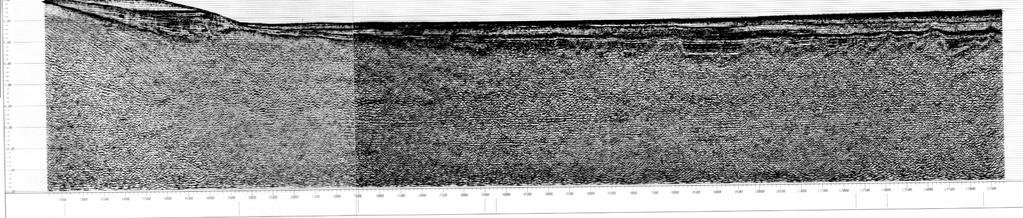
12 Multichannel seismic records

13 Interpreted basement and sediment sections
14 Depth conversion The estimation of sediment thickness requires the depth conversion of the interpreted profiles and maps. This depth conversion of the geophysical data should be documented by the relevant database and the description of the method applied. CLCS/11, paragraph Depth conversion of seismic data requires velocity data to build a velocity model for the sediment wedge. Such velocity models describe the vertical and/or lateral variation in seismic propagation velocities within the sedimentary sequences. CLCS/11, paragraph 8.3.9
15 Sonobuoy Data - to derive time/depth conversion * * * * * * * V 1 V 2

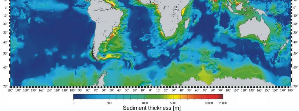
16 Global sediment thickness distribution
17 Data sources (mainly reflection seismic) Regional government/industry surveys for continental margin reconnaissance mapping Localised, detailed 2D and 3D industry surveys for hydrocarbon exploration Detailed 2D site surveys for scientific drilling programs Widely spaced and scattered academic/oceanographic institution surveys
18 Foot of Slope? In the absence of evidence to the contrary, the foot of the continental slope shall be determined as the point of maximum change in the gradient at its base. (Art 76/4b)
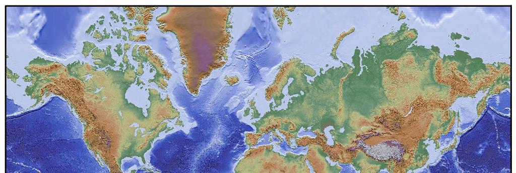
19 Global Topography


20 Normal foot of slope locations Software required Data quality

21 The Hedberg solution - foot of slope plus 60 nautical miles (Ireland: May 2005)


22 Difficult FOS location - NW Indian Ocean

23 Smoothly curving seafloor - absent/multiple FOS options
24 Evidence to the contrary - Paragraph 4b In the absence of evidence to the contrary, the foot of slope of the continental slope shall be determined as the point of maximum change of gradient at its base What is meant by evidence to the contrary? (CLCS 11, Section 6) Is it an exception to a general rule? (para 6.3.4, but ) How applicable is it to my margin?
25 Rifted volcanic and non-volcanic margins

26 Non-volcanic rifted margin - width of transition
27 Some of the options to locate the FOS by evidence to the contrary? Continent Ocean Transition Salt diapirism Tectonics at sheared or convergent margins Deformation fronts at leading edge of sediment loaded margins????
28 Constraints to claims - paragraph 5 The outer limits defined by the formulae lines shall not exceed either: 350M from the nearest point of the baseline 100M from the nearest point of the 2,500 meter depth contour Whichever is the greater
29 Extended Continental Shelf Constraints 350M 2500m+100M EEZ 200M FOS+60M 1% sediment thickness km Baseline Shelf Slope 2500m Foot of slope (FOS) 3 4 Rise Abyssal Plain


30 Special case for submarine ridges - paragraph 6 on submarine ridges, the outer limit of the continental shelf shall not exceed 350 nautical miles
31 Practical construction of an outer Formulae FOS plus 60 M limit FOS plus 1% sediment thickness Contraints 2500m plus 100 M 350 M
32 Coastal baselines 200M 200M Normal baseline
33 Seafloor morphology Foot of slope + 60M Foot of slope 2500m Water depth: 200m
34 Seafloor geology 1% sediment thickness Foot of slope
35 Art constraints 350M 2500m + 100M 200M 2500m
36 Extended CS 1% Final Final ECS ECS Claim Claim 350M 2500m + 100M 200M FOS + 60M

37 Potential Areas of Extended Continental Shelf
OUTER CONTINENTAL SHELF CLAIMS IN THE ARCTIC. Presentation given by Dr. Kamrul Hossain ASA University Bangladesh 15 March 2010
 OUTER CONTINENTAL SHELF CLAIMS IN THE ARCTIC Presentation given by Dr. Kamrul Hossain ASA University Bangladesh 15 March 2010 Contents Historical background of the continental shelf Concept of continental
FOOT OF THE CONTINENTAL SLOPE IN ARTICLE 76
 FOOT OF THE CONTINENTAL SLOPE IN ARTICLE 76 Vaughan Stagpoole, Institute of Geological & Nuclear Sciences, Lower Hutt, New Zealand, v.stagpoole@gns.cri.nz Ray Wood, Institute of Geological & Nuclear Sciences,
Article 76, variations in annotation and implementation seen in submission documents for the claim of Extended Continental Shelf
 Article 76, variations in annotation and implementation seen in submission documents for the claim of Extended Continental Shelf Mr. Shin Tani Chairman, IHO/IAG Advisory Board on the Law of the Sea (ABLOS)
EXECUTIVE SUMMARY A SUBMISSION OF DATA AND INFORMATION ON THE OUTER LIMITS OF THE CONTINENTAL SHELF OF THE REPUBLIC OF NIGERIA PURSUANT TO
 EXECUTIVE SUMMARY A SUBMISSION OF DATA AND INFORMATION ON THE OUTER LIMITS OF THE CONTINENTAL SHELF OF THE REPUBLIC OF NIGERIA PURSUANT TO PART VI OF AND ANNEX II TO THE UNITED NATIONS CONVENTION ON THE
CONFERENCE OF PARLIAMENTARIANS OF THE ARCTIC REGION. UN LOS Convention and the extended continental shelf in the Arctic
 CONFERENCE OF PARLIAMENTARIANS OF THE ARCTIC REGION UN LOS Convention and the extended continental shelf in the Arctic Presentation given by Dr. Kamrul Hossain Finnish Parliament 18 November 2009 Contents
Legal Interpretation of Submarine Ridges & Submarine Elevations
 Legal Interpretation of Ridges & Article 76, paragraph 6 New Knowledge and Changing Circumstances in the Law of the Sea Reykjavik, Iceland June 28, 2018 Kevin Baumert U.S. Department of State U.S. ECS
CONTINENTAL SHELF SUBMISSION OF ANGOLA - EXECUTIVE SUMMARY -
 CONTINENTAL SHELF SUBMISSION OF ANGOLA - EXECUTIVE SUMMARY - INDEX List of Figures 2 List of Tables 3 1 Introduction 5 2 Provisions of Article 76 7 3 Angolan Institutions responsible for the Submission
IRELAND. PART I Executive Summary
 IRELAND Submission to the Commission on the Limits of the Continental Shelf pursuant to Article 76, paragraph 8 of the United Nations Convention on the Law of the Sea 1982 in respect of the area abutting
Law of the Sea Symposium, February, 2016, TOKYO International Law for the Resources of the Sea
 Law of the Sea Symposium, 16-17 February, 2016, TOKYO International Law for the Resources of the Sea Segment 2 Governance of Resources of the Continental Shelf (including extended continental shelf) Introduction
Finding the continental shelf integration of geology and geophysics
 Finding the continental shelf integration of geology and geophysics R Wood Institute of Geological and Nuclear Sciences, PO Box 30-368, Lower Hutt, Telephone 64-4-570 4867, Fax 64-4-570 4803, Email r.wood@gns.cri.nz
EXECUTIVE SUMMARY A PARTIAL SUBMISSION OF DATA AND INFORMATION ON THE OUTER LIMITS OF THE CONTINENTAL SHELF OF THE KINGDOM OF TONGA PURSUANT TO
 EXECUTIVE SUMMARY A PARTIAL SUBMISSION OF DATA AND INFORMATION ON THE OUTER LIMITS OF THE CONTINENTAL SHELF OF THE KINGDOM OF TONGA PURSUANT TO PART VI OF AND ANNEX II TO THE UNITED NATIONS CONVENTION
The Relevance of Hydrography to UNCLOS; an Indonesian Perspective By: Prof. Dr. Hasjim Djalal, MA*
 The Relevance of Hydrography to UNCLOS; an Indonesian Perspective By: Prof. Dr. Hasjim Djalal, MA* As I understand it, the theme of this 6 th ABLOS Conference 2010 is Contentious Issues in UNCLOS- surely
Preliminary Information Indicative of the Outer Limits of the Continental Shelf Beyond 200 Nautical Miles of the People s Republic of China
 (Translation) Preliminary Information Indicative of the Outer Limits of the Continental Shelf Beyond 200 Nautical Miles of the People s Republic of China 1. The People s Republic of China ratified the
The french national programme for claiming continental shelf beyond 200 Miles
 The french national programme for claiming continental shelf beyond 200 Miles Using global bathymetric models in the context of an Extended Continental Shelf submission EXTRAPLAC Using Global Bathymetric
MAPS AND COORDINATES...
 Table of Contents 1 INTRODUCTION... 2 2 MAPS AND COORDINATES... 3 3 ADVISORY ASSISTANCE FROM COMMISSION MEMBERS... 3 4 PROVISIONS OF ARTICLE 76 INVOKED... 3 5 OUTSTANDING MARITIME DELIMITATIONS... 4 6
SOLVING THE RIDGES ENIGMA OF ARTICLE 76 OF THE UNITED NATIONS CONVENTION ON THE LAW OF THE SEA. Written by: George Taft Presented by: George Taft
 SOLVING THE RIDGES ENIGMA OF ARTICLE 76 OF THE UNITED NATIONS CONVENTION ON THE LAW OF THE SEA Written by: George Taft Presented by: George Taft (The views contained herein are those of the author and
Does Ascension Island have an outer continental shelf?
 Does Ascension Island have an outer continental shelf? Robin Cleverly UK Hydrographic Office Lindsay Parson NOC, Southampton (with Alan Evans, Peter Hunter, Rosemary Edwards of NOC and Chris Carleton of
ARTICLE 76: THE RIDGE ISSUE
 ARTICLE 76: THE RIDGE ISSUE by Alan EVANS 1, Chris CARLETON 2 and Lindsay PARSON 1 Address 1; Address 2; Southampton Oceanography Centre United Kingdom Hydrographic Office European Way Admiralty Way Southampton
Marine Science and Oceanography
 Marine Science and Oceanography Marine geology- study of the ocean floor Physical oceanography- study of waves, currents, and tides Marine biology study of nature and distribution of marine organisms Chemical
HOW TO DEFINE THE BASE OF THE SLOPE IN LOW GRADIENT PASSIVE MARGINS? BRAZILIAN CONTINENTAL SHELF PROJECT (LEPLAC)
") HOW TO DEFINE THE 1 BASE OF THE SLOPE IN LOW GRADIENT PASSIVE MARGINS? BRAZILIAN CONTINENTAL SHELF PROJECT (LEPLAC) Izabel King Jeck Commander, DHN, Brazilian Navy izabel@dhn.mar.mil.br How to apply art.76
HOW TO DEFINE THE 1 BASE OF THE SLOPE IN LOW GRADIENT PASSIVE MARGINS? BRAZILIAN CONTINENTAL SHELF PROJECT (LEPLAC) Izabel King Jeck Commander, DHN, Brazilian Navy izabel@dhn.mar.mil.br How to apply art.76
Earth s Continents and Seafloors. GEOL100 Physical Geology Ray Rector - Instructor
 Earth s Continents and Seafloors GEOL100 Physical Geology Ray Rector - Instructor OCEAN BASINS and CONTINENTAL PLATFORMS Key Concepts I. Earth s rocky surface covered by of two types of crust Dense, thin,
The Ocean Floor Earth Science, 13e Chapter 13
 The Ocean Floor Earth Science, 13e Chapter 13 Stanley C. Hatfield Southwestern Illinois College The vast world ocean Earth is often referred to as the blue planet Seventy-one percent of Earth s surface
Seas. A sea is a part of an ocean that is nearly surrounded by water. The Mediterranean, Arctic and Black Sea are really part of the Atlantic Ocean.
 Exploring the Ocean Since ancient times people have studied the ocean such as waters and ocean floor It provides food and services, and serves as a route for trade and travel The World s Oceans 71% of
Selection of Algorithms to Determine Foot of the Continental Slope to Delineate the Extended of the Continental Shelf
 Selection of Algorithms to Determine Foot of the Continental Slope to Delineate the Extended of the Continental Shelf Nawi ABDULLAH, Malaysia Key words: Geoinformation/GI; Hydrography; Legislation; Extended
Chapter 2. The Planet Oceanus
 Chapter 2 The Planet Oceanus Composition of the Earth The Earth consists of a series of concentric layers or spheres which differ in chemistry and physical properties. There are two different ways to describe
14.2 Ocean Floor Features Mapping the Ocean Floor
 14.2 Ocean Floor Features Mapping the Ocean Floor The ocean floor regions are the continental margins, the ocean basin floor, and the mid-ocean ridge. 14.2 Ocean Floor Features Continental Margins A continental
JOINT SUBMISSION TO THE COMMISSION ON THE LIMITS OF THE CONTINENTAL SHELF BY TUVALU, THE REPUBLIC OF FRANCE AND NEW ZEALAND (TOKELAU)
") JOINT SUBMISSION TO THE COMMISSION ON THE LIMITS OF THE CONTINENTAL SHELF BY TUVALU, THE REPUBLIC OF FRANCE AND NEW ZEALAND (TOKELAU) TABLE OF CONTENTS i. PREFACE... iii ii. LIST OF FIGURES... iv iii.
JOINT SUBMISSION TO THE COMMISSION ON THE LIMITS OF THE CONTINENTAL SHELF BY TUVALU, THE REPUBLIC OF FRANCE AND NEW ZEALAND (TOKELAU) TABLE OF CONTENTS i. PREFACE... iii ii. LIST OF FIGURES... iv iii.
MARINE GEOLOGY & GEOGRAPHY
 MARINE GEOLOGY & GEOGRAPHY Bathymetry BATHYMETRY BATHYMETRY THE UNDERWATER EQUIVALENT TO TOPOGRAPHY THE STUDY OF WATER DEPTH A BATHYMETRIC MAP SHOWS FLOOR RELIEF OR TERRAIN AS CONTOUR LINES Bathymetry
The Ocean Floor Chapter 14. Essentials of Geology, 8e. Stan Hatfield and Ken Pinzke Southwestern Illinois College
 The Ocean Floor Chapter 14 Essentials of Geology, 8e Stan Hatfield and Ken Pinzke Southwestern Illinois College The vast world ocean Earth is often referred to as the water planet 71% of Earth s surface
SIXTH REGULAR SESSION, 2017 C.B. NO A BILL FOR AN ACT
 NINETEENTH CONGRESS OF THE FEDERATED STATES OF MICRONESIA SIXTH REGULAR SESSION, 0 C.B. NO. - A BILL FOR AN ACT To amend title of the code of the Federated States of Micronesia by amending existing sections
OCEANOGRAPHY MEASURING THE DEPTHS OF THE OCEANS
 Water 2 page 1 OCEANOGRAPHY Name If all the water was drained from the ocean basins, what kind of surface would be revealed? It would not be the quiet, subdued topography as was once thought, but a surface
Clive Schofield * and David Freestone **
 Holding Back the Waves: Options to Secure Maritime Jurisdictional Claims in the Face of Sea Level Rise Clive Schofield * and David Freestone ** *Australian National Centre for Ocean Resources and Security
Earth / Environmental Science. Ch. 14 THE OCEAN FLOOR
 Earth / Environmental Science Ch. 14 THE OCEAN FLOOR The Blue Planet Nearly 70% of the Earth s surface is covered by the global ocean It was not until the 1800s that the ocean became an important focus
Small area of the ocean that is partially surrounded by land. The Ocean Basins. Three Major Oceans. Three Major Oceans. What is a SEA?
 The Ocean Basins How Deep is the Ocean? 1 2 Three Major Oceans Three Major Oceans Pacific Atlantic the shallowest ocean (3.3km average depth) Indian second shallowest ocean (3.8km average depth) Pacific
Oceanography, An Invitation to Marine Science 9e Tom Garrison. Ocean Basins Cengage Learning. All Rights Reserved.
 Oceanography, An Invitation to Marine Science 9e Tom Garrison 4 Ocean Basins Key Concepts Tectonic forces shape the seabed The ocean floor is divided into continental margins and deep ocean basins The
Geography of the world s oceans and major current systems. Lecture 2
 Geography of the world s oceans and major current systems Lecture 2 WHY is the GEOMORPHOLOGY OF THE OCEAN FLOOR important? (in the context of Oceanography) WHY is the GEOMORPHOLOGY OF THE OCEAN FLOOR important?
State Practice on the Establishment of Multiple Maritime Boundaries: Assessing the Challenges of Separating Seabed and Water Column Boundaries
 State Practice on the Establishment of Multiple Maritime Boundaries: Assessing the Challenges of Separating Seabed and Water Column Boundaries Professor Clive Schofield The Australian National Centre for
24. Ocean Basins p
 24. Ocean Basins p. 350-372 Background The majority of the planet is covered by ocean- about %. So the majority of the Earth s crust is. This crust is hidden from view beneath the water so it is not as
Sam Bateman and. State Practice Regarding Straight Baselines In East Asia Legal, Technical and Political Issues in a
 State Practice Regarding Straight Baselines In East Asia Legal, Technical and Political Issues in a Changing Environment Sam Bateman and Clive Schofield The Australian National Centre for Ocean Resources
The Continental Shelf Project: An overview of research activities in the Arctic Ocean on behalf of the Kingdom of Denmark
 The Continental Shelf Project: An overview of research activities in the Arctic Ocean on behalf of the Kingdom of Denmark Geological Survey of Denmark and Greenland Ministry of Climate and Energy John
ARTICLE I NATIONAL TERRITORY
 ARTICLE I NATIONAL TERRITORY The national territory comprises the Philippine archipelago, with all the islands and waters embraced therein, and all other territories over which the Philippines has sovereignty
Foundations of Earth Science, 6e Lutgens, Tarbuck, & Tasa
 Foundations of Earth Science, 6e Lutgens, Tarbuck, & Tasa Oceans: The Last Frontier Foundations, 6e - Chapter 9 Stan Hatfield Southwestern Illinois College The vast world ocean Earth is often referred
Lecture Outlines PowerPoint. Chapter 13 Earth Science 11e Tarbuck/Lutgens
 Lecture Outlines PowerPoint Chapter 13 Earth Science 11e Tarbuck/Lutgens 2006 Pearson Prentice Hall This work is protected by United States copyright laws and is provided solely for the use of instructors
REPUBLIC OF THE MARSHALL ISLANDS MARITIME ZONES DECLARATION ACT 2016.
 Republic of the Marshall Islands Maritime Zones Declaration Act 2016. 33MIRCCh.1Index TITLE 33 - MARINE ZONES AND PROTECTION OF MAMMALS CHAPTER 1 - MARITIME ZONE DECLARATION s Republic of the Marshall
Essential Question: How are the geological features that exist on land similar to the geological features on the ocean floor?
 Essential Question: How are the geological features that exist on land similar to the geological features on the ocean floor? Geography of the Oceans The world ocean can be divided into four main ocean
Map shows 3 main features of ocean floor
 Map shows 3 main features of ocean floor 2017 Pearson Education, Inc. Chapter 3 Marine Provinces 2017 Pearson Education, Inc. 1 Chapter 3 Overview The study of bathymetry determines ocean depths and ocean
Chapter Overview. Bathymetry. Measuring Bathymetry. Measuring Bathymetry
 CHAPTER 3 Marine Provinces Chapter Overview The study of bathymetry determines ocean depths and ocean floor topography. Echo sounding and satellites are efficient bathymetric tools. Most ocean floor features
Lecture 05: Ocean Basins. Hypsometric Curve. Consider Ocean Basins: What is the elevation of Chambana?
 Lecture 05: Ocean Basins 1 Hypsometric Curve What is the elevation of Chambana? Shows distribution of surface relative to sea level ~67% below sea level Mean ocean depth ~ -3.7 km (well below sea level)
Ocean Basins, Bathymetry and Sea Levels
 Ocean Basins, Bathymetry and Sea Levels Chapter 4 Please read chapter 5: sediments for next class and start chapter 6 on seawater for Thursday Basic concepts in Chapter 4 Bathymetry the measurement of
MARINE GEOLOGY & GEOGRAPHY
 MARINE GEOLOGY MARINE GEOLOGY & GEOGRAPHY Marine Geology 4 LAYERS OF THE EARTH CRUST THICKNESS: VARIES BETWEEN OCEAN & CONTINENTS 5-40 KM STATE: SOLID ELEMENTS: SILICON, ALUMINUM, CALCIUM, SODIUM, POTASSIUM
Chapter Introduction Lesson 1 The Continental Drift Hypothesis Lesson 2 Development of a Theory Lesson 3 The Theory of Plate Tectonics Chapter
 Chapter Introduction Lesson 1 The Continental Drift Hypothesis Lesson 2 Development of a Theory Lesson 3 The Theory of Plate Tectonics Chapter Wrap-Up Arctic_Images/Getty Images What is the theory of plate
Bathymetry Measures the vertical distance from the ocean surface to mountains, valleys, plains, and other sea floor features
 1 2 3 4 5 6 7 8 9 10 11 CHAPTER 3 Marine Provinces Chapter Overview The study of bathymetry determines ocean depths and ocean floor topography. Echo sounding and satellites are efficient bathymetric tools.
GeomaticsWorld. Issue No 3 : Volume 21. Helping to unravel Easter Island s mysterious statues. DGI 2013: maritime security highlighted
 GeomaticsWorld MARCH APRIL 2013 Issue No 3 : Volume 21 BIM: repeat the message even if you lose the will to live Helping to unravel Easter Island s mysterious statues DGI 2013: maritime security highlighted
Chapter 9 Lecture Outline. Oceans: The Last Frontier
 Chapter 9 Lecture Outline Oceans: The Last Frontier The Vast World Ocean Earth is referred to as the blue planet 71% of Earth s surface is oceans and marginal seas Continents and islands comprise the remaining
ANALYSIS OF CLCS RECOMMENDATIONS IN LIGHT OF THEIR RELEVANCE TO THE DELINEATION OF A UNITED STATES EXTENDED CONTINENTAL SHELF (ECS) IN THE ARCTIC
 IN THE ARCTIC") ANALYSIS OF CLCS RECOMMENDATIONS IN LIGHT OF THEIR RELEVANCE TO THE DELINEATION OF A UNITED STATES EXTENDED CONTINENTAL SHELF (ECS) IN THE ARCTIC BY ONNI BOWEN IRISH Bachelor of Science in Foreign Service
ANALYSIS OF CLCS RECOMMENDATIONS IN LIGHT OF THEIR RELEVANCE TO THE DELINEATION OF A UNITED STATES EXTENDED CONTINENTAL SHELF (ECS) IN THE ARCTIC BY ONNI BOWEN IRISH Bachelor of Science in Foreign Service
Outer Continental Shelf
 The Delimitation of the Outer Continental Shelf Presentation by Stephen Fietta Monaco, 17 October 2008 Latham & Watkins is the business name of Latham & Watkins (London) LLP, a registered limited liability
MULTIPLE CHOICE. Choose the one alternative that best completes the statement or answers the question.
 Geology 300, Physical Geology Spring 2019 Quiz Chapter 18, Seafloor Name MULTIPLE CHOICE. Choose the one alternative that best completes the statement or answers the question. 1) Abyssal fans are made
Marine Geospatial Software: Generating Economic Benefits from Hydrographic Data and Calculation of Maritime Boundaries
 Marine Geospatial Software: Generating Economic Benefits from Hydrographic Data and Calculation of Serge LEVESQUE and Alexis CARDENAS, Canada Key words: marine geospatial data, hydrography, economic benefits,
Draft Presentation Carleton Conference on the Arctic Is There a Need for New Legal Regime in the Arctic?
 Draft Presentation Carleton Conference on the Arctic Is There a Need for New Legal Regime in the Arctic? Donald McRae, University of Ottawa The climatic changes affecting the Arctic have lead to visions
Moving Plates: Restless Earth
 Name Date Moving Plates: Restless Earth 1-9 Read the paragraphs and write the word that completes the sentence correctly. fossils mantle continent supercontinent plates motion ontinental Drift Plate Tectonics
Seafloor Morphology. Techniques of Investigation. Bathymetry and Sediment Studies
 Seafloor Morphology I f we select a grid for the surface of the earth (i.e. 5 km 2 ) and assign it an average elevation in relation to sea level, we can construct a graph of elevation versus area of the
PRELIMINARY INFORMATION
 PRELIMINARY INFORMATION INDICATIVE OF THE OUTER LIMITS OF THE CONTINENTAL SHELF AND DESCRIPTION OF THE STATUS OF PREPARATION OF MAKING A SUBMISSION TO THE COMMISSION ON THE LIMITS OF THE CONTINENTAL SHELF
How to Deal with Maritime Boundary Uncertainty in Oil and Gas Exploration and Production Areas*
 The University of Texas School of Law Presented: International Upstream Energy Transactions January 17-18, 2013 Houston, TX How to Deal with Maritime Boundary Uncertainty in Oil and Gas Exploration and
Sea-Floor Spreading, Subduction,& Plate Boundaries. Lecture Continental Fit 2. Similar Rocks, Ages 3. Similar Fossils 4. Widespread Glaciation
 Sea-Floor Spreading, Subduction,& Plate Boundaries Lecture 21 Prop: Test 3 Invitations Alfred Wegener s Evidence for Continental Drift 1. Continental Fit 2. Similar Rocks, Ages 3. Similar Fossils 4. Widespread
Unit 1: Water Systems on Earth Chapter 2
 Unit 1: Water Systems on Earth Chapter 2 Create a mind map with the driving question, Why are Oceans Important? Remember: Why are oceans so important? Why are oceans so important? Primary water source
Shape of the seafloor. Shape of the seafloor. Shape of the seafloor. Shape of the seafloor. Shape of the seafloor. Shape of the seafloor
 Multibeam echo sounders - Research vessel Scripps Institution of Oceanography R/V Roger Revelle depth Source: Scripps Institution of Oceanography http://woodshole.er.usgs.gov/project-pages/caribbean/movie1.html
Seafloor Mapping in the High Arctic: The Challenges and the Joys
 Seafloor Mapping in the High Arctic: The Challenges and the Joys Larry Mayer Center for Coastal and Ocean Mapping / NOAA- UNH Joint Hydrographic Center University of New Hampshire, USA Martin Jakobsson
Earth s Structure and Surface
 Earth s Structure and Surface Structure of the Earth The earth is thought have originated about 4.5 billion years ago from a cloud or clouds of dust. The dust was the remains of a huge cosmic explosion
BRAZILIAN SOUTHERN MARGIN: AN EXAMPLE OF THE IDENTIFICATION OF THE BASE OF THE SLOPE ON A PASSIVE CONTINENTAL MARGIN
 BRAZILIAN SOUTHERN MARGIN: AN EXAMPLE OF THE IDENTIFICATION OF THE BASE OF THE SLOPE ON A PASSIVE CONTINENTAL MARGIN Luiz Carlos Torres Brazilian Navy Hydrographic Center Izabel King Jeck Brazilian Navy
Chapter 2 Plate Tectonics and the Ocean Floor
 Chapter 2 Plate Tectonics and the Ocean Floor Matching. Match the term or person with the appropriate phrase. You may use each answer once, more than once or not at all. 1. hydrothermal vents A. convergent
Plate Tectonics: A Unifying Theory
 Plate Tectonics: A Unifying Theory What is Plate Tectonics? - 7 large tectonic plates and many smaller ones that break up the lithosphere - Plates are brittle and float on asthenosphere and glide past
Non-living Resources of the OCS. Harald Brekke NPD
 Non-living Resources of the OCS Harald Brekke NPD The Continental Shelf and the Area http://www.grida.no/publications/shelf-last-zone/ Outer Continental Shelf Example http://www.grida.no/publications/shelf-last-zone/
Lecture 26: Marine Geology Read: Chapter 21 Homework due December 3
 Learning Objectives (LO) Lecture 26: Marine Geology Read: Chapter 21 Homework due December 3 What we ll learn today:! 1. Describe the world s five oceans! 2. Understand patterns of ocean circulation! 3.
OCN 201 Physiography of the Seafloor
 OCN 201 Physiography of the Seafloor Hypsometric Curve for Earth s solid surface Note histogram Hypsometric curve of Earth shows two modes. Hypsometric curve of Venus shows only one! Why? Ocean Depth vs.
FINDING THE CONTINENTAL SHELF EXAMPLES FROM THE NEW ZEALAND REGION
 FINDING THE CONTINENTAL SHELF EXAMPLES FROM THE NEW ZEALAND REGION ABSTRACT New Zealand has nearly completed the surveying phase of its Continental Shelf Project. Some surveys have been designed to fill
UNIT 3 GEOLOGY VOCABULARY FLASHCARDS THESE KEY VOCABULARY WORDS AND PHRASES APPEAR ON THE UNIT 3 CBA
 UNIT 3 GEOLOGY VOCABULARY FLASHCARDS THESE KEY VOCABULARY WORDS AND PHRASES APPEAR ON THE UNIT 3 CBA A map that shows Earth s Topographic Map surface topography, which is Earth s shape and features Contour
The Southern Continental Shelf of Greenland
 Partial Submission of the Government of the Kingdom of Denmark together with the Government of Greenland to the Commission on the Limits of the Continental Shelf The Southern Continental Shelf of Greenland
Unit 4 - Water. Earth s Interior. Earth s Interior. Continental Drift. Continental Drift. Continental Drift. Crust. Mantle. Core.
 Unit 4 - Water How did the oceans form? What special adaptations do saltwater organisms have? Where does our water come from? How do humans affect the Earth s water? Crust Rigid outer shell of Earth Oceanic
The surface of the ocean floor is as varied as the land. The five major oceans, from largest to smallest, are
 11.1 Ocean Basins The surface of the ocean floor is as varied as the land. The five major oceans, from largest to smallest, are w the Pacific w the Atlantic w the Indian w the Southern w the Arctic The
CX Debate Topic Analysis
 CX Debate Topic Analysis Larry McCarty lmac916@gmail.com or larry.mc@excite.com Resolved: The United States federal government should substantially increase its nonmilitary exploration and/or development
Earth overall average density = 5.5 g/cm 3 Temp increases with depth, the thermal gradient 30 0 C/km Pressure and the density also increase with
 Plate Tectonics Earth Earth overall average density = 5.5 g/cm 3 Temp increases with depth, the thermal gradient 30 0 C/km Pressure and the density also increase with depth Spheroid: with a longer major
Sea-Floor Spreading, Subduction,& Plate Boundaries. Lecture 23. Geol 101 (Kite) Quiz 9, April Geol 101 (Kite) Quiz 9, April 2006
 Quiz 9, April Geol 101 (Kite) Quiz 9, April 2006") Sea-Floor Spreading, Subduction,& Plate Boundaries Lecture 23 Prop: Test 3 Invitations Geol 101 (Kite) Quiz 9, April 2005 ******************************* * You are cordially invited * Name * to attend
Sea-Floor Spreading, Subduction,& Plate Boundaries Lecture 23 Prop: Test 3 Invitations Geol 101 (Kite) Quiz 9, April 2005 ******************************* * You are cordially invited * Name * to attend
8 th Grade Science Plate Tectonics and Topography Review
 8 th Grade Science Plate Tectonics and Topography Review #1 Scientists believe that the land masses of Earth were once joined together as one supercontinent called. A: Australia B: Wegner C: Pangaea D:
Preliminary Information Indicative of the outer limits of the continental shelf And Description of the status of preparation of making a submission
 Preliminary Information Indicative of the outer limits of the continental shelf And Description of the status of preparation of making a submission To the Commission on the Limits of the Continental Shelf
The Continental Shelf North of the Faroe Islands
 Partial Submission of the Government of the Kingdom of Denmark together with the Government of the Faroes to the Commission on the Limits of the Continental Shelf The Continental Shelf North of the Faroe
A new method to identify the foot of continental slope based on an integrated profile analysis
 Mar Geophys Res (2017) 38:199 207 DOI 10.1007/s11001-016-9273-4 ORIGINAL RESEARCH PAPER A new method to identify the foot of continental slope based on an integrated profile analysis Ziyin Wu 1,2 Jiabiao
1. I can describe evidence for continental drift theory (e.g., fossil evidence, mountain belts, paleoglaciation)
") Science 10 Review Earth Science Vocabulary asthenosphere continental drift theory converging plates diverging plates earthquakes epicentre fault hot spot inner core lithosphere mantle mantle convection
Science 10 Review Earth Science Vocabulary asthenosphere continental drift theory converging plates diverging plates earthquakes epicentre fault hot spot inner core lithosphere mantle mantle convection
Full file at
 Essentials of Oceanography, 10e (Trujillo/Keller) Chapter 2 Plate Tectonics and the Ocean Floor Match the term with the appropriate phrase. You may use each answer once, more than once or not at all. A)
Geological features and geophysical signatures of continental margins of India
 Geological features and geophysical signatures of continental margins of India K. S. Krishna National Institute of Oceanography, Dona Paula, Goa-43 4. krishna@nio.org The shape and classification of continental
Introduction to Acoustic Remote Sensing and Seafloor Mapping (AE4-E13) May 19, 2010
 May 19, 2010") Introduction to Acoustic Remote Sensing and Seafloor Mapping (AE4-E13) May 19, 2010 1 Delft Vermelding Institute onderdeel of Earth organisatie Observation and Space Systems Why Acoustic Remote Sensing?
Introduction to Acoustic Remote Sensing and Seafloor Mapping (AE4-E13) May 19, 2010 1 Delft Vermelding Institute onderdeel of Earth organisatie Observation and Space Systems Why Acoustic Remote Sensing?
Plate Tectonics. Development of a Theory
 CHAPTER 7 LESSON 2 Plate Tectonics Development of a Theory Key Concepts What is seafloor spreading? What evidence is used to support seafloor spreading? What do you think? Read the two statements below
xxv PART I THE DIVIDED OCEANS: INTERNATIONAL LAW GOVERNING JURISDICTIONAL ZONES 1
 Contents Preface page xv List of Figures xvii List of Tables xviii List of Abbreviations xix Table of Cases xxi Table of Treaties and Instruments xxv PART I THE DIVIDED OCEANS: INTERNATIONAL LAW GOVERNING
12/3/2014. Plate Tectonics: A Scientific Revolution Unfolds Earth Science, 13e Chapter 7. Continental drift: an idea before its time
 Plate Tectonics: A Scientific Revolution Unfolds Earth Science, 13e Chapter 7 Stanley C. Hatfield Southwestern Illinois College Continental drift: an idea before its time Alfred Wegener First proposed
1. Name at least one place that the mid-atlantic Ridge is exposed above sea level.
 Interpreting Tectonic and Bathymetric Maps. The purpose of this lab is to provide experience interpreting the bathymetry of the seafloor in terms of tectonic and geologic settings and processes. Use the
A scientific challenge to the delineation of Japan s continental shelf
 Research paper A scientific challenge to the delineation of Japan s continental shelf - Contribution to validating the Japan s rights over marine areas based on earth science- Akira Nishimura * 1, Makoto
Plate Tectonics 3. Where Does All the Extra Crust Go?
 Plate Tectonics 3 Where Does All the Extra Crust Go? Unless otherwise noted the artwork and photographs in this slide show are original and by Burt Carter. Permission is granted to use them for non-commercial,
OCN 201 Physiography of the Seafloor
 OCN 201 Physiography of the Seafloor 1 Ocean Depth versus Continental Height Why do we have dry land? Solid surface of Earth is dominated by two levels: Land with a mean elevation of +840 m (29% of Earth
Non-Living Ocean Resources
 Cover Story 2 Non-Living Ocean Resources Introduction Two thirds (2/3) of the surface of the earth is covered by oceans. Resources from the oceans are essential to meet daily needs of mankind. Ocean resources
Captain J. Ashley Roach, JAGC, USN (retired) Office of the Legal Adviser U.S. Department of State (retired) Visiting Senior Principal Research Fellow
 Office of the Legal Adviser U.S. Department of State (retired) Visiting Senior Principal Research Fellow") Captain J. Ashley Roach, JAGC, USN (retired) Office of the Legal Adviser U.S. Department of State (retired) Visiting Senior Principal Research Fellow Centre for International Law NUS Singapore SCS Award
Captain J. Ashley Roach, JAGC, USN (retired) Office of the Legal Adviser U.S. Department of State (retired) Visiting Senior Principal Research Fellow Centre for International Law NUS Singapore SCS Award
Ch 9.1 Notes. Objective: Be able to explain the theory of plate tectonics and be able to explain evidence that supports it.
 Ch 9.1 Notes Objective: Be able to explain the theory of plate tectonics and be able to explain evidence that supports it. Pangaea Alfred Wegener proposed that land on Earth formed a single, huge landmass.