Non-living Resources of the OCS. Harald Brekke NPD
|
|
|
- James Hart
- 5 years ago
- Views:
Transcription

1 Non-living Resources of the OCS Harald Brekke NPD

2 The Continental Shelf and the Area
3 Outer Continental Shelf Example
 Hydrocarbon")
4 Norwegian Continental Shelf (NOCS) Hydrocarbon Management


5 Geographical Location Arctic Ocean Svalbard Barents Sea Jan Mayen Faroe Islands 5
6 NE Atlantic Overview 6
7 Barents Sea NOCS Structure map Norwegian Sea North Sea
8 General Stratigraphy
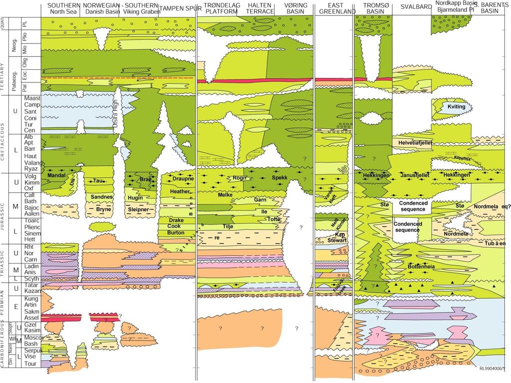
9 Main Prospective Level
10 The Platform Margin
11 Barents Sea NOCS Structure map Norwegian Sea North Sea

12 Barents Sea Shelf Profile
13 The Rifted, Volcanic Margin

14 Barents Sea NOCS Structure map Norwegian Sea North Sea

15 Regional Geoseismic Sections Vøring Basin

16 Vøring Basin Trødelag Platform

17 Sills and Inner Flows
18 Fracture Zone Ridge

19 Seismic Line LOS S N Vøring Spur

20 Sediment rich Abyssal Plain

21 Seismic Line LOS NW SE
22 The Microcontinent Margin
23 Jan Mayen Microcontinent but I shall contact him on Monday 23


24 Jan Mayen Microcontinent but I shall contact him on Monday 24


25 Palinspastic Crustal Transects 25 Ma Present Mjelde et al. 2008

26 Jan Mayen Tectonics Courtesy of Orkustofnun
27 Resource assessment
28 Play Model A population of discoveries and prospects that share the same critical, geological factors: Reservoir rock (age and type) Trap mechanism (tectonic, stratigraphic) Source (source rock, maturity, migration)
29 Reservoir
30 Trap
31 Source
32 Play model
33 Play model and mapped prospects
34 Statistical Play Assessment Prospect model Reservoir parameters Liquid parameters Recovery factor Prospect number distribution Area covered Prospect density Prospect size distribution Mapped prospects Minimum and maximum size estimates Risk assessment Prospect level Play model level

35 1971: Brent Oil Field Discovery FINLAND SWEDEN BRENT Balder Ekofisk Groningen Nordisk Geologisk Vintermøte Uppsala 2004

36 Brent Play Model Reservoir: Middle Jurassic sandstone Trap: Rotated fault block Source: Upper Jurassic black shales

37 Brent Play Norwegian North Sea Oil Fields Gas Fields

38 Barents Sea Extrapolation of the Brent Play on the Norwegian Sea NCS North Sea Nordisk Geologisk Vintermøte Uppsala 2004
 Recoverable HC")
39 Norwegian Continental Shelf (NOCS) Recoverable HC Resources
40 Undiscovered Resources

41 Confirmed and unconfirmed plays

42 Number of Plays
43 Hydrocarbon Resources Beyond 200 M
44 Limits and lines associated with NOCS
45 NOCS
46 HC Beyond 200 M
47 HC Beyond 200 M

48 Eocene Lava Play
49 Pre-Palaeocene Sandstones Play
50 Plays straddling 200 M limit line
51 Size of Plays, Norwegian Sea
52 Seabed Mineral Resources, NOCS


53 Active and Extinct Vent fields at the Arctic Mid-Ocean Ridge Hydrothermal plume Sulfide deposit Extinct field Active field Pedersen et al Courtesy of R. B. Pedersen, Univ of Bergen
54 Active fields and OCS
55 Active fields and OCS


56 The Jan Mayen Vent Field Area Courtesy of R. B. Pedersen, Univ of Bergen

57 The Troll Wall Vent Field Courtesy of R. B. Pedersen, Univ of Bergen

58 The Soria Moria Vent Field Located on a Volcanic Ridge 100m Courtesy of R. B. Pedersen, Univ of Bergen

59 Neovolcanic zone and off-axis areas 75 m grid Central Mohns Ridge 10km

60 Active fields and OCS


61 Burial of Ridge Flank and Rift Valley by The Bear Island Fan 50km Courtesy of R. B. Pedersen, Univ of Bergen

62 Location of the Loki s Castle Vent Field Courtesy of R. B. Pedersen, Univ of Bergen 7 00E 7 30E 8 00E 8 30E 9 00E Core complexes Mohn s Treasure Loki s Castle 600 m Bear Island Fan Figure 7 Sulphide layer in sediment core 10 km 3500 m


63 Loki s Castle - Relations to Volcanic & Structural Elements 3300 m Bear Island Fan Faulted Terrain Developing Core Complex? 1800 m young volcanic flows Loki s Castle Rift 2010 m Axial Volcanic Ridge N 1km Courtesy of R. B. Pedersen, Univ of Bergen


64 AUV survey 2010 N Loki s Castle Kongsberg Hugin EM m grid Courtesy of R. B. Pedersen, Univ of Bergen 1 km


65 Microbathymetry of the Loki s Castle Vent Field Hydrothermal mineral deposit High temperature vent sites 100 m Courtesy of R. B. Pedersen, Univ of Bergen


66 Chimneys & Hydrothermal Deposits 13 m Courtesy of R. B. Pedersen, Univ of Bergen

67 Loki s Castle Hydrothermal Mound Courtesy of R. B. Pedersen, Univ of Bergen


68 Comparison with the TAG Hydrothermal Mound TAG Loki s Castle Courtesy of R. B. Pedersen, Univ of Bergen TAG 100 m Loki s Castle

69 Estimated Tonnage Coverage: m 2 Max Height: m Tonnage: 1-2 Mt Courtesy of R. B. Pedersen, Univ of Bergen 100 m


 deposits Basalt")
70 Seafloor Massive Sulfide Deposits Norwegian Continental Shelf Sediment & basalt hosted deposits Courtesy of R. B. Pedersen, Univ of Bergen Basalt hosted Zn (Au) deposits Basalt hosted Cu-Zn deposits

71 Global Neovolcanic Zone
72 Total Amount of Cu-Zn along the Neovolcanic Zone of the Global Ridge System 1000 deposits minimum size of 100 t maximum size of 1x10 7 t Total amount of massive sulfide estimated to 6x10 8 t Median grade of 5 wt% Cu+Zn Total amount Cu+Zn estimated to be 3x10 7 t Hannington et al. 2011, Geology Courtesy of R. B. Pedersen, Univ of Bergen
73 Estimated amounts of Cu-Zn along the Neovolcanic zone of the Norwegian Ridge System The total amount Cu+Zn is estimated to be on the order of 3x10 7 t Approximately 90% of this is at slow spreading ridges The global ridge system is km long of which 55-60% is spreading at a slow rate The ridges within the Norwegian CS is around 1300 km, which represent 3% of the slow spreading ridges The amount of Cu-Zn along the neovolcanic part of the Norwegian ridges is estimated to be on the order of 1x10 6 t (No good model for development of flanking core complexes as yet) Based on Hannington et al Courtesy of R. B. Pedersen, Univ of Bergen
74 Deep Sea Geotopes, NOCS
75 Sediment fans
76 Ocean Spreading Ridges
77 Magma-influenced Continental Crust
78 Fracture Zone Ridges and Seamounts

79 Seabed Geotopes
80 Geotopes and Resource Distribution A Tentative Approach
81 Geotopes and Resource Deposits Shelf Plateaus Magmatically influenced CC Sediment fans Volcanic Arcs Spreading ridges Fracture Zones, Seamounts Magmatic Plateaus (LIPs) Abyssal Plains, Low-sed Abyssal Plains, High-sed HC HC, FMC, (SMS) HC, (SMS?) SMS SMS FMC SMS?, PMN? PMN? (HC?)
82 Geotope Features as Basis for Outer Limits Shelf Plateaus Magmatically influenced CC Sediment fans Volcanic Arcs Spreading ridges Fracture Zones, Seamounts Magmatic Plateaus (LIPs) Abyssal Plains, Low-sed Abyssal Plains, High-sed HC HC, FMC, (SMS) HC, (SMS?) SMS SMS FMC SMS?, PMN? PMN? (HC?)

83 Areas of the current submissions 83
84 Geological Features in OCS Features No of Submissions Considered by CLCS Recomm Not Recom Included in OCS so far Shelf plateaus Magmatically influenced continental crust features Sediment fans, wedges Volcanic Arcs Spreading ridges Spreading ridges, anomalous Fracture Zones, seamounts Magmatic plateaus (incl. LIPs)
85 Shelf Plateaus
86 Magmatically influenced CC features
87 Fracture Zones, Seamounts
88 Sediment Fans and Wedges
89 Volcanic Arcs
90 Spreading Ridges
91 Anomalous Spreading Ridges
92 Magmatic Plateaus

93 Seabed Jurisdiction The Area 53 % EEZ 39 % OCS submissions 7 % OCS in PIDs 1 %
94 Summary Most frequent features submitted for Shelf plateau areas Magmatically influenced continental crust features Fracture zones and seamounts Sediment fans and wedges Low expectations for HC resources in OCS, except on some large continental plateaus Geotopes included in submissions are probably mostly in favour of FMC, less of SMS, and least of PMN Acreage under current submissions for OCS amounts to 7-8 % of total seabed
Play fairway mapping in the Northeast Atlantic Margin Comparison between mature and immature basins. David Mudge, Joanne Cranswick
 Play fairway mapping in the Northeast Atlantic Margin Comparison between mature and immature basins David Mudge, Joanne Cranswick Contents Ternan North Sea Play fairway mapping Tertiary case study Northeast
Earth s Continents and Seafloors. GEOL100 Physical Geology Ray Rector - Instructor
 Earth s Continents and Seafloors GEOL100 Physical Geology Ray Rector - Instructor OCEAN BASINS and CONTINENTAL PLATFORMS Key Concepts I. Earth s rocky surface covered by of two types of crust Dense, thin,
Marine Science and Oceanography
 Marine Science and Oceanography Marine geology- study of the ocean floor Physical oceanography- study of waves, currents, and tides Marine biology study of nature and distribution of marine organisms Chemical
JMRS11 Jan Mayen Ridge Sampling Survey 2011
 JMRS11 Jan Mayen Ridge Sampling Survey 2011 JMRS11 Report Presentation VBPR/TGS, February 2012 Confidentiality Screen dumps and the underlying data in this document are confidential and proprietary to
Oceanography, An Invitation to Marine Science 9e Tom Garrison. Ocean Basins Cengage Learning. All Rights Reserved.
 Oceanography, An Invitation to Marine Science 9e Tom Garrison 4 Ocean Basins Key Concepts Tectonic forces shape the seabed The ocean floor is divided into continental margins and deep ocean basins The
Prospects and Status of Exploration for Polymetallic Sulphides. Georgy Cherkashov VNIIOkeangeologia St.Petersburg, RUSSIA
 Prospects and Status of Exploration for Polymetallic Sulphides Georgy Cherkashov VNIIOkeangeologia St.Petersburg, RUSSIA Introduction Outline Hydrothermal processes and seafloor massive sulfides (SMS):
Geology & Geophysics Applied in Industry. EXERCISE 2: A Quick-Look Evaluation
 EXERCISE 2: A Quick-Look Evaluation You have been asked to perform a quick back-of-the-envelope evaluation of the blocks being offered off of Somewhereia. Is there enough potential that our company should
Ocean Basins, Bathymetry and Sea Levels
 Ocean Basins, Bathymetry and Sea Levels Chapter 4 Please read chapter 5: sediments for next class and start chapter 6 on seawater for Thursday Basic concepts in Chapter 4 Bathymetry the measurement of
Geography of the world s oceans and major current systems. Lecture 2
 Geography of the world s oceans and major current systems Lecture 2 WHY is the GEOMORPHOLOGY OF THE OCEAN FLOOR important? (in the context of Oceanography) WHY is the GEOMORPHOLOGY OF THE OCEAN FLOOR important?
Map shows 3 main features of ocean floor
 Map shows 3 main features of ocean floor 2017 Pearson Education, Inc. Chapter 3 Marine Provinces 2017 Pearson Education, Inc. 1 Chapter 3 Overview The study of bathymetry determines ocean depths and ocean
MARINE GEOLOGY & GEOGRAPHY
 MARINE GEOLOGY MARINE GEOLOGY & GEOGRAPHY Marine Geology 4 LAYERS OF THE EARTH CRUST THICKNESS: VARIES BETWEEN OCEAN & CONTINENTS 5-40 KM STATE: SOLID ELEMENTS: SILICON, ALUMINUM, CALCIUM, SODIUM, POTASSIUM
Deep-Sea and Sub-Seafloor Resources: A Polymetallic Sulphide and Co-Mn Crust Perspective. Stephen Roberts
 Deep-Sea and Sub-Seafloor Resources: A Polymetallic Sulphide and Co-Mn Crust Perspective by Stephen Roberts The LRET Research Collegium Southampton, 16 July 7 September 2012 1 Deep-Sea and Sub-Seafloor
The Sea Floor. Chapter 2
 The Sea Floor Chapter 2 Geography of the Ocean Basins World ocean is the predominant feature on the Earth in total area Northern Hemisphere = 61% of the total area is ocean. Southern Hemisphere = about
OCN 201 Physiography of the Seafloor
 OCN 201 Physiography of the Seafloor Hypsometric Curve for Earth s solid surface Note histogram Hypsometric curve of Earth shows two modes. Hypsometric curve of Venus shows only one! Why? Ocean Depth vs.
14.2 Ocean Floor Features Mapping the Ocean Floor
 14.2 Ocean Floor Features Mapping the Ocean Floor The ocean floor regions are the continental margins, the ocean basin floor, and the mid-ocean ridge. 14.2 Ocean Floor Features Continental Margins A continental
Lecture Marine Provinces
 Lecture Marine Provinces Measuring bathymetry Ocean depths and topography of ocean floor Sounding Rope/wire with heavy weight Known as lead lining Echo sounding Reflection of sound signals 1925 German
Chapter Overview. Bathymetry. Measuring Bathymetry. Measuring Bathymetry
 CHAPTER 3 Marine Provinces Chapter Overview The study of bathymetry determines ocean depths and ocean floor topography. Echo sounding and satellites are efficient bathymetric tools. Most ocean floor features
Unit 6: The Sea Floor
 Unit 6: The Sea Floor Turn to Page 62 in Introduction to the World s Oceans Study the bathymetric chart What features do you see? How do the Atlantic and Pacific Oceans differ? What do you think accounts
Structure of the Earth
 Structure of the Earth Compositional (Chemical) Layers Crust: Low density Moho: Density boundary between crust and mantle Mantle: Higher density High in Magnesium (Mg) and Iron (Fe) Core: High in Nickel
History of geology and research of the Jan Mayen Micro-Continent and its associated exploration risks.
 History of geology and research of the Jan Mayen Micro-Continent and its associated exploration risks. Anett Blischke, Iceland GeoSurvey Þórarinn S. Arnarson, Karl Gunnarsson, Iceland GeoSurvey The North-Dreki
Shape of the seafloor. Shape of the seafloor. Shape of the seafloor. Shape of the seafloor. Shape of the seafloor. Shape of the seafloor
 Multibeam echo sounders - Research vessel Scripps Institution of Oceanography R/V Roger Revelle depth Source: Scripps Institution of Oceanography http://woodshole.er.usgs.gov/project-pages/caribbean/movie1.html
Chapter 2 Plate Tectonics and the Ocean Floor
 Chapter 2 Plate Tectonics and the Ocean Floor Matching. Match the term or person with the appropriate phrase. You may use each answer once, more than once or not at all. 1. hydrothermal vents A. convergent
24. Ocean Basins p
 24. Ocean Basins p. 350-372 Background The majority of the planet is covered by ocean- about %. So the majority of the Earth s crust is. This crust is hidden from view beneath the water so it is not as
MUHAMMAD S TAMANNAI, DOUGLAS WINSTONE, IAN DEIGHTON & PETER CONN, TGS Nopec Geological Products and Services, London, United Kingdom
 Geological and Geophysical Evaluation of Offshore Morondava Frontier Basin based on Satellite Gravity, Well and regional 2D Seismic Data Interpretation MUHAMMAD S TAMANNAI, DOUGLAS WINSTONE, IAN DEIGHTON
Bathymetry Measures the vertical distance from the ocean surface to mountains, valleys, plains, and other sea floor features
 1 2 3 4 5 6 7 8 9 10 11 CHAPTER 3 Marine Provinces Chapter Overview The study of bathymetry determines ocean depths and ocean floor topography. Echo sounding and satellites are efficient bathymetric tools.
The Ocean Floor Earth Science, 13e Chapter 13
 The Ocean Floor Earth Science, 13e Chapter 13 Stanley C. Hatfield Southwestern Illinois College The vast world ocean Earth is often referred to as the blue planet Seventy-one percent of Earth s surface
Plate Tectonics. I. The Discovery of Plate Tectonics II. A Mosaic of Plates III. Types of Plate Boundaries IV. How Plates Move
 Plate Tectonics I. The Discovery of Plate Tectonics II. A Mosaic of Plates III. Types of Plate Boundaries IV. How Plates Move I. The Discovery of Plate Tectonics A. Continental Drift (Alfred Wegener) Proposed
The interconnected uplift history and structural development of the Jan Mayen Micro-Continent and Iceland during the Cenozoic.
 The interconnected uplift history and structural development of the Jan Mayen Micro-Continent and Iceland during the Cenozoic. Anett Blischke, Iceland GeoSurvey Þórarinn S. Arnarson, of Iceland Bryndis
Full file at
 Essentials of Oceanography, 10e (Trujillo/Keller) Chapter 2 Plate Tectonics and the Ocean Floor Match the term with the appropriate phrase. You may use each answer once, more than once or not at all. A)
Key Elements of the Petroleum Systems of the Rockall and Slyne-Erris Basins
 Key Elements of the Petroleum Systems of the Rockall and Slyne-Erris Basins Bandon Corrib Dooish Atlantic Ireland Conference, Dublin, 1 st - 2 nd November 2016 Rockall and Slyne-Erris Basins Only 11 exploration
MULTIPLE CHOICE. Choose the one alternative that best completes the statement or answers the question.
 Geology 300, Physical Geology Spring 2019 Quiz Chapter 18, Seafloor Name MULTIPLE CHOICE. Choose the one alternative that best completes the statement or answers the question. 1) Abyssal fans are made
Earthquakes. Earthquakes are caused by a sudden release of energy
 Earthquakes Earthquakes are caused by a sudden release of energy The amount of energy released determines the magnitude of the earthquake Seismic waves carry the energy away from its origin Fig. 18.1 Origin
Chapter 02 The Sea Floor
 Chapter 02 The Sea Floor Multiple Choice Questions 1. One of the following is not one of the world's major ocean basins: A. Atlantic Ocean B. Arctic Ocean C. Indian Ocean D. Antarctic Ocean E. Pacific
MARINE GEOLOGY & GEOGRAPHY
 MARINE GEOLOGY & GEOGRAPHY Bathymetry BATHYMETRY BATHYMETRY THE UNDERWATER EQUIVALENT TO TOPOGRAPHY THE STUDY OF WATER DEPTH A BATHYMETRIC MAP SHOWS FLOOR RELIEF OR TERRAIN AS CONTOUR LINES Bathymetry
OCN 201 Physiography of the Seafloor
 OCN 201 Physiography of the Seafloor 1 Ocean Depth versus Continental Height Why do we have dry land? Solid surface of Earth is dominated by two levels: Land with a mean elevation of +840 m (29% of Earth
Earth / Environmental Science. Ch. 14 THE OCEAN FLOOR
 Earth / Environmental Science Ch. 14 THE OCEAN FLOOR The Blue Planet Nearly 70% of the Earth s surface is covered by the global ocean It was not until the 1800s that the ocean became an important focus
The Ocean Floor Chapter 14. Essentials of Geology, 8e. Stan Hatfield and Ken Pinzke Southwestern Illinois College
 The Ocean Floor Chapter 14 Essentials of Geology, 8e Stan Hatfield and Ken Pinzke Southwestern Illinois College The vast world ocean Earth is often referred to as the water planet 71% of Earth s surface
Geology 300, Physical Geology Spring 2019 Quiz Ch 19, Plate Tectonics Name
 Geology 300, Physical Geology Spring 2019 Quiz Ch 19, Plate Tectonics Name MULTIPLE CHOICE. Choose the one alternative that best completes the statement or answers the question. 1) The portion of a fracture
Managing Impacts of Deep-seA resource exploitation - the MIDAS project. Phil Weaver Seascape Consultants Romsey, UK
 Managing Impacts of Deep-seA resource exploitation - the MIDAS project Phil Weaver Seascape Consultants Romsey, UK Seas at Risk workshop, Brussels 5 th November 2014 Total number of ISA Contractors Number
Continental Margin Geology of Korea : Review and constraints on the opening of the East Sea (Japan Sea)
") Continental Margin Geology of Korea : Review and constraints on the opening of the East Sea (Japan Sea) Han-Joon Kim Marine Satellite & Observation Tech. Korea Ocean Research and Development Institute
Continental Margin Geology of Korea : Review and constraints on the opening of the East Sea (Japan Sea) Han-Joon Kim Marine Satellite & Observation Tech. Korea Ocean Research and Development Institute
Before Plate Tectonics: Theory of Continental Drift
 Before Plate Tectonics: Theory of Continental Drift Predecessor to modern plate tectonics Shape and fit of the continents was the initial evidence Snider-Pelligrini (1858) Taylor (1908) Wegner (1915) Fig.
Divergent Boundaries: Origin and Evolution of the Ocean Floor Earth - Chapter 13 Stan Hatfield Southwestern Illinois College
 Divergent Boundaries: Origin and Evolution of the Ocean Floor Earth - Chapter 13 Stan Hatfield Southwestern Illinois College Mapping the Ocean Floor Depth was originally measured by lowering weighted lines
UNCLOS Article 76- Formulae and constraint lines
 UNCLOS Article 76- Formulae and constraint lines Dr Lindsay Parson (UNCLOS Group, National Oceanography Centre, UK) ABLOS TUTORIAL SESSION - Article 76 of UNCLOS 10th October 2005 IHO/IAG/IOC Advisory
Earth overall average density = 5.5 g/cm 3 Temp increases with depth, the thermal gradient 30 0 C/km Pressure and the density also increase with
 Plate Tectonics Earth Earth overall average density = 5.5 g/cm 3 Temp increases with depth, the thermal gradient 30 0 C/km Pressure and the density also increase with depth Spheroid: with a longer major
UNIT 3 GEOLOGY VOCABULARY FLASHCARDS THESE KEY VOCABULARY WORDS AND PHRASES APPEAR ON THE UNIT 3 CBA
 UNIT 3 GEOLOGY VOCABULARY FLASHCARDS THESE KEY VOCABULARY WORDS AND PHRASES APPEAR ON THE UNIT 3 CBA A map that shows Earth s Topographic Map surface topography, which is Earth s shape and features Contour
Origin of the Oceans II. Earth A Living Planet. Earthquakes and Volcanoes. Plate Tectonics II
 Origin of the Oceans II Plate Tectonics II Earth A Living Planet Heat of formation of the planet is trapped at center, gradually escaping Center is nickel and iron Earthquakes and Volcanoes 1 Tracing the
Plate Tectonics. entirely rock both and rock
 Plate Tectonics I. Tectonics A. Tectonic Forces are forces generated from within Earth causing rock to become. B. 1. The study of the origin and arrangement of Earth surface including mountain belts, continents,
Earth. Temp. increases with depth, the thermal gradient is 25 o C/km. Pressure and density also increase with depth.
 Plate Tectonics Earth Earth overall average density = 5.5 g/cm 3. Temp. increases with depth, the thermal gradient is 25 o C/km. Pressure and density also increase with depth. Spheroid: with a longer major
Dynamic Crust Practice
 1. Base your answer to the following question on the cross section below and on your knowledge of Earth science. The cross section represents the distance and age of ocean-floor bedrock found on both sides
MAR110 Lecture #3 Ocean Bathymetry / Plate Tectonics
 1 MAR110 Lecture #3 Ocean Bathymetry / Plate Tectonics Ocean Basin Geographic Zones The geographic zones of the North Atlantic are identified in the bird s eye view of the sea floor above. Below is shown
The Lithosphere and the Tectonic System. The Structure of the Earth. Temperature 3000º ºC. Mantle
 The Lithosphere and the Tectonic System Objectives: Understand the structure of the planet Earth Review the geologic timescale as a point of reference for the history of the Earth Examine the major relief
6. In the diagram below, letters A and B represent locations near the edge of a continent.
 1. Base your answer to the following question on the cross section below and on your knowledge of Earth science. The cross section represents the distance and age of ocean-floor bedrock found on both sides
TAKE HOME EXAM 8R - Geology
 Name Period Date TAKE HOME EXAM 8R - Geology PART 1 - Multiple Choice 1. A volcanic cone made up of alternating layers of lava and rock particles is a cone. a. cinder b. lava c. shield d. composite 2.
Earth s Seafloors. Ocean Basins and Continental Margins. Introductory Oceanography Ray Rector - Instructor
 Earth s Seafloors Ocean Basins and Continental Margins Introductory Oceanography Ray Rector - Instructor OCEAN BASINS and CONTINENTAL PLATFORMS Key Concepts I. Earth s rocky surface covered by of two types
1. I can describe evidence for continental drift theory (e.g., fossil evidence, mountain belts, paleoglaciation)
") Science 10 Review Earth Science Vocabulary asthenosphere continental drift theory converging plates diverging plates earthquakes epicentre fault hot spot inner core lithosphere mantle mantle convection
Science 10 Review Earth Science Vocabulary asthenosphere continental drift theory converging plates diverging plates earthquakes epicentre fault hot spot inner core lithosphere mantle mantle convection
RWE Dea UK SNS Limited (50%), Faroe Petroleum (UK) Limited
, Faroe Petroleum (UK) Limited") 1. Licence information Licence Number P1975 Licence Round 27 th (2012) Licence Type Traditional Blocks 3/28c & 9/3e Licensees Work Programme 2. Synopsis RWE Dea UK SNS Limited (50%), Faroe Petroleum (UK)
1. Licence information Licence Number P1975 Licence Round 27 th (2012) Licence Type Traditional Blocks 3/28c & 9/3e Licensees Work Programme 2. Synopsis RWE Dea UK SNS Limited (50%), Faroe Petroleum (UK)
Lecture 26: Marine Geology Read: Chapter 21 Homework due December 3
 Learning Objectives (LO) Lecture 26: Marine Geology Read: Chapter 21 Homework due December 3 What we ll learn today:! 1. Describe the world s five oceans! 2. Understand patterns of ocean circulation! 3.
The Future of Deep-Sea Mining
 Linking Global & Regional levels in the Management of Marine Areas Beyond National Jurisdiction FAO, Rome, 18-20 February 2015 The Future of Deep-Sea Mining David Johnson Seascape Consultants Ltd EU FP7
Chapter 2. The Planet Oceanus
 Chapter 2 The Planet Oceanus Composition of the Earth The Earth consists of a series of concentric layers or spheres which differ in chemistry and physical properties. There are two different ways to describe
Controls on clastic systems in the Angoche basin, Mozambique: tectonics, contourites and petroleum systems
 P2-2-13 Controls on clastic systems in the Angoche basin, Mozambique: tectonics, contourites and petroleum systems Eva Hollebeek, Olivia Osicki, Duplo Kornpihl Schlumberger, London, UK Introduction Offshore
Chapter 2: Plate Tectonics: A Unifying Theory
 Chapter 2: Plate Tectonics: A Unifying Theory Chapter Outline 2.1 Introduction 2.2 Early Ideas About Continental Drift 2.3 What Is the Evidence for Continental Drift? 2.4 Features of the Seafloor 2.5 Earth
GEOLOGY MEDIA SUITE Chapter 12
 UNDERSTANDING EARTH, SIXTH EDITION GROTZINGER JORDAN GEOLOGY MEDIA SUITE Chapter 12 Volcanoes 2010 W.H. Freeman and Company Plate tectonics explains the global pattern of volcanism. Key Figure 12.20 (page
Are seafloor hydrothermal sulphides deposits valuable mineral resources? Bramley J Murton
 Are seafloor hydrothermal sulphides deposits valuable mineral resources? Bramley J Murton Outline Why do we need new sources of metals? What are seafloor mineral deposits Where do they occur and why: Why
deep within the planet. They are also shaped by conditions on the planet s surface. In
 Chapter 4 Landforms, Water, and Natural Resources Earth is home to many different types of landforms. These landforms are shaped by forces deep within the planet. They are also shaped by conditions on
THE INTERNAL STRUCTURE OF THE EARTH
 UNIT 1 THE INTERNAL STRUCTURE OF THE EARTH 1.1.Earth s interior layers The interior of the Earth can be divided into layers according to: -Composition layers ( organized in order of increasing density
EARTH SCIENCE 11 PLATE TECTONICS - CHAPTERS13 &14 DIAGRAMS & TERMINOLOGY REVIEW. Plate Boundaries. Hot Spots. Type of Plate Boundary CONVERGENT
 EARTH SCIENCE 11 PLATE TECTONICS - CHAPTERS13 &14 DIAGRAMS & TERMINOLOGY REVIEW KEY Plate oundaries Point A C D Type of Plate oundary CONVERGENT DIVERGENT SPREADING CENTER SLIDING TRANSCURRENT / FAULT
Chapter Two. Figure 02_02. Geography of the Ocean Basins. The Sea Floor
 Chapter Two The Sea Floor Geography of the Ocean Basins Figure 02_02 The world ocean is the predominant feature on the Earth in total area. In the Northern Hemisphere, 61% of the total area is ocean. In
Questions and Topics
 Plate Tectonics and Continental Drift Questions and Topics 1. What are the theories of Plate Tectonics and Continental Drift? 2. What is the evidence that Continents move? 3. What are the forces that
Moving Plates: Restless Earth
 Name Date Moving Plates: Restless Earth 1-9 Read the paragraphs and write the word that completes the sentence correctly. fossils mantle continent supercontinent plates motion ontinental Drift Plate Tectonics
Isostasy and Tectonics Lab Understanding the Nature of Mobile Floating Lithospheric Plates
 Isostasy and Tectonics Lab Understanding the Nature of Mobile Floating Lithospheric Plates Crust Mantle Dynamics Introductory Geology Lab Ray Rector - Instructor Isostasy and Tectonics Laboratory Topics
Geologic Evolution of Latin America. Plate Tectonics: General Concepts & Applications to Latin America
 Geologic Evolution of Latin America Plate Tectonics: General Concepts & Applications to Latin America Structure of Earth: 3 major divisions of Core, Mantle, and Crust Upper mantle differs in the way that
Geologic Resources. Geologic Resources and Society. Geologic Resources and Society
 Geologic Resources Our entire society rests upon - and is dependent upon - our water, our land, our forests, and our minerals. How we use these resources influences our health, security, economy, and well-being.
Extended Abstract for presentation at EAGE Meeting Paris 13/ History of Norwegian Petroleum Exploration and its impact on Norwegian Geosciences
 Extended Abstract for presentation at EAGE Meeting Paris 13/6 2017 History of Norwegian Petroleum Exploration and its impact on Norwegian Geosciences Knut Bjørlykke University of Oslo Abstract Before petroleum
Deep Sea Minerals in the Pacific Islands Region: Occurrence, Potential and Case Studies`
 Deep Sea Minerals in the Pacific Islands Region: Occurrence, Potential and Case Studies` 1st DSM Project Regional Workshop 6th 8th June 2011 Tanoa International Hotel Nadi, Fiji Akuila Tawake SPC/SOPAC
GENERAL GEOLOGY Fall Chapter 18: The Sea Floor. Partial Examination IV Study Guide Dr. Glen S. Mattioli
 GENERAL GEOLOGY 1113-005 Fall 2008 Partial Examination IV Study Guide Dr. Glen S. Mattioli Note that these are NOT questions, but rather are a list of topics that we have covered either in class or are
Earth and Space Science Semester 2 Exam Review. Part 1. - Convection currents circulate in the Asthenosphere located in the Upper Mantle.
 Earth and Space Science 2015 Semester 2 Exam Review Part 1 Convection -A form of heat transfer. - Convection currents circulate in the Asthenosphere located in the Upper Mantle. - Source of heat is from
Divergent Boundaries: Origin and Evolution of the Ocean Floor
 1 2 3 4 5 6 7 8 9 10 11 12 Divergent Boundaries: Origin and Evolution of the Ocean Floor Earth, 12 th Edition, Chapter 13 Chapter 13 Divergent Boundaries From 1872 to 1876, the HMS Challenger expedition
Igneous Rocks. Igneous Rocks. Genetic Classification of
 Igneous Rocks Fig. 5.1 Genetic Classification of Igneous Rocks Intrusive: crystallized from slowly cooling magma intruded within the Earth s crust; e.g. granite, gabbro 1 Fig. 5.2 Genetic Classification
What Forces Drive Plate Tectonics?
 What Forces Drive Plate Tectonics? The tectonic plates are moving, but with varying rates and directions. What hypotheses have been proposed to explain the plate motion? Convection Cells in the Mantle
Unit 4 - Water. Earth s Interior. Earth s Interior. Continental Drift. Continental Drift. Continental Drift. Crust. Mantle. Core.
 Unit 4 - Water How did the oceans form? What special adaptations do saltwater organisms have? Where does our water come from? How do humans affect the Earth s water? Crust Rigid outer shell of Earth Oceanic
Ocean Floor. Continental Margins. Divided into 3 major regions. Continental Margins. Ocean Basins. Mid-Ocean Ridges. Include:
 Ocean Floor Divided into 3 major regions Continental Margins Ocean Basins Mid-Ocean Ridges Continental Margins Include: Continental Shelves Continental Slopes Continental Rise 1 Continental Shelves Part
Earth s Structure and Surface
 Earth s Structure and Surface Structure of the Earth The earth is thought have originated about 4.5 billion years ago from a cloud or clouds of dust. The dust was the remains of a huge cosmic explosion
Biogeographic remarks and spatial scales
 WORKSHOP ON THE DESIGN OF IMPACT REFERENCE ZONES AND PRESERVATION REFERENCE ZONES IN DSM CONTRACT AREAS Biogeographic remarks and spatial scales Andrey Gebruk P.P. Shirshov Institute of Oceanology, RAS,
Seafloor Spreading and Paleomagnetism Activity
 Name: PART A: Ocean Bottom Profile Background: Seafloor spreading is the hypothesis that the sea floor moves sideways away from the crest of the mid- ocean ridge. It is estimated that 20 volcanic eruptions
OBS data from the Møre Margin. Trond Kvarven University of Bergen
 OBS data from the Møre Margin Trond Kvarven University of Bergen Disposal Where is Møre Margin? Why Møre Margin? Acquisition Expected results Examples of seismograms Next steps Møre Margin Kandilarov et
60% water. Big Bang: 14,000 millions years ago The Earth originated about 4,500 millions years ago its orbit allows water to exist in a liquid state!
 Ch2. The Sea Floor #1 Why geology of the oceans? Marine habitats are directly shaped by geological processes The form of the coastlines The depth of the water Type of bottom (muddy, sandy, rocky) #2 Geological
The Marine Environment
 The Marine Environment SECTION 16.1 Shoreline Features In your textbook, read about erosional landforms, beaches, estuaries, longshore currents, and rip currents. For each statement below, write or. 1.
PLATE TECTONICS REVIEW GAME!!!!
 PLATE TECTONICS REVIEW GAME!!!! Name the four layers of the earth - crust - mantle - outer core - inner core Which part of Earth s structure contains tectonic plates? LITHOSPHERE Name one reason why the
Test on Chapters 7-11 Monday, April 28, 2014 No Calculator Required
 Test on Chapters 7-11 Monday, April 28, 2014 No Calculator Required Chapter Sections: Oceans: 7.1 7.2 7.4 Bathymetry: 8.3 Earth s Interior: 10.1 10.2 10.3 Plate Tectonics: 11.1 11.2 11.3 Study/Review:
Ch. 9 Review. Pgs #1-31 Write Questions and Answers
 Ch. 9 Review Pgs. 356-357 #1-31 Write Questions and Answers 356-357 #1-5 Answers 1. The layer of the upper mantle that can flow is the: A - Asthenosphere 2. Most scientists rejected Wegener s theory of
Seas. A sea is a part of an ocean that is nearly surrounded by water. The Mediterranean, Arctic and Black Sea are really part of the Atlantic Ocean.
 Exploring the Ocean Since ancient times people have studied the ocean such as waters and ocean floor It provides food and services, and serves as a route for trade and travel The World s Oceans 71% of
BALOCHISTAN FOLDBELT BASIN
 INTRODUCTION BALOCHISTAN FOLDBELT BASIN The Kharan-3 block is located in the Kharan Trough of Balochistan Basin. GEOLOGICAL SETTING The Balochistan Province is an Upper Cretaceous to Recent structurally
Foundations of Earth Science, 6e Lutgens, Tarbuck, & Tasa
 Foundations of Earth Science, 6e Lutgens, Tarbuck, & Tasa Oceans: The Last Frontier Foundations, 6e - Chapter 9 Stan Hatfield Southwestern Illinois College The vast world ocean Earth is often referred
Relinquishment Report. for. Licences: P.1596 (Blocks 205/3, 205/4a) P.1836 (Block 205/2b) P.1837 (Block 205/5b)
 P.1836 (Block 205/2b) P.1837 (Block 205/5b)") Relinquishment Report for Licences: P.1596 (Blocks 205/3, 205/4a) P.1836 (Block 205/2b) P.1837 (Block 205/5b) November 2013 1 of 9 CONTENT 1. Header 2. Synopsis 3. Exploration Activities 4. Prospectivity
Relinquishment Report for Licences: P.1596 (Blocks 205/3, 205/4a) P.1836 (Block 205/2b) P.1837 (Block 205/5b) November 2013 1 of 9 CONTENT 1. Header 2. Synopsis 3. Exploration Activities 4. Prospectivity
Lecture Outlines PowerPoint. Chapter 13 Earth Science 11e Tarbuck/Lutgens
 Lecture Outlines PowerPoint Chapter 13 Earth Science 11e Tarbuck/Lutgens 2006 Pearson Prentice Hall This work is protected by United States copyright laws and is provided solely for the use of instructors
Name Date Class. Directions: Use the diagram below to answer question Florida Progress Monitoring and Benchmark Assessments
 b e n c h m a r k t e s t : e a r t h a n d s p a c e s c i e n c e Multiple Choice 1. Geologists obtain indirect evidence about Earth s interior by A measuring pressure differences at Earth s surface.
Perspectives from Offshore Argentina & Uruguay
 Perspectives from Offshore Argentina & Uruguay A Prospectivity Overview Hannah Kearns October 2018 Introduction Argentina Offshore License Round 1 14 blocks Argentina North, 24 Austral-Malvinas Offshore
Quiz 1. 3) Which of the following planetary bodies has the least number of impact craters on its surface? A) Mercury B) Mars C) the Moon D) Earth
 Which of the following planetary bodies has the least number of impact craters on its surface? A) Mercury B) Mars C) the Moon D) Earth") Quiz 1 1) Earth's atmosphere is unique among the moons and planets in that A) it has a nitrogen (N2) rich atmosphere. B) it is rich in oxygen (O2) and nitrogen (N2). C) it is rich in carbon dioxide because
Quiz 1 1) Earth's atmosphere is unique among the moons and planets in that A) it has a nitrogen (N2) rich atmosphere. B) it is rich in oxygen (O2) and nitrogen (N2). C) it is rich in carbon dioxide because
Review participation point: The evidence for a fluid outer core is:
 DDA1 Continental Drift to Plate Tectonics PS 100 Chapter 28 Review participation point: The evidence for a fluid outer core is: A. Average density of the earth is greater than the density of the crust.
We A Multi-Measurement Integration Case Study from West Loppa Area in the Barents Sea
 We-16-12 A Multi-Measurement ntegration Case Study from West Loppa Area in the Barents Sea. Guerra* (WesternGeco), F. Ceci (WesternGeco), A. Lovatini (WesternGeco), F. Miotti (WesternGeco), G. Milne (WesternGeco),