FEDERAL AUTHORITIES RESPONSIBLE FOR THE PREPARATION: Ministry of Foreign Affairs of the Russian Federation
|
|
|
- Kristina Robinson
- 6 years ago
- Views:
Transcription
1
2

3 FEDERAL AUTHORITIES RESPONSIBLE FOR THE PREPARATION: Ministry of Natural Resources and Environment of the Russian Federation Federal Agency on Mineral Resources Ministry of Natural Resources and Environment of the Russian Federation Ministry of Foreign Affairs of the Russian Federation Ministry of Defence of the Russian Federation Department of Navigation and Oceanography Ministry of Defence of the Russian Federation Russian Academy of Sciences ISBN CIRCULATION: 100 copies PRINTED: April 2015
4 3 CONTENT ABBREVIATIONS... 4 LIST OF FIGURES... 4 INTRODUCTION EXTENDED CONTINENTAL SHELF OF THE RUSSIAN FEDERATION IN THE ARCTIC OCEAN PROVISIONS OF ARTICLE 76 APPLIED TO SUPPORT THE SUBMISSION COMMISION MEMBERS WHO PROVIDED ADVICE IN THE PREPARATION OF THE PARTIAL REVISED SUBMISSION GOVERNMENTAL INSTITUTIONS RESPONSIBLE FOR PREPARATION OF THE PARTIAL REVISED SUBMISSION OF THE RUSSIAN FEDERATION FOR ESTABLISHMENT OF THE OLCS IN THE ARCTIC OCEAN MARITIME DELIMITATION AND OTHER ISSUES GEOLOGY OF THE CENTRAL ARCTIC SUBMARINE ELEVATIONS COMPLEX OF THE IN LIGHT OF NEW DATA ESCRIPTION OF THE RUSSIAN CONTINENTAL SHELF OUTER LIMIT LINE ALONG ITS SECTIONS COORDINATES OF FIXED POINTS OF THE REVISED OLCS OF THE RUSSIAN FEDERATION IN THE ARCTIC OCEAN... 31
5 4 ABBREVIATIONS OLCS...Outer limit of the continental shelf Submission...Submission to the Commission on the Limits of the Continental Shelf in respect of the continental shelf Commission...Commission on the Limits of the Continental Shelf Convention...United Nations Convention on the Law of the Sea of 1982 (reference to the relevant paragraphs of the Convention Articles is indicated in the text in square brackets) MCS...Multi-Channel Seismic STG...Scientific and Technical Guidelines of the Commission on the Limits of the Continental Shelf FOS...Foot of the continental slope AO...Arctic Ocean LIST OF FIGURES Fig.1. Claimed OLCS line under Article 76 of the Convention in accordance with this partial revised Submission...7 Fig.2. Examples of some modern Russian trans-regional MCS line...14 Fig.3. Comparison of the databases on MCS surveys before 2002 and at the beginning of Fig.4. Composite MCS line through the Arctic Ocean from the Siberian shallow shelf in the west to the Canada Basin in the east...16 Fig.5. Scheme of the Arctic Ocean basins development...19 Fig.6. Scheme of major structural and tectonic elements in the areas that are relevant to the presented partial revised Submission...21 Fig.7. Revised OLCS of the Russian Federation in the Arctic Ocean...23 Fig.8. Schematic map of the OLCS of the Russian Federation in the Arctic Ocean, sections I II...24 Fig.9. Schematic map of the OLCS of the Russian Federation in the Arctic Ocean, sections III IV...25 Fig.10. Schematic map of the OLCS of the Russian Federation in the Arctic Ocean, sections V VI...26 Fig.11. Schematic map of the OLCS of the Russian Federation in the Arctic Ocean, section VII...27 PARTIAL REVISED SUBMISSION OF THE RUSSIAN FEDERATION TO THE COMMISSION ON THE LIMITS OF THE CONTINENTAL SHELF IN RESPECT OF THE CONTINENTAL SHELF OF THE RUSSIAN FEDERATION IN THE ARCTIC OCEAN
6 5 INTRODUCTION The Russian Federation signed 1982 United Nations Convention on the Law of the Sea ( Convention ) on 10 December 1982 (then the USSR) and ratified it on 26 February The Convention entered into force for the Russian Federation on 11 April In accordance with Article 77 of the Convention, the Russian Federation proceeds from the fact that the rights of the coastal state over the continental shelf exist ipso facto and ab initio. This Submission of the Russian Federation, which is made on the basis of Article 76.8 of the Convention, is a partial revised submission and covers the part of the Arctic Ocean region. The area under consideration was included in the first Submission of the Russian Federation (made on 10 December 2001) in respect of the extended continental shelf, which was considered at the 11th session of the Commission from 24 to 28 June Recommendations relating to the Arctic Ocean adopted at that session of the Commission (L. Recommendations / D. Summary of recommendations. Central Arctic Ocean) say: 154/166. The Commission recommends that the Russian Federation make a revised submission in respect of its extended continental shelf in the Central Arctic Ocean based on the findings contained in these recommendations. 155/167. The Commission recommends that the Russian Federation follow the scientific and technical advice contained in its Scientific and Technical Guidelines, and as indicated in the various sections of these Recommendations of the Commission. 156/168. The Commission recommends that according to the materials provided in the submission the Lomonosov Ridge cannot be considered a submarine elevation under the Convention. 157/169. The Commission recommends that, according to the current state of scientific knowledge, the Alpha-Mendeleev Ridge Complex cannot be considered a submarine elevation under the Convention. Guided by the provisions of the Rules of Procedure and the STG, and also taking into account the practice of the Commission, the Russian Federation reserves the right to introduce amendments and additions to this partial revised Submission that can be based on new or additional research data and may provide changes to the presented OLCS line of the Russian Federation. 1. EXTENDED CONTINENTAL SHELF OF THE RUSSIAN FEDERATION IN THE ARCTIC OCEAN This partial revised Submission of the Russian Federation for establishment of the OLCS in the Arctic Ocean is made to include in the extended continental shelf of the Russian Federation, in accordance with article 76 of the Convention, the seabed and its subsoil in the central Arctic Ocean which is natural prolongation of the Russian land territory. The basis for the extension of rights to the extended continental shelf in the Arctic Ocean is the identity of the submitted areas to the continental shelf, as well as the OLCS position under Article 76 of the Convention at a distance of more than 200 nautical miles from the baselines from which the breadth of the territorial sea is measured. In the case of the Russian Federation, this distance coincides with the boundary of the Russian exclusive economic zone. Paragraph 1 of Article 3 of the Federal Act On the Exclusive Economic Zone of the Russian Federation (No. 191, dated December 17, 1998) states that:
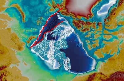
7 6 The outer limit of the exclusive economic zone is established at a distance of 200 nautical miles from the baselines from which the breadth of the territorial sea is measured, unless otherwise is stipulated by the international treaties of the Russian Federation. Requirements of Paragraph 1 of Article 75 of the Convention provide that: Subject to this Part, the outer limit lines of the exclusive economic zone and the lines of delimitation drawn in accordance with article 74 shall be shown on charts of a scale or scales adequate for ascertaining their position. Where appropriate, such limit lines or delimitation lines may be substituted by a list of geographical coordinates of points, specifying the geodetic datum. The line of the Russian exclusive economic zone is shown on the chart of Central Arctic Basin (admiralty No ), publication of the Department of Navigation and Oceanography of the Russian Ministry of Defense in The list of straight baseline points was approved by Decree of the USSR Council of Ministers of 15 January 1985 and published in the book Maritime Legislation of the Russian Federation (1994) by the Main Department of Navigation and Oceanography (admiralty No. 9055). An English translation of the said list has been officially handed over to the UN Secretary General and placed on the UN website (see List of straight baseline points 4450 RUS_1985_Declaration ). The List contains coordinates of the straight baseline endpoints. The position of the normal baselines adjoining the straight baselines in this document is recorded with the text: onwards along the low-water line up to the base point. No.. The area of the seabed of the Arctic ocean (Fig. 1), considered in this revised partial submission and relevant to the OLCS determination of the Russian Federation under article 76 of the Convention, covers the geomorphological continental shelf of the Russian Arctic marginal seas, part of the Eurasian basin (Nansen basin and Amundsen, the Gakkel ridgethe Arctic Ocean seabed area considered in this partial revised Submission that for establishment of the OLCS of the Russian Federation under Article 76 of the Convention includes the geomorphological shelf of the Russian Arctic marginal seas, part of the Eurasian Basin (the Nansen, Amundsen basins and the Gakkel Ridge), and the Central Amerasian Basin consisting of the Makarov Basin and Complex of the Central Arctic Submarine Elevations, which includes the Lomonosov Ridge, Podvodnikov Basin, Mendeleev-Alpha Rise, Mendeleev and Chukchi basins, and Chukchi Plateau. Partial revised Submission of the Russian Federation on the establishment of the OLCS in the Arctic Ocean proceeds from the scientific understanding that the constituent parts of the Complex of the Central Arctic Submarine Elevations, namely the Lomonosov Ridge, Mendeleev-Alpha Rise, and Chukchi Plateau, and separating them the Podvodnikov and Chukchi Basins have the continental origin and belong to submarine elevations that are natural components of the continental margin under paragraph 6 of Article 76 of the Convention, which are not subject to distance limit of 350 nautical miles from the baselines. The submitted OLCS line under Article 76 of the Convention in accordance with this partial revised Submission is shown on the schematic map included in the Executive Summary (Fig. 1). A more detailed description of the claimed OLCS is given below in the corresponding section of the Executive Summary. In accordance with Paragraphs and of the STG, all distances in the partial revised Submission of the Russian Federation for establishment of the OLCS in the Arctic Ocean are given in nautical miles (M) or metres (m). PARTIAL REVISED SUBMISSION OF THE RUSSIAN FEDERATION TO THE COMMISSION ON THE LIMITS OF THE CONTINENTAL SHELF IN RESPECT OF THE CONTINENTAL SHELF OF THE RUSSIAN FEDERATION IN THE ARCTIC OCEAN

8 7 Fig.1. Claimed OLCS line under Article 76 of the Convention in accordance with this partial revised Submission
9 8 Geodetic coordinates are given in two versions: degrees, minutes and seconds, accurate to the second digit after the decimal point in decimal fractions of a second; degrees, with a precision of six decimal places in decimal. In accordance with the recommendations in paragraphs of the STG, all geodetic coordinates and calculated distances used in the partial revised Submission of the Russian Federation for establishment of the OLCS in the Arctic Ocean are defined in the geocentric World Geodetic System WGS-84. Russian national geodetic and cartographic source materials are, as a rule, in the State coordinate system of 1942 (Pulkovo-42 on the ellipsoid Krassovsky 1940). For coordinate conversion from a geodetic coordinate system Pulkovo-42 in WGS-84 in the Russian Federation adopted the transformation parameters set forth both in the Parameters of the Earth 1990 (PZ ) (enacted by the Russian Government Decree of 20 June 2007 No. 797-p) and in State Standard GOST R Global navigation satellite system. Coordinate systems. Methods of transformations of the coordinates of the designated point. The Manual S-60, published by the International Hydrographic Bureau (User s Handbook on Datum transformations involving WGS-84. Monaco, 2003), contains data for coordinate transformation from the coordinate system of 1942 ( Pulkovo-1942 Russia ) in WGS-84. In this partial revised Submission, determination of the FOS points was carried out by means of the GeoCAP software using the Change of Average Gradient algorithm. 2. THE APPLICABLE PROVISIONS OF ARTICLE 76 OF THE CONVENTION The provisions of the following paragraphs of article 76 of the Convention have been used to justify the OLCS position of the Russian Federation in this revised partial Submission of the Russian Federation: paragraph 1 in relation to the concept of the continental shelf as a natural prolongation of land territory The continental shelf of a coastal State comprises the seabed and subsoil of the submarine areas that extend beyond its territorial sea throughout the natural prolongation of its land territory to the outer edge of the continental margin, or to a distance of 200 nautical miles from the baselines from which the breadth of the territorial sea is measured where the outer edge of the continental margin does not extend up to that distance ; paragraph 3 in relation to the constituent elements of the continental margin; paragraph 4 in relation to the criteria for determining the FOS in accordance with paragraphs 76.4 (a.i), 76.4 (a.ii), and 76.4(b) on the basis of morphological, bathymetric, and seismic data; paragraph 5 in relation to distance criteria for drawing the OLCS at a distance: not exceeding 350 nautical miles from the baselines from which the breadth of the territorial sea is measured, or not exceeding 100 nautical miles from the 2,500 metre isobath, which is a line connecting the depth of 2,500 metres; paragraph 6 in relation to inapplicability of the distance criterion 350 nautical miles from the baselines to submarine elevations that are natural components of the continental margin; PARTIAL REVISED SUBMISSION OF THE RUSSIAN FEDERATION TO THE COMMISSION ON THE LIMITS OF THE CONTINENTAL SHELF IN RESPECT OF THE CONTINENTAL SHELF OF THE RUSSIAN FEDERATION IN THE ARCTIC OCEAN
10 9 paragraph 7 in relation to the OLCS establishment, where that shelf extends beyond 200 nautical miles from the baselines from which the breadth of the territorial sea is measured, by straight lines not exceeding 60 nautical miles in length, connecting fixed points, defined by coordinates of latitude and longitude. 3. COMMISION MEMBERS WHO PROVIDED ADVICE IN THE PREPARATION OF THE PARTIAL REVISED SUBMISSION In preparing the partial revised Submission of the Russian Federation for establishment of the OLCS in the Arctic Ocean, scientific advice was provided by Dr. I.F. Glumov (member of the Commission from 2012 to present), Dr. Yu. B. Kazmin (member of the Commission from 1997 to 2012), and Dr. H. Brekke (member of the Commission from 1997 to 2012). None of the other members of the Commission provided advice. 4. GOVERNMENTAL INSTITUTIONS RESPONSIBLE FOR PREPARATION OF THE PARTIAL REVISED SUBMISSION OF THE RUSSIAN FEDERATION FOR ESTABLISHMENT OF THE OLCS IN THE ARCTIC OCEAN Governmental authorities responsible for the preparation of the partial revised Submission of the Russian Federation for establishment of the OLCS in the Arctic Ocean are the Federal Agency on Mineral Resources (Rosnedra) of the Ministry of Natural Resources and Environment of the Russian Federation, Ministry of Foreign Affairs of the Russian Federation, Department of Navigation and Oceanography of the Ministry of Defence of the Russian Federation, and the Russian Academy of Sciences. Text of the partial revised Submission of the Russian Federation for establishment of the OLCS in the Arctic Ocean as well as the maps, figures, annexes, and relevant databases contained in the Submission were prepared by Russian Research Institute of Geology and Mineral Resources of the World Ocean named after Academician I. S. Gramberg (I.S. Gramberg VNIIOkeangeologia ) of the Federal Agency on Mineral Resources with the participation of the State Research Navigation-Hydrographic Institute «GNINGI» (Russian Ministry of Defence) and the P.P. Shirshov Institute of Oceanology (Russian Academy of Science). 5. MARITIME DELIMITATION AND OTHER ISSUES In accordance with Paragraph 2 of Annex 1 (CLCS/40/Rev.1) of the Rules of Procedure of the Commission, the Russian Federation informs the Commission of the presence of unresolved disputes of maritime delimitation in the following areas of the Arctic Ocean: in the Amundsen Basin, on the Lomonosov Ridge, in Makarov and Podvodnikov basins - between the Russian Federation and the Kingdom of Denmark; in the Makarov Basin and on the Mendeleev Rise between the Russian Federation and Canada. In respect to delimitation of the continental shelf in the Arctic Ocean there are the following agreements in the context of paragraph 10 of Article 76 of the Convention, Article 9 of Annex II to the Convention and Rule 46 of the Rules of Procedure of the Commission and Annex 1 to the Rules of Procedure of the Commission (CLCS/40/Rev.1): Kingdom of Norway The Kingdom of Norway and the Russian Federation have held bilateral consultations on delimitation of the areas comprising the continental shelf beyond 200 nautical miles in the Barents Sea, as well as in the western Nansen Basin in the Arctic Ocean.
11 10 After the first Submission of the Russian Federation for establishment of the OLCS in the Arctic Ocean (made on December 20, 2001) concerning one of these areas, the Government of the Kingdom of Norway sent on March 20, 2002 to the Secretary General of the United Nations a note (see notification CLCS LOS/NOR) in relation to these areas. In this note, the Kingdom of Norway pointed to the large area in the central Barents Sea beyond 200 nautical miles from the baselines of the Kingdom of Norway and the Russian Federation as the subject of the above-mentioned bilateral negotiations with the Russian Federation with a view to conclude an agreement on the maritime boundary between the two States. In this case, in accordance with Rule 5(a) of Annex I of the Rules of Procedure of the Commission, the Kingdom of Norway gave consent to the Commission to consider and make recommendations based on the Submission of the Russian Federation for establishment of the OLCS in the Arctic Ocean in respect of these areas, without prejudice to the bilateral delimitation of the continental shelf between the Kingdom of Norway and the Russian Federation and by understanding the various aspects mentioned in the above note. Subsequently, the Commission recommended that in relation to the area in the Barents Sea, after the entry into force of the treaty on the maritime boundary between the Kingdom of Norway and the Russian Federation, the maps and coordinates of the delimitation line were transmitted to the Commission. The report of the UN Secretary-General Oceans and the Law of the Sea, contained in document A/57/57/Add.1, formulates recommendations of the Commission in this regard. It was stated that the delimitation line would represent the western limit of the continental shelf of the Russian Federation, as well as the eastern limit of the continental shelf of the Kingdom of Norway beyond 200 nautical miles in the Barents Sea, and that the recommendations of the Commission do not prejudge the result of bilateral delimitation. In the aforementioned note of March 20, 2002 (see Notification CLCS LOS/NOR), the Kingdom of Norway described the eastern portion of the western Nansen Basin as another subject of the above bilateral negotiations with the Russian Federation with a view to conclude a treaty on the maritime boundary between the two States. The issue of maritime delimitation in the Barents Sea and Arctic Ocean between the Russian Federation and the Kingdom of Norway was settled with the entry into force on July 7, 2011 of the Treaty between the Russian Federation and the Kingdom of Norway on Maritime Delimitation and Cooperation in the Barents Sea and the Arctic Ocean of September 15, United States of America Under the Agreement between the USSR and the USA of June 1, 1990, the Parties delimited the territorial sea, economic zones, and continental shelf in the Chukchi and Bering seas, as well as in the Arctic and Pacific oceans. The United States ratified this Agreement; the Russian Federation applies it provisionally from the date of signature to present. Kingdom of Denmark The claimed areas in the Submission of the Kingdom of Denmark in respect of the continental shelf north of Greenland substantially overlap the areas included in this partial Submission. In particular, it concerns the polar region of the Arctic Ocean and parts of the Lomonosov ridge. The Russian Federation and the Kingdom of Denmark held consultations on the issue and agreed on the following: PARTIAL REVISED SUBMISSION OF THE RUSSIAN FEDERATION TO THE COMMISSION ON THE LIMITS OF THE CONTINENTAL SHELF IN RESPECT OF THE CONTINENTAL SHELF OF THE RUSSIAN FEDERATION IN THE ARCTIC OCEAN
12 11 When one State makes Submission to the Commission, the other State shall immediately forward to the Secretary-General of the UN a diplomatic note that exactly says: 1. A State does not object to the Commission considering the Submission of the other State and make recommendations thereon; 2. The recommendations made by the Commission in respect of the Submission of one State shall be without prejudice to the rights of the other State in the course of the Commission s consideration of its own Submission; 3. The above recommendations with respect to any State shall not prejudice the delimitation of the continental shelf between the two States. Each Party refers to this agreement in its Submission to the Commission; requests the Commission to make recommendations based on this agreement; and requests the Secretary-General of the United Nations to declare the content of the above-mentioned diplomatic note to Member States of the United Nations and the States parties to the Convention. Canada Canada s upcoming Submission may relate to the areas in the Arctic Ocean included in this partial Submission. The Russian Federation and Canada held consultations on this issue and reached the following understanding: When one State makes Submission to the Commission, the other State shall immediately forward to the Secretary-General of the UN a diplomatic note that exactly says: 1. A State does not object to the Commission considering the Submission of the other State and make recommendations thereon; 2. The recommendations made by the Commission in respect of the Submission of one State shall be without prejudice to the rights of the other State in the course of the Commission s consideration of its own Submission; 3. The above recommendations with respect to any State shall not prejudice the delimitation of the continental shelf between the two States. Each Party refers to this agreement in its Submission to the Commission; requests the Commission to make recommendations based on this agreement; and requests the Secretary-General of the United Nations to declare the content of the above-mentioned diplomatic note to Member States of the United Nations and the States parties to the Convention. In view of the above, the Russian Federation requests the Commission to consider these and other materials to this partial revised Submission of the Russian Federation for establishment of the OLCS in the Arctic Ocean relating to the extended continental shelf in the Arctic Ocean and to make recommendations thereon, without prejudice to any subsequent transfer of data and other materials of the Russian Federation, the Kingdom of Denmark, Canada, the Kingdom of Norway, and the United States, or to the delimitation of the continental shelf between the Russian Federation, the Kingdom of Denmark, Canada, and the United States of America. Final delimitation of the continental shelf of the Russian Federation in the Arctic Ocean with the Kingdom of Denmark, Canada, the Kingdom of Norway, and the United States shall be carried out in accordance with
13 12 the provisions of Article 83 of the Convention (after the adoption of Commission recommendations on the Submission of the Russian Federation for establishment of the OLCS in the Arctic Ocean). Guided by the provisions of the Rules of Procedure and the STG, and also taking into account the practice of the Commission, the Russian Federation reserves the right to introduce amendments and additions to this partial revised Submission, which can be based on new or additional research data and may provide for changing the OLCS line of the Russian Federation. 6. GEOLOGY OF THE CENTRAL ARCTIC SUBMARINE ELEVATIONS COMPLEX OF THE IN LIGHT OF NEW DATA Database In the recommendations of the Commission on the first Russian Submission the main comments on substance dealt with the Lomonosov Ridge and the Mendeleev Rise, which were considered in the submission as submarine elevations under paragraph 6 Article 76 of the Convention to be natural components of the continental margin. The Commission then recommended that taking into account the information provided in the Submission, the Lomonosov Ridge cannot be considered as a submarine elevation under the Convention. The Commission also concluded that according to the current state of scientific knowledge the complex of Mendeleev-Alpha Rise cannot be considered as a submarine elevation under the Convention. The above observations of the Commission are scientific in nature and relate to such issues as a natural prolongation and nature of the Lomonosov Ridge, geology, tectonic position and nature of the Mendeleev-Alpha Rise and the Podvodnikov Basin. The Commission considered the matters related to nature of the acoustic basement and the composition and nature of the Earth s crust in these structures. The Submission s viewpoint on the continental origin of the elevations was not supported by the Commission. Although the recommendations admit the existence of several hypotheses aimed at explaining the origin of the Mendeleev-Alpha Rise complex (a displaced fragment of the continent, the extinct axis of seafloor spreading, a large oceanic igneous province), only the last viewpoint was taken into account, namely that the Mendeleev-Alpha Rise formed as a large volcanic oceanic plateau built on the oceanic crust of the Canada Basin after its opening as a result of passage of the magmatic hot spot. The analysis of the recommendations has indicated that main cause of the conclusions drawn by the Commission was such a factor as the state of scientific knowledge at the time of consideration of the first Submission, a reference to which is made in the recommendations. It should be noted that at that time the main available seismic reflection database included only surveys carried out before 1990 from drifting ice stations. Only from the early 1990 s, the MCS observations from the icebreakers started. In the area of the Lomonosov Ridge, at the beginning of 2002, the database of seismic surveys comprised only five intersections by drifting ice stations with the relevant quality of reflection seismic data and six intersections by the MCS lines from the icebreakers. Within the Mendeleev-Alpha Rise, there was a limited number of drifting ice stations with reflection seismic observations and three short MCS lines run by the RV Polarstern in Seismic lines were also run by refraction and reflection seismic from ice across the Podvodnikov Basin to the Makarov Basin ( ), across the Lomonosov Ridge (1992), and in on the Mendeleev Rise. Thus, most of the few MCS lines with relatively modern research technologies from the research vessels were run in the area of the Lomonosov Ridge. The Mendeleev and Alpha rises and the Podvodnikov PARTIAL REVISED SUBMISSION OF THE RUSSIAN FEDERATION TO THE COMMISSION ON THE LIMITS OF THE CONTINENTAL SHELF IN RESPECT OF THE CONTINENTAL SHELF OF THE RUSSIAN FEDERATION IN THE ARCTIC OCEAN
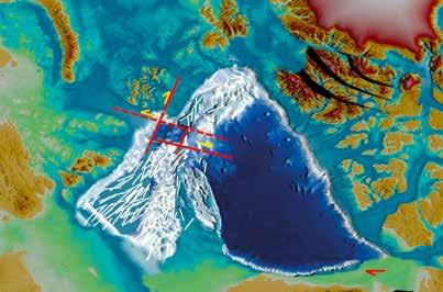
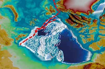
14 13 and Makarov basins were virtually not covered by the MCS and DSS-refraction sounding, except for three rather short reflection lines from the RV Polarstern in Basalt samples, on the basis of which farreaching conclusions about the origin of the Mendeleev-Alpha Rise were made in 2002, were taken only in one place. Contradictory information was given about the composition of these volcanic rocks with an absolute age of 82 Ma. In , the Russian organizations carried out a wide range of geological and geophysical studies in order to prepare a partial revised Submission of the Russian Federation in the Arctic Ocean taking into account the recommendations of the Commission of After 2002, in the central Arctic Basin Russia accomplished: deep seismic sounding of over 4,000 km; over 23,000 km of MCS lines; over 35,000 km of bathymetry survey; 120 stations of geological sampling. Examples of some latest trans-regional MCS lines are shown in Fig. 2 large complex of geological and geophysical studies was carried out in recent years by the Danish, Canadian and American researchers [Funck et al., 2011]. However, most of the results of these studies are restricted and not available in public domain. It should be noted that the most significant event was the first deep-water drilling in the Arctic on the Lomonosov Ridge in 2004 (Project IODP\ACEX). Comparison of databases on the main type of research, namely MCS obtained before 2002 and as of the beginning of 2015 is illustrated in Fig. 3. Geological Setting. Russian MCS surveys in 2011, 2012 and 2014 resulted in extensive regional seismic lines across the entire Arctic and provided scientific data for better understanding of the composition and structure of the Eurasian and Amerasian basins. General bathymetry and seismic lines clearly demonstrate that the Lomonosov Ridge, the Mendeleev Rise, the Chukchi Rise and separating them the Podvodnikov Basin and the Chukchi Basin form a single consolidated block of continental crust Complex of the Central Arctic Submarine Elevations elevated to 1.5 km above the level of the deep seabed of the Canada Basin and Amundsen Basin. This block is a component of the continental margin of the Arctic Ocean and constitutes a natural prolongation of the continental margin of Eurasia (Fig. 4). Natural prolongation. Bathymetric and seismic surveys of point to a natural morphological prolongation without traces of any interruption or tectonism, of shallow shelves of the East Siberian and Chukchi seas to the Lomonosov Ridge and the Mendeleev Rise. The seismic refraction and reflection data provide evidence of a natural prolongation of the sedimentary cover and the Earth s crust from the shallow shelf to the submarine elevations and lows of the Podvodnikov and Chukchi basins in the Amerasian Basin. Rifting Extension. The MSC sections clearly illustrate that the shelf of the East Siberian Sea, the Lomonosov Ridge, the Podvodnikov Basin, the Mendeleev-Alpha Rise, the Chukchi Basin and the Chukchi Caps are the structures of rifting extension and expansion, which is the most important factor in relation to the origin and tectonic evolution of the Amerasian Basin. The entire area of the Central Arctic Elevations Complex is controlled by normal faults, grabens, semi-grabens and other tectonic structures of rifting, extension and expansion of the Earth s crust (tilted blocks, listric faults, growth faults, drag folds, etc.). The structures that are consistent with this type of rifting and extension occur ubiquitously within the Central Arctic Elevations Complex. Bathymetric and seismic data indicate an approximate north-south orientation of the structures formed along the extension stretching in the east-west direction, which is similar to the directions mapped on the adjacent shallow shelves in the Russian Arctic.


15 14 Fig.2. Examples of some modern Russian trans-regional MCS line PARTIAL REVISED SUBMISSION OF THE RUSSIAN FEDERATION TO THE COMMISSION ON THE LIMITS OF THE CONTINENTAL SHELF IN RESPECT OF THE CONTINENTAL SHELF OF THE RUSSIAN FEDERATION IN THE ARCTIC OCEAN
 showed up.")
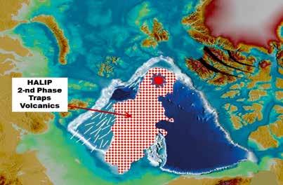
![The first phase of magmatism with the age of 120-130 Ma on the Mendeleev Rise was confirmed in 2012 by sampling basalts with the age of 128 Ma [Morozov et al., 2013].](/docs-images/74/70871562/images/16-1.jpg "A younger, second phase of magmatism (80-90 Ma) is represented by the majority of samples taken in the area of the Mendeleev-Alpha Rise. According to Mukasa et al.")
16 15 Fig.3. Comparison of the databases on MCS surveys before 2002 and at the beginning of 2015 Magmatism. Based on the latest data it was ascertained that within most parts of the Central Arctic Elevations Complex two phases of magmatism of the High Arctic Large Igneous Province (HALIP) showed up. The first phase of magmatism with the age of Ma on the Mendeleev Rise was confirmed in 2012 by sampling basalts with the age of 128 Ma [Morozov et al., 2013]. A younger, second phase of magmatism (80-90 Ma) is represented by the majority of samples taken in the area of the Mendeleev-Alpha Rise. According to Mukasa et al. [2009, 2012], the samples taken by the icebreaker Healy north of the Chukchi Cap are represented by sub-alkaline basalts; on the Northwind Ridge - by alkaline basalts; on the Mendeleev Rise - by sub-alkaline and alkaline basalts. Basaltic volcanism of the Amerasian Basin is similar to magmatic shows of the same age and composition in the known continental structures of the Arctic Basin: Svalbard, Franz Josef Land, De Long Archipelago, Ellesmere Island and other islands of the Canadian Arctic Archipelago [Maher, 2001]. Analysis of basalt samples showed that they were represented by volcaniclastic rocks -products of underwater subaerial eruptions in a shallow water environment.

17 16 Fig.4. Composite MCS line through the Arctic Ocean from the Siberian shallow shelf in the west to the Canada Basin in the east Acoustic basement. The results of the MCS carried out by the Russian and foreign scientists in show that bright high-amplitude reflections occur at the boundary of the acoustic basement, in places continuous, sometimes with sharp breaks, often disrupted, passing into chaotic ones, occurring at the top of the acoustic basement or above the basement below the stratified sedimentary sequence. These acoustic facies are interpreted as sequences composed of basalt flows and sills alternating with thick layers of tuffs and, possibly, sedimentary rocks. Volcanic sequences are developed both within the grabens, and on the slopes and structural elevations indicating that they formed during rifting, extension and expansion of the basement and the formation of grabens as a result of fault tectonics. Seismic stratigraphic analysis of the materials of recent Russian MCS in 2011, 2012 and 2014 shows that on the Mendeleev-Alpha Rise and the Chukchi Cap, and the separating Chukchi Basin the acoustic basement is overlain by flood basalts traps and the associated volcanics. Thickness of the volcanic section varies greatly - from the first hundreds of meters on the slopes and local highs to km in recent basement depressions. Traps are represented by variations of trachybasalts and alkaline basalts, which is not typical for the large igneous provinces of continents and oceans. The available data based on the obtained samples support the viewpoint that the synrift basalts erupted at the early stages of continental crust rifting in the Amerasian Basin ( Ma). A younger, second stage of volcanism (80-90 Ma) completes the Mesozoic stage of the HALIP bimodal volcanism during rifting extension in the Russian Arctic and the Amerasian Basin. In , in many areas of submarine elevations in the Arctic Ocean, rock material dredging was conducted which provided information on a possible type and age of basement under the covers of traps. During the Russian marine expeditions, numerous sedimentary, metamorphic and igneous rocks were dredged on the escarps of the Mendeleev Rise (Morozov, 2013) (Fig. 6). Sedimentary rocks are represented by carbonate and clastic varieties. Sandstones show different age of detrital zircons including the Archean and Proterozoic. The youngest zircon populations give ages of Ma and Ma, suggesting the occurrence of the Paleozoic and Triassic-Early Jurassic sandstones in the acoustic PARTIAL REVISED SUBMISSION OF THE RUSSIAN FEDERATION TO THE COMMISSION ON THE LIMITS OF THE CONTINENTAL SHELF IN RESPECT OF THE CONTINENTAL SHELF OF THE RUSSIAN FEDERATION IN THE ARCTIC OCEAN
18 17 basement. Carbonate rocks are represented by limestones and dolomites. Limestones contain macrofauna of the Middle and Late Paleozoic. Type of crust. The STG of the Commission (paragraph 7.2.9) state that the geological crust types cannot be the sole qualifier in the classification of ridges and elevations of the sea floor into legal categories of paragraph 6 of Article 76. This conclusion is fully valid in relation to the Arctic Basin. Shelf crust covering almost all shallow-water areas of the Arctic Ocean is a thinned continental crust (about 35 km) with a very uniform basement, but with a very diverse structure. Deep seismic sounding lines (DSS) were run on the East Siberian shelf along and across the strike of the Lomonosov Ridge and the Podvodnikov Basin. However, the processing and the interpretation did not allow a reliable determination of the crust types due to an ambiguous interpretation of seismic velocities in the lower crust above the Moho discontinuity. Processing and interpretation of the same DSS projects and experiments by different authors give different results and significant variations in velocities. Thus, high seismic velocities in the lower crust cannot be considered as the sole qualifier in determination of the oceanic or continental type of the crust. Of great importance is the fact that the DSS line ( Dreamline ) obtained in 2010 on the East Siberian shelf with continental crust gives values of seismic velocities in the lower crust above the Moho discontinuity (7.2 m/s) similar to those on the DSS line of 2012 across the strike of the Mendeleev Rise ( m/s), which may testify in favor of the continental crust type of the Mendeleev Rise. Geological model of formation of the Arctic Basin. The STG of the Commission (paragraph 7.3.1) state that in case of submarine elevations according to paragraph 6 of the Convention the list of such elevations contained in the Convention is not complete: Common to all these elevations is that they are natural components of the continental margin. This makes it relevant to consider the formation processes of continental margins and growth of continents. Scientific data obtained in the period of do not confirm the viewpoint supported in the first recommendations of the Commission of 2002 that the complex of the Mendeleev-Alpha Rise formed as a large volcanic oceanic plateau built on the oceanic crust of the Canada Basin after its opening as a result of a passage of a magmatic hot spot. These hypotheses were based on geological data and information on the adjacent land due to the absence or scarcity of the necessary geological and geophysical data on the deep-water part of the Arctic Basin at the time. In this connection, for the purposes of this partial revised Submission, a geological model of evolution of the Arctic Basin taking into account the new data was developed and proposed (Fig. 5). A three-stage model of formation of the Arctic Basin is proposed. According to modern notions, the Arctic Basin did not exist in the Triassic (225 Ma). Its future origination site was on the margin of the Pangea Paleocontinent on the coast of the Angayucham Sea - the gulf of the Paleopacific Ocean (Paleopacific). Stage 1. The Arctic Ocean originated as a result of opening of the Canada Basin during the Late Jurassic-Early Cretaceous as a back-arc basin with a subduction zone in the Pacific Ocean mainly along the Late Paleozoic Ellesmerian orogenic system. A.Grantz (1998) after S.Carey (1958) suggested that opening of the Canada Basin was a result of counterclockwise rotation of the Arctic Alaska-Chukotka block by 66 from the Canadian Arctic along a strike-slip zone at the Lomonosov Ridge with the rotation center in the area the Mackenzie River mouth. Since then such a rotational model has become popular among many scientists. We accept a rotational model
19 18 for the Canada basin development, but with the location of the transform (strike-slip) fault along the eastern margin of the present Alpha- Mendeleev Rise and the Chukchi Rise, not along the Lomonosov Ridge. After opening of the Canada Basin, the modern Complex of the Central Arctic Submarine Elevations became a part of the Siberian shelf and, therefore, a natural component of the Chukchi-Siberian continental margin. Stage 2. In this period, the formation of submarine elevations occurs as a result of rift stretching of the continental crust from the Lomonosov Ridge eastwards. In the area of the shelf seas, from the Laptev Sea to the Chukchi Sea, rifting started simultaneously across the territory at about Middle Aptian. Rifting and stretching showed up in the Podvodnikov Basin and the Chukchi Basin, which led to their subsidence. During the period Ma, the first phase of the HALIP traps magmatism showed up extensively. Simultaneously with the beginning of magmatic activity, rifting and stretching of the thinned and heated lithosphere developed. Under such conditions, stretching of the crust could reach % or more. The second phase of the HALIP traps magmatism showed up in the Late Cretaceous in the interval Ma. Rifting at this stage had a shear component in the modern sub-polar region, which led to formation of the Makarov Basin as a near-shear pull-apart basin ( Ma). Modern horst-graben morphology of elevations and basins in the Amerasian Basin is a result of the rift stretching simultaneously with the first phase of traps magmatism. The second phase of magmatism, in the Late Cretaceous, subsidence of a block of the Central Arctic Submarine Elevations occurred, and the process of sedimentation in the Late Cretaceous-Paleogene began. Cesar and T-3 expedition took samples of the Maastrichtian-Campanian sedimentary rocks from the base of the sedimentary cover atop basalts. Stage 3. As a result of spreading along the Gakkel Ridge, which began 56 Ma ago, opening of the Eurasian Basin occurred. The Lomonosov Ridge splits off and moves away from the Barents- Kara shelf. It becomes a part of the Complex of the Central Arctic Submarine Elevations. In the Amerasian Basin, rifting and stretching continue within the Chukchi Borderland, the Mendeleev- Alpha Rise, in the Podvodnikov Basin and the Chukchi Basin as well as on the Lomonosov Ridge. The tectonic activity attenuates in the Middle Miocene to formation of the upper, tectonically undisturbed hemipelagic sedimentary cover continuously blanket-style covering almost the entire area of the Mendeleev-Alpha Rise, the Lomonosov Ridge and the Chukchi Cap as well as the Podvodnikov and Chuchi basins.. The Fig. 6 shows a scheme of major structural and tectonic elements and geological position of the region related to this partial revised Submission. PARTIAL REVISED SUBMISSION OF THE RUSSIAN FEDERATION TO THE COMMISSION ON THE LIMITS OF THE CONTINENTAL SHELF IN RESPECT OF THE CONTINENTAL SHELF OF THE RUSSIAN FEDERATION IN THE ARCTIC OCEAN


20 19 Fig.5. Scheme of the Arctic Ocean basins development
21 20 7. DESCRIPTION OF THE RUSSIAN CONTINENTAL SHELF OUTER LIMIT LINE ALONG ITS SECTIONS The Russian Federation OLCS revised line in the Arctic Ocean is constructed in accordance with paragraphs of Article 76 of the Convention and is shown in Fig.1 and 7. The OLCS consists of a series of consecutive sections (II-VII) fixed by geodetic coordinates of separate numerous points and presented in the form of a table of coordinates of fixed points of the revised OLCS of the Russian Federation in the Arctic Ocean. OLCS position is determined various criteria specified in article 76 of the Convention. Areas of legal continental shelf of the Russian Federation are located not further than 100 nautical miles from the 2,500 m isobath in the Nansen and Amundsen basins. The area of the Russian Federation extended continental shelf in accordance with the Russian Federation partial revised Submission for establishment of the OLCS in the Arctic Ocean is 1,191,347 sq. km (Fig. 1). Analysis of bathymetric and seismic data was performed using the software package GeoCAP that implements the mathematical analysis of two-dimensional bathymetric profiles using three-dimensional bathymetric models of bottom topography. The digital bathymetric models were used to generate the bathymetric profiles for the purpose of analysis of the FOS point positions and fixing the positions of the 2,500 m isobaths points. The GeoCAP project attached to the Russian Federation partial revised Submission for the establishment of the OLCS in the Arctic Ocean contains all calculated results as a combination of the formula and constraint lines in accordance with the requirements of Article 76 of the Convention. The final results are also incorporated into a geographic information system database. Fig illustrate the schematic maps of the Russian Federation OLCS in the Arctic Ocean, which show the formula and constraint lines as well as the seven sections of the OLCS revised line: Sea floor area bounded by the limits of sections II-III-IV-V includes the southern Gakkel Ridge and the adjacent ocean areas of the Nansen and Amundsen basins and belongs to the extended continental shelf of the Russian Federation [76.3]. Sea floor area bounded by the limits of sections IV-V-VI. Assignment to the Russian Federation extended continental shelf of the entire sea floor area in this region, except the Makarov Basin, is based on the belonging of this area to the natural components of the Russian continental margin [76.6]. A small part of the sea floor area in the Makarov Basin with a possible oceanic crust is included into the extended continental shelf of the Russian Federation on the basis of the criterion of 60 nautical miles from the FOS [76.4.a.ii]. Sea floor area bounded by the limits of section VII is within the Makarov Basin and the Mendeleev Rise is based on affiliation of the Mendeleev Rise to the natural components of the Russian continental margin [76.6]. Geographic coordinates of the sections fixed points were determined on the basis of the criteria provided for in Article 76 of the Convention. The considered areas are located completely seaward of the 2,500 meter isobath in the Nansen and Amundsen basins, and are not further than 100 nautical miles from the 2,500 meter isobath [76.5] in the vicinity of the Lomonosov Ridge and the Mendeleev Rise slopes. PARTIAL REVISED SUBMISSION OF THE RUSSIAN FEDERATION TO THE COMMISSION ON THE LIMITS OF THE CONTINENTAL SHELF IN RESPECT OF THE CONTINENTAL SHELF OF THE RUSSIAN FEDERATION IN THE ARCTIC OCEAN


22 21 Fig.6. Scheme of major structural and tectonic elements in the areas that are relevant to the presented partial revised Submission
23 22 SECTION I is not the OLCS section and is drawn along the delimitation line of the bilateral maritime boundary between the Russian Federation and the Kingdom of Norway in the Barents Sea and the Arctic Ocean (Fig. 7), which is fixed in the Treaty between the Russian Federation and the Kingdom of Norway of September 15, In accordance with the Treaty (Article 1, paragraph 1) the OLCS common point of the Kingdom of Norway and the Russian Federation, which is the end point of the delimitation line, is established according to the following rules: Endpoint of the delimitation line is defined as a point of intersection of a geodetic line drawn through points 7 and 8, and the geodesic line joining the easternmost point of the outer limit of the continental shelf of Norway and the westernmost point of the outer limit of the continental shelf of the Russian Federation, as established in accordance with Article 76 and Annex II of the Convention. Coordinates of points 7 and 8 set by the Treaty between the Kingdom of Norway and the Russian Federation (Article 1, paragraph 1) are given below: 7. latitude: N; longitude: E; 8. latitude: N; longitude: L36 E; According to the text of The Continental Shelf Submission of Norway Executive Summary (2006), the eastern point of the OLCS of the Kingdom of Norway (point A01 ) has the following coordinates: latitude: N; longitude: E (in coordinate system WGS-84); The westernmost fixed point of the Russian Federation OLCS (point 2G 2 ) determined by the Gardiner formula (sedimentary cover thickness exceeds or is equal to 1% of the shortest distance to the FOS) has the following coordinates: latitude: N; longitude: E (in coordinate system WGS-84); Intersection of the geodetic line connecting these points with the geodetic line passing through points 7 and 8 (the coordinates of which are given in paragraph 1, Article 1 of the Treaty between the Russian Federation and the Kingdom of Norway) makes it possible to fix the Russian Federation OLCS initial point (common with the OLCS of the Kingdom of Norway) according to the rules established in accordance with Article 76 of the Convention and Annex II of the Convention. Thus, the initial westernmost point of the OLCS of the Russian Federation (point 2C 1 ) has the following coordinates: latitude: N; longitude: E (in coordinate system WGS-84); The distance between points 2G 2 and 2C 1 is km (28.56 nautical miles). Northern part of the delimitation line of the bilateral maritime boundary between the Russian Federation and the Kingdom of Norway in the Barents Sea and the Arctic Ocean, as well as the easternmost point of the OLCS of the Kingdom of Norway (point A01 ), the western point of the Russian Federation OLCS (point 2C 1 ) and the initial point of the Russian Federation OLCS (point 2C 1 ) are shown on the map (Fig. 7). SECTION II of the Russian Federation OLCS revised line is drawn along the line connecting 7 fixed points constructed on the basis of Hedberg formula (FOS + 60M) and Gardiner formula (Fig. 8), which do not go beyond the distance limit of 350 nautical miles from the points of baselines of the Russian Federation [76.5]. PARTIAL REVISED SUBMISSION OF THE RUSSIAN FEDERATION TO THE COMMISSION ON THE LIMITS OF THE CONTINENTAL SHELF IN RESPECT OF THE CONTINENTAL SHELF OF THE RUSSIAN FEDERATION IN THE ARCTIC OCEAN

24 23 Fig.7. Revised OLCS of the Russian Federation in the Arctic Ocean

25 24 Fig.8. Schematic map of the OLCS of the Russian Federation in the Arctic Ocean, sections I II PARTIAL REVISED SUBMISSION OF THE RUSSIAN FEDERATION TO THE COMMISSION ON THE LIMITS OF THE CONTINENTAL SHELF IN RESPECT OF THE CONTINENTAL SHELF OF THE RUSSIAN FEDERATION IN THE ARCTIC OCEAN

26 25 Fig.9. Schematic map of the OLCS of the Russian Federation in the Arctic Ocean, sections III IV

27 26 Fig.10. Schematic map of the OLCS of the Russian Federation in the Arctic Ocean, sections V VI PARTIAL REVISED SUBMISSION OF THE RUSSIAN FEDERATION TO THE COMMISSION ON THE LIMITS OF THE CONTINENTAL SHELF IN RESPECT OF THE CONTINENTAL SHELF OF THE RUSSIAN FEDERATION IN THE ARCTIC OCEAN

28 27 Fig.11. Schematic map of the OLCS of the Russian Federation in the Arctic Ocean, section VII
29 28 For the formation of the OLCS on section II, seismic bathymetric lines with numbers 3, 4, 5, 6 and 10 were used derived from the data of multibeam surveying and multichannel seismic surveying in 2011, as well as bathymetric line 7 formed on the basis of retrospective bathymetric data. With the help of the GeoCAP software package, analysis of each line was performed and the FOS points were determined. Then, after Hedberg formula (FOS + 60M), 2Н 6 point was determined. Points 2G 2, 2G 3, 2G 4, 2G 5 and 2G 7 on seismic bathymetric lines were obtained on the basis of Gardiner criterion. The distance between fixed points received according to the Gardiner and Hedberg formula does not exceed 60 nautical miles. Between fixed points: 2C 1, 2G 2, 2G 3, 2G 4, 2G 5, 2H 6 and 2G 7 the OLCS line is fixed by the coordinates of points of the geodetic line connecting these fixed points. The coordinates of fixed points of the OLCS in section II are given in the Table of the Annex.A fragment of a detailed map illustrating section II of the revised line of the OLCS of the Russian Federation is presented in Fig.8. The end point of section II of the OLCS is point 3E 1 common with section III. SECTION III of the revised line of the Russian OLCS is drawn along a line of 24 points coinciding with the boundary of the exclusive economic zone of the RF in the Arctic Ocean, held at a distance of 200 nautical miles from the baselines of the Russian Federation. Position of island territories of the Russian Federation provides possibility of inclusion into the 200- mile zone of the Russian Federation in this area a part of the abyssal Nansen Basin. A fragment of the detailed map illustrating section III of the revised line of the OLCS of the Russian Federation in the Arctic Ocean is shown in Fig. 9. SECTION IV of the revised OLCS line of the Russian Federation is drawn along the line connecting 4 fixed points, 3E 24, 4G 1, 4G 2, 4G 3 constructed on the basis of Gardiner formula on seismic bathymetric lines 1407, One fixed point 5H 1 calculated from Hedberg formula is also used (bathymetric line 36, surveying of 2010). These fixed points are connected by straight lines making up the OLCS (Fig. 9). Distance between the fixed points obtained according to Gardiner and Hedberg formula does not exceed 60 nautical miles. Line of the OLCS on section IV is drawn in accordance with the new geological and geophysical data confirming the affiliation of the Lomonosov Ridge to the natural prolongation of the continental margin of Eurasia [76.6] and does not go beyond the distance limit of 350 nautical miles from the baselines, from which the breadth of the territorial sea is measured [76.5]; it also not beyond the distance limit 100 nautical miles from 2,500 m isobath (point 5H 1 ). Between fixed points 3E 24 4G 1, 4G 2, 4G 3 and 5H 1 the OLCS line is determined by the coordinates of points of the geodetic line connecting the above fixed points. Coordinates of the fixed points of the OLCS in section IV are given in the Table of the Annex. A fragment of the detailed map illustrating section IV of the line of the OLCS of the Russian Federation in the Arctic Ocean is shown in Fig. 9. SECTION V of the revised OLCS line of the Russian Federation in the area of the central part of the Amundsen Basin is based on the Hedberg formula (Fig. 10) and drawn across the points fixed on bathymetric lines with numbers 36, 37 and 38 [76.4.a.ii]. The last point of section V with number 6G 1 is constructed on the basis of the Gardiner formula on seismic bathymetric line 1439A (2014 survey). The limit does not go beyond the distance limit of 100 nautical miles from the 2,500 meter isobath [76.5]. Coordinates of the OLCS in the Amundsen Basin are determined by the method of conjugate arcs with subsequent straightening in the place of arcs conjugation. PARTIAL REVISED SUBMISSION OF THE RUSSIAN FEDERATION TO THE COMMISSION ON THE LIMITS OF THE CONTINENTAL SHELF IN RESPECT OF THE CONTINENTAL SHELF OF THE RUSSIAN FEDERATION IN THE ARCTIC OCEAN
30 29 Straightening of the OLCS line, determined by the method of conjugate arcs, is performed using the option Maximizing the Outer Limit Line implemented in the software package GeoCAP. Using this option allows switching from the conjugate arcs drawn from the points of the FOS with a radius of 60 nautical miles to the uniform line of the OLCS. Section V of the OLCS is fixed by 21 points, the names of which start with the prefix 5H ; some of them are specific points, indicating the beginnings and ends of sections straightening the OLCS line. Distance between the specific points, in accordance with requirements of the Article [76 4.a.ii], does not exceed 60 nautical miles. Specific points have numbers 5H 1, 5H 5, 5H 6, 5H 14, 5H 15 and 5H 20. Other filling points are given at intervals of 5 km. Point with number 6G 1 is the initial point of section VI and has coordinates: latitude: ,13 N; longitude: W (in coordinate system WGS-84); Coordinates of the points of section V are given in the Table of the Annex. OLCS position on section V is shown on the map in Fig. 10. SECTION VI of the OLCS revised line of the Russian Federation in the polar region of the Amundsen Basin and in the Makarov Basin is drawn on the basis of Hedberg and Gardiner formula [76.4.a.ii ] (Fig. 10). The 60 nautical miles radius arc was drawn from the FOS points on the seismic bathymetric line 1439A and bathymetric lines The point defined by the sediment thickness formula on the seismic bathymetric lines 1439A was connected with these Hedberg arcs using the conjugate arcs option implemented in the software package Geocap providing the straightening of the OLCS line. The limit is not beyond 100 nautical miles distance from the 2,500 meter isobath [76.5]. The OLCS coordinates on this section are determined by the method of conjugate arcs with subsequent straightening in places of arcs conjugation. The limit is not beyond 100 nautical miles distance from the 2,500 meter isobath [76.5]. The OLCS coordinates on this section are determined by the method of conjugate arcs with subsequent straightening in places of arcs conjugation. Section VI of the OLCS is fixed by 52 points, the names of which start with prefix 6H, some of them are specific points of the beginning and end of the sections straightening the OLCS line. The distance between the specific points, in accordance with the requirements of the Article [76.4.a.ii], does not exceed 60 nautical miles. Specific points have numbers: 6Н 2, 6Н 36, 6Н 37 and 6Н 52. Other filling points are given at intervals of 5 km. Point with number 6H 52 is the initial point of section VII and has coordinates: latitude: ,27 N; longitude: W (in coordinate system WGS-84). Coordinates of section VI are given in the Table of the Annex. The OLCS position on section VI is shown in the map in Fig. 10. SECTION VII of the revised line of the OLCS of the Russian Federation is drawn along the line coinciding with the sector line of the Russian Federation in the Arctic Ocean (Fig. 11). The sector line is approved by the Decree of the Presidium of the Supreme Council of the USSR No dated 21 February, The Decree provided for making clarification to presentation in the Soviet maps of the eastern boundary of polar domains of the USSR in the Arctic Ocean, replacing the numerical value of the meridian W on the Order of the Presidium of the USSR Central Executive Committee
31 30 of 1926 On the declaration the territory of the USSR of lands and islands in the Arctic Ocean to the new value: W (in Krasovsky ellipsoid). In the coordinate system WGS-84, this meridian has the value W recorded in the Agreement between the United States of America and the Union of Soviet Socialist Republics on Maritime Boundary in the Chukchi and Bering Seas signed in Section VII of the revised Russian Federation OLCS line will be the subject of negotiations with the Kingdom of Denmark and Canada. The limit on section VII is also drawn along a conditional delimitation line of the maritime spaces between the Russian Federation and the USA in the context of the Agreement between the United States of America and the Union of Soviet Socialist Republics on Maritime Boundary signed in The United States ratified this Agreement; the Russian Federation applies it provisionally from the date of signature to present.coordinates of the points forming the delimitation line of maritime spaces between the USSR and the United States according to the Agreement of are presented at the UN website (see the Agreement between the United States of America and the Union of Soviet Socialist Republics USA- RUS1990MB). The agreement between the USSR and the USA on Maritime Delimitation concerns the Chukchi and Bering seas. The Agreement has fixed the initial point of delimitation (point 1) in the Bering Strait. Article 2 of the Agreement between the USSR and the USA (paragraph 1) states: From the initial point of N, W the maritime boundary extends north along the W across the Bering Strait and Chukchi Sea into the Arctic Ocean as far as permitted under international law. In the context of the Agreement between the USSR and the USA on Maritime Delimitation the delimitation line of maritime spaces in the Arctic Ocean should be extended to the intersection point with the median line, which determines the maritime delimitation between Canada and the United States. This point, called the starting point of the conditional maritime boundary of the USSR and the USA (point US- RF), has coordinates: latitude: N; longitude: W (in coordinate system WGS-84). The intermediate point on section VII is the point of intersection of the lines of 200M limit of the exclusive economic zone of the Russian Federation in the Chukchi Sea with the limit on section VII (EEZ point). EEZ point has coordinates: latitude: N; longitude: W (in coordinate system WGS-84). The endpoint of section VII is the initial point of delimitation (point 1) determined in accordance with the Agreement between the USSR and the USA on Maritime Delimitation in the Chukchi and Bering Seas, which has coordinates: latitude: N; longitude: W (in coordinate system WGS-84). The coordinates of the initial point and the endpoint of section VII are given in the Table of the Annex (point with names US-RF and Point 1, respectively). PARTIAL REVISED SUBMISSION OF THE RUSSIAN FEDERATION TO THE COMMISSION ON THE LIMITS OF THE CONTINENTAL SHELF IN RESPECT OF THE CONTINENTAL SHELF OF THE RUSSIAN FEDERATION IN THE ARCTIC OCEAN
32 31 COORDINATES OF FIXED POINTS OF THE REVISED OLCS OF THE RUSSIAN FEDERATION IN THE ARCTIC OCEAN Outer Limit Fixed Point Name Type of OLCS Fixed point Latitude N (deg. min. sec.) Longitude E\W (deg. min. sec.) Latitude N (deg.) Longitude E\W (deg.) Distance between points, nautical miles / kilometres Coordinate system WGS Area II, western Nansen Basin 1 2C 1 Common Points 84 37'51.25"N '15.59"E /0.00 Note Common OLCS (.) of the RF and Norway 2 2G 2 Gardiner 84 29'19.21"N '16.81"E /52.90 СБП 3 3 2G 3 Gardiner 84 58'54.98"N '14.60"E /94.17 СБП 4 4 2G 4 Gardiner 85 20'13.47"N '00.63"E /73.68 СБП 5 5 2G 5 Gardiner 85 19'25.48"N '23.12"E /80.61 СБП 6 6 2H 6 Hedberg 85 02'53.58"N '29.11"E / СБП 7 7 2G 7 Gardiner 84 49'54.11"N '47.91"E / СБП E miles 84 34'23.70"N '03.92"E / Common (.) of area II-III Outer Limit Fixed Point Name Type of OLCS Fixed point Latitude N (deg. min. sec.) Longitude E\W (deg. min. sec.) Latitude N (deg.) Longitude E\W (deg.) Distance between points, nautical miles / kilometres Area III, eastern Nansen Basin 8 3E 1 200miles 84 34'23.70"N '03.92"E / Common (.) of area II-III 9 3E miles 84 34'26.43"N '30.13"E / E miles 84 34'45.62"N '43.10"E / E miles 84 35'01.42"N '01.65"E / E miles 84 35'14.38"N '24.02"E / E miles 84 35'23.92"N '50.02"E / E miles 84 35'29.90"N '18.44"E / E miles 84 35'32.46"N '48.22"E / E miles 84 35'31.41"N '18.26"E / E miles 84 35'26.91"N '47.40"E / E miles 84 35'18.92"N '14.55"E / E miles 84 35'07.44"N '38.61"E / E miles 84 34'52.46"N '58.53"E / E miles 84 34'34.06N '13.20"E / E miles 84 34'12.50"N '21.92"E / E miles 84 33'47.48"N '23.34"E / E miles 84 33'19.08"N '16.44"E / E miles 84 32'47.22"N '00.10"E / E miles 84 32'11.97"N '33.33"E / E miles 84 31'33.38"N '55.18"E / E miles 84 30'51.44"N '04.72"E / E miles 84 30'06.22"N '00.91"E / E miles 84 29'17.66"N '42.94"E / E miles 84 29'08.25"N '35.02"E /0.92 Common (.) of area III-IV Note
33 32 Outer Limit Fixed Point Name Type of OLCS Fixed point Latitude N (deg. min. sec.) Longitude E\W (deg. min. sec.) Latitude N (deg.) Longitude E\W (deg.) Distance between points, nautical miles / kilometres Area IV, eastern Amundsen Basin 31 3E miles 84 29'08.25"N '35.02"E /0.92 Note Common (.) of area III-IV 32 4G 1 Gardiner 85 19'05.46"N '43.90"E / СБП G 2 Gardiner 85 46'49.14"N '41.90"E /60.29 СБП G 3 Gardiner 86 35'45.56"N '10.42"E / СБП H 1 Hedberg 87 30'12.67"N '38.77"E / БП 36 Common (.) of area IV-V Outer Limit Fixed Point Name Type of OLCS Fixed point Latitude N (deg. min. sec.) Longitude E\W (deg. min. sec.) Latitude N (deg.) Longitude E\W (deg.) Distance between points, nautical miles / kilometres Area V, central Amundsen Basin 35 5H 1 Hedberg 87 30'12.67"N '38.77"E / Note БП 36 Common (.) of area IV-V 36 5H 2 Hedberg 87 31'28.03"N '59.57"E /2.66 БП H 3 Hedberg 87 33'52.67"N '19.87"E /5.00 БП H 4 Hedberg 87 36'19.86"N '21.18"E /5.00 БП H 5 Hedberg 87 38'49.41"N '10.63"E /5.00 БП H 6 Hedberg 88 00'46.90"N '01.04"E /44.72 БП H 7 Hedberg 88 03'11.77"N '43.18"E /5.00 БП H 8 Hedberg 88 05'39.05"N '15.28"E /5.00 БП H 9 Hedberg 88 08'08.57"N '46.68"E /5.00 БП H 10 Hedberg 88 10'40.19"N '27.23"E /5.00 БП H 11 Hedberg 88 13'13.73"N '27.89"E /5.00 БП H 12 Hedberg 88 15'49.01"N '00.93"E /5.00 БП H 13 Hedberg 88 18'25.85"N '19.62"E /5.00 БП H 14 Hedberg 88 21'04.02"N '38.84"E /5.00 БП H 15 Hedberg 88 47'01.38"N '15.31"E /49.55 БП H 16 Hedberg 88 48'41.53"N '51.10"E /3.22 БП H 17 Hedberg 88 51'18.33"N '16.88"E /5.00 БП H 18 Hedberg 88 53'56.40"N '25.77"E /5.00 БП H 19 Hedberg 88 56'35.53"N '47.42"E /5.00 БП H 20 Hedberg 88 58'22.60"N '00.39"E /3.35 БП G 1 Gardiner 89 06'16.50"N '24.99"E / СБП 1439A Common (.) of area V-VI PARTIAL REVISED SUBMISSION OF THE RUSSIAN FEDERATION TO THE COMMISSION ON THE LIMITS OF THE CONTINENTAL SHELF IN RESPECT OF THE CONTINENTAL SHELF OF THE RUSSIAN FEDERATION IN THE ARCTIC OCEAN
34 33 Outer Limit Fixed Point Name Type of OLCS Fixed point Latitude N (deg. min. sec.) Longitude E\W (deg. min. sec.) Latitude N (deg.) Longitude E\W (deg.) Distance between points, nautical miles / kilometres Area VI, OLCS along the maritime spaces delimitation line- subject of negotiations with Canada and the Kingdom of Denmark 55 6G 1 Gardiner 89 06'16.50"N '24.99"E / Note СБП 1439A Common (.) of area V-VI 56 6H 2 Hedberg 89 21'08.92"N '04.83"W / БП1439А 57 6H 3 Hedberg 89 19'49.30"N '11.61"W / 4.19 БП1439А 58 6H 4 Hedberg 89 18'13.66"N '39.04"W /5.00 БП1439А 59 6H 5 Hedberg 89 16'37.17"N '24.88"W /5.00 БП1439А 60 6H 6 Hedberg 89 15'00.09"N '16.35"W /5.00 БП1439А 61 6H 7 Hedberg 89 13'22.67"N '54.45"W /5.00 БП1439А 62 6H 8 Hedberg 89 11'45.15"N '55.61"W /5.00 БП1439А 63 6H 9 Hedberg 89 10'07.70"N '53.18"W /5.00 БП1439А 64 6H 10 Hedberg 89 08'30.53"N '16.20"W /5.00 БП1439А 65 6H 11 Hedberg 89 06'53.78"N '30.93"W /5.00 БП1439А 66 6H 12 Hedberg 89 05'17.61"N '00.22"W /5.00 БП1439А 67 6H 13 Hedberg 89 03'42.15"N '04.81"W /5.00 БП1439А 68 6H 14 Hedberg 89 02'07.53"N '03.13"W /5.00 БП1439А 69 6H 15 Hedberg 89 00'33.87"N '11.67"W /5.00 БП1439А 70 6H 16 Hedberg 88 59'01.28"N '45.11"W /5.00 БП1439А 71 6H 17 Hedberg 88 57'29.86"N '56.67"W /5.00 БП1439А 72 6H 18 Hedberg 88 55'59.70"N '58.32"W /5.00 БП1439А 73 6H 19 Hedberg 88 54'30.89"N '00.63"W /5.00 БП1439А 74 6H 20 Hedberg 88 53'03.52"N '13.26"W /5.00 БП1439А 75 6H 21 Hedberg 88 51'37.67"N '44.90"W /5.00 БП1439А 76 6H 22 Hedberg 88 50'13.41"N '43.26"W /5.00 БП1439А 77 6H 23 Hedberg 88 48'50.81"N '15.84"W /5.00 БП1439А 78 6H 24 Hedberg 88 47'29.94"N '29.42"W /5.00 БП1439А 79 6H 25 Hedberg 88 46'10.87"N '29.85"W /5.00 БП1439А 80 6H 26 Hedberg 88 44'53.65"N '22.34"W /5.00 БП1439А 81 6H 27 Hedberg 88 43'38.35"N '11.47"W /5.00 БП1439А 82 6H 28 Hedberg 88 42'25.03"N '02.25"W /5.00 БП1439А 83 6H 29 Hedberg 88 41'13.72"N '59.40"W /5.00 БП1439А 84 6H 30 Hedberg 88 40'04.50"N '06.39"W /5.00 БП1439А 85 6H 31 Hedberg 88 38'57.39"N '26.58"W /5.00 БП1439А 86 6H 32 Hedberg 88 37'52.47"N '03.02"W /5.00 БП1439А 87 6H 33 Hedberg 88 36'49.75"N '59.02"W /5.00 БП1439А 88 6H 34 Hedberg 88 35'49.30"N '18.01"W /5.00 БП 1439А 89 6H 35 Hedberg 88 34'51.14"N '02.27"W /5.00 БП 1439А 90 6H 36 Hedberg 88 33'55.31"N '14.25"W /5.00 БП 1439А 91 6H 37 Hedberg 87 59'19.75"N '49.76"W / БП H 38 Hedberg 87 57'15.62"N '13.86"W /5.00 БП H 39 Hedberg 87 55'14.72"N '34.86"W /5.00 БП H 40 Hedberg 87 53'17.12"N '48.60"W /5.00 БП H 41 Hedberg 87 51'22.91"N '51.30"W /5.00 БП 1442
35 H 42 Hedberg 87 49'32.17"N '39.45"W /5.00 БП H 43 Hedberg 87 47'44.97"N '09.78"W /5.00 БП H 44 Hedberg 87 46'01.38"N '19.25"W /5.00 БП H 45 Hedberg 87 44'21.48"N '05.02"W /5.00 БП H 46 Hedberg 87 42'45.32"N '24.57"W /5.00 БП H 47 Hedberg 87 41'12.97"N '15.52"W /5.00 БП H 48 Hedberg 87 39'44.49"N '35.58"W /5.00 БП H 49 Hedberg 87 38'19.92"N '22.56"W /5.00 БП H 50 Hedberg 87 36'59.34"N '34.44"W /5.00 БП H 51 Hedberg 87 35'42.78"N '09.54"W /5.00 БП H 52 Hedberg 87 34'28.27"N '37.00"W /4.33 Common (.) of area VI-VII Outer Limit Fixed Point Name Type of OLCS Fixed point Latitude N (deg. min. sec.) Longitude E\W (deg. min. sec.) Latitude N (deg.) Longitude E\W (deg.) Distance between points, nautical miles / kilometres Area VII, OLCS along the maritime spaces delimitation line of the RF-USA (in the context of Agreement, 1990) subject-matter of negotiations with Canada and the Kingdom of Denmark 106 6H 52 Hedberg 87 34'28.27"N '37.00"W / US-RF 80 40'31.38''N '37.00''W ЕEZ 74 04'05.83''N '37.00''W Point '00.00''N '37.00''W Note Common (.) of area VI-VII Intersection point of the USA median line with delimitation line of maritime boundary between USSR- USA under Agreement of 1990 Intersection point of 200М EEZ of the RF with delimitation line of maritime boundary between USSR- USA under Agreement of 1990 Point No.1 of delimitation line of maritime boundary between USSR and USAunder Agreement of 1990 PARTIAL REVISED SUBMISSION OF THE RUSSIAN FEDERATION TO THE COMMISSION ON THE LIMITS OF THE CONTINENTAL SHELF IN RESPECT OF THE CONTINENTAL SHELF OF THE RUSSIAN FEDERATION IN THE ARCTIC OCEAN

36 36 ЧАСТИЧНОЕ ПЕРЕСМОТРЕННОЕ ПРЕДСТАВЛЕНИЕ РОССИЙСКОЙ ФЕДЕРАЦИИ В КОМИССИЮ ПО ГРАНИЦАМ КОНТИНЕНТАЛЬНОГО ШЕЛЬФА В ОТНОШЕНИИ КОНТИНЕНТАЛЬНОГО ШЕЛЬФА РОССИЙСКОЙ ФЕДЕРАЦИИ В СЕВЕРНОМ ЛЕДОВИТОМ ОКЕАНЕ
OUTER CONTINENTAL SHELF CLAIMS IN THE ARCTIC. Presentation given by Dr. Kamrul Hossain ASA University Bangladesh 15 March 2010
 OUTER CONTINENTAL SHELF CLAIMS IN THE ARCTIC Presentation given by Dr. Kamrul Hossain ASA University Bangladesh 15 March 2010 Contents Historical background of the continental shelf Concept of continental
CONFERENCE OF PARLIAMENTARIANS OF THE ARCTIC REGION. UN LOS Convention and the extended continental shelf in the Arctic
 CONFERENCE OF PARLIAMENTARIANS OF THE ARCTIC REGION UN LOS Convention and the extended continental shelf in the Arctic Presentation given by Dr. Kamrul Hossain Finnish Parliament 18 November 2009 Contents
EXECUTIVE SUMMARY A SUBMISSION OF DATA AND INFORMATION ON THE OUTER LIMITS OF THE CONTINENTAL SHELF OF THE REPUBLIC OF NIGERIA PURSUANT TO
 EXECUTIVE SUMMARY A SUBMISSION OF DATA AND INFORMATION ON THE OUTER LIMITS OF THE CONTINENTAL SHELF OF THE REPUBLIC OF NIGERIA PURSUANT TO PART VI OF AND ANNEX II TO THE UNITED NATIONS CONVENTION ON THE
MAPS AND COORDINATES...
 Table of Contents 1 INTRODUCTION... 2 2 MAPS AND COORDINATES... 3 3 ADVISORY ASSISTANCE FROM COMMISSION MEMBERS... 3 4 PROVISIONS OF ARTICLE 76 INVOKED... 3 5 OUTSTANDING MARITIME DELIMITATIONS... 4 6
The Southern Continental Shelf of Greenland
 Partial Submission of the Government of the Kingdom of Denmark together with the Government of Greenland to the Commission on the Limits of the Continental Shelf The Southern Continental Shelf of Greenland
Preliminary Information Indicative of the Outer Limits of the Continental Shelf Beyond 200 Nautical Miles of the People s Republic of China
 (Translation) Preliminary Information Indicative of the Outer Limits of the Continental Shelf Beyond 200 Nautical Miles of the People s Republic of China 1. The People s Republic of China ratified the
CONTINENTAL SHELF SUBMISSION OF ANGOLA - EXECUTIVE SUMMARY -
 CONTINENTAL SHELF SUBMISSION OF ANGOLA - EXECUTIVE SUMMARY - INDEX List of Figures 2 List of Tables 3 1 Introduction 5 2 Provisions of Article 76 7 3 Angolan Institutions responsible for the Submission
JOINT SUBMISSION TO THE COMMISSION ON THE LIMITS OF THE CONTINENTAL SHELF BY TUVALU, THE REPUBLIC OF FRANCE AND NEW ZEALAND (TOKELAU)
") JOINT SUBMISSION TO THE COMMISSION ON THE LIMITS OF THE CONTINENTAL SHELF BY TUVALU, THE REPUBLIC OF FRANCE AND NEW ZEALAND (TOKELAU) TABLE OF CONTENTS i. PREFACE... iii ii. LIST OF FIGURES... iv iii.
JOINT SUBMISSION TO THE COMMISSION ON THE LIMITS OF THE CONTINENTAL SHELF BY TUVALU, THE REPUBLIC OF FRANCE AND NEW ZEALAND (TOKELAU) TABLE OF CONTENTS i. PREFACE... iii ii. LIST OF FIGURES... iv iii.
EXECUTIVE SUMMARY A PARTIAL SUBMISSION OF DATA AND INFORMATION ON THE OUTER LIMITS OF THE CONTINENTAL SHELF OF THE KINGDOM OF TONGA PURSUANT TO
 EXECUTIVE SUMMARY A PARTIAL SUBMISSION OF DATA AND INFORMATION ON THE OUTER LIMITS OF THE CONTINENTAL SHELF OF THE KINGDOM OF TONGA PURSUANT TO PART VI OF AND ANNEX II TO THE UNITED NATIONS CONVENTION
The Continental Shelf North of the Faroe Islands
 Partial Submission of the Government of the Kingdom of Denmark together with the Government of the Faroes to the Commission on the Limits of the Continental Shelf The Continental Shelf North of the Faroe
UNCLOS Article 76- Formulae and constraint lines
 UNCLOS Article 76- Formulae and constraint lines Dr Lindsay Parson (UNCLOS Group, National Oceanography Centre, UK) ABLOS TUTORIAL SESSION - Article 76 of UNCLOS 10th October 2005 IHO/IAG/IOC Advisory
Modern geodynamic model of the Arctic Ocean
 Modern geodynamic model of the Arctic Ocean O. Petrov, N. Sobolev, A. Morozov, G. Grikurov, S. Shokalsky, S. Kashubin, E. Petrov Vienna, April 2012 Atlas of Geological Maps of the Circumpolar Arctic Magnetic
FOOT OF THE CONTINENTAL SLOPE IN ARTICLE 76
 FOOT OF THE CONTINENTAL SLOPE IN ARTICLE 76 Vaughan Stagpoole, Institute of Geological & Nuclear Sciences, Lower Hutt, New Zealand, v.stagpoole@gns.cri.nz Ray Wood, Institute of Geological & Nuclear Sciences,
Marine Science and Oceanography
 Marine Science and Oceanography Marine geology- study of the ocean floor Physical oceanography- study of waves, currents, and tides Marine biology study of nature and distribution of marine organisms Chemical
IRELAND. PART I Executive Summary
 IRELAND Submission to the Commission on the Limits of the Continental Shelf pursuant to Article 76, paragraph 8 of the United Nations Convention on the Law of the Sea 1982 in respect of the area abutting
Article 76, variations in annotation and implementation seen in submission documents for the claim of Extended Continental Shelf
 Article 76, variations in annotation and implementation seen in submission documents for the claim of Extended Continental Shelf Mr. Shin Tani Chairman, IHO/IAG Advisory Board on the Law of the Sea (ABLOS)
A) B) C) D) 4. Which diagram below best represents the pattern of magnetic orientation in the seafloor on the west (left) side of the ocean ridge?
 B) C) D) 4. Which diagram below best represents the pattern of magnetic orientation in the seafloor on the west (left) side of the ocean ridge?") 1. Crustal formation, which may cause the widening of an ocean, is most likely occurring at the boundary between the A) African Plate and the Eurasian Plate B) Pacific Plate and the Philippine Plate C)
1. Crustal formation, which may cause the widening of an ocean, is most likely occurring at the boundary between the A) African Plate and the Eurasian Plate B) Pacific Plate and the Philippine Plate C)
Tore Henriksen a & Geir Ulfstein b a Faculty of Law, University of Tromsø, Tromsø, Norway. Available online: 18 Feb 2011
 This article was downloaded by: [Bibliotheek van het Vredespaleis] On: 03 May 2012, At: 03:44 Publisher: Taylor & Francis Informa Ltd Registered in England and Wales Registered Number: 1072954 Registered
This Book Belonged to
 THE AMERICAN UNIVERSITY Washington College of Law Library This Book Belonged to The Private Collection of Judge Richard R, Baxter I THE AMERICAN UNIVERSITY Washington College of Law Law Library W-, D.C.
The Continental Shelf Beyond 200 Nautical Miles in the Arctic Basin *
 717 The Continental Shelf Beyond 200 Nautical Miles in the Arctic Basin * Jianjun Gao ** Résumé Cet article traite de la difficile détermination des droits des États côtiers de l océan Arctique au-delà
The Continental Shelf Project: An overview of research activities in the Arctic Ocean on behalf of the Kingdom of Denmark
 The Continental Shelf Project: An overview of research activities in the Arctic Ocean on behalf of the Kingdom of Denmark Geological Survey of Denmark and Greenland Ministry of Climate and Energy John
Finding the continental shelf integration of geology and geophysics
 Finding the continental shelf integration of geology and geophysics R Wood Institute of Geological and Nuclear Sciences, PO Box 30-368, Lower Hutt, Telephone 64-4-570 4867, Fax 64-4-570 4803, Email r.wood@gns.cri.nz
Earth / Environmental Science. Ch. 14 THE OCEAN FLOOR
 Earth / Environmental Science Ch. 14 THE OCEAN FLOOR The Blue Planet Nearly 70% of the Earth s surface is covered by the global ocean It was not until the 1800s that the ocean became an important focus
ANNEX 23 RESOLUTION MSC.231(82) ADOPTION OF AMENDMENTS TO THE EXISTING MANDATORY SHIP REPORTING SYSTEM IN THE GULF OF FINLAND
 ADOPTION OF AMENDMENTS TO THE EXISTING MANDATORY SHIP REPORTING SYSTEM IN THE GULF OF FINLAND") RESOLUTION MSC.231(82) (adopted on 5 December 2006) ADOPTION OF AMENDMENTS TO THE EXISTING MANDATORY SHIP REPORTING SYSTEM IN THE GULF OF FINLAND THE MARITIME SAFETY COMMITTEE, RECALLING Article 28(b)
RESOLUTION MSC.231(82) (adopted on 5 December 2006) ADOPTION OF AMENDMENTS TO THE EXISTING MANDATORY SHIP REPORTING SYSTEM IN THE GULF OF FINLAND THE MARITIME SAFETY COMMITTEE, RECALLING Article 28(b)
The Relevance of Hydrography to UNCLOS; an Indonesian Perspective By: Prof. Dr. Hasjim Djalal, MA*
 The Relevance of Hydrography to UNCLOS; an Indonesian Perspective By: Prof. Dr. Hasjim Djalal, MA* As I understand it, the theme of this 6 th ABLOS Conference 2010 is Contentious Issues in UNCLOS- surely
Legal Interpretation of Submarine Ridges & Submarine Elevations
 Legal Interpretation of Ridges & Article 76, paragraph 6 New Knowledge and Changing Circumstances in the Law of the Sea Reykjavik, Iceland June 28, 2018 Kevin Baumert U.S. Department of State U.S. ECS
Law of the Sea Symposium, February, 2016, TOKYO International Law for the Resources of the Sea
 Law of the Sea Symposium, 16-17 February, 2016, TOKYO International Law for the Resources of the Sea Segment 2 Governance of Resources of the Continental Shelf (including extended continental shelf) Introduction
The Place of Joint Development in the Sustainable Arctic Governance
 The Place of Joint Development in the Sustainable Arctic Governance ShipArc2015: Joint WMU - IMO - Arctic Council International Conference on Safe and Sustainable Shipping in a Changing Arctic Environment
SIXTH REGULAR SESSION, 2017 C.B. NO A BILL FOR AN ACT
 NINETEENTH CONGRESS OF THE FEDERATED STATES OF MICRONESIA SIXTH REGULAR SESSION, 0 C.B. NO. - A BILL FOR AN ACT To amend title of the code of the Federated States of Micronesia by amending existing sections
Preliminary Information Indicative of the outer limits of the continental shelf And Description of the status of preparation of making a submission
 Preliminary Information Indicative of the outer limits of the continental shelf And Description of the status of preparation of making a submission To the Commission on the Limits of the Continental Shelf
Earth s Continents and Seafloors. GEOL100 Physical Geology Ray Rector - Instructor
 Earth s Continents and Seafloors GEOL100 Physical Geology Ray Rector - Instructor OCEAN BASINS and CONTINENTAL PLATFORMS Key Concepts I. Earth s rocky surface covered by of two types of crust Dense, thin,
Review participation point: The evidence for a fluid outer core is:
 DDA1 Continental Drift to Plate Tectonics PS 100 Chapter 28 Review participation point: The evidence for a fluid outer core is: A. Average density of the earth is greater than the density of the crust.
CONTENT. A. Changes in the Crust Facts Changes Construction and Destruction. B. Continental Drift What is it? Evidence
 Name Earth Science Date Period TOPIC THE DYNAMIC EARTH CONTENT A. Changes in the Crust Facts Changes Construction and Destruction B. Continental Drift What is it? Evidence C. Theory of Plate Tectonics
Chapter Overview. Bathymetry. Measuring Bathymetry. Measuring Bathymetry
 CHAPTER 3 Marine Provinces Chapter Overview The study of bathymetry determines ocean depths and ocean floor topography. Echo sounding and satellites are efficient bathymetric tools. Most ocean floor features
TAKE HOME EXAM 8R - Geology
 Name Period Date TAKE HOME EXAM 8R - Geology PART 1 - Multiple Choice 1. A volcanic cone made up of alternating layers of lava and rock particles is a cone. a. cinder b. lava c. shield d. composite 2.
Oceanography, An Invitation to Marine Science 9e Tom Garrison. Ocean Basins Cengage Learning. All Rights Reserved.
 Oceanography, An Invitation to Marine Science 9e Tom Garrison 4 Ocean Basins Key Concepts Tectonic forces shape the seabed The ocean floor is divided into continental margins and deep ocean basins The
Bathymetry Measures the vertical distance from the ocean surface to mountains, valleys, plains, and other sea floor features
 1 2 3 4 5 6 7 8 9 10 11 CHAPTER 3 Marine Provinces Chapter Overview The study of bathymetry determines ocean depths and ocean floor topography. Echo sounding and satellites are efficient bathymetric tools.
Marine Geospatial Software: Generating Economic Benefits from Hydrographic Data and Calculation of Maritime Boundaries
 Marine Geospatial Software: Generating Economic Benefits from Hydrographic Data and Calculation of Serge LEVESQUE and Alexis CARDENAS, Canada Key words: marine geospatial data, hydrography, economic benefits,
Map shows 3 main features of ocean floor
 Map shows 3 main features of ocean floor 2017 Pearson Education, Inc. Chapter 3 Marine Provinces 2017 Pearson Education, Inc. 1 Chapter 3 Overview The study of bathymetry determines ocean depths and ocean
Chapter 2 Plate Tectonics and the Ocean Floor
 Chapter 2 Plate Tectonics and the Ocean Floor Matching. Match the term or person with the appropriate phrase. You may use each answer once, more than once or not at all. 1. hydrothermal vents A. convergent
The french national programme for claiming continental shelf beyond 200 Miles
 The french national programme for claiming continental shelf beyond 200 Miles Using global bathymetric models in the context of an Extended Continental Shelf submission EXTRAPLAC Using Global Bathymetric
24. Ocean Basins p
 24. Ocean Basins p. 350-372 Background The majority of the planet is covered by ocean- about %. So the majority of the Earth s crust is. This crust is hidden from view beneath the water so it is not as
The Lithosphere and the Tectonic System. The Structure of the Earth. Temperature 3000º ºC. Mantle
 The Lithosphere and the Tectonic System Objectives: Understand the structure of the planet Earth Review the geologic timescale as a point of reference for the history of the Earth Examine the major relief
Evolution of Continents Chapter 20
 Evolution of Continents Chapter 20 Does not contain complete lecture notes. Mountain belts Orogenesis the processes that collectively produce a mountain belt Includes folding, thrust faulting, metamorphism,
Geography of the world s oceans and major current systems. Lecture 2
 Geography of the world s oceans and major current systems Lecture 2 WHY is the GEOMORPHOLOGY OF THE OCEAN FLOOR important? (in the context of Oceanography) WHY is the GEOMORPHOLOGY OF THE OCEAN FLOOR important?
USU 1360 TECTONICS / PROCESSES
 USU 1360 TECTONICS / PROCESSES Observe the world map and each enlargement Pacific Northwest Tibet South America Japan 03.00.a1 South Atlantic Arabian Peninsula Observe features near the Pacific Northwest
MUHAMMAD S TAMANNAI, DOUGLAS WINSTONE, IAN DEIGHTON & PETER CONN, TGS Nopec Geological Products and Services, London, United Kingdom
 Geological and Geophysical Evaluation of Offshore Morondava Frontier Basin based on Satellite Gravity, Well and regional 2D Seismic Data Interpretation MUHAMMAD S TAMANNAI, DOUGLAS WINSTONE, IAN DEIGHTON
Plate Tectonics Tutoiral. Questions. Teacher: Mrs. Zimmerman. Plate Tectonics and Mountains Practice Test
 Teacher: Mrs. Zimmerman Print Close Plate Tectonics and Mountains Practice Test Plate Tectonics Tutoiral URL: http://www.hartrao.ac.za/geodesy/tectonics.html Questions 1. Fossils of organisms that lived
Continental Margin Geology of Korea : Review and constraints on the opening of the East Sea (Japan Sea)
") Continental Margin Geology of Korea : Review and constraints on the opening of the East Sea (Japan Sea) Han-Joon Kim Marine Satellite & Observation Tech. Korea Ocean Research and Development Institute
Continental Margin Geology of Korea : Review and constraints on the opening of the East Sea (Japan Sea) Han-Joon Kim Marine Satellite & Observation Tech. Korea Ocean Research and Development Institute
The Sea Floor. Chapter 2
 The Sea Floor Chapter 2 Geography of the Ocean Basins World ocean is the predominant feature on the Earth in total area Northern Hemisphere = 61% of the total area is ocean. Southern Hemisphere = about
PRELIMINARY INFORMATION
 PRELIMINARY INFORMATION INDICATIVE OF THE OUTER LIMITS OF THE CONTINENTAL SHELF AND DESCRIPTION OF THE STATUS OF PREPARATION OF MAKING A SUBMISSION TO THE COMMISSION ON THE LIMITS OF THE CONTINENTAL SHELF
3. The diagram below shows how scientists think some of Earth's continents were joined together in the geologic past.
 1. The map below shows the present-day locations of South America and Africa. Remains of Mesosaurus, an extinct freshwater reptile, have been found in similarly aged bedrock formed from lake sediments
Copyright McGraw-Hill Education. All rights reserved. No reproduction or distribution without the prior written consent of McGraw-Hill Education
 Copyright McGraw-Hill Education. All rights reserved. No reproduction or distribution without the prior written consent of McGraw-Hill Education Tibetan Plateau and Himalaya -southern Asia 11.00.a VE 10X
Limits in the Seas. No. 96 June 6, Greece Italy. Continental Shelf Boundary. (Country Codes: GR-IT)
") Limits in the Seas No. 96 June 6, 1982 Greece Italy Continental Shelf Boundary (Country Codes: GR-IT) The Geographer Office of the Geographer Bureau of Intelligence and Research INTERNATIONAL BOUNDARY
Limits in the Seas No. 96 June 6, 1982 Greece Italy Continental Shelf Boundary (Country Codes: GR-IT) The Geographer Office of the Geographer Bureau of Intelligence and Research INTERNATIONAL BOUNDARY
Draft Presentation Carleton Conference on the Arctic Is There a Need for New Legal Regime in the Arctic?
 Draft Presentation Carleton Conference on the Arctic Is There a Need for New Legal Regime in the Arctic? Donald McRae, University of Ottawa The climatic changes affecting the Arctic have lead to visions
REPUBLIC OF THE MARSHALL ISLANDS MARITIME ZONES DECLARATION ACT 2016.
 Republic of the Marshall Islands Maritime Zones Declaration Act 2016. 33MIRCCh.1Index TITLE 33 - MARINE ZONES AND PROTECTION OF MAMMALS CHAPTER 1 - MARITIME ZONE DECLARATION s Republic of the Marshall
Full file at
 Essentials of Oceanography, 10e (Trujillo/Keller) Chapter 2 Plate Tectonics and the Ocean Floor Match the term with the appropriate phrase. You may use each answer once, more than once or not at all. A)
Polar complications in the law of the sea: A case study of the regime for research and survey activities in the Arctic Ocean
 2010 ABLOS Conference: Contentious Issues in UNCLOS Surely Not? International Hydrographic Bureau, 25-27 October 2010 Polar complications in the law of the sea: A case study of the regime for research
Lecture #13 notes, Geology 3950 Spring 2006: CR Stern Magnetic reversals (text pages th edition and in the 5 th edition)
") Lecture #13 notes, Geology 3950 Spring 2006: CR Stern Magnetic reversals (text pages 35-37 4 th edition and 53-55 in the 5 th edition) The earth has a magnetic field generated by circulation of charged
Lecture #13 notes, Geology 3950 Spring 2006: CR Stern Magnetic reversals (text pages 35-37 4 th edition and 53-55 in the 5 th edition) The earth has a magnetic field generated by circulation of charged
Seafloor Mapping in the High Arctic: The Challenges and the Joys
 Seafloor Mapping in the High Arctic: The Challenges and the Joys Larry Mayer Center for Coastal and Ocean Mapping / NOAA- UNH Joint Hydrographic Center University of New Hampshire, USA Martin Jakobsson
Global Tectonics. Kearey, Philip. Table of Contents ISBN-13: Historical perspective. 2. The interior of the Earth.
 Global Tectonics Kearey, Philip ISBN-13: 9781405107778 Table of Contents Preface. Acknowledgments. 1. Historical perspective. 1.1 Continental drift. 1.2 Sea floor spreading and the birth of plate tectonics.
UNIT 3 GEOLOGY VOCABULARY FLASHCARDS THESE KEY VOCABULARY WORDS AND PHRASES APPEAR ON THE UNIT 3 CBA
 UNIT 3 GEOLOGY VOCABULARY FLASHCARDS THESE KEY VOCABULARY WORDS AND PHRASES APPEAR ON THE UNIT 3 CBA A map that shows Earth s Topographic Map surface topography, which is Earth s shape and features Contour
Before Plate Tectonics: Theory of Continental Drift
 Before Plate Tectonics: Theory of Continental Drift Predecessor to modern plate tectonics Shape and fit of the continents was the initial evidence Snider-Pelligrini (1858) Taylor (1908) Wegner (1915) Fig.
SOLVING THE RIDGES ENIGMA OF ARTICLE 76 OF THE UNITED NATIONS CONVENTION ON THE LAW OF THE SEA. Written by: George Taft Presented by: George Taft
 SOLVING THE RIDGES ENIGMA OF ARTICLE 76 OF THE UNITED NATIONS CONVENTION ON THE LAW OF THE SEA Written by: George Taft Presented by: George Taft (The views contained herein are those of the author and
Topic 12: Dynamic Earth Pracatice
 Name: Topic 12: Dynamic Earth Pracatice 1. Earth s outer core is best inferred to be A) liquid, with an average density of approximately 4 g/cm 3 B) liquid, with an average density of approximately 11
Questions and Topics
 Plate Tectonics and Continental Drift Questions and Topics 1. What are the theories of Plate Tectonics and Continental Drift? 2. What is the evidence that Continents move? 3. What are the forces that
Seafloor Morphology. Techniques of Investigation. Bathymetry and Sediment Studies
 Seafloor Morphology I f we select a grid for the surface of the earth (i.e. 5 km 2 ) and assign it an average elevation in relation to sea level, we can construct a graph of elevation versus area of the
READING QUESTIONS: Chapter 11, Plate Tectonics GEOL 131 Fall pts
 READING QUESTIONS: Chapter 11, Plate Tectonics GEOL 131 Fall 2018 61 pts NAME DUE: Tuesday, November 20 Continental Drift: An Idea Before Its Time (p. 317-321) 1. Fill in the blanks in this sentence from
Chapter Two. Figure 02_02. Geography of the Ocean Basins. The Sea Floor
 Chapter Two The Sea Floor Geography of the Ocean Basins Figure 02_02 The world ocean is the predominant feature on the Earth in total area. In the Northern Hemisphere, 61% of the total area is ocean. In
COMPLICATIONS IN DELIMITING THE OUTER CONTINENTAL SHELF. Ron Macnab Geological Survey of Canada (Retired)
") COMPLICATIONS IN DELIMITING THE OUTER CONTINENTAL SHELF Ron Macnab Geological Survey of Canada (Retired) DISCLAIMER The contents of this presentation are the author s personal views only, and do not represent
COMPLICATIONS IN DELIMITING THE OUTER CONTINENTAL SHELF Ron Macnab Geological Survey of Canada (Retired) DISCLAIMER The contents of this presentation are the author s personal views only, and do not represent
ANALYSIS OF CLCS RECOMMENDATIONS IN LIGHT OF THEIR RELEVANCE TO THE DELINEATION OF A UNITED STATES EXTENDED CONTINENTAL SHELF (ECS) IN THE ARCTIC
 IN THE ARCTIC") ANALYSIS OF CLCS RECOMMENDATIONS IN LIGHT OF THEIR RELEVANCE TO THE DELINEATION OF A UNITED STATES EXTENDED CONTINENTAL SHELF (ECS) IN THE ARCTIC BY ONNI BOWEN IRISH Bachelor of Science in Foreign Service
ANALYSIS OF CLCS RECOMMENDATIONS IN LIGHT OF THEIR RELEVANCE TO THE DELINEATION OF A UNITED STATES EXTENDED CONTINENTAL SHELF (ECS) IN THE ARCTIC BY ONNI BOWEN IRISH Bachelor of Science in Foreign Service
Crustal Boundaries. As they move across the asthenosphere and form plate boundaries they interact in various ways. Convergent Transform Divergent
 Name: Date: Period: Plate Tectonics The Physical Setting: Earth Science CLASS NOTES Tectonic plates are constantly moving and interacting As they move across the asthenosphere and form plate boundaries
Practice Questions: Plate Tectonics
 Practice Questions: Plate Tectonics 1. Base your answer to the following question on The block diagram below shows the boundary between two tectonic plates. Which type of plate boundary is shown? A) divergent
Sam Bateman and. State Practice Regarding Straight Baselines In East Asia Legal, Technical and Political Issues in a
 State Practice Regarding Straight Baselines In East Asia Legal, Technical and Political Issues in a Changing Environment Sam Bateman and Clive Schofield The Australian National Centre for Ocean Resources
The Ocean Floor Earth Science, 13e Chapter 13
 The Ocean Floor Earth Science, 13e Chapter 13 Stanley C. Hatfield Southwestern Illinois College The vast world ocean Earth is often referred to as the blue planet Seventy-one percent of Earth s surface
Challenges of Collecting Data for Article 76 in Ice Covered Waters of the Arctic
 Challenges of Collecting Data for Article 76 in Ice Covered Waters of the Arctic 5 th ABLOS Conference Monaco October 16, 2008 Richard MacDougall - Canada Jacob Verhoef - Canada Wendell Sanford - Canada
The Arctic Cold War The battle to control resources while the future of the earth hangs in the balance.
 The Arctic Cold War The battle to control resources while the future of the earth hangs in the balance. 1 The Arctic Cold War The battle to control resources while the future of the earth hangs in the
Plate Tectonics. 1)The plate tectonic system 2)A theory is born 3) Early evidence for continental drift 4) Continental drift and paleomagnetism
The plate tectonic system 2)A theory is born 3) Early evidence for continental drift 4) Continental drift and paleomagnetism") Plate Tectonics Plate boundaries 1)The plate tectonic system 2)A theory is born 3) Early evidence for continental drift 4) Continental drift and paleomagnetism 6)History and future of plate motions system
Plate Tectonics Plate boundaries 1)The plate tectonic system 2)A theory is born 3) Early evidence for continental drift 4) Continental drift and paleomagnetism 6)History and future of plate motions system
Mountain Building. Mountain Building
 Mountain Building Mountain building has occurred during the recent geologic past American Cordillera the western margin of the Americas from Cape Horn to Alaska Includes the Andes and Rocky Mountains Alpine
1982 United Nations Convention on the Law of the Sea
 1982 United Nations Convention on the Law of the Sea Article 16, 47, 75, 76 and 84 Article 16, 47, 75, 76 and 84 require Coastal States to deposit geographic information pertaining to their maritime limits
Continental Landscapes
 Continental Landscapes Landscape influenced by tectonics, climate & differential weathering Most landforms developed within the last 2 million years System moves toward an equilibrium Continental Landscapes
Dynamic Crust Practice
 1. Base your answer to the following question on the cross section below and on your knowledge of Earth science. The cross section represents the distance and age of ocean-floor bedrock found on both sides
Pacific Islands Regional Maritime Boundaries Project
 Pacific Islands Regional Maritime Boundaries Project 31 st Star Conference, Nadi, FIJI 6-8 June 2016 Jens Kruger Head of Ocean & Coastal Geoscience Sector Andrick Lal Project Officer (Surveying) Emily
Drifting Continents and Spreading Seas. The Road To Plate Tectonics
 Drifting Continents and Spreading Seas The Road To Plate Tectonics Alfred Wegener and the Continental Drift hypothesis: Up until the early 1900s, long-held tradition in the earth sciences stated that continents
Clive Schofield * and David Freestone **
 Holding Back the Waves: Options to Secure Maritime Jurisdictional Claims in the Face of Sea Level Rise Clive Schofield * and David Freestone ** *Australian National Centre for Ocean Resources and Security
Topic 5: The Dynamic Crust (workbook p ) Evidence that Earth s crust has shifted and changed in both the past and the present is shown by:
 Evidence that Earth s crust has shifted and changed in both the past and the present is shown by:") Topic 5: The Dynamic Crust (workbook p. 65-85) Evidence that Earth s crust has shifted and changed in both the past and the present is shown by: --sedimentary horizontal rock layers (strata) are found
Topic 5: The Dynamic Crust (workbook p. 65-85) Evidence that Earth s crust has shifted and changed in both the past and the present is shown by: --sedimentary horizontal rock layers (strata) are found
Introduction To Plate Tectonics Evolution. (Continents, Ocean Basins, Mountains and Continental Margins)
") Introduction To Plate Tectonics Evolution (Continents, Ocean Basins, Mountains and Continental Margins) Geo 386 (Arabian Shield Course) Dr. Bassam A. A. Abuamarah Mohanna G E O 3 8 6 A R A B I A N G E
Introduction To Plate Tectonics Evolution (Continents, Ocean Basins, Mountains and Continental Margins) Geo 386 (Arabian Shield Course) Dr. Bassam A. A. Abuamarah Mohanna G E O 3 8 6 A R A B I A N G E
2013 No MARINE MANAGEMENT. The Exclusive Economic Zone Order 2013
 S T A T U T O R Y I N S T R U M E N T S 2013 No. 3161 MARINE MANAGEMENT The Exclusive Economic Zone Order 2013 Made - - - - 11th December 2013 Laid before Parliament 18th December 2013 Coming into force
Foundations of Earth Science, 6e Lutgens, Tarbuck, & Tasa
 Foundations of Earth Science, 6e Lutgens, Tarbuck, & Tasa Oceans: The Last Frontier Foundations, 6e - Chapter 9 Stan Hatfield Southwestern Illinois College The vast world ocean Earth is often referred
What type of land feature is located at Point A? A Cliff B Delta C Mountain D Valley
 1 What type of land feature is located at Point A? A Cliff B Delta C Mountain D Valley Alfred Wegener s theory of continental drift was 2 not accepted by scientists when the theory was first proposed.
THE INTERNAL STRUCTURE OF THE EARTH
 UNIT 1 THE INTERNAL STRUCTURE OF THE EARTH 1.1.Earth s interior layers The interior of the Earth can be divided into layers according to: -Composition layers ( organized in order of increasing density
NAME HOMEWORK ASSIGNMENT #4 MATERIAL COVERS CHAPTERS 19, 20, 21, & 2
 NAME HOMEWORK ASSIGNMENT #4 MATERIAL COVERS CHAPTERS 19, 20, 21, & 2 Assignment is due the beginning of the class period on December 14, 2004. Mark answers on a scantron sheet, which will be provided.
1. I can describe evidence for continental drift theory (e.g., fossil evidence, mountain belts, paleoglaciation)
") Science 10 Review Earth Science Vocabulary asthenosphere continental drift theory converging plates diverging plates earthquakes epicentre fault hot spot inner core lithosphere mantle mantle convection
Science 10 Review Earth Science Vocabulary asthenosphere continental drift theory converging plates diverging plates earthquakes epicentre fault hot spot inner core lithosphere mantle mantle convection
Ocean Sciences 101 The Marine Environment OCEA 101 THE MARINE ENVIRONMENT MID-TERM EXAM
 OCEA 101 THE MARINE ENVIRONMENT MID-TERM EXAM Part I. Multiple Choice Questions. Choose the one best answer from the list, and write the letter legibly in the blank to the left of the question. 2 points
Chapter 7 Plate Tectonics. Plate tectonics accounts for important features of Earth s surface and major geologic events.
 Chapter 7 Plate Tectonics Plate tectonics accounts for important features of Earth s surface and major geologic events. 7-2 Alfred Wegener s Hypothesis of Continental Drift (1915) ONE single landmass
Plate Tectonics. entirely rock both and rock
 Plate Tectonics I. Tectonics A. Tectonic Forces are forces generated from within Earth causing rock to become. B. 1. The study of the origin and arrangement of Earth surface including mountain belts, continents,
Beneath our Feet: The 4 Layers of the Earty by Kelly Hashway
 Beneath our Feet: The 4 Layers of the Earty by Kelly Hashway The Earth is more than a giant ball made up of dirt, rocks, and minerals. The Earth may look like a giant ball from when looking at it from
MARINE GEOLOGY & GEOGRAPHY
 MARINE GEOLOGY & GEOGRAPHY Bathymetry BATHYMETRY BATHYMETRY THE UNDERWATER EQUIVALENT TO TOPOGRAPHY THE STUDY OF WATER DEPTH A BATHYMETRIC MAP SHOWS FLOOR RELIEF OR TERRAIN AS CONTOUR LINES Bathymetry
Mindful of the interests which the Parties share as immediate neighbours, and in a spirit of cooperation, friendship and goodwill; and
 page 1 Delimitation Treaties Infobase accessed on 13/03/2002 Treaty between the Government of Australia and the Government of the Republic of Indonesia establishing an exclusive economic zone boundary
Orphan Basin, Offshore Newfoundland: New seismic data and hydrocarbon plays for a dormant Frontier Basin
 Orphan Basin, Offshore Newfoundland: New seismic data and hydrocarbon plays for a dormant Frontier Basin Jerry Smee* G&G Exploration Consulting, 301 400-3rd Avenue SW, Calgary, AB, T2P 4H2 Sam Nader, Paul