Challenges of Collecting Data for Article 76 in Ice Covered Waters of the Arctic
|
|
|
- Ira Wiggins
- 5 years ago
- Views:
Transcription
1 Challenges of Collecting Data for Article 76 in Ice Covered Waters of the Arctic 5 th ABLOS Conference Monaco October 16, 2008 Richard MacDougall - Canada Jacob Verhoef - Canada Wendell Sanford - Canada Christian Marcussen - Denmark
2 Outline Requirements UNCLOS Challenges Remoteness Weather Existing Data Survey Seasons Ice Costs Operational Experience Future Plans and Conclusions
3 CLCS guidelines Ice-covered waters mentioned in (bathymetry) and (sediment thickness) 60 M maximum spacing requirement for acquisition of seismic data in and

4 Remoteness IBCAO Version 2.23
5 Weather Average Temperature - Alert March C April C May C June C July 3.2 C Aug 0.8 C Sep C Oct C Hours Daylight Zero October 15 to February hours April 7 to September 5
6 Survey Seasons Winter March and April Daylight Returns Stable Ice conditions Cold and Clear Weather Summer August and September Maximum Ice Melt

7 Ice Conditions July 30
8 Ice Conditions - August 30
9 Ice Conditions September 22

 Greenland")
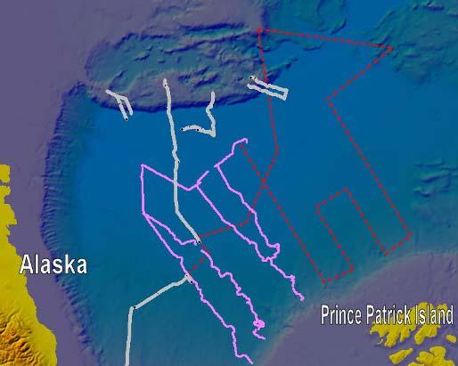
10 Bathymetric data coverage Alaska blue: spot soundings green: US & UK nuclear submarines ( ) red: SCICEX nuclear submarine ( ) Greenland IBCAO 2000

11 Bathymetric data coverage Alaska IBCAO 2008
12 Costs Icebreakers: $65000 to $85000 / Day Aircraft: $1300 to $12500 / Hour; Minimums 3-4 Hr / Day Fuel: Diesel $ $2.50 / L 1-2 Million L per Icebreaker per Summer Survey Jet Fuel Resolute: $2.50 / L by sea; $7 / L by air Eureka: $3.50 / L by sea; $8 / L by air Alert: $10 / L by air Ice Camp: $14 - $20 / L by air 300, ,000 L per Winter Survey Air freight: $ 50 per Kg to Resolute by air $ to $60000 Charter to Ocean Canada and Denmark have launched expensive data acquisition programs
13 Operational Strategies Desk Top studies form the basis for data collection strategy: On-ice test of appurtenance using refraction seismic experiments Eastern part: on ice bathymetry profiles approx. 50 M apart ( ping rate from 10 km to 2 km) Icebreaker surveys in western part and where ice conditions permit for bathymetry and sediment thickness

14 Arctic Ocean Canada Complicated seafloor geology and difficult data collection Eastern Arctic (start in 2006) Western Arctic (start in 2006) EEZ Possible overlaps with USA, Russia and Denmark: need negotiations Program requires at least 5 field seasons of data collection The white zone, or part of it, could be Canada s extended continental shelf under Article 76 Concerns: weather and ice conditions/icebreaker capability

15 Arctic Ocean Greenland Possible ecs area north of Greenland based on desk top study
16 Logistical challenges No commercial survey vessels can operate in this region of the Arctic Ocean Only a few Polar Class icebreakers are available SCICEX US submarines have been decommissioned, UUV concept to be developed Specialized ice strengthened bathymetry and seismic equipment for icebreaker surveys has to be develop Former experience and equipment used in the 80 ties for on-ice surveys have aged Establishment of ice camps on more unstable sea ice Sharing of knowledge and cost through cooperation between Canada and Greenland/Denmark
17 Operational Experience Strategy Western Arctic (from North America perspective) Icebreaker Surveys Sediment Thickness Bathymetry (Foot of Slope) Eastern Arctic Ice Camps Tests of Appurtenance (Alpha & Lomonosov) Bathymetry (Foot of Slope and 2500 m isobath) Sediment Thickness Aero Gravity and Magnetics North of Greenland Icebreakers Ice Camp Aero Gravity and Magnetics

18 Ideal Plan 50 M line spacing
19 Western Arctic Multibeam Test 2005 Seismic System Test 2006 Seismic and Bathymetric Survey Km Single Beam bathymetric data 3000 Km Seismic data Seismic and Bathymetric Survey 2008 CCGS Louis S. St-Laurent / USCGC Healy 2800 Km Seismic data X km Single and Multi Beam bathymetric data Plan Work Towards East to Limit of Icebreaker Capability

20 Deploying Air gun array (weight: 4400 pounds)

21 Using the airgun array on CCGS Louis S. St-Laurent


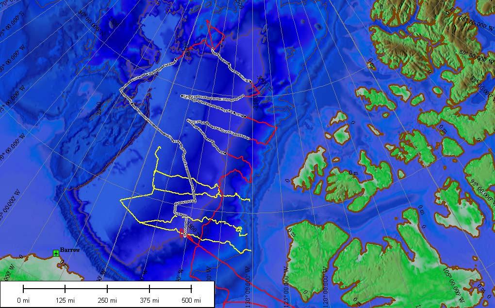
22 2007 Seismic Survey Plan - achieved Alaska Greenland Light ice sediment Heavy ice Heavy ice in eastern area Light ice in western area 3000 km excellent seismic data 7800 km Bathymetric data basement Alaska Banks I.

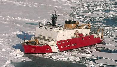
23 2008 Plan CCGS Louis S. St-Laurent USCGC Healy

24 2008 Plan - achieved

25 Web-cam on Healy Louis S. St. Laurent breaking ice Healy acquisition of multibeam data Beaufort Sea September 2008
26
27 Eastern Arctic Lomonosov Test of Appurtenance 2006 Bathymetric Survey Spring 2007 Seismic & Bathy Survey LOMROG 2007 Alpha Ridge Test of Appurtenance 2008 Planned: Bathy North Ellesmere Island and Greenland Spring 2009 Bathy and Seismic Lomonosov Summer 09 and 11 Use of UUV s (?)

28 Eastern Arctic: Natural prolongation of submarine ridges/elevations Collaboration with Denmark MOU with Denmark (June 2005) for joint surveying in area north of Greenland / Ellesmere Island Saves Canada & Denmark $ 1.5 million Other advantages: joint data collection and interpretation Project LORITA March 2006 (Lomonosov Ridge Test of Appurtenance) On ice experiment


29 LORITA Lomonosov Ridge Test of Appurtenance Planned Achieved


30 LORITA Refraction seismic experiment on sea ice

31 CHS Bathy Plan in March April 2007


32 CHS Bathy Plan in March April 2007 A B A drainage of sea ice from the Lincoln Sea trough the Nares Strait. B Helicopters with no horizon in spring of 2007 data acquisition not possible..
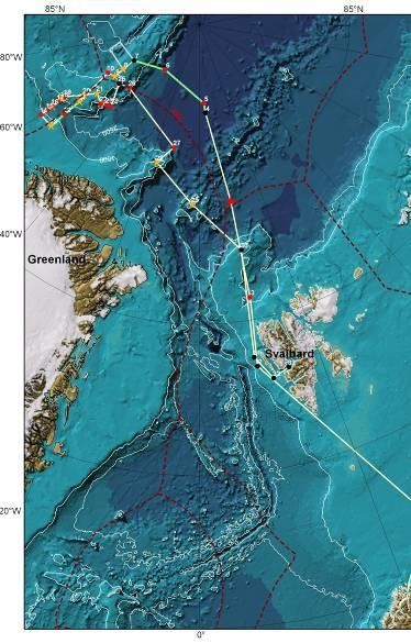
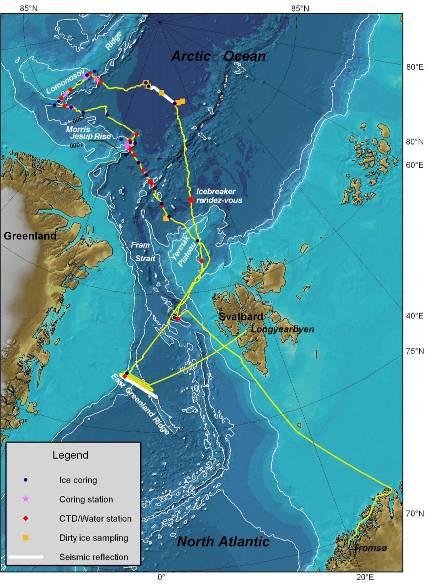
33 LOMROG: August-September 2007 ACHIEVED PLANED


34 LOMROG: Ice conditions August 1, 2007 September 30, 2007


35 LOMROG: Seismic equipment Airgun Seismic streamer Winch Recording container


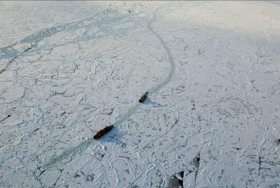
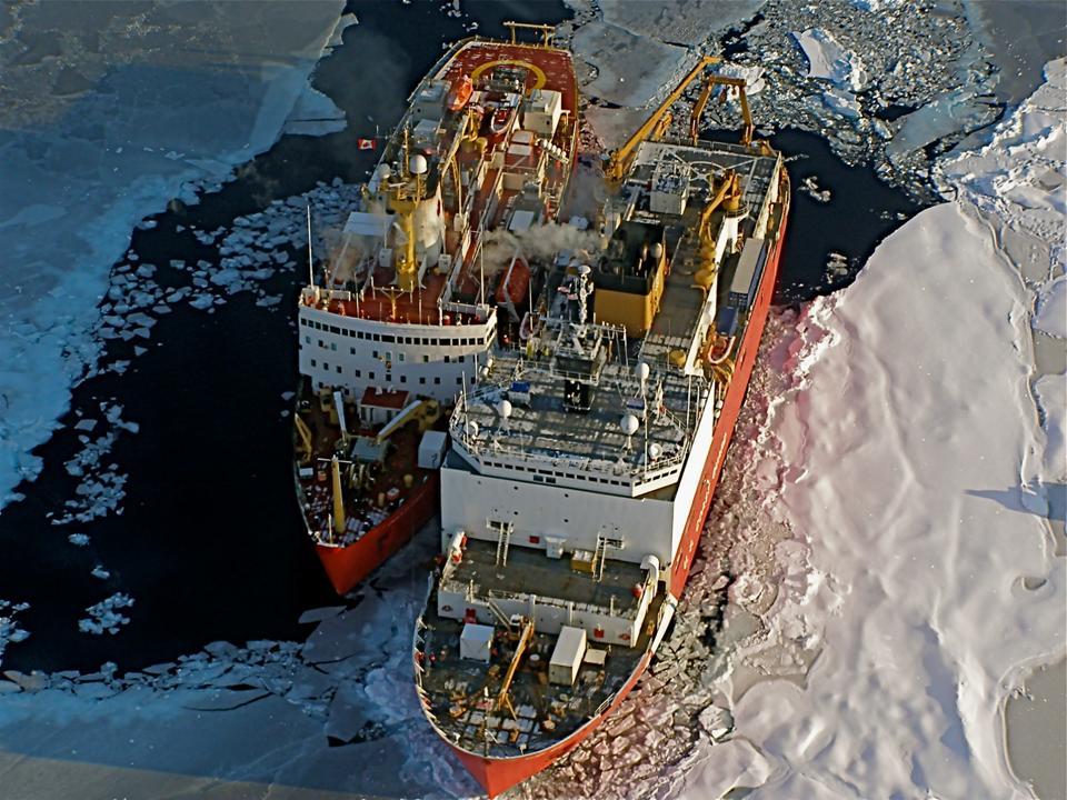
36 LOMROG: Ice Escort 50 Let Pobedy and Oden

37 LOMROG: Ice Escort 50 Let Pobedy and Oden

38 LOMROG: The Occasional Snag Seismic streamer caught in heavy sea ice


39 LOMROG: Multi beam acquisition Pirouette surveying 3D-view of the multi beam mapped Morris Jesup Rise north of Greenland
40 ARTA in 2008: Alpha Ridge Test of Appurtenance Staged from Eureka Fuel & Gear into Eureka by Icebreaker Ice Camp - ideally 200 NM offshore (need foot ice runway Not Found) 5 Helicopters 1-2 Twin Otters DC-3 and Buffalo for Camp in / out Two refractionseismic lines LORITA concept Bathymetric profiles ~ 50 M apart


41 ARTA in 2008: Planned and revised survey area March 9 March 15

42 ARTA in 2008: Ice conditions

43 ARTA in 2008: Camp and runway Photos of landfast ice and camp with 900 meter ice runway at entrance of Nansen Sound.


44 ARTA in 2008: Sounding and Gravity Measurements

45 ARTA in 2008: Acquired data
46 Conclusions Risk of Losing a Season due to Remoteness, changing ice conditions and weather are high. Straight Lines and Continuous Profiles are a challenge especially in 10/10 ice. Existing Data supplemented by space and airborne Gravity and ground-truthed where practical will be important. Possible use of new technology UUV. Opportunity for Cooperation & Joint Projects.
47 THANKS!
Operating conditions in the Arctic: Data acquisition in the Arctic Ocean by the Continental Shelf Project of the Kingdom of Denmark
 Operating conditions in the Arctic: Data acquisition in the Arctic Ocean by the Continental Shelf Project of the Kingdom of Denmark By Christian Marcussen Geological Survey of Denmark and Greenland Danish
Bathymetric data acquisition in Arctic waters
 Bathymetric data acquisition in Arctic waters within the Danish Continental Shelf Project Morten Sølvsten, Uni Bull, Richard Pedersen & Christian Marcussen Arctic-Antarctic Seafloor Mapping Meeting 2011
The Continental Shelf Project: An overview of research activities in the Arctic Ocean on behalf of the Kingdom of Denmark
 The Continental Shelf Project: An overview of research activities in the Arctic Ocean on behalf of the Kingdom of Denmark Geological Survey of Denmark and Greenland Ministry of Climate and Energy John
Seafloor Mapping in the High Arctic: The Challenges and the Joys
 Seafloor Mapping in the High Arctic: The Challenges and the Joys Larry Mayer Center for Coastal and Ocean Mapping / NOAA- UNH Joint Hydrographic Center University of New Hampshire, USA Martin Jakobsson
Buoy deployment by the ice breaker USCG Healy
 Enhancements of the Arctic Buoys for the International Polar Year Buoy deployment by the ice breaker USCG Healy Buoys-on-Ice 2007 a success: Deployment flights 26 and 29 March o Flying hours funded by
Glaciology Exchange (Glacio-Ex) Norwegian/Canadian/US Partnership Program
 Norwegian/Canadian/US Partnership Program") Glaciology Exchange (Glacio-Ex) Norwegian/Canadian/US Partnership Program Luke Copland University of Ottawa, Canada Jon Ove Hagen University of Oslo, Norway Kronebreeen, Svalbard. Photo: Monica Sund The
Glaciology Exchange (Glacio-Ex) Norwegian/Canadian/US Partnership Program Luke Copland University of Ottawa, Canada Jon Ove Hagen University of Oslo, Norway Kronebreeen, Svalbard. Photo: Monica Sund The
Non-Technical Summary
 Non-Technical Summary Proposed Project TGS-NOPEC Geophysical Company ASA (TGS) proposes to undertake a two dimensional (2D) seismic survey and seabed sampling in the western Greenland Sea off North East
Sea-ice change around Alaska & Impacts on Human Activities
 Sea-ice change around Alaska & Impacts on Human Activities Hajo Eicken Geophysical Institute University of Alaska Fairbanks, hajo.eicken@gi.alaska.edu Introduction The Arctic sea-ice cover: Observations
THE MEASUREMENT AND ANALYSIS OF BATHYMETRY, MORPHOLOGY, AND SEDIMENT THICKNESS
 THE MEASUREMENT AND ANALYSIS OF BATHYMETRY, MORPHOLOGY, AND SEDIMENT THICKNESS Ron Macnab Geological Survey of Canada (Retired) OUTLINE OF PRESENTATION Principles and practice of: Echo-sounding Seismic
Canadian Ice Service
 Canadian Ice Service Key Points and Details concerning the 2009 Arctic Minimum Summer Sea Ice Extent October 1 st, 2009 http://ice-glaces.ec.gc.ca 1 Key Points of Interest Arctic-wide The Arctic-wide minimum
UNCLOS Article 76- Formulae and constraint lines
 UNCLOS Article 76- Formulae and constraint lines Dr Lindsay Parson (UNCLOS Group, National Oceanography Centre, UK) ABLOS TUTORIAL SESSION - Article 76 of UNCLOS 10th October 2005 IHO/IAG/IOC Advisory
COMPLICATIONS IN DELIMITING THE OUTER CONTINENTAL SHELF. Ron Macnab Geological Survey of Canada (Retired)
") COMPLICATIONS IN DELIMITING THE OUTER CONTINENTAL SHELF Ron Macnab Geological Survey of Canada (Retired) DISCLAIMER The contents of this presentation are the author s personal views only, and do not represent
COMPLICATIONS IN DELIMITING THE OUTER CONTINENTAL SHELF Ron Macnab Geological Survey of Canada (Retired) DISCLAIMER The contents of this presentation are the author s personal views only, and do not represent
The Arctic - A New Frontier The geological, environmental and engineering challenges for submarine telecommunication cables
 The Arctic - A New Frontier The geological, environmental and engineering challenges for submarine telecommunication cables Ryan Wopschall 5 September 2013 Oceanology International China, Shanghai Fugro
The french national programme for claiming continental shelf beyond 200 Miles
 The french national programme for claiming continental shelf beyond 200 Miles Using global bathymetric models in the context of an Extended Continental Shelf submission EXTRAPLAC Using Global Bathymetric
Outline of presentation
 - lessons learnt from precedent cases of establishing the s Outline of presentation Extending Ireland s continental shelf jurisdiction to the outer s in the Porcupine Abyssal Plain: progress, issues and
I. PURPOSE. This White Paper describes the role(s), value, and preparation requirements for a
, value, and preparation requirements for a") USE OF A SUBMARINE IN ICE-COVERED ARCTIC WATERS TO HELP DELIMIT THE U.S. EXTENDED CONTINENTAL SHELF (Draft White Paper from the U.S. Arctic Research Commission) (Rev. 12-18-07) I. PURPOSE. This White Paper
USE OF A SUBMARINE IN ICE-COVERED ARCTIC WATERS TO HELP DELIMIT THE U.S. EXTENDED CONTINENTAL SHELF (Draft White Paper from the U.S. Arctic Research Commission) (Rev. 12-18-07) I. PURPOSE. This White Paper
Korean Arctic Research 2015 update
 FARO Annual Meeting, ASSW 2016 Fairbanks, Alaska, 12 March 2016 Korean Arctic Research 2015 update International Cooperation Department Korea Polar Research Institute Outline KOPRI and Korean Arctic research;
British Colombia Knight Inlet Strait of Georgia Strait of Juan de Fuca
 An Atlas of Oceanic Internal Solitary Waves (February 2004) Knight Inlet Strait of Georgia Strait of Juan de Fuca Overview Knight Inlet, the Strait of Georgia and the Strait of Juan de Fuca are all shallow
The Arctic Sea Ice Cover
 The Arctic Sea Ice Cover From the Living Earth Interface, Impediment, Integrator Frozen ocean 8-15 million km 2 Size of U.S. Meters thick Floating, moving ice Highly variable Large albedo Climate change!
EC-PORS III Research. Sodankylä, February Developing a Polar Prediction System
 EC-PORS III Research Sodankylä, February 2012 Developing a Polar Prediction System Polar Prediction System - Status 1. EC-PORS I (Oct. 2009) -> initial discussions 2. WWRP/THORPEX Polar Prediction Workshop,
OUTER CONTINENTAL SHELF CLAIMS IN THE ARCTIC. Presentation given by Dr. Kamrul Hossain ASA University Bangladesh 15 March 2010
 OUTER CONTINENTAL SHELF CLAIMS IN THE ARCTIC Presentation given by Dr. Kamrul Hossain ASA University Bangladesh 15 March 2010 Contents Historical background of the continental shelf Concept of continental
46ºN to 75ºN (Quebec City to the Beaufort Sea): 2011 Ocean Mapping Group Operations in the Canadian Arctic, Part III. By Doug Cartwright
: 2011 Ocean Mapping Group Operations in the Canadian Arctic, Part III. By Doug Cartwright") 46ºN to 75ºN (Quebec City to the Beaufort Sea): 2011 Ocean Mapping Group Operations in the Canadian Arctic, Part III By Doug Cartwright Doug Cartwright, Christine Legere and Pim Kuus met up with the CCGS
46ºN to 75ºN (Quebec City to the Beaufort Sea): 2011 Ocean Mapping Group Operations in the Canadian Arctic, Part III By Doug Cartwright Doug Cartwright, Christine Legere and Pim Kuus met up with the CCGS
Proposed travel plan and timing
 Proposed travel plan and timing Figure 1: Proposed GLACE cruise track. The circumnavigation of Greenland will be subdivided into 2 Legs: Leg 1 (Southern Greenland, SG) from Reykjavik to Ilulisat, and Leg
Figure 3.1: Illustration showing the bathymetry s role for the tsunami propagation following the earth quake 26 December 2004 outside of Sumatra.
 Figure 3.1: Illustration showing the bathymetry s role for the tsunami propagation following the earth quake 26 December 2004 outside of Sumatra. The left globe shows the seafloor bathymetry as portrayed
Canadian activities in the Pacific Arctic Region: 2016 icebreaker plans.
 Canadian activities in the Pacific Arctic Region: 2016 icebreaker plans. Pacific Arctic Group meeting Arctic Science Summit Week, Fairbanks, Alaska 13 March 2016 CCGS Louis S. St-Laurent UNCLOS misson:
Changing Marine Access in the Arctic Ocean: The Arctic Climate Impact Assessment Panama Canal Authority 11 January 2005
 Changing Marine Access in the Arctic Ocean: The Arctic Climate Impact Assessment Panama Canal Authority 11 January 2005 Lawson Brigham Deputy Director, U.S. Arctic Research Commission ACIA Contributing
Chapter Overview. Bathymetry. Measuring Bathymetry. Measuring Bathymetry
 CHAPTER 3 Marine Provinces Chapter Overview The study of bathymetry determines ocean depths and ocean floor topography. Echo sounding and satellites are efficient bathymetric tools. Most ocean floor features
Observing Arctic Sea Ice Change. Christian Haas
 Observing Arctic Sea Ice Change Christian Haas Decreasing Arctic sea ice extent in September Ice extent is decreasing, but regional patterns are very different every year The Cryosphere Today, http://arctic.atmos.uiuc.edu;
Acoustic Thermometry in the Arctic Ocean. Peter Mikhalevsky Acoustic and Marine Systems Operation Science Applications International Corporation
 Acoustic Thermometry in the Arctic Ocean following following Ira to the Arctic Peter Mikhalevsky Acoustic and Marine Systems Operation Science Applications International Corporation Ira Dyer Symposium
The Arctic Cold War The battle to control resources while the future of the earth hangs in the balance.
 The Arctic Cold War The battle to control resources while the future of the earth hangs in the balance. 1 The Arctic Cold War The battle to control resources while the future of the earth hangs in the
German Arctic Expeditions
 German Arctic Expeditions 2015-2016 FARO/ASSW, 2016, Fairbanks Dirk Mengedoht (Alfred Wegener Institute, Germany) Dirk Mengedoht, AWI Logistics 2015 Polarstern Arctic Expeditions 2015 Leg Start End Mission
Bathymetry Measures the vertical distance from the ocean surface to mountains, valleys, plains, and other sea floor features
 1 2 3 4 5 6 7 8 9 10 11 CHAPTER 3 Marine Provinces Chapter Overview The study of bathymetry determines ocean depths and ocean floor topography. Echo sounding and satellites are efficient bathymetric tools.
Relationship Between Ice-Management
 ARCTIC Relationship Between Ice-Management and dstation ti Keeping in Ice Åke Rohlén TransAtlantic October 13-14, 2009 Return to Session Directory Relationship between Ice-Management and Station keeping
Map shows 3 main features of ocean floor
 Map shows 3 main features of ocean floor 2017 Pearson Education, Inc. Chapter 3 Marine Provinces 2017 Pearson Education, Inc. 1 Chapter 3 Overview The study of bathymetry determines ocean depths and ocean
Figure 3.1: Illustration showing the bathymetry s role for the tsunami propagation following the earth quake 26 December 2004 outside of Sumatra.
 Figure 3.1: Illustration showing the bathymetry s role for the tsunami propagation following the earth quake 26 December 2004 outside of Sumatra. The left globe shows the seafloor bathymetry as portrayed
CANADIAN HYDROGRAPHIC SERVICE & OCEANOGRAPHIC SERVICES
 CANADIAN HYDROGRAPHIC SERVICE & OCEANOGRAPHIC SERVICES Presentation to Warming of the North Conference Ottawa, March 2 nd, 2015 Denis Hains, Director General & Hydrographer General of Canada TIP OF THE
Tutorial on Methane Hydrate. Presented by Ad Hoc Group on Methane Hydrate Research March 24, 2004
 Tutorial on Methane Hydrate Presented by Ad Hoc Group on Methane Hydrate Research March 24, 2004 Tutorial on Methane Hydrate What is it and how is it formed? Where is it found? How much may exist? Multi-National
TEACHER PAGE Trial Version
 TEACHER PAGE Trial Version * After completion of the lesson, please take a moment to fill out the feedback form on our web site (https://www.cresis.ku.edu/education/k-12/online-data-portal)* Lesson Title:
CONFERENCE OF PARLIAMENTARIANS OF THE ARCTIC REGION. UN LOS Convention and the extended continental shelf in the Arctic
 CONFERENCE OF PARLIAMENTARIANS OF THE ARCTIC REGION UN LOS Convention and the extended continental shelf in the Arctic Presentation given by Dr. Kamrul Hossain Finnish Parliament 18 November 2009 Contents
SW Florida Escarpment Mapping Area
 Overview NOAA s Okeanos Explorer (EX) Program plans to conduct systematic mapping and telepresence-enabled ROV explorations in the Gulf of Mexico during Spring 2014. In 2011, the EX conducted mapping operations
Distribution and Thickness of Different Sea Ice Types and Extreme Ice Features in the Beaufort Sea: 2012 Field Report
 Distribution and Thickness of Different Sea Ice Types and Extreme Ice Features in the Beaufort Sea: 2012 Field Report July 2012 NCR#5859681 - v1 DISTRIBUTION AND THICKNESS OF DIFFERENT SEA ICE TYPES AND
The importance of long-term Arctic weather station data for setting the research stage for climate change studies
 The importance of long-term Arctic weather station data for setting the research stage for climate change studies Taneil Uttal NOAA/Earth Systems Research Laboratory Boulder, Colorado Things to get out
Global Atmospheric Circulation
 Global Atmospheric Circulation Polar Climatology & Climate Variability Lecture 11 Nov. 22, 2010 Global Atmospheric Circulation Global Atmospheric Circulation Global Atmospheric Circulation The Polar Vortex
U.S. Coast Guard Polar Icebreaker Program
 U.S. Coast Guard Polar Icebreaker Program November 2003 USCG Polar Icebreaker Program Update USCG Polar Ice OPs Program History 1885 Cutter Bear explores Alaskan waters for 40 years 1965-66 1950 s Joint
Geophysical Journal International
 Geophysical Journal International Geophys. J. Int. (2010) 182, 11 35 doi: 10.1111/j.1365-246X.2010.04604.x Sedimentary and crustal structure from the Ellesmere Island and Greenland continental shelves
CONTINENTAL SHELF SUBMISSION OF ANGOLA - EXECUTIVE SUMMARY -
 CONTINENTAL SHELF SUBMISSION OF ANGOLA - EXECUTIVE SUMMARY - INDEX List of Figures 2 List of Tables 3 1 Introduction 5 2 Provisions of Article 76 7 3 Angolan Institutions responsible for the Submission
Impact of changing Siberian land-shelf-basin on the Arctic Ocean biogeochemical dynamics
 Impact of changing Siberian land-shelf-basin on the Arctic Ocean biogeochemical dynamics PI: Shigeto Nishino (JAMSTEC) Co-PI: Igor Semiletov (IARC/UAF) Other Investigators: Natalia Shakhova (IARC/UAF),
HANS ISLAND / TARTUPALUK A year of meteorological measurements
 HANS ISLAND / TARTUPALUK A year of meteorological measurements J.P. Wilkinson, P. Gudmandsen, S. Hanson, R. Saldo, R.M. Samelson, D. Barber, H. Melling, D. Mercer + many more Where is it? http://upload.wikimedia.org/wikipedia/commons/f/f8/nares_strait_border_(kennedy_channel).png
North Pacific Climate Overview N. Bond (UW/JISAO), J. Overland (NOAA/PMEL) Contact: Last updated: August 2009
, J. Overland (NOAA/PMEL) Contact: Last updated: August 2009") North Pacific Climate Overview N. Bond (UW/JISAO), J. Overland (NOAA/PMEL) Contact: Nicholas.Bond@noaa.gov Last updated: August 2009 Summary. The North Pacific atmosphere-ocean system from fall 2008 through
North Pacific Climate Overview N. Bond (UW/JISAO), J. Overland (NOAA/PMEL) Contact: Nicholas.Bond@noaa.gov Last updated: August 2009 Summary. The North Pacific atmosphere-ocean system from fall 2008 through
ARTICLE. Defining Canada s Extended Continental Shelves. GEOSCIENCE CANADA Volume 38 Number 2 June
 GEOSCIENCE CANADA Volume 38 Number 2 June 2011 85 ARTICLE Defining Canada s Extended Continental Shelves Jacob Verhoef 1, David Mosher 1, and Steve Forbes 2 1 Geological Survey of Canada Natural Resources
ARICE Arctic Research Icebreaker Consortium for Europe A strategy for meeting the needs for marine research in the Arctic
 ARICE Arctic Research Icebreaker Consortium for Europe ARICE Arctic Research Icebreaker Consortium for Europe A strategy for meeting the needs for marine research in the Arctic 20 partners from Europe,
MAPS AND COORDINATES...
 Table of Contents 1 INTRODUCTION... 2 2 MAPS AND COORDINATES... 3 3 ADVISORY ASSISTANCE FROM COMMISSION MEMBERS... 3 4 PROVISIONS OF ARTICLE 76 INVOKED... 3 5 OUTSTANDING MARITIME DELIMITATIONS... 4 6
Spectral Albedos. a: dry snow. b: wet new snow. c: melting old snow. a: cold MY ice. b: melting MY ice. d: frozen pond. c: melting FY white ice
 Spectral Albedos a: dry snow b: wet new snow a: cold MY ice c: melting old snow b: melting MY ice d: frozen pond c: melting FY white ice d: melting FY blue ice e: early MY pond e: ageing ponds Extinction
Outline 23: The Ice Ages-Cenozoic Climatic History
 Outline 23: The Ice Ages-Cenozoic Climatic History Continental Glacier in Antarctica Valley Glaciers in Alaska, note the moraines Valley Glaciers in Alaska, note the moraines Mendenhall Glacier, Juneau,
Highlights of the 2006 Water Year in Colorado
 Highlights of the 2006 Water Year in Colorado Nolan Doesken, State Climatologist Atmospheric Science Department Colorado State University http://ccc.atmos.colostate.edu Presented to 61 st Annual Meeting
Regional Outlook for the Bering-Chukchi-Beaufort Seas Contribution to the 2018 Sea Ice Outlook
 Regional Outlook for the Bering-Chukchi-Beaufort Seas Contribution to the 2018 Sea Ice Outlook 25 July 2018 Matthew Druckenmiller (National Snow and Ice Data Center, Univ. Colorado Boulder) & Hajo Eicken
FINMARINET: Inventories and Planning for the Marine Natura 2000 Network in Finland. A.2 Geological inventories of the seafloor Final Report
 LIFE07 NAT/FIN/000151 FINMARINET: Inventories and Planning for the Marine Natura 2000 Network in Finland A.2 Geological inventories of the seafloor Final Report Geological Survey of Finland, GTK 1. Introduction
Catastrophic reduction of seaice in the Arctic Ocean - its impact on the marine ecosystems in the polar region-
 1/12 Catastrophic reduction of seaice in the Arctic Ocean - its impact on the marine ecosystems in the polar region- KAKENHI No.22221003 Naomi Harada (JAMSTEC) J. Onodera, E. Watanabe, K. Matsuno, K. Kimoto,
FEATURES OF TERRIGEN1C MATERIAL TRANSPORT BY ICE IN POLAR SEDIMENTATION
 G. A. Tar aso v Murmansk Marine Biological Institute of the Russian Academy of Sciences Robert Spielhagen GEO MOR, Kiel Hannes Grobe Alfred-Wegener-Institute for Polar and Marine Research, Bremerhaven
Appendix E: Oceanographic Databases
 Appendix E: Oceanographic Databases Many of the principal U.S. and international database depositories for worldwide ocean observations are listed below, as are a few technical reports with descriptions
Correction to Evaluation of the simulation of the annual cycle of Arctic and Antarctic sea ice coverages by 11 major global climate models
 JOURNAL OF GEOPHYSICAL RESEARCH, VOL. 111,, doi:10.1029/2006jc003949, 2006 Correction to Evaluation of the simulation of the annual cycle of Arctic and Antarctic sea ice coverages by 11 major global climate
Legal Interpretation of Submarine Ridges & Submarine Elevations
 Legal Interpretation of Ridges & Article 76, paragraph 6 New Knowledge and Changing Circumstances in the Law of the Sea Reykjavik, Iceland June 28, 2018 Kevin Baumert U.S. Department of State U.S. ECS
Ice and Ocean Mooring Data Statistics from Barrow Strait, the Central Section of the NW Passage in the Canadian Arctic Archipelago
 Ice and Ocean Mooring Data Statistics from Barrow Strait, the Central Section of the NW Passage in the Canadian Arctic Archipelago Simon Prinsenberg and Roger Pettipas Bedford Institute of Oceanography,
Sea Ice Prediction Network (SIPN) Webinar: Industry Needs for Seasonal and Sub-seasonal Sea Ice Information and Predictions
 Webinar: Industry Needs for Seasonal and Sub-seasonal Sea Ice Information and Predictions") Sea Ice Prediction Network (SIPN) Webinar: Industry Needs for Seasonal and Sub-seasonal Sea Ice Information and Predictions Hajo Eicken International Arctic Research Center University of Alaska Fairbanks,
Sea Ice Prediction Network (SIPN) Webinar: Industry Needs for Seasonal and Sub-seasonal Sea Ice Information and Predictions Hajo Eicken International Arctic Research Center University of Alaska Fairbanks,
Arctic sea ice falls below 4 million square kilometers
 SOURCE : http://nsidc.org/arcticseaicenews/ Arctic sea ice falls below 4 million square kilometers September 5, 2012 The National Snow and Ice Data Center : Advancing knowledge of Earth's frozen regions
Office of Naval Research Arctic Observing Activities
 Office of Naval Research Arctic Observing Activities Jim Thomson Applied Physics Laboratory, University of Washington jthomson@apl.washington.edu Scott L. Harper, Program Officer, Arctic and Global Prediction
Fire Weather Drivers, Seasonal Outlook and Climate Change. Steven McGibbony, Severe Weather Manager Victoria Region Friday 9 October 2015
 Fire Weather Drivers, Seasonal Outlook and Climate Change Steven McGibbony, Severe Weather Manager Victoria Region Friday 9 October 2015 Outline Weather and Fire Risk Environmental conditions leading to
Prepared by the North American Ice Service. 4 December Seasonal Outlook Great Lakes Winter
 Prepared by the North American Ice Service A collaboration of the Canadian Ice Service and the National/Naval Ice Center 4 December 2008 Seasonal Outlook Great Lakes Winter 2008-2009 - 1 - Table of contents
APPENDIX B PHYSICAL BASELINE STUDY: NORTHEAST BAFFIN BAY 1
 APPENDIX B PHYSICAL BASELINE STUDY: NORTHEAST BAFFIN BAY 1 1 By David B. Fissel, Mar Martínez de Saavedra Álvarez, and Randy C. Kerr, ASL Environmental Sciences Inc. (Feb. 2012) West Greenland Seismic
Iceland. Licensing of the Dreki Area. Thorarinn Arnarson
 Iceland Licensing of the Dreki Area Thorarinn Arnarson Stavanger 6 June 2011 Presentation topics Licensing Environmental conditions Geological and geophysical data Second Icelandic licensing round northern
Exemplar for Internal Achievement Standard. Mathematics and Statistics Level 3
 Exemplar for internal assessment resource Mathematics and Statistics for Achievement Standard 91580 Exemplar for Internal Achievement Standard Mathematics and Statistics Level 3 This exemplar supports
Arctic Resource Potential and Development Challenges
 Arctic Resource Potential and Development Challenges Jed Hamilton Senior Arctic Consultant ExxonMobil Upstream Research Company Houston, Texas, USA Presented at In Search of Arctic Energy Forum Sponsored
Airborne sea ice thickness sounding
 Airborne sea ice thickness sounding 1, Christian Haas 2, Lasse Rabenstein 1, John Lobach 3 1. Alfred Wegener Institute for Polar and Marine Research, Germany 2. University of Alberta, Canada 3. Ferra Dynamics
Coastal Ocean Circulation Experiment off Senegal (COCES)
") DISTRIBUTION STATEMENT A. Approved for public release; distribution is unlimited. Coastal Ocean Circulation Experiment off Senegal (COCES) Pierre-Marie Poulain Istituto Nazionale di Oceanografia e di Geofisica
DISTRIBUTION STATEMENT A. Approved for public release; distribution is unlimited. Coastal Ocean Circulation Experiment off Senegal (COCES) Pierre-Marie Poulain Istituto Nazionale di Oceanografia e di Geofisica
Office of Naval Research Update and Status of Arctic Environmental Programs
 Office of Naval Research Update and Status of Arctic Environmental Programs October 2017 CDR Blake McBride Deputy, Ocean, Atmosphere and Space Research Division Office of Naval Research marvin.mcbride@navy.mil
SEISMIC DATA ACQUISITION IN THE NANSEN BASIN, ARCTIC OCEAN
 SEISMIC DATA ACQUISITION IN THE NANSEN BASIN, ARCTIC OCEAN Øyvind Engen, Department of Geosciences, University of Oslo, P.O. Box 1047 Blindern, N-0316 Oslo, Norway oyvind.engen@geo.uio.no Jakob Andreas
Digital Elevation Model (DEM) of Sable Island Bank and adjacent areas
 of Sable Island Bank and adjacent areas") GEOLOGICAL SURVEY OF CANADA OPEN FILE 5348 Digital Elevation Model (DEM) of Sable Island Bank and adjacent areas K.J. Webb and E.L. King 2014 GEOLOGICAL SURVEY OF CANADA OPEN FILE 5348 Digital Elevation
GEOLOGICAL SURVEY OF CANADA OPEN FILE 5348 Digital Elevation Model (DEM) of Sable Island Bank and adjacent areas K.J. Webb and E.L. King 2014 GEOLOGICAL SURVEY OF CANADA OPEN FILE 5348 Digital Elevation
These%slides%are%provided%for%your% reference.%% % If%you%wish%to%use%any%slides%or% images%please%contact%the% appropriate%presenter%first%for%
 These%slides%are%provided%for%your% reference.%% % If%you%wish%to%use%any%slides%or% images%please%contact%the% appropriate%presenter%first%for% a:ribu
Does Ascension Island have an outer continental shelf?
 Does Ascension Island have an outer continental shelf? Robin Cleverly UK Hydrographic Office Lindsay Parson NOC, Southampton (with Alan Evans, Peter Hunter, Rosemary Edwards of NOC and Chris Carleton of
ARE YOU READY TO THINK? Look at the first slide THINK PAIR SHARE!
 ARE YOU READY TO THINK? Look at the first slide THINK PAIR SHARE! WHAT PROMINENT FEATURE CAN YOU IDENTIFY IN THIS PICTURE? What do you think the different colors represent? Who might find such a picture
Explain the impact of location, climate, natural resources, and population distribution on Europe. a. Compare how the location, climate, and natural
 SS6G10 Explain the impact of location, climate, natural resources, and population distribution on Europe. a. Compare how the location, climate, and natural resources of Germany, the United Kingdom and
THE FLOOR OF THE ARCTIC OCEAN: GEOGRAPHIC NAMES
 Commentary THE FLOOR OF THE ARCTIC OCEAN: GEOGRAPHIC NAMES M. A. Beall, F. Edvalson2, K. Hunkins3, A. Molloyl, and N. Ostenso4 HE NAMING OF OCEAN FLOOR features in the Arctic seems to have been done T
Recent developments in multi-beam echo-sounder processing at the Delft
 Recent developments in multi-beam echo-sounder processing at the Delft University of Technology Prof. Dr. Dick G. Simons Acoustic Remote Sensing Group, Faculty of Aerospace Engineering, Delft University
Investigation of Arctic ice cover variance using XX century historical ice charts information and last decades microwave data
 Investigation of Arctic ice cover variance using XX century historical ice charts information and last decades microwave data Vasily Smolyanitsky, Arctic and Antarctic Research Institute & JCOMM Expert
Joint Hydrographic Center, National Oceanic and Atmospheric Administration, Durham, NH 03824, USA
 Future directions in hydrography using satellite-derived bathymetry Shachak Pe eri 1, Christopher Parrish 2, 3, Lee Alexander 1, Chukwuma Azuike 1, Andrew Armstrong 1,3 and Maryellen Sault 2 1 Center for
Mass balance of sea ice in both hemispheres Airborne validation and the AWI CryoSat-2 sea ice data product
 Mass balance of sea ice in both hemispheres Airborne validation and the AWI CryoSat-2 sea ice data product Stefan Hendricks Robert Ricker Veit Helm Sandra Schwegmann Christian Haas Andreas Herber Airborne
Ice Observations on the Churchill River using Satellite Imagery
 CGU HS Committee on River Ice Processes and the Environment 15 th Workshop on River Ice St. John s, Newfoundland and Labrador, June 15-17, 2009 Ice Observations on the Churchill River using Satellite Imagery
Visible and Thermal Imaging of Sea Ice and Open Water from Coast Guard Arctic Domain Awareness Flights
 DISTRIBUTION STATEMENT A. Approved for public release; distribution is unlimited. Visible and Thermal Imaging of Sea Ice and Open Water from Coast Guard Arctic Domain Awareness Flights Ronald Lindsay Applied
Modeling the Formation and Offshore Transport of Dense Water from High-Latitude Coastal Polynyas
 Modeling the Formation and Offshore Transport of Dense Water from High-Latitude Coastal Polynyas David C. Chapman Woods Hole Oceanographic Institution Woods Hole, MA 02543 phone: (508) 289-2792 fax: (508)
Ocean Basins, Bathymetry and Sea Levels
 Ocean Basins, Bathymetry and Sea Levels Chapter 4 Please read chapter 5: sediments for next class and start chapter 6 on seawater for Thursday Basic concepts in Chapter 4 Bathymetry the measurement of
Sea Ice Characteristics and Operational Conditions for Ships Working in the Eastern Zone of the NSR
 The Arctic 2030 Project: Feasibility and Reliability of Shipping on the Northern Sea Route and Modeling of an Arctic Marine Transportation & Logistics System 3-rd. Industry Seminar: Sea-Ice & Operational
NASA Images of Antarctica and the Arctic covered in both land and sea ice
 ICE SHELVES ACTIVITY 1: DECODING THE ROLE OF ANTARCTIC ICE IN GLOBAL CLIMATE Ice Shelves play a critical role in Antarctica, serving as a buffer between the ocean and the continental ice sheet covering
Update on Pacific Arctic Group (PAG) activities
 activities") Update on Pacific Arctic Group (PAG) activities Jacqueline Grebmeier 1 and Sung-Ho Kang 2 1 Member, PAG Executive Committee, Chesapeake Biological Laboratory, University of Maryland Center for Environmental
Update on Pacific Arctic Group (PAG) activities Jacqueline Grebmeier 1 and Sung-Ho Kang 2 1 Member, PAG Executive Committee, Chesapeake Biological Laboratory, University of Maryland Center for Environmental
Deke Arndt, Chief, Climate Monitoring Branch, NOAA s National Climatic Data Center
 Thomas R. Karl, L.H.D., Director, NOAA s National Climatic Data Center, and Chair of the Subcommittee on Global Change Research Peter Thorne, PhD, Senior Scientist, Cooperative Institute for Climate and
U.S. Arctic Campaign Scenario
 Prepared by the NOAA Office of Ocean Exploration and Research for Nation Ocean Exploration Forum 2016: Beyond the Ships. Sea ice extent from National Snow Service Layer Credits: NOAA National Centers for
Interactions between water, ice and sediment during spring breakup at the mouth of the Mackenzie River, Northwest Territories
 Interactions between water, ice and sediment during spring breakup at the mouth of the Mackenzie River, Northwest Territories Steven M. Solomon 1, Donald L. Forbes 1, Maxime Belanger 2, Dustin Whalen 1,
Turmoil in the Global Biosphere A View from Space
 BIOTECHNO 2011 - Keynote Venice/Mestre, Italy, May 2011 Turmoil in the Global Biosphere A View from Space S. V. Nghiem 1, P. Clemente-Colón 2, I. G. Rigor 3, D. K. Perovich 4, and G. Neumann 1 1 NASA Jet
Climate Change in Newfoundland & Labrador
 Climate Change in Newfoundland & Labrador Impacts and Adaptation Newleef Conference 08 October 2015 Met-Ocean Services The Team 55 personnel; 24/7 operational weather forecast desk; Equipment technician
Watch for Week 8/9 Review Assessment
 Wednesday, October 25, 2017 Exam 2 results, key is posted on the main course website. Please check to make sure there are no errors in the scoring of the Scantron portion of the exam (note the scantron
FOOT OF THE CONTINENTAL SLOPE IN ARTICLE 76
 FOOT OF THE CONTINENTAL SLOPE IN ARTICLE 76 Vaughan Stagpoole, Institute of Geological & Nuclear Sciences, Lower Hutt, New Zealand, v.stagpoole@gns.cri.nz Ray Wood, Institute of Geological & Nuclear Sciences,