Interactions between water, ice and sediment during spring breakup at the mouth of the Mackenzie River, Northwest Territories
|
|
|
- Marjorie West
- 5 years ago
- Views:
Transcription
1 Interactions between water, ice and sediment during spring breakup at the mouth of the Mackenzie River, Northwest Territories Steven M. Solomon 1, Donald L. Forbes 1, Maxime Belanger 2, Dustin Whalen 1, Philip Marsh 3 1 Geological Survey of Canada, 2 University of Alberta, 3 Environment Canada
2 Acknowledgements Program for Energy Research and Development (PERD) Northern Energy Development MC Polar Continental Shelf Project Aurora Research Institute MGMEnergy, Shell Canada, Chevron Canada logistic support and data Partners and contractors: University of Calgary, University of Alberta, C-CORE, Aquatics Environmental, Tumichiat Outfitters Satellite imagery- ESA, CSA, University of Alaska GINA Canadian Helicopter Corporation
3 Issues and Objective Onshore gas production will lead to offshore exploration and exploitation of known offshore discoveries (pipelines) Assessment of risk to pipelines, navigation channels and infrastructure due to nearshore geohazards Ice-seabed interaction scours, shallow subsea permafrost Magnitude, extent and mechanisms of nearshore erosion and deposition Objective: Document river-mouth processes and river-ocean interactions during spring break-up.

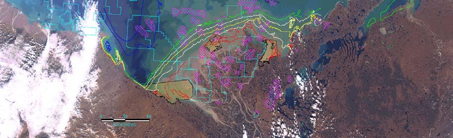
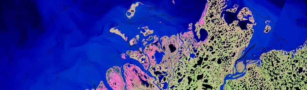
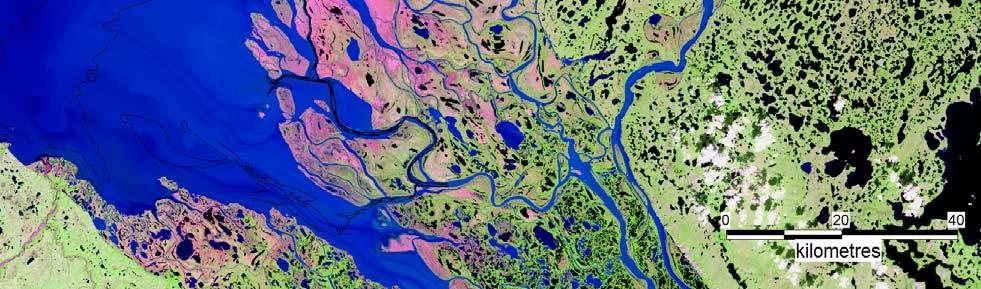
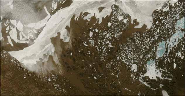
4 Study Area
5 Winter-Spring Oceanographic Environment Freeze-up in mid-late October with formation of landfast and bottom-fast ice. Continuous discharge throughout winter Development of Lake Herlinveaux fresh water ponded behind stamuki (MacDonald and Carmack) Punctuated quiescence beneath winter ice - winter surges Early-mid-May: increased river discharge prior to sea ice melt Suspended sediment concentrations up to 4 g/l SPM load enters fresh water basin Sediment may be flocculated (Droppo et al 1998) Lake Herlinveaux Mackenzie at Arctic Red River After Hill et al 2001

 plus ice constrained!")

6 Fluvial sediment delivery modes Hyperpycnal flows Require > 40 g/l if receiving water is salty, but < 1 g/l if fresh (e.g.mulder and Syvitski, 1995) Spring freshet TSS > 1g/l) plus ice constrained! Hypopycnal Homopycnal Boggs, S Principles of Sedimentology and Stratigraphy, 2nd edition, Prentice Hall Hyperpycnal
7 Methods Synthetic Aperture Radar (SAR) for mapping bottomfast ice MODIS imagery to monitor progression of breakup in near-real time Time lapse camera flood elevation and timing Water level gauges on-ice water levels Helicopter overflights and on-ice observations Sidescan sonar and depth sounding strudel scour mapping


8 Setting the stage: Winter Bottomfast Ice Development Ice Elevations ( -5.1 to -4.8 ( -5.4 to -5.1 ( -5.5 to -5.4 ( -5.6 to -5.5 ( -5.8 to -5.6 ( -6.8 to -5.8
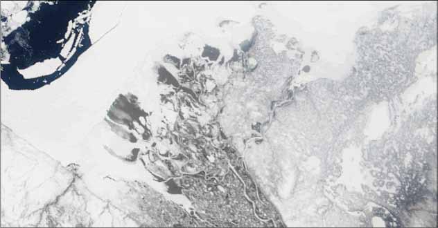
9 Bottomfast ice controls on overflow and drainage End of Winter Early breakup Mid-breakup


10 BFI influence on water flow and channel incision


11 Nearshore BFI conditions prior to breakup


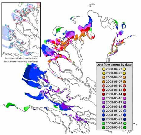
12 Spring breakup 2008 May 7, 18, 20, 22, 23, 24, 25, 30, June 4, 7, 11
13 Discharge and Overflow Timing Overflow precedes peak WL by several days to 2 weeks Overflow Initiation Overflow Max peak WL Inuvik 07- may May May May May Jun-07 Peak WL Outer delta 1-3 Jun-08 4-Jun May May May May May May May May Jun May May Jun-03

 East Channel (MD) Middle Channel at Langley (OD) Reindeer Channel (OD) Napoiak Channel (OD) West Channel (OD) East Channel (OD)")
14 Overflow sediment concentration Overflow waters variable sediment concentrations Peak freshet concentration: Lesack data 2007 peak Suspended Sediment 2008 loads exiting delta in Aug /3 5/8 5/13 5/18 5/23 5/28 6/2 6/7 6/12 6/17 6/ Mackenzie at Arctic Red Middle Channel (MD) East Channel (MD) Middle Channel at Langley (OD) Reindeer Channel (OD) Napoiak Channel (OD) West Channel (OD) East Channel (OD) Arctic Red River Peel River Peel Channel (MD) Apr May-08 1-Jun Jun Jul Jul Aug-08 9-Sep-08 Mackenzie at Arctic Red Middle Channel at Langley (OD) East Channel (OD)


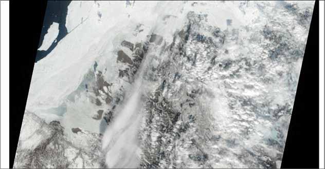
15 Initiation of Breakup Rising limb of the spring freshet Increased discharge from southern drainage basins Initiation of overflow, backwater effects Increased current velocity in ice-constrained channels? May 7, 18, 22, 2008 Local backwater effects?
16 Coastal well-site K30 looking north May 18 May 21 Backwater flooding May 31 June 3 Freshet Peak


17 Overflow water levels over ice Apr May 10-May 17-May 24-May 31-May 07-Jun 14-Jun BH4depth_corr Strudel_depth_corr Tuk_WL_24hMA


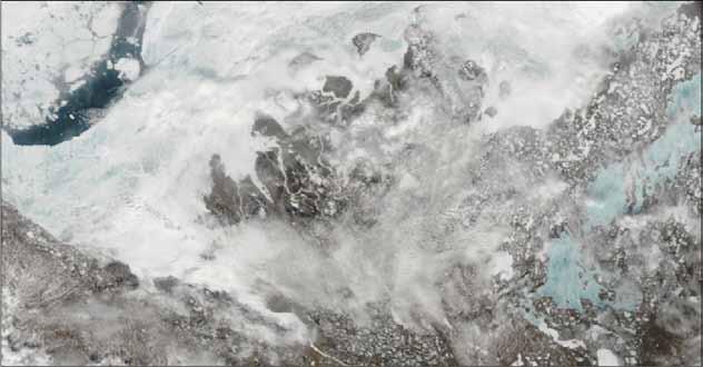
18 Overflow and upwelling May 21-22, 2008


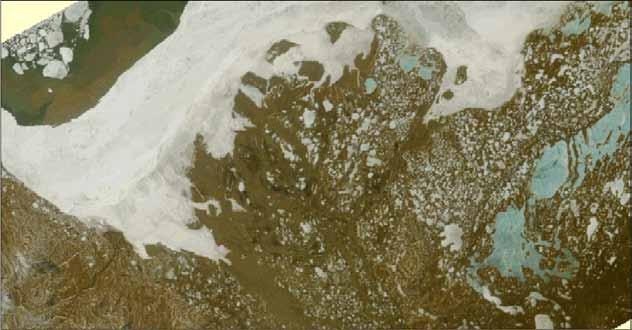
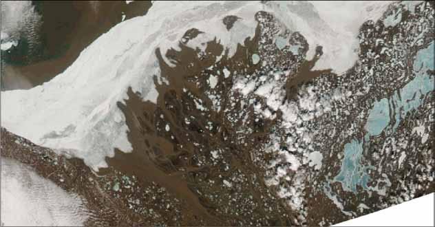
19 Strudel Drainage l l l l f gg g f l g ff g ff ff f gg gg g gg f f gggg g lll f f ff f f f f f f f f 0 5 kilometres 10

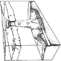
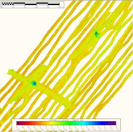
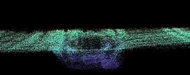
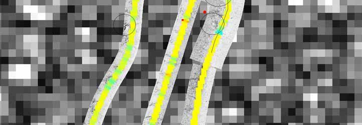
20 Strudel Scours
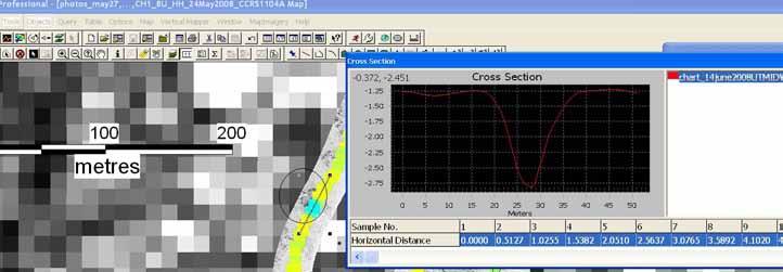
21
22 Summary and Conclusions Upwelling, overflow and strudel drainage energetic but short-lived processes precede peak discharge by several days to two weeks locations are controlled by the distribution of BFI Backwater flooding and overflow are indicators of iceconstraints at distributary mouths Timing of overflow drainage indicates removal of constraints prior to peak discharge Flow perturbations at constraints are unknown Strudel scour is extensive locations appear to be predictable Infill may occur within a single season Future: What is happening to the dirt? Erosion at ice-constrained channel mouths Behaviour of suspended materials in plume Physical modelling of strudel drainage
MACKENZIE DELTA AND BEAUFORT COAST SPRING BREAKUP NEWSLETTER
 MACKENZIE DELTA AND BEAUFORT COAST SPRING BREAKUP NEWSLETTER Report 2017-08 May 21, 2017 at 13:00 UTC Friends of Steven Solomon (Dustin Whalen, Paul Fraser, Don Forbes) Geological Survey of Canada, Bedford
Topographic LiDAR providing a new perspective in the Mackenzie Delta
 Topographic LiDAR providing a new perspective in the Mackenzie Delta D. Whalen 1, D.L. Forbes 1, C. Hopkinson 2, J.C. Lavergne 3, G.K. Manson 1, P. Marsh 4, S.M. Solomon 1 1 Geological Survey of Canada,
MACKENZIE DELTA AND BEAUFORT COAST SPRING BREAKUP NEWSLETTER
 MACKENZIE DELTA AND BEAUFORT COAST SPRING BREAKUP NEWSLETTER Report 2017-03 May 10, 2017 at 23:00 UTC Friends of Steven Solomon (Dustin Whalen, Paul Fraser, Don Forbes) Geological Survey of Canada, Bedford
Tapped lakes as sediment traps in an Arctic delta
 Sediment Dynamics from the Summit to the Sea 407 (Proceedings of a symposium held in New Orleans, Louisiana, USA, 11 14 December 2014) (IAHS Publ. 367, 2014). Tapped lakes as sediment traps in an Arctic
Sea-ice change around Alaska & Impacts on Human Activities
 Sea-ice change around Alaska & Impacts on Human Activities Hajo Eicken Geophysical Institute University of Alaska Fairbanks, hajo.eicken@gi.alaska.edu Introduction The Arctic sea-ice cover: Observations
The Wilrich Member, Alberta deep basin: An example of a topsetdominated delta deposited into a low-accommodation shallow sea.
 The Wilrich Member, Alberta deep basin: An example of a topsetdominated delta deposited into a low-accommodation shallow sea. Kerrie Bann & Michael Fawcett Ichnofacies Analysis Inc. & Tourmaline Oil Corp.
Main issues of Deltas
 Global sediment supply to coastal seas and oceans; location of major river deltas RIVER DELTAS Depositional processes - Course Coastal Morphodynamics GEO3-436; lecture 4 Nile Delta, Egypt Solo Delta, Java,
Freeze-Up Studies of the Alaskan Beaufort and Chukchi Seas: through Coastal Frontiers Corporation Vaudrey & Associates, Inc.
 Freeze-Up Studies of the Alaskan Beaufort and Chukchi Seas: 2009-10 through 2015-16 Coastal Frontiers Corporation Vaudrey & Associates, Inc. Joint-Industry Sponsors U.S. Department of the Interior Bureau
Section 2.1 Ocean Basins. - Has helped determine where ocean basins are located. - Tectonic plates move changing the position of the continents.
 Science 8 Unit 1: Water Systems on Earth Chapter 2: Oceans Control the Water Cycle Section 2.1 Ocean Basins Oceans are important because: 1. Primary water source for the water cycle 2. Control weather
Grade 8 Science. Unit 1: Water Systems on Earth Chapter 2
 Grade 8 Science Unit 1: Water Systems on Earth Chapter 2 Oceans are important... 1. Primary water source for the water cycle 2. Control weather 3. Support diverse life 4. Provides humans with food, minerals,
5. MANY COASTAL COMMUNITIES AND FACILITIES WILL FACE INCREASING EXPOSURE TO STORMS.
 5. MANY COASTAL COMMUNITIES AND FACILITIES WILL FACE INCREASING EXPOSURE TO STORMS. Climate change is altering the Arctic coastline and much greater changes are projected for the future as a result of
Sediment Transport and Strata Formation in the Adriatic Sea
 Sediment Transport and Strata Formation in the Adriatic Sea Wayne R. Geyer James D. Irish Peter A. Traykovski Woods Hole Oceanographic Institution Woods Hole, MA 02543 Tel. (508) 289-2868, Fax: (508) 457-2194,
British Colombia Knight Inlet Strait of Georgia Strait of Juan de Fuca
 An Atlas of Oceanic Internal Solitary Waves (February 2004) Knight Inlet Strait of Georgia Strait of Juan de Fuca Overview Knight Inlet, the Strait of Georgia and the Strait of Juan de Fuca are all shallow
Quantifying i the GLRI Metric for Annual Sediment Deposition in Great Lakes Harbors:
 USACE 516(e) Annual Meeting Ann Arbor, MI (May 15, 2013) Quantifying i the GLRI Metric for Annual Sediment Deposition in Great Lakes Harbors: A Pilot Evaluation for Toledo Harbor Todd Redder Joe DePinto
FINAL STREAM. Prepared For: Discharge. Draft Stream. Level Hay Street, Subiaco WA Indiana Street. Golden, CO USA
 Draft Stream Discharge and Water Supply Estimates S F FINAL STREAM DISCHARGE AND WATER SUPPLYS ESTIMATES CITRONEN FJORD F DEVELOPMENT PROJECT Prepared For: Ironbark Zinc Limited Level 1 350 Hay Street,
Earth Science Chapter 6 Section 2 Review
 Name: Class: Date: Earth Science Chapter 6 Section Review Multiple Choice Identify the choice that best completes the statement or answers the question. 1. Most streams carry the largest part of their
2015 Fall Conditions Report
 2015 Fall Conditions Report Prepared by: Hydrologic Forecast Centre Date: December 21 st, 2015 Table of Contents Table of Figures... ii EXECUTIVE SUMMARY... 1 BACKGROUND... 2 SUMMER AND FALL PRECIPITATION...
Moosehead Lake and the Tale of Two Rivers
 Maine Geologic Facts and Localities June, 2005 45 o 53 5.09 N, 69 o 42 14.54 W Text by Kelley, A.R.; Kelley, J.T.; Belknap, D.F.; and Gontz, A.M. Department of Earth Sciences, University of Maine, Orono,
Biogeosciences, 12, , doi: /bg Author(s) CC Attribution 3.0 License.
 CC Attribution 3.0 License.") doi:10.5194/bg-12-3551-2015 Author(s) 2015. CC Attribution 3.0 License. A 50 % increase in the mass of terrestrial particles delivered by the Mackenzie River into the Beaufort Sea (Canadian Arctic Ocean)
doi:10.5194/bg-12-3551-2015 Author(s) 2015. CC Attribution 3.0 License. A 50 % increase in the mass of terrestrial particles delivered by the Mackenzie River into the Beaufort Sea (Canadian Arctic Ocean)
EFFECTS OF ICE ON THE HYDRAULICS OF INNER MONGOLIA REACH OF THE YELLOW RIVER
 Ice in the Environment: Proceedings of the 16th IAHR International Symposium on Ice Dunedin, New Zealand, 2nd 6th December 2002 International Association of Hydraulic Engineering and Research EFFECTS OF
STREAM SYSTEMS and FLOODS
 STREAM SYSTEMS and FLOODS The Hydrologic Cycle Precipitation Evaporation Infiltration Runoff Transpiration Earth s Water and the Hydrologic Cycle The Hydrologic Cycle The Hydrologic Cycle Oceans not filling
Precipitation Evaporation Infiltration Earth s Water and the Hydrologic Cycle. Runoff Transpiration
 STREAM SYSTEMS and FLOODS The Hydrologic Cycle Precipitation Evaporation Infiltration Earth s Water and the Hydrologic Cycle Runoff Transpiration The Hydrologic Cycle The Hydrologic Cycle Oceans not filling
Year 6. Geography. Revision
 Year 6 Geography Revision November 2017 Rivers and World knowledge How the water cycle works and the meaning of the terms evaporation, condensation, precipitation, transpiration, surface run-off, groundwater
Science 8 - Water Systems Test - Chapters 1-2
 Science 8 - Water Systems Test - Chapters 1-2 Multiple Choice (30 marks) Identify the choice that best completes the statement or answers the question. 1. What percentage represents the amount of fresh
Mapping Sea Ice Overflood Along the Alaskan North Coast
 Mapping Sea Ice Overflood Along the Alaskan North Coast David Dickins DF Dickins Associates, LLC La Jolla, California, USA dfdickins@sbcglobal.net Greg Hearon Coastal Frontiers Corporation Chatsworth,
New perspectives of climate change impacts on marine anthropogenic radioactivity in Arctic regions
 New perspectives of climate change impacts on marine anthropogenic radioactivity in Arctic regions M. Karcher 1,3, I. Harms 2, R. Gerdes 3, W.J.F. Standring 4, M. Dowdall 4, P. Strand 4 1 O.A.Sys Ocean
Mackenzie Delta: Fresh Look At An Emerging Basinpart 1
 Mackenzie Delta: Fresh Look At An Emerging Basinpart 1 ABSTRACT Introduction Christopher L. Bergquist*, Peter P. Graham*, Keith R. Rawlinson and Dennis H. Johnston Devon Canada, 301 400-3rd Avenue SW,
FLUVIAL LANDFORMS. Floodplains
 FLUVIAL LANDFORMS Floodplains fairly flat & continuous surface occupying much of a valley bottom normally underlain by unconsolidated sediments subject to periodic flooding (usually once every year or
Modeling ground thermal conditions and the limit of permafrost within the nearshore zone of the Mackenzie Delta, Canada
 JOURNAL OF GEOPHYSICAL RESEARCH, VOL. 115,, doi:10.1029/2010jf001786, 2010 Modeling ground thermal conditions and the limit of permafrost within the nearshore zone of the Mackenzie Delta, Canada Christopher
Changing Marine Access in the Arctic Ocean: The Arctic Climate Impact Assessment Panama Canal Authority 11 January 2005
 Changing Marine Access in the Arctic Ocean: The Arctic Climate Impact Assessment Panama Canal Authority 11 January 2005 Lawson Brigham Deputy Director, U.S. Arctic Research Commission ACIA Contributing
Satellite-derived environmental drivers for top predator hotspots
 Satellite-derived environmental drivers for top predator hotspots Peter Miller @PeterM654 South West Marine Ecosystems 2017 21 Apr. 2017, Plymouth University Satellite environmental drivers for hotspots
Produced by Canadian Ice Service of. 2 December Seasonal Outlook Gulf of St Lawrence and East Newfoundland Waters Winter
 Environment Canada Environnement Canada Produced by Canadian Ice Service of Environment Canada 2 December 2010 Seasonal Outlook Gulf of St Lawrence and East Newfoundland Waters Winter 2010-2011 2010 Canadian
Two Concerns for Managers of Polar Bear Populations in the Near Future
 Two Concerns for Managers of Polar Bear Populations in the Near Future Presentation to the Polar Bear Range States Meeting 24-26 October, 2011 Ian Stirling, PhD, FRSC on behalf of the IUCN Polar Bear Specialist
Prepared by the North American Ice Service. 4 December Seasonal Outlook Great Lakes Winter
 Prepared by the North American Ice Service A collaboration of the Canadian Ice Service and the National/Naval Ice Center 4 December 2008 Seasonal Outlook Great Lakes Winter 2008-2009 - 1 - Table of contents
Appendix G.19 Hatch Report Pacific NorthWest LNG Lelu Island LNG Maintenance Dredging at the Materials Offloading Facility
 Appendix G.19 Hatch Report Pacific NorthWest LNG Lelu Island LNG Maintenance Dredging at the Materials Offloading Facility Project Memo H345670 To: Capt. David Kyle From: O. Sayao/L. Absalonsen December
Office of Naval Research Arctic Observing Activities
 Office of Naval Research Arctic Observing Activities Jim Thomson Applied Physics Laboratory, University of Washington jthomson@apl.washington.edu Scott L. Harper, Program Officer, Arctic and Global Prediction
Reading Material. See class website. Sediments, from Oceanography M.G. Gross, Prentice-Hall
 Reading Material See class website Sediments, from Oceanography M.G. Gross, Prentice-Hall Materials filling ocean basins Dissolved chemicals especially from rivers and mid-ocean ridges (volcanic eruptions)
Anfang. German Arctic expeditions ASSW, March 27 April 1, 2011, Seoul, Korea. Foto: L. Tadday
 Anfang German Arctic expeditions 2010-2011 ASSW, March 27 April 1, 2011, Seoul, Korea Foto: L. Tadday Overview: Research facilities around the globe Arctic Science Summit Week, March 27 April 1, 2011,
Hydrology of Arctic rivers
 River Basin Management VIII 225 Hydrology of Arctic rivers O. T. Gudmestad Department of Mechanical and Structural Engineering and Material Science, University of Stavanger, Norway Abstract Several of
Canadian Ice Service
 Canadian Ice Service Key Points and Details concerning the 2009 Arctic Minimum Summer Sea Ice Extent October 1 st, 2009 http://ice-glaces.ec.gc.ca 1 Key Points of Interest Arctic-wide The Arctic-wide minimum
Sediment Deposition LET THE RIVER RUN T E A C H E R. Activity Overview. Activity at a Glance. Time Required. Level of Complexity.
 Activity at a Glance Grade: 6 9 Subject: Science Category: Physical Science, Earth Science Topic: Deposition, River Systems Time Required Two 45-minute periods Level of Complexity Medium Materials* TI-73
Strategies for managing sediment in dams. Iwona Conlan Consultant to IKMP, MRCS
 Strategies for managing sediment in dams Iwona Conlan Consultant to IKMP, MRCS 1 Sediment trapping by dams Active storage capacity Dead storage coarse material (bed load) Fine materials (suspension) Francis
Permafrost Related Causes and. Consequences of the Sagavanirktok River Flooding in Spring 2015
 Permafrost-Related Causes and Consequences of the Sagavanirktok River Delta Flooding in Spring 2015 Permafrost Related Causes and Consequences of the Sagavanirktok River Flooding in Spring 2015 Yuri Shur
Introduction to Acoustic Remote Sensing and Seafloor Mapping (AE4-E13) May 19, 2010
 May 19, 2010") Introduction to Acoustic Remote Sensing and Seafloor Mapping (AE4-E13) May 19, 2010 1 Delft Vermelding Institute onderdeel of Earth organisatie Observation and Space Systems Why Acoustic Remote Sensing?
Introduction to Acoustic Remote Sensing and Seafloor Mapping (AE4-E13) May 19, 2010 1 Delft Vermelding Institute onderdeel of Earth organisatie Observation and Space Systems Why Acoustic Remote Sensing?
ES 105 Surface Processes I. Hydrologic cycle A. Distribution % in oceans 2. >3% surface water a. +99% surface water in glaciers b.
 ES 105 Surface Processes I. Hydrologic cycle A. Distribution 1. +97% in oceans 2. >3% surface water a. +99% surface water in glaciers b. >1/3% liquid, fresh water in streams and lakes~1/10,000 of water
Appendix G.18 Hatch Report Pacific NorthWest LNG Lelu Island LNG Potential Impacts of the Marine Structures on the Hydrodynamics and Sedimentation
 Appendix G.18 Hatch Report Pacific NorthWest LNG Lelu Island LNG Potential Impacts of the Marine Structures on the Hydrodynamics and Sedimentation Patterns Project Memo H345670 To: Capt. David Kyle From:
CANADIAN HYDROGRAPHIC SERVICE & OCEANOGRAPHIC SERVICES
 CANADIAN HYDROGRAPHIC SERVICE & OCEANOGRAPHIC SERVICES Presentation to Warming of the North Conference Ottawa, March 2 nd, 2015 Denis Hains, Director General & Hydrographer General of Canada TIP OF THE
Landscape evolution. An Anthropic landscape is the landscape modified by humans for their activities and life
 Landforms Landscape evolution A Natural landscape is the original landscape that exists before it is acted upon by human culture. An Anthropic landscape is the landscape modified by humans for their activities
Seasonal Changes in the Mekong River Delta's Distributary Channels and Nearshore Sedimentary Environments
 DISTRIBUTION STATEMENT A. Approved for public release; distribution is unlimited. Seasonal Changes in the Mekong River Delta's Distributary Channels and Nearshore Sedimentary Environments Paul Liu & David
The elevations on the interior plateau generally vary between 300 and 650 meters with
 11 2. HYDROLOGICAL SETTING 2.1 Physical Features and Relief Labrador is bounded in the east by the Labrador Sea (Atlantic Ocean), in the west by the watershed divide, and in the south, for the most part,
Chapter 9 Lecture Outline. Oceans: The Last Frontier
 Chapter 9 Lecture Outline Oceans: The Last Frontier The Vast World Ocean Earth is referred to as the blue planet 71% of Earth s surface is oceans and marginal seas Continents and islands comprise the remaining
Climate Change Impacts in Alaska: the Weather Perspective
 Climate Change Impacts in Alaska: the Weather Perspective September 18, 2007 NOAA s National Weather Service, Alaska Region James Partain, Chief Environmental and Scientific Services Division NOAA NWS
mountain rivers fixed channel boundaries (bedrock banks and bed) high transport capacity low storage input output
 high transport capacity low storage input output") mountain rivers fixed channel boundaries (bedrock banks and bed) high transport capacity low storage input output strong interaction between streams & hillslopes Sediment Budgets for Mountain Rivers Little
mountain rivers fixed channel boundaries (bedrock banks and bed) high transport capacity low storage input output strong interaction between streams & hillslopes Sediment Budgets for Mountain Rivers Little
27. Running Water I (p ; )
") 27. Running Water I (p. 424-436; 440-444) Hydrosphere How much of the Earth s surface is covered by water? Earth's water is collectively called the and is stored in a number of so-called as follows: 1.
27. Running Water I (p. 424-436; 440-444) Hydrosphere How much of the Earth s surface is covered by water? Earth's water is collectively called the and is stored in a number of so-called as follows: 1.
6. What has been the most effective erosive agent in the climate system? a. Water b. Ice c. Wind
 Multiple Choice. 1. Heinrich Events a. Show increased abundance of warm-water species of planktic foraminifera b. Show greater intensity since the last deglaciation c. Show increased accumulation of ice-rafted
APPENDIX B PHYSICAL BASELINE STUDY: NORTHEAST BAFFIN BAY 1
 APPENDIX B PHYSICAL BASELINE STUDY: NORTHEAST BAFFIN BAY 1 1 By David B. Fissel, Mar Martínez de Saavedra Álvarez, and Randy C. Kerr, ASL Environmental Sciences Inc. (Feb. 2012) West Greenland Seismic
WIND EFFECTS ON CHEMICAL SPILL IN ST ANDREW BAY SYSTEM
 WIND EFFECTS ON CHEMICAL SPILL IN ST ANDREW BAY SYSTEM PETER C. CHU, PATRICE PAULY Naval Postgraduate School, Monterey, CA93943 STEVEN D. HAEGER Naval Oceanographic Office, Stennis Space Center MATHEW
Controls on clastic systems in the Angoche basin, Mozambique: tectonics, contourites and petroleum systems
 P2-2-13 Controls on clastic systems in the Angoche basin, Mozambique: tectonics, contourites and petroleum systems Eva Hollebeek, Olivia Osicki, Duplo Kornpihl Schlumberger, London, UK Introduction Offshore
Modeling the Transport and Fate of Sediments Released from Dredging Projects in the Coastal Waters of British Columbia, Canada
 WEDA Dredging Summit & Expo 18 Modeling the Transport and Fate of Sediments Released from Dredging Projects in the Coastal Waters of British Columbia, Canada David B. Fissel, Yuehua (Andy) Lin and Todd
Chapter 6, Part Colonizers arriving in North America found extremely landscapes. It looked different to region showing great.
 Social Studies 9 Unit 1 Worksheet Chapter 6, Part 1. 1. Colonizers arriving in North America found extremely landscapes. It looked different to region showing great. 2. The Earth is years old and is composed
More open water means even more ice will melt
 Everyone needs water to survive. Humans, wildlife, birds, fish and plants all need water. Some live in the water, on the water or near the water. It keeps us all alive one way or another. We also use water
Arctic-Coastal Land Ocean Interactions
 Arctic- Project PIs: Maria Tzortziou (CCNY / CUNY) Antonio Mannino (NASA/GSFC) Joseph Salisbury (Univ. of NH) Peter Hernes (UC Davis) Carlos Del Castillo (NASA/GSFC) Marjorie Friedrichs (VIMS) Patricia
What is weathering and how does it change Earth s surface? Answer the question using
 7 th Grade Lesson What is weathering and how does it change Earth s surface? Answer the question using the sentence frame. You have 4 minutes. Weathering is. This changes the Earth s surface because. 1
RELINQUISHMENT REPORT. License P1546 Block April 2009
 RELINQUISHMENT REPORT License P1546 Block 110-01 14 April 2009 Sherritt International Oil and Gas Limited 2000, 425-1 st street S.W., Calgary, Alberta Canada T2P 3L8 Telephone (403) 260-2900 Fax (403)
Fluid-Mud Deposits of the Lower Jurassic Tilje Formation, Offshore Mid-Norway By Aitor A. Ichaso and Robert W. Dalrymple 1
 Fluid-Mud Deposits of the Lower Jurassic Tilje Formation, Offshore Mid-Norway By Aitor A. Ichaso and Robert W. Dalrymple 1 Search and Discovery Article #50107 (2008) Posted August 10, 2008 *Adapted from
Distribution and Thickness of Different Sea Ice Types and Extreme Ice Features in the Beaufort Sea: 2012 Field Report
 Distribution and Thickness of Different Sea Ice Types and Extreme Ice Features in the Beaufort Sea: 2012 Field Report July 2012 NCR#5859681 - v1 DISTRIBUTION AND THICKNESS OF DIFFERENT SEA ICE TYPES AND
The Arctic - A New Frontier The geological, environmental and engineering challenges for submarine telecommunication cables
 The Arctic - A New Frontier The geological, environmental and engineering challenges for submarine telecommunication cables Ryan Wopschall 5 September 2013 Oceanology International China, Shanghai Fugro
Evolution of the Po Delta, Italy
 Evolution of the Po Delta, Italy Albert Kettner & James Syvitski, Charles Vörösmarty Dynamics and Vulnerability of River Delta Systems workshop September, 2007 Outline 21,000 years ago Effects of the ever
Ed Ross 1, David Fissel 1, Humfrey Melling 2. ASL Environmental Sciences Inc. Victoria, British Columbia V8M 1Z5
 Spatial Variability of Sea Ice Drafts in the Continental Margin of the Canadian Beaufort Sea from a Dense Array of Moored Upward Looking Sonar Instruments Ed Ross 1, David Fissel 1, Humfrey Melling 2 1
The surface of the ocean floor is as varied as the land. The five major oceans, from largest to smallest, are
 11.1 Ocean Basins The surface of the ocean floor is as varied as the land. The five major oceans, from largest to smallest, are w the Pacific w the Atlantic w the Indian w the Southern w the Arctic The
1. Canadian Energy Use
 1 Unit 3 Energy 2 1. Canadian Energy Use Why are Canadians the sixth highest energy users in the world? Our major industries are energy intensive, overall industry consumes 31% of all energy in Canada.
Lecture 05: Ocean Basins. Hypsometric Curve. Consider Ocean Basins: What is the elevation of Chambana?
 Lecture 05: Ocean Basins 1 Hypsometric Curve What is the elevation of Chambana? Shows distribution of surface relative to sea level ~67% below sea level Mean ocean depth ~ -3.7 km (well below sea level)
How does global warming threaten the polar bear?
 How does global warming threaten the polar bear? An investigation of the present and likely future status of polar bears in a warming climate by the USGS and Collaborators Eric DeWeaver AOS Dept./Center
A SURVEY OF HYDROCLIMATE, FLOODING, AND RUNOFF IN THE RED RIVER BASIN PRIOR TO 1870
 A SURVEY OF HYDROCLIMATE, FLOODING, AND RUNOFF IN THE RED RIVER BASIN PRIOR TO 1870 W. F. RANNIE (UNIVERSITY OF WINNIPEG) Prepared for the Geological Survey of Canada September, 1998 TABLE OF CONTENTS
Oceanography. Oceanography is the study of the deep sea and shallow coastal oceans.
 Oceanography Oceanography is the study of the deep sea and shallow coastal oceans. Studying the Ocean Floor To determine the shape and composition of the ocean floor, scientists use techniques such as
German Arctic Expeditions
 German Arctic Expeditions 2015-2016 FARO/ASSW, 2016, Fairbanks Dirk Mengedoht (Alfred Wegener Institute, Germany) Dirk Mengedoht, AWI Logistics 2015 Polarstern Arctic Expeditions 2015 Leg Start End Mission
24. Ocean Basins p
 24. Ocean Basins p. 350-372 Background The majority of the planet is covered by ocean- about %. So the majority of the Earth s crust is. This crust is hidden from view beneath the water so it is not as
Mapping and monitoring sedimentary processes and fluxes across fjord deltas - Baffin Island
 Mapping and monitoring sedimentary processes and fluxes across fjord deltas - Baffin Island John E. Hughes Clarke, Steve Brucker, Auke van der Werfe, Ian Church and Kashka Iwanowska Ocean Mapping Group,
Impacts of Climate Warming on River Ice Break-up and Snowmelt Freshet Processes on the Porcupine River in Northern Yukon
 CGU HS Committee on River Ice Processes and the Environment 19 th Workshop on the Hydraulics of Ice Covered Rivers Whitehorse, Yukon, Canada, July 9-12, 2017. Impacts of Climate Warming on River Ice Break-up
Coastal Oceanography. Coastal Oceanography. Coastal Waters
 Coastal Oceanography Coastal Oceanography 95% of ocean life is in coastal waters (320 km from shore) Estuaries and wetlands are among most productive ecosystems on Earth Major shipping routes, oil and
1 Earth s Oceans. TAKE A LOOK 2. Identify What are the five main oceans?
 CHAPTER 13 1 Earth s Oceans SECTION Exploring the Oceans BEFORE YOU READ After you read this section, you should be able to answer these questions: What affects the salinity of ocean water? What affects
Challenges of Collecting Data for Article 76 in Ice Covered Waters of the Arctic
 Challenges of Collecting Data for Article 76 in Ice Covered Waters of the Arctic 5 th ABLOS Conference Monaco October 16, 2008 Richard MacDougall - Canada Jacob Verhoef - Canada Wendell Sanford - Canada
Earth Science Lesson Plan Quarter 2, Week 10, Day 1
 Earth Science Lesson Plan Quarter 2, Week 10, Day 1 Outcomes for Today Standard Focus: PREPARE 1. Background knowledge necessary for today s reading. Beaches are created by the actions of waves, tides,
INVESTIGATING AND UNDERSTANDING THE GROUND WHY BOTHER?
 INVESTIGATING AND UNDERSTANDING THE GROUND WHY BOTHER? Dr Jacqueline Skipper Geotechnical Consulting Group WHAT IS UNDERSTANDING THE GROUND? Site Good enough ground model for successful project construction
The known requirements for Arctic climate services
 The known requirements for Arctic climate services based on findings described in STT White paper 8/2015 Johanna Ekman / EC PHORS STT Regional drivers The Arctic region is home to almost four million people
Fire Season Prediction for Canada, Kerry Anderson Canadian Forest Service
 Fire Season Prediction for Canada, 2014 Kerry Anderson Canadian Forest Service 1 Introduction The Canadian Forest Service is now presenting monthly and seasonal forecast maps through the Canadian Wildland
Dual-Frequency Ku- Band Radar Mission Concept for Snow Mass
 Dual-Frequency Ku- Band Radar Mission Concept for Snow Mass Chris Derksen Environment and Climate Change Canada Study Team: Climate Research Division/Meteorological Research Division, ECCC Canadian Space
over the Northern West Florida Shelf from SeaWinds and ASCAT
 Interannual Variability of Synoptic Scale Winds over the Northern West Florida Shelf from SeaWinds and ASCAT Steve Morey Mark Bourassa Austin Todd COAPS/FSU This work is sponsored by the NASA Ocean Vector
Foundations of Earth Science, 6e Lutgens, Tarbuck, & Tasa
 Foundations of Earth Science, 6e Lutgens, Tarbuck, & Tasa Oceans: The Last Frontier Foundations, 6e - Chapter 9 Stan Hatfield Southwestern Illinois College The vast world ocean Earth is often referred
PLACING COLVILLE RIVER DELTA RESEARCH ON THE INTERNET IN A DIGITAL LIBRARY FORMAT
 PLACING COLVILLE RIVER DELTA RESEARCH ON THE INTERNET IN A DIGITAL LIBRARY FORMAT H. Jesse Walker 1, Lynn Hadden 2 1. Dept. of Geography, LSU, Baton Rouge, LA 70803 e-mail: hwalker@lsu.edu 2. Computing
North Slope Trends in Sea Level, Storm Frequency, Duration and Intensity
 North Slope Trends in Sea Level, Storm Frequency, Duration and Intensity Nels J. Sultan, Kenton W. Braun and Dempsey S. Thieman PND Engineers, Inc. Anchorage, Alaska, USA nsultan@pndengineers.com ABSTRACT
Developed in Consultation with Florida Educators
 Developed in Consultation with Florida Educators Table of Contents Next Generation Sunshine State Standards Correlation Chart... 7 Benchmarks Chapter 1 The Practice of Science...................... 11
June 2018 Sediments and Dredging at GBR Ports
 June 2018 Sediments and Dredging at GBR Ports Reef 2050 Long Term Sustainability Plan The Great Barrier Reef is over 2000 km long and covers an area of approximately 350,000 square kilometres. It is a
Impact of changing Siberian land-shelf-basin on the Arctic Ocean biogeochemical dynamics
 Impact of changing Siberian land-shelf-basin on the Arctic Ocean biogeochemical dynamics PI: Shigeto Nishino (JAMSTEC) Co-PI: Igor Semiletov (IARC/UAF) Other Investigators: Natalia Shakhova (IARC/UAF),
The Southeastern and Northeastern Beaufort Sea Marine Observatories
 The Southeastern and Northeastern Beaufort Sea Marine Observatories ArcticNet and IMG-Golder Alexandre Forest, Ph.D. Oceanographer, Golder Associates Ltd. BREA Meeting 2015, Inuvik, NWT 24-26 February
AGY 514 Marine Geology COURSE PARTICULARS COURSE INSTRUCTORS COURSE DESCRIPTION COURSE OBJECTIVES
 AGY 514 Marine Geology COURSE PARTICULARS Course Code: AGY 514 Course Title: Marine Geology No. of Units: 3 Course Duration: Two hours of theory and three hours of practical per week for 15 weeks. Status:
Why is Sebago Lake so deep?
 Maine Geologic Facts and Localities February, 1999 Why is Sebago Lake so deep? 43 51 13.36 N, 70 33 43.98 W Text by Robert A. Johnston, Department of Agriculture, Conservation & Forestry 1 Introduction
Image: G. Parker. Presenters: Henry Chan, Kayla Ireland, Mara Morgenstern, Jessica Palmer, Megan Scott
 Image: G. Parker Presenters: Henry Chan, Kayla Ireland, Mara Morgenstern, Jessica Palmer, Megan Scott Is the Ross Formation a suitable analog for sand-rich turbidite plays in passive margin basins? Play:
Unchain the River and Allow it to Build a Delta
 Unchain the River and Allow it to Build a Delta Harley S. Winer Atkins Harley.Winer@atkinsglobal.com Mississippi River Drainage Basin Basin Facts Drains 41% of continental U.S. Includes 31 states & 2 Canadian
Section 5. Low-Gradient Streams. What Do You See? Think About It. Investigate. Learning Outcomes
 Chapter 4 Surface Processes Section 5 Low-Gradient Streams What Do You See? Learning Outcomes In this section, you will Use models and real-time streamflow data to understand the characteristics of lowgradient