Seasonal Changes in the Mekong River Delta's Distributary Channels and Nearshore Sedimentary Environments
|
|
|
- Osborne Carter
- 6 years ago
- Views:
Transcription
1 DISTRIBUTION STATEMENT A. Approved for public release; distribution is unlimited. Seasonal Changes in the Mekong River Delta's Distributary Channels and Nearshore Sedimentary Environments Paul Liu & David DeMaster Dept. of Marine, Earth & Atmospheric Sciences North Carolina State University Raleigh, NC 27695, USA Phone: (919) fax: (919) Award Number: N LONG-TERM GOALS The long-term goal of our sediment transport and deposition investigations is to investigate how a tropical, tide-dominated river transports and disperses sediment-laden flow through its heavilyvegetated and multiple-channelized delta plain. The research links the variation of riverine sediment flux to dynamic deposition and sediment accumulation patterns observed in the inner and middle shelves near the river mouth. The project will enable investigators to get a better understanding of the dynamic and seasonal transfer of riverine sediment from the source to sink. OBJECTIVES The specific objectives are: 1) To understand bathymetric features of the tide-dominated Mekong River Delta s distributary channels, banks, and nearshore environments; 2) To document the nature of sedimentation (deposition, erosion, accumulation) within the distributary channels of the Mekong Delta and associated nearshore environments; 3) To understand seasonal changes in the distribution of suspended matter, bottom muds, and sedimentary organic matter in the Mekong Delta s distributary channels and associated nearshore environments; 4) To provide ground truth for seasonal remote sensing signals; 5) To provide boundary data inputs and verification for coastal numerical modeling. APPROACH To establish the nature of sedimentation within and off the distributary channel of Song Hau on the Mekong Delta, we have proposed two surveys to characterize the water column and sedimentary regimes: one during the flood season (9/2014) and one during the dry season (3/2015). Each survey includes the following research activities: A) Conduct nearshore (<20 m water depth) surveys off the Song Hau river mouth, establishing a grid of measurements for 3-D interpretation of sedimentary and water column processes. B) Collect surface sediment samples, gravity/kasten cores, and water samples from within the 1
2 distributary channel system and nearshore delta plain deposits (see Fig. 1); C) Collect surface sediment samples, gravity/kasten cores, and water samples from within the distributary channel system and nearshore delta plain deposits (see Fig. 1); The specific field operations are as follows: 1) High-resolution seismic sonar, side scan and bathymetry surveys across- and along- the distributary channels. The sonar and bathymetric, side-scan and down-imaging surveys (as well as the coring efforts see below) will be used to determine the geomorphology, distribution and thickness of deltaic muds within the channel system (Fig. 1). 2) CHIRP seismic profiles will be collected along the distributary channel surveys to reveal the spatial variations of the tide-dominated estuarine sedimentary processes. 3) Water sampling at 12 stations per cruise for suspended sediment concentration and organic carbon contents (TOC); 4) Collection of 1-3 meter long gravity/kasten cores for radiochemical analyses ( 14 C and 210 Pb), and measurements of dry bulk density, TOC, and grain-size. The radiochemical measurements of 14 C and 210 Pb will be used to assess whether deposition, erosion or net accumulation is occurring at a particular coring site. Figure 1. Proposed field survey lines (transect and seismic profiles) and sampling/coring stations across, along and off the Song Hau River. 2
3 WORK COMPLETED Two research cruises off the Mekong River Delta and inside the Song Hau Rivever channels were conducted during late September 2014 and March During the 2014 research cruise off the Mekong River Delta, NCSU researchers successfully collected 46 high-resolution CHIRP sonar seismic profiles on the open shelf (see below). The total length of the profiles was 350 nautical miles, or ~650 km. In the north and south river channels of the Song Hau, an additional 54 nautical miles (100 km) of CHIRP seismic profiles were collected to help understand the nature of sedimentation near the Song Hau river mouth (Fig.2). Scientists from Vietnam, University of Washington, and North Carolina State University collected sediments (kasten cores and Shipek grab samples) from the open shelf between September 24 th and September 30 th, A total of 15 kasten cores were collected, with sediment samples distributed to our Vietnamese collaborators (for sediment properties), our University of Washington colleagues (for short-lived radioisotopes, Th-234 and Be-7; Pb-210 analyses; grain size analysis; and other sedimentological measurements) and to NCSU scientists (for Pb-210 and C-14 analyses). Five Shipek grab samples were collected on the shelf. Surface water samples were collected from a total of 19 Open Shelf stations and Song Hau River stations. These water samples were filtered through 0.45 micron cellulose acetate filters to determine suspended solid concentration (used to calibrate the OBS sensor on the UW CTD as well as interpret satellite imagery). In addition, at 5 of these stations surface waters were filtered through glass fiber filters (0.7 micron mesh) such that the particulate organic carbon (POC) contents of the surface waters could be determined. Between September 30 th and October 3 rd, we collected CHIRP seismic profiles from the north and south channels of the Song Hau. During the river channel profiling, 13 surface sediment grab samples were collected (for grain size and bulk Pb-210 measurement). Three additional surface grab samples were collected from the open shelf (north of the river mouth) during the seismic profiling effort as the ship returned to port (Ho Chi Minh City). During the March 2015 research cruise off the Mekong River Delta, NCSU researchers successfully collected 16 high-resolution Chirp sonar seismic profiles (lines 50-66) on the open shelf (see below Fig. 3 ). The total length of the profiles was 200 nautical miles, or ~360 km. 3
 from the open shelf between March 5 th and March 12 th, 2015.")
4 Figure 2. The research cruise seismic track lines, sampling and coring stations on the shelf and Song Hau distributary channels. Again, together with scientists from Vietnam, University of Washington, we have collected sediments (kasten cores and Shipek grab samples) from the open shelf between March 5 th and March 12 th, A total of 17 kasten cores, 1 Shipek and 6 water samples were collected. Surface water samples were collected mainly from a transect between the Open Shelf stations and Song Hau River mouth. These water samples were filtered through 0.45 micron cellulose acetate filters to determine suspended solid concentration, and some were filtered through glass fiber filters (0.7 micron mesh) such that the particulate organic carbon (POC) contents of the surface waters could be determined. 4
.")
5 Figure 3. The cruise survey tracklines. All CHIRP sonar seismic profiles have been post processed, saved as a common jpeg format, and further possessed into a 3D diagram view for interactive visualization (see Fig. 4). Sediment samples from cores KC3, KC4, KC9, KC10, KC11, KC12, KC13, KC17, KC15, KC18, KC23, KC51, KC55, KC56, KC57, KC58, KC73, KC74, KC77, KC78, and KC79 have been processed in the lab for 210 Pb analysis. KC3, KC4, KC9, KC10, KC11, KC12, KC17, KC23, KC77, KC79 were analyzed for 14 C geochronology, based on the 14 C signal in the sedimentary organic carbon fraction (see some results in Table -1). RESULTS The high-resolution CHIRP profiles should enable us to develop a comprehensive 3-dimensional understanding of the Mekong delta s clinoform structure: (from the topset, to foreset, to bottomset beds). Some selected CHIRP seismic profiles from Lines 6-65 on the shelf (Fig.4) are shown below (see locations on Fig 3). 5
6 6


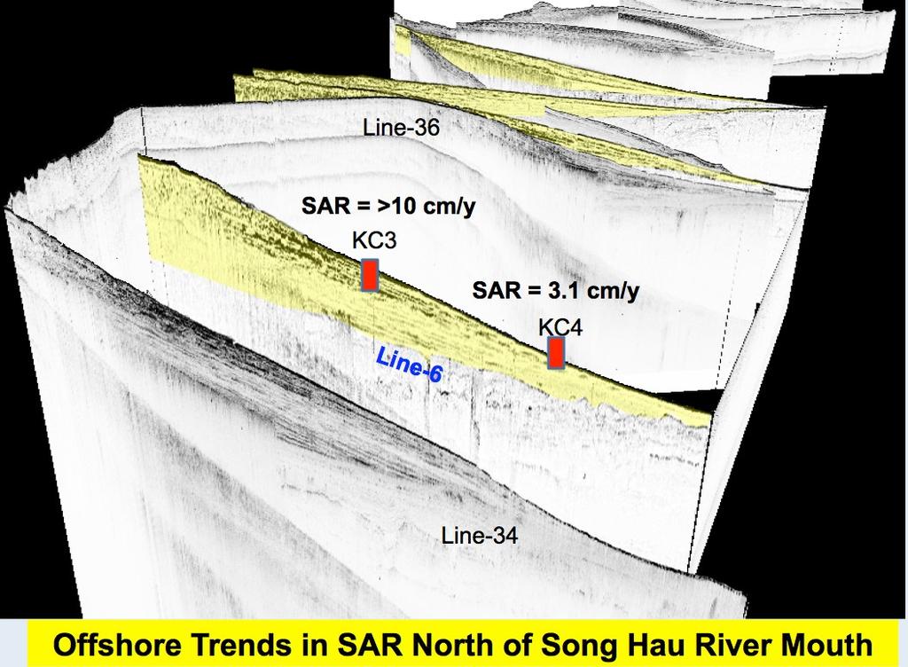
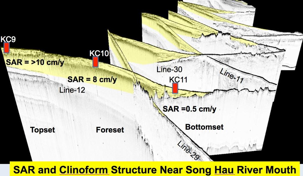
7 Figure 4. Selected seismic CHIRP sonar profiles on the shelf with 210 Pb derived accumuation rates. 7
8 The preliminary analysis of our seismic profiles show the Mekong River s deltaic sediment mainly deposited across the shelf within water depths less than 20 m. The deltaic sediments have formed a typical clinform structure with topset, foreset and bottomset beds. Table 1: The geochecmical analysis results ( 210 Pb and 14 C) form the Kasten cores. MEKONG SHELF SEDIMENTATION RATES 210 Pb SAR XS 210 Pb 14 C <50cm 14 C Core Agreement Core cm/y Penetrat. cm 210 Pb Linearity SAR (cm/y) 210 Pb + 14 C KC3 213 Poor Compatible KC Excellent Compatible KC9 280 Poor KC Fair (0.31) Compatible KC Very Good Compatible KC12 (47) Poor KC (103) Fair (0.10) Compatible KC15 2 (45) Very Good KC (63) Good Compatible KC (51) Fair KC23 (47) Poor Compatible KC Good KC Excellent KC Good KC Very Good Compatible (0.22) Compatible 8
9 IMPACT/APPLICATIONS By comparing high resolution seismic profiles, water depth profiles, the water column measurements, and the coring results from the two field cruises (one summer and one winter), seasonal contrasts in depositional and erosional regimes can be assessed. In addition, temporal variations in the nature of the channel morphology can be determined as well as any potential temporal variability in the distributions of deltaic muds within the distributary channels. The replication of the sonar profiles just seaward of the subaerial delta plain should document whether or not the leading edge of this tide- dominated deltaic system is prograding or eroding over time. These data, coupled with the geochronological measurements, will be used to assess the overall nature of sedimentation in this tide- dominated deltaic system, particularly examining their seasonal differences. TRANSITIONS The initial results of this research effort on the Mekong River delta shelf and river channels has been and will continue to be transferred to our Vietnamese colleagues and to our ONR collaborators on the project. The high-resolution CHIRP sonar profiles should provide a 3-D understanding of the distribution, thickness and sequence stratigraphy of the Mekong deltaic clinoform. The geochemical analyses, sediment deposition and accumulation rates, sediment distribution and budgets, and grain- size data will be key input parameters for numerical models examining sediment dynamics on the Mekong shelf. RELATED PROJECTS Related projects in the Tropical Deltas DRI are underway by C. Nittrouer, A. Ogston, M. Allison, D. Roelvink, and S. Jachec. PUBLICATIONS 1) Paul Liu and Chi Lu, Natural and Human Impacts on Recent Development of Asian Large Rivers and Deltas. AGU-fall, Abstract. 2) Paul Liu, 2015, Flux and fates of Asian major river derived sediments to the sea, Asian Marine Geology Conference, Abstract. [We could add the titles of our 2 Ocean Sciences abstracts, but they have not been officially accepted yet] 3) D. DeMaster, J.P. Liu, C. Nittrouer, E. Eidam, and N. Thanh, Establishing rates of sediment accumulation on the Mekong shelf: Radiochemical approaches based on 210 Pb and 14 C distributions. Abstract for 2016 Ocean Sciences Meeting, New Orleans (Feb. 2016). 9
DISTRIBUTION STATEMENT A. Approved for public release; distribution is unlimited.
 DISTRIBUTION STATEMENT A. Approved for public release; distribution is unlimited. Coupled Process Studies and Numerical Simulations of Channel Hydrodynamics and Sand Dynamics in Tide-Dominated River Channels:
Sediment Trapping Pathways and Mechanisms through the Mekong Tidal River, Mangrove Shoreline and Subaqueous Delta
 DISTRIBUTION STATEMENT A. Approved for public release; distribution is unlimited. Sediment Trapping Pathways and Mechanisms through the Mekong Tidal River, Mangrove Shoreline and Subaqueous Delta Andrea
Character and History of the Yangtze Mud Wedge, Fujian Province
 Character and History of the Yangtze Mud Wedge, Fujian Province John D. Milliman Virginia Institute of Marine Science, College of William and Mary, Gloucester Pt, VA 23062 phone: (804) 684-7112 fax: (804)
DISTRIBUTION STATEMENT A. Approved for public release; distribution is unlimited.
 DISTRIBUTION STATEMENT A. Approved for public release; distribution is unlimited. Coupled Process Studies and Numerical Simulations of Channel Hydrodynamics and Sand Dynamics in Tide-Dominated River Channels:
Shelf And Slope Sediment Transport In Strataform
 Shelf And Slope Sediment Transport In Strataform David A. Cacchione Woods Hole Group 1167 Oddstad Drive Redwood City, MA 94063 phone: 650-298-0520 fax: 650-298-0523 email: dcacchione@whgrp.com Award #:
Sediment Trapping Pathways and Mechanisms through the Mekong Tidal River and Subaqueous Delta
 DISTRIBUTION STATEMENT A. Approved for public release; distribution is unlimited. Sediment Trapping Pathways and Mechanisms through the Mekong Tidal River and Subaqueous Delta Andrea S. Ogston School of
Sediment Transport and Strata Formation in the Adriatic Sea
 Sediment Transport and Strata Formation in the Adriatic Sea Wayne R. Geyer James D. Irish Peter A. Traykovski Woods Hole Oceanographic Institution Woods Hole, MA 02543 Tel. (508) 289-2868, Fax: (508) 457-2194,
Sediment Dispersal from the Apennine Rivers
 Sediment Dispersal from the Apennine Rivers Gail C. Kineke Dept of Geology and Geophysics Boston College Chestnut Hill, MA 02467 phone: 617-552-3655 fax: 617-552-2462 email:kinekeg@bc.edu Award # N00014-02-1-0234
Processes Controlling Transfer of Fine-Grained Sediment in Tidal Systems Spanning a Range of Fluvial Influence
 DISTRIBUTION STATEMENT A. Approved for public release; distribution is unlimited. Processes Controlling Transfer of Fine-Grained Sediment in Tidal Systems Spanning a Range of Fluvial Influence Andrea S.
Sediment Transport at Density Fronts in Shallow Water: a Continuation of N
 DISTRIBUTION STATEMENT A. Approved for public release; distribution is unlimited. Sediment Transport at Density Fronts in Shallow Water: a Continuation of N00014-08-1-0846 David K. Ralston Applied Ocean
The Impact of River Basin Size on the Distribution and Character of Preserved Strata: A Comparison of the Po and Apennine Systems
 The Impact of River Basin Size on the Distribution and Character of Preserved Strata: A Comparison of the Po and Apennine Systems Robert A. Wheatcroft College of Oceanic & Atmospheric Sciences Oregon State
Accommodation- vs. supply-dominated systems for sediment partitioning to deep water. Supplementary documents
 GSA Data Repository 2019145 1 2 Accommodation- vs. supply-dominated systems for sediment partitioning to deep water Supplementary documents 3 4 5 6 Jinyu Zhang 1, Wonsuck Kim 1, Cornel Olariu 1,2, Ronald
Formation of Crenulated Clinoforms on Continental Shelves
 Formation of Crenulated Clinoforms on Continental Shelves P. Puig Institut de Ciències del Mar (CSIC) Passeig Marítim de la Barceloneta, 37-49 Barcelona 83, Spain phone: +34 93 23 9518 fax: +34 93 23 9555
Processes Controlling Transfer of Fine-Grained Sediment Within and Between Channels and Flats on Intertidal Flats
 Processes Controlling Transfer of Fine-Grained Sediment Within and Between Channels and Flats on Intertidal Flats Andrea S. Ogston School of Oceanography Box 357940 Seattle, WA 98195 phone: (206) 543-0768
Seabed Dynamics in the Adriatic Sea and Western Gulf of Lions
 Seabed Dynamics in the Adriatic Sea and Western Gulf of Lions Robert A. Wheatcroft College of Oceanic & Atmospheric Sciences Oregon State University Corvallis, OR 97331 phone: (541) 737-3891 fax: (541)
Geological/Geophysical Studies in East Asian Marginal Seas, FY2002
 Geological/Geophysical Studies in East Asian Marginal Seas, FY2002 John D. Milliman and Jesse McNinch School of Marine Science College of William and Mary Gloucester Pt, VA 23062 Phone: 804-684-7112, 7191
FIELD MEASUREMENTS OF SEDIMENT TRANSPORT PROCESSES IN STRATAFORM
 FIELD MEASUREMENTS OF SEDIMENT TRANSPORT PROCESSES IN STRATAFORM LONG-TERM GOALS David A. Cacchione U.S. Geological Survey 345 Middlefield Road, MS-999 Menlo Park, CA 94025 phone: 415-329-5481 fax: 415-329-5411
Emily F. Eidam curriculum vitae
 Emily F. Eidam curriculum vitae University of North Carolina Chapel Hill eeidam@email.unc.edu Department of Marine Sciences (919) 843-5045 3117C Murray Hall CB #3300 Chapel Hill, NC 27599-3300 Education
Award Number N
 Toward Linking Seabed Stratigraphy and Nested Seismic Datasets in STRATAFORM: Finalizing Plans for Long Coring and Synthesizing Existing Physical Property Data Dr. Clark R. Alexander Skidaway Institute
Processes Affecting Exchange of Mud Between Tidal Channels and Flats
 DISTRIBUTION STATEMENT A: Approved for public release; distribution is unlimited. Processes Affecting Exchange of Mud Between Tidal Channels and Flats Timothy G. Milligan and Brent A. Law Fisheries and
Geophysical and Geological Reconnaissance for the ONR Geoclutter Program
 Geophysical and Geological Reconnaissance for the ONR Geoclutter Program James A. Austin, Jr., John A. Goff University of Texas Institute for Geophysics 4412 Spicewood Springs Rd., Bldg. 600 Austin, TX
SEDIMENT TRANSPORT AND GO-CONG MORPHOLOGICAL CHANGE MODELING BY TELEMAC MODEL SUITE
 SEDIMENT TRANSPORT AND GO-CONG MORPHOLOGICAL CHANGE MODELING BY TELEMAC MODEL SUITE TABLE OF CONTENTS 1. INTRODUCTION... 2 2. OBJECTIVES... 2 3. METHOLOGY... 2 4. MODEL CALIBRATION, VALIDATION OF SEDIMENT
Margin Morphodynamics: Debris Flows, Turbidity Currents and Experimental Margin Stratigraphy
 Margin Morphodynamics: Debris Flows, Turbidity Currents and Experimental Margin Stratigraphy Gary Parker St. Anthony Falls Laboratory University of Minnesota Mississippi River at 3 rd Ave. SE Minneapolis,
Strataform Plume Study
 LONG-TERM GOAL Strataform Plume Study James F. Lynch James D. Irish Woods Hole Oceanographic Institution Woods Hole, MA 543 phone: (58) 89-3 fax: (58) 457-94 e-mail: jlynch@whoi.edu phone: (58) 89-73 fax:
UUV Operations to Characterize Circulation and Morphology of Tidal Flats
 UUV Operations to Characterize Circulation and Morphology of Tidal Flats Mark A. Moline Center for Coastal Marine Sciences and Biological Sciences Department California Polytechnic State University 1 Grand
Sediment Flux and Trapping on the Skagit Tidal Flats
 Sediment Flux and Trapping on the Skagit Tidal Flats W. Rockwell Geyer Woods Hole Oceanographic Institution MS 11, Woods Hole, MA 02543 phone: 508-289-2868 fax: 508-457-2194 email: rgeyer@whoi.edu Peter
The Seasonal Evolution of Sea Ice Floe Size Distribution
 DISTRIBUTION STATEMENT A. Approved for public release; distribution is unlimited. The Seasonal Evolution of Sea Ice Floe Size Distribution Jacqueline A. Richter-Menge and Donald K. Perovich CRREL, 72 Lyme
FINAL REPORT. AASERT Award: Augmentation of studies into the Formation of Sedimentary Strata on Continental Margins
 FINAL REPORT AASERT Award: Augmentation of studies into the Formation of Sedimentary Strata on Continental Margins Roger D. Flood Marine Sciences Research Center State University of New York Stony Brook,
Sediment delivery from the Fly River tidally dominated delta to the nearshore marine environment and the impact of El Niño
 Click Here for Full Article JOURNAL OF GEOPHYSICAL RESEARCH, VOL. 113,, doi:10.1029/2006jf000669, 2008 Sediment delivery from the Fly River tidally dominated delta to the nearshore marine environment and
Field and Numerical Study of the Columbia River Mouth
 DISTRIBUTION STATEMENT A. Approved for public release; distribution is unlimited. Field and Numerical Study of the Columbia River Mouth Guy Gelfenbaum 400 Natural Bridges Dr. Santa Cruz, CA 95060 Phone:
An Investigation of the Influence of Waves on Sediment Processes in Skagit Bay
 DISTRIBUTION STATEMENT A. Approved for public release; distribution is unlimited. An Investigation of the Influence of Waves on Sediment Processes in Skagit Bay Geoffrey W. Cowles School for Marine Science
The Effects of Flooding on Shirakawa Delta Morphology
 09 0 th International Conference of the International Institute for Infrastructure Resilience and Reconstruction (I3R) 0 May 04 Purdue University, West Lafayette, Indiana, USA The Effects of Flooding on
Processes Affecting Exchange of Mud Between Tidal Channels and Flats
 DISTRIBUTION STATEMENT A. Approved for public release; distribution is unlimited. Processes Affecting Exchange of Mud Between Tidal Channels and Flats Brent Law and Timothy G. Milligan Fisheries and Oceans
Bulletin of Earth Sciences of Thailand
 Depositional Environments and Stratigraphic Development of the Grand Taman Sari Circuit Outcrop: an Analogue for Transgressive Mahakam Delta Successions Ridha Santika Riadi Petroleum Geoscience Program,
Processes Affecting Exchange of Mud between Tidal Channels and Flats
 DISTRIBUTION STATEMENT A. Approved for public release; distribution is unlimited. Processes Affecting Exchange of Mud between Tidal Channels and Flats Paul S. Hill Department of Oceanography Dalhousie
The Physical Context for Thin Layers in the Coastal Ocean
 The Physical Context for Thin Layers in the Coastal Ocean David M. Fratantoni Physical Oceanography Department Woods Hole Oceanographic Institution Woods Hole, MA 02543 phone: (508) 289-2908 fax: (508)
Wave Propagation Across Muddy Seafloors
 Wave Propagation Across Muddy Seafloors Steve Elgar Woods Hole Oceanographic Institution Woods Hole, MA 02543 phone: (508) 289-3614 fax: (508) 457-2194 email: elgar@whoi.edu Grant numbers: N00014-07-10461,
Session: For more information:
 Session: For more information: www.hydropower.org/congress Sediment management: mitigation options? Marc Goichot World Hydropower Congress Beijing, China 21 May 2015 A project jointly implemented by MRCS
Land-fjord interaction and the impact of changing sedimentation rates on fjord environments
 Land-fjord interaction and the impact of changing sedimentation rates on fjord environments An integrated study of Arctic sediment transport from land to sea Maria Jensen (University Centre in Svalbard,
Stratigraphic and Geoacoustic Characterization of the Outer New Jersey Shelf
 DISTRIBUTION STATEMENT A: Approved for public release; distribution is unlimited. Stratigraphic and Geoacoustic Characterization of the Outer New Jersey Shelf John A. Goff Institute for Geophysics, Jackson
Forecast of Nearshore Wave Parameters Using MIKE-21 Spectral Wave Model
 Forecast of Nearshore Wave Parameters Using MIKE-21 Spectral Wave Model Felix Jose 1 and Gregory W. Stone 2 1 Coastal Studies Institute, Louisiana State University, Baton Rouge, LA 70803 2 Coastal Studies
Predicting the Evolution of Tidal Channels in Muddy Coastlines
 Predicting the Evolution of Tidal Channels in Muddy Coastlines Sergio Fagherazzi Department of Earth Sciences and Center for Computational Science Boston University, Boston MA 02215 Phone: (617) 353-2092
Maureen Davies Applied Physics Laboratory 1013 NE 40th Street Seattle, WA March 2004
 The role of modern sedimentation and particulate transport in the formation of the central submarine rises in the bathymetry of Puget Sound, Washington Maureen Davies Applied Physics Laboratory 1013 NE
Department Travels
 23 Department Travels... 2015-2016 The Rice Earth Science department is frequently on the move, exploring both familiar and foreign locations, seeking to uncover natural mysteries hidden all across the
ONR Tidal Flats DRI: Planning Joint Modeling and Field Exercises
 ONR Tidal Flats DRI: Planning Joint Modeling and Field Exercises Lyle Hibler Battelle/Marine Research Operations 1529 West Sequim Bay Road Sequim, WA 98382 Phone: (360) 681-3616 Fax: (360) 681-3681 Email:
Morphology of Canal Isabela in the Galapagos Islands
 Morphology of Canal Isabela in the Galapagos Islands Allison Cougan University of Washington School of Oceanography Box 357940 Seattle, WA 98195 allcoug@u.washington.edu 206.427.9084 November 23, 2005
Field and Numerical Study of the Columbia River Mouth
 DISTRIBUTION STATEMENT A. Approved for public release; distribution is unlimited. Field and Numerical Study of the Columbia River Mouth Guy Gelfenbaum 400 Natural Bridges Dr. Santa Cruz, CA 95060 Phone:
Hydrodynamics in Shallow Estuaries with Complex Bathymetry and Large Tidal Ranges
 DISTRIBUTION STATEMENT A: Approved for public release; distribution is unlimited. Hydrodynamics in Shallow Estuaries with Complex Bathymetry and Large Tidal Ranges Stephen G. Monismith Dept of Civil and
Africa Partnership Station: Coastal Processes
 DISTRIBUTION STATEMENT A. Approved for public release; distribution is unlimited. Africa Partnership Station: Coastal Processes Cheryl Hapke U.S. Geological Survey 600 Fourth St. South St. Petersburg,
Analysis of Mixing and Dynamics Associated with the Dissolution of Hurricane-Induced Cold Wakes
 DISTRIBUTION STATEMENT A: Approved for public release; distribution is unlimited. Analysis of Mixing and Dynamics Associated with the Dissolution of Hurricane-Induced Cold Wakes Carol Anne Clayson Dept.
Coastal Ocean Circulation Experiment off Senegal (COCES)
") DISTRIBUTION STATEMENT A: Approved for public release; distribution is unlimited. Coastal Ocean Circulation Experiment off Senegal (COCES) Pierre-Marie Poulain Istituto Nazionale di Oceanografia e di Geofisica
DISTRIBUTION STATEMENT A: Approved for public release; distribution is unlimited. Coastal Ocean Circulation Experiment off Senegal (COCES) Pierre-Marie Poulain Istituto Nazionale di Oceanografia e di Geofisica
East Asia & Southeast Asia region
 Deltas at Risk Dynamics and vulnerability of river delta system East Asia & Southeast Asia region Yoshiki Saito Geological Survey of Japan Huanghe (Yellow River) Plateau Tibetan Himalayas Old Huanghe (500
The Seasonal Evolution of Sea Ice Floe Size Distribution
 DISTRIBUTION STATEMENT A. Approved for public release; distribution is unlimited. The Seasonal Evolution of Sea Ice Floe Size Distribution Jacqueline A. Richter-Menge and Donald K. Perovich CRREL 72 Lyme
Main issues of Deltas
 Global sediment supply to coastal seas and oceans; location of major river deltas RIVER DELTAS Depositional processes - Course Coastal Morphodynamics GEO3-436; lecture 4 Nile Delta, Egypt Solo Delta, Java,
Synthetic Aperture Radar Imagery of the Ocean Surface During the Coastal Mixing and Optics Experiment
 Synthetic Aperture Radar Imagery of the Ocean Surface During the Coastal Mixing and Optics Experiment LONG TERM GOAL Donald R. Thompson and David L. Porter Ocean Remote Sensing Group Johns Hopkins University/APL
Application of Predictive Modeling to the Lower Cretaceous Sedimentary Sequences of the Central Scotian Basin
 Application of Predictive Modeling to the Lower Cretaceous Sedimentary Sequences of the Central Scotian Basin Christopher R. Sangster 1, Nicolas Hawie 2, Georgia Pe-Piper 1, Francky Saint-Ange 2, David
2) re-positioning of the SSS data, 3) individuation of geomorphological features and morphometrical parameters correlated to instability phenomena.
 re-positioning of the SSS data, 3) individuation of geomorphological features and morphometrical parameters correlated to instability phenomena.") HIGH-RESOLUTION SIDE SCAN SONAR AND MULTIBEAM DATA PROCESSING AND MERGING TO STUDY SUBMARINE INSTABILITY PHENOMENA ON VOLCANIC ISLANDS (PONTINE, CAMPANIAN AND AEOLIAN ARCHIPELAGOS) A. BOSMAN Extended abstract:
HIGH-RESOLUTION SIDE SCAN SONAR AND MULTIBEAM DATA PROCESSING AND MERGING TO STUDY SUBMARINE INSTABILITY PHENOMENA ON VOLCANIC ISLANDS (PONTINE, CAMPANIAN AND AEOLIAN ARCHIPELAGOS) A. BOSMAN Extended abstract:
Mapping annual sediment change in the Monterey Canyon head using serial multibeam bathymetry surveys
 Mapping annual sediment change in the Monterey Canyon head using serial multibeam bathymetry surveys Abstract Submarine canyons were once thought to be the result of river processes during periods of glaciation
An overview of USGS Hurricane Sandy Supplemental Studies along the Delmarva Peninsula
 An overview of USGS Hurricane Sandy Supplemental Studies along the Delmarva Peninsula Neil K. Ganju, Laura L. Brothers, Nathaniel G. Plant, Christopher G. Smith, E. Robert Thieler Coastal and Marine Geology
Predicting the Evolution of Tidal Channels in Muddy Coastlines
 Predicting the Evolution of Tidal Channels in Muddy Coastlines Sergio Fagherazzi Address Department of Earth Sciences and Center for Computational Science, Boston University, Boston MA 02215 Phone: 617-353-2092
Coastal Mixing and Optics
 Coastal Mixing and Optics W. Scott Pegau College of Oceanic and Atmospheric Sciences Ocean. Admin. Bldg. 104 Oregon State University Corvallis, OR 97331-5503 Phone: (541) 737-5229 fax: (541) 737-2064 email:
Stratigraphic and Geoacoustic Characterization of the Outer New Jersey Shelf
 Stratigraphic and Geoacoustic Characterization of the Outer New Jersey Shelf John A. Goff Institute for Geophysics, Jackson School of Geoscience University of Texas at Austin JJ Pickle Research Campus,
Chirp Sonar Investigation of the Eel River Subaqueous Delta and Surrounding Shallow-Water Regions, Offshore California
 Chirp Sonar Investigation of the Eel River Subaqueous Delta and Surrounding Shallow-Water Regions, Offshore California Neal Driscoll Geology & Geophysics Department Woods Hole Oceanographic Institution
Development and application of demonstration MIKE 21C morphological model for a bend in Mekong River
 Development and application of demonstration MIKE 21C morphological model for a bend in Mekong River September 2015 0 Table of Contents 1. Introduction... 2 2. Data collection... 3 2.1 Additional data...
Tidal and seasonal dynamics of a muddy inner shelf environment, Gulf of Papua
 Click Here for Full Article JOURNAL OF GEOPHYSICAL RESEARCH, VOL. 113,, doi:10.1029/2006jf000681, 2008 Tidal and seasonal dynamics of a muddy inner shelf environment, Gulf of Papua D. P. Martin, 1 C. A.
Floc Fraction in the Gulf of Lions
 Floc Fraction in the Gulf of Lions Paul S. Hill Department of Oceanography Dalhousie University Halifax, Nova Scotia, CANADA B3H 4J1 Phone: (902) 494-2266 fax: (902) 494-3877 email: paul.hill@dal.ca Timothy
Fine-scale Survey of Right and Humpback Whale Prey Abundance and Distribution
 DISTRIBUTION STATEMENT A: Approved for public release; distribution is unlimited. Fine-scale Survey of Right and Humpback Whale Prey Abundance and Distribution Joseph D. Warren School of Marine and Atmospheric
Wave-Sediment Interaction in Muddy Environments: A Field Experiment
 Wave-Sediment Interaction in Muddy Environments: A Field Experiment Alexandru Sheremet Civil & Coastal Engineering, 365 Weil Hall, University of Florida, Gainesville, FL 32611 phone: (352) 392-9537/1429
Predicting the Distribution and Properties of Buried Submarine Topography on Continental Shelves
 Predicting the Distribution and Properties of Buried Submarine Topography on Continental Shelves Patricia Wiberg Department of Environmental Sciences, University of Virginia P.O. Box 400123, Charlottesville,
Impact of Changes in Morphology on Extent and Duration of Inundation during Tropical Cyclones
 DISTRIBUTION STATEMENT A. Approved for public release; distribution is unlimited. Impact of Changes in Morphology on Extent and Duration of Inundation during Tropical Cyclones Jayaram Veeramony Code 7322,
Analysis of Mixing and Dynamics Associated with the Dissolution of Hurricane-Induced Cold Wakes
 DISTRIBUTION STATEMENT A: Approved for public release; distribution is unlimited. Analysis of Mixing and Dynamics Associated with the Dissolution of Hurricane-Induced Cold Wakes Carol Anne Clayson Dept.
Lagrangian Tracer Transport and Dispersion in Shallow Tidal Inlets & River Mouths
 DISTRIBUTION STATEMENT A: Distribution approved for public release; distribution is unlimited. Lagrangian Tracer Transport and Dispersion in Shallow Tidal Inlets & River Mouths Profs. R..T. Guza and Falk
Effects of Tides on Deltaic Deposition: Causes and Responses*
 Effects of Tides on Deltaic Deposition: Causes and Responses* Piret Plink-Bjorklund 1 Search and Discovery Article #50626 (2012)** Posted June 25, 2012 *Adapted from oral presentation at AAPG Annual Convention
Variations of Kuroshio Intrusion and Internal Waves at Southern East China Sea
 Variations of Kuroshio Intrusion and Internal Waves at Southern East China Sea Ren-Chieh Lien Applied Physics Laboratory University of Washington Seattle, Washington 98105 phone: (206) 685-1079 fax: (206)
ES120 Sedimentology/Stratigraphy
 Midterm Exam 5/05/08 NAME: 1. List or describe 3 physical processes that contribute to the weathering of rocks (3pts). exfoliation frost wedging many others. roots, thermal expansion/contraction also credit
Sequence Stratigraphy. Historical Perspective
 Sequence Stratigraphy Historical Perspective Sequence Stratigraphy Sequence Stratigraphy is the subdivision of sedimentary basin fills into genetic packages bounded by unconformities and their correlative
Linking surficial geomorphology with vertical structure in high and low energy marine
 Linking surficial geomorphology with vertical structure in high and low energy marine environments Erica Sampaga 1 Advisors: Miles Logsdon, Emily Roland 1 University of Washington, School of Oceanography
The Role of Seabed Dynamics In Controlling the Distribution and Preservation of Polycyclic Aromatic Hydrocarbons (PAHs) in Estuarine Sediments
 in Estuarine Sediments") The Role of Seabed Dynamics In Controlling the Distribution and Preservation of Polycyclic Aromatic Hydrocarbons (PAHs) in Estuarine Sediments Elizabeth A. Canuel School of Marine Science/Virginia Institute
The Role of Seabed Dynamics In Controlling the Distribution and Preservation of Polycyclic Aromatic Hydrocarbons (PAHs) in Estuarine Sediments Elizabeth A. Canuel School of Marine Science/Virginia Institute
Zou Zou Kuzyk Assistant Professor Centre for Earth Observation Science (CEOS) & Geological Sciences, Clayton H. Riddell Faculty of Environment, Earth
 & Geological Sciences, Clayton H. Riddell Faculty of Environment, Earth") Zou Zou Kuzyk Assistant Professor Centre for Earth Observation Science (CEOS) & Geological Sciences, Clayton H. Riddell Faculty of Environment, Earth and Resources University of Manitoba (with input from
Zou Zou Kuzyk Assistant Professor Centre for Earth Observation Science (CEOS) & Geological Sciences, Clayton H. Riddell Faculty of Environment, Earth and Resources University of Manitoba (with input from
Internal Tide Generation in the Indonesian Seas
 Internal Tide Generation in the Indonesian Seas Amy Ffield Earth and Space Research, 290 Clausland Mountain Road, Upper Grandview, NY 10960 Phone: (845) 353-1733 Fax: (845) 353-1733 Email: ffield@esr.org
Internal Waves in the Vicinity of the Kuroshio Path
 Internal Waves in the Vicinity of the Kuroshio Path Ren-Chieh Lien Applied Physics Laboratory University of Washington Seattle, Washington 98105 phone: (206) 685-1079 fax: (206) 543-6785 email: lien@apl.washington.edu
SEA BOTTOM MORPHOLOGY AND SEDIMENT DISTRIBUTION OF KUALA BESAR KELANTAN RIVER DELTA AND ITS OFFSHORE AREAS
 BORNEO SCIENCE 35: SEPTEMBER 2014 SEA BOTTOM MORPHOLOGY AND SEDIMENT DISTRIBUTION OF KUALA BESAR KELANTAN RIVER DELTA AND ITS OFFSHORE AREAS Nurul Afifah Mohd Radzir* 1, Che Aziz Ali 1, Kamal Roslan Mohamed
Floc Fraction in the Gulf of Lions
 Floc Fraction in the Gulf of Lions Paul S. Hill Department of Oceanography Dalhousie University Halifax, Nova Scotia, CANADA B3H 4J1 Phone: (902) 494-2266 fax: (902) 494-3877 email: paul.hill@dal.ca Timothy
Comparing suspended sediment concentrations derived from a model and collected in a tidally dominated area
 Comparing suspended sediment concentrations derived from a model and collected in a tidally dominated area Maryam Rahbani, Department of oceanic and atmospheric science University of Hormozgan, maryamrahbani@yahoo.com
Search and Discovery Article #40536 (2010) Posted June 21, 2010
 Posted June 21, 2010") Modern Examples of Mass Transport Complexes, Debrite and Turbidite Associations: Geometry, Stratigraphic Relationships and Implications for Hydrocarbon Trap Development* Fabiano Gamberi 1, Marzia Rovere
Modern Examples of Mass Transport Complexes, Debrite and Turbidite Associations: Geometry, Stratigraphic Relationships and Implications for Hydrocarbon Trap Development* Fabiano Gamberi 1, Marzia Rovere
Dynamics of Ripples on the Sandy Inner Shelf off Martha s Vineyard: Surveys, Field Measurements, and Models
 Dynamics of Ripples on the Sandy Inner Shelf off Martha s Vineyard: Surveys, Field Measurements, and Models Christopher R. Sherwood U.S. Geological Survey, Woods Hole Science Center 384 Woods Hole Road
Near-Surface Dispersion and Circulation in the Marmara Sea (MARMARA)
") DISTRIBUTION STATEMENT A. Approved for public release; distribution is unlimited. Near-Surface Dispersion and Circulation in the Marmara Sea (MARMARA) Pierre-Marie Poulain Istituto Nazionale di Oceanografia
DISTRIBUTION STATEMENT A. Approved for public release; distribution is unlimited. Near-Surface Dispersion and Circulation in the Marmara Sea (MARMARA) Pierre-Marie Poulain Istituto Nazionale di Oceanografia
Figure 1. Sediment balance of the 1500 km-long muddy coast of South America
 a b c Figure 1. Sediment balance of the 1500 km-long muddy coast of South America between the Amazon and the Orinoco rivers. a, map of the Amazon-Orinoco sediment system. The black box delimits the area
Regional-scale understanding of the geologic character and sand resources of the Atlantic inner continental shelf, Maine to Virginia
 Regional-scale understanding of the geologic character and sand resources of the Atlantic inner continental shelf, Maine to Virginia Workshop on Dredging, Beach Nourishment and Bird Conservation Atlantic
Changes in Geomorphology and Backscatter Patterns in Mount Misery Shoal, Long Island Sound as Revealed through Multiple Multibeam Surveys
 Changes in Geomorphology and Backscatter Patterns in Mount Misery Shoal, Long Island Sound as Revealed through Multiple Multibeam Surveys Laurie A. Zaleski Laurie.Zaleski@msrc.sunysb.edu, Roger D. Flood
Geomorphology Studies
 Geomorphology Studies Technical Workgroup Meeting February 14, 2012 Prepared by: Tetra Tech Prepared for: Alaska Energy Authority Overall Goal Geomorphology Studies Two studies Geomorphology Study (RSP
Evaluating the Discrete Element Method as a Tool for Predicting the Seasonal Evolution of the MIZ
 DISTRIBUTION STATEMENT A. Approved for public release; distribution is unlimited. Evaluating the Discrete Element Method as a Tool for Predicting the Seasonal Evolution of the MIZ Arnold J. Song Cold Regions
ANALYSIS OF THE CAUSES AND CONSEQUENCES OF SUBMARINE SLOPE FAILURE
 ANALYSIS OF THE CAUSES AND CONSEQUENCES OF SUBMARINE SLOPE FAILURE Lincoln F. Pratson Institute of Arctic and Alpine Research University of Colorado, Boulder, CO, 80309-0450 phone: (303) 492-6752, fax:
Appendix G.19 Hatch Report Pacific NorthWest LNG Lelu Island LNG Maintenance Dredging at the Materials Offloading Facility
 Appendix G.19 Hatch Report Pacific NorthWest LNG Lelu Island LNG Maintenance Dredging at the Materials Offloading Facility Project Memo H345670 To: Capt. David Kyle From: O. Sayao/L. Absalonsen December
STREAM SYSTEMS and FLOODS
 STREAM SYSTEMS and FLOODS The Hydrologic Cycle Precipitation Evaporation Infiltration Runoff Transpiration Earth s Water and the Hydrologic Cycle The Hydrologic Cycle The Hydrologic Cycle Oceans not filling
Precipitation Evaporation Infiltration Earth s Water and the Hydrologic Cycle. Runoff Transpiration
 STREAM SYSTEMS and FLOODS The Hydrologic Cycle Precipitation Evaporation Infiltration Earth s Water and the Hydrologic Cycle Runoff Transpiration The Hydrologic Cycle The Hydrologic Cycle Oceans not filling
High Resolution Surface Characterization from Marine Radar Measurements
 DISTRIBUTION STATEMENT A: Distribution approved for public release; distribution is unlimited High Resolution Surface Characterization from Marine Radar Measurements Hans C. Graber CSTARS - University
Michael Walsworth, Ryan Sullivan, Simi Odueyungbo, William Budd
 Michael Walsworth, Ryan Sullivan, Simi Odueyungbo, William Budd Estuarine Environment At first (Pritchard, 1967), an estuary was defined by the salinity of the water. Then by Clifton (1982) as an inlet
Continuous Monitoring of Fish Population and Behavior by Instantaneous Continental-Shelf-Scale Imaging with Ocean-Waveguide Acoustics
 Continuous Monitoring of Fish Population and Behavior by Instantaneous Continental-Shelf-Scale Imaging with Ocean-Waveguide Acoustics PI: Prof. Nicholas C. Makris Massachusetts Institute of Technology
Dynamics of Ripples on the Sandy Inner Shelf off Martha s Vineyard: Surveys, Field Measurements, and Models
 Dynamics of Ripples on the Sandy Inner Shelf off Martha s Vineyard: Surveys, Field Measurements, and Models Christopher R. Sherwood U.S. Geological Survey, Woods Hole Science Center 384 Woods Hole Road