46ºN to 75ºN (Quebec City to the Beaufort Sea): 2011 Ocean Mapping Group Operations in the Canadian Arctic, Part III. By Doug Cartwright
|
|
|
- Leon Gibbs
- 6 years ago
- Views:
Transcription
1 46ºN to 75ºN (Quebec City to the Beaufort Sea): 2011 Ocean Mapping Group Operations in the Canadian Arctic, Part III By Doug Cartwright Doug Cartwright, Christine Legere and Pim Kuus met up with the CCGS Amundsen in Sachs Harbour, NWT, on September 7, Their trip to the North was one of the most spectacular parts of the expedition and included stops in Yellowknife and Kugluktuk. From the sky you see the landscape quickly change from tundra to Arctic desert. Twin Otters brought the crew into Sachs Harbour and a Coast Guard helicopter was used to ferry passengers to the ship. The weather was perfectly clear during the flights, so there were beautiful views, especially of the Coppermine River as they approached Kugluktuk. Leg 2c continued in the Beaufort Sea where Leg 2b left off. The main focus was seabed mapping along the Beaufort Shelf with the CCGS Amundsen. Besides the Amundsen, they also had the opportunity to use a barge for mapping operations. The Amundsen is equipped with a ~30-ft barge. which is normally used by the Coast Guard to transport passengers or goods to and from shore in shallow waters. Earlier in the summer the Ocean Mapping Group had outfitted the barge with an EM3002 multibeam sonar and auxiliary instruments. The barge not only provided the opportunity to run some site-specific surveys while the Amundsen operations took place, but thanks to the EM3002, higher resolution data could be acquired. The Beaufort continental shelf is dotted with dome-shaped mounds. These features have been coined pingo-like-features (PL's) because of their morphological resemblance with pingos found on shore. Pingos are ice-cored hills and are quite common in the western Arctic landscape. Despite their common dome shape, geologists are uncertain if PLFs are really pingos; what they really are is unclear. Some PLFs appear to be venting gas or extruding fluids or mud. This activity is particularity interesting for geologists as it can be a source of hydrocarbons. In order to understand the processes involved, the barge was used to find the PLFs and map them in three dimensions. During five barge deployments, 24 PLFs were mapped, of which 16 had never been mapped before. A ridge-like feature was also discovered along the shelf which geologists believe to be remnants of an ancient shore line. One of the PLFs turned out to be a mud volcano. By comparing data with a previous survey a year earlier, it could be determined that the mud volcano had grown; i.e., the lobe of mud extruding from the crest had moved m and had grown thicker. (See images of the PLFs at the end of this article.) On September 22, Pim and James departed the Amundsen and Doug and Christine carried on with science activities for the remaining two weeks of the leg. During this next period, the priority was taken away from mapping and put towards other science activities, including identification and retrieval of seabed mooring installations and marine mammal surveys.
2 This leg of the journey also included the Schools on Board program ( that provides Canadian high school students with the opportunity to experience science sampling and research activities first hand onboard the icebreaker. Doug provided a presentation on acoustics and seabed mapping to the group that was well received. Numerous seabed mooring installations were retrieved on this leg of the trip. Seabed moorings are strings of instruments, which are fastened to the seabed for years at a time. During this period they collect data about the properties of the water column. The data can include suspended sediments, temperature and salinity profiles, water currents, and ice thickness. The moorings are not always where you expect them to be after a couple of years, therefore before retrieving the moorings, the Amundsen steams over them in multiple directions to try to identify them in the multibeam water-column imagery. The flotation buoys on the moorings act as excellent point scattering targets and the moorings show up clearly in the water-column imaging. This shows the mooring recovery crew how much of the mooring is still there and what they can expect when they release the unit. On October 4, Doug and Christine left the Amundsen in Kugluktuk and welcomed Steve and Danar aboard.

3 3D sun-shaded image of the mud volcano. The slump and lobe seen in the foreground have buried an ice-keel scour.

4 Multibeam bathymetry of same mud volcano as above.

5 Barge EM3002 multibeam bathymetry of Kugmalit Pingos.
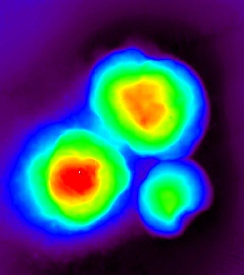
6 Three Sisters pingo-like-features.
Canadian activities in the Pacific Arctic Region: 2016 icebreaker plans.
 Canadian activities in the Pacific Arctic Region: 2016 icebreaker plans. Pacific Arctic Group meeting Arctic Science Summit Week, Fairbanks, Alaska 13 March 2016 CCGS Louis S. St-Laurent UNCLOS misson:
ArcticNet Western & Central Canadian Arctic
 ArcticNet Western & Central Canadian Arctic In this bulletin: ArcticNet Page 1 The ArcticNet IRIS framework Page 2 CCGS Amundsen and ArcticNet field work Page 3 Regional Impact Assessment Page 4 ArcticNet
CSL HERON MAPPING OPERATIONS, MAY 23 RD -JUNE 4 TH BLUE HILL BAY, MAINE, USA OCEAN MAPPING GROUP CRUISE REPORT JAMES MUGGAH AND TRAVIS HAMILTON
 CSL HERON MAPPING OPERATIONS, MAY 23 RD -JUNE 4 TH BLUE HILL BAY, MAINE, USA OCEAN MAPPING GROUP CRUISE REPORT JAMES MUGGAH AND TRAVIS HAMILTON SPRING 2009 / NOVEMBER 2009 OCEAN MAPPING GROUP UNIVERSITY
Challenges of Collecting Data for Article 76 in Ice Covered Waters of the Arctic
 Challenges of Collecting Data for Article 76 in Ice Covered Waters of the Arctic 5 th ABLOS Conference Monaco October 16, 2008 Richard MacDougall - Canada Jacob Verhoef - Canada Wendell Sanford - Canada
Applications of ice profiling sonar technology to scientific, engineering and operational issues in Polar and sub-polar waters
 Applications of ice profiling sonar technology to scientific, engineering and operational issues in Polar and sub-polar waters J.R. Marko, ASL Environmental Sciences Inc., Sidney, B.C., Canada And H. Melling,
Seafloor Mapping in the High Arctic: The Challenges and the Joys
 Seafloor Mapping in the High Arctic: The Challenges and the Joys Larry Mayer Center for Coastal and Ocean Mapping / NOAA- UNH Joint Hydrographic Center University of New Hampshire, USA Martin Jakobsson
Mapping and monitoring sedimentary processes and fluxes across fjord deltas - Baffin Island
 Mapping and monitoring sedimentary processes and fluxes across fjord deltas - Baffin Island John E. Hughes Clarke, Steve Brucker, Auke van der Werfe, Ian Church and Kashka Iwanowska Ocean Mapping Group,
Paleoceanography,, Seabed Morphology, and Geologic Framework of the Northwest Passage ArcticNet Project 1.6
 Paleoceanography,, Seabed Morphology, and Geologic Framework of the Northwest Passage ArcticNet Project 1.6 Robbie Bennett, Steve Blasco, Brian MacLean, Andre Rochon, John Hughes-Clarke, Jonathan Beaudoin,
SEISMIC CAMPAIGN SIMON STEVIN (Cruise No ) 10-4 OCTOBER 2016
 10-4 OCTOBER 2016") IWT SBO PROJECT 120003 SEARCH Archaeological heritage in the North Sea Development of an efficient assessment methodology and approach towards a sustainable management policy and legal framework in Belgium.
IWT SBO PROJECT 120003 SEARCH Archaeological heritage in the North Sea Development of an efficient assessment methodology and approach towards a sustainable management policy and legal framework in Belgium.
Sediment Transport and Strata Formation in the Adriatic Sea
 Sediment Transport and Strata Formation in the Adriatic Sea Wayne R. Geyer James D. Irish Peter A. Traykovski Woods Hole Oceanographic Institution Woods Hole, MA 02543 Tel. (508) 289-2868, Fax: (508) 457-2194,
Monitoring The Sand Extraction On The Belgian Continental Shelf
 Monitoring The Sand Extraction On The Belgian Continental Shelf Methodology, Results And Expectations K. Degrendele and M. Roche Within the framework of a sustainable exploitation of the mineral resources
Name PRIMARY SCHOOL DISCOVERY PACK. Use this pack to help you explore on your journey through space and time!
 Name PRIMARY SCHOOL DISCOVERY PACK Use this pack to help you explore on your journey through space and time! Scotland s Time Lords Welcome to the very start of your journey! This gallery is all about how
Meteor Cruise M54/ / Short Cruise Report
 Meteor Cruise M54/1 6.7. 11.7 / 14.7. 10.8. Short Cruise Report The R/V Meteor Cruise M54/1 is the first in a row of 3 expeditions, which lead the vessel for the first time to the Pacific Ocean for research
Bathymetry Measures the vertical distance from the ocean surface to mountains, valleys, plains, and other sea floor features
 1 2 3 4 5 6 7 8 9 10 11 CHAPTER 3 Marine Provinces Chapter Overview The study of bathymetry determines ocean depths and ocean floor topography. Echo sounding and satellites are efficient bathymetric tools.
ICE PRESSURE RIDGE IMPACTS ON OIL SPILLS IN THE ALASKAN OCS
 Ice in the Environment: Proceedings of the 16th IAHR International Symposium on Ice Dunedin, New Zealand, 2nd 6th December 2002 International Association of Hydraulic Engineering and Research ICE PRESSURE
NOAA S Arctic Program in 2017
 NOAA S Arctic Program in 2017 NOAA s Arctic Mission To determine how the Arctic system is changing on time scales of weeks to decades, particularly with respect to the consequences that the loss of sea
The Arctic Climate System GEOG 4271/5271. Mark C. Serreze Department of Geography University of Colorado, Boulder CO
 The Arctic Climate System GEOG 4271/5271 Mark C. Serreze Department of Geography University of Colorado, Boulder CO serreze@nsidc.org Why study the Arctic climate system? The fascinating processes that
Magnetotelluric and Seismic Investigation of Arc Melt Generation, Delivery, and Storage beneath Okmok Volcano
 Magnetotelluric and Seismic Investigation of Arc Melt Generation, Delivery, and Storage beneath Okmok Volcano PIs Ninfa Bennington (U. Wisconsin-Madison) and Kerry Key (Scripps Institution of Oceanography)
Chapter Overview. Bathymetry. Measuring Bathymetry. Measuring Bathymetry
 CHAPTER 3 Marine Provinces Chapter Overview The study of bathymetry determines ocean depths and ocean floor topography. Echo sounding and satellites are efficient bathymetric tools. Most ocean floor features
Multibeam Mapping of Feature Rich Seafloor in the U.S. Pacific Remote Islands Marine National Monument and on Mendocino Ridge off the California Coast
 University of New Hampshire University of New Hampshire Scholars' Repository Center for Coastal and Ocean Mapping Center for Coastal and Ocean Mapping 3-2015 Multibeam Mapping of Feature Rich Seafloor
MARINE GEOLOGY & GEOGRAPHY
 MARINE GEOLOGY & GEOGRAPHY Bathymetry BATHYMETRY BATHYMETRY THE UNDERWATER EQUIVALENT TO TOPOGRAPHY THE STUDY OF WATER DEPTH A BATHYMETRIC MAP SHOWS FLOOR RELIEF OR TERRAIN AS CONTOUR LINES Bathymetry
Map shows 3 main features of ocean floor
 Map shows 3 main features of ocean floor 2017 Pearson Education, Inc. Chapter 3 Marine Provinces 2017 Pearson Education, Inc. 1 Chapter 3 Overview The study of bathymetry determines ocean depths and ocean
The Southeastern and Northeastern Beaufort Sea Marine Observatories
 The Southeastern and Northeastern Beaufort Sea Marine Observatories ArcticNet and IMG-Golder Alexandre Forest, Ph.D. Oceanographer, Golder Associates Ltd. BREA Meeting 2015, Inuvik, NWT 24-26 February
Office of Naval Research Arctic Observing Activities
 Office of Naval Research Arctic Observing Activities Jim Thomson Applied Physics Laboratory, University of Washington jthomson@apl.washington.edu Scott L. Harper, Program Officer, Arctic and Global Prediction
LANDFORM REGIONS IN CANADA. Classroom Notes and Descriptions
 LANDFORM REGIONS IN CANADA Classroom Notes and Descriptions Landform Regions in Canada There are eight distinct landforms in Canada: Western Cordillera Region Interior Plains Canadian Shield Hudson Bay
Lecture Marine Provinces
 Lecture Marine Provinces Measuring bathymetry Ocean depths and topography of ocean floor Sounding Rope/wire with heavy weight Known as lead lining Echo sounding Reflection of sound signals 1925 German
Short summary of Project 1 activity during research cruise with RV Poseidon (P408-2b)
") Short summary of Project 1 activity during research cruise with RV Poseidon (P408-2b) Chief scientist: Dr. Mark Schmidt Shipboard scientific party: Dr. Peter Linke, Dr. Daniel McGinnis, Dr. Alaa Al-Barakati,
Short summary of Project 1 activity during research cruise with RV Poseidon (P408-2b) Chief scientist: Dr. Mark Schmidt Shipboard scientific party: Dr. Peter Linke, Dr. Daniel McGinnis, Dr. Alaa Al-Barakati,
General Oceanography Geology 105 Expedition 14 Dive & Discover Explorations of the Seafloor See Due Date in Greensheet or in Module Area of Canvas
 General Oceanography Name Geology 105 Expedition 14 Dive & Discover Explorations of the Seafloor See Due Date in Greensheet or in Module Area of Canvas Expedition Objective: In this expedition, we will
ANTARCTIC KAYAK SPONSORED BY: EXPEDITION
 ANTARCTIC KAYAK SPONSORED BY: EXPEDITION 8 FEB 2018 1000 KM 4 EXPLORER S 2 MONTHS 1 EPIC OVERVIEW A team of 4 (+2 filmmakers) will undertake a journey to navigate the Antarctic Peninsula by sea kayak for
Earth Science Lesson Plan Quarter 2, Week 10, Day 1
 Earth Science Lesson Plan Quarter 2, Week 10, Day 1 Outcomes for Today Standard Focus: PREPARE 1. Background knowledge necessary for today s reading. Beaches are created by the actions of waves, tides,
BI 101: Marine Biology
 WELCOME BI 101: Marine Biology Contact Info 1. Full Name 2. Student I.D. Number 3. Major 4. Email address 5. Preferred phone contact 6. Have you taken any other BI 101 courses at LBCC? 7. Why did you decide
Modelling the estuarine circulation of the Port of Saint John: Visualizing complex sound speed distribution.
 Modelling the estuarine circulation of the Port of Saint John: Visualizing complex sound speed distribution. Ian CHURCH, John HUGHES CLARKE, Susan HAIGH and Reenu TOODESH, Canada Key words: Hydrodynamic
Parametric Sub Bottom Profiler measurements of the subaquatic portion of the debris fan of Gschliefgraben in Lake Traunsee, Austria
 Parametric Sub Bottom Profiler measurements of the subaquatic portion of the debris fan of Gschliefgraben in Lake Traunsee, Austria Brian Kreis & Sebastian Riegler (students) Erwin Heine supported by INNOMAR
IODP drilling and core storage facilities
 4 IODP drilling and core storage facilities Neville Exon As the knowledge obtainable from ocean drilling is various and extensive, its end-users are similarly various and extensive. Scientific ocean drilling
Buoy deployment by the ice breaker USCG Healy
 Enhancements of the Arctic Buoys for the International Polar Year Buoy deployment by the ice breaker USCG Healy Buoys-on-Ice 2007 a success: Deployment flights 26 and 29 March o Flying hours funded by
Section 21.1 pp What is Climate?
 Section 21.1 pp. 466 468 What is Climate? Set a Purpose: TE, p. 466 Reading Study Guide, p. 73 More about How Climate Controls Interact TE, p. 466 Differentiating ion Reading Support: TE, p. 466 Critical
Data archiving and dissemination, sample information, scientists ashore, and multibeam bathymetric collection and data processing (Raineault) 10
 10") Cover: Seafloor image (~0.5 m across) of a methane hydrate shelf above bubble streams discovered on dive H1517 at Astoria Canyon on the southern canyon floor, 850 m depth. 3d background image of Astoria
Cover: Seafloor image (~0.5 m across) of a methane hydrate shelf above bubble streams discovered on dive H1517 at Astoria Canyon on the southern canyon floor, 850 m depth. 3d background image of Astoria
Strataform Plume Study
 LONG-TERM GOAL Strataform Plume Study James F. Lynch James D. Irish Woods Hole Oceanographic Institution Woods Hole, MA 543 phone: (58) 89-3 fax: (58) 457-94 e-mail: jlynch@whoi.edu phone: (58) 89-73 fax:
National Marine Sanctuary Program
 National Marine Sanctuary Program NMSP/USGS Joint Seabed Mapping Initiative: September 2004 AA National Ocean Service National Marine Sanctuaries Interim Report September 2004 Background: Since 2002,
German Arctic Expeditions
 German Arctic Expeditions 2015-2016 FARO/ASSW, 2016, Fairbanks Dirk Mengedoht (Alfred Wegener Institute, Germany) Dirk Mengedoht, AWI Logistics 2015 Polarstern Arctic Expeditions 2015 Leg Start End Mission
Exploitation of Ocean Predictions by the Oil and Gas Industry. GODAE OceanView Symposium 2013
 Exploitation of Ocean Predictions by the Oil and Gas Industry GODAE OceanView Symposium 2013 Introduction Information needs Challenges Acknowledgements IMarEST/SUT Metocean Awareness Course Colleagues
Real-Time Measurement of Sea Ice Thickness, Keel Sizes and Distributions and Ice Velocities Using Upward Looking Sonar Instruments
 Real-Time Measurement of Sea Ice Thickness, Keel Sizes and Distributions and Ice Velocities Using Upward Looking Sonar Instruments David Fissel, Rene Chave and Jan Buermans ASL Environmental Sciences Inc.
Kyle Griebel NRS 509 Dr. August & Dr. Wang GIS and remote sensing in Seafloor mapping
 GIS and remote sensing in Seafloor mapping Introduction to seafloor mapping Seafloor maps have a wide variety of uses for scientists and coastal planning needs. Some of these uses include biological assessment
SUMMARY OF SCIENTIFIC STUDY RESULTS SUPPORTING THE FEDERAL POSITION ON MC-20 SITE
 SUMMARY OF SCIENTIFIC STUDY RESULTS SUPPORTING THE FEDERAL POSITION ON MC-20 SITE 10-23-2018 The united Federal position on the MC-20 site is as follows, with summaries of the studies relied upon to reach
Ice and Ocean Mooring Data Statistics from Barrow Strait, the Central Section of the NW Passage in the Canadian Arctic Archipelago
 Ice and Ocean Mooring Data Statistics from Barrow Strait, the Central Section of the NW Passage in the Canadian Arctic Archipelago Simon Prinsenberg and Roger Pettipas Bedford Institute of Oceanography,
Name SECONDARY SCHOOL DISCOVERY PACK
 Name SECONDARY SCHOOL DISCOVERY PACK Scotland s Time Lords This gallery is all about how Scottish Geologists have transformed our understanding of planet earth. Can you identify the four key Time Lords
Ed Ross 1, David Fissel 1, Humfrey Melling 2. ASL Environmental Sciences Inc. Victoria, British Columbia V8M 1Z5
 Spatial Variability of Sea Ice Drafts in the Continental Margin of the Canadian Beaufort Sea from a Dense Array of Moored Upward Looking Sonar Instruments Ed Ross 1, David Fissel 1, Humfrey Melling 2 1
Changes in bottom morphology of Long Island Sound near Mount Misery Shoal as observed through Repeated Multibeam Surveys
 Changes in bottom morphology of Long Island Sound near Mount Misery Shoal as observed through Repeated Multibeam Surveys Laurie A. Zaleski Laurie.Zaleski@msrc.sunysb.edu Roger D. Flood rflood@notes.cc.sunysb.edu
Essential Question: How are the geological features that exist on land similar to the geological features on the ocean floor?
 Essential Question: How are the geological features that exist on land similar to the geological features on the ocean floor? Geography of the Oceans The world ocean can be divided into four main ocean
U.S. Arctic Campaign Scenario
 Prepared by the NOAA Office of Ocean Exploration and Research for Nation Ocean Exploration Forum 2016: Beyond the Ships. Sea ice extent from National Snow Service Layer Credits: NOAA National Centers for
Social Studies 9 UNIT 2 GEOGRAPHIC INFLUENCES ON IDENTITY: PLACE AND PEOPLE
 Social Studies 9 UNIT 2 GEOGRAPHIC INFLUENCES ON IDENTITY: PLACE AND PEOPLE The Structure of the Earth To understand the forces that create Canada's physical landscape we must understand the structure
Correction to Evaluation of the simulation of the annual cycle of Arctic and Antarctic sea ice coverages by 11 major global climate models
 JOURNAL OF GEOPHYSICAL RESEARCH, VOL. 111,, doi:10.1029/2006jc003949, 2006 Correction to Evaluation of the simulation of the annual cycle of Arctic and Antarctic sea ice coverages by 11 major global climate
6th Grade Science Sample Assessment Items S6E3c.
 Composition 6th Grade Science Sample Assessment Items Ocean water differs from freshwater in that it has. A. a lower temperature B. a higher temperature C. a higher concentration of silicon dioxide D.
Proposed travel plan and timing
 Proposed travel plan and timing Figure 1: Proposed GLACE cruise track. The circumnavigation of Greenland will be subdivided into 2 Legs: Leg 1 (Southern Greenland, SG) from Reykjavik to Ilulisat, and Leg
1. Canadian Energy Use
 1 Unit 3 Energy 2 1. Canadian Energy Use Why are Canadians the sixth highest energy users in the world? Our major industries are energy intensive, overall industry consumes 31% of all energy in Canada.
Science 8 - Water Systems Test - Chapters 1-2
 Science 8 - Water Systems Test - Chapters 1-2 Multiple Choice (30 marks) Identify the choice that best completes the statement or answers the question. 1. What percentage represents the amount of fresh
Visible and Thermal Imaging of Sea Ice and Open Water from Coast Guard Arctic Domain Awareness Flights
 DISTRIBUTION STATEMENT A. Approved for public release; distribution is unlimited. Visible and Thermal Imaging of Sea Ice and Open Water from Coast Guard Arctic Domain Awareness Flights Ronald Lindsay Applied
Oceanography, An Invitation to Marine Science 9e Tom Garrison. Ocean Basins Cengage Learning. All Rights Reserved.
 Oceanography, An Invitation to Marine Science 9e Tom Garrison 4 Ocean Basins Key Concepts Tectonic forces shape the seabed The ocean floor is divided into continental margins and deep ocean basins The
Marine Science and Oceanography
 Marine Science and Oceanography Marine geology- study of the ocean floor Physical oceanography- study of waves, currents, and tides Marine biology study of nature and distribution of marine organisms Chemical
Earth Science 11 Learning Guide Unit Complete the following paragraph about the ocean and ocean water with the following words:
 Earth Science 11 Learning Guide Unit 8 Name: 8-1 Ocean Properties 1. Complete the following paragraph about the ocean and ocean water with the following words: thousand chloride 70% salinity water sodium
Science 8 Unit 1 Test Review Analyze factors that affect productivity and species distribution in marine and fresh water environments.
 Science 8 Unit 1 Test Review How does water shape our world? 1. Define a water system in your own words 2. What is water important for? (3 things at least) 3. What is water made of? Water in our world
Iceberg Plough Marks in the Vicinity of the Norwegian Trough
 Iceberg Plough Marks in the Vicinity of the Norwegian Trough ROBERT H. BELDERSON & JOHN B. WILSON Belderson, R. H. & Wilson, J. B.: Iceberg plough marks in the vicinity of the Norwegian Trough. Norsk Geologisk
SW Florida Escarpment Mapping Area
 Overview NOAA s Okeanos Explorer (EX) Program plans to conduct systematic mapping and telepresence-enabled ROV explorations in the Gulf of Mexico during Spring 2014. In 2011, the EX conducted mapping operations
Figure 3.1: Illustration showing the bathymetry s role for the tsunami propagation following the earth quake 26 December 2004 outside of Sumatra.
 Figure 3.1: Illustration showing the bathymetry s role for the tsunami propagation following the earth quake 26 December 2004 outside of Sumatra. The left globe shows the seafloor bathymetry as portrayed
Name Class Date. The ocean floor has varied and distinct surfaces much like those found on land.
 6 Explore the Seafloor BigIdeas The ocean floor has varied and distinct surfaces much like those found on land. Satellites orbiting Earth, as well as sonar technology, are used to map the seafloor. The
Science 5 - Sawyer Oceans [Exam ID:6030]
![Science 5 - Sawyer Oceans [Exam ID:6030]](/thumbs/96/126548050.jpg "Science 5 - Sawyer Oceans [Exam ID:6030]") Science 5 - Sawyer Oceans [Exam I:6030] 1 Koa and Neeve are swimming and jumping in the waves at the beach. On which part of the ocean are they standing? Mountain range ontinental rise byssal plain ontinental
Science 5 - Sawyer Oceans [Exam I:6030] 1 Koa and Neeve are swimming and jumping in the waves at the beach. On which part of the ocean are they standing? Mountain range ontinental rise byssal plain ontinental
Seafloor Morphology. Techniques of Investigation. Bathymetry and Sediment Studies
 Seafloor Morphology I f we select a grid for the surface of the earth (i.e. 5 km 2 ) and assign it an average elevation in relation to sea level, we can construct a graph of elevation versus area of the
Caspian Sea Geohazard Features
 Caspian Sea Geohazard Features Lev MERKLIN and Victoria PUTANS P.P.Shirshov Institute of oceanology, Russian Academy of Sciences 117997, Moscow, Nakhimovsky prospekt, 36 E-mail: lmerklin@ocean.ru HYDRO-2010
Topic: Bathymetric Survey Techniques. (a) Single-beam echo-sounders (SBES) (b) Multi-beam echo-sounders (MBES)
 Single-beam echo-sounders (SBES) (b) Multi-beam echo-sounders (MBES)") Topic: Bathymetric Survey Techniques (a) Single-beam echo-sounders (SBES) (b) Multi-beam echo-sounders (MBES) Bathymetry is the measurement of water depths - bathymetry is the underwater equivalent of
Topic: Bathymetric Survey Techniques (a) Single-beam echo-sounders (SBES) (b) Multi-beam echo-sounders (MBES) Bathymetry is the measurement of water depths - bathymetry is the underwater equivalent of
World Geography Chapter 3
 World Geography Chapter 3 Section 1 A. Introduction a. Weather b. Climate c. Both weather and climate are influenced by i. direct sunlight. ii. iii. iv. the features of the earth s surface. B. The Greenhouse
Optics, Acoustics and Stress in Situ (OASIS)
") DISTRIBUTION STATEMENT A. Approved for public release; distribution is unlimited. Optics, Acoustics and Stress in Situ (OASIS) John H. Trowbridge 1 and Peter Traykovski 2 Woods Hole Oceanographic Institution
DISTRIBUTION STATEMENT A. Approved for public release; distribution is unlimited. Optics, Acoustics and Stress in Situ (OASIS) John H. Trowbridge 1 and Peter Traykovski 2 Woods Hole Oceanographic Institution
Directed Reading. Section: The Water Planet. surface is called the a. Earth s ocean. b. Pacific Ocean. c. salt-water ocean. d. global ocean.
 Skills Worksheet Directed Reading Section: The Water Planet 1. The body of salt water covering nearly three-quarters of the Earth s surface is called the a. Earth s ocean. b. Pacific Ocean. c. salt-water
CANADA S LANDFORM REGIONS
 CANADA S LANDFORM REGIONS Canada s Regions Canada is divided into Eight major regions. A Region is an area that is defined on the basis of the presence or absence of certain characteristics: Age of rock
June 13-July 8, Astoria-Astoria
 MGL1211: Cascadia Basin Ridge to Trench June 13-July 8, Astoria-Astoria Motivation 1. How does the JdF plate evolve from ridge to trench and is there significant hydration of the crust and upper mantle
Oceanography II Notes
 Oceanography II Notes Tides The rise and fall in sea level is called a tide. Caused by a giant wave and the gravitational pull of the moon and sun on the ocean One low-tide/high-tide cycle takes about
Foundations of Earth Science, 6e Lutgens, Tarbuck, & Tasa
 Foundations of Earth Science, 6e Lutgens, Tarbuck, & Tasa Oceans: The Last Frontier Foundations, 6e - Chapter 9 Stan Hatfield Southwestern Illinois College The vast world ocean Earth is often referred
In the Realm of the Polar Bear
 In the Realm of the Polar Bear Experience the incredible scenery of Svalbard s most remote regions. On this circumnavigation of Spitsbergen you will be able to view the low-hanging Midnight Sun creating
Case 2:18-cv ILRL-MBN Document 1-3 Filed 12/20/18 Page 1 of 14
 Case 2:18-cv-14046-ILRL-MBN Document 1-3 Filed 12/20/18 Page 1 of 14 Case 2:18-cv-14046-ILRL-MBN Document 1-3 Filed 12/20/18 Page 2 of 14 Case 2:18-cv-14046-ILRL-MBN Document 1-3 Filed 12/20/18 Page 3
The MSC Beaufort Wind and Wave Reanalysis
 The MSC Beaufort Wind and Wave Reanalysis Val Swail Environment Canada Vincent Cardone, Brian Callahan, Mike Ferguson, Dan Gummer and Andrew Cox Oceanweather Inc. Cos Cob, CT, USA Introduction: History
discussion of North America s physical features, including its landforms and bodies of
 Chapter 7 Natural Environments of North America Chapter 7 focuses on the natural environments of North America. The chapter opens with a discussion of North America s physical features, including its landforms
Charleston to Woods Hole R/V Armstrong Transit: Atlantic Margin Upper Slope Fluid Flow Features, Seafloor and Water Column Surveys
 Charleston to Woods Hole R/V Armstrong Transit: Atlantic Margin Upper Slope Fluid Flow Features, Seafloor and Water Column Surveys Contacts: Carolyn Ruppel (US Geological Survey, cruppel@usgs.gov, 508-457-2339)
Figure 3.1: Illustration showing the bathymetry s role for the tsunami propagation following the earth quake 26 December 2004 outside of Sumatra.
 Figure 3.1: Illustration showing the bathymetry s role for the tsunami propagation following the earth quake 26 December 2004 outside of Sumatra. The left globe shows the seafloor bathymetry as portrayed
Dr. Mark Leckie Scientist
 Wanted: Dead and Well-Preserved... Mohawk Guy and his Band of Neogene Planktic Foraminifer Friends Dr. Mark Leckie Scientist Introduction Dr. Mark Leckie has a passion for science and education with a
UpTempO buoys for Understanding and Prediction
 DISTRIBUTION STATEMENT A. Approved for public release; distribution is unlimited. UpTempO buoys for Understanding and Prediction Michael Steele Applied Physics Laboratory University of Washington 1013
British Colombia Knight Inlet Strait of Georgia Strait of Juan de Fuca
 An Atlas of Oceanic Internal Solitary Waves (February 2004) Knight Inlet Strait of Georgia Strait of Juan de Fuca Overview Knight Inlet, the Strait of Georgia and the Strait of Juan de Fuca are all shallow
FINMARINET: Inventories and Planning for the Marine Natura 2000 Network in Finland. A.2 Geological inventories of the seafloor Final Report
 LIFE07 NAT/FIN/000151 FINMARINET: Inventories and Planning for the Marine Natura 2000 Network in Finland A.2 Geological inventories of the seafloor Final Report Geological Survey of Finland, GTK 1. Introduction
MARINE GEOLOGY & GEOGRAPHY
 MARINE GEOLOGY MARINE GEOLOGY & GEOGRAPHY Marine Geology 4 LAYERS OF THE EARTH CRUST THICKNESS: VARIES BETWEEN OCEAN & CONTINENTS 5-40 KM STATE: SOLID ELEMENTS: SILICON, ALUMINUM, CALCIUM, SODIUM, POTASSIUM
The Arctic Cold War The battle to control resources while the future of the earth hangs in the balance.
 The Arctic Cold War The battle to control resources while the future of the earth hangs in the balance. 1 The Arctic Cold War The battle to control resources while the future of the earth hangs in the
Short Cruise Report R/V Maria S. Merian MSM-35T. Istanbul - Málaga Chief Scientist: Dr. Tomas Feseker Captain: Ralf Schmidt
 Dr. Tomas Feseker MARUM - Center for Marine Environmental Science and Faculty of Geosciences, University of Bremen Klagenfurter Str. Tel.: +49 421 218-6 53 48 Fax: +49 421 218-6 53 69 email: feseker@uni-bremen.de
Bathymetric data acquisition in Arctic waters
 Bathymetric data acquisition in Arctic waters within the Danish Continental Shelf Project Morten Sølvsten, Uni Bull, Richard Pedersen & Christian Marcussen Arctic-Antarctic Seafloor Mapping Meeting 2011
CANADIAN HYDROGRAPHIC SERVICE
 CANADIAN HYDROGRAPHIC SERVICE Surveying and Charting Canada s Waters Since 1883 Ilulisat Maritime Workshop 2017 The Importance and Need for Hydrography Denis Hains, Hydrographer General of Canada & Director
Interactions between water, ice and sediment during spring breakup at the mouth of the Mackenzie River, Northwest Territories
 Interactions between water, ice and sediment during spring breakup at the mouth of the Mackenzie River, Northwest Territories Steven M. Solomon 1, Donald L. Forbes 1, Maxime Belanger 2, Dustin Whalen 1,
UV RADIATION IN THE SOUTHERN SEAS IN SUMMER 2000 Gerd Wendler and Brian Hartmann Geophysical Institute, University of Alaska, Fairbanks, Alaska 99775
 P3.2 UV RADIATION IN THE SOUTHERN SEAS IN SUMMER 2000 Gerd Wendler and Brian Hartmann Geophysical Institute, University of Alaska, Fairbanks, Alaska 99775 Abstract During a cruise on the USCGC POLAR SEA
VIDEO/LASER HELICOPTER SENSOR TO COLLECT PACK ICE PROPERTIES FOR VALIDATION OF RADARSAT SAR BACKSCATTER VALUES
 VIDEO/LASER HELICOPTER SENSOR TO COLLECT PACK ICE PROPERTIES FOR VALIDATION OF RADARSAT SAR BACKSCATTER VALUES S.J. Prinsenberg 1, I.K. Peterson 1 and L. Lalumiere 2 1 Bedford Institute of Oceanography,
Long Term Autonomous Ocean Remote Sensing Utilizing the Wave Glider
 Long Term Autonomous Ocean Remote Sensing Utilizing the Wave Glider J. Griffith, K. VanderLugt, Matt Cosad Liquid Robotics 1329 Moffett Park Drive Sunnyvale, CA 94089 Abstract Rising costs of ship time
1 Earth s Oceans. TAKE A LOOK 2. Identify What are the five main oceans?
 CHAPTER 13 1 Earth s Oceans SECTION Exploring the Oceans BEFORE YOU READ After you read this section, you should be able to answer these questions: What affects the salinity of ocean water? What affects
NOAA/University of New Hampshire Joint Hydrographic Center & Center for Coastal and Ocean Mapping. MAPPS Summer Conference July 23, 2013
 NOAA/University of New Hampshire Joint Hydrographic Center & Center for Coastal and Ocean Mapping MAPPS Summer Conference July 23, 2013 07/23/2013 2 07/23/2013 3 Center Goals To be a world leader in the
SCICEX Phase 2 Accommodation Cruises. Provided by T. Boyd
 SCICEX Phase 2 Accommodation Cruises Provided by T. Boyd OBJECTIVES Re-invigorate the SCICEX Science Advisory Committee Maximize the contribution of SCICEX in understanding di the Arctic Ocean processes
Marine Geosciences / Oceanography Fields and disciplines
 Marine Geosciences / Oceanography Fields and disciplines Marine Geosciences; Oceanography Chemical Oceanography Marine chemistry; marine geochemistry Biological Oceanography Marine biology; marine biogeochemistry
In situ hydrates under the Beaufort Sea shelf
 3 12 4TH CAN. PERMAFROST CONF. (1982) In situ hydrates under the Beaufort Sea shelf J.S. WEAVER AND J.M. STEWART Dome Petroleum Ltd., P. 0. Box 200, Calgary, Alberta, Canada T2P 2H8 The evidence for the