Subsidence Monitoring in Hampton Roads Using InSAR
|
|
|
- Bruce Ward
- 5 years ago
- Views:
Transcription
1 Subsidence Monitoring in Hampton Roads Using InSAR Ben Hamlington, David Bekaert, Cathleen Jones, Brett Buzzanga, John Murray Commonwealth Center for Recurrent Flooding Resiliency (CCRFR) NASA Jet Propulsion Laboratory NASA Langley Research Center

2 What is SAR/InSAR?
3 What do we need to measure the rate of subsidence? To get accurate satellite-derived measurements of long-term subsidence in the region, we need: A long record Good sampling within that record (many acquisitions) In situ measurements (GPS) for calibration and groundtruthing/validation, converting from relative to absolute land motion. Ability to correct for sources of error (atmosphere typically biggest source of error).
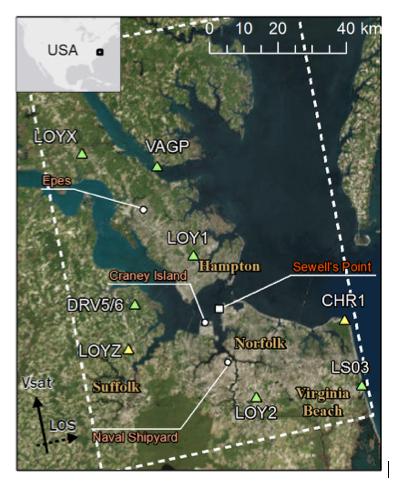
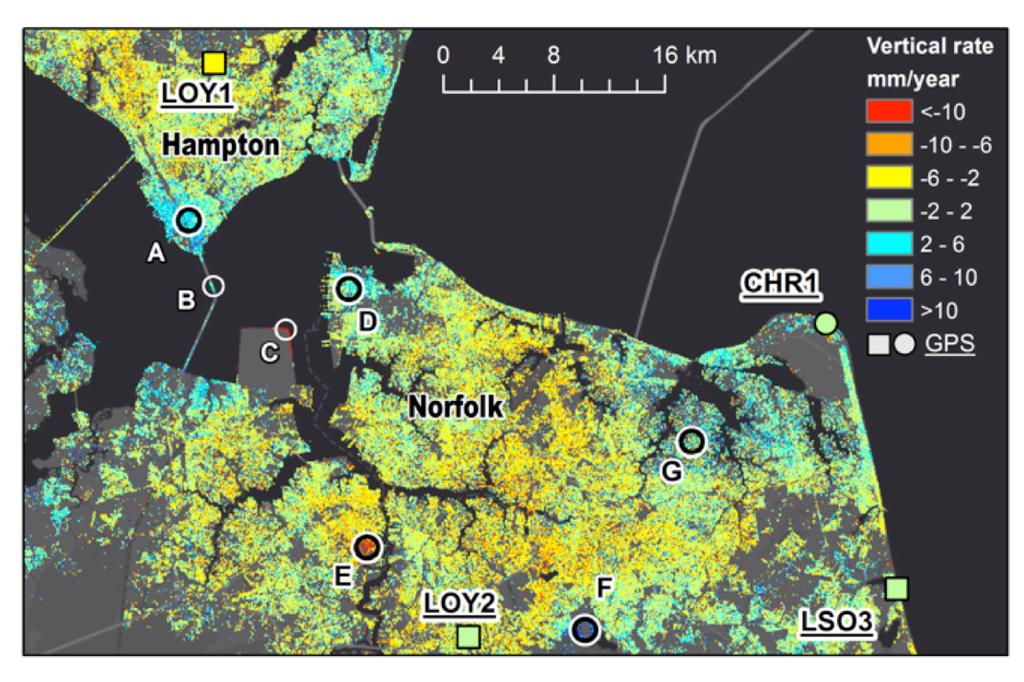
4 Preliminary InSAR Analysis As a starting point, we have performed a preliminary InSAR analysis for the region. Goals: Analyze available (free) historical SAR data with state-of-the-art InSAR techniques to compute an initial subsidence rate map. Understand the uncertainties associated with performing the analysis of our region. Establish a system that provide ongoing subsidence monitoring in the region. Using ISCE and StaMPS, we have analyzed two scenes over Hampton Roads using ALOS-1 data from InSAR provides relative rates we have gone one step further to compute absolute rates by tying into the available GPS data in the region.
5
6
7
8 Draft Figure Draft Figure

9
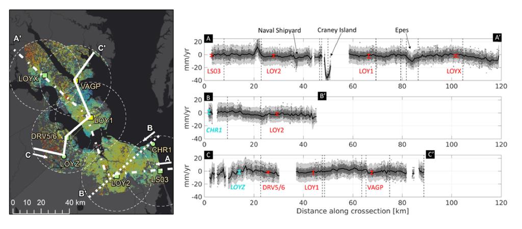
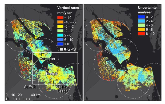
10
11
12
 is a European Space Agency (ESA) mission that was launched in 2014.")
13 Ongoing Monitoring One of the primary goals of this project is to create the capacity within Hampton Roads to conduct ongoing subsidence monitoring as needed or requested. Many different SAR satellites have been launched or are being launched to dramatically improve the coverage. Sentinel-1 (C-band) is a European Space Agency (ESA) mission that was launched in The NASA-ISRO (NISAR) satellite will launch in Providing near global coverage of world s coastlines, including Hampton Roads. We have begun processing the Sentinel-1 data with the aim of constructing a system that can be updated on a regular basis and provide user-friendly output.
14 Improvement with Sentinel-1 (C-band)
15 NASA Sea Level Change Team (N-SLCT) New N-SLCT was selected recently (objectives below). 1. Characterizing current changes in sea level: Global and regional sea level projections that extrapolate from satellite and contemporary observations 2. Characterizing underlying processes and improving predictions of regional variations in sea level 3. Improving knowledge of ice mass change that specifically improves estimates of current and future sea level rise 4. Integrating these results into better forecasts of sea level rise.

16 NASA Sea Level Change Team (N-SLCT) Focus will be on using satellite data to improve regional relative sea level projections. Part of this includes identifying ways to perform InSAR analysis on very large spatial scales very quickly and how tie this in with ocean variability. Hampton Roads is going to serve as one of the test cases. Web portal with output from team at: sealevel.nasa.gov
17 Summary Initial analysis of the ALOS data indicates spatial variability in vertical land motion à needs further investigation due to uncertainties. InSAR is constraining the short spatial scales (<20 km) well, show large localized subsidence signals larger than the uncertainty (Craney Island: -18 +/- 8 mm/year). Problems: Significant atmospheric noise super-imposed on subsidence signal. Too few acquisitions to reduce long-wavelength noise. If interested in absolute rates, lack of GPS coverage in the area. We have started analyzing the available Sentinel-1 data. Additional year of the project being supported by NASA and CCRFR at ODU. Significantly reduced uncertainty/noise in the generated subsidence maps. To generate absolute velocities with low uncertainty, improved GPS coverage is needed. With Sentinel-1 still on orbit, new subsidence maps can be generated each month, leading to ongoing monitoring of subsidence in the region. This effort will be tied into the broader NASA effort.
Subsidence Monitoring in Hampton Roads Using Satellites
 ODU Digital Commons July 29, 2016: The Latest in Sea Level Rise Science Hampton Roads Sea Level Rise/Flooding Adaptation Forum 7-29-2016 Subsidence Monitoring in Hampton Roads Using Satellites Ben Hamlington
Sentinel-1 Mission Status
 Sentinel-1 Mission Status Pierre Potin, Sentinel-1 Mission Manager 5TH GEOGLAM RAPP Workshop 16-17 May 2017, ESRIN Sentinel-1: Copernicus radar imaging mission for ocean, land, emergency Part of the Copernicus
Infrastructure monitoring using SAR interferometry
 Infrastructure monitoring using SAR interferometry Hossein Nahavandchi Roghayeh Shamshiri Norwegian University of Science and Technology (NTNU), Department of Civil and Environmental Engineering Geodesy
Dual-Frequency Ku- Band Radar Mission Concept for Snow Mass
 Dual-Frequency Ku- Band Radar Mission Concept for Snow Mass Chris Derksen Environment and Climate Change Canada Study Team: Climate Research Division/Meteorological Research Division, ECCC Canadian Space
Copernicus Today and Tomorrow GEO Week Group on Earth Observation Geneva, 16 January 2014 The Copernicus Space Infrastructure
 Copernicus Today and Tomorrow GEO Week Group on Earth Observation Geneva, 16 January 2014 The Copernicus Space Infrastructure Thomas Beer, Policy Coordinator, Copernicus Space Office, ESA-ESRIN, Frascati
Floating Ice: Progress in Addressing Science Goals
 Polar Floating Ice: Progress in Addressing Science Goals Stephen Howell 1, Leif Toudal Pedersen 2 and Roberto Saldo 3 1 Environment Canada, Climate Research Division, Toronto, Canada 2 Danish Meteorological
Canary in the Coal Mine: Subsidence in Coastal Louisiana Press Conference
 Canary in the Coal Mine: Subsidence in Coastal Louisiana Press Conference Samuel Bentley, LSU Department of Geology & Geophysics professor and Billy and Ann Harrison chair in sedimentary geology Mead Allison,
Current and near-future SAR (and LIDAR) systems
 systems") Current and near-future SAR (and LIDAR) systems Ake Rosenqvist solo Earth Observation, Japan Mexico City, Mexico June 7-9, 2016 1 Current and near-future SARs & LIDARs ALOS-2/PALSAR-2 global mosaics SAOCOM-1A/1B
Current and near-future SAR (and LIDAR) systems Ake Rosenqvist solo Earth Observation, Japan Mexico City, Mexico June 7-9, 2016 1 Current and near-future SARs & LIDARs ALOS-2/PALSAR-2 global mosaics SAOCOM-1A/1B
Geohazard Supersites and Natural Laboratories
 Geohazard Supersites and Natural Laboratories FRINGE 2011, Frascati, Italy, September 19, 2011 Wolfgang Lengert, ESA Falk Amelung, University of Miami, GEO task lead Craig Dobson, NASA, CEOS task lead
A state of the art and user driven Copernicus service Physics and Biogeochemistry
 C M E M S P r e s e n t a n d F u t u r e R e q u i r e m e n t s f o r I n - S i t u a n d S a t e l l i t e O b s e r v a t i o n s Antonio REPPUCCI; Pierre Yves LE TRAON Mercator Ocean International
Current Status of the ALOS-2 Operation and PALSAR-2 Calibration Activities
 Current Status of the ALOS-2 Operation and PALSAR-2 Calibration Activities Takeshi Motohka, Ryo Natsuaki, Yukihiro Kankaku, Shinichi Suzuki, Masanobu Shimada (JAXA) Osamu Isoguchi (RESTEC) CEOS SAR CALVAL
Effective Utilization of Synthetic Aperture Radar (SAR) Imagery in Rapid Damage Assessment
 Imagery in Rapid Damage Assessment") Effective Utilization of Synthetic Aperture Radar (SAR) Imagery in Rapid Damage Assessment Case Study Pakistan Floods SUPARCO M. Maisam Raza, Ahmad H. Rabbani SEQUENCE Flood Monitoring using Satellite
Effective Utilization of Synthetic Aperture Radar (SAR) Imagery in Rapid Damage Assessment Case Study Pakistan Floods SUPARCO M. Maisam Raza, Ahmad H. Rabbani SEQUENCE Flood Monitoring using Satellite
Geoscience Australia Report on Cal/Val Activities
 Medhavy Thankappan Geoscience Australia Agency Report I Berlin May 6-8, 2015 Outline 1. Calibration / validation at Geoscience Australia Corner reflector infrastructure for SAR calibration (for information)
Sentinel-1 Mission Status
 Sentinel-1 Mission Status Pierre Potin, Sentinel-1 Mission Manager, ESA Luca Martino, Technical Support Engineer, ESA... and the Sentinel-1 operations team PSTG SAR Coordination Working Group 14 December
C o p e r n i c u s L a n d M o n i t o r i n g S e r v i c e
 C o p e r n i c u s L a n d M o n i t o r i n g S e r v i c e Integration into existing Snow and Ice Services and draft product specifications Annett BARTSCH b.geos Copernicus High Resolution Snow and
Volcanoes Session. Chairs: Y. Fukushima & G. Puglisi
 Volcanoes Session Chairs: Y. Fukushima & G. Puglisi Presentation Summary We had presentations on volcanoes all over the world, more than the last FRINGE workshops: Etna, Campi Flegrei, Ethiopian rift,
Emerging Needs and Opportunities in Ocean Remote Sensing
 Emerging Needs and Opportunities in Ocean Remote Sensing Christine Gommenginger National Oceanography Centre, Southampton With thanks to: Chris Banks, Val Byfield, Paolo Cipollini, Nadim Dayoub, Giuseppe
Emergency Management Service (EMS) mapping
 mapping") GMES Emergency Management Service (EMS) mapping Frédéric BASTIDE GMES unit, European Commission UN-SPIDER Expert Meeting: "Crowdsource Mapping for Disaster Risk Management and Emergency Response" 3-5 December,
GMES Emergency Management Service (EMS) mapping Frédéric BASTIDE GMES unit, European Commission UN-SPIDER Expert Meeting: "Crowdsource Mapping for Disaster Risk Management and Emergency Response" 3-5 December,
Julia Figa-Saldaña & Klaus Scipal
 Julia Figa-Saldaña & Klaus Scipal julia.figa@eumetsat.int klaus.scipal@esa.int Meeting, Outline MetOp/EPS status MetOp/EPS Second Generation status 2016 scatterometer conference Other European ocean programme
Optimizing Observations of Sea Ice Thickness and Snow Depth in the Arctic
 DISTRIBUTION STATEMENT A. Approved for public release; distribution is unlimited. Optimizing Observations of Sea Ice Thickness and Snow Depth in the Arctic Jacqueline A. Richter-Menge CRREL, 72 Lyme Road,
EO4SEE - THE PATHFINDER OF OPERATIONAL SATELLITE MONITORING FOR THE REGION OF THE BLACK SEA AND CENTRAL EUROPE
 EO4SEE: Pathfinder assessment for regional high volume data access, processing and information service delivery platforms - South East Region EO4SEE - THE PATHFINDER OF OPERATIONAL SATELLITE MONITORING
National Satellite Data Centre and Finnish Sentinel Collaborative Ground Segment. Jyri Heilimo Finnish Meteorological Instute
 National Satellite Data Centre and Finnish Sentinel Collaborative Ground Segment Jyri Heilimo Finnish Meteorological Instute Sodankylä National Satellite Data Centre National satellite data centre providing
Changes to Extreme Precipitation Events: What the Historical Record Shows and What It Means for Engineers
 Changes to Extreme Precipitation Events: What the Historical Record Shows and What It Means for Engineers Geoffrey M Bonnin National Oceanic and Atmospheric Administration National Weather Service Office
Earth Science Flight Mission Overview
 Earth Science Flight Mission Overview Nand Topiwala Science Mission Directorate NASA Headquarters April 25, 2007 Earth Science Missions Afternoon Constellation, or A-Train, Multi-Satellite Observatory
The Polar Ice Sheets Monitoring Project A Coordinated Response from Space Agencies
 The Polar Ice Sheets Monitoring Project A Coordinated Response from Space Agencies Yves Crevier / Members of the PSTG SAR Coordination WG Canadian Space Agency CEOS SIT-28 Meeting Hampton, Virginia, USA
Status of EUMETSAT Current and Future Programmes
 Status of EUMETSAT Current and Future Programmes Ernst Koenemann Director Programme Development Spanish Industry Day 15 th Slide: 1 Brief Status of MSG and EPS All operational Missions are performing as
Geohazard Supersites and Natural Laboratories
 Geohazard Supersites and Natural Laboratories FRINGE 2011, Frascati, Italy, September 19, 2011 Wolfgang Lengert, ESA Falk Amelung, University of Miami, GEO task lead Craig Dobson, NASA, CEOS task lead
EUMETSAT Climate Activities
 EUMETSAT Climate Activities Jörg Schulz EUMETSAT s Role in Climate Monitoring EUMETSAT has a prominent role in the world for providing services relevant to climate: EUMETSAT maintains some of the longest
HY-2A Satellite User s Guide
 National Satellite Ocean Application Service 2013-5-16 Document Change Record Revision Date Changed Pages/Paragraphs Edit Description i Contents 1 Introduction to HY-2 Satellite... 1 2 HY-2 satellite data
UN COPUOS 52 nd session of the Scientific and Technical Subcommittee. COPERNICUS - an European Achievement. S. Jutz Head, ESA Copernicus Space Office
 UN COPUOS 52 nd session of the Scientific and Technical Subcommittee COPERNICUS - an European Achievement S. Jutz Head, ESA Copernicus Space Office 11 Feb 2015, Vienna 1 2 What is Copernicus? European
Space research. Horizon Work Programme. "Countdown to Horizon 2020 Space" Earth Observation topics. Brussels, 12 December 2013
 Space research Horizon 2020 - Work Programme "Countdown to Horizon 2020 Space" Earth Observation topics Brussels, 12 December 2013 richard.gilmore@ec.europa.eu Table of contents FP/Copernicus - general
The March 11, 2011, Tohoku-oki earthquake (Japan): surface displacement and source modelling
: surface displacement and source modelling") The March 11, 2011, Tohoku-oki earthquake (Japan): surface displacement and source modelling Salvatore Stramondo Bignami C., Borgstrom S., Chini M., Guglielmino F., Melini D., Puglisi G., Siniscalchi V.,
The March 11, 2011, Tohoku-oki earthquake (Japan): surface displacement and source modelling Salvatore Stramondo Bignami C., Borgstrom S., Chini M., Guglielmino F., Melini D., Puglisi G., Siniscalchi V.,
Long-Term Time Series of Water Vapour Total Columns from GOME, SCIAMACHY and GOME-2
 Graphics: ESA Graphics: ESA Graphics: ESA Long-Term Time Series of Water Vapour Total Columns from GOME, SCIAMACHY and GOME-2 S. Noël, S. Mieruch, H. Bovensmann, J. P. Burrows Institute of Environmental
CGMS-45-WMO-WP-05 Monitoring Extreme Weather and Climate from Space. World Meteorological Organization (WMO) Space Programme
 Space Programme") CGMS-45-WMO-WP-05 Monitoring Extreme Weather and Climate from Space World Meteorological Organization (WMO) Space Programme Introduction UNOSAT Report Satellite Detected Waters over Xieng Ngneun District,
CGMS-45-WMO-WP-05 Monitoring Extreme Weather and Climate from Space World Meteorological Organization (WMO) Space Programme Introduction UNOSAT Report Satellite Detected Waters over Xieng Ngneun District,
C o p e r n i c u s a n d W I G O S
 C o p e r n i c u s a n d W I G O S Jean-Noël Thépaut & Mark Dowell 24 October 2017 GEO XIV, Washington DC, 23-28 October 2017 T h e C o p e r n i c u s P r o g r a m m e Copernicus is the European Union
EUMETSAT Activities Related to Climate
 EUMETSAT Activities Related to Climate Jörg Schulz joerg.schulz@eumetsat.int Slide: 1 What we do USER REQUIREMENTS European National Meteorological Services Operating Agency! European Space Industry Private
Towards eenvironment Prague, March GMES Space Component. Josef Aschbacher Head, ESA GMES Space Office
 Towards eenvironment Prague, 25-27 March 2009 GMES Space Component Josef Aschbacher Head, ESA GMES Space Office Prague from Space Segment 2 05 Nov 2003 CNES 2003 GISAT 2007 ESA GSELAND GMES is an EU led
The ESA Earth observation programmes overview and outlook
 The ESA Earth observation programmes overview and outlook Dr. Volker Liebig Director, ESA EO Programmes ILA 2008, Berlin ENVISAT mission: 6 years! Bam earthquake Tectonic uplift (Andaman) Arctic 2007 First
Current and Upcoming NASA Hurricane Measurement Missions National Hurricane Conference
 NASA Science Mission Directorate Earth Science Division Applied Sciences Program Current and Upcoming NASA Hurricane Measurement Missions National Hurricane Conference April 18, 2017 Formulation Implementation
DLR s TerraSAR-X contributes to international fleet of radar satellites to map the Arctic and Antarctica
 DLR s TerraSAR-X contributes to international fleet of radar satellites to map the Arctic and Antarctica The polar regions play an important role in the Earth system. The snow and ice covered ocean and
DIFFERENTIAL INSAR STUDIES IN THE BOREAL FOREST ZONE IN FINLAND
 DIFFERENTIAL INSAR STUDIES IN THE BOREAL FOREST ZONE IN FINLAND Kirsi Karila (1,2), Mika Karjalainen (1), Juha Hyyppä (1) (1) Finnish Geodetic Institute, P.O. Box 15, FIN-02431 Masala, Finland, Email:
Contribution of Sentinel Asia Activities to Disaster Management in Asia Pacific Region: Sentinel Asia Success Story in the Philippines Project
 Contribution of Sentinel Asia Activities to Disaster Management in Asia Pacific Region: Sentinel Asia Success Story in the Philippines Project Arturo Daag PHIVOLCS, PHILIPPINES 13 October 2015 Bangkok
Automated ocean color product validation for the Southern California Bight
 Automated ocean color product validation for the Southern California Bight Curtiss O. Davis a, Nicholas Tufillaro a, Burt Jones b, and Robert Arnone c a College of Earth, Ocean and Atmospheric Sciences,
ERBE Geographic Scene and Monthly Snow Data
 NASA Contractor Report 4773 ERBE Geographic Scene and Monthly Snow Data Lisa H. Coleman, Beth T. Flug, Shalini Gupta, Edward A. Kizer, and John L. Robbins Science Applications International Corporation
New NASA Ocean Observations and Coastal Applications
 New NASA Ocean Observations and Coastal Applications Duane Armstrong Chief, Applied Science & Technology Project Office August 20, 2014 1 Outline NASA s new Earth Science Ocean Science Missions for 2014
Crowdsourcing approach for large scale mapping of built-up land
 Crowdsourcing approach for large scale mapping of built-up land Kavinda Gunasekara Kavinda@ait.asia Geoinformatics Center Asian Institute of Technology, Thailand. Regional expert workshop on land accounting
U s i n g t h e E S A / E U M E T C A S T N a v i g a t o r s
 U s i n g t h e E S A / E U M E T C A S T N a v i g a t o r s Copernicus User Uptake Information Sessions Copernicus EU Copernicus EU Copernicus EU www.copernicus.eu I N T R O D U C T I O N O F U S E C
Orbit Design Marcelo Suárez. 6th Science Meeting; Seattle, WA, USA July 2010
 Orbit Design Marcelo Suárez Orbit Design Requirements The following Science Requirements provided drivers for Orbit Design: Global Coverage: the entire extent (100%) of the ice-free ocean surface to at
PP HRSST Pilot Programme for High Resolution Sea Surface Temperature. Review objectives Review progress during year Next steps: workplan
 PP HRSST Pilot Programme for High Resolution Sea Surface Temperature Review objectives Review progress during year Next steps: workplan Collaboration between DBCP and GHRSST Drifter SST vital for satellite
Copernicus Overview. Major Emergency Management Conference Athlone 2017
 Copernicus Overview Major Emergency Management Conference Athlone 2017 Copernicus is a European programme implemented by the European Commission. The services address six thematic areas: land, marine,
The Geohazard Supersites and Natural Laboratories (GSNL).
.") The Geohazard Supersites and Natural Laboratories (GSNL). Falk Amelung, University of Miami Mike Poland, Hawaii Volcano Observatory Scott Baker, U of Miami, Unavco Outline: Overview over GSNL (Phase 2)
The Geohazard Supersites and Natural Laboratories (GSNL). Falk Amelung, University of Miami Mike Poland, Hawaii Volcano Observatory Scott Baker, U of Miami, Unavco Outline: Overview over GSNL (Phase 2)
Earth Observation in coastal zone MetOcean design criteria
 ESA Oil & Gas Workshop 2010 Earth Observation in coastal zone MetOcean design criteria Cees de Valk BMT ARGOSS Wind, wave and current design criteria geophysical process uncertainty modelling assumptions
onboard of Metop-A COSMIC Workshop 2009 Boulder, USA
 GRAS Radio Occultation Measurements onboard of Metop-A A. von Engeln 1, Y. Andres 1, C. Cardinali 2, S. Healy 2,3, K. Lauritsen 3, C. Marquardt 1, F. Sancho 1, S. Syndergaard 3 1 2 3 EUMETSAT, ECMWF, GRAS
sentinel-3 A BIGGER PICTURE FOR COPERNICUS
 sentinel-3 A BIGGER PICTURE FOR COPERNICUS SATELLITES TO SERVE By providing a set of key information services for a wide range of practical applications, Europe s Copernicus programme has been put in place
The NASA Soil Moisture Active Passive Mission (SMAP) Status and Early Results
 Status and Early Results") 20154 California Institute of Technology. Government sponsorship acknowledged. National Aeronautics and Space Administration The NASA Soil Moisture Active Passive Mission (SMAP) Status and Early Results
20154 California Institute of Technology. Government sponsorship acknowledged. National Aeronautics and Space Administration The NASA Soil Moisture Active Passive Mission (SMAP) Status and Early Results
Copernicus Overview and Emergency Management Service
 Copernicus Overview and Emergency Management Service Frédéric BASTIDE European Commission Open informal session of the United Nations Inter-Agency Meeting on Outer Space Activities 12 March 2013, Geneva
ALOS-2 Basic Observation Scenario (First Edition) October 10, 2014 JAXA/ALOS-2 Project
 October 10, 2014 JAXA/ALOS-2 Project") ALOS-2 Basic Observation Scenario (First Edition) October 10, 2014 JAXA/ALOS-2 Project 1 Revision details Rev. Date Page Revision details A October 10, 2014 P13,P30 P17 Updated the date of Basic Observation
ALOS-2 Basic Observation Scenario (First Edition) October 10, 2014 JAXA/ALOS-2 Project 1 Revision details Rev. Date Page Revision details A October 10, 2014 P13,P30 P17 Updated the date of Basic Observation
Geophysical Correction Application in Level 2 CryoSat Data Products
 ESRIN-EOP-GQ / IDEAS IDEAS-VEG-IPF-MEM-1288 Version 2.0 29 July 2014 Geophysical Correction Application in Level 2 CryoSat Data Products TABLE OF CONTENTS 1 INTRODUCTION... 3 1.1 Purpose and Scope... 3
New Era of Global Monitoring by ALOS-2: Advanced Land Observing Satellite-2 DAICHI-2 Yuko Suzuki
 New Era of Global Monitoring by ALOS-2: Advanced Land Observing Satellite-2 DAICHI-2 Yuko Suzuki International Relations and Research Department Japan Aerospace Exploration Agency (JAXA) 1 Dawning Era
Interferometric Synthetic Aperture Radar (InSAR) and GGOS. Andrea Donnellan NASA/JPL February 21, 2007
 and GGOS. Andrea Donnellan NASA/JPL February 21, 2007") Interferometric Synthetic Aperture Radar (InSAR) and GGOS Andrea Donnellan NASA/JPL February 21, 2007 Sources for Science Objectives Fourth component of EarthScope Involvement: NSF, NASA, USGS, Universities
Interferometric Synthetic Aperture Radar (InSAR) and GGOS Andrea Donnellan NASA/JPL February 21, 2007 Sources for Science Objectives Fourth component of EarthScope Involvement: NSF, NASA, USGS, Universities
Copernicus Space Component
 Copernicus Space Component Core and Collaborative Ground Segment, Operations Concept, Data Access Simon.Jutz (@esa.int) Head, Copernicus Space Office European Space Agency, Earth Observation Programmes
SAR Coordination for Snow Products
 Polar SAR Coordination Working Meeting 5 SAR Coordination for Snow Products David Small 1, Thomas Nagler 2, David Jäger 1, Christoph Rohner 1, Adrian Schubert 1 1: University of Zurich, Switzerland 2:
Land subsidence induced by groundwater extraction in the Alto Guadalentín aquifer, SE Spain.
 Land subsidence induced by groundwater extraction in the Alto Guadalentín aquifer, SE Spain. Pablo Ezquerro, Marta Béjar-Pizarro, Gerardo Herrera, José A. Fernández Merodo, Roberto Tomás, Carolina Guardiola-Albert,
Gets Boost from a New Satellite
 Earthquake Monitoring Gets Boost from a New Satellite By J. R. Elliott, A. J. Elliott, A. Hooper, Y. Larsen, P. Marinkovic, T. J. Wright Fig. 1. Sentinel-1A interferogram built by comparing scans near
Canadian Space Agency Update. STG 3 ESRIN, Frascati May 5-6, 2008 Yves Crevier
 Canadian Space Agency Update STG 3 ESRIN, Frascati May 5-6, 2008 Yves Crevier Role of CSA in IPY Ensure the use of Space Technologies in IPY Science initiatives Guarantee fluid and continued availability
ESA s supporting Activities Related to Mass Transport in the Earth System
 ESA s supporting Activities Related to Mass Transport in the Earth System Roger Haagmans Mission Science Division European Space Agency Swarm mission: 3D-Mantle Conductivity (A. Jackson ETH Zürich, DNSC,
ALOS-2 Basic Observation Scenario (First Edition) January 10, 2014 JAXA/ALOS-2 Project
 January 10, 2014 JAXA/ALOS-2 Project") ALOS-2 Basic Observation Scenario (First Edition) January 10, 2014 JAXA/ALOS-2 Project 1 1.First edition 2.Purpose and Background 3.Approach of the Basic Observation Scenario 4.Basic Observation
ALOS-2 Basic Observation Scenario (First Edition) January 10, 2014 JAXA/ALOS-2 Project 1 1.First edition 2.Purpose and Background 3.Approach of the Basic Observation Scenario 4.Basic Observation
ECMWF global reanalyses: Resources for the wind energy community
 ECMWF global reanalyses: Resources for the wind energy community (and a few myth-busters) Paul Poli European Centre for Medium-range Weather Forecasts (ECMWF) Shinfield Park, RG2 9AX, Reading, UK paul.poli
VNREDSat-1. Vietnam Natural Resources, Environment and Disaster monitoring Satellite. Lai Anh Khoi SPACE TECHNOLOGY INSTITUTE
 VNREDSat-1 Vietnam Natural Resources, Environment and Disaster monitoring Satellite Lai Anh Khoi SPACE TECHNOLOGY INSTITUTE JPTM2014 Yangon, Nov. 19-21, 2014 General information (1) Project Owner: Vietnam
The O 2 A-band Spectrometer on the NASA Orbiting Carbon Observatory-2 (OCO-2)
") Workshop on Remote sensing in the O 2 A-band The O 2 A-band Spectrometer on the NASA Orbiting Carbon Observatory-2 (OCO-2) David Crisp for the OCO-2 Science Team Jet Propulsion Laboratory, California Institute
Workshop on Remote sensing in the O 2 A-band The O 2 A-band Spectrometer on the NASA Orbiting Carbon Observatory-2 (OCO-2) David Crisp for the OCO-2 Science Team Jet Propulsion Laboratory, California Institute
Breakout Session III Evolving landscapes and global environmental change
 Breakout Session III Evolving landscapes and global environmental change 1. Hydrology and critical zone imaging 2. Glaciology: Instrumenting glaciers and ice sheets 3. Polar networks and glacial isostatic
ALOS PI Symposium 2009, 9-13 Nov 2009 Hawaii MOTION MONITORING FOR ETNA USING ALOS PALSAR TIME SERIES
 ALOS PI Symposium 2009, 9-13 Nov 2009 Hawaii ALOS Data Nodes: ALOS RA-094 and RA-175 (JAXA) MOTION MONITORING FOR ETNA USING ALOS PALSAR TIME SERIES Urs Wegmüller, Charles Werner and Maurizio Santoro Gamma
K&C Phase 4 Status report. Use of short-period ALOS-2 observations for vegetation characterization and classification
 K&C Phase 4 Status report Use of short-period ALOS-2 observations for vegetation characterization and classification Paul Siqueira University of Massachusetts, Amherst Science Team meeting #22 Tokyo, Japan,
Planetary Protection Considerations For Mars 2020
 Considerations For Mars 2020 Catharine A. Conley 13 Nov., 2013 1 COSPAR Policy for Restricted Sample Return and Guidelines for Mars... absolute prohibition of destructive impact upon return, the need for
Contribution to global Earth observation from satellites
 Contribution to global Earth observation from satellites - JAXA s Earth Observation strategy - April 16, 2008 Makoto Kajii Japan Aerospace Exploration Agency Earth Observation Summits and GEOSS 1 st EO
Hyper-Spectral and Copernicus Evolution
 Hyper-Spectral and Copernicus Evolution Antonio Ciccolella - ESA Roma, 1 March 2017 Issue/Revision: 0.0 Reference: ESA UNCLASSIFIED Status: - For Official Use ESA UNCLASSIFIED - For Official Use Hyperspectral
Geodesy. orientation. shape. gravity field
 Geodesy noun Science of measuring the shape, orientation and gravity field of the Earth and how it changes over time. shape orientation gravity field Positioning has always been important Downstream applications
Arctic Observing Systems Challenges, New opportunities and Integration
 Arctic Observing Systems Challenges, New opportunities and Integration Japan Norway Arctic Science Week 03 June 2016 By Stein Sandven, NERSC Building an integrated Arctic Observing System Need to collect,
Status report on current and future satellite systems by EUMETSAT Presented to CGMS-44, Plenary session, agenda item D.1
 Status report on current and future satellite systems by EUMETSAT Presented to CGMS-44, Plenary session, agenda item D.1 CGMS-44-EUMETSAT-WP-19.ppt, version 1 (# 859110), 8 June 2016 MISSION PLANNING YEAR...
Sinéad Louise Farrell1,2,3 Thomas Newman1,2,, Alek Petty 1,2, Jackie Richter-Menge4, Dave McAdoo1,2, Larry Connor2
 Sinéad Louise Farrell1,2,3 Thomas Newman1,2,, Alek Petty 1,2, Jackie Richter-Menge4, Dave McAdoo1,2, Larry Connor2 1 Earth System Science Interdisciplinary Center, University of Maryland, USA 2 NOAA Laboratory
ESA s Earth Observation Programmes
 ESA s Earth Observation Programmes 2015 DRAGON Symposium Interlaken, 23 June 2015 Maurice Borgeaud Head of the Department Science, Applications, and Future Technologies ESA Earth Observation Programmes
NASA Jet Propulsion Laboratory Data Products
 NASA Jet Propulsion Laboratory Data Products 17 April 2014 Emergency Response Spatial Tools Technical Interchange Maggi Glasscoe Margaret.T.Glasscoe@jpl.nasa.gov Sang-Ho Yun Sang-Ho.Yun@jpl.nasa.gov www.nasa.gov
Innovative Ways to Monitor Land Displacement
 ARTICLE Innovative Ways to Monitor Land Displacement When people think about landslides, they usually imagine large mud streams which cause considerable loss of life. Whereas such large-scale disasters
ASCAT NRT Data Processing and Distribution at NOAA/NESDIS
 ASCAT NRT Data Processing and Distribution at NOAA/NESDIS Paul S. Chang, Zorana Jelenak, Seubson Soisuvarn, Qi Zhu Gene Legg and Jeff Augenbaum National Oceanic and Atmospheric Administration (NOAA) National
CNES WGCV-36 Report Cal/Val Activities
 CEOS WGCV Meeting 13-17th May 2013, Shangai, China CNES WGCV-36 Report Cal/Val Activities Bertrand Fougnie, Sophie Lachérade, Denis Jouglet, Eric Péquignot, Aimé Meygret, Patrice Henry CNES 1 Summary Pleiades
Snow Cover Applications: Major Gaps in Current EO Measurement Capabilities
 Snow Cover Applications: Major Gaps in Current EO Measurement Capabilities Thomas NAGLER ENVEO Environmental Earth Observation IT GmbH INNSBRUCK, AUSTRIA Polar and Snow Cover Applications User Requirements
APPENDIX 2 OVERVIEW OF THE GLOBAL PRECIPITATION MEASUREMENT (GPM) AND THE TROPICAL RAINFALL MEASURING MISSION (TRMM) 2-1
 AND THE TROPICAL RAINFALL MEASURING MISSION (TRMM) 2-1") APPENDIX 2 OVERVIEW OF THE GLOBAL PRECIPITATION MEASUREMENT (GPM) AND THE TROPICAL RAINFALL MEASURING MISSION (TRMM) 2-1 1. Introduction Precipitation is one of most important environmental parameters.
APPENDIX 2 OVERVIEW OF THE GLOBAL PRECIPITATION MEASUREMENT (GPM) AND THE TROPICAL RAINFALL MEASURING MISSION (TRMM) 2-1 1. Introduction Precipitation is one of most important environmental parameters.
EUMETSAT SAF NETWORK. Lothar Schüller, EUMETSAT SAF Network Manager
 1 EUMETSAT SAF NETWORK Lothar Schüller, EUMETSAT SAF Network Manager EUMETSAT ground segment overview METEOSAT JASON-2 INITIAL JOINT POLAR SYSTEM METOP NOAA SATELLITES CONTROL AND DATA ACQUISITION FLIGHT
Climate Change in Newfoundland & Labrador
 Climate Change in Newfoundland & Labrador Impacts and Adaptation Newleef Conference 08 October 2015 Met-Ocean Services The Team 55 personnel; 24/7 operational weather forecast desk; Equipment technician
Mars Update. Presented by NASA/JPL Solar System Educator Don W. Brown
 Mars Update Presented by NASA/JPL Solar System Educator Don W. Brown http://www.wired.com/wiredscience/2010/01/gallery-mars/6/ Mariner Mars Climate Orbiter Mars Exploration Rovers Mars Global Surveyor
CopernicusEU. the EU's Earth Observation Programme. Sara Zennaro Atre Delegation of the European Union to Japan
 Copernicus the EU's Earth Observation Programme Sara Zennaro Atre Delegation of the European Union to Japan Status Overview, Sept 2016 & Ocean Policies Seminar 4 October 2016 ollow us on: Copernicus EU
NCC roles in successful disaster response I.R.IRAN
 The Second UN-GGIM-AP Plenary Meeting NCC roles in successful disaster response I.R.IRAN Teheran Iran 28-30 October 2013 Ali Javidaneh Technical Deputy of National Cartographic Center (NCC) Outline Types
Japanese Programs on Space and Water Applications
 Japanese Programs on Space and Water Applications Tamotsu IGARASHI Remote Sensing Technology Center of Japan June 2006 COPUOS 2006 Vienna International Centre Water-related hazards/disasters may occur
Information in Radio Waves
 Teacher Notes for the Geodesy Presentation: Possible discussion questions before presentation: - If you didn t know the size and shape of the Earth, how would you go about figuring it out? Slide 1: Geodesy
SYNERGY OF SATELLITE REMOTE SENSING AND SENSOR NETWORKS ON GEO GRID
 SYNERGY OF SATELLITE REMOTE SENSING AND SENSOR NETWORKS ON GEO GRID National Institute of Advanced Industrial Science and Technology, Japan Yoshio Tanaka (on behalf of AIST GEO Grid team) Contents Brief
Final VRF grids Date: Aug 25, 2011 Author: R. Forsberg, G. Strykowski, O. Andersen
 Final VRF grids Date: Aug 25, 2011 Author: R. Forsberg, G. Strykowski, O. Andersen www.blast-project.eu 1 Authors Name Organisation Rene Forsberg National Space Institute, DTU G. Strykowski National Space
Long term performance monitoring of ASCAT-A
 Long term performance monitoring of ASCAT-A Craig Anderson and Julia Figa-Saldaña EUMETSAT, Eumetsat Allee 1, 64295 Darmstadt, Germany. Abstract The Advanced Scatterometer (ASCAT) on the METOP series of
Ocean currents from altimetry
 Ocean currents from altimetry Pierre-Yves LE TRAON - CLS - Space Oceanography Division Gamble Workshop - Stavanger,, May 2003 Introduction Today: information mainly comes from in situ measurements ocean
Earth Observatory of Singapore. Nina Lin 22 Jan 2018
 Earth Observatory of Singapore Nina Lin 22 Jan 2018 EOS Our Mission Our Mission Director Prof. Kerry Sieh The Earth Observatory of Singapore conducts fundamental research on earthquakes, volcanic eruptions,
Polar Space Task Group Permafrost Review of Requirements, Achievements and Expected Data
 Permafrost Review of Requirements, Achievements and Expected Data Annett Bartsch HORIZON2020 project NUNATARYUK (lead AWI with focus on coastal erosion and infrastructure) Dedicated Pleiades acquisitions