Modeling Salinity Distribution in Apalachicola Bay, Florida
|
|
|
- Jemimah Ryan
- 6 years ago
- Views:
Transcription
1 Modeling Salinity Distribution in Apalachicola Bay, Florida Factors Affecting Salinity Distribution in Apalachicola Bay: Freshwater Inflow Apalachicola River Lake Lanier Precipitation Wind Hurricane Climate Change Sea Level Rise Vladimir Paramygin and Y. Peter Sheng Civil and Coastal Engineering Department University of Florida Second Water Institute Symposium February 24, 2010 University of Florida

2 Apalachicola-Chattahoochee-Flint Watershed
3 Rationale of This Study Reduced freshwater inflow leads to higher salinity inside the Bay, The problem worsens during drought and reduced flow from Lake Lanier, High salinity damages the oyster farming industry, Flow in the Apalachicola River affects the spawning of Gulf sturgeon, Climate change and sea level rise can cause salt intrusion and higher salinity inside the Bay and the River. An integrated modeling system of the Apalachicola-Chattahoochee-Flint (ACF) is needed to assess the impact of freshwater withdrawal and climate change on the salinity distribution inside the Apalachicola Bay and fishery (oyster inside the Bay and Gulf sturgeon inside the River). Apalachicola Bay model + Apalachicola River model + ACF River System model
4 Water War Georgia, Alabama and Florida's twenty year battle for water escalated to unprecedented level a few years ago. On July 17, 2009 a district court judge ruled that metro Atlanta has been illegally withdrawing drinking water from a federally owned reservoir known as Lake Lanier. Officials in Alabama and Florida accuse Georgia of mismanaging its water resources, causing their states to lose out on much needed water. Now the race is on for all three states to negotiate a water sharing agreement, or for Georgia to gain Congressional approval to continue to withdraw water from Lanier. If a solution cannot be reached by July of 2012, then metro Atlanta risks having its main water supply cut off.
5 Journal of Shellfish Research, Vol. 26, No. 1, , 2007 HAPLOSPORIDIUM NELSONI (MSX) rdna DETECTED IN OYSTERS FROM THE GULF OF MEXICO AND THE CARIBBEAN SEA P. N. ULRICH,1,2* C. M. COLTON,2 C. A. HOOVER,2 P. M. GAFFNEY2 AND A. G. MARS The known range of the oyster pathogen Haplosporidium nelsoni Haskin, Stauber, and Mackin (MSX) extends along the North American Atlantic coast from Nova Scotia to Florida. Our study demonstrates that H. nelsoni is also present throughout the Gulf of Mexico. Thirty of 41 oysters (73%) sampled from sites ranging from Florida to as far south as Venezuela were positive for MSX by PCR amplification of the ribosomal rrna gene complex.
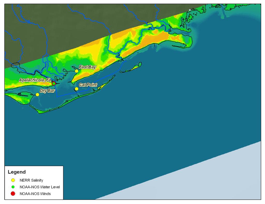
6 -Use CH3D (Curvilinear-grid Hydrodynamics in 3D) for hydrodynamic and salinity simulation -CH3D Grid for the Apalachicola Bay - Period of simulation 2004 hurricane season - Initial and boundary conditions -Tides -Wind speed -River flows - Simulated water level NOAA data - Simulated salinity ANERR data
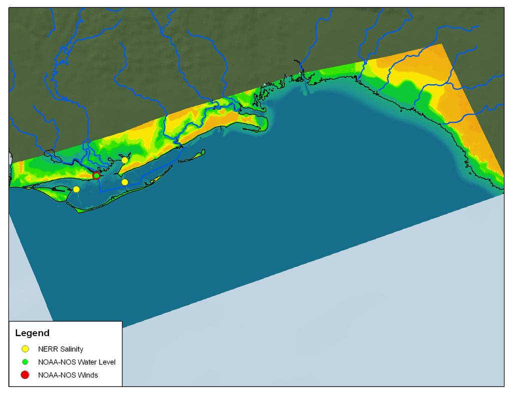
7 CH3D Grid
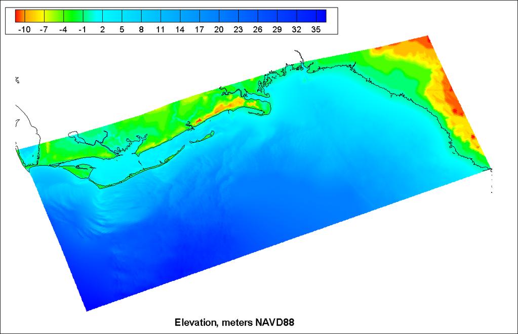
8 CH3D Grid
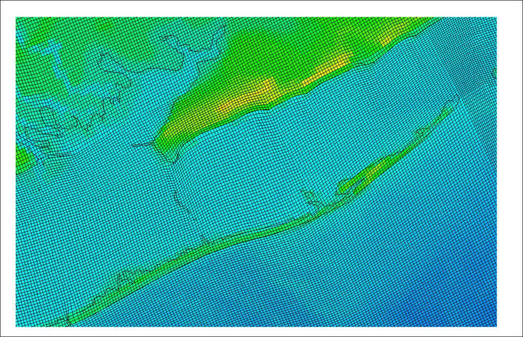
9 CH3D Grid
10 Period of simulation May 1, 2004 July 15, 2004 salinity spin-up (2.5 months) July 15, 2004 October 15, 2004 simulation (3 months) Bonnie: Aug 3 Aug 13 Charley: Aug 9 Aug 15 Frances: Aug 24 Sep 10 Ivan: Sep 2 Sep 24 Jeanne: Sep 13 Sep 28

11 2004 Tropical Storms
12 CH3D Grid
13 Boundary conditions Winds Based on NOGAPS winds WMS was used to blend two wind fields H*Wind allows for better representation of storms Tidal open boundary is based on the following tidal constituents: M2, N2, K1, S2, O1, K2, Q1 SSA, SA Salinity open boundary condition is based on HYCOM data at the following depths (in meters): 0.0, 10.0, 20.0, 30.0, 50.0, 75.0, 100.0, 125.0, 150.0, 200.0, 250.0, 300.0
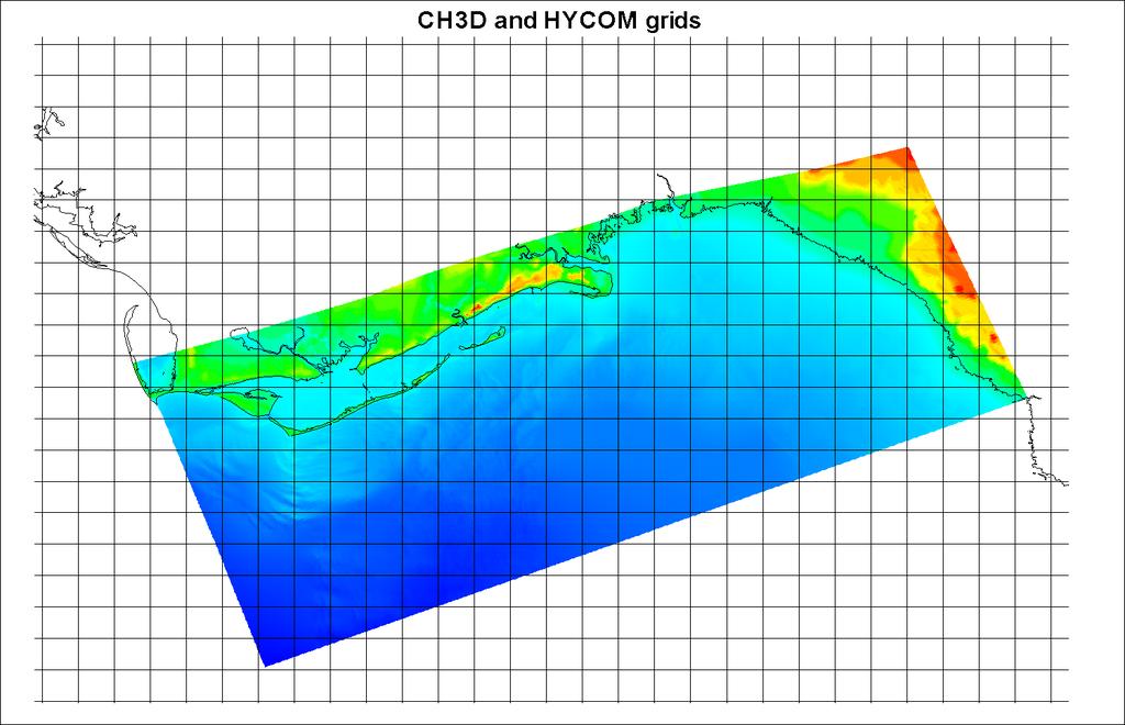
14 CH3D-HYCOM Grids
15 Wind Speed, m/s Wind Speed. Apalachicola River Station WindSpeed Ivan Frances Jeanne Bonnie Date
16 Wind speed, m/s Wind speed, m/s Wind Speed. Apalachicola River Station m/s Apalachicola River. Winds. Measured Ivan Bonnie Jeanne Frances Date m/s Apalachicola River. Winds. Simulation Date
17 River Flows East Bay (near High Bluff) Based on precipitation / simulated data fit during spin-up period Apalachicola River Based on USGS data


18 Surface Precipitation based on CFSR Data 09/05/ /05/2010
19 Water level, cm (NAVD88) Simulated Water Level at Apalachicola River Measured Predicted Simulated Date
20 Salinity Simulations Base Normal conditions, based on the data Scenario 1 +1 meter elevation at open boundary Scenario 2 50% river flow reduction
21 Base Simulation. Salinity. Dry Bar
22 Base Simulation. Salinity. Cat Point
23 Wind Speed, m/s Base Simulation. Salinity. East Bay WindSpeed Ivan Frances Jeanne Bonnie Date
24 Scenario #1. Simulation. Salinity. Dry Bar
25 Surface Salinity. Post-Frances

26 Surface Salinity. Post-Jeanne
27 Scenario #1. Simulation. Salinity. Cat Point
28 Scenario #1. Simulation. Salinity. East Bay

29 Scenario #2 Simulation. Salinity. Dry Bar
30 Scenario #2 Simulation. Salinity. Cat Point
31 Scenario #2 Simulation. Salinity. East Bay
32 Summary A preliminary hydrodynamic-salinity model of the Apalachicola Bay is developed and validated with data during 2004 hurricane season. Salinity decreased right after the hurricanes, but recovered quickly. 50% reduction in freshwater flow or sea level rise (1 m) will significantly increase the salinity inside the Bay. The model will be extended into the Apalachicola River and coupled to the ACF River System model of Georgakakos. The hydrodynamic-salinity model could be expanded to include water quality and nutrient model (CH3D-IMS) and fishery model (Pine) to assess the impact of freshwater withdrawal and climate change on the Apalachicola Bay and Apalachicola River ecosystem
33
National Integrated Drought Information System Southeast US Pilot for Apalachicola- Flint-Chattahoochee River Basin. 22 May 2012
 National Integrated Drought Information System Southeast US Pilot for Apalachicola- Flint-Chattahoochee River Basin 22 May 2012 Outline Welcome Keith Ingram, UF, Southeast Climate Consortium Current drought
Drought Early Warning for the Apalachicola- Chattahoochee-Flint River Basin 20 December 2016
 National Integrated Drought Information System Drought Early Warning for the Apalachicola- Chattahoochee-Flint River Basin 20 December 2016 If you are new to the webinar: For audio: Dial in: 877-922-7940
2004 Hurricane Season: Climate Overview and Lessons Learned
 2004 Hurricane Season: Climate Overview and Lessons Learned Mark Saunders, PhD (Presenter: Milan Simic,, PhD, Benfield) Lead Scientist, Tropical Storm Risk Benfield Hazard Research Centre University College
National Integrated Drought Information System. Southeast US Pilot for Apalachicola- Flint-Chattahoochee River Basin 20-March-2012
 National Integrated Drought Information System Southeast US Pilot for Apalachicola- Flint-Chattahoochee River Basin 20-March-2012 Current drought status from Drought Monitor http://www.drought.unl.edu/dm/monitor.html
Southeast US Pilot for Apalachicola- Flint-Chattahoochee River Basin
 National Integrated Drought Information System Southeast US Pilot for Apalachicola- Flint-Chattahoochee River Basin 11 February 2014 Outline Welcome Keith Ingram, Southeast Climate Consortium Current drought
There was a big difference in rainfall patterns during the month of May across the ACF basin. The image to the left indicates either a surplus or
 There was a big difference in rainfall patterns during the month of May across the ACF basin. The image to the left indicates either a surplus or deficit of rainfall for the month. Note that northern reaches
Coastal Inundation Risk for SE Florida Incorporating Climate Change Impact on Hurricanes & Sea Level Rise
 Coastal Inundation Risk for SE Florida Incorporating Climate Change Impact on Hurricanes & Sea Level Rise Y. Peter Sheng and V.A. Paramygin Justin R. Davis, Andrew Condon, Andrew Lapetina, Tianyi Liu,
Monthly Long Range Weather Commentary Issued: SEPTEMBER 19, 2016 Steven A. Root, CCM, Chief Analytics Officer, Sr. VP,
 Monthly Long Range Weather Commentary Issued: SEPTEMBER 19, 2016 Steven A. Root, CCM, Chief Analytics Officer, Sr. VP, sroot@weatherbank.com SEPTEMBER 2016 Climate Highlights The Month in Review The contiguous
Extreme Weather and Climate Change: the big picture Alan K. Betts Atmospheric Research Pittsford, VT NESC, Saratoga, NY
 Extreme Weather and Climate Change: the big picture Alan K. Betts Atmospheric Research Pittsford, VT http://alanbetts.com NESC, Saratoga, NY March 10, 2018 Increases in Extreme Weather Last decade: lack
WIND EFFECTS ON CHEMICAL SPILL IN ST ANDREW BAY SYSTEM
 WIND EFFECTS ON CHEMICAL SPILL IN ST ANDREW BAY SYSTEM PETER C. CHU, PATRICE PAULY Naval Postgraduate School, Monterey, CA93943 STEVEN D. HAEGER Naval Oceanographic Office, Stennis Space Center MATHEW
Sea Level Rise and Hurricane Florence storm surge research methodology
 Sea Level Rise and Hurricane Florence storm surge research methodology Hurricane Florence storm surge analysis was conducted using a variety of input sources. In order to determine the maximum storm surge
Lecture #18 (April 12, 2010, Monday) Tropical Storms & Hurricanes Part 3. Hurricane Floyd September 15, 1999
 Tropical Storms & Hurricanes Part 3. Hurricane Floyd September 15, 1999") Lecture #18 (April 12, 2010, Monday) Tropical Storms & Hurricanes Part 3 Hurricane Floyd September 15, 1999 Tropical Cyclone Names Names are given to distinguish storms and for ease of communication. Names
Lecture #18 (April 12, 2010, Monday) Tropical Storms & Hurricanes Part 3 Hurricane Floyd September 15, 1999 Tropical Cyclone Names Names are given to distinguish storms and for ease of communication. Names
Mobile District River System Status for October 25, 2018
 Mobile District River System Status for October 25, 2018 Weather Update The Quantitative Precipitation Forecast (QPF) in Figure 1 shows 0.4 to 2.5 inches of precipitation forecasted for the next 7 days.
Estuarine Response in Northeastern Florida Bay to Major Hurricanes in 2005
 Estuarine Response in Northeastern Florida Bay to Major s in 25 By Jeff Woods and Mark Zucker s and tropical storms are critical components of the south Florida hydrologic cycle. These storms cause dramatic
Extreme Rainfall in the Southeast U.S.
 Extreme Rainfall in the Southeast U.S. David F. Zierden Florida State Climatologist Center for Ocean Atmospheric Prediction Studies The Florida State University March 7, 2016 Causes of Extreme Rainfall
Mobile District River System Status for November 17, 2017
 Mobile District River System Status for November 17, 2017 Weather Update The Quantitative Precipitation Forecast (QPF) in Figure 1 shows forecasted precipitation for the next 7 days. Figure 2 shows the
Semi-enclosed seas. Estuaries are only a particular type of semi-enclosed seas which are influenced by tides and rivers
 Semi-enclosed seas Estuaries are only a particular type of semi-enclosed seas which are influenced by tides and rivers Other semi-enclosed seas vary from each other, mostly by topography: Separated from
Development of Operational Storm Surge Guidance to Support Total Water Predictions
 Development of Operational Storm Surge Guidance to Support Total Water Predictions J. Feyen 1, S. Vinogradov 1,2, T. Asher 3, J. Halgren 4, Y. Funakoshi 1,5 1. NOAA/NOS//Development Laboratory 2. ERT,
SUWANNEE RIVER WATER MANAGEMENT DISTRICT 9225 CR 49 LIVE OAK FLORIDA DECEMBER 2015
 HYDRODYNAMIC MODEL DEVELOPMENT, CALIBRATION, AND MFL FLOW REDUCTION AND SEA LEVEL RISE SIMULATION FOR THE TIDAL PORTION OF THE ECONFINA RIVER ECONFINA RIVER, FLORIDA SUWANNEE RIVER WATER MANAGEMENT DISTRICT
HURRICANE FRANCES CHARACTERISTICS and STORM TIDE EVALUATION
 HURRICANE FRANCES CHARACTERISTICS and STORM TIDE EVALUATION ((DRAFT)) By Robert Wang and Michael Manausa Sponsored by Florida Department of Environmental Protection, Bureau of Beaches and Coastal Systems
Rainfall Observations in the Loxahatchee River Watershed
 Rainfall Observations in the Loxahatchee River Watershed Richard C. Dent Loxahatchee River District September 1997 Introduction Rain is a common occurrence in south Florida, yet its presence or absence
Monthly Long Range Weather Commentary Issued: APRIL 18, 2017 Steven A. Root, CCM, Chief Analytics Officer, Sr. VP,
 Monthly Long Range Weather Commentary Issued: APRIL 18, 2017 Steven A. Root, CCM, Chief Analytics Officer, Sr. VP, sroot@weatherbank.com MARCH 2017 Climate Highlights The Month in Review The average contiguous
Analysis of Tides and Storm Surge from Observational Records in the Delaware Inland Bays
 Analysis of Tides and Storm Surge from Observational Records in the Delaware Inland Bays John Callahan Delaware Geological Survey Coastal GeoTools Conference March 30 April 2, 2015 Charleston, SC Outline
South San Francisco Bay Shoreline Studies for EIA 11 with Project Conditions
 South San Francisco Bay Shoreline Studies for EIA 11 with Project Conditions U.S. Army Corps of Engineers San Francisco District Ms. Lisa Andes Mr. Craig Conner Dr. Frank Wu Dr. Jen-Men Lo Dr. Michael
Hurricane Wilma Post Storm Data Acquisition Estimated Peak Wind Analysis and Storm Tide Data. December 27, 2005
 Hurricane Wilma Post Storm Data Acquisition Estimated Peak Wind Analysis and Storm Tide Data December 27, 2005 Hurricane Wilma was the sixth major hurricane of the record-breaking 2005 Atlantic hurricane
TROPICAL CYCLONES IN A WARMER WORLD
 TROPICAL CYCLONES IN A WARMER WORLD Dr Mark Saunders Benfield Hazard Research Centre Department of Space and Climate Physics University College London Workshop for Under 35s Reinsurance Group 14th October
Everglades National Park
 National Park Service U.S. Department of the Interior Water Budget, Climate Variability, and Predicting Salinity for Eastern Florida Bay Erik Stabenau and Kevin Kotun National Park Service Erik_Stabenau@nps.gov
Modeling Hydrodynamic Effects and Salinity Intrusion. Presented by Dr. Eric Swain, USGS Water Science Center, Fort Lauderdale Florida
 Modeling Hydrodynamic Effects and Salinity Intrusion Presented by Dr. Eric Swain, USGS Water Science Center, Fort Lauderdale Florida Requirements Because coastal South Florida has unique features such
Summary of 2004 Atlantic Tropical Cyclone Season and Verification of Authors Seasonal Forecasts
 Summary of 2004 Atlantic Tropical Cyclone Season and Verification of Authors Seasonal Forecasts Issued: 31st January 2005 by Drs Mark Saunders and Adam Lea Benfield Hazard Research Centre, UCL (University
Monthly Long Range Weather Commentary Issued: February 15, 2015 Steven A. Root, CCM, President/CEO
 Monthly Long Range Weather Commentary Issued: February 15, 2015 Steven A. Root, CCM, President/CEO sroot@weatherbank.com JANUARY 2015 Climate Highlights The Month in Review During January, the average
March 5, Are Weather Patterns Becoming More Volatile? MMRMA 2015 Risk Management Workshop
 Are Weather Patterns Becoming More Volatile? MMRMA 2015 Risk Management Workshop Josh Darr Meteorologist and VP Catastrophe Risk Management GLOBAL TEMPERATURES SINCE 1880 EARTH TEMPERATURE RECORDS SINCE
UNDERSTANDING STORM TIDES
 UNDERSTANDING STORM TIDES Run from the water, hide from the wind.. CATEGORY CATEGORY CATEGORY CATEGORY CATEGORY 1 2 3 4 5 WIND 74-95 mph 64-82 knots 96-110 mph 83-95 knots 111-130 mph 96-113 knots 131-155
Moving Freshwater to the Ocean: Hydrology-Ocean Model Coupling
 Moving Freshwater to the Ocean: Hydrology-Ocean Model Coupling Cheryl Ann Blain 1, Tim Campbell 1, Song Yang 2, Aubrey Dugger 3, Paul Martin 1, Tommy Jenson 1 Naval Research Laboratory 1 Oceanography Division,
COASTAL DATA APPLICATION
 2015 Coastal GeoTools Proactive By Design. Our Company Commitment COASTAL DATA APPLICATION Projecting Future Coastal Flood Risk for Massachusetts Bay Bin Wang, Tianyi Liu, Daniel Stapleton & Michael Mobile
9 th INTECOL Orlando, Florida June 7, 2012
 Restoration of the Everglades Saline Wetlands and Florida Bay: Responses Driven from Land and Sea David Rudnick 1, Colin Saunders 2, Carlos Coronado 2, Fred Sklar 2 Erik Stabenau 1, Vic Engel 1, Rene Price
Enhancing predictability of the Loop Current variability using Gulf of Mexico Hycom
 Enhancing predictability of the Loop Current variability using Gulf of Mexico Hycom Matthieu Le Hénaff (1) Villy Kourafalou (1) Ashwanth Srinivasan (1) Collaborators: O. M. Smedstad (2), P. Hogan (2),
Coastal Oceanography. Coastal Oceanography. Coastal Waters
 Coastal Oceanography Coastal Oceanography 95% of ocean life is in coastal waters (320 km from shore) Estuaries and wetlands are among most productive ecosystems on Earth Major shipping routes, oil and
Homework 9: Hurricane Forecasts (adapted from Pipkin et al.)
") November 2010 MAR 110 HW9 Hurricane Forecasts 1 Homework 9: Hurricane Forecasts (adapted from Pipkin et al.) Movement of Hurricanes The advance of a tropical storm or hurricane is controlled by the prevailing
November 2010 MAR 110 HW9 Hurricane Forecasts 1 Homework 9: Hurricane Forecasts (adapted from Pipkin et al.) Movement of Hurricanes The advance of a tropical storm or hurricane is controlled by the prevailing
The Delaware Environmental Monitoring & Analysis Center
 The Delaware Environmental Monitoring & Analysis Center Tina Callahan Delaware Estuary Science & Environmental Summit 2013 January 27-30, 2013 What is DEMAC? Delaware Environmental Monitoring & Analysis
Physical Processes: What have we learned about Florida Bay in the past five years, and how is that useful to CERP planning and SFER management?
 Physical Processes: What have we learned about Florida Bay in the past five years, and how is that useful to CERP planning and SFER management? Peter B. Ortner, UM/RSMAS/CIMAS Modeling Progress Statistical
Observed Climate Variability and Change: Evidence and Issues Related to Uncertainty
 Observed Climate Variability and Change: Evidence and Issues Related to Uncertainty David R. Easterling National Climatic Data Center Asheville, North Carolina Overview Some examples of observed climate
HURRICANE IVAN CHARACTERISTICS and STORM TIDE EVALUATION
 HURRICANE IVAN CHARACTERISTICS and STORM TIDE EVALUATION By Robert Wang and Michael Manausa Sponsored by Florida Department of Environmental Protection, Bureau of Beaches and Coastal Systems Submitted
Simulation of storm surge and overland flows using geographical information system applications
 Coastal Processes 97 Simulation of storm surge and overland flows using geographical information system applications S. Aliabadi, M. Akbar & R. Patel Northrop Grumman Center for High Performance Computing
Societal impacts of inland moving tropical cyclones across the southeastern U.S
 Societal impacts of inland moving tropical cyclones across the southeastern U.S Maggie M. Kovach, Gretchen Carlson, Charles E. Konrad II NOAA Southeast Regional Climate Center Department of Geography University
HURRICANE JEANNE CHARACTERISTICS and STORM TIDE EVALUATION
 HURRICANE JEANNE CHARACTERISTICS and STORM TIDE EVALUATION ((DRAFT)) By Robert Wang and Michael Manausa Sponsored by Florida Department of Environmental Protection, Bureau of Beaches and Coastal Systems
A Statistical-Dynamical Seasonal Forecast of US Landfalling TC Activity
 A Statistical-Dynamical Seasonal Forecast of US Landfalling TC Activity Johnny Chan and Samson K S Chiu Guy Carpenter Asia-Pacific Climate Impact Centre City University of Hong Kong Research sponsored
30 If Vmax > 150, HSI intensity pts = 25
 Hurricane Severity Index: A New Way of Estimating a Tropical Cyclone s Destructive Potential 1. Introduction Christopher G. Hebert*, Robert A. Weinzapfel*, Mark A. Chambers* Impactweather, Inc., Houston,
Climate Outlook through 2100 South Florida Ecological Services Office Vero Beach, FL September 9, 2014
 Climate Outlook through 2100 South Florida Ecological Services Office Vero Beach, FL September 9, 2014 Short Term Drought Map: Short-term (
2006 ATLANTIC HURRICANE SUMMARY. Weather Research Center Houston, Texas
 2006 ATLANTIC HURRICANE SUMMARY Weather Research Center Houston, Texas Weather Research Center 5104 Caroline Houston, Texas 77004 Phone: 713-529-3076 Fax: 713-528-3538 E-mail: wrc@wxresearch.org 2006 Atlantic
Current Climate Science and Climate Scenarios for Florida
 Current Climate Science and Climate Scenarios for Florida Daniel Bader and Vivien Gornitz Water Utilities and Climate Change Workshop Palm Beach County Water Utilities/ Water Research Foundation June 10,
Draft for Discussion 11/11/2016
 Coastal Risk Consulting (CRC) Climate Vulnerability Assessment for Village of Key Biscayne Deliverable 1.1 in Statement of Work. Preliminary Vulnerability Assessment Identifying Flood Hotspots Introduction...
NOAA National Centers for Environmental Information State Summaries 149-TX. Observed and Projected Temperature Change
 19-TX TEXAS Key Messages Mean annual temperature has increased by approximately 1 F since the first half of the th century. Under a higher emissions pathway, historically unprecedented warming is projected
Sea-level Rise on Cape Cod: How Vulnerable Are We? Rob Thieler U.S. Geological Survey Woods Hole, MA
 Sea-level Rise on Cape Cod: How Vulnerable Are We? Rob Thieler U.S. Geological Survey Woods Hole, MA Outline Sea-level and coastal processes Past sea-level change Predictions for the future Coastal responses
Hurricanes and Storm Surge : Before coming to lab, visit the following web site:
 Geol 108 Lab #7 Week of October 15-19, 2012 Coastal Studies Hurricanes and Storm Surge : Before coming to lab, visit the following web site: http://www.usatoday.com/graphics/weather/gra/gsurge/flash.htm
Modeling Nearshore Waves for Hurricane Katrina
 Modeling Nearshore Waves for Hurricane Katrina Jane McKee Smith US Army Engineer Research & Development Center Coastal and Hydraulics Laboratory Outline Introduction Modeling Approach Hurricane Katrina
Everglades National Park
 National Park Service U.S. Department of the Interior Climate Variability and the Coastal Physical Environment (Florida Bay) Presented by: Erik Stabenau - National Park Service Contributions from: Christina
Climate. Annual Temperature (Last 30 Years) January Temperature. July Temperature. Average Precipitation (Last 30 Years)
 January Temperature. July Temperature. Average Precipitation (Last 30 Years)") Climate Annual Temperature (Last 30 Years) Average Annual High Temp. (F)70, (C)21 Average Annual Low Temp. (F)43, (C)6 January Temperature Average January High Temp. (F)48, (C)9 Average January Low Temp.
Climate Annual Temperature (Last 30 Years) Average Annual High Temp. (F)70, (C)21 Average Annual Low Temp. (F)43, (C)6 January Temperature Average January High Temp. (F)48, (C)9 Average January Low Temp.
Missouri River Basin Water Management
 Missouri River Basin Water Management US Army Corps of Engineers Missouri River Navigator s Meeting February 12, 2014 Bill Doan, P.E. Missouri River Basin Water Management US Army Corps of Engineers BUILDING
Technical Notes: Magnitude and Return Period of 2004 Hurricane Rainfall in Florida
 Journal of Floodplain Management Floodplain Management Association NOV. 2005 Vol. 5, No. 1 Glenn Tootle 1 Thomas Mirti 2 Thomas Piechota 3 Technical Notes: Magnitude and Return Period of 2004 Hurricane
SoFLA-HYCOM (South Florida HYCOM) Regional Model around Florida Straits, Florida Bay and the Florida Keys: An overview FLORIDA.
 Regional Model around Florida Straits, Florida Bay and the Florida Keys: An overview FLORIDA.") SoFLA-HYCOM (South Florida HYCOM) Regional Model around Florida Straits, Florida Bay and the Florida Keys: An overview SW Florida shelf FLORIDA Florida Current B A H A M A S 25N CUBA 83W 79W Villy KOURAFALOU
SoFLA-HYCOM (South Florida HYCOM) Regional Model around Florida Straits, Florida Bay and the Florida Keys: An overview SW Florida shelf FLORIDA Florida Current B A H A M A S 25N CUBA 83W 79W Villy KOURAFALOU
Changing Hydrology under a Changing Climate for a Coastal Plain Watershed
 Changing Hydrology under a Changing Climate for a Coastal Plain Watershed David Bosch USDA-ARS, Tifton, GA Jeff Arnold ARS Temple, TX and Peter Allen Baylor University, TX SEWRU Objectives 1. Project changes
What is happening to the Jamaican climate?
 What is happening to the Jamaican climate? Climate Change and Jamaica: Why worry? Climate Studies Group, Mona (CSGM) Department of Physics University of the West Indies, Mona Part 1 RAIN A FALL, BUT DUTTY
Flooding in Western North Carolina: Some Spatial, Hydrologic, and Seasonal Characteristics CAUTION!! Outline. Basic Flood Facts.
 Flooding in Western North Carolina: Some Spatial, Hydrologic, and Seasonal Characteristics J. Greg Dobson CAUTION!! National Environmental Modeling and Analysis Center RENCI at UNC-Asheville Engagement
An Integrated Storm Surge, Hurricane Wave, Salinity and Sediment Transport Modeling System for Breton Sound, LA
 An Integrated Storm Surge, Hurricane Wave, Salinity and Sediment Transport Modeling System for Breton Sound, LA Q. Jim Chen Department of Civil and Environmental Engineering qchen@lsu.edu Acknowledgements
1.2 DEVELOPMENT OF THE NWS PROBABILISTIC EXTRA-TROPICAL STORM SURGE MODEL AND POST PROCESSING METHODOLOGY
 1.2 DEVELOPMENT OF THE NWS PROBABILISTIC EXTRA-TROPICAL STORM SURGE MODEL AND POST PROCESSING METHODOLOGY Huiqing Liu 1 and Arthur Taylor 2* 1. Ace Info Solutions, Reston, VA 2. NOAA / NWS / Science and
Monthly Long Range Weather Commentary Issued: NOVEMBER 16, 2015 Steven A. Root, CCM, Chief Analytics Officer, Sr. VP, sales
 Monthly Long Range Weather Commentary Issued: NOVEMBER 16, 2015 Steven A. Root, CCM, Chief Analytics Officer, Sr. VP, sales sroot@weatherbank.com OCTOBER 2015 Climate Highlights The Month in Review The
Weather and Climate Summary and Forecast November 2017 Report
 Weather and Climate Summary and Forecast November 2017 Report Gregory V. Jones Linfield College November 7, 2017 Summary: October was relatively cool and wet north, while warm and very dry south. Dry conditions
Robert Weaver, Donald Slinn 1
 1 1 Robert Weaver, Donald Slinn 1 Department of Civil and Coastal Engineering, University of Florida, Gainesville, Florida Supported by the US Office of Naval Research AGU Fall Meeting 2002 Poster OS72A-0342
By: Jill F. Hasling, Certified Consulting. Houston, Texas. November 2016
 Thirty-three Years of Annual Atlantic Hurricane Season Outlooks Comparison of Weather Research Center Cyclone Strike Index with Colorado State s Hurricane Outlook By: Jill F. Hasling, Certified Consulting
11/17/2017. Memorable Hurricanes of 2004 MET 4532
 MET 4532 2004 Hurricane Season Lecture 31 & 32 2004, 2005, and After 17-20 November 2017 1 2 Memorable Hurricanes of 2004 Hurricane Dates Damage (US) Deaths (US) Charlie (4) 9-14 AUG $14B 10 Ivan (4) 2-24
General background on storm surge. Pat Fitzpatrick and Yee Lau Mississippi State University
 General background on storm surge Pat Fitzpatrick and Yee Lau Mississippi State University Storm surge is an abnormal rise of water associated with a cyclone, not including tidal influences Low pressure
THERMOHALINE OCEAN CIRCULATION IN MAKRAN COASTS-IRAN by
 THERMOHALINE OCEAN CIRCULATION IN MAKRAN COASTS-IRAN by Mohammad Bagheri 1, M. Reza Allahyar 1, Mehdi Shafieefar 2, M. Hosein Nemati 1, Ali Ghasemi 2, Ahmad Rezaei 2 ABSTRACT Ocean currents are generated
The Science of Sea Level Rise and the Impact of the Gulf Stream
 Old Dominion University ODU Digital Commons July 29, 2016: The Latest in Sea Level Rise Science Hampton Roads Sea Level Rise/Flooding Adaptation Forum 7-29-2016 The Science of Sea Level Rise and the Impact
1. Oceans. Example 2. oxygen.
 1. Oceans a) Basic facts: There are five oceans on earth, making up about 72% of the planet s surface and holding 97% of the hydrosphere. Oceans supply the planet with most of its oxygen, play a vital
Climate also has a large influence on how local ecosystems have evolved and how we interact with them.
 The Mississippi River in a Changing Climate By Paul Lehman, P.Eng., General Manager Mississippi Valley Conservation (This article originally appeared in the Mississippi Lakes Association s 212 Mississippi
John Callahan (Delaware Geological Survey) Kevin Brinson, Daniel Leathers, Linden Wolf (Delaware Environmental Observing System)
 Kevin Brinson, Daniel Leathers, Linden Wolf (Delaware Environmental Observing System)") John Callahan (Delaware Geological Survey) Kevin Brinson, Daniel Leathers, Linden Wolf (Delaware Environmental Observing System) Delaware is extremely vulnerable to the impacts of coastal flooding Tropical
John Callahan (Delaware Geological Survey) Kevin Brinson, Daniel Leathers, Linden Wolf (Delaware Environmental Observing System) Delaware is extremely vulnerable to the impacts of coastal flooding Tropical
Chiang Rai Province CC Threat overview AAS1109 Mekong ARCC
 Chiang Rai Province CC Threat overview AAS1109 Mekong ARCC This threat overview relies on projections of future climate change in the Mekong Basin for the period 2045-2069 compared to a baseline of 1980-2005.
Forecasting Gulf of Mexico Hypoxia under Scenarios of Watershed and River Management
 Forecasting Gulf of Mexico Hypoxia under Scenarios of Watershed and River Management Dubravko Justic and Lixia Wang Department of Oceanography and Coastal Sciences College of the Coast and Environment
Restored oyster reefs enhance estuarine ecosystem services by altering nearshore salinity
 Restored oyster reefs enhance estuarine ecosystem services by altering nearshore salinity Photo: UF/IFAS David Kaplan, Maitane Olabarrieta, Peter Frederick, and Arnoldo Valle-Levinson Globally: Most Threatened
Hurricane Floyd Symposium. Satellite Precipitation as a Tool to Reanalyze Hurricane Floyd and Forecast Probabilities of Extreme Rainfall
 Sept. 18, 2009 Hurricane Floyd Symposium Scott Curtis, East Carolina Universtiy Satellite Precipitation as a Tool to Reanalyze Hurricane Floyd and Forecast Probabilities of Extreme Rainfall What was the
Advances in Coastal Inundation Simulation Using Unstructured-Grid Coastal Ocean Models
 Advances in Coastal Inundation Simulation Using Unstructured-Grid Coastal Ocean Models Bob Beardsley (WHOI) Changsheng Chen (UMass-Dartmouth) Bob Weisberg (U. South Florida) Joannes Westerink (U. Notre
Coastal Flood Risk Study Project for East Coast Central Florida Study Area
 Coastal Flood Risk Study Project for East Coast Central Florida Study Area St Lucie County, Florida Flood Risk Review Meeting March 28, 2017 Introductions Risk MAP Project Team FEMA Region IV BakerAECOM,
COMPOUND FLOODING: EXAMPLES,
 1 COMPOUND FLOODING: EXAMPLES, METHODS, AND CHALLENGES Thomas Wahl Civil, Environmental and Construction Engineering & National Center for Integrated Coastal Research University of Central Florida Definition(s)
Hurricane Shelter Standards Governors Hurricane Conference 2018
 Hurricane Shelter Standards Governors Hurricane Conference 2018 Partnership with Florida Local Level State Level Hurricane Evacuation Studies Hurricane Evacuation Study Fresh Water Flooding Storm Surge
New NASA Ocean Observations and Coastal Applications
 New NASA Ocean Observations and Coastal Applications Duane Armstrong Chief, Applied Science & Technology Project Office August 20, 2014 1 Outline NASA s new Earth Science Ocean Science Missions for 2014
Chapter 1 Study Guide
 Chapter 1 Study Guide Reminders: Vocabulary quiz and test will be on Tuesday, September 6th. Complete study guide and bring completed to school Friday, September 2nd. You are NOT required to print the
Lessons Learned from Hurricane Harvey and Irma
 EOL Visit to NSF 3 March 2016 Lessons Learned from Hurricane Harvey and Irma Wen-Chau Lee National Center for Atmospheric Research 23 November 2017 Outline: Meteorological elements of the active 2017 Atlantic
Preliminary Data Release for the Humboldt Bay Sea Level Rise Vulnerability Assessment: Humboldt Bay Sea Level Rise Inundation Mapping
 Preliminary Data Release for the Humboldt Bay Sea Level Rise Vulnerability Assessment: Humboldt Bay Sea Level Rise Inundation Mapping Prepared by: Jeff Anderson, Northern Hydrology & Engineering (jeff@northernhydrology.com)
PROGRESS ACCOMPLISHED THIS PERIOD
 Semi-Annual Report Period Covered: September 1, 21 through February 28, 217 Prepared By: Richard Radigan Title: Monitoring of a Constructed Oyster Reef in the St. Lucie Estuary Agency: Florida Fish & Wildlife
Lu, S., P. Craig, C. Wallen, Z. Liu, A. Stoddard, W. McAnnally and E. Maak. Dynamic Solutions, Knoxville, TN USACOE, Sacramento District
 An Extended-Delta Hydrodynamic Model Framework for Sea Level Rise Analysis to Support Resource Management Planning for the Sacramento-San Joaquin River Delta Lu, S., P. Craig, C. Wallen, Z. Liu, A. Stoddard,
Ecological Context - Urban settlements are part of their surrounding ecosystem. Austin
 Ecological Context - Urban settlements are part of their surrounding ecosystem Austin Ecotone Division between West and East Flyway Uplift River Balcones Escarpment Central Texas Climate The principal
Climate Variability and El Niño
 Climate Variability and El Niño David F. Zierden Florida State Climatologist Center for Ocean Atmospheric Prediction Studies The Florida State University UF IFAS Extenstion IST January 17, 2017 The El
HURRICANE CHARLEY CHARACTERISTICS and STORM TIDE EVALUATION
 HURRICANE CHARLEY CHARACTERISTICS and STORM TIDE EVALUATION By Robert Wang, Michael Manausa And Jenny Cheng Sponsored by Florida Department of Environmental Protection, Bureau of Beaches and Coastal Systems
Monthly Long Range Weather Commentary Issued: APRIL 1, 2015 Steven A. Root, CCM, President/CEO
 Monthly Long Range Weather Commentary Issued: APRIL 1, 2015 Steven A. Root, CCM, President/CEO sroot@weatherbank.com FEBRUARY 2015 Climate Highlights The Month in Review The February contiguous U.S. temperature
Natural Disasters. in Florida. Severe Thunderstorms
 Natural Disasters in Florida SC.6.E.7.7 Investigate how natural disasters have affected human life in Florida. Severe Thunderstorms While the typical afternoon thunderstorm in Florida may not appear to
The map shows ocean currents in the northern Atlantic Ocean. Which location most likely has the warmest climate?
 6 th Grade Final Exam Study Guide 1. Use the map below to answer this question. The map shows ocean currents in the northern Atlantic Ocean. Which location most likely has the warmest climate? 2. Daylight
2013 ATLANTIC HURRICANE SEASON OUTLOOK. June RMS Cat Response
 2013 ATLANTIC HURRICANE SEASON OUTLOOK June 2013 - RMS Cat Response Season Outlook At the start of the 2013 Atlantic hurricane season, which officially runs from June 1 to November 30, seasonal forecasts
Active Weather Threat Halloween Week Nor easter October 28 th 31 st 2012
 Active Weather Threat Halloween Week Nor easter October 28 th 31 st 2012 Prepared 1130 AM EDT Wednesday, October 24, 2012 Gary Szatkowski NOAA s NJ Forecast Office Weather.gov/phi Purpose of Briefing Briefing
2013 Summer Weather Outlook. Temperatures, Precipitation, Drought, Hurricanes and why we care
 2013 Summer Weather Outlook Temperatures, Precipitation, Drought, Hurricanes and why we care Role of the ERCOT Meteorologist Forecasts Develop temperature input for hourly load forecasts (next day, days
ARUBA CLIMATOLOGICAL SUMMARY 2017 PRECIPITATION
 ARUBA CLIMATOLOGICAL SUMMARY 2017 PRECIPITATION The total amount of rainfall recorded at Reina Beatrix International Airport for the year 2017 was 391.0 mm. This is 17.1 % below normal ( Figure 1 ). During