STATISTICAL ESTIMATION AND RE- ANALYSIS OF PRECIPITATIONS OVER FRENCH MOUNTAIN RANGES
|
|
|
- Lester Holt
- 5 years ago
- Views:
Transcription


1 STATISTICAL ESTIMATION AND RE- ANALYSIS OF PRECIPITATIONS OVER FRENCH MOUNTAIN RANGES USING WEATHER PATTERNS, WATER BALANCES AND SNOW MEASUREMENTS ASSIMILATION Frederic GOTTARDI EDF

 2 flood events (several hours to")
2 Introduction Why a french hydropower company is interested in precipitation estimation? The Girotte Dam The Loire River (Nov flood) 2 forecast contexts : water resources management (several days to several months ahead) 2 flood events (several hours to several days ahead)
3 Introduction Is precipitation estimation easy in mountain ranges? Certainly not, essentially because of : High spatial and temporal variability of precipitation Scarcity of observations (poor network and no remote sensing) 3


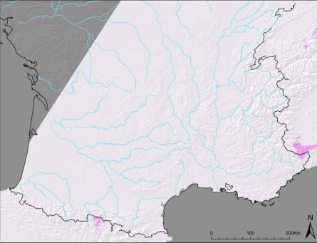
4 Example What is the annual mean of precipitation on the small catchment of Gloriettes? Gloriettes Z 50 = 2230 m Surface = 21 km² Runoff = 1600 mm/year P =??? mm/year 4 Gèdre Z = 1000 m P = 1120 mm/year

5 Question How can we estimate rainfall fields in mountains with point observations often placed in valley? spatial interpolation + elevation extrapolation PhD research (Gottardi et al., 2009) 5
")
6 Outline EDF statistical method for precipitation estimation in mountains First validations Assimilation of snow observations Second (more) validations 6

7 EDF STATISTICAL METHOD FOR PRECIPITATION ESTIMATION IN MOUNTAINS


8 ~1900 raingauges ~220 totalisers Raingauges network PG2000 raingauge Mougin totaliser 8
9 Which period? 40% Example for The Alps 35% 30% Totalisers Raingauges Elevation 25% 20% period 15% 10% 5% 0% Elevation class (m) 9
 WP 3 : Southwest Circulation (8%) WP 4 : South Circulation")
10 Weather patterns : Pressure and rainfalls (1) WP 1 : Atlantic Wave (7%) WP 2 : Steady Oceanic (24%) WP 3 : Southwest Circulation (8%) WP 4 : South Circulation (18%) 10
 WP 7 : Central Depression (3%) WP 8 : Anticyclonic (27%)")
11 Weather patterns : Pressure and rainfalls (2) WP 5 : Northeast Circulation (7%) WP 6 : East Return (6%) WP 7 : Central Depression (3%) WP 8 : Anticyclonic (27%) 11

12 Modelisation of the local orographic effect Citer Barry Mountain weather & Climate, Roger G. Barry (2001) 12
13 Précipitations (mm) (mm) Local linear regression y = 0.08x R 2 = Precipitations of Nov.26,1983 on The Alps Altitude (m)


 14 Norway")
14 Other works USA Precipitation-elevation Regressions on Independent Slopes Model (Daly et al., 1994) Switzerland (Frei and Schär, 1997) 14 Norway (Tveito et al.,2004)
15 15 WP1 average rainfield (Atlantic Wave)

16 16 WP2 average rainfield (Steady Oceanic)

17 17 WP3 average rainfield (Southwest Circulation)

18 18 WP5 average rainfield (Northeast Circulation)
19 19 WP6 average rainfield (East Return)

20 20 WP4 average rainfield (South Circulation)
21 21 WP7 average rainfield (Central Depression)
22 22 WP8 average rainfield (Anticyclonic)


23 23 8 Precipitation guess fields
24 Daily estimation using WP guess fields Obs. of the Day +WPk Guess Field WPk Guess field of the weather pattern But Constrained by observations of the day 24
25 First estimation of daily precipitation
26 FIRST VALIDATIONS
27 Validations 2 validation processes Snow network SWE measurements Local validation Annual Water Balance Runoff measurements Global validation on catchments BUT SWE = Snow rain/melting Snow model Temperature model Runoff = Precip RET stock Evaporation model Temperature model 27

28 28 Validations


29 Temperature Model Rain/Snow discrimination Snowmelt estimation PET estimation Cartography of the daily Tmin and Tmax for the period 29

30 30 EDF Snow network

31 EDF snow network ~ 650 stations : ~ 325 core samplings Monthly gamma-rays attenuation SWE gauges Daily cosmic ray attenuation SWE gauges Daily
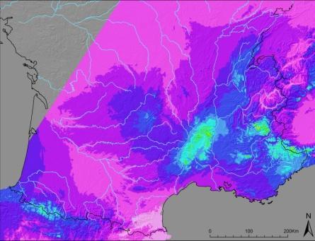
32 Température ( C) Précipitation (mm) Snow Model : a degree-day model 400 SWE gauge of Chardonnet, Modèle winter Simulation oct-91 nov-91 déc-91 janv-92 févr-92 mars-92 avr-92 mai-92 juin P Tmin -20 Tmax oct-91 nov-91 déc-91 janv-92 févr-92 mars-92 avr-92 mai-92 juin
33 Snow Model SWE gauge of Chardonnet, winter Observations Observations Model Modèle Modèle Unbiaised Model !!! /07/ /09/ /11/ /12/ /02/ /04/ /05/ /07/1992
34 Snow validation Precipitation increase to unbias snow simulation
35 Gauged catchments for water balance 175 catchments 64 (Alps) 81 (Massif Central) 30 (Pyrenees) 35
36 Annual Water balances Validation Comparison : Annual deficit D (Annual Precipitation Annual Runoff ) Real Evapotranspiration RET (Turc, 1953 ; Menzel and Lang, 1998 ; Mouelhi, 2003) Hypothesis : D RET 36


37 Water balances 37 Annual Mean deficit for the period


38 ASSIMILATION OF SWE MEASUREMENTS


39 Introduction of snow measurements in weather pattern guess fields Precipitation Raingauges Totalisers SWE Elevation 39
40 Correction of rain gauges measurements as a function of the solid fraction (snow) P * j = C( FS ) j P j C( FS j ) = 1+ 0, 6 FS j 40
41 Replay all the process New weather pattern guess fields with : -SWE measurements, -Corrected raingauges and totalisers measurements, New daily estimations New validations 41
 To reproduce observations : Before Mean multiplicative factor = 1.41 Std Dev. = 0.")
42 SWE Model 153 series are modeled (core sampling, continuous SWE meas.) To reproduce observations : Before Mean multiplicative factor = 1.41 Std Dev. = 0.36 After Mean multiplicative factor = 0.96 Std Dev. =

43 43 New annual water balances


44 44 Annual Mean of precipitation ( )

45 Zoom on the Gloriettes catchment Gèdre : Z = 1000 m P = 1120 mm/year Gloriettes : Z 50 = 2230 m P = 2000 mm/an 45
46 CONCLUSION AND OUTLOOK
47 Conclusion Daily precipitation re-analysis - 1km x 1km grid period - French mountain ranges Consistent with : - Raingauges measurements, - SWE measurements, - Runoff measurements. Synthesis of all the ground information available in mountains. 47
 Better understanding of the snow hydrology Improvement of the operational seasonal forecast")
48 Outlook Real-time maps of precipitation (a prototype is running) SWE maps (Post-Doc work, distributed snow model) Better understanding of the snow hydrology Improvement of the operational seasonal forecast 48
49 49 Thank you for your attention
Méthode SCHADEX : Présentation Application à l Atnasjø (NO), Etude de l utilisation en contexte non-stationnaire
, Etude de l utilisation en contexte non-stationnaire") Workshop "Rencontres Lyon-Grenoble autour des extrêmes" 26 septembre 2012 Méthode SCHADEX : Présentation Application à l Atnasjø (NO), Etude de l utilisation en contexte non-stationnaire Emmanuel PAQUET
Workshop "Rencontres Lyon-Grenoble autour des extrêmes" 26 septembre 2012 Méthode SCHADEX : Présentation Application à l Atnasjø (NO), Etude de l utilisation en contexte non-stationnaire Emmanuel PAQUET
COUPLING A DISTRIBUTED HYDROLOGICAL MODEL TO REGIONAL CLIMATE MODEL OUTPUT: AN EVALUATION OF EXPERIMENTS FOR THE RHINE BASIN IN EUROPE
 P.1 COUPLING A DISTRIBUTED HYDROLOGICAL MODEL TO REGIONAL CLIMATE MODEL OUTPUT: AN EVALUATION OF EXPERIMENTS FOR THE RHINE BASIN IN EUROPE Jan Kleinn*, Christoph Frei, Joachim Gurtz, Pier Luigi Vidale,
R.Garçon, F.Garavaglia, J.Gailhard, E.Paquet, F.Gottardi EDF-DTG
 Homogeneous samples and reliability of probabilistic models : using an atmospheric circulation patterns sampling for a better estimation of extreme rainfall probability R.Garçon, F.Garavaglia, J.Gailhard,
Chiang Rai Province CC Threat overview AAS1109 Mekong ARCC
 Chiang Rai Province CC Threat overview AAS1109 Mekong ARCC This threat overview relies on projections of future climate change in the Mekong Basin for the period 2045-2069 compared to a baseline of 1980-2005.
Hydro-meteorological Analysis of Langtang Khola Catchment, Nepal
 Hydro-meteorological Analysis of Langtang Khola Catchment, Nepal Tirtha R. Adhikari 1, Lochan P. Devkota 1, Suresh.C Pradhan 2, Pradeep K. Mool 3 1 Central Department of Hydrology and Meteorology Tribhuvan
Quenching the Valley s thirst: The connection between Sierra Nevada snowpack & regional water supply
 Quenching the Valley s thirst: The connection between Sierra Nevada snowpack & regional water supply Roger Bales, UC Merced Snow conditions Snow & climate change Research directions Sierra Nevada snow
Changing Hydrology under a Changing Climate for a Coastal Plain Watershed
 Changing Hydrology under a Changing Climate for a Coastal Plain Watershed David Bosch USDA-ARS, Tifton, GA Jeff Arnold ARS Temple, TX and Peter Allen Baylor University, TX SEWRU Objectives 1. Project changes
Seasonal forecasting of climate anomalies for agriculture in Italy: the TEMPIO Project
 Seasonal forecasting of climate anomalies for agriculture in Italy: the TEMPIO Project M. Baldi(*), S. Esposito(**), E. Di Giuseppe (**), M. Pasqui(*), G. Maracchi(*) and D. Vento (**) * CNR IBIMET **
Water information system advances American River basin. Roger Bales, Martha Conklin, Steve Glaser, Bob Rice & collaborators UC: SNRI & CITRIS
 Water information system advances American River basin Roger Bales, Martha Conklin, Steve Glaser, Bob Rice & collaborators UC: SNRI & CITRIS Opportunities Unprecedented level of information from low-cost
Drought Monitoring with Hydrological Modelling
 st Joint EARS/JRC International Drought Workshop, Ljubljana,.-5. September 009 Drought Monitoring with Hydrological Modelling Stefan Niemeyer IES - Institute for Environment and Sustainability Ispra -
Impacts of climate change on flooding in the river Meuse
 Impacts of climate change on flooding in the river Meuse Martijn Booij University of Twente,, The Netherlands m.j.booij booij@utwente.nlnl 2003 in the Meuse basin Model appropriateness Appropriate model
The indicator can be used for awareness raising, evaluation of occurred droughts, forecasting future drought risks and management purposes.
 INDICATOR FACT SHEET SSPI: Standardized SnowPack Index Indicator definition The availability of water in rivers, lakes and ground is mainly related to precipitation. However, in the cold climate when precipitation
1.0 Implications of using daily climatological wind speed prior to 1948
 Supplemental Material 1.0 Implications of using daily climatological wind speed prior to 1948 As detailed in the manuscript, NCEP-NCAR reanalysis wind data were used for the period 1948/01/01-2011/12/31.
Adaptation for global application of calibration and downscaling methods of medium range ensemble weather forecasts
 Adaptation for global application of calibration and downscaling methods of medium range ensemble weather forecasts Nathalie Voisin Hydrology Group Seminar UW 11/18/2009 Objective Develop a medium range
The Climate of Oregon Climate Zone 4 Northern Cascades
 /05 E55 Unbound issue No. 9/ is Does not circulate Special Report 916 May 1993 The Climate of Oregon Climate Zone 4 Property of OREGON STATE UNIVERSITY Library Serials Corvallis, OR 97331-4503 Agricultural
Hydrometeorological forecasts for hydropower generation
 Hydrometeorological forecasts for hydropower generation Serre Poncon lake on Durance river Pierre BERNARD EDF-DTG Water Ressources Departement Email: pierre-2.bernard@edf.fr Hepex Workshop Reading 8-1th
The Importance of Snowmelt Runoff Modeling for Sustainable Development and Disaster Prevention
 The Importance of Snowmelt Runoff Modeling for Sustainable Development and Disaster Prevention Muzafar Malikov Space Research Centre Academy of Sciences Republic of Uzbekistan Water H 2 O Gas - Water Vapor
Inflow Forecasting for Hydro Catchments. Ross Woods and Alistair McKerchar NIWA Christchurch
 Inflow Forecasting for Hydro Catchments Ross Woods and Alistair McKerchar NIWA Christchurch Inflows Water flowing into hydro storages Usually measured by monitoring the levels and outflows from hydro storages
Operational Perspectives on Hydrologic Model Data Assimilation
 Operational Perspectives on Hydrologic Model Data Assimilation Rob Hartman Hydrologist in Charge NOAA / National Weather Service California-Nevada River Forecast Center Sacramento, CA USA Outline Operational
Met Éireann Climatological Note No. 15 Long-term rainfall averages for Ireland,
 Met Éireann Climatological Note No. 15 Long-term rainfall averages for Ireland, 1981-2010 Séamus Walsh Glasnevin Hill, Dublin 9 2016 Disclaimer Although every effort has been made to ensure the accuracy
Climate also has a large influence on how local ecosystems have evolved and how we interact with them.
 The Mississippi River in a Changing Climate By Paul Lehman, P.Eng., General Manager Mississippi Valley Conservation (This article originally appeared in the Mississippi Lakes Association s 212 Mississippi
SNOWMELT RUNOFF ESTIMATION OF A HIMALIYAN WATERSHED THROUGH REMOTE SENSING, GIS AND SIMULATION MODELING
 SNOWMELT RUNOFF ESTIMATION OF A HIMALIYAN WATERSHED THROUGH REMOTE SENSING, GIS AND SIMULATION MODELING A. Alam g, *, A. H. Sheikh g, S. A. Bhat g, A. M.Shah g g Department of Geology & Geophysics University
Enabling Climate Information Services for Europe
 Enabling Climate Information Services for Europe Report DELIVERABLE 6.5 Report on past and future stream flow estimates coupled to dam flow evaluation and hydropower production potential Activity: Activity
Climate Change and Runoff Statistics in the Rhine Basin: A Process Study with a Coupled Climate-Runoff Model
 IACETH Climate Change and Runoff Statistics in the Rhine Basin: A Process Study with a Coupled Climate-Runoff Model Jan KLEINN, Christoph Frei, Joachim Gurtz, Pier Luigi Vidale, and Christoph Schär Institute
A Report on a Statistical Model to Forecast Seasonal Inflows to Cowichan Lake
 A Report on a Statistical Model to Forecast Seasonal Inflows to Cowichan Lake Prepared by: Allan Chapman, MSc, PGeo Hydrologist, Chapman Geoscience Ltd., and Former Head, BC River Forecast Centre Victoria
UPPLEMENT A COMPARISON OF THE EARLY TWENTY-FIRST CENTURY DROUGHT IN THE UNITED STATES TO THE 1930S AND 1950S DROUGHT EPISODES
 UPPLEMENT A COMPARISON OF THE EARLY TWENTY-FIRST CENTURY DROUGHT IN THE UNITED STATES TO THE 1930S AND 1950S DROUGHT EPISODES Richard R. Heim Jr. This document is a supplement to A Comparison of the Early
Water Year Day 2010
 mm mm SCA, % Storage, mm Sto, 1 mm Sat def, 1 mm 25 2 15 1 5 4 3 2 1 2 5 25 2 Saturation deficit depth (water table) Saturation deficit volume Root zone storage Unsaturated soil storage Groundwater storage
HYDROLOGICAL MODELING OF HIGHLY GLACIERIZED RIVER BASINS. Nina Omani, Raghavan Srinivasan, Patricia Smith, Raghupathy Karthikeyan, Gerald North
 HYDROLOGICAL MODELING OF HIGHLY GLACIERIZED RIVER BASINS Nina Omani, Raghavan Srinivasan, Patricia Smith, Raghupathy Karthikeyan, Gerald North Problem statement Glaciers help to keep the earth cool High
What Does It Take to Get Out of Drought?
 What Does It Take to Get Out of Drought? Nolan J. Doesken Colorado Climate Center Colorado State University http://ccc.atmos.colostate.edu Presented at the Insects, Diseases and Drought Workshop, May 19,
Technical Note: Hydrology of the Lake Chilwa wetland, Malawi
 Technical Note: Hydrology of the Lake Chilwa wetland, Malawi Matthew McCartney June 27 Description Lake Chilwa is located in the Southern region of Malawi on the country s eastern boarder with Mozambique
Heihe River Runoff Prediction
 Heihe River Runoff Prediction Principles & Application Dr. Tobias Siegfried, hydrosolutions Ltd., Zurich, Switzerland September 2017 hydrosolutions Overview Background Methods Catchment Characterization
Climate Change and Water Supply Research. Drought Response Workshop October 8, 2013
 Climate Change and Water Supply Research Drought Response Workshop October 8, 2013 DWR Photo Oroville Reservoir, 2009 Talk Overview Expectations History Atmospheric Rivers and Water Supply Current Research
Modeling of peak inflow dates for a snowmelt dominated basin Evan Heisman. CVEN 6833: Advanced Data Analysis Fall 2012 Prof. Balaji Rajagopalan
 Modeling of peak inflow dates for a snowmelt dominated basin Evan Heisman CVEN 6833: Advanced Data Analysis Fall 2012 Prof. Balaji Rajagopalan The Dworshak reservoir, a project operated by the Army Corps
Assessing bias in satellite rainfall products and their impact in water balance closure at the Zambezi headwaters
 Assessing bias in satellite rainfall products and their impact in water balance closure at the Zambezi headwaters Omondi C.K. 1 Rientjes T.H.M. 1, Haile T.A. 2, Gumindoga W. 1,3 (1) Faculty ITC, University
A RADAR-BASED CLIMATOLOGY OF HIGH PRECIPITATION EVENTS IN THE EUROPEAN ALPS:
 2.6 A RADAR-BASED CLIMATOLOGY OF HIGH PRECIPITATION EVENTS IN THE EUROPEAN ALPS: 2000-2007 James V. Rudolph*, K. Friedrich, Department of Atmospheric and Oceanic Sciences, University of Colorado at Boulder,
INVISIBLE WATER COSTS
 Every Drop Every Counts... Drop Counts... INVISIBLE WATER COSTS Corn - 108.1 gallons per pound How much water it takes to produce... Apple - 18.5 gallons to grow Beef - 1,581 gallons per pound Oats - 122.7
Investigations of the precipitation conditions in the central part of the Tianshan mountains
 Hydrology in Mountainous Regions. I - Hydrological Measurements; the Water Cycle (Proceeoings of two Lausanne Symposia, August 990). IAHS Publ. no. 9,990. Investigations of the precipitation conditions
Overview on the modelling setup Seven new features in the modelling framework First results for the Alpine Rhine and Engadin Conclusions and Outlook
 SUB PROJECT: Natural water balance of Switzerland and its most important large river basins Overview on the modelling setup Seven new features in the modelling framework First results for the Alpine Rhine
Outline. Precipitation. How would you describe precipitation patterns in your area? Bottom line: one-page summary
 Outline Precipitation June 13, 2013 Phoenix, AZ Measuring rainfall Patterns of precipitation in time and space Predicting precipitation Patterns related to extreme events (floods & drought) Paleo-climate
CLIMATE CHANGE AND REGIONAL HYDROLOGY ACROSS THE NORTHEAST US: Evidence of Changes, Model Projections, and Remote Sensing Approaches
 CLIMATE CHANGE AND REGIONAL HYDROLOGY ACROSS THE NORTHEAST US: Evidence of Changes, Model Projections, and Remote Sensing Approaches Michael A. Rawlins Dept of Geosciences University of Massachusetts OUTLINE
Disentangling Impacts of Climate & Land Use Changes on the Quantity & Quality of River Flows in Southern Ontario
 Disentangling Impacts of Climate & Land Use Changes on the Quantity & Quality of River Flows in Southern Ontario by Trevor Dickinson & Ramesh Rudra, Water Resources Engineering University of Guelph Acknowledgements
Presentation Overview. Southwestern Climate: Past, present and future. Global Energy Balance. What is climate?
 Southwestern Climate: Past, present and future Mike Crimmins Climate Science Extension Specialist Dept. of Soil, Water, & Env. Science & Arizona Cooperative Extension The University of Arizona Presentation
Southern Sierra Critical Zone Observatory (CZO): hydrochemical characteristics, science & measurement strategy
: hydrochemical characteristics, science & measurement strategy") Southern Sierra Critical Zone Observatory (CZO): hydrochemical characteristics, science & measurement strategy R. Bales, C. Hunsaker, M. Conklin, J. Kirchner, B. Boyer, P. Kirchner underlying hypothesis:
Southern Sierra Critical Zone Observatory (CZO): hydrochemical characteristics, science & measurement strategy R. Bales, C. Hunsaker, M. Conklin, J. Kirchner, B. Boyer, P. Kirchner underlying hypothesis:
Climatic Change Implications for Hydrologic Systems in the Sierra Nevada
 Climatic Change Implications for Hydrologic Systems in the Sierra Nevada Part Two: The HSPF Model: Basis For Watershed Yield Calculator Part two presents an an overview of why the hydrologic yield calculator
CHAPTER 1 INTRODUCTION
 CHAPTER 1 INTRODUCTION Mean annual precipitation (MAP) is perhaps the most widely used variable in hydrological design, water resources planning and agrohydrology. In the past two decades one of the basic
IMPACT OF LOW FLOWS ON THE ENERGY SECTOR
 IMPACT OF LOW FLOWS ON THE ENERGY SECTOR PUYGRENIER Damien ANTHEAUME Mélanie CHR Symposium Low Flows in the Rhine Catchment September 21 st 2017 OUTLINE GENERAL CONTEXT MANAGEMENT OF LOW FLOWS AT EDF CASE
Novel Snotel Data Uses: Detecting Change in Snowpack Development Controls, and Remote Basin Snow Depth Modeling
 Novel Snotel Data Uses: Detecting Change in Snowpack Development Controls, and Remote Basin Snow Depth Modeling OVERVIEW Mark Losleben and Tyler Erickson INSTAAR, University of Colorado Mountain Research
Temporal variability in the isotopic composition of meteoric water in Christchurch, New Zealand; Can we create reliable isoscapes?
 1 2 3 4 5 6 7 8 9 10 11 12 13 14 15 16 17 18 19 20 21 22 23 24 25 26 27 28 29 30 31 Temporal variability in the isotopic composition of meteoric water in Christchurch, New Zealand; Can we create reliable
Influence of rainfall space-time variability over the Ouémé basin in Benin
 102 Remote Sensing and GIS for Hydrology and Water Resources (IAHS Publ. 368, 2015) (Proceedings RSHS14 and ICGRHWE14, Guangzhou, China, August 2014). Influence of rainfall space-time variability over
Hydrologic Overview & Quantities
 Hydrologic Overview & Quantities It is important to understand the big picture when attempting to forecast. This includes the interactive components and hydrologic quantities. Hydrologic Cycle The complexity
Souris River Basin Spring Runoff Outlook As of March 15, 2018
 Souris River Basin Spring Runoff Outlook As of March 15, 2018 Prepared by: Flow Forecasting & Operations Planning Water Security Agency Basin Conditions Summer rainfall in 2017 in the Saskatchewan portion
Prediction of Snow Water Equivalent in the Snake River Basin
 Hobbs et al. Seasonal Forecasting 1 Jon Hobbs Steve Guimond Nate Snook Meteorology 455 Seasonal Forecasting Prediction of Snow Water Equivalent in the Snake River Basin Abstract Mountainous regions of
Let s Talk Climate! Nolan Doesken Colorado Climate Center Colorado State University. Yampatika Seminar February 16, 2011 Steamboat Springs, Colorado
 Let s Talk Climate! Nolan Doesken Colorado Climate Center Colorado State University Yampatika Seminar February 16, 2011 Steamboat Springs, Colorado First -- A short background In 1973 the federal government
Seasonal Forecasts of River Flow in France
 Seasonal Forecasts of River Flow in France Laurent Dubus 1, Saïd Qasmi 1, Joël Gailhard 2, Amélie Laugel 1 1 EDF R&D (Research & Development Division) 2 EDF DTG (hydro-meteorological forecasting division)
Supplementary Materials for
 advances.sciencemag.org/cgi/content/full/3/12/e1701169/dc1 Supplementary Materials for Abrupt shift in the observed runoff from the southwestern Greenland ice sheet Andreas P. Ahlstrøm, Dorthe Petersen,
Missouri River Basin Water Management Monthly Update
 Missouri River Basin Water Management Monthly Update Participating Agencies 255 255 255 237 237 237 0 0 0 217 217 217 163 163 163 200 200 200 131 132 122 239 65 53 80 119 27 National Oceanic and Atmospheric
Towards a probabilistic hydrological forecasting and data assimilation system. Henrik Madsen DHI, Denmark
 Towards a probabilistic hydrological forecasting and data assimilation system Henrik Madsen DHI, Denmark Outline Hydrological forecasting Data assimilation framework Data assimilation experiments Concluding
2003 Moisture Outlook
 2003 Moisture Outlook Nolan Doesken and Roger Pielke, Sr. Colorado Climate Center Prepared by Tara Green and Odie Bliss http://climate.atmos.colostate.edu Through 1999 Through 1999 Fort Collins Total Water
Souris River Basin Spring Runoff Outlook As of March 1, 2019
 Souris River Basin Spring Runoff Outlook As of March 1, 2019 Prepared by: Flow Forecasting & Operations Planning Water Security Agency Basin Conditions Summer rainfall in 2018 over the Saskatchewan portion
Westmap: The Western Climate Mapping Initiative An Update
 Westmap: The Western Climate Mapping Initiative An Update Andrew Comrie 1, Kelly Redmond 2, Mary Glueck 1, Hauss Reinbold 3, Chris Daly 4 1 University of Arizona, 2 DRI / Western Regional Climate Center
Gridded observation data for Climate Services
 Gridded observation data for Climate Services Ole Einar Tveito, Inger Hanssen Bauer, Eirik J. Førland and Cristian Lussana Norwegian Meteorological Institute Norwegian annual temperatures Norwegian annual
INTERPOLATING SURFACE AIR TEMPERATURE FOR USE IN SEMI-DISTRIBUTED SNOWMELT RUNOFF MODELS
 INTERPOLATING SURFACE AIR TEMPERATURE FOR USE IN SEMI-DISTRIBUTED SNOWMELT RUNOFF MODELS Best Poster Award, WSC 2005 - T. R. Blandford, B. J. Harshburger, K. S. Humes, B. C. Moore, V. P. Walden 1 ABSTRACT
Monthly Long Range Weather Commentary Issued: APRIL 25, 2016 Steven A. Root, CCM, Chief Analytics Officer, Sr. VP, sales
 Monthly Long Range Weather Commentary Issued: APRIL 25, 2016 Steven A. Root, CCM, Chief Analytics Officer, Sr. VP, sales sroot@weatherbank.com MARCH 2016 Climate Highlights The Month in Review The March
The Climate of Oregon Climate Zone 3 Southwest Interior
 .k) 105 Unbound issue " " 1 4oes not circulate C4P. Special Report 915 May 1993 The Climate of Oregon Climate Zone 3 Southwest Interior Property of OREGON STATE UNIVERSITY Library Serials Corvallis, OR
Technical Note: Hydrology of the Lukanga Swamp, Zambia
 Technical Note: Hydrology of the Lukanga Swamp, Zambia Matthew McCartney July 7 Description The Lukanga swamp is located approximately 5km west of the city of Kabwe, in the Central province of Zambia,
Model resolution impact on Precipitation: Comparison to SNOTEL observations
 Model resolution impact on Precipitation: Comparison to SNOTEL observations 5/7/2012 40 proj. updates Sensitivity to model grid resolution: Precipitation from the 8-year Current Climate Simulation Percent
Missouri River Basin Water Management Monthly Update
 Missouri River Basin Water Management Monthly Update Participating Agencies 255 255 255 237 237 237 0 0 0 217 217 217 163 163 163 200 200 200 131 132 122 239 65 53 80 119 27 National Oceanic and Atmospheric
Regional Climate Change: Current Impacts and Perspectives Greater Lake Nipissing Stewardship Council Annual Meeting Wednesday April 16, 2014
 Regional Climate Change: Current Impacts and Perspectives Greater Lake Nipissing Stewardship Council Annual Meeting Wednesday April 16, 2014 Speaker: Peter Bullock, Stantec Consulting Information Source:
USA National Weather Service Community Hydrologic Prediction System
 USA National Weather Service Community Hydrologic Prediction System Rob Hartman Hydrologist in Charge NOAA / National Weather Service California-Nevada River Forecast Center Sacramento, CA Background Outline
Robert Shedd Northeast River Forecast Center National Weather Service Taunton, Massachusetts, USA
 Robert Shedd Northeast River Forecast Center National Weather Service Taunton, Massachusetts, USA Outline River Forecast Centers FEWS Implementation Status Forcing Data Ensemble Forecasting The Northeast
Science Standard 1: Students analyze monthly precipitation and temperature records, displayed in bar charts, collected in metric units (mm).
.") Title: Precipitation Patterns across the Globe NSF GK-12 Fellow: Terry Legg Type of Lesson: STEM Grade Level(s): 4 th - 7 th grade This activity can be tailored to older, more advanced students by having
Title: Precipitation Patterns across the Globe NSF GK-12 Fellow: Terry Legg Type of Lesson: STEM Grade Level(s): 4 th - 7 th grade This activity can be tailored to older, more advanced students by having
Impact of climate change on freshwater resources in the Changjiang river basin
 Impact of climate change on freshwater resources in the Changjiang river basin Wenfa Yang, Yan Huang Bureau of Hydrology, Changjiang Water Resources Commission, MWR, China April,2009 Objective To identify
EFFICIENCY OF THE INTEGRATED RESERVOIR OPERATION FOR FLOOD CONTROL IN THE UPPER TONE RIVER OF JAPAN CONSIDERING SPATIAL DISTRIBUTION OF RAINFALL
 EFFICIENCY OF THE INTEGRATED RESERVOIR OPERATION FOR FLOOD CONTROL IN THE UPPER TONE RIVER OF JAPAN CONSIDERING SPATIAL DISTRIBUTION OF RAINFALL Dawen YANG, Eik Chay LOW and Toshio KOIKE Department of
NIDIS Intermountain West Drought Early Warning System May 23, 2017
 NIDIS Drought and Water Assessment NIDIS Intermountain West Drought Early Warning System May 23, 2017 Precipitation The images above use daily precipitation statistics from NWS COOP, CoCoRaHS, and CoAgMet
AN ASSESSMENT OF THE RELATIONSHIP BETWEEN RAINFALL AND LAKE VICTORIA LEVELS IN UGANDA
 AN ASSESSMENT OF THE RELATIONSHIP BETWEEN RAINFALL AND LAKE VICTORIA LEVELS IN UGANDA BY CATHERINE MULINDE BA (Environmental Management), PGD (Meteorology) Teaching Assistant Department of Geography, Meteorology
Estimating the Spatial Variability of Weather in Mountain Environments
 Estimating the Spatial Variability of Weather in Mountain Environments C. Baigorria 1, W. Bowen 2, and j. Stoorvogel Models of crop and soil systems are useful tools for understanding the complexity of
Development of Pakistan s New Area Weighted Rainfall Using Thiessen Polygon Method
 Pakistan Journal of Meteorology Vol. 9, Issue 17: July 2012 Technical Note Development of Pakistan s New Area Weighted Rainfall Using Thiessen Polygon Method Faisal, N. 1, 2, A. Gaffar 2 ABSTRACT In this
2003 Water Year Wrap-Up and Look Ahead
 2003 Water Year Wrap-Up and Look Ahead Nolan Doesken Colorado Climate Center Prepared by Odie Bliss http://ccc.atmos.colostate.edu Colorado Average Annual Precipitation Map South Platte Average Precipitation
RELATIVE IMPORTANCE OF GLACIER CONTRIBUTIONS TO STREAMFLOW IN A CHANGING CLIMATE
 Proceedings of the Second IASTED International Conference WATER RESOURCE MANAGEMENT August 20-22, 2007, Honolulu, Hawaii, USA ISGN Hardcopy: 978-0-88986-679-9 CD: 978-0-88-986-680-5 RELATIVE IMPORTANCE
Flood Inundation Mapping under different climate change scenarios in the upper Indus River Basin, Pakistan
 Flood Inundation Mapping under different climate change scenarios in the upper Indus River Basin, Pakistan Sohaib Baig (doctoral student) 16 November 2017 Disaster Prevention Research Institute 1 Kyoto
4. THE HBV MODEL APPLICATION TO THE KASARI CATCHMENT
 Application of HBV model to the Kasari River, 1994 Page 1 of 6 Application of the HBV model to the Kasari river for flow modulation of catchments characterised by specific underlying features by R. Vedom,
Drought in Southeast Colorado
 Drought in Southeast Colorado Nolan Doesken and Roger Pielke, Sr. Colorado Climate Center Prepared by Tara Green and Odie Bliss http://climate.atmos.colostate.edu 1 Historical Perspective on Drought Tourism
Drought and Future Water for Southern New Mexico
 Drought and Future Water for Southern New Mexico David S. Gutzler University of New Mexico gutzler@unm.edu * The big drought of 2018 * Longer term challenges for water supply * Forecasting streamflow Elephant
Key Finding: Long Term Trend During 2014: Rain in Indian Tradition Measuring Rain
 Chapter 34 RAINFALL Key Finding: Long Term Trend Despite of theories suggesting increase in rainfall in Asian Region due to global warming, no significant trend has been observed at all India level (confirmed
Winter Climate Forecast
 Winter 2018-2019 Climate Forecast 26 th Winter Weather Meeting, OMSI and Oregon AMS, Portland Kyle Dittmer Hydrologist-Meteorologist Columbia River Inter-Tribal Fish Commission Portland, Oregon Professor
Minnesota s Climatic Conditions, Outlook, and Impacts on Agriculture. Today. 1. The weather and climate of 2017 to date
 Minnesota s Climatic Conditions, Outlook, and Impacts on Agriculture Kenny Blumenfeld, State Climatology Office Crop Insurance Conference, Sep 13, 2017 Today 1. The weather and climate of 2017 to date
TABLE OF CONTENTS. 3.1 Synoptic Patterns Precipitation and Topography Precipitation Regionalization... 11
 TABLE OF CONTENTS ABSTRACT... iii 1 INTRODUCTION... 1 2 DATA SOURCES AND METHODS... 2 2.1 Data Sources... 2 2.2 Frequency Analysis... 2 2.2.1 Precipitation... 2 2.2.2 Streamflow... 2 2.3 Calculation of
Hydrologicalcycle in the mountains Part II Somemodellingissues
 Hydrologicalcycle in the mountains Part II Somemodellingissues Isabella Zin isabella.zin@grenoble-inp.fr Contents Modelling the water cycle in mountain catchments : Scaling and uncertainty issues Case
Winter Climate Forecast
 Winter 2017-2018 Climate Forecast 25 th Winter Weather Meeting, OMSI and Oregon AMS, Portland Kyle Dittmer Hydrologist-Meteorologist Columbia River Inter-Tribal Fish Commission Portland, Oregon Professor
Missouri River Basin Water Management Monthly Update
 Missouri River Basin Water Management Monthly Update Participating Agencies 255 255 255 237 237 237 0 0 0 217 217 217 163 163 163 200 200 200 131 132 122 239 65 53 80 119 27 National Oceanic and Atmospheric
The elevations on the interior plateau generally vary between 300 and 650 meters with
 11 2. HYDROLOGICAL SETTING 2.1 Physical Features and Relief Labrador is bounded in the east by the Labrador Sea (Atlantic Ocean), in the west by the watershed divide, and in the south, for the most part,
The Climate of Oregon Climate Zone 5 High Plateau
 105 E55 Unbound issue i". 9 13oes not circulate CZe Special Report 917 May 1993 The Climate of Oregon Climate Zone 5 Property of OREGON STATE UNIVERSITY Library Serials Corvallis, OR 97331-4503 Agricultural
Monthly Long Range Weather Commentary Issued: SEPTEMBER 19, 2016 Steven A. Root, CCM, Chief Analytics Officer, Sr. VP,
 Monthly Long Range Weather Commentary Issued: SEPTEMBER 19, 2016 Steven A. Root, CCM, Chief Analytics Officer, Sr. VP, sroot@weatherbank.com SEPTEMBER 2016 Climate Highlights The Month in Review The contiguous
VOLUME IV. Feasibility Study for the Madian Hydropower Project HYDRO - METEOROLOGICAL DATA BASE. Headrace Tunnel. Bahrain. Part 1 of 3.
 for the Weir Bahrain Headrace Tunnel Madian Powerhouse Madain Town VOLUME IV HYDRO - METEOROLOGICAL DATA BASE Part 1 of 3 Weir Axis 7166P02 February 2009 Table of Contents VOLUME I: EXECUTIVE SUMMARY VOLUME
APPLICATIONS OF DOWNSCALING: HYDROLOGY AND WATER RESOURCES EXAMPLES
 APPLICATIONS OF DOWNSCALING: HYDROLOGY AND WATER RESOURCES EXAMPLES Dennis P. Lettenmaier Department of Civil and Environmental Engineering For presentation at Workshop on Regional Climate Research NCAR
Missouri River Flood Task Force River Management Working Group Improving Accuracy of Runoff Forecasts
 Missouri River Flood Task Force River Management Working Group Improving Accuracy of Runoff Forecasts Kevin Grode, P.E. Reservoir Regulation Team Lead Missouri River Basin Water Management Northwestern
Sierra Weather and Climate Update
 Sierra Weather and Climate Update 2014-15 Kelly Redmond Western Regional Climate Center Desert Research Institute Reno Nevada Yosemite Hydroclimate Workshop Yosemite Valley, 2015 October 8-9 Percent of
CoCoRaHS Monitoring Colorado s s Water Resources through Community Collaborations
 CoCoRaHS Monitoring Colorado s s Water Resources through Community Collaborations Nolan Doesken Colorado Climate Center Atmospheric Science Department Colorado State University Presented at Sustaining
Application of Satellite Data for Flood Forecasting and Early Warning in the Mekong River Basin in South-east Asia
 MEKONG RIVER COMMISSION Vientiane, Lao PDR Application of Satellite Data for Flood Forecasting and Early Warning in the Mekong River Basin in South-east Asia 4 th World Water Forum March 2006 Mexico City,
Evaluating extreme flood characteristics of small mountainous basins of the Black Sea coastal area, Northern Caucasus
 Proc. IAHS, 7, 161 165, 215 proc-iahs.net/7/161/215/ doi:1.5194/piahs-7-161-215 Author(s) 215. CC Attribution. License. Evaluating extreme flood characteristics of small mountainous basins of the Black