Sediment Characterization and Metal Bioavailability within a Range Complex, MCRD Parris Island, South Carolina. 6 May 2009
|
|
|
- Oswin Bruce
- 6 years ago
- Views:
Transcription


1 Sediment Characterization and Metal Bioavailability within a Range Complex, MCRD Parris Island, South Carolina 1 6 May 2009
2 Contributing Authors Daniel Tomczak, CH2M HILL, Raleigh, North Carolina Kristen Duda, CH2M HILL, Knoxville, Tennessee Russell Short, CH2M HILL, Atlanta, Georgia Patty White, CH2M HILL, Boston, Massachusetts Tim Harrington, MCRD Parris Island, South Carolina 2
3 Additional Support University of South Carolina at Beaufort Georgia Institute of Technology, Savannah Marine Corps Recruit Depot Parris Island, South Carolina NAVFAC Southeast, Jacksonville, Florida Jon Weier, CH2M HILL, Atlanta, Georgia 3


4 4 Marine Corps Recruit Depot Parris Island South Carolina, USA
, is located at the confluence of the Broad and Beaufort Rivers in coastal South Carolina Military training activities began in 1918 when a rifle range was established in the vicinity of the")
5 MCRD Parris Island Description and History 5 MCRD Parris Island, which covers over 8,000 acres (32.5 km 2 ), is located at the confluence of the Broad and Beaufort Rivers in coastal South Carolina Military training activities began in 1918 when a rifle range was established in the vicinity of the Khe Sahn Range. Today, the Weapons and Field Training Battallion (WFTBN) Complex includes a multipurpose infantry weapon range, four known distance ranges, and two pistol ranges. Typical expended rounds present at small arms ranges include pistol (9 mm), M16 (5.56 mm), and M60 (7.62 mm) with metal composition of copper, lead, zinc, and antimony Range impact area, consisting of over 1,500 acres of tidal creeks and marshlands, is inundated by seawater at high tides twice each day with tidal ranges of approximately 7 feet

6 6 WFTBN Complex
7 CH2M HILL s Primary Tasks for the Sediment Investigation Assist the Marine Corps by evaluating the potential for munitions constituents (MC) to migrate off operational ranges and identifying potential impacts to human health and the environment (REVA 2006) Collaborate with staff from Georgia Tech-Savannah and the University of South Carolina-Beaufort on the field activities and sediment sampling Evaluate metal loading and bioavailability within the sediments of the range impact area, perform ecological and human health screening evaluations, and evaluate potential for sediment transport Develop a range sustainability action plan 7

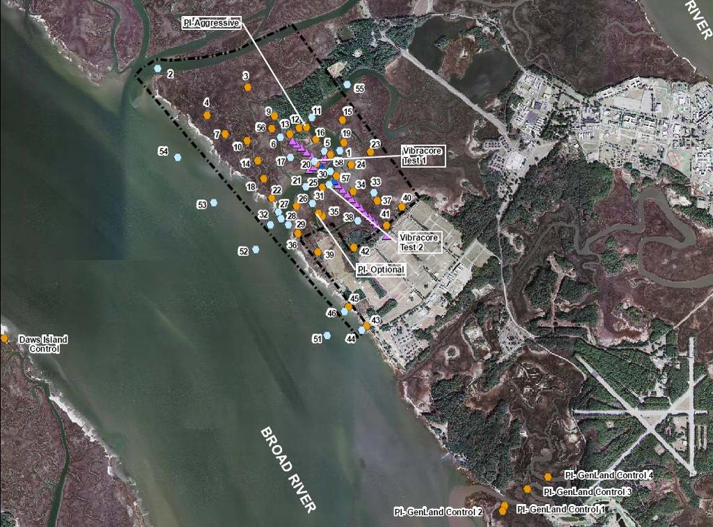
8 WFTBN Complex Sediment Sampling Using both push cores and vibracore sampling techniques, collected sediment samples from 50 locations within and outside the WFTBN impact area. In addition, collected background samples on Daws Island and the General s Landing area. Points selected based on results of a conceptual site model developed using data on the historic munitions deposition and on site observations of buried projectiles Samples were analyzed for: SEM/AVS: simultaneously extracted metals and acid volatile sulfides ratio Total Organic Carbon, Bulk Density, and Grain Size Bulk Metals (Copper, Lead, Zinc, Iron, Manganese, and Antimony) using Portable XRF (provided by USCB) 8
9 9

10 10 Sample Location Access within the Marsh

11 11 Sediment Sampling Push Cores

12 12 Sediment Sampling Push Cores


13 13 Sediment Sampling with a Vibracore


14 14 Sediment Sampling with a Vibracore
 in one sediment sample Metal concentrations were higher in the intertidal marsh locations than within the tidal creek channels Metal")
15 General Trends in Metals Concentrations Copper concentrations in sediment at the WTFBN were the most frequently elevated relative to background, followed by lead and then zinc Antimony was only reported above the instrument detection limit (~12 mg/kg) in one sediment sample Metal concentrations were higher in the intertidal marsh locations than within the tidal creek channels Metal concentrations generally decrease with sediment depth Most of the elevated metal concentrations in sediment were identified down from the firing directions of three distance ranges as well as the pistol ranges 15

16 Geochemical Normalization of Metal Enriched Samples Used to differentiate between potential site-related releases of metals and background sources of metals Aluminum, iron, TOC, and grain size can be used as geochemical normalizers Cross plots were generated with the data for lead, zinc, and copper by using iron as the geochemical normalizer and also included background samples from Daws Island and General s Landing control points Samples that plot above a background relationship have an additional source contribution not present in background samples 16

17 17 Copper vs Iron Cross Plot

18 18 Lead vs Iron Cross Plot

19 19 Zinc vs Iron Cross Plot

20 Sediment Physical Characteristics Results Total Organic Carbon Generally lower in the coarse quartz (sand) grain deposits (<30,600 mg/kg) as compared with the finer marsh deposits (<53,300 mg/kg) More organic materials in the higher marsh areas due to the decomposition of the marsh grasses Bulk Density Creek channel deposits ranged from 0.51 to 1.75 g/cm 3, while the marsh deposits ranged from 0.38 to 1.72 g/cm 3 Slight increase in values with depth, possibly due to consolidation 20
21 SEM/AVS Ratio Empirical method used to determine if sediment deposits have sufficient sulfides to bind with and immobilize divalent metals including cadmium, copper, lead, nickel, silver, and zinc Volatile sulfides generally consist of iron sulfide minerals and dissolved sulfide species chemically reactive to metals When AVS > Metals, the sulfide binds with selected cationic metals to form insoluble sulfide complexes with minimal biological availability Samples analyzed by a laboratory using the method Determination of Acid Volatile Sulfide and Selected Simultaneously Extracted Metals in Sediment (EPA 1991) 21

22 22
23 SEM/AVS Ratio Results Of the 50 sampling locations, only 6 locations reported the SEM/AVS ratio greater than 1, indicating the metals are bioavailable in isolated locations Elevated SEM/AVS ratios were only reported in the deposit depths of 0 to 6 inches and 6 to 12 inches below surface Elevated SEM/AVS ratios at locations within the intertidal marsh (BS-12, BS-13, and BS-24) and tidal beach adjacent to Broad River (BS-43) correlate with elevated detections of copper, zinc, and lead Only one location (BS-30) within the tidal creek channel (Edding Creek) reported an elevated SEM/AVS ratio 23
 and therefore contribute to drive the site-wide risk Based upon field observations,")
24 Preliminary Risk Screening and Sediment Transport Human health screening indicates potential risks from direct contact with sediment under recreational use scenario are minimal Ecological risk screening indicates that lead and/or copper are most elevated at 3 sample locations (BS-12, BS-13, and BS-43) and therefore contribute to drive the site-wide risk Based upon field observations, significant resuspension and off-site transport of MC from the interior of the intertidal marsh is unlikely Metals that are adsorbed to the fine-grained sediments within or adjacent to the tidal channels could be transported off-site due to erosion and transport of tidal currents or by wave action along the Broad River shoreline 24
 Metals are")
25 Summary of Sediment Characterization Elevated metal concentrations generally occur in the intertidal marsh sediments rather than in the tidal channels, as well as at select locations along the Broad River shoreline Copper is elevated above background levels more frequently than lead, followed by zinc (copper concentrations are higher in jackets of the munition projectiles) Metals are bioavailable in select and isolated locations within the WFTBN in the depth range of 0 to 12 inches below surface Impacts to the WFTBN by the range activities appear to be localized and pose minimal risk to human and ecological receptors Off-site transport of sediment-associated metals appears to be limited to areas within or adjacent to the tidal channels or along the Broad River shoreline Results are being used to develop range sustainability action plan 25
 760-1776 daniel.tomczak@ch2m.")
26 Questions? CH2M HILL Project Manager Kristen Duda (865) CH2M HILL Task Manager Dan Tomczak (919) MCRD Parris Island Point of Contact Tim Harrington (843)
Technical Memorandum No Sediment Model
 Pajaro River Watershed Study in association with Technical Memorandum No. 1.2.9 Sediment Model Task: Development of Sediment Model To: PRWFPA Staff Working Group Prepared by: Gregory Morris and Elsie Parrilla
3. MARINE HABITAT RESTORATION
 Feasibility Study for Restoration of Titlow Lagoon Fish Passage South Puget Sound Salmon Enhancement Group 3. MARINE HABITAT RESTORATION Marine habitat restoration at Titlow Park could include restoration
Island Design. UMRS EMP Regional Workshop. Presentation for the
 Island Design Presentation for the UMRS EMP Regional Workshop by Jon Hendrickson Hydraulic Engineer Regional Technical Specialist, Water Quality and Habitat Restoration August 17 19, 2005 Project Delivery
ENGINEERING WITH NATURE: NEARSHORE BERM PLACEMENTS AT FORT MYERS BEACH AND PERDIDO KEY, FLORIDA, USA
 1 ENGINEERING WITH NATURE: NEARSHORE BERM PLACEMENTS AT FORT MYERS BEACH AND PERDIDO KEY, FLORIDA, USA KATHERINE E. BRUTSCHÉ 1, PING WANG 2, JULIE D. ROSATI 1, CHERYL E. POLLOCK 1 1. U.S. Army Engineer
A bench-scale process to remove Pb from firing range soils
 A bench-scale process to remove Pb from firing range soils Dermatas D., Dadachov M., Dutko P., Menounou N., Cefaloni J., Arienti P., Tsaneva V. and Shen G. W. M. Keck Geoenvironmental Laboratory Center
PRESENTATION TITLE. Regional Sediment Management Application of a Coastal Model at the St. Johns River Entrance BUILDING STRONG
 PRESENTATION TITLE Regional Sediment Management Application of a Coastal Model at the St. Johns River Entrance Steven Bratos Senior Coastal Engineer U.S. Army Corps of Engineers Jacksonville District February
ENGINEERING APPROACHES TO SHORELINE PLACEMENT FROM COAST TO COAST
 ENGINEERING APPROACHES TO SHORELINE PLACEMENT FROM COAST TO COAST 237 237 237 217 217 217 200 200 200 0 0 0 163 163 163 131 132 122 80 119 27 252 174.59 83 36 118 110 135 120 112 92 56 62 102 130 Comparing
L.O: SLOWING STREAMS DEPOSIT (SORT) SEDIMENT HORIZONTALLY BY SIZE.
 SEDIMENT HORIZONTALLY BY SIZE.") L.O: SLOWING STREAMS DEPOSIT (SORT) SEDIMENT HORIZONTALLY BY SIZE. 1. Base your answer to the following question on the profile shown below, which shows the pattern of horizontal sorting produced at a
L.O: SLOWING STREAMS DEPOSIT (SORT) SEDIMENT HORIZONTALLY BY SIZE. 1. Base your answer to the following question on the profile shown below, which shows the pattern of horizontal sorting produced at a
PTM: A Lagrangian Particle Tracking Model. Joseph Gailani
 PTM: A Lagrangian Particle Tracking Model Joseph Gailani Joe.Z.Gailani@usace.army.mil OUTLINE Motivation for sediment/constituent modeling system Objectives of modeling system Description of PTM PTM Example
Carbon Sequestration Potential from Coastal Wetlands Restoration Sites
 Carbon Sequestration Potential from Coastal Wetlands Restoration Sites Insert then choose Picture select your picture. Right click your picture and Send to back. Paul Krause, Alyssa Beach Emily Cooper,
The rate and fate of coastal carbon burial
 The rate and fate of coastal carbon burial Matthew L. Kirwan, Virginia Institute of Marine Science Main Points Marsh size Marsh accretion 1. SLR drives wetland carbon burial in vertical and lateral dimensions
Design of Levee Breaches in Sheltered Water for Flood Risk Reduction & Marsh Restoration ASFMP; June 5, 2014 Presented By:
 Design of Levee Breaches in Sheltered Water for Flood Risk Reduction & Marsh Restoration ASFMP; June 5, 2014 Presented By: Rohin Saleh Alameda County Flood Control District Matt Powers, P.E. GEI Consultants
Regional-scale understanding of the geologic character and sand resources of the Atlantic inner continental shelf, Maine to Virginia
 Regional-scale understanding of the geologic character and sand resources of the Atlantic inner continental shelf, Maine to Virginia Workshop on Dredging, Beach Nourishment and Bird Conservation Atlantic
Source Control Early Action Focused Feasibility Study
 Source Control Early Action Focused Feasibility Study Empirical Mass Balance Model Results or the Lower Passaic River Edward A. Garvey, PhD, PG Malcolm Pirnie, Inc. Remedial Options Workgroup Meeting June
Annual transport rates at two locations on the fore-slope.
 Sediment Transport by Currents Fore-slope Sediment transport rates and sediment concentrations were computed from the hydrodynamic model runs as well as from direct measurements of current velocities at
Highland Lake Bathymetric Survey
 Highland Lake Bathymetric Survey Final Report, Prepared For: The Town of Highland Lake 612 Lakeshore Drive Oneonta, AL 35121 Prepared By: Tetra Tech 2110 Powers Ferry Road SE Suite 202 Atlanta, GA 30339
The physical breakdown and chemical alteration of rocks and minerals at or near Earth s surface.
 The physical breakdown and chemical alteration of rocks and minerals at or near Earth s surface. The material that is chemically and mechanically weathered to yield sediment and soil. Regolith consisting
2 Georgia: Its Heritage and Its Promise
 TERMS region, erosion, fault, elevation, Fall Line, aquifer, marsh, climate, weather, precipitation, drought, tornado, hurricane, wetland, estuary, barrier island, swamp PLACES Appalachian Mountains, Appalachian
Subcommittee on Sedimentation Draft Sediment Analysis Guidelines for Dam Removal
 Subcommittee on Sedimentation Draft Sediment Analysis Guidelines for Dam Removal August 4, 2011 Jennifer Bountry, M.S., P.E. Tim Randle, M.S., P.E., D.WRE. Blair Greimann, Ph.D., P.E. Sedimentation and
Lab 7: Sedimentary Structures
 Name: Lab 7: Sedimentary Structures Sedimentary rocks account for a negligibly small fraction of Earth s mass, yet they are commonly encountered because the processes that form them are ubiquitous in the
Wetland Sediment Dynamics at Crissy Field Marsh Annual Report
 Wetland Sediment Dynamics at Crissy Field Marsh 27 Annual Report John Callaway Department of Environmental Science University of San Francisco 217 Fulton St. San Francisco, CA 94117 (415) 422-572 callaway@usfca.edu
The Coast: Beaches and Shoreline Processes
 1 2 3 4 5 6 7 8 9 The Coast: es and Shoreline Processes Trujillo & Thurman, Chapter 10 Oceanography 101 Chapter Objectives Recognize the various landforms characteristic of beaches and coastal regions.
Old Stone Sewer Main Street
 Bangor Landing Bangor, Maine Case Study-Sediment Sediment Investigation Maine Department of Environmental Protection City of Bangor, with RMT, Inc. Site Location and Local Site Features 1 Bangor Landing
The Coast: Beaches and Shoreline Processes Trujillo & Thurman, Chapter 10
 The Coast: es and Shoreline Processes Trujillo & Thurman, Chapter 10 Oceanography 101 Chapter Objectives Recognize the various landforms characteristic of beaches and coastal regions. Identify seasonal
Introduction Fluvial Processes in Small Southeastern Watersheds
 Introduction Fluvial Processes in Small Southeastern Watersheds L. Allan James Scott A. Lecce Lisa Davis Southeastern Geographer, Volume 50, Number 4, Winter 2010, pp. 393-396 (Article) Published by The
2.2.7 Backbarrier flats
 FIGURE 24. VERTICAL PHOTOGRAPH SHOWING THE DEVELOPMENT OF SMALL PARABOLIC DUNES FROM BLOWOUTS IN A LARGE RELICT FOREDUNE NORTHWEST OF HUNTER'S CREEK. PHOTOGRAPH COURTESY OF CAR'T'ER HOLT HARVEY FORESTS
A BEACH IS A BEACH. Or Is It? Hawaii. St. Croix, US Virgin Islands
 A BEACH IS A BEACH Or Is It? Pt. Reyes, California Western Florida Hawaii AGI What is a beach? Eastern Maine A beach is a strip of shoreline washed by waves and tides. Crane Key, Florida Bay St. Croix,
What is weathering and how does it change Earth s surface? Answer the question using
 7 th Grade Lesson What is weathering and how does it change Earth s surface? Answer the question using the sentence frame. You have 4 minutes. Weathering is. This changes the Earth s surface because. 1
Weathering of Rocks. Weathering - Breakdown of rocks into pieces (sediment) 2 main types of weathering to rocks
 2 main types of weathering to rocks") Weathering of Rocks Weathering - Breakdown of rocks into pieces (sediment) 2 main types of weathering to rocks Mechanical weathering requires physical forces to break rocks into smaller pieces. Chemical
Weathering of Rocks Weathering - Breakdown of rocks into pieces (sediment) 2 main types of weathering to rocks Mechanical weathering requires physical forces to break rocks into smaller pieces. Chemical
Sediment and Sedimentary rock
 Sediment and Sedimentary rock Sediment: An accumulation of loose mineral grains, such as boulders, pebbles, sand, silt or mud, which are not cemented together. Mechanical and chemical weathering produces
Sessom Creek Sand Bar Removal HCP Task 5.4.6
 Sessom Creek Sand Bar Removal HCP Task 5.4.6 Prepared by: Dr. Thomas Hardy Texas State University Dr. Nolan Raphelt Texas Water Development Board January 6, 2013 DRAFT 1 Introduction The confluence of
COMPREHENSIVE ASSESSMENT OF CONTAMINATED FLUVIAL SEDIMENTS EROSION RISK AND ECOLOGICAL HAZARD
 COMPREHENSIVE ASSESSMENT OF CONTAMINATED FLUVIAL SEDIMENTS EROSION RISK AND ECOLOGICAL HAZARD INGO HAAG, ULRICH KERN and BERNHARD WESTRICH Institut für Wasserbau, Universität Stuttgart, 70550 Stuttgart,
AQUATIC RESOURCES DELINEATION REFRESHER
 AQUATIC RESOURCES DELINEATION REFRESHER James Jamie Robb Wetland Specialist, Office of the Chief 12 October 2016 US Army Corps of Engineers Ordinary High Water Mark (OHWM) How is the OHWM characterized
Sea-level Rise on Cape Cod: How Vulnerable Are We? Rob Thieler U.S. Geological Survey Woods Hole, MA
 Sea-level Rise on Cape Cod: How Vulnerable Are We? Rob Thieler U.S. Geological Survey Woods Hole, MA Outline Sea-level and coastal processes Past sea-level change Predictions for the future Coastal responses
1 Shoreline Landforms 2. 2 Emergent v. Submergent 2. 3 Wavecutting 3. 4 Planview 4. 5 Marine Terraces 5. 6 California 7. 7 Tombolos, Sea Stacks 8
 Shorelines November 9, 2008 Contents 1 Shoreline Landforms 2 2 Emergent v. Submergent 2 3 Wavecutting 3 4 Planview 4 5 Marine Terraces 5 6 California 7 7 Tombolos, Sea Stacks 8 8 Active Processes 9 9 Emergence
High Resolution Numerical Models of Tidal Marshes in the Delaware Bay
 High Resolution Numerical Models of Tidal Marshes in the Delaware Bay Ramona Stammermann Dept. of Civil, Architectural & Environmental Engineering, Drexel University, Philadelphia, PA Michael Piasecki
Bishopville Prong Study
 Bathymetric and Sediment Assessment in the Bishopville Prong of St. Martin River Darlene V. Wells, Richard A. Ortt, Jr., and Stephen Van Ryswick Funded by MCBP 2011-2012 Implementation Grant Objectives
DIVISION OF COASTAL MANAGEMENT TO STUDY CURRENT LONG-TERM EROSION RATES ADJACENT TO TERMINAL GROINS
 DIVISION OF COASTAL MANAGEMENT TO STUDY CURRENT LONG-TERM EROSION RATES ADJACENT TO TERMINAL GROINS North Carolina Department of Environmental Quality Division of Coastal Management February 22, 2018 N.
Technical Memorandum No
 Pajaro River Watershed Study in association with Technical Memorandum No. 1.2.10 Task: Evaluation of Four Watershed Conditions - Sediment To: PRWFPA Staff Working Group Prepared by: Gregory Morris and
Sampling Sediment and Porewaterin the Lower Willamette River St. Helens, Oregon. Henning Larsen, R.G. Oregon Dept of Environmental Quality
 Sampling Sediment and Porewaterin the Lower Willamette River St. Helens, Oregon Henning Larsen, R.G. Oregon Dept of Environmental Quality Columbia River Scappoose Bay Former Pope and Talbot Wood Treatment
Developed in Consultation with Florida Educators
 Developed in Consultation with Florida Educators Table of Contents Next Generation Sunshine State Standards Correlation Chart... 7 Benchmarks Chapter 1 The Practice of Science...................... 11
CHAPTER 1 INTRODUCTION
 1 CHAPTER 1 INTRODUCTION 1.1 GENERAL Washover sandsheets are often found in low-lying coastal embayment s (Sedgwick and Davis 2003). Washover deposition of marine sand is usually attributed to storm activity
Fate of historic metal releases from the Coeur d Alene mining district Northern Idaho
 Fate of historic metal releases from the Coeur d Alene mining district Northern Idaho Stephen E. Box US Geological Survey U.S. Metal Production Coeur d'alene, ID Butte, MT Tintic-East Tintic, UT Ag (10
Landscapes & Hydric Soils Bruce Vasilas University of Delaware
 Landscapes & Hydric Soils Bruce Vasilas University of Delaware Hydric soils are defined as soils that formed under conditions of saturation, flooding, or ponding long enough during the growing season to
Tropical Update. 12 PM EDT Friday, October 7, 2016 Hurricane Matthew & Tropical Storm Nicole
 Tropical Update 12 PM EDT Friday, October 7, 2016 Hurricane Matthew & Tropical Storm Nicole This update is intended for government and emergency response officials, and is provided for informational and
Coarse Sediment Augmentation on Regulated Rivers. Scott McBain McBain & Trush, Inc.
 Coarse Sediment Augmentation on Regulated Rivers Scott McBain McBain & Trush, Inc. scott@mcbaintrush.com Components Some geomorphic and ecological considerations Conceptual approach at understanding augmentation
Seagrass Transplantation & Environmental & Marine Consulting Services, Inc. Drew Campbell, Vice President & Lead Scientst.
 Indian River Lagoon Symposium Seagrass Transplantation & Project Considerations Environmental & Marine Consulting Services, Inc. Drew Campbell, Vice President & Lead Scientst March 26 th, 2013 Regulatory
Protecting the Storm Damage Prevention and Flood Control Interests of Coastal Resource Areas
 Protecting the Storm Damage Prevention and Flood Control Interests of Coastal Resource Areas Presented by: Massachusetts Department of Environmental Protection & Massachusetts Office of Coastal Zone Management
Page 1. Name:
 Name: 1) Which event is the best example of erosion? dissolving of rock particles on a limestone gravestone by acid rain breaking apart of shale as a result of water freezing in a crack rolling of a pebble
1. Describe to the students what Model 1 shows about how matter was changed to form sand on Coney Island.
 A group of students in New York City are learning about earth science. They believe that processes they are learning about can only be seen in wild and far-away places. But, in fact, evidence of ways that
South Carolina BMA. Jurisdictional Line Revisions
 South Carolina BMA Jurisdictional Line Revisions 40 Year Retreat Policy A forty year policy of retreat from the shoreline is established. The department must implement this policy and utilize the best
Sediment and Nutrient Mass Balance Model of Conowingo Pool
 Sediment and Nutrient Mass Balance Model of Conowingo Pool Mark Velleux and Jim Fitzpatrick HDR Engineering Status Update: April 27, 2016 Chesapeake Bay Program Modeling Quarterly Review Model Grid and
13. Sedimentary Rocks I (p )
") 13. Sedimentary Rocks I (p. 194-208) Sediment Deposition Weathering results in rock being broken down into smaller fragments, called regolith. This regolith is then broken down to form soil. The regolith
13. Sedimentary Rocks I (p. 194-208) Sediment Deposition Weathering results in rock being broken down into smaller fragments, called regolith. This regolith is then broken down to form soil. The regolith
Predicting the Evolution of Tidal Channels in Muddy Coastlines
 Predicting the Evolution of Tidal Channels in Muddy Coastlines Sergio Fagherazzi Department of Earth Sciences and Center for Computational Science Boston University, Boston MA 02215 Phone: (617) 353-2092
Lecture Outline Wednesday - Friday February 14-16, 2018
 Lecture Outline Wednesday - Friday February 14-16, 2018 Quiz 2 scheduled for Friday Feb 23 (Interlude B, Chapters 6,7) Questions? Chapter 6 Pages of the Past: Sedimentary Rocks Key Points for today Be
UmllluIfiW, SfOLOGICAL SURVEY
 UmllluIfiW, SfOLOGICAL SURVEY 3 3051 00005 8770 Digitized by the Internet Archive in 2012 with funding from University of Illinois Urbana-Champaign http://archive.org/details/heavymineralsini01shro s
GY 111 Lecture Note Series Sedimentary Environments 2: Rivers and Deltas
 GY 111 Lecture Notes D. Haywick (2008-09) 1 GY 111 Lecture Note Series Sedimentary Environments 2: Rivers and Deltas Lecture Goals A) Rivers and Deltas (types) B) Water Flow and sedimentation in river/deltas
Sedimentary Rocks. All sedimentary rocks begin to form when existing rocks are broken down into sediments Sediments are mainly weathered debris
 Rocks! Objectives Describe the major processes involved in the formation of sedimentary rock Distinguish between clastic sedimentary rocks and chemical sedimentary rocks Identify the features that are
COASTAL DATA APPLICATION
 2015 Coastal GeoTools Proactive By Design. Our Company Commitment COASTAL DATA APPLICATION Projecting Future Coastal Flood Risk for Massachusetts Bay Bin Wang, Tianyi Liu, Daniel Stapleton & Michael Mobile
Appendix I. Dredged Volume Estimates. Draft Contractor Document: Subject to Continuing Agency Review
 Appendix I Dredged Volume Estimates Draft Contractor Document: Subject to Continuing Agency Review Interoffice Correspondence Date: April 6, 2007 To: L. Bossi (WHI) Copy: S. Thompson (WHI), B. Fidler (NNJ)
Major Hurricane Matthew Briefing Situation Overview
 Major Hurricane Matthew Briefing Situation Overview At 5 p.m. Tuesday, Category 4 Hurricane Matthew was about 860 miles South-Southeast of Mayport, Florida, moving north around 10 mph. Maximum sustained
MEMORANDUM FOR SWG
 MEMORANDUM FOR SWG-2007-1623 Subject: Jurisdictional Determination (JD) for SWG-2007-1623 on Interdunal Wetlands Adjacent to Traditional Navigable Waters (TNWs) Summary The U.S. Environmental Protection
ERDC Update SAD Regional Management Board
 ERDC Update SAD Regional Management Board José E. Sanchez, P.E., SES Director, Coastal and Hydraulics Laboratory Engineer Research and Development Center 14FEB17 Overview of R&D Activities in AOR Cross
Preliminary Vulnerability Assessment of Coastal Flooding Threats - Taylor County, Florida
 Preliminary Vulnerability Assessment of Coastal Flooding Threats - Taylor County, Florida North Central Florida Regional Planning Council Northeast Florida Regional Council April 28, 2016 BACKGROUND This
Holderness Erosion and Evolution of the Spurn Peninsula
 Holderness Erosion and Evolution of the Spurn Peninsula Prof. Ken Pye and Dr. Simon Blott Kenneth Pye Associates Ltd. Outline of the Presentation Overview of historical erosion trends Effects of coast
Classify Rock (rock1)
") Name: Date: 1. Cleavage of a mineral is related to a mineral's A. chemical composition. B. streak color. C. luster. D. crystalline structure. 2. Which is not part of the definition of a mineral? A. naturally
Name: Date: 1. Cleavage of a mineral is related to a mineral's A. chemical composition. B. streak color. C. luster. D. crystalline structure. 2. Which is not part of the definition of a mineral? A. naturally
Coastal Impacts of Climate Change in the Northwest: A Summary of the Findings of the upcoming National Climate Assessment
 Western Washington University Western CEDAR Salish Sea Ecosystem Conference 2014 Salish Sea Ecosystem Conference (Seattle, Wash.) May 1st, 3:30 PM - 5:00 PM Coastal Impacts of Climate Change in the Northwest:
The Geology of Sebago Lake State Park
 Maine Geologic Facts and Localities September, 2002 43 55 17.46 N, 70 34 13.07 W Text by Robert Johnston, Department of Agriculture, Conservation & Forestry 1 Map by Robert Johnston Introduction Sebago
Weathering, Erosion, and Deposition
 Weathering, Erosion, and Deposition E Q : H O W I S T H E E A R T H A F F E C T E D B Y C O N S T R U C T I V E A N D D E S T R U C T I V E F O R C E S? http://player.discoveryeducation.com/index.cfm?guidassetid=6b1e329e-5a77-4b36-bfa9-1d307f75441c&blnfromsearch=1&productcode=us
Elkhorn Slough Marsh Stratigraphy
 Elkhorn Slough Marsh Stratigraphy Prehistoric marsh extent & recent sediment accretion Elizabeth Burke Watson, Ph.D. U.S. Environmental Protection Agency Narragansett, RI Paleoecology: Reconstruction of
Sea Level Rise and the Scarborough Marsh Scarborough Land Trust Annual Meeting April 24, 2018
 Sea Level Rise and the Scarborough Marsh Scarborough Land Trust Annual Meeting April 24, 2018 Peter A. Slovinsky, Marine Geologist Maine Geological Survey Funded by: 50% 40% Figure modified from Griggs,
Environmental impact assessment study of the new offshore dumping sites for Šventoji port in Lithuania
 Environmental impact assessment study of the new offshore dumping sites for Šventoji port in Lithuania Introduction Summary In 2003 Lithuanian Ministry of Transport initiated the preparation of feasibility
Ground Water Control of Tree Island Origin, Genesis and Destruction. By John F. Meeder and Peter W. Harlem SERC,FIU
 Ground Water Control of Tree Island Origin, Genesis and Destruction By John F. Meeder and Peter W. Harlem SERC,FIU Functional Definition Our functional definition of a Tree Island is; an isolated scrub
STARKE MINES. by MICHELLE ROGERS ~MMITCHEL/HON399/MICHELLE.HTM ORIGINALLY PUBLISHED IN
 STARKE MINES by MICHELLE ROGERS ORIGINALLY PUBLISHED IN HTTP://WWW.VALDOSTA.EDU/ ~MMITCHEL/HON399/MICHELLE.HTM ORIGINALLY PUBLISHED IN HTTP://WWW.VALDOSTA.EDU/ ~MMITCHEL/HON399/MICHELLE.HTM STARKE MINES
COASTAL WETLAND ENGINEERING: DESIGNING FOR FUNCTION, CASE STUDIES, AND MODELING TOOLS
 COASTAL WETLAND ENGINEERING: DESIGNING FOR FUNCTION, CASE STUDIES, AND MODELING TOOLS Candice Piercy, PhD, PE Susan Bailey, PE ERDC - Environmental Laboratory TAMU Ocean Engineering EWN Lecture Series
Stickney Avenue Depositional Zone (SADZ) Investigation
 Investigation") The Ottawa River: A Report to the Community Stickney Avenue Depositional Zone (SADZ) Investigation May 22, 2007 Presented by: Scott Bell, P.E., BCEE (LimnoTech) Kelly Bensman (Hull & Associates) SADZ Location
The Ottawa River: A Report to the Community Stickney Avenue Depositional Zone (SADZ) Investigation May 22, 2007 Presented by: Scott Bell, P.E., BCEE (LimnoTech) Kelly Bensman (Hull & Associates) SADZ Location
Geogenic versus Anthropogenic Metals and Metalloids
 Geogenic versus Anthropogenic Metals and Metalloids Geochemical methods for evaluating whether metals and metalloids are from geogenic versus anthropogenic sources 1 Definitions Geogenic from natural geological
GROUNDWATER MONITORING DATA 2016 SAMPLING EVENT HARSHAW CHEMICAL COMPANY FUSRAP SITE
 GROUNDWATER MONITORING DATA 2016 SAMPLING EVENT HARSHAW CHEMICAL COMPANY FUSRAP SITE U.S. Army Corps of Engineers Buffalo District Building Strong April 2017 ly Utilized Sites Remedial Action Program The
Illinois River Sediment Quality and Beneficial Use Options
 Illinois River Sediment Quality and Beneficial Use Options John C. Marlin Illinois Sustainable Technology Center Robert G. Darmody Dept. of Natural Resources and Environmental Science University of Illinois
Primer on Coastal Erosion And Habitat Creation
 2 nd Regional Conference Dredging, Beach Nourishment & Bird Conservation Primer on Coastal Erosion And Habitat Creation Timothy Kana Ph.D Source: Newsday 1962 Photo by Kelsey Aerials 1978 Source: U Mass
Planning for the Future of Humboldt Bay: Sea Level Rise, Sediment Management, Sand Spits and Salt Marshes. Joel Gerwein
 Planning for the Future of Humboldt Bay: Sea Level Rise, Sediment Management, Sand Spits and Salt Marshes Joel Gerwein Introduction to Humboldt Bay Setting Economy, community, and environment Sediment
Bob Van Dolah. Marine Resources Research Institute South Carolina Department of Natural Resources
 Bob Van Dolah Marine Resources Research Institute South Carolina Department of Natural Resources Shoreline Change Will Occur! On our front beaches where it is not easy to retreat Shoreline Change Will
Taunton River Salt Marsh Assessment Results from 2014 season
 Taunton River Salt Marsh Assessment Results from 2014 season December, 2014 During the late summer and fall of 2014, Save The Bay evaluated salt marshes in Assonet Bay, Freetown and Broad Cove in Dighton
Identifying Sensitive Aquifers in Ohio
 State of Ohio Environmental Protection Agency Division of Drinking and Ground Waters Identifying Sensitive Aquifers in Ohio May 2007 Ted Strickland, Governor Chris Korleski, Director Acknowledgments Ohio
Australian Coastal Councils Conference
 Australian Coastal Councils Conference 11 March 2015 Estimating Future Coastal Inundation and Erosion Hazards Dr Andrew McCowan Dr Christine Lauchlan-Arrowsmith Warwick Bishop Background Victorian Future
Appendix C Fluvial Flood Hazards
 Appendix C Fluvial Flood Hazards Sea Level Rise Vulnerability Assessment and Adaptation Project March 2019 Contents Contents... i Figures... i Tables... i Definitions, Acronyms, & Abbreviations... ii
June 2018 Sediments and Dredging at GBR Ports
 June 2018 Sediments and Dredging at GBR Ports Reef 2050 Long Term Sustainability Plan The Great Barrier Reef is over 2000 km long and covers an area of approximately 350,000 square kilometres. It is a
Depositional Environment
 Depositional Environment Sedimentary depositional environment describes the combination of physical, chemical and biological processes associated with the deposition of a particular type of sediment. Types
MODELING OF EROSION CONTROL ALTERNATIVES AT STUMP PASS, CHARLOTTE COUNTY
 2014 NATIONAL CONFERENCE ON BEACH PRESERVATION TECHNOLOGY FEBRUARY 13, 2014 MODELING OF EROSION CONTROL ALTERNATIVES AT STUMP PASS, CHARLOTTE COUNTY 1 VADIM ALYMOV, PH.D. 2 CHUCK MOPPS 3 MICHAEL POFF,
Adaptation to Sea Level Rise A Regional Approach
 Adaptation to Sea Level Rise A Regional Approach Project Partners: in Saco Bay, ME Peter Slovinsky, Marine Geologist Maine Geological Survey, Department of Conservation Project Funding from: Saco Bay Hazards
Watch the next few slides. When the slides stop transitioning get with an elbow partner to discuss the events that caused the formation of the
 Watch the next few slides. When the slides stop transitioning get with an elbow partner to discuss the events that caused the formation of the beautiful features. Be as specific as possible. Discuss
3.0 ROBERTS BANK TIDAL FLAT MORPHOLOGY
 Vancouver Port Authority Northwest Hydraulic Consultants Ltd. /Triton Consultants Ltd. Roberts Bank Container Expansion File: 33863 Coastal Geomorphology Study - 19 - November 2004 3.0 ROBERTS BANK TIDAL
Supplemental Slides. Shore: Junction of Land & Water. Junction of Land & Water. Sea Level Variations. Shore vs. Coast. Sea Level Variations
 Shore: Junction of Land & Water Supplemental Slides Sediments come off land Most get dumped at the beach Sediment interacts with ocean waves and currents Junction of Land & Water Features: Breaking waves,
Shore: Junction of Land & Water. Sediments come off land Most get dumped at the beach Sediment interacts with ocean waves and currents
 Shore: Junction of Land & Water Supplemental Slides Sediments come off land Most get dumped at the beach Sediment interacts with ocean waves and currents Junction of Land & Water Features: Breaking waves,
Sedimentary Environments Chapter 8
 Sedimentary Environments Chapter 8 Does not contain complete lecture notes. To be used to help organize lecture notes and home/test studies. What is a sedimentary rock? Sedimentary rocks are products of
THIN-LAYER PLACEMENT OF DREDGE MATERIAL FOR MARSH NOURISHMENT, RESOTRATION, AND RESPONSE TO SEA LEVEL RISE
 THIN-LAYER PLACEMENT OF DREDGE MATERIAL FOR MARSH NOURISHMENT, RESOTRATION, AND RESPONSE TO SEA LEVEL RISE Case studies and lesson learned regarding thin-layer deposition projects in Delaware, New Jersey,
Assess the Potential for Accumulation of Toxic Trace Elements in Biota near Burton Island Ash Disposal Site Indian River Bay, Delaware
 Assess the Potential for Accumulation of Toxic Trace Elements in Biota near Burton Island Ash Disposal Site Indian River Bay, Delaware Gerhardt Riedel Ph.D. Smithsonian Environmental Research Center Bartholomew
Dynamic preservation of the coastline
 Dynamic preservation of the coastline Content Introduction The Dutch coastal defence by dynamic processes Data collection Management of the sand resources Growing importance of marine sand and gravel resources
Mapping of Future Coastal Hazards. for Southern California. January 7th, David Revell, Ph.D. E.
 Mapping of Future Coastal Hazards for Southern California January 7th, 2014 David Revell, Ph.D. drevell@esassoc.com E. Vandebroek, 2012 Outline Coastal erosion hazard zones Flood hazard zones: Coastal
Module 10: Resources and Virginia Geology Topic 4 Content: Virginia Geology Notes
 Virginia is composed of a very diverse landscape that extends from the beaches and barrier islands all of the way to the highly elevated Appalachian Plateau. Geologists have discovered ancient shallow