Content. Geospatial Database for the GeoDRM System
|
|
|
- Esther McDaniel
- 5 years ago
- Views:
Transcription

1 Technical Advisory Mission September 2013, Cook Islands Geospatial Database for the GeoDRM System Nitin Kumar Tripathi, PhD IDD Consultant, ESCAP Coordinator, Remote Sensing and GIS FoS, Asian Institute of Technology Thailand Content Geospatial Database for the GeoDRM System Introduction Overall framework Georeferencing Georeferenced Disaster Management System user interface
2 Geospatial Database for the GeoDRM System Introduction Once a Disaster Occurs Response & Recovery Satellite Data Real Time Information Need
 Weather Satellite: GOES (Geostationary Operational Environmental Satellites), METEOSAT (METerologicalSATellite), GMS, INSAT")
3 Disaster Type Remote Sensing Data GIS Data Statistical/ Demographic Data Ancillary Data for modeling and early warning Drought Regional Mapping/ Monitoring: MODIS, NOAA District Level: Landsat, SPOT, IRS-1C, Resourcesat, Theos For Soil Moisture: Radar (ERS, JERS, RADARSAT) Weather Satellite: GOES (Geostationary Operational Environmental Satellites), METEOSAT (METerologicalSATellite), GMS, INSAT Landuse/ Landcover/ Topographic: Rivers/ Streams, reservoirs, lakes, ponds, Soil Type, Contour Maps, DEM, Admin boundary, Roads, Railways, Airports/helipads, Seaports, Agriculture Climate: Humidity, Rainfall, Temperature, Evaporation, Soil moisture, reservoirs, Admin boundary, Population, Population density, Avg Family size, Sources of Food, Food transportation methods, Ecology, Crop parameter Plant water stress, Drought & Non Drought periods data at local scale, Water management plan 21/07/ /07/2014 6
4 Disaster Type Remote Sensing Data GIS Data Statistical/ Demographic Data Ancillary Data for modeling and early warning District Level: Geologic: Landsat, SPOT, IRS-1C, Resourcesat, Theos Geology, Geostructural, Volcanic eruptions points, Landuse/ Landcover/ Topographic: Earthquake For large scale: High Resolution during earthquake or for damage assessment but NOT for monitoring Rivers/ Streams,reservoirs, lakes, ponds,soil Type, Contour Maps, DEM, Admin boundary, Roads, Railways, Airports/helipads, Seaports, Agriculture, Forest, Urban. Facilities:Shelter places (hospitals/ religious places, academic buildings etc),rescue points, Health facilities Population, House Types, No. of houses, Households, Avg Family size 21/07/ Disaster Type Remote Sensing Data GIS Data Statistical/ Demographic Data Ancillary Data for modeling and early warning Cyclone Regional Mapping/Monitoring: MODIS Meteorological / Weather Satellite: INSAT, GMS (Europe Geostationary Meteorological), GOES, MTSAT, HIMAWARI, Wind-Cloud 2,4,GOMS, COMS,PCW Cyclone Dataset, Admin boundary maps, Rivers, Evacuation centers, Hospital, Academic Buildings Transportation network Population, House Types, No. of houses, Households, Avg Family size Historical cyclone data 21/07/2014 8
5 Disaster Type Remote Sensing Data GIS Data Statistical/ Demographic Data Ancillary Data for modeling and early warning SPOT-5, ASTER, IRS- ID, Landuse/ Landcover/ Topographic: Population, House Types, No. of houses, Households, Avg Family size Rainfall, Landslide Aerial Photographs, High resolution Geoeye, Quickbird Rivers/ Streams,reservoirs, lakes, ponds, Soil Type, Contour Maps, DEM,Admin boundary, Roads, Railways, Airports/helipads, Seaports, Agriculture, Forest, Urban. Slope, Aspect,Flow direction Previous landslide hazard maps.lithology, Lineament, Settlement, Rescue points, Health facilities 21/07/ Geospatial Data - Issues Data Requirement: for frequent disasters Data Availability: Status of existing data in high disaster risk LDCs, LLDCs and PIDCs. Data Gap Assessment Compatibility: Is data compatible in GIS platform for information generation? Or it needs Georeferencing necessity Standards for georeferencing Data Warehousing: acquisition, storage and archival Data sharing: between line agencies/ departments 21/07/
6 Georeferenced Geographic Information Systems Information extracted by integrated analysis of varied spatial data in Geographic Information Systems (GIS) Platform Main issues to create the Georeferencing System/ Platform: Need of Georeferencing System/ Platform System Frame work Several disaster prone countries such as Japan, China, India, Thailand etc. do have a georeferenced platform and very good capacity to handle the geospatial data in near real time. But, the problem come in the case of many LDCs, LLDCs, and PIDCs where most of them are victim to frequent disasters and at the same lack such systems. Components that need to be agreed Overall framework of the Georeferenced Disaster Management System Interface between system and data input personnel, decision makers, planners and people Hardware/ software requirement of the system 21/07/ Geospatial Data Freely Available Post disaster satellite data (Committed by China, India and Thailand through ESCAP mechanism) Stereo satellite data is also available from China and India at very fine resolution. Digital elevation model of 30m (SRTM) and ASTER DEM from Jaexa Climate Data (TRMM and several others) Forest Fire products (MODIS) Sea Surface Temperature (MODIS) Ocean current direction Bathymetric charts Landuse/ Landcover maps from Local Government or Non-Governmental organisations Hydrographic data from local organisations Statistical data from National Statistical Offices, CRED or Desinventor

7 Georeferencing - Definition Georeferencing defines the location of an object in three-dimensional physical space. That is, establishing its location in terms of standard map projections or coordinate systems. Georeferencing relates to both data model when establishing the relation between raster or vector images/ maps and coordinates but also when determining the spatial location of other geographical features. 14


8 15 16


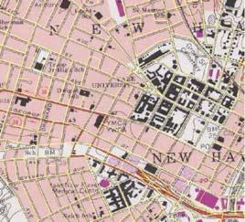
9 17 Landsat TM, FCC541, RANONG How to georeference?


10 Spatial Adjustment of Vector Data


11 Image to Image Open both Images & mark reference point Zoom to other Image which need to correct Marked same point by visualization Importing Data from Sheets Linking with GIS layers


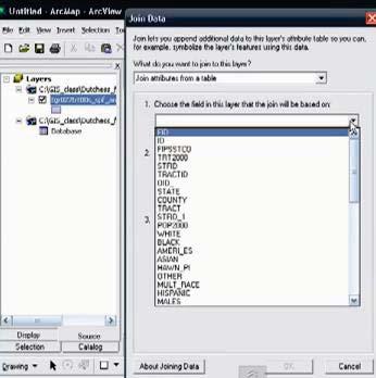
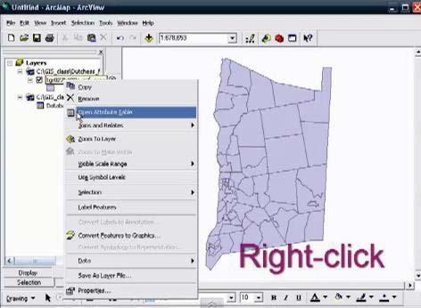
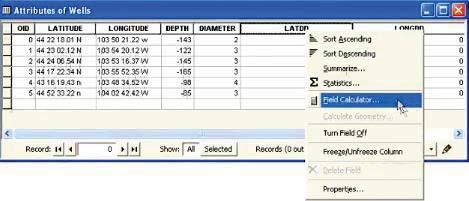
12 Table Join in GIS


13 Raster Overlay Operations

14 Online Maps and Data Availability, Analysis and Information for DRM


15 Georeferenced Disaster Management System user interface Anatomy of a MapServer Application


16 What Does Georeferencing Offer? It will convert and conform all the dataset to a common base map. This map should first be configured into a global standard projection system and coordinate system. The base map should be of required scale based on the application. In addition to a minimum level of georeferencing there can also be further standardization related to coding systems. These codes refer to the vector data and are based on GSDI (Global Spatial Database Infrastructure) guidelines. Each country can have its own standardized coding system of map objects and develop its NSDI (National Spatial Database Infrastructure) in line with GSDI. This will allow the geospatial database to be on same platform for ensuring seamless data integration while handling the trans-boundary projects.


17 Major Hardware/Software The system to create the Georeferenced data and information should consist of hardware/ software and normally comprise of: Hardware Computer Server linked to Internet with various line agencies Computer peripherals such as Data Archival/ Backup Devices Powerful Processor and Graphic Interphase Data output device for softcopy and hardcopy products Scanner Digitizer Reliable Power backup Software Opens Source GIS Software Professional GIS Software Operation and output of the georeferenced platform and system Map/ Satellite Data Acquisition Data Preprocessing/ Georeferencing Data Analysys Geospatial Information Products
18 Proposed Actions to establish the Georeferencing System/ Platform Disaster management needs the recent satellite images superimposed to find the disaster affected areas and plan a strategy to mitigate. Following steps are required to establish the platform/system to provide the Georeferenced information (maps/ satellite data) in near real time: Step 1: Establishment of the Hardware Platform Step 2: Establishment of the Software System to Georeference and conduct the integrated analysis using past and recent spatial data to create information products to support disaster risk reduction and mitigation. Step 3: Establishment of the Human Resource team This team has to support/ organize various tasks: a) Geo-ICT System Management (Data Management, System Management) b) Data acquisition and Georeferencing (Data ordering, data preprocessing and making the data ready for analysis) c) Geospatial Analyst ( To create geoinformation products based on analysis to support decision making) The outcome of the steps 1-3 will create a basic infrastructure system dedicated for supplying the spatial information for disaster management at national level.
19 System Manager Need of skilled workforce A computer engineer to manage the software and hardware, Internet and Intranet management to manage the database and ensure safety to maintain integrity of the database to make the database efficient synchronized for multiple users to facilitate data input and retrieval in the system to ensure the security of the system from unauthorized users Need of skilled workforce (contd.) GIS Technical Assistant for Database Geospatial data input Digitizing / scanning Tabular data linking with maps Geopreprocessing georeferencing with base map encoding the database Socio-economic data input and integration Meteorological Data integration Sensors/ gauge station data integration Developing and finalizing datalayers Preparing metadata
20 GIS Analyst Need of skilled workforce Analysis of data in near real-time To generate hazard map To map risk areas based on magnitude of hazard, exposure and vulnerability Tabular and map reporting Serving the data to user by hardcopy Serving the data to users by softcopy Serving the data to users by internet GIS 21/07/


21 Preventionweb 21/07/ reliefweb 21/07/


22 DESINVENTOR 21/07/ ICIMOD 21/07/

23 21/07/ /07/


24 21/07/ ESCAP-DRR Gateway 21/07/
25 Preventionweb Information- reports/ maps/ meetings, Information exchange tools, Documentation on major projects associated with UN. ReliefWeb timely, reliable and relevant humanitarian information of crisis worldwide and analysis. scan the websites of international and non-governmental organizations, governments, research institutions and the media for news, reports, press releases, appeals, policy documents, analysis and maps related to humanitarian emergencies worldwide. RSS, , Twitter or Facebook). 21/07/ DESINVENTOR Database related to disasters of certain parts of few countries Database is manytimes not updated => need updating Map visualisation available of existing data ICIMOD The Mountain GeoPortal is a virtual platform for geo-information and knowledge resources of the Hindu Kush Himalayan region. The GeoPortal aims establishing a Himalayan Spatial Data Infrastructure (H- SDI) The H-SDI will work through a decentralised network of users and providers of information by forging partnerships with key national institutions in ICIMOD regional member countries and strategic alliances with relevant regional and global partners. 21/07/
26 DRRgateway Targeting the information and networking needs of national disaster management authorities and relevant ministries The Asia-Pacific Gateway for Disaster Risk Reduction and Development: 1. Improves access and aggregates relevant regional information 2. Provides analytical tools / opportunities for mainstreaming DRR 3. Provides a regional online network for information sharing 4. Encourages regional cooperation for mainstreaming DRR into socio-economic development planning Proposed Enhancement under the current Project: Georeferenced WebMap Portal as a common platform for ESCAP member countries with capability to: Visualise maps Query and Simple Analysis Create maps by overlay Create Table/ Charts 21/07/ Example of a WebMap Portal for Disaster Monitoring 21/07/


27 GISTDA 21/07/ /07/

28 21/07/ What proposed geodrm will offer? Data input from various line agencies Data from different satellites Data georeferencing Query/ Retrieval/ Simple Analysis Near Realtime online Information Maps, Tables, Charts Interoperability of Data Data security and integrity
29
Georeferencing and Satellite Image Support: Lessons learned, Challenges and Opportunities
 Georeferencing and Satellite Image Support: Lessons learned, Challenges and Opportunities Shirish Ravan shirish.ravan@unoosa.org UN-SPIDER United Nations Office for Outer Space Affairs (UNOOSA) UN-SPIDER
Use of Geospatial data for disaster managements
 Use of Geospatial data for disaster managements Source: http://alertsystemsgroup.com Instructor : Professor Dr. Yuji Murayama Teaching Assistant : Manjula Ranagalage What is GIS? A powerful set of tools
Roles of NGII in successful disaster management
 The Second UN-GGIM-AP Plenary Meeting Roles of NGII in successful disaster management Republic of Korea Teheran Iran 28 October 2013 Sanghoon Lee, Ph.D. NGII Outline Type of Disasters Occur in Korea Practical
Journey of supporting CSNs to establish Geo-DRM
 Regional Workshop on Geo-referenced Information Systems for Disaster Risk Management (Geo-DRM) 26-27 June 2014 Bangkok, Thailand Journey of supporting CSNs to establish Geo-DRM Keran Wang Chief, Space
Space Application in Support of Land Management for SDG Implementation
 Space Application in Support of Land Management for SDG Implementation Regional Expert Workshop on Land Accounting for SDG Monitoring and Reporting 26 September 2017 Space Application Section Information
Geo-information and Disaster Risk Reduction in the Hindu Kush-Himalayan region
 Geo-information and Disaster Risk Reduction in the Hindu Kush-Himalayan region Basanta Shrestha, Division Head MENRIS, International Centre for Integrated Mountain Development Kathmandu, Nepal The International
GIS and Remote Sensing
 Spring School Land use and the vulnerability of socio-ecosystems to climate change: remote sensing and modelling techniques GIS and Remote Sensing Katerina Tzavella Project Researcher PhD candidate Technology
National Disaster Management Centre (NDMC) Republic of Maldives. Location
 Republic of Maldives. Location") National Disaster Management Centre (NDMC) Republic of Maldives Location Country Profile 1,190 islands. 198 Inhabited Islands. Total land area 300 sq km Islands range b/w 0.2 5 sq km Population approx.
National Disaster Management Centre (NDMC) Republic of Maldives Location Country Profile 1,190 islands. 198 Inhabited Islands. Total land area 300 sq km Islands range b/w 0.2 5 sq km Population approx.
USING GIS CARTOGRAPHIC MODELING TO ANALYSIS SPATIAL DISTRIBUTION OF LANDSLIDE SENSITIVE AREAS IN YANGMINGSHAN NATIONAL PARK, TAIWAN
 CO-145 USING GIS CARTOGRAPHIC MODELING TO ANALYSIS SPATIAL DISTRIBUTION OF LANDSLIDE SENSITIVE AREAS IN YANGMINGSHAN NATIONAL PARK, TAIWAN DING Y.C. Chinese Culture University., TAIPEI, TAIWAN, PROVINCE
Applied Geoscience and Technology Division SOPAC. Joy Papao, Risk Information Systems Officer
 Joy Papao, Risk Information Systems Officer Secretariat of the Pacific Community SPC 22 Pacific Island States Head office in Noumea, New Caledonia 2 Regional offices (Pohnpei and Honiara) 600 staff 9 Technical
Historical background
 Space Technology for Disaster Management in Sri Lanka: Country profile, national perspectives & vision. Professor Ranjith Premalal De Silva Vice Chancellor Uva Wellassa University of Sri Lanka October
SYNERGY OF SATELLITE REMOTE SENSING AND SENSOR NETWORKS ON GEO GRID
 SYNERGY OF SATELLITE REMOTE SENSING AND SENSOR NETWORKS ON GEO GRID National Institute of Advanced Industrial Science and Technology, Japan Yoshio Tanaka (on behalf of AIST GEO Grid team) Contents Brief
Regional EGM on Community of Practice of Georeferenced Information System. for Disaster Risk Management (Geo-DRM) April 2014, Bangkok, Thailand
 April 2014, Bangkok, Thailand") Regional EGM on Community of Practice of Georeferenced Information System for Disaster Risk Management (Geo-DRM) 23-25 April 2014, Bangkok, Thailand Presented By Mukesh Kumar Keshari Ministry of Home Affairs
Regional EGM on Community of Practice of Georeferenced Information System for Disaster Risk Management (Geo-DRM) 23-25 April 2014, Bangkok, Thailand Presented By Mukesh Kumar Keshari Ministry of Home Affairs
GEOMATICS. Shaping our world. A company of
 GEOMATICS Shaping our world A company of OUR EXPERTISE Geomatics Geomatics plays a mayor role in hydropower, land and water resources, urban development, transport & mobility, renewable energy, and infrastructure
ESCAP Promotes Geo-referenced Information System for Disaster Risk Management in Asia and the Pacific
 Third High Level Forum on UNGGIM 22-24 October 2014 Beijing, China ESCAP Promotes Geo-referenced Information System for Disaster Risk Management in Asia and the Pacific Keran Wang Space Applications Section,
Geographic Information Infrastructure and Policy Framework for Sustainable Mountain Development in the Hindu Kush-Himalayas
 Geo SMART ASIA 2017 22-24 August, Kualalampur Geographic Information Infrastructure and Policy Framework for Sustainable Mountain Development in the Hindu Kush-Himalayas Basanta Shrestha, Director Strategic
Disaster Management in Republic of Korea
 The Third UN-GGIM-AP Plenary Meeting Disaster Management in Republic of Korea ~Coordination among NGIA & Other Related Organizations and Recommendations~ Bali Indonesia 10 November 2014 Sanghoon Lee, Ph.D.
Status & Challengers of Cook Islands GEO DRM. Cook Islands GEO S/GIS History
 Status & Challengers of Cook Islands GEO DRM By Patrick A. ARIOKA Planning & Advisory Officer EMERGENCY MANAGEMENT COOK ISLANDS Cook Islands GEO S/GIS History 1990 NZODA/MFAT trained by Landcare Research
GI Technology for Disaster Management
 GI Technology for Disaster Management 17 th ICC on the Regional Space Applications Programme for Sustainable Development (RESAP) 26 th Nov 2013 Bangkok Thailand Period and time of seasonal in thailand
Space Applications for Disaster Risk Reduction and Sustainable Development
 Space Applications for Disaster Risk Reduction and Sustainable Development Space Applications Section (SAS) ICT and Disaster Risk Reduction Division (IDD) UNESCAP Contents I. RESAP Activities 2016-2017
Capacity Building Programme
 Capacity Building Programme 14-17 August 2012 Space Technology for improving Hazard Mapping in Sri Lanka An event organised as a follow up of the UN-SPIDER Technical Advisory Mission to Sri Lanka - 17-21
Eyes in the Sky & Data Analysis.
 Eyes in the Sky & Data Analysis How can we collect Information about Earth Climbing up Trees & Mountains Gathering Food Self Protection Understanding Surroundings By Travelling Collected Information Converted
SDI DEVELOPMENT UPDATES OF INDONESIA
 SDI DEVELOPMENT UPDATES OF INDONESIA DR. ANTONIUS B. WIJANARTO Center For Management And Dissemination Of Geospatial Information GEOSPATIAL INFORMATION AUTHORITY GOVERNMENT OF THE REPUBLIC OF INDONESIA
Geospatial Information and Services for Disasters (GIS4D)
") Geospatial Information and Services for Disasters (GIS4D) 31 July 2017 Tae Hyung KIM ICT and Disaster Risk Reduction Division (IDD) UNESCAP 1 About ESCAP Who is ESCAP? United Nations Economic and Social
Geospatial Information and Services for Disasters (GIS4D) 31 July 2017 Tae Hyung KIM ICT and Disaster Risk Reduction Division (IDD) UNESCAP 1 About ESCAP Who is ESCAP? United Nations Economic and Social
Use of geo-referenced data for DRM in Central Asia, problems and prospective
 Use of geo-referenced data for DRM in Central Asia, problems and prospective Dr. Akylbek Chymyrov Director, Kyrgyz Center of Geoinformation Systems Member of the Public Supervisory Board MES KR KSUCTA,
Uses of free satellite imagery for Disaster Risk Reduction (DRR)
") Centre of Applied Geoscience, Disaster Risk Reduction Research Group, School of Earth and Environmental Science, University of Portsmouth, UK Uses of free satellite imagery for Disaster Risk Reduction
Centre of Applied Geoscience, Disaster Risk Reduction Research Group, School of Earth and Environmental Science, University of Portsmouth, UK Uses of free satellite imagery for Disaster Risk Reduction
July 5-6, 2010 Mytilene, Greece
 Web GIS platform for forest fire management Prof. Kostas Kalabokidis Principal Investigator Univ. of the Aegean, Dept. of Geography, Greece Prof. George Kallos Univ. of Athens, Dept. of Physics, Greece
GIS = Geographic Information Systems;
 What is GIS GIS = Geographic Information Systems; What Information are we talking about? Information about anything that has a place (e.g. locations of features, address of people) on Earth s surface,
Government GIS and its Application for Decision Support
 Government GIS and its Application for Decision Support Zhang Qingpu (Chinese Academy of Surveying and Mapping, Email: zhangqp@casm.ac.cn) Abstract: Application of GIS in government agencies is called
US National Spatial Data Infrastructure A Spatial Framework for Governance and Policy Development to Enable a Location-Based Digital Ecosystem
 GeoPlatform Workshop 7 Dec 2016, Department of the Interior Washington, D.C. US National Spatial Infrastructure A Spatial Framework for Governance and Policy Development to Enable a Location-Based Digital
Report of the Working Group 2 Data Sharing and Integration for Disaster Management *
 UNITED NATIONS E/CONF.104/6 ECONOMIC AND SOCIAL COUNCIL Twentieth United Nations Regional Cartographic Conference for Asia and the Pacific Jeju, 6-9 October 2015 Item 5 of the provisional agenda Report
GEOMATICS AND DISASTER MANAGEMENT: Early Impact assessment in Haiti
 GEOMATICS AND DISASTER MANAGEMENT: Early Impact assessment in Haiti We will talk about... Post-disaster response: the main questions to be answered Post-disaster rapid mapping: the role of Geomatics The
Copernicus Today and Tomorrow GEO Week Group on Earth Observation Geneva, 16 January 2014 The Copernicus Space Infrastructure
 Copernicus Today and Tomorrow GEO Week Group on Earth Observation Geneva, 16 January 2014 The Copernicus Space Infrastructure Thomas Beer, Policy Coordinator, Copernicus Space Office, ESA-ESRIN, Frascati
Building Institutional Capacity for Multi-Hazard Early Warning in Asia and the Pacific Subtitle
 Building Institutional Capacity for Multi-Hazard Early Warning in Asia and the Pacific Subtitle Title Keran Wang Chief, Space Applications Section ICT and Disaster Risk Reduction Division 22 May 2018 Pillar
World Meteorological Organization
 World Meteorological Organization Opportunities and Challenges for Development of Weather-based Insurance and Derivatives Markets in Developing Countries By Maryam Golnaraghi, Ph.D. Head of WMO Disaster
Copernicus Overview and Emergency Management Service
 Copernicus Overview and Emergency Management Service Frédéric BASTIDE European Commission Open informal session of the United Nations Inter-Agency Meeting on Outer Space Activities 12 March 2013, Geneva
CENSUS MAPPING WITH GIS IN NAMIBIA. BY Mrs. Ottilie Mwazi Central Bureau of Statistics Tel: October 2007
 CENSUS MAPPING WITH GIS IN NAMIBIA BY Mrs. Ottilie Mwazi Central Bureau of Statistics E-mail: omwazi@npc.gov.na Tel: + 264 61 283 4060 October 2007 Content of Presentation HISTORICAL BACKGROUND OF CENSUS
LandScan Global Population Database
 LandScan Global Population Database The World s Finest Population Distribution Data Uncommon information. Extraordinary places. LandScan Global Population Database East View Cartographic is now offering
State of Israel Ministry of Housing and Construction Survey of Israel. The Hydrological project case
 State of Israel Ministry of Housing and Construction Survey of Israel The Hydrological project case Survey of Israel Content Introduction To the Survey of Israel The operation assumptions The main responsibilities
INDONESIA S S UPDATE: GEOSPATIAL INFORMATION FOR SUSTAINABLE DEVELOPMENT RELATED TO INA SDI Dr. Asep Karsidi, M.Sc
 INDONESIA S S UPDATE: GEOSPATIAL INFORMATION FOR SUSTAINABLE DEVELOPMENT RELATED TO INA SDI Dr. Asep Karsidi, M.Sc GEOSPATIAL INFORMATION AGENCY 08 August, 2012 OUTLINE 1. Transformation Bakosurtanal into
INSPIRE Basics. Vlado Cetl European Commission Joint Research Centre. https://ec.europa.eu/jrc/
 INSPIRE Basics Vlado Cetl European Commission Joint Research Centre https://ec.europa.eu/jrc/ Serving society Stimulating innovation Supporting legislation Outline SDI? Why European SDI? INSPIRE Policy
Norwegian spatial data infrastructure supporting disaster risk management Norwegian Mapping Authority
 Norwegian spatial data infrastructure supporting disaster risk management Norwegian Mapping Authority Arvid Lillethun, Norwegian Mapping Authority Land and Poverty 2018 Conference, World Bank 19.-23. March
Crowdsourcing approach for large scale mapping of built-up land
 Crowdsourcing approach for large scale mapping of built-up land Kavinda Gunasekara Kavinda@ait.asia Geoinformatics Center Asian Institute of Technology, Thailand. Regional expert workshop on land accounting
Report of PCGIAP to the 18 th United Nations Regional Cartographic Conference for Asia and the Pacific (UNRCC-AP) for the period
 for the period") Permanent Committee on GIS Infrastructure for Asia and the Pacific (PCGIAP) Established in 1995 by a United Nations Resolution Report of PCGIAP to the 18 th United Nations Regional Cartographic Conference
Permanent Committee on GIS Infrastructure for Asia and the Pacific (PCGIAP) Established in 1995 by a United Nations Resolution Report of PCGIAP to the 18 th United Nations Regional Cartographic Conference
Disaster Management & Recovery Framework: The Surveyors Response
 Disaster Management & Recovery Framework: The Surveyors Response Greg Scott Inter-Regional Advisor Global Geospatial Information Management United Nations Statistics Division Department of Economic and
ENV208/ENV508 Applied GIS. Week 1: What is GIS?
 ENV208/ENV508 Applied GIS Week 1: What is GIS? 1 WHAT IS GIS? A GIS integrates hardware, software, and data for capturing, managing, analyzing, and displaying all forms of geographically referenced information.
Progress Report. Flood Hazard Mapping in Thailand
 Progress Report Flood Hazard Mapping in Thailand Prepared By: Mr. PAITOON NAKTAE Chief of Safety Standard sub-beuro Disaster Prevention beuro Department of Disaster Prevention and Mitigation THAILAND E-mail:
Display data in a map-like format so that geographic patterns and interrelationships are visible
 Vilmaliz Rodríguez Guzmán M.S. Student, Department of Geology University of Puerto Rico at Mayagüez Remote Sensing and Geographic Information Systems (GIS) Reference: James B. Campbell. Introduction to
National Remote Sensing Center of China. Space Technology for Sustainable Development in China Status, Achievements and Futures.
 National Remote Sensing Center of China Space Technology for Sustainable Development in China Status, Achievements and Futures Jing Li National Remote Sensing Center of China Ministry of Science and Technology,
Copernicus Overview. Major Emergency Management Conference Athlone 2017
 Copernicus Overview Major Emergency Management Conference Athlone 2017 Copernicus is a European programme implemented by the European Commission. The services address six thematic areas: land, marine,
Geography General Course Year 12. Selected Unit 3 syllabus content for the. Externally set task 2019
 Geography General Course Year 12 Selected Unit 3 syllabus content for the Externally set task 2019 This document is an extract from the Geography General Course Year 12 syllabus, featuring all of the content
DRRM in the Philippines: DRRM Projects, Geoportals and Socio-Economic Integration
 Regional workshop on Geo-referenced information system for improving disaster risk preparedness and management in Asia and the Pacific 26-27 June 2014, UNCC, Bangkok, Thailand DRRM in the Philippines:
The Integration of Land and Marine Spatial Data Set As Part of Indonesian Spatial Data Infrastructure Development
 UNITED NATIONS E/CONF.97/6/IP. 46 ECONOMIC AND SOCIAL COUNCIL Seventeenth United Nations Regional Cartographic Conference for Asia and the Pacific Bangkok, 18-22 September 2006 Item 7 of the provisional
Caribbean Early Warning System Workshop
 Caribbean Early Warning System Workshop Hamonization in Existing EWS April 14-16, 2016 Presenter: Shawn Boyce Caribbean Institute for Meteorology and Hydrology Husbands, St. James Barbados Background Between
What is GIS? Introduction to data. Introduction to data modeling
 What is GIS? Introduction to data Introduction to data modeling 2 A GIS is similar, layering mapped information in a computer to help us view our world as a system A Geographic Information System is a
UN GGIM and National SDI Strategy
 MSDI Open Forum on 26 th January 2016 Contributing to the successful delivery of MSDI UN GGIM and National SDI Strategy Hiroshi Murakami Deputy Administrator Geospatial Information Authority of Japan Geospatial
Climate Resilience Decision Making Framework in the Caribbean. A case of Spatial Data Management
 Climate Resilience Decision Making Framework in the Caribbean A case of Spatial Data Management Bishwa Pandey Sr. Data Management Specialist The World Bank Background The mission of The World Bank s Latin
The UN-GGIM: Europe core data initiative to encourage Geographic information supporting Sustainable Development Goals Dominique Laurent, France
 INSPIRE conference Strasbourg 6 September 2017 The UN-GGIM: Europe core data initiative to encourage Geographic information supporting Sustainable Development Goals Dominique Laurent, France Introduction
Statewide Topographic Mapping Program
 Statewide Topographic Mapping Program February 28, 2018 www.dotd.la.gov Outline Purpose of the Statewide Topographic Mapping Program History Breakdown of R.S. 48:36 - Topographic Mapping Statewide Topographic
Manitoba s Elevation (LiDAR) & Imagery Datasets. Acquisition Plans & Opportunities for Collaboration
 & Imagery Datasets. Acquisition Plans & Opportunities for Collaboration") Manitoba s Elevation (LiDAR) & Imagery Datasets Acquisition Plans & Opportunities for Collaboration Manitoba Planning Conference May 2017 Presentation Outline Manitoba s Elevation (LiDAR) and Imagery Datasets
Manitoba s Elevation (LiDAR) & Imagery Datasets Acquisition Plans & Opportunities for Collaboration Manitoba Planning Conference May 2017 Presentation Outline Manitoba s Elevation (LiDAR) and Imagery Datasets
Geospatial SDI Portal for effective Governance of Pune METROPOLIS region
 Geospatial SDI Portal for effective Governance of Pune METROPOLIS region Mr. Praveen Gautam Senior Manager 19 th January 2018 PMRDA Overview Provide a Spatial Framework for the entire region with various
Data Origin. Ron van Lammeren CGI-GIRS 0910
 Data Origin Ron van Lammeren CGI-GIRS 0910 How to obtain geodata? Geo data initiative Executive Order 12906, "Coordinating Geographic Data Acquisition and Access: The National Spatial Data Infrastructure,"
Techniques for Science Teachers: Using GIS in Science Classrooms.
 Techniques for Science Teachers: Using GIS in Science Classrooms. After ESRI, 2008 GIS A Geographic Information System A collection of computer hardware, software, and geographic data used together for
Realizing benefits of Spatial Data Infrastructure A user s perspective from Environment Agency - Abu Dhabi
 Realizing benefits of Spatial Data Infrastructure A user s perspective from Environment Agency - Abu Dhabi Anil Kumar Director, Environment Information Management 26 April 2012 Geospatial World Forum,
CLICK HERE TO KNOW MORE
 CLICK HERE TO KNOW MORE Geoinformatics Applications in Land Resources Management G.P. Obi Reddy National Bureau of Soil Survey & Land Use Planning Indian Council of Agricultural Research Amravati Road,
USE OF GEOREFERENCE INFORMATION FOR DRM Arnob Bormdoi Research Associate, GIC
 USE OF GEOREFERENCE INFORMATION FOR DRM Arnob Bormdoi Research Associate, GIC CONTENTS INTRODUCTION THE IMPORTANCE OF SPATIAL INFORMATION CASE STUDIES SUMMARY INTRODUCTION The process of defining how raster
Part : General Situation of Surveying and Mapping. The Development of Surveying and Mapping in China. The contents
 The Development of Surveying and Mapping in China Dr. Ping Xiao China.P.R The contents Part : General Situation of Surveying and Mapping 1. The legal systems of surveying and mapping 2. The technologies
Introduction to GIS. Dr. M.S. Ganesh Prasad
 Introduction to GIS Dr. M.S. Ganesh Prasad Department of Civil Engineering The National Institute of Engineering, MYSORE ganeshprasad.nie@gmail.com 9449153758 Geographic Information System (GIS) Information
Overview of Technical Advisory Missions
 Expert Group Meeting (EGM) on Georeferenced Information Systems for Disaster Risk Management (Geo-DRM) and sustaining the Community of Practice (COP) 23-25 April 2014 Bangkok Overview of Technical Advisory
Country Report Nepal Geospatial Data Sharing Initiatives of Survey Department Supporting Disaster Management
 Third JPTM Step 2 for Sentinel Asia 6-8 July, 2010 Manila, The Philippines Country Report Nepal Geospatial Data Sharing Initiatives of Survey Department Supporting Disaster Management Durgendra M Kayastha
GIS in Weather and Society
 GIS in Weather and Society Olga Wilhelmi Institute for the Study of Society and Environment National Center for Atmospheric Research WAS*IS November 8, 2005 Boulder, Colorado Presentation Outline GIS basic
IMPLEMENTING GOVERNMENT-WIDE ENTERPRISE GIS; THE FEDERATED MODEL
 IMPLEMENTING GOVERNMENT-WIDE ENTERPRISE GIS; THE FEDERATED MODEL James E. Mitchell, Ph. D. IT GIS Manager Louisiana Department of Transportation and Development presented at the ESRI International Users
Syllabus Post Graduate Diploma in Disaster Management (PGDDM)
") Syllabus Post Graduate Diploma in Disaster Management (PGDDM) Programme Objective: The Programme has been framed with an intention to provide a general concept in the dimensions of disasters caused by
Syllabus Post Graduate Diploma in Disaster Management (PGDDM) Programme Objective: The Programme has been framed with an intention to provide a general concept in the dimensions of disasters caused by
Grant Agreement No. EIE/07/595/SI BEn
 Biomass energy register for sustainable site development for European regions Grant Agreement No. EIE/07/595/SI2.499697 BEn Biomass energy register for sustainable site development for European regions
Spatially Enabled Society
 International Seminar on Land Administration Trends and Issues in Asia and the Pacific Region Spatially Enabled Society Abbas Rajabifard Vice Chair PCGIAP-WG3 Vice-President (President Elect), GSDI Association
Data Origin. How to obtain geodata? Ron van Lammeren CGI-GIRS 0910
 Data Origin How to obtain geodata? Ron van Lammeren CGI-GIRS 0910 Spatial Data interest Improvement of policy making. ± 90% of all information used by government has spatial characteristics SPATIAL INFORMATION
GIS: a common operational picture for public safety and emergency management
 Safety and Security Engineering IV 455 GIS: a common operational picture for public safety and emergency management J. Perdikaris School of Engineering, University of Guelph, Canada Abstract Not so long
Geospatial Information for Disaster Risk Management in Asia-Pacific Region
 Geospatial Information for Disaster Risk Management in Asia-Pacific Region Ram S. Tiwaree, Dr.Eng. Space Applications Section Information and Communications Technology and Disaster Risk Reduction Division
Use of Climate information in Disaster Risk Management in Zimbabwe
 Use of Climate information in Disaster Risk Management in Zimbabwe WMO Regional Technical Meeting & User/CONOPS Workshop, 28 th October 2015 Lameck Betera Department of Civil Protection Institutional Arrangements
RESAP Progress Report
 RESAP Progress Report December 2016 to October 2017 Presentation to the Twenty-first session of the Intergovernmental Consultative Committee on the Regional Space Applications Programme for Sustainable
Voices from Private Sector: Insights for Future NSDI Development in Indonesia
 Voices from Private Sector: Insights for Future NSDI Development in Indonesia Ta n d a n g Yu l i a d i D w i P u t ra, Ryosuke S h i b a s a k i I n st i t u t e o f I n d u st r i a l S c i e n c e,
NCC roles in successful disaster response I.R.IRAN
 The Second UN-GGIM-AP Plenary Meeting NCC roles in successful disaster response I.R.IRAN Teheran Iran 28-30 October 2013 Ali Javidaneh Technical Deputy of National Cartographic Center (NCC) Outline Types
Global Map: A Tool for Disaster Mitigation for the Asia and Pacific Region
 Global Map: A Tool for Disaster Mitigation for the Asia and Pacific Region D. R. Fraser Taylor Chair, International Steering Committee for Global Mapping (ISCGM) fraser_taylor@carleton.ca www. 18 th United
NATIONAL FRAMEWORK FOR FLOOD DISASTER MANAGEMENT IN INDONESIA. 11 th GEOSS ASIA PASIFIC SYMPOSIUM Kyoto, October 2018
 NATIONAL FRAMEWORK FOR FLOOD DISASTER MANAGEMENT IN INDONESIA 11 th GEOSS ASIA PASIFIC SYMPOSIUM Kyoto, 24-26 October 2018 1 OUTLINE Disasters in Indonesia The Disaster Management Mechanism Current Status
Spanish national plan for land observation: new collaborative production system in Europe
 ADVANCE UNEDITED VERSION UNITED NATIONS E/CONF.103/5/Add.1 Economic and Social Affairs 9 July 2013 Tenth United Nations Regional Cartographic Conference for the Americas New York, 19-23, August 2013 Item
Transactions on Information and Communications Technologies vol 18, 1998 WIT Press, ISSN
 STREAM, spatial tools for river basins, environment and analysis of management options Menno Schepel Resource Analysis, Zuiderstraat 110, 2611 SJDelft, the Netherlands; e-mail: menno.schepel@resource.nl
Integration of Geo spatial and Statistical Information: The Nepelese Experience
 Integration of Geo spatial and Statistical Information: The Nepelese Experience Krishna Raj B.C. Joint Secretary Ministry of Land Reform and Management, Nepal 11 June, 2014 Presentation Outline The Country
Adding value to Copernicus services with member states reference data
 www.eurogeographics.org Adding value to Copernicus services with member states reference data Neil Sutherland neil.sutherland@os.uk GIS in the EU 10 November 2016 Copyright 2016 EuroGeographics 61 member
Disaster RISK Management : Bhutanese Scenario
 Disaster RISK Management : Bhutanese Scenario Expert Group Meeting (EGM) on Geo-referenced Information Systems for Disaster Risk Management (Geo-DRM) and sustaining the Community of Practice (COP), Bangkok,
Session 9 Spatial Decision Support Systems (SDSS)
") Session 9 Spatial Decision Support Systems (SDSS) Lead facilitator Dr. Gerard Kelly Learning Objectives The aim of this session is to review and understand the applications of a GIS-based spatial decision
Session 9 Spatial Decision Support Systems (SDSS) Lead facilitator Dr. Gerard Kelly Learning Objectives The aim of this session is to review and understand the applications of a GIS-based spatial decision
Geo-portal as a Data Sharing Platform for Early Warning System in the Pacific
 EXPERT SEMINAR ON INTEGRATED STATISTICS FOR THE SDGS Geo-portal as a Data Sharing Platform for Early Warning System in the Pacific 11-13 DECEMBER 2017 BANGKOK, THAILAND Youjin Choe Natural disasters and
Interpretive Map Series 24
 Oregon Department of Geology and Mineral Industries Interpretive Map Series 24 Geologic Hazards, and Hazard Maps, and Future Damage Estimates for Six Counties in the Mid/Southern Willamette Valley Including
Earth Observation for Emergency Response and the International Charter on Space and Major Disasters.
 Earth Observation for Emergency Response and the International Charter on Space and Major Disasters. Case studies of the 2016 Alberta wildfires and 2017 Québec flooding Simon Tolszczuk-Leclerc 1, Brad
Strategic Framework on Geospatial Information and Services for Disasters
 Strategic Framework on Geospatial Information and Services for Disasters Case Studies for the Caribbean and the Philippines --- Kunming Forum on United Nations Global Geospatial Information Management
Building Institutional Capacity for Multi-Hazard Early Warning in Pacific Countries Subtitle
 Building Institutional Capacity for Multi-Hazard Early Warning in Pacific Countries Subtitle Title Keran Wang Chief, Space Applications Section ICT and Disaster Risk Reduction Division 30 March 2018 Slide
Brazil Paper for the. Second Preparatory Meeting of the Proposed United Nations Committee of Experts on Global Geographic Information Management
 Brazil Paper for the Second Preparatory Meeting of the Proposed United Nations Committee of Experts on Global Geographic Information Management on Data Integration Introduction The quick development of
GMES Service for Geospatial Reference Data Access (RDA) Covering Areas Outside Europe
 Covering Areas Outside Europe") INSPIRE Conference 2011 Edinburgh 27 June - 1 July GMES Service for Geospatial Reference Data Access (RDA) Covering Areas Outside Europe Andrea Ajmar, Simone Balbo, Piero Boccardo, Simone Dalmasso, Anna
INSPIRE Conference 2011 Edinburgh 27 June - 1 July GMES Service for Geospatial Reference Data Access (RDA) Covering Areas Outside Europe Andrea Ajmar, Simone Balbo, Piero Boccardo, Simone Dalmasso, Anna
Country Report Vanuatu
 Country Report Vanuatu Ministry Infrastructure and Public Utilities. Application of Space Technology and the Geographic information system for DRR and Sustainable Development 18 th 22 nd December 2012
THE 3D SIMULATION INFORMATION SYSTEM FOR ASSESSING THE FLOODING LOST IN KEELUNG RIVER BASIN
 THE 3D SIMULATION INFORMATION SYSTEM FOR ASSESSING THE FLOODING LOST IN KEELUNG RIVER BASIN Kuo-Chung Wen *, Tsung-Hsing Huang ** * Associate Professor, Chinese Culture University, Taipei **Master, Chinese
STATUS OF MARINE SPATIAL DATA INFRASTRUCTURE
 STATUS OF MARINE SPATIAL DATA INFRASTRUCTURE IN PACIFIC ISLAND COUNTRIES 26 th January, 2016 7 th IHO Marine Spatial Data Infrastructure Working Group Meeting Tokyo Sachindra Singh Senior Geospatial Systems