Geospatial Information for Disaster Risk Management in Asia-Pacific Region
|
|
|
- Barbara Gibbs
- 6 years ago
- Views:
Transcription
, ESCAP tiwaree@un.")
1 Geospatial Information for Disaster Risk Management in Asia-Pacific Region Ram S. Tiwaree, Dr.Eng. Space Applications Section Information and Communications Technology and Disaster Risk Reduction Division (IDD), ESCAP The Nineteenth United Nations Regional Cartographic Conference for Asia and the Pacific, 29 Oct- 01 Nov 2012, Bangkok, Thailand
2 ESCAP brief introduction Coverage Disaster losses in Asia-Pacific region Disaster impacts to low capacity countries Disaster impacts on Millennium Development Goals (MDGs) Current problems, HFA and role of geo-referencing for DRM ESCAP initiative: Improving disaster risk preparedness in the ESCAP region Outcomes of the EGM in Feb 12 in BKK & regional workshop for SSWA & NCA (sub-regions) in July 12 in KTM Ongoing activities and way forward


3 ESCAP Regional Arm of the United Nations The regional development arm of the United Nations for the Asia-Pacific region -11 of the 5 United Nations regional commissions 62 Governments 58 within the region, i.e., from Turkey in the west to Kiribati in the east, and from the Russian Federation in the north to New Zealand in the south The largest United Nations body/commission serving the Asia-Pacific region (in terms of population & land area) with over 600 staff (about 200 P-staff) P

4 ESCAP Regional Arm of the United Nations

5 ESCAP Regional Arm of the United Nations

")
6 ESCAP Regional Arm of the United Nations Established in 1947 with its headquarters in Bangkok, Thailand since 1949, ESCAP seeks to overcome some of the region s greatest challenges. It carries out work in the following areas/subprogrammes: Macroeconomic Policy and Development Statistics Trade and Investment Transport Environment and sustainable development Information and Communications Technology and Disaster Risk Reduction Social Development Sub-regional Offices (4) Has 5 regional institutions - APCTT, APCICT, UNAPCAEM, CAPSA, SIAP Policy analysis Technical Cooperation Projects Advisory Services Capacity Building
7 ESCAP Regional Arm of the United Nations The promotion of inclusive and sustainable economic and social development in Asia and the Pacific, with the overall goal of achieving the Millennium Development Goals. Collectively, the eight mutually supportive subprogrammes achieve the following three development results: aim to 1. Member Governments have more effective, inclusive and sustainable development policies for addressing development from a multi-disciplinary perspective, to narrow development gaps and build resiliency; 2. Global processes are shaped by a stronger coordinated regional voice and countries are supported in implementing international commitments; 3. Regional cooperation mechanisms and institutional frameworks are in place to promote regional integration and inclusive development. opment.

8 75% of deaths due to disasters from 1970 to 2011 from Asia Pacific GEO REF Information Sharing
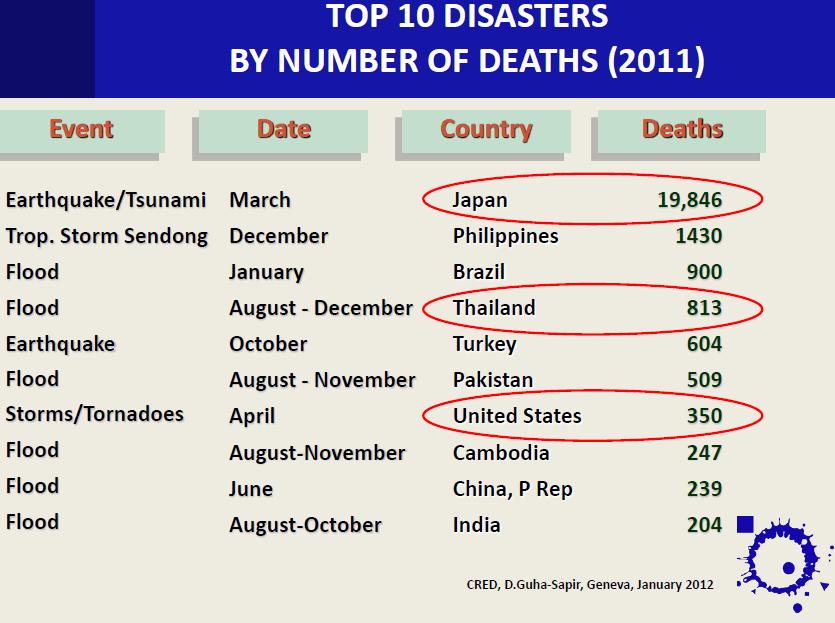
9

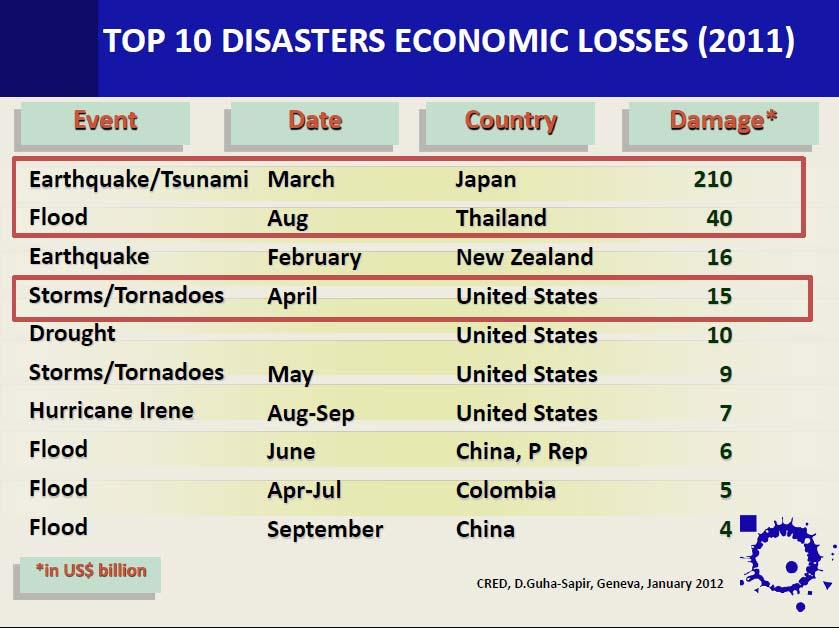
10 Economic losses in 2011 alone equate to 80% of all losses between 2000 and 2009 GEO REF Information Sharing
11


12 For low capacity countries, the cumulative effect of small scale disasters increases vulnerability
13 Example of the Maldives GEO REF Information Sharing

14 Progress towards achieving the MDGs is undermined Primary school enrolment reduced after disasters in Pakistan
15 effects Problem Tree More deaths, casualties and damage due to disaster events Delays in disaster response Disaster risk reduction initiatives are not evidence-based Lack of timely and accurate information for disaster management Lack of government capacities in the implementation of HFA through the use of geo-referenced information tools for the implementation of disaster risk preparedness and timely early recovery efforts in Asia & the Pacific LDCs, LLDCs, SIDS & other high risk developing countries Lack of government capacities to establish and use a geo-referenced information platform Lack of communities of practice for spatial data infrastructure linked into a regional level network supportive of disaster risk identification, preparedness and related information sharing and analysis
16 Hyogo Framework for Action (HFA): Priorities for action III : Outcome of World Conference on Disaster Reduction, Kobe, Japan Policies and governance: ensure that disaster risk reduction is a national and local priority with strong institutional basis for implementation. 2. Risk identification: identify, assess and monitor disaster risks and enhance early warning. 3. Knowledge: use knowledge, innovation and education to build a culture of safety and resilience at all levels. 4. Reducing the underlying risk factors: 1. Environment and natural resources management. 2. Social and economic development practices. 3. Land-use planning, building codes and other technical measures. 5. Strengthen disaster preparedness for effective response
17 Role of Geospatial Information in accelerating HFA implementation HFA Priority of Action Specific role that Geo-information could play Policies and governance Risk identification Knowledge Reducing the underlying risk factors Strengthen disaster preparedness for effective response Nationwide risk assessment, Spatial mapping for land use planning incorporating risk reduction strategies Spatially - identify, assess and monitor disaster risks to enhance the effectiveness of early warning systems. Understanding risk unknown to known, capturing risk dynamics, ecological foundations of disaster risk.. Baseline information for - Environment and natural resources management. Social and economic development practices. Land-use planning, building codes and other technical measures. Access to geo-spatial info for disaster monitoring, damage and loss assessment (DaLA), Post-disaster recovery and rehabilitation planning Confidential Slide 17
 MODIS Terra")
18 Example Geospatial information for DRM GEO REF Information Sharing Indus valley before (Sept 2009) and after 2010 Pakistan floods (Sept 2010) highlighting extensive risks through out the river basin (GIS databases with census and survey data not shown in the figure due to limit of the resolution) MODIS Terra Image

19 Example Geospatial information for DRM GEO REF Information Sharing Intensive flood risk captured of Dera Ismail Khan District, captured during Pakistan floods, Aug 6, 2010
20 Mandates Geospatial information for DRM Hyogo Framework for Action or HFA ( ): has set the goals and priorities for building the resilience of the nations and community to disasters. UN-GGIM: The High Level Forum on United Nations Global Geospatial Information Management (UN-GGIM) in Seoul, last year spelt out the need for full interoperability of multi-dimensional geospatial information and integration with other data sources at national, regional, and global level, in order to provide an effective information base for DRM and development. Rio+20: United Nations Conference on Sustainable Development (UNCSD) June 2012, highlighted the importance of comprehensive hazard and risk assessments, and knowledge- and information sharing, including reliable geospatial information
21 ESCAP initiative: Improving disaster risk preparedness in the ESCAP region ESCAP has embarked on a project entitled Improving disaster risk preparedness in the ESCAP region. The project aims to address the issue of non-interoperability of georeference/geospatial information and strengthen the capacity of governments (disaster management authorities) in Asia-Pacific region (LDCs, LLDCs, SIDS, and some high risk developing countries), in the implementation of the HFA through the use of georeferenced/geospatial information tools for the implementation of disaster risk preparedness, and timely early recovery efforts or Enhance the capacity of ESCAP member states towards managing the disaster risks more efficiently and effectively, and reduce losses, and build resilience to hazards through the use/sharing of standardized geo-spatial information among and within the countries.
22 Expert Group Meeting on Geo-referenced Disaster Information Management System in Asia-Pacific Region held in Bangkok in February 2012-Outcomes Discussion of the findings of the geo-referenced information needs and gaps assessment survey, Online communities of practices (COP) for spatial data infrastructure linked to a regional level network supportive of DRM Development of geo-referenced information in support of DRR (Geo- DRM) and associated capacity development activities for developing countries: (i)training workshops for policy makers (awareness) and professional/technical staff (in-depth training where Geo-DRM will be developed) and technical assistance/advisory services.
23 Regional Workshop on Geo-referenced Disaster Information Management System for South and South-west Asia and Central Asia held in Kathmandu in July 2012 Geo-referenced information for disaster risk management (Geo- DRM) concepts, needs Geo-DRM systems Overviews Geo-DRM systems at regional/sub-regional levels Country presentations Institutional and policy issues and networking Demonstrations of Geo-DRM system Way forward Study visit
24 Regional Workshop outcomes GEO REF Information Sharing Harnessing the potentials of Geo-DRM portal for facilitating data sharing was realized. The Geo-DRM portal was envisaged as an integral part of ESCAP DRR Gateway. The Geo-DRM was recommended to be dovetailed to the existing initiatives at country as well as sub-regional levels. High level dialogues were advised to initiate with South Asian Association of Regional Cooperation (SAARC) and similar other initiatives through ESCAP SRO-SSWA, New Delhi, and SONCA, Almaty. Technical assistance for feasibility study towards implementing Geo-DRM: requested by Afghanistan, Bangladesh, Bhutan, Kyrgyzstan, Maldives and Nepal followed up by capacity development training through ESCAP RESAP education & training network- recommended.
25 On-going activities/way forward GEO REF Information Sharing Work to develop national geo-drm portals and linkage with regional level network (Asia-pacific Gateway for DRM) and to establish Community of practice (COP) including dialogues with subregional organizations, preparation for technical assistance missions; Preparation on Capacity development activities: Awareness building workshop for South-east and East Asia, and Pacific similar to that we organized for South and South-west Asia and Central and North Asia; and Indepth training for selected countries including for those countries where geo-portals will be established. Launch of Geo-DRM network and COP during an EGM and Review Regional Workshop. Challenges: sustainability of national geo-portals; network of experts/cop.

26 Right Information to right people at right time makes a difference but possible if there is regional cooperation in place
27 GEO REF Information Sharing
National workshop on sustainable urban and industry development in Mongolia objective, expected outcomes and schedule
 GEO-REF Information Eco-Efficient Urban Infrastructure, and Platform Green for & Disaster Livable Management Cities National workshop on sustainable urban and industry development in Mongolia objective,
National workshop on Eco-efficient Water Infrastructure for Sustainable Urban Development in Nepal objectives. expected outcomes & schedule
 GEO-REF Information Sharing Eco-Efficient water Infrastructure, National workshop on Eco-efficient Water Infrastructure for Sustainable Urban Development in Nepal objectives. expected outcomes & schedule
Journey of supporting CSNs to establish Geo-DRM
 Regional Workshop on Geo-referenced Information Systems for Disaster Risk Management (Geo-DRM) 26-27 June 2014 Bangkok, Thailand Journey of supporting CSNs to establish Geo-DRM Keran Wang Chief, Space
ESCAP Promotes Geo-referenced Information System for Disaster Risk Management in Asia and the Pacific
 Third High Level Forum on UNGGIM 22-24 October 2014 Beijing, China ESCAP Promotes Geo-referenced Information System for Disaster Risk Management in Asia and the Pacific Keran Wang Space Applications Section,
Overview of Technical Advisory Missions
 Expert Group Meeting (EGM) on Georeferenced Information Systems for Disaster Risk Management (Geo-DRM) and sustaining the Community of Practice (COP) 23-25 April 2014 Bangkok Overview of Technical Advisory
Geospatial Information and Services for Disasters (GIS4D)
") Geospatial Information and Services for Disasters (GIS4D) 31 July 2017 Tae Hyung KIM ICT and Disaster Risk Reduction Division (IDD) UNESCAP 1 About ESCAP Who is ESCAP? United Nations Economic and Social
Geospatial Information and Services for Disasters (GIS4D) 31 July 2017 Tae Hyung KIM ICT and Disaster Risk Reduction Division (IDD) UNESCAP 1 About ESCAP Who is ESCAP? United Nations Economic and Social
Use of geo-referenced data for DRM in Central Asia, problems and prospective
 Use of geo-referenced data for DRM in Central Asia, problems and prospective Dr. Akylbek Chymyrov Director, Kyrgyz Center of Geoinformation Systems Member of the Public Supervisory Board MES KR KSUCTA,
Geospatial Technologies for Resources Planning & Management
 Geospatial Technologies for Resources Planning & Management Lal Samarakoon, PhD Director, Geoinformatics Center Asian Institute of Technology, Thailand Content Geoinformatics for SDG Information Integration
Sub-regional Training on development of Geo-referenced Disaster Risk Management Information Systems for SAARC countries
 Sub-regional Training on development of Geo-referenced Disaster Risk Management Information Systems for SAARC countries Jointly organized by Economic and Social Commission for Asia and the Pacific and
Background Document: Report of the Regional Committee of United Nations Global Geospatial Information Management for Asia and the Pacific
 Background Document: Report of the Regional Committee of United Nations Global Geospatial Information Management for Asia and the Pacific 1. Summary 1. This report highlights the activities carried out
Project Evaluation Report Improving disaster risk preparedness in the Economic and Social Commission for Asia and the Pacific region
 Project Evaluation Report Improving disaster risk preparedness in the Economic and Social Commission for Asia and the Pacific region September 2014 Evaluator Mihir R. Bhatt Page 1 of 72 ACKNOWLEDGEMENTS
Space Application in Support of Land Management for SDG Implementation
 Space Application in Support of Land Management for SDG Implementation Regional Expert Workshop on Land Accounting for SDG Monitoring and Reporting 26 September 2017 Space Application Section Information
Report of the Working Group 2 Data Sharing and Integration for Disaster Management *
 UNITED NATIONS E/CONF.104/6 ECONOMIC AND SOCIAL COUNCIL Twentieth United Nations Regional Cartographic Conference for Asia and the Pacific Jeju, 6-9 October 2015 Item 5 of the provisional agenda Report
Space Applications for Disaster Risk Reduction and Sustainable Development
 Space Applications for Disaster Risk Reduction and Sustainable Development Space Applications Section (SAS) ICT and Disaster Risk Reduction Division (IDD) UNESCAP Contents I. RESAP Activities 2016-2017
UN GGIM and National SDI Strategy
 MSDI Open Forum on 26 th January 2016 Contributing to the successful delivery of MSDI UN GGIM and National SDI Strategy Hiroshi Murakami Deputy Administrator Geospatial Information Authority of Japan Geospatial
South and South-West Asia LLDCs
 International support measures to South and South-West Asia LLDCs Nagesh Kumar Director, ESCAP South and South West Asia Office And ESCAP Chief Economist ESCAP/OHRLLS/ECE/Government / / of Lao PDR Final
Building Institutional Capacity for Multi-Hazard Early Warning in Asia and the Pacific Subtitle
 Building Institutional Capacity for Multi-Hazard Early Warning in Asia and the Pacific Subtitle Title Keran Wang Chief, Space Applications Section ICT and Disaster Risk Reduction Division 22 May 2018 Pillar
Disaster Management & Recovery Framework: The Surveyors Response
 Disaster Management & Recovery Framework: The Surveyors Response Greg Scott Inter-Regional Advisor Global Geospatial Information Management United Nations Statistics Division Department of Economic and
Economic and Social Council
 United Nation E/C.20/2012/4/Add.1 Economic and Social Council Distr.: General 2 July 2012 Original: English Committee of Experts on Global Geospatial Information Management Second session New York, 13-15
Building Institutional Capacity for Multi-Hazard Early Warning in Pacific Countries Subtitle
 Building Institutional Capacity for Multi-Hazard Early Warning in Pacific Countries Subtitle Title Keran Wang Chief, Space Applications Section ICT and Disaster Risk Reduction Division 30 March 2018 Slide
RESAP Progress Report
 RESAP Progress Report December 2016 to October 2017 Presentation to the Twenty-first session of the Intergovernmental Consultative Committee on the Regional Space Applications Programme for Sustainable
From PCGIAP to UN GGIM AP: A Regional Perspective on GGIM
 Regional Committee of United Nations Global Geospatial Information Management for Asia and the Pacific (UN-GGIM-AP) Established by a United Nations Resolution From PCGIAP to UN GGIM AP: A Regional Perspective
Economic and Social Council
 United Nations Economic and Social Council Distr.: General 2 July 2012 E/C.20/2012/10/Add.1 Original: English Committee of Experts on Global Geospatial Information Management Second session New York, 13-15
Regional EGM on Community of Practice of Georeferenced Information System. for Disaster Risk Management (Geo-DRM) April 2014, Bangkok, Thailand
 April 2014, Bangkok, Thailand") Regional EGM on Community of Practice of Georeferenced Information System for Disaster Risk Management (Geo-DRM) 23-25 April 2014, Bangkok, Thailand Presented By Mukesh Kumar Keshari Ministry of Home Affairs
Regional EGM on Community of Practice of Georeferenced Information System for Disaster Risk Management (Geo-DRM) 23-25 April 2014, Bangkok, Thailand Presented By Mukesh Kumar Keshari Ministry of Home Affairs
Regional Integration and Cooperation (Priority 4)
") Regional Integration and Cooperation (Priority 4) Andrzej Bolesta Economic Affairs Officer Macroeconomic Policy and Financing for Development Division United Nations Economic and Social Commission for
Regional Integration and Cooperation (Priority 4) Andrzej Bolesta Economic Affairs Officer Macroeconomic Policy and Financing for Development Division United Nations Economic and Social Commission for
ENHANCING THE SHARE OF LLDCs IN. (Priority 3 of APoA) Dr Mia Mikic Chief, Trade Policy and Analysis Section Trade and Investment Division
 Dr Mia Mikic Chief, Trade Policy and Analysis Section Trade and Investment Division") ESCAP/OHRLLS/ECE/Government of Lao PDR Final Regional Review of the AlmatyProgrammeof of Action 5 7 March 2013, Vientiane, Lao PDR ENHANCING THE SHARE OF LLDCs IN GLOBAL TRADE FLOWS AND TRADE FACILITATION
ESCAP/OHRLLS/ECE/Government of Lao PDR Final Regional Review of the AlmatyProgrammeof of Action 5 7 March 2013, Vientiane, Lao PDR ENHANCING THE SHARE OF LLDCs IN GLOBAL TRADE FLOWS AND TRADE FACILITATION
Disaster RISK Management : Bhutanese Scenario
 Disaster RISK Management : Bhutanese Scenario Expert Group Meeting (EGM) on Geo-referenced Information Systems for Disaster Risk Management (Geo-DRM) and sustaining the Community of Practice (COP), Bangkok,
Geographic Information Infrastructure and Policy Framework for Sustainable Mountain Development in the Hindu Kush-Himalayas
 Geo SMART ASIA 2017 22-24 August, Kualalampur Geographic Information Infrastructure and Policy Framework for Sustainable Mountain Development in the Hindu Kush-Himalayas Basanta Shrestha, Director Strategic
ECONOMIC AND SOCIAL COUNCIL
 UNITED NATIONS E/CONF.102/3 ECONOMIC AND SOCIAL COUNCIL Nineteenth United Nations Regional Cartographic Conference for Asia and the Pacific Bangkok, 29 October 1 November 2012 Item 4 of the provisional
Geo-information and Disaster Risk Reduction in the Hindu Kush-Himalayan region
 Geo-information and Disaster Risk Reduction in the Hindu Kush-Himalayan region Basanta Shrestha, Division Head MENRIS, International Centre for Integrated Mountain Development Kathmandu, Nepal The International
Georeferencing and Satellite Image Support: Lessons learned, Challenges and Opportunities
 Georeferencing and Satellite Image Support: Lessons learned, Challenges and Opportunities Shirish Ravan shirish.ravan@unoosa.org UN-SPIDER United Nations Office for Outer Space Affairs (UNOOSA) UN-SPIDER
ESCAP Technical Paper Information and Communications Technology and Disaster Risk Reduction Division
 ESCAP Technical Paper Information and Communications Technology and Disaster Risk Reduction Division Using Space-based Applications and Information Available through the ESCAP-established Regional Cooperation
Status & Challengers of Cook Islands GEO DRM. Cook Islands GEO S/GIS History
 Status & Challengers of Cook Islands GEO DRM By Patrick A. ARIOKA Planning & Advisory Officer EMERGENCY MANAGEMENT COOK ISLANDS Cook Islands GEO S/GIS History 1990 NZODA/MFAT trained by Landcare Research
Oman NSDI Business Values and Future Directions. Hassan Alawi Alghazali Acting Director General National Spatial Data Infrastructure
 Oman NSDI Business Values and Future Directions Hassan Alawi Alghazali Acting Director General National Spatial Data Infrastructure Presentation Outline Geospatial Maturity Current Challenges NCSI s Role
FIG Asia Pacific Capacity Development Network
 FIG Asia Pacific Capacity Development Network Report to the 41th General Assembly FIG Congress 2018, Istanbul - Turkey Rob Sarib Chair FIG Asia Pacific Capacity Development Network (AP CDN) Story of the
GENERAL RECOMMENDATIONS. Session 7. Breakout discussion. discuss on regional and interregional. proposals 1. COLLABORATION BETWEEN PROGRAMMES
 Session 7 24 July 2016, 9.00-11.00 Breakout discussion on regional and interregional joint project proposals Mr Shahbaz Khan summarized the two days of presentations and exchanges and requested the participants
Global Geodetic Reference Frame GGRF & Implications for GNSS
 Global Geodetic Reference Frame GGRF & Implications for GNSS On behalf of Gary Johnston Chair GIAC, Ruth Neilan Vice Chair, Global Geodetic Observing System ICG-9 Prague, 10 November 2014 UN GGRF Working
LLDCS IN THE GLOBAL AGENDA: CHALLENGES AND INTERNATIONAL RESPONSES CHAIR OF THE GROUP OF LLDCS IN GENEVA
 LLDCS IN THE GLOBAL AGENDA: CHALLENGES AND INTERNATIONAL RESPONSES CHAIR OF THE GROUP OF LLDCS IN GENEVA E X P E R T G R O U P M E E T I N G O N T H E M I D T E R M R E V I E W O F T H E V P O A F O R
Pacific Geospatial and Surveying Council (PGSC) Geospatial and GNSS CORS Infrastructure Forum. Kuala Lumpur October
 Geospatial and GNSS CORS Infrastructure Forum. Kuala Lumpur October") Pacific Geospatial and Surveying Council (PGSC) Geospatial and GNSS CORS Infrastructure Forum. Kuala Lumpur 16-17 October Beginning and Progress Members PGSC Charter PGSC Strategy 2017-2027 Meetings Geodetic
Pacific Geospatial and Surveying Council (PGSC) Geospatial and GNSS CORS Infrastructure Forum. Kuala Lumpur 16-17 October Beginning and Progress Members PGSC Charter PGSC Strategy 2017-2027 Meetings Geodetic
Report on the Actions Taken on Resolutions of the Eighteenth United Nations Regional Cartographic Conference for Asia and the Pacific
 UNITED NATIONS E/CONF.102/7 ECONOMIC AND SOCIAL COUNCIL Nineteenth United Nations Regional Cartographic Conference for Asia and the Pacific Bangkok, 29 October 1 November 2012 Item 4 of the provisional
Applied Geoscience and Technology Division SOPAC. Joy Papao, Risk Information Systems Officer
 Joy Papao, Risk Information Systems Officer Secretariat of the Pacific Community SPC 22 Pacific Island States Head office in Noumea, New Caledonia 2 Regional offices (Pohnpei and Honiara) 600 staff 9 Technical
GIS (GEOGRAPHICAL INFORMATION SYSTEMS) AS A FACILITATION TOOL FOR SUSTAINABLE DEVELOPMENT IN AFRICA
 AS A FACILITATION TOOL FOR SUSTAINABLE DEVELOPMENT IN AFRICA") GIS (GEOGRAPHICAL INFORMATION SYSTEMS) AS A FACILITATION TOOL FOR SUSTAINABLE DEVELOPMENT IN AFRICA a presentation by Elizabeth Hicken GDEST Conference on Geospatial Sciences for Sustainable Development
GIS (GEOGRAPHICAL INFORMATION SYSTEMS) AS A FACILITATION TOOL FOR SUSTAINABLE DEVELOPMENT IN AFRICA a presentation by Elizabeth Hicken GDEST Conference on Geospatial Sciences for Sustainable Development
Urban Climate Resilience
 Urban Climate Resilience in Southeast Asia Partnership Project Introduction Planning for climate change is a daunting challenge for governments in the Mekong Region. Limited capacity at the municipal level,
The Third UN-GGIM-AP Plenary Meeting. Use of Geospatial Information in Disaster and Coordination among NDMA and Relevant Organizations/Stakeholders
 The Third UN-GGIM-AP Plenary Meeting Use of Geospatial Information in Disaster and Coordination among NDMA and Relevant Organizations/Stakeholders Bali Indonesia 10 November 2014 Bernardus Wisnu Widjaja
Measuring Disaster Risk for Urban areas in Asia-Pacific
 Measuring Disaster Risk for Urban areas in Asia-Pacific Acknowledgement: Trevor Clifford, Intl Consultant 1 SDG 11 Make cities and human settlements inclusive, safe, resilient and sustainable 11.1: By
GI Technology for Disaster Management
 GI Technology for Disaster Management 17 th ICC on the Regional Space Applications Programme for Sustainable Development (RESAP) 26 th Nov 2013 Bangkok Thailand Period and time of seasonal in thailand
North and Central Asia: Overview and Recent Trends. Tiziana Bonapace Head Subregional Office for North and Central Asia, ESCAP
 North and Central Asia: Overview and Recent Trends Tiziana Bonapace Head Subregional Office for North and Central Asia, ESCAP North and Central Asia: An Idiosyncratic Setting High economic volatility After
National Remote Sensing Center of China. Space Technology for Sustainable Development in China Status, Achievements and Futures.
 National Remote Sensing Center of China Space Technology for Sustainable Development in China Status, Achievements and Futures Jing Li National Remote Sensing Center of China Ministry of Science and Technology,
Global Challenges And Indian Initiatives *
 HIGH LEVEL FORUM ON GLOBAL GEOSPATIAL MANAGEMENT INFORMATION WORKING PAPER No. 15 First Forum Seoul, Republic of Korea, 24-26 October 2011 Global Challenges And Indian Initiatives * * Submitted by: Mr.
Capacity Building Programme
 Capacity Building Programme 14-17 August 2012 Space Technology for improving Hazard Mapping in Sri Lanka An event organised as a follow up of the UN-SPIDER Technical Advisory Mission to Sri Lanka - 17-21
Economic and Social Council
 United Nations Economic and Social Council Distr.: General 18 July 2016 Original: English Committee of Experts on Global Geospatial Information Management Sixth session New York, 3-5 August 2016 Item 2
Coastal Inundation Forecasting Demonstration Project (CIFDP)
") WMO World Meteorological Organization Working together in weather, climate and water Coastal Inundation Forecasting Demonstration Project (CIFDP) WMO Technical Commission for Oceanography and Marine Meteorology
WMO World Meteorological Organization Working together in weather, climate and water Coastal Inundation Forecasting Demonstration Project (CIFDP) WMO Technical Commission for Oceanography and Marine Meteorology
Session 6: Means of Implementation
 Session 6: Means of Implementation Expert Group Meeting on the Midterm Review of Vienna Programme of Action for Landlocked Developing Countries for the Decade 2014-2024 Almaty, Kazakhstan 18-19 September
Disaster Management in Republic of Korea
 The Third UN-GGIM-AP Plenary Meeting Disaster Management in Republic of Korea ~Coordination among NGIA & Other Related Organizations and Recommendations~ Bali Indonesia 10 November 2014 Sanghoon Lee, Ph.D.
WMO Priorities and Perspectives on IPWG
 WMO Priorities and Perspectives on IPWG Stephan Bojinski WMO Space Programme IPWG-6, São José dos Campos, Brazil, 15-19 October 2012 1. Introduction to WMO Extended Abstract The World Meteorological Organization
Global Map: A Tool for Disaster Mitigation for the Asia and Pacific Region
 Global Map: A Tool for Disaster Mitigation for the Asia and Pacific Region D. R. Fraser Taylor Chair, International Steering Committee for Global Mapping (ISCGM) fraser_taylor@carleton.ca www. 18 th United
Disaster Prevention and Management in Asia: The Context of Human Security and Its Relevance to Infrastructure Planning and Management
 Disaster Prevention and Management in Asia: The Context of Human Security and Its Relevance to Infrastructure Planning and Management Rajib Shaw http://www.iedm.ges.kyoto-u.ac.jp/ Contents Background and
Geospatial Information Management in the Americas: Lessons for the Post-2015 development agenda
 Geospatial Information Management in the Americas: Lessons for the Post-2015 development agenda Rolando Ocampo President, UN-GGIM: Americas October 2014 The integration of statistical and geographical
ICIMOD Responding to Mountain Challenges in the Hindu Kush- Himalayas
 ICIMOD Responding to Mountain Challenges in the Hindu Kush- Himalayas Eklabya Sharma International Centre for Integrated Mountain Development Kathmandu, Nepal Regional Intergovernmental Learning and Knowledge
High-level Expert Consultation on Information Management Tools and Approaches for Risk-informed Sustainable Development in Asia and the Pacific
 High-level Expert Consultation on Information Management Tools and Approaches for Risk-informed Sustainable Development in Asia and the Pacific 30-31 January 2018 Tehran, Islamic Republic of Iran Background
Inventory of United Nations Resolutions on Cartography Coordination, Geographic Information and SDI 1
 Inventory of United Nations Resolutions on Cartography Coordination, Geographic Information and SDI I. Resolutions on Cartography Coordination and Establishment of United Nations Regional Cartographic
Geospatial application in Kiribati
 Geospatial application in Kiribati ICC-21 ST RESAP (9 TH TO 13 TH OCTOBER, 2017) BANGKOK, THAILAND Outline Kiribati Profile Natural disasters in Kiribati Achievements Challenges/Issues Ways forward 1 Kiribati
DRRM in the Philippines: DRRM Projects, Geoportals and Socio-Economic Integration
 Regional workshop on Geo-referenced information system for improving disaster risk preparedness and management in Asia and the Pacific 26-27 June 2014, UNCC, Bangkok, Thailand DRRM in the Philippines:
Report of the Regional Committee of UN-GGIM for Asia and the Pacific (UN-GGIM-AP)
") Report of the Regional Committee of UN-GGIM for Asia and the Pacific (UN-GGIM-AP) At the Eighth Session of UN-GGIM UN Headquarters, New York, 1 3 August 2018 About UN-GGIM-AP One of the five regional committees
Report of the Regional Committee of UN-GGIM for Asia and the Pacific (UN-GGIM-AP) At the Eighth Session of UN-GGIM UN Headquarters, New York, 1 3 August 2018 About UN-GGIM-AP One of the five regional committees
KUNMING FORUM ON UNITED NATIONS GLOBAL GEOSPATIAL INFORMATION MANAGEMENT CITIES OF THE FUTURE: SMART, RESILIENT
 KUNMING FORUM ON UNITED NATIONS GLOBAL GEOSPATIAL INFORMATION MANAGEMENT CITIES OF THE FUTURE: SMART, RESILIENT and SUSTAINABLE Yunnan Zhenzhuang Guest House, Kunming, China 10 12 May 2017 BACKGROUND CONCEPT
A/AC.105/C.1/2012/CRP.10
 A/AC.105/C.1/2012/CRP.10 1 February 2012 English only Committee on the Peaceful Uses of Outer Space Scientific and Technical Subcommittee Forty-ninth session Vienna, 6-17 February 2012 Item 6 of the provisional
Space-based technology and applications and space science for humanitarian affairs, environment and security
 Space-based technology and applications and space science for humanitarian affairs, environment and security LUC ST-PIERRE United Nations Office for Outer Space Affairs United Nations Office at Vienna
UN-GGIM: Strengthening Geospatial Capability
 Fifth Plenary Meeting of UN-GGIM: Europe Brussels, 6-7 June 2018 UN-GGIM: Strengthening Geospatial Capability Walking the talk to leave no one behind Greg Scott, UN-GGIM Secretariat Environmental Statistics
EABRN, 20 years of History and its Future (East Asia Biosphere Reserve Network)
") EABRN, 20 years of History and its Future (East Asia Biosphere Reserve Network) Choi Jongwon Director, MoE, Republic of Korea Contents 1 Overview and History 2 Key Activities (1) Regional Network Meetings
EABRN, 20 years of History and its Future (East Asia Biosphere Reserve Network) Choi Jongwon Director, MoE, Republic of Korea Contents 1 Overview and History 2 Key Activities (1) Regional Network Meetings
Implementing the Sustainable Development Goals: The Role of Geospatial Technology and Innovation
 Fifth High Level Forum on UN Global Geospatial Information Management Implementing the Sustainable Development Goals: The Role of Geospatial Technology and Innovation 28-30 November 2017 Sheraton Maria
Working Group 1. Geodetic Reference Frame. Activity Report. for. The UN-GGIM-AP Plenary Meeting
 Regional Committee of United Nations Global Geospatial Information Management for Asia and the Pacific (UN-GGIM-AP) Established by a United Nations Resolution Working Group 1 Geodetic Reference Frame Activity
TOWARDS CLIMATE-RESILIENT COASTAL MANAGEMENT: OPPORTUNITIES FOR IMPROVED ICZM IN BELIZE
 TOWARDS CLIMATE-RESILIENT COASTAL MANAGEMENT: OPPORTUNITIES FOR IMPROVED ICZM IN BELIZE CHANTALLE SAMUELS Coastal Zone Management Authority and Institute The Caribbean Community Climate Change Centre VULNERABILITY
The OSCE s Role in Trade and Transport Facilitation
 1 The OSCE s Role in Trade and Transport Facilitation Roel Janssens,, Economic and Environmental Adviser Office of the Co-ordinator ordinator of OSCE Economic and Environmental Activities 14 th OSCE Economic
Cooperation is the key, FIG can facilitate
 Cooperation is the key, FIG can facilitate Mikael Lilje Vice President 2017-2020 Head, Geodetic infrastructure, Swedish mapping, cadastral and land registration authority Presented at the GIS/RS Conference
2018/1 The integration of statistical and geospatial information. The Regional Committee of UN-GGIM: Americas:
 The following are the conclusions and recommendations of the Regional Committee of the United Nations on Global Geospatial Information Management for the Americas, during its Fifth Session, Thursday 8
GEO Geohazards Community of Practice
 GEO Geohazards Community of Practice 1) Co-Chair of GHCP With input from: Stuart Marsh, GHCP Co-Chair Francesco Gaetani, GEO Secretariat and many GHCP contributors 1) Nevada Bureau of Mines and Geology
Report of PCGIAP to the 18 th United Nations Regional Cartographic Conference for Asia and the Pacific (UNRCC-AP) for the period
 for the period") Permanent Committee on GIS Infrastructure for Asia and the Pacific (PCGIAP) Established in 1995 by a United Nations Resolution Report of PCGIAP to the 18 th United Nations Regional Cartographic Conference
Permanent Committee on GIS Infrastructure for Asia and the Pacific (PCGIAP) Established in 1995 by a United Nations Resolution Report of PCGIAP to the 18 th United Nations Regional Cartographic Conference
Governance and Urban Nexus: Closing the gaps
 Governance and Urban Nexus: Closing the gaps Donovan Storey Chief, Sustainable Urban Development, Environment & Development Division National Dialogue on Urban Nexus in Thailand Bangkok, UNCC, 19 March
ENHANCING COMMITMENTS TO DISASTER PREPAREDNESS AND RESILIENCE OF PEOPLE WITH DISABILITIES
 ENHANCING COMMITMENTS TO DISASTER PREPAREDNESS AND RESILIENCE OF PEOPLE WITH DISABILITIES Global Risk Forum GRF Davos www.grforum.org Global Risk Forum GRF Davos Disasters Conflicts Natural Hazards Anthropogenic
RETA 6422: Mainstreaming Environment for Poverty Reduction Category 2 Subproject
 RETA 6422: Mainstreaming Environment for Poverty Reduction Category 2 Subproject A. Basic Data 1. Subproject Title: Poverty-Environment Mapping to Support Decision Making 2. Country Director: Adrian Ruthenberg
The Efforts of Building GIS Infrastructure in a Newly Independent State: The case of Timor Leste *
 UNITED NATIONS E/CONF.100/IP.12 ECONOMIC AND SOCIAL COUNCIL Eighteenth United Nations Regional Cartographic Conference for Asia and the Pacific Bangkok, 26-29 October 2009 Item 7(b) of the provisional
Earth Observations as a Tool To Achieve Sustainable Development Goals
 The image part with relationship ID rid3 was not found in the file. 16/10/2017 Earth Observations as a Tool To Achieve Sustainable Development Goals LI Jing, China GEO On behalf of the Group on Earth Observations
SDC s Global Programme Climate Change
 SDC s Global Programme Climate Change SDC activities and strategies in the KHK region Indus Forum Workshop Switzerland 13 October 2016 ABOUT SDC IN INDIA BACKGROUND A technical cooperation partner of India
The Global Statistical Geospatial Framework and the Global Fundamental Geospatial Themes
 The Global Statistical Geospatial Framework and the Global Fundamental Geospatial Themes Sub-regional workshop on integration of administrative data, big data and geospatial information for the compilation
Space Technology for Implementation of SDGs in the Pacific Region
 Space Technology for Implementation of SDGs in the Pacific Region 13 15 September 2016, Nadi, Fiji Tae Hyung KIM ICT and Disaster Risk Reduction Division (IDD) UNESCAP 1 Contents 1. What are SDGs? How
Capacity Building on Geoportals. Geoinformatics Centre, AIT, Thailand
 Capacity Building on Geoportals in PIC Geoinformatics Centre, AIT, Thailand Content 1. About Geoinformatics Centre, AIT, Thailand 2. Introduction to Project and Our Contribution 3. Web Maps and Geonode
JCOMM-CHy Coastal Inundation Forecasting Demonstration Project (CIFDP)
") WMO World Meteorological Organization Working together in weather, climate and water JCOMM-CHy Coastal Inundation Forecasting Demonstration Project (CIFDP) Coastal Flooding & Vulnerable Populations Coastal
WMO World Meteorological Organization Working together in weather, climate and water JCOMM-CHy Coastal Inundation Forecasting Demonstration Project (CIFDP) Coastal Flooding & Vulnerable Populations Coastal
National Disaster Management Centre (NDMC) Republic of Maldives. Location
 Republic of Maldives. Location") National Disaster Management Centre (NDMC) Republic of Maldives Location Country Profile 1,190 islands. 198 Inhabited Islands. Total land area 300 sq km Islands range b/w 0.2 5 sq km Population approx.
National Disaster Management Centre (NDMC) Republic of Maldives Location Country Profile 1,190 islands. 198 Inhabited Islands. Total land area 300 sq km Islands range b/w 0.2 5 sq km Population approx.
Integration of Geo spatial and Statistical Information: The Nepelese Experience
 Integration of Geo spatial and Statistical Information: The Nepelese Experience Krishna Raj B.C. Joint Secretary Ministry of Land Reform and Management, Nepal 11 June, 2014 Presentation Outline The Country
Bengt Kjellson Chair of the Executive Committee UN-GGIM: Europe. 2 nd Joint UN-GGIM: Europe ESS Meeting 11 th March 2016, Luxembourg
 Bengt Kjellson Chair of the Executive Committee UN-GGIM: Europe 2 nd Joint UN-GGIM: Europe ESS Meeting 11 th March 2016, Luxembourg A global geospatial mandate At its 47th plenary in July 2011, ECOSOC,
Reference Frame in Practice Workshop 1A
 Reference Frame in Practice Workshop 1A Status of Geodetic Infrastructure in the Pacific Region Case Studies Rob Sarib - FIG Commission 5 Vice Chair of Administration Welcome! Bula! Who are the International
WMO s Severe Weather Forecasting Demonstration Project (SWFDP)
") 5 th Meeting of the RA II WIGOS Project on Satellites Coordination Group, 21 Oct 2017 WMO s Severe Weather Forecasting Demonstration Project (SWFDP) Abdoulaye Harou Chief DPFS Division/WDS WMO Secretariat
5 th Meeting of the RA II WIGOS Project on Satellites Coordination Group, 21 Oct 2017 WMO s Severe Weather Forecasting Demonstration Project (SWFDP) Abdoulaye Harou Chief DPFS Division/WDS WMO Secretariat
CapacityAssessmentofNational MeteorologicalandHydrological ServicesinSupportof DisasterRiskReduction
 CapacityAssessmentofNational MeteorologicalandHydrological ServicesinSupportof DisasterRiskReduction Analysisofthe2006WMO DisasterRiskReduction Country-levelSurvey Capacity Assessment of National Meteorological
Integration for Informed Decision Making
 Geospatial and Statistics Policy Intervention: Integration for Informed Decision Making Greg Scott Global Geospatial Information Management United Nations Statistics Division Department of Economic and
Resolution adopted by the General Assembly. [on the report of the Second Committee (A/67/440/Add.2)]
![Resolution adopted by the General Assembly. [on the report of the Second Committee (A/67/440/Add.2)]](/thumbs/94/121301610.jpg "Resolution adopted by the General Assembly. [on the report of the Second Committee (A/67/440/Add.2)]") United Nations General Assembly Distr.: General 3 April 2013 Sixty-seventh session Agenda item 23 (b) Resolution adopted by the General Assembly [on the report of the Second Committee (A/67/440/Add.2)]
United Nations General Assembly Distr.: General 3 April 2013 Sixty-seventh session Agenda item 23 (b) Resolution adopted by the General Assembly [on the report of the Second Committee (A/67/440/Add.2)]
10 emergency observation requests were successfully processed during the period
 ISRO s Inputs for the Sentinel Asia DPN and JPT meeting being held during 13-16, 16, November 2012 November 2012 Sentinel Asia Activity Spectrum - A dedicated Sentinel Asia server established at NRSC,
Mr. Chairman, Hon ble Ministers, Excellencies, Distinguished participants, Ladies and Gentlemen.
 Ministerial Level Exchange of Views on National Experiences on improving transport connectivity and trade facilitation for the achievement of the SDGs: BHUTAN Mr. Chairman, Hon ble Ministers, Excellencies,
Roles of NGII in successful disaster management
 The Second UN-GGIM-AP Plenary Meeting Roles of NGII in successful disaster management Republic of Korea Teheran Iran 28 October 2013 Sanghoon Lee, Ph.D. NGII Outline Type of Disasters Occur in Korea Practical
Faatasi Malologa (PGSC Chair) Director Department of Lands & Survey, Tuvalu
 Director Department of Lands & Survey, Tuvalu") Seventh Session of the United Nations Committee of Experts on Global Geospatial Information Management (UN-GGIM) - 31 July -4 August 2017 Faatasi Malologa (PGSC Chair) Director Department of Lands & Survey,
Seventh Session of the United Nations Committee of Experts on Global Geospatial Information Management (UN-GGIM) - 31 July -4 August 2017 Faatasi Malologa (PGSC Chair) Director Department of Lands & Survey,
Almaty Programme of Action
 Almaty Programme of Action Addressing the Special Needs of Landlocked Developing Countries within a New Global Framework for Transit Transport Cooperation for Landlocked and Transit Developing Countries