Applications of Modern Geospatial Technologies for Roads and Highways
|
|
|
- Carmella Washington
- 5 years ago
- Views:
Transcription


1 Applications of Modern Geospatial Technologies for Roads and Highways Theme: Advances in Construction Technology Mukesh Varma B Sr. Manager BD IIC Technologies Ltd 19 th January 2018
2 Our Background Established in 1994 Localized support to service global clients Over employees Verticals we serve Infrastructure & Government Geospatial Engineering Consultancy Ports and Water resources IIC Academy (Capability building & technology transfer) Defense, Aerospace and Geophysics Geospatial system integration
3 Certifications ISO/ IEC :2011 IT service management system ISO/IEC 27001: 2013 Information security management system (ISMS) ISO 9001: 2008 Quality management systems


4 Road Life-cycle Planning / Design Construction Operation and Maintenance
5 Stage wise Applications Planning / Design Topographic Survey Alignment Geometry L-Sections, C-Sections Quantity Estimates Utility Re-location Bathymetric Survey Bed Profile HFL (High Flood Level) Invert Level Underground Mapping using Ground Penetrating Radar (GPR)
6 Stages of Road Life-cycle Construction Project Monitoring Level Survey (Cut and Fill) As-built Structures Operation and Maintenance Condition Mapping Pavement Condition Index (PCI) International Roughness Index (IRI) RAMS (Road Assets Management) PMS (Pavement Management System) Bridge / Structural Inspections

7 Conventional Survey
8 Why Modern Techniques? Labor Intensive Time-consuming Expensive Dictated by conditions (time of year, sun angle, weather, etc.) Approachability Safety of the Personnel


9 Modern Geospatial Technologies LiDAR Ground Penetrating Radar Retro-reflective performance study Pavement Scanning Dynamic Plate load Asset mapping by Mobile Photogrammetry Aerial Photogrammetry & LiDAR Multi-beam Bathymetry (underwater)


10 LiDAR (Light Detection And Ranging) Terrestrial Survey grade Mobile LiDAR All terrain Mobile LiDAR Mapping Mobile Mobile LiDAR on boat Mobile LiDAR on rail track cart Aerial Push cart LiDAR Mapper Back pack mobile LiDAR


11 LiDAR (Light Detection And Ranging) Terrestrial Mobile Aerial Aerial LiDAR carrier LiDAR on Mini UAV platform


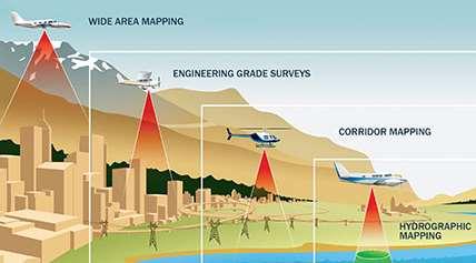
12 LiDAR (Light Detection And Ranging) Mapping Grade Corridor study and planning surveys Asset inventory and management Environmental Surveys Sight distance analysis Earthwork Surveys Urban mapping Coastal zone erosion analysis Survey Grade Mapping grade application + Engineering topographic surveys As-built surveys Structures and bridge clearance surveys Deformation surveys Forensic surveys Engineering Grade Mapping grade application + Survey grade application + 3D Modeling of pavement Transverse and Longitudinal Evenness Rutting Analysis Drainage Analysis


13 Aerial Photography Aircraft DMC II 230 Camera DMC II 230 Camera Number of camera heads 5 PAN : Color Resolution 01:02.6 Frame rate 1.8 sec Color channels R,G,B, NIR Power consumption 350 W Altitude non pressurized 8000 m Resolution per pixel 14 bit MS pixel size 7.2 µm PAN GSD@500m 3.0 cm


14 Aerial Photography UAV / UAS


15 GPR (Ground Penetrating Radar) SYNONYMS Ground Probing Radar GeoRadar Surface Penetrating Radar (SPS) Uses Electro magnetic signals to locate buried objects Many diverse designs and operation methods, but works with transmission of electromagnetic energy (usually a pulse), and the detection of a small amount of that energy reflected from the target The time delay of the reflection contains information on the range of the target.

16 GPR (Ground Penetrating Radar) How Image is produced The round-trip transit time of the pulse emitted by the GPR and its reflection provide range information on the target

17 Time of flight GPR (Ground Penetrating Radar) Image Produced by a point Target Antenna Antenna position
18 Time of flight GPR (Ground Penetrating Radar) Image produced by linear object Antenna position
 Typical Output from")

19 GPR (Ground Penetrating Radar) Typical Output from GPR survey 3D CAD map Multi-channel data visualisation


20 Bathymetric Survey Major Rivers Streams Deep Waters


21 Road Asset Management System (RAMS) Mapping of all Road Furniture and Assets Creation of Database Dashboard for Planning the maintenance Activities
22 Road Asset Management System (RAMS) POINT OBJECTS LINE OBJECTS AREA OBJECTS BOLLARD BRIDGE POINT CABLE BOX CULVERT ELECTRIC POLE LIGHT POLE MILESTONES PLACES OF WORSHIP ROAD LANE MARKING POINT TOWER TREE PLACE OF STAY BRIDGE EXTENTS BUILDING EDGE CURB STONE GUARD RAIL ROAD LANE MARKING TRAFFIC PROTECTION GRID WALL ROAD DRAINAGE BUS STOP CROSSING SECTION DIVIDING STRIP ENTRY AND EXIT GREEN AREA PARKING LANE RAILWAY CROSSING ROAD LANE ROAD LANE MARKING AREA SHOULDER SIDE ROAD SIDEWALK SKY WALK
 Monitoring the IRI")
23 Pavement Management System (PMS) Tool for planning the maintenance and repair of a network of Roadways. Can plan the budgetary projections to optimize the maintenance costs Monitoring the PCI (Pavement Condition Index) Monitoring the IRI (International Roughness Index)


24 Bridge Inspection Detection of Structural Cracks due to wear and tear Bridge safety inspections Conventional Methods Rope Access Inspection. Under Bridge Inspection Vehicle


25 Bridge Inspection UAV / Drone Terrestrial Lidar
26 USE CASES


27 DPR for Pune Ring Road Title: DPR for Ring Road around Pune City for a length of 130 Kms Client: Pune Metropolitan Region Development Authority (PMRDA)
28 Ring Road Salient Features The proposed ring road passes through outskirts of Development plan limit of Pune City. Length of the corridor km Proposed Right of Way 110 m Length of elevated portion 4 km Number of Flyovers/interchanges - 16 Tunnel 3.75 km (Approx.) Major Bridges 6 Nos. ROB 4 Nos. The Ring Road connects major existing traffic generators like Mumbai-Pune Expressway, NH4, NH50, Alandi Road, Pune-Nagar Road, NH 9, Hadpsar- Saswad Road, NH 4, Sinhagad Road, Puad Road, Lawale Road etc.

29 DPR for APCRDA Roads Title: DPR and Detailed Designs for Zonal Development Planning (ZDP) Roads of a length of 24 kms Client: Andhra Pradesh Capital Region Development Authority (APCRDA)
30 DPR for APCRDA Roads Title: DPR and Detailed Designs for Feeder to Inner Ring Road and Zonal Development Planning (ZDP) Roads Client: Andhra Pradesh Capital Region Development Authority (APCRDA) The main objective of consultancy services is to To review and study the proposed road network plans as per ZDP/Master Plan. To decongest the existing stretch of NH-16 between Ramavarapadu and Nidamanuru. Preparation of a Road Development Plan with detailed design of required road and transport Infrastructure. To allow smooth traffic flow without bottle necks To have prioritized public transport system and NMT (non-motorized transport) Corridors.

31 DPR for Widening of 5 urban Roads in Ranchi Title: Feasibility Studies and Preparation of DPR for Widening of 5 Urban Roads in Ranchi City Client: Mecon Limited Description: The objective of this consultancy is to undertake preparation of Concept Report, Inception Report, Draft Detailed Project Report and Final Detailed Project Report of the Project Roads for the purpose of firming up the Authority s requirements in respect of development and construction of the Project Roads and Project Facilities


32 DPR for Widening of 5 urban Roads in Ranchi Latest Technology Used: Mobile Lidar Technology was used for carrying out the survey of all the Road stretches. Optech Lynx SG1 dual head LiDAR system mounted on a vehicle with panoramic cameras for capturing the 3D point cloud data and photographs. The 5 roads were mapped for a corridor width of 60m


33 Road Assets Mapping Title: Client: Road Assets Mapping of Lisbon Highway - Lancaster Speed Map - Scottish Borders Council Description: We used mobile mapping systems based on vehicle mounted video, panoramic cameras and laser scanners as a powerful way of capturing 3D data and imagery.

34 Road Assets Mapping Lancashire Speed Map To capture and model the highway speed restrictions throughout Lancashire. Urban roads 3,329 km / Rural roads 4,683 km Lisbon Highway Asset Mapping Video mapping techniques to capture all road signs, road markings and traffic lights for the entire city of Lisbon. Approximately 1,500 kilometres

35 Street Mapping of Berlin city Objective: Asset data collection of street furniture with in Berlin City Deliverables: Feature Collection, using HLMaP-3D Web based browser with extension of Micro station platform Features captured: driving surfaces, footpaths, bicycle paths, road marking lines, Traffic signs, Traffic lights and other many utility feature Object creation, Streetwise segmentation Pedestrian lines for Blind DGN, ArcGis Shape files (2D/3D)
 Deliverables: Production of River charts and River ENCs for national")

36 Inland Waterways Authority of India Objective: Development of Shoal Analysis and IWN Software for Inland Waterways Authority of India (IWAI) Deliverables: Production of River charts and River ENCs for national waterways (NW1, 2 and 3) Developed IWN Display Software for Navigation Development of Shoal Analysis software for NW1 Sagar Island to Farakka stretch Completed data acquisition in NW4- Godavari River stretch from Rajahmundry to Bhadrachalam
37 Thank You!! Mukesh Varma B Sr. Manager Business Development mukesh.basavaraj@iictechnologies.com Tel: / 47
Mapping a Nation in 3D Singapore s Journey. Bryan Chew Registrar of Titles Assistant Chief Executive Singapore Land Authority
 Mapping a Nation in 3D Singapore s Journey Bryan Chew Registrar of Titles Assistant Chief Executive Singapore Land Authority Singapore Size - 719 sq km Population - 5.5 million Density 7,600/sq km Singapore
VISUALIZING THE SMART CITY 3D SPATIAL INFRASTRUCTURE GEOSMART ASIA- 30 SEP, 2015
 www.aamgroup.com VISUALIZING THE SMART CITY 3D SPATIAL INFRASTRUCTURE GEOSMART ASIA- 30 SEP, 2015 Agenda AAM What is a Smart City? Data Acquisition 3D Modelling Benefits Questions AAM AAM is a Geospatial
Airborne Corridor-Mapping. Planning and documentation of company infrastructure: precise, rapid, and cost effective
 Airborne Corridor-Mapping Planning and documentation of company infrastructure: precise, rapid, and cost effective Technology Airborne Laser-Scanning, digital orthophotos and thermal imaging: one flight
GEOMATICS. Shaping our world. A company of
 GEOMATICS Shaping our world A company of OUR EXPERTISE Geomatics Geomatics plays a mayor role in hydropower, land and water resources, urban development, transport & mobility, renewable energy, and infrastructure
THE USE OF GEOMATICS IN CULTURAL HERITAGE AND ARCHAEOLOGY FOR VARIOUS PURPOSES
 THE USE OF GEOMATICS IN CULTURAL HERITAGE AND ARCHAEOLOGY FOR VARIOUS PURPOSES FEBRUARY 2013 AL BEIDA GEOPLAN CONTENT Company Profile Concept Objectives and Strategies Data Production Methods Data Samples
HKND Group Ltd Grand Canal Project
 HKND Group Ltd Grand Canal Project General Overview of Aerial Survey Project Managua, Nicaragua September 21 st 2015 Presented by: Jeff Elliott Managing Director CSA Global About CSA Global CSA Global
First on the Ground. Geomatics
 First on the Ground Geomatics Surveying and mapping solutions spanning the entire project lifecycle Part art, part science, part technology, the Geomatics profession is constantly evolving. From the very
inovitas be on site with infra3d
 inovitas be on site with infra3d be inspired... Infrastructure has an immense property value and is a prerequisite for a functioning competitive economy. In this context, the modes of transport such as
Existing road transport network of the National Capital Region was examined for the existing connectivity, mobility and accessibility in the study.
 2 Road Network 2.1 Existing Road Network The existing transport network in National Capital Region is radial in nature. It comprises of expressways, national highways, state highways, major district and
GIS = Geographic Information Systems;
 What is GIS GIS = Geographic Information Systems; What Information are we talking about? Information about anything that has a place (e.g. locations of features, address of people) on Earth s surface,
Municipal Act, 2001 Loi de 2001 sur les municipalités
 Municipal Act, 2001 Loi de 2001 sur les municipalités ONTARIO REGULATION 239/02 MINIMUM MAINTENANCE STANDARDS FOR MUNICIPAL HIGHWAYS Consolidation Period: From January 25, 2013 to the e-laws currency date.
Ramani Geosystems. Putting Africa On The Map. Authorized Resellers
 Ramani Geosystems Putting Africa On The Map Authorized Resellers Ramani Profile Started in 1999 Aerial, Land Surveying & Mapping Solutions + 10 Countries in the region + 80 Staff working in projects Asset
Land Administration and Cadastre
 Geomatics play a major role in hydropower, land and water resources and other infrastructure projects. Lahmeyer International s (LI) worldwide projects require a wide range of approaches to the integration
UAV APPLICATIONS IN ENGINEERING. Presented By Wohnrade Civil Engineers, Inc.
 UAV APPLICATIONS IN ENGINEERING Presented By Wohnrade Civil Engineers, Inc. UAV BUSINESS STARTUP March 31, 2015 - Obtained DJI Inspire 1 Unmanned Aerial Vehicle (UAV) FAA requires Certificate of Authorization
ROAD INFORMATION SYSTEM FOR MAINTENANCE MANAGEMENT OF ROAD INFRASTRUCTURE PROJECTS
 ROAD INFORMATION SYSTEM FOR MAINTENANCE MANAGEMENT OF ROAD INFRASTRUCTURE PROJECTS Need for GIS Voluminous/ Manual Data Vs Digital Need for GIS CE - C&B (North) KPWD Secretary Office CE - C&B (South) Dispersed
CORPORATE PROFILE PIONEERING THE FUTURE
 CORPORATE PROFILE PIONEERING THE FUTURE 1984, Developed Utility Data Management System (UDAMS) 1954, First airplane was introduced (DeHavilland Beaver) 2002, "Red Relief Image Map" was invented 1995, The
Geospatial Excellence
 Geospatial Excellence Reality Captured. Certainty Delivered. OUR SERVICES Airborne Survey AAM s diverse range of aerial survey technologies ensures the best tool is deployed to suit the accuracy, timeliness
Exploring the boundaries of your built and natural world. Geomatics
 Exploring the boundaries of your built and natural world Geomatics Before the Luxor brought magic to the Las Vegas strip and before the South LRT extension in Edmonton gave residents a new route to travel,
e-pathai GIS (Electronic Project, Administration, Traffic, Highway Assets and Information management system) in Tamil Nadu Highways
 in Tamil Nadu Highways") e-pathai GIS (Electronic Project, Administration, Traffic, Highway Assets and Information management system) in Tamil Nadu Highways Er.G.Kumar¹, Er.R.Sendel Raj², Er.P.Eshwarmoorthy³, Dr.P.Rajakumar 4
e-pathai GIS (Electronic Project, Administration, Traffic, Highway Assets and Information management system) in Tamil Nadu Highways Er.G.Kumar¹, Er.R.Sendel Raj², Er.P.Eshwarmoorthy³, Dr.P.Rajakumar 4
T: E:
 PAS 128 UTILITY DETECTION AND MAPPING TOPOGRAPHICAL SURVEYS UTILITY RECORD SEARCHES AND DESK TOP STUDY SURFACE WATER DRAINAGE SURVEYS GROUND CLEARANCE SURVEYS MEASURED BUILDING SURVEYS LASER SCANNING UAV
GIS and Remote Sensing
 Spring School Land use and the vulnerability of socio-ecosystems to climate change: remote sensing and modelling techniques GIS and Remote Sensing Katerina Tzavella Project Researcher PhD candidate Technology
Louisiana Transportation Engineering Conference. Monday, February 12, 2007
 Louisiana Transportation Engineering Conference Monday, February 12, 2007 Agenda Project Background Goal of EIS Why Use GIS? What is GIS? How used on this Project Other site selection tools I-69 Corridor
GIS ANALYSIS METHODOLOGY
 GIS ANALYSIS METHODOLOGY No longer the exclusive domain of cartographers, computer-assisted drawing technicians, mainframes, and workstations, geographic information system (GIS) mapping has migrated to
Geospatial SDI Portal for effective Governance of Pune METROPOLIS region
 Geospatial SDI Portal for effective Governance of Pune METROPOLIS region Mr. Praveen Gautam Senior Manager 19 th January 2018 PMRDA Overview Provide a Spatial Framework for the entire region with various
Maricopa County Department of Transportation (MCDOT) GIS Innovations in Transportation Asset Management
 GIS Innovations in Transportation Asset Management") Maricopa County Department of Transportation (MCDOT) GIS Innovations in Transportation Asset Management Presented By Steve Hossack, GIS Database Administrator 2018 ITE/IMSA Spring Conference Maricopa County
Maricopa County Department of Transportation (MCDOT) GIS Innovations in Transportation Asset Management Presented By Steve Hossack, GIS Database Administrator 2018 ITE/IMSA Spring Conference Maricopa County
Presented at the FIG Congress 2018, May 6-11, 2018 in Istanbul, Turkey
 Presented at the FIG Congress 2018, May 6-11, 2018 in Istanbul, Turkey GIS Application in Technical and Environmental Safety of Natural Gas Transmission Pipelines, a Case Study Tuncer OZERBIL GEOGIS GIS
Themes for Geomatics Conference. Geodesy Themes
 Themes for Geomatics Conference Geodesy Themes Geodynamics o Modeling the Deformation of the Earth s Crust o Recent Advances in Geometric Approaches to Deformation Analysis o Monitoring Systems (Sensors
State of Israel Ministry of Housing and Construction Survey of Israel. The Hydrological project case
 State of Israel Ministry of Housing and Construction Survey of Israel The Hydrological project case Survey of Israel Content Introduction To the Survey of Israel The operation assumptions The main responsibilities
MODERNIZATION OF THE MUNICIPAL MAPPING USING HIGH END GNSS SYSTEM AND GIS SOFTWARE
 MODERNIZATION OF THE MUNICIPAL MAPPING USING HIGH END GNSS SYSTEM AND GIS SOFTWARE Mr. R. A. R. Khan Assistant Engineer, Sewerage Utility Management Centre (SUMC) Municipal Corporation Of Greater Mumbai
Using Remote Piloted Aircraft for Seawall Condition Assessment
 Using Remote Piloted Aircraft for Seawall Condition Assessment Moreton Bay Regional Council Shamim Yazdani Senior Engineer - Stormwater Planning DJI Industries Phantom FC-40 remotely-piloted aircraft 1
P R O U D LY C A N A D I A N
 P R O U D LY C A N A D I A N 1.855.423.3185 info@rmegeomatics.com AERIAL SURVEYING IMAGING TERRAIN ANALYSIS WHO WE ARE HSE & REGULATORY CLIENT INDUSTRIES RME Geomatics (formerly NGF Geomatics) was founded
Efficiencies in Data Acquisition and Transformation
 Efficiencies in Data Acquisition and Transformation Andrew LEYZACK Canada Key words: Hydrography, IHO S-57, Nautical Chart SUMMARY For many hydrographic offices, the introduction of electronic nautical
CENTRAL REGION GEOHAZARDS RISK ASSESSMENT SITE INSPECTION FORM
 SITE NUMBER AND NAME C55 H861:02 Slide LEGAL DESCRIPTION NW 14-40-14-W4 CENTRAL REGION GEOHAZARDS RISK ASSESSMENT SITE INSPECTION FORM HIGHWAY & KM NAD 83 COORDINATES N 5811217 E 437291 PREVIOUS INSPECTION
Municipality of Grey Highlands Policy
 Municipality of Grey Highlands Policy Policy Name: Maintenance Standards Plan for Municipal Roadways Policy Number: A09-T-02 Department: Transportation & Environmental Services Authority: Director of Transportation
Evaluation of National Highway by Geographical Information System
 Int. J. Environ. Res., 2(4): 365-370, Autumn 2008 ISSN: 1735-6865 Evaluation of National Highway by Geographical Information System Alam, J. B. *, Nahar, T. and Shaha, B. Civil and Environmental Engineering
Public Open House Meeting Thursday, February 22, Broken Arrow to Tulsa Mass Transit Feasibility Study
 Public Open House Meeting Thursday, February 22, 2007 Broken Arrow to Tulsa Mass Transit Feasibility Study Meeting Agenda Welcome Where we Are What we ve Learned Corridor Study Map Stations (Commuter Rail
Aerial Survey of Coffee Estates
 Aerial Survey of Coffee Estates Why get an Aerial Survey of your Coffee Estate done? Aerial surveying produces high resolution and highly accurate image data about your coffee estate. This data can be
Implementation of GISystems in the Land Acquisition Process and Road Maintenance. Immaculate Katutsi Uganda National Roads Authority
 Implementation of GISystems in the Land Acquisition Process and Road Maintenance Immaculate Katutsi Uganda National Roads Authority Stage 1 Stage 2 Stage 3 2 The Road construction process/ Project flow
To achieve these Global Sustainable Development Goals, geospatial data are crucial.
 To achieve these Global Sustainable Development Goals, geospatial data are crucial. 2 http://www.globalgoals.org/ HIGH INCOME NATION SUSTAINABLE GROWTH SOCIALLY INCLUSIVE 3 http://etp.pemandu.gov.my/ 12
Detection of Slope Instability using 3D LiDAR Modelling
 Detection of Slope Instability using 3D LiDAR Modelling Duffell CG 1, Rudrum DM 2 and Willis MR 3 1 Technical Adviser (Geotechnics), Highways Agency. City Tower, Piccadilly Plaza, Manchester, M1 4BE, United
CENSUS MAPPING WITH GIS IN NAMIBIA. BY Mrs. Ottilie Mwazi Central Bureau of Statistics Tel: October 2007
 CENSUS MAPPING WITH GIS IN NAMIBIA BY Mrs. Ottilie Mwazi Central Bureau of Statistics E-mail: omwazi@npc.gov.na Tel: + 264 61 283 4060 October 2007 Content of Presentation HISTORICAL BACKGROUND OF CENSUS
Using Mobile Lidar to Survey Railway Infrastructure. Lynx Mobile Mapper
 Using Mobile Lidar to Survey Railway Infrastructure. Lynx Mobile Mapper Daina MORGAN, Canada Key words: Lidar, Mobile Mapping, Railway, 3D. Summary This project proved that the Lynx Mobile Mapper can quickly
Transforming the Maricopa County Department of Transportation (MCDOT) GIS-based Transportation Asset Inventory System June 30, 2016
 GIS-based Transportation Asset Inventory System June 30, 2016") Transforming the Maricopa County Department of Transportation (MCDOT) GIS-based Transportation Asset Inventory System June 30, 2016 Presented By Steve Hossack, GIS Database Administrator 2016 Esri User
Transforming the Maricopa County Department of Transportation (MCDOT) GIS-based Transportation Asset Inventory System June 30, 2016 Presented By Steve Hossack, GIS Database Administrator 2016 Esri User
Fugro Geospatial: Turning Spatial Data into Knowledge
 Fugro Geospatial: Turning Spatial Data into Knowledge 2016 Fugro Geospatial, GIS and Consultants Locations Variety of Collection Platforms Traditional Mapping Traditional Mapping Imagery Photogrammetric
"GIS-Sofia" Ltd. geospatial data integration in SOFCAR geographic information system and providing services March 2018, Sofia
 "GIS-Sofia" Ltd. geospatial data integration in SOFCAR geographic information system and providing services Geographical Information System Sofia " Ltd....the beginning... Established in 1999, as a Sofia
1. PROJECT BACKGROUND. July 18, Alberta Infrastructure & Transportation Central Region #401, Street Red Deer, Alberta T4N 6K8
 July 18, 2005 Alberta Infrastructure & Transportation Central Region #401, 4902 51 Street Red Deer, Alberta T4N 6K8 Mr. Alain Momedi, P.Eng. Project Engineer Dear Mr. Momedi: H11:04 km 11.1 Erosion along
Eyes in the Sky & Data Analysis.
 Eyes in the Sky & Data Analysis How can we collect Information about Earth Climbing up Trees & Mountains Gathering Food Self Protection Understanding Surroundings By Travelling Collected Information Converted
GIS Geographical Information Systems. GIS Management
 GIS Geographical Information Systems GIS Management Difficulties on establishing a GIS Funding GIS Determining Project Standards Data Gathering Map Development Recruiting GIS Professionals Educating Staff
COUNCIL POLICY MANUAL
 COUNCIL POLICY MANUAL SECTION: PUBLIC WORKS SUBJECT: SNOW & ICE CONTROL POLICY 2012/2013 GOAL: Pages: 1 of 10 Approval Date: Dec. 3, 2012 Res. # 1001/2012 To annually identify the winter maintenance costs
CityGML and the Streets of New York A Proposal for Detailed Street Space Modeling
 LEONHARD OBERMEYER CENTER TUM CENTER OF DIGITAL METHODS FOR THE BUILT ENVIRONMENT CityGML and the Streets of New York A Proposal for Detailed Street Space Modeling Christof Beil & Thomas H. Kolbe Chair
STEREO ANALYST FOR ERDAS IMAGINE Stereo Feature Collection for the GIS Professional
 STEREO ANALYST FOR ERDAS IMAGINE Stereo Feature Collection for the GIS Professional STEREO ANALYST FOR ERDAS IMAGINE Has Your GIS Gone Flat? Hexagon Geospatial takes three-dimensional geographic imaging
GIS-based Smart Campus System using 3D Modeling
 GIS-based Smart Campus System using 3D Modeling Smita Sengupta GISE Advance Research Lab. IIT Bombay, Powai Mumbai 400 076, India smitas@cse.iitb.ac.in Concept of Smart Campus System Overview of IITB Campus
Appendix C Benchmarking Cost Estimates
 REPORT Appendix C Benchmarking Cost Estimates C-1 Table C-1 Permits, Notifications & Location Services Notes: Costs associated with delays in construction have not been included in this estimate OneCall
Linear Referencing Systems (LRS) Support for Municipal Asset Management Systems
 Support for Municipal Asset Management Systems") Linear Referencing Systems (LRS) Support for Municipal Asset Management Systems Esri Canada Infrastructure Asset Management Leadership Forum November 1, 2017 Toronto, ON David Loukes, P. Eng., FEC Andy
Linear Referencing Systems (LRS) Support for Municipal Asset Management Systems Esri Canada Infrastructure Asset Management Leadership Forum November 1, 2017 Toronto, ON David Loukes, P. Eng., FEC Andy
Policy Title: Snow Removal & Ice Control Policy #: PW
 Village of Fruitvale Corporate Policy Manual Policy Title: Snow Removal & Ice Control Policy #: PW-2012-01 Section: PUBLIC WORKS Initially Approved: 2012 06 04 Last Reviewed: 2013 05 06 Council Approval:
Non-Destructive Pavement Evaluation to Assess Flood Damage in The City of Calgary
 Non-Destructive Pavement Evaluation to Assess Flood Damage in The City of Calgary Venkat Lakkavalli P. Eng., M. Sc. The City of Calgary Alberta, Canada Presented at TAC 2014, Montreal (Karim, M et al.
Google Maps and Beyond
 Google Maps and Beyond Aaron Paul First American Title apaul@firstam.com 2015 APRA Symposium Association of Professional Reserve Analysts May 2 nd, 2015 Google Maps and Beyond - Overview Business case
The sensitivity of repeated profile measurements to pavement unevenness and surface conditions
 CONTROL ENGINEERING The sensitivity of repeated profile measurements to pavement unevenness and surface conditions ENEA SOGNO and MICHELE MORI Prague, 20.10.2016 Summary The company Business sectors Accreditation
Imagery and the Location-enabled Platform in State and Local Government
 Imagery and the Location-enabled Platform in State and Local Government Fred Limp, Director, CAST Jim Farley, Vice President, Leica Geosystems Oracle Spatial Users Group Denver, March 10, 2005 TM TM Discussion
Stop 1: Marmot Dam Stop 1: Marmot Dam
 Stop 1: Marmot Dam Stop 1: Marmot Dam Following the removal of Marmot Dam in 2007, the fate of the reservoir sediments has been monitored through a series of surveys and sediment transport measurements.
Martin MENSA, Eli SABLAH, Emmanuel AMAMOO-OTCHERE and Foster MENSAH, Ghana. Key words: Feeder Roads Condition Survey, Database Development
 Digital Mapping and GIS-Driven Feeder Road Network Database Management System for Road Project Planning and Implementation Monitoring in the Feeder Road Sector Martin MENSA, Eli SABLAH, Emmanuel AMAMOO-OTCHERE
Geotechnical Data for Transportation Infrastructure. Tim Spink, Mott MacDonald
 Geotechnical Data for Transportation Infrastructure Tim Spink, Mott MacDonald The transportation geotechnical asset Foundations Tunnels Road & track bed Earthworks Also supports: communication lines noise
Use of remote sensing for proactive management of geotechnical assets on the strategic road network in England
 Use of remote sensing for proactive management of geotechnical assets on the strategic road network in England Áine Ní Bhreasail Ground Related Risk to Transportation Infrastructure October 26 th -27 th
ArcGIS Pro 3D Workflows. Zena Pelletier
 ArcGIS Pro 3D Workflows Zena Pelletier 3D as a GIS capability Core part of the platform Desktop Web Device Combine 2D and 3D in the same web GIS architecture Reuse dynamic services across clients Securely
Case Histories and Practical Examples
 SUMMER SCHOOL SIIV 2012 - ROAD SAFETY MANAGEMENT Theoretical principles and practical application in the framework of the European Directive 2008/96/CE Catania 24-28 September 2012 Case Histories and Practical
COMPANY PROFILE. For PHOTOGRAMMETRY, LiDAR, BIM, UAV, GIS and SURVEYING SOLUTIONS. Submitted by MARVEL GEOSPATIAL SOLUTIONS PVT.LTD.
 COMPANY PROFILE For PHOTOGRAMMETRY, LiDAR, BIM, UAV, GIS and SURVEYING SOLUTIONS Submitted by MARVEL GEOSPATIAL SOLUTIONS PVT.LTD. Table of Contents 1. ABOUT US... 3 1.1 MISSION/VISION... 4 2. SERVICES
GIS-T 2010 Building a Successful Geospatial Data Sharing Framework: A Ohio DOT Success Story
 GIS-T 2010 Building a Successful Geospatial Data Sharing Framework: A Ohio DOT Success Story ODOT District 2 GIS John Puente District 1 GIS Coordinator\ Planning Administrator 2 Interoperability 3 District
Office of Enterprise Technology
 Office of Enterprise Technology Transforming the Maricopa Department of Transportation (MCDOT) GIS-based Transportation Asset Inventory System January 21, 2016 Presented By Steve Hossack, GIS Database
2 nd Semester. Core Courses. C 2.1 City and Metropolitan Planning. Module 1: Urban Structure and Growth Implications
 2 nd Semester Core Courses C 2.1 City and Metropolitan Planning Module 1: Urban Structure and Growth Implications Growth of cities; cities as engine of growth; urban sprawl; land value, economic attributes
CITY OF NEW LONDON WINTER ROAD & SIDEWALK MAINTENANCE POLICY
 CITY OF NEW LONDON WINTER ROAD & SIDEWALK MAINTENANCE POLICY GENERAL The purpose of this policy is to set up acceptable procedures and policies for the winter maintenance of public areas in the City of
An Industry Perspective. Bryn Fosburgh Vice President Trimble
 An Industry Perspective Bryn Fosburgh Vice President Trimble Who are we? Professionals & Consultants Geospatial Professionals working at or with: AEC Consultants Transportation Departments Construction
Geospatial Big Data Analytics for Road Network Safety Management
 Proceedings of the 2018 World Transport Convention Beijing, China, June 18-21, 2018 Geospatial Big Data Analytics for Road Network Safety Management ABSTRACT Wei Liu GHD Level 1, 103 Tristram Street, Hamilton,
Cutting Edge Engineering for Modern Geospatial Systems Rear Admiral Dr. S Kulshrestha, retd
 Cutting Edge Engineering for Modern Geospatial Systems Rear Admiral Dr. S Kulshrestha, retd 11 Jun 2015 GeoIntelligence Asia 2015 The technology would become so pervasive that it becomes a part of you
Using Public Information and Graphics Software in Graduate Highway Safety Research at Worcester Polytechnic Institute
 Using Public Information and Graphics Software in Graduate Highway Safety Research at Worcester Polytechnic Institute C.E. Conron, C. Silvestri, A. Gagne, M.H. Ray Department of Civil and Environmental
Auckland Transport. Auckland Council. Statement of Evidence of Simon John Ferneyhough
 Under the Resource Management Act 1991 In the matter of Notices of Requirement to enable the construction, operation and maintenance of the City Rail Link Between Auckland Transport Requiring Authority
NCTCOG Regional GIS Meeting 6-Years and Going Strong. May 15, 2018 hosted by: Tarrant County
 NCTCOG Regional GIS Meeting 6-Years and Going Strong May 15, 2018 hosted by: Tarrant County Woolpert at a Glance 1911 Founded in Dayton, Ohio 25+ Offices across the nation 800+ Global employees 25+ OFFICES
GEOMATICS SURVEYING AND MAPPING EXPERTS FOR OVER 35 YEARS
 GEOMATICS SURVEYING AND MAPPING EXPERTS FOR OVER 35 YEARS 2 GEOMATICS AND SURVEYING SOLUTIONS SPANNING THE ENTIRE PROJECT LIFECYCLE 1,000+ 250+ 24 Surveying professionals Active field crews Geomatics offices
Global UAV-based solutions for the industry and agriculture.
 Global UAV-based solutions for the industry and agriculture. Remote sensing of vegetation from drones (UAS). The example of the Trimble Unmanned Aerial Solution Emmanuel de Maistre, co-founder & CEO demaistre@redbird.fr
Sewer Lateral Mapping: An Automated Approach
 Sewer Lateral Mapping: An Automated Approach MSGIC 2016 Fall Quarterly Meeting David Thaler, GISP david.thaler@ebaengineering.com EBA Engineering, Inc. 6100 Chevy Chase Drive Suite 200 Laurel, MD 20707-2917
Modeling Great Britain s Flood Defenses. Flood Defense in Great Britain. By Dr. Yizhong Qu
 Modeling Great Britain s Flood Defenses AIRCurrents Editor s note: AIR launched its Inland Flood Model for Great Britain in December 2008. The hazard module captures the physical processes of rainfall-runoff
SOLUTIONS ADVANCED GIS. TekMindz are developing innovative solutions that integrate geographic information with niche business applications.
 ADVANCED GIS SOLUTIONS TekMindz are developing innovative solutions that integrate geographic information with niche business applications. TEK INDZ TM GIS Services Overview At the leading edge of geospatial
Local EPM Implementation Process in 5 stages
 Local PM Implementation Process in 5 stages 3. Working groups 1. City nvironmental Profile/ Outlook 5. Consolidation & Institutionalisation 4. Strategy & Action plans 2. City Consultation Urban nvironmental
A Broad View of Geospatial Technology & Systems
 A Broad View of Geospatial Technology & Systems Pete Large Vice President, Trimble On the shoulders of giants 1 Since their time, our ability to generate geospatial information has grown exponentially
CVS Derwood. Local Area Transportation Review
 CVS Derwood Montgomery County, Maryland May 27, 2016 Local Area Transportation Review Prepared for: JC Bar Properties, Inc. Steve Fleming, PE 415 Fallowfield Road, Suite 301 Camp Hill, Pennsylvania 17011
Susan Clark NRS 509 Nov. 29, 2005
 Susan Clark NRS 509 Nov. 29, 2005 The original intent of this project was to look at the role of GIS in the inventory of bicycle and pedestrian facilities. The research, however, indicates a different
SURVEYING Chapter 1 Introduction
 PHILADELPHIA UNIVERSITY Faculty of Engineering. Department of Civil Engineering. SURVEYING Chapter 1 Introduction Surveying : the art or science of measuring and representing natural and artificial features
City of Saginaw Right of Way Division Snow and Ice Removal Policy January 18, 2016
 Snow and Ice Removal Policy January 18, 2016 It is the policy of the to provide snowplowing and ice removal services in order to: Provide safe traveling conditions for motorists and pedestrians Assist
Study on Shandong Expressway Network Planning Based on Highway Transportation System
 Study on Shandong Expressway Network Planning Based on Highway Transportation System Fei Peng a, Yimeng Wang b and Chengjun Shi c School of Automobile, Changan University, Xian 71000, China; apengfei0799@163.com,
Introduction of PASCO Corporation
 Technical Seminar Reference Frame in Practice, Introduction of PASCO Corporation MASAKI MIYASAKA Sponsors: Page 1 Company Profile Establishment: October 27, 1953 Head office: Meguro-ku, Tokyo (57 offices
MID-TERM CONFERENCE CREST
 MID-TERM CONFERENCE CREST 23 November 2017 Innovation in Coastal Monitoring Alain De Wulf (Ugent, Geography Dept.) Innovation in coastal monitoring Outline Why? How? What (tools do we use to assess)? Conclusion
FY 2018 Ten Year Capital Plan Review Project List
 FY 2018 Ten Year Capital Plan Review Project List Program Category FY2018 FY2019 FY2020 FY2021 FY2022 FY2023 FY2024 FY2025 FY2026 FY2027 Highway Roadway/Safety 100,950,000 128,431,766 125,896,635 91,153,571
Data Conversion to I3S for 3D Modeling from CityGML. Christian Dahmen (con terra GmbH) Satish Sankaran (Esri)
 Satish Sankaran (Esri)") Data Conversion to I3S for 3D Modeling from CityGML Christian Dahmen (con terra GmbH) Satish Sankaran (Esri) 3D Across the ArcGIS Platform Manage Multiscale 3D Models 3D Geodesign ArcGIS for 3D Cities
Data Conversion to I3S for 3D Modeling from CityGML Christian Dahmen (con terra GmbH) Satish Sankaran (Esri) 3D Across the ArcGIS Platform Manage Multiscale 3D Models 3D Geodesign ArcGIS for 3D Cities
Executive Summary Name: Company: Name of Project: Awards Result:
 Executive Summary Name: Dwayne Honor Company: Bundaberg Regional Council Name of Project: Streamlining Workflows The Integration of 12d, 12d Field and GIS Awards Result: Third Place (Tied) For many years
Aerial Photograph-Based Pavement Surface Distress Detection and Evaluation
 Aerial Photograph-Based Pavement Surface Distress Detection and Evaluation César Hernández Gracia Antonio Sahuquillo Piñero AF2913-Road Construction and Maintenance Table of Contents 1. Introduction 2.
Application of high-resolution (10 m) DEM on Flood Disaster in 3D-GIS
 DEM on Flood Disaster in 3D-GIS") Risk Analysis V: Simulation and Hazard Mitigation 263 Application of high-resolution (10 m) DEM on Flood Disaster in 3D-GIS M. Mori Department of Information and Computer Science, Kinki University, Japan
Risk Analysis V: Simulation and Hazard Mitigation 263 Application of high-resolution (10 m) DEM on Flood Disaster in 3D-GIS M. Mori Department of Information and Computer Science, Kinki University, Japan
Developing a Campus-wide Base Map for Planning, Design and Construction. June 21, 2007
 Developing a Campus-wide Base Map for Planning, Design and Construction June 21, 2007 Presenters Berent Pippert UCR Project Manager Capital and Physical Planning Academic Planning and Budget 951-827-2431
1994: JV formed for civil engineering consultancy COWI/KX A/s, Denmark(51%) IFU, Denmark (24% ) IL&FS Infrastructure Dev Corp, India(25%)
 IFU, Denmark (24% ) IL&FS Infrastructure Dev Corp, India(25%)") Company Profile 1994: JV formed for civil engineering consultancy COWI/KX A/s, Denmark(51%) IFU, Denmark (24% ) IL&FS Infrastructure Dev Corp, India(25%) 1998: Start of mapping as a new segment of Business.
Company Profile 1994: JV formed for civil engineering consultancy COWI/KX A/s, Denmark(51%) IFU, Denmark (24% ) IL&FS Infrastructure Dev Corp, India(25%) 1998: Start of mapping as a new segment of Business.
PW 001 SNOW REMOVAL AND SANDING FOR ROADWAYS AND SIDEWALKS October 6, 2014 (#223-14) Original October 19, 2015; October 15, 2018 Public Works
 Original October 19, 2015; October 15, 2018 Public Works") Policy Statement: The Village of Kitscoty will provide snow and ice control on municipal streets and sidewalks according to determined priorities. Purpose: To provide direction and information to employees
Policy Statement: The Village of Kitscoty will provide snow and ice control on municipal streets and sidewalks according to determined priorities. Purpose: To provide direction and information to employees
GIS Application in Technical and Environmental Safety of Natural Gas Transmission Pipelines, a Case Study
 GIS Application in Technical and Environmental Safety of Natural Gas Transmission Pipelines, a Case Study Tuncer OZERBIL, Engin PEKEL, Dilvin Ceneli TUGRUL, Cihan SEZGIN and Osman SELCUK, Turkey Key words:
Flood Mapping Michael Durnin October 9 th
 Michael Durnin October 9 th 2014 Leading Surveyors Company Profile Est. 1983 Celebrating 30 Years in Business Six Offices in UK & Ireland Over 30 Specialised Survey Services ISO 9001:2008 Registered Over