Census Urban Area Comparisons, 2000 to 2010
|
|
|
- Marylou Bishop
- 6 years ago
- Views:
Transcription


1 THE HONORABLE ROGERS Mayor ANDERSON, Karl Dean, CHAIRMAN Chairman Census Urban Area Comparisons, 2000 to 2010 TCC May 2, 2012

2 MPOs/RPOs in Tennessee

3 Regional Geographies in Middle TN Nashville MPO Clarksville MPO Mayors Caucus Metropolitan Statistical Area (MSA)
4 Census Urban Areas Two Types of Urban Areas defined by Census (1880/1910) 50,000 or more people = Urbanized Area (UZA) (1950) 2,500 to <50,000 = Urban Cluster (UC) (2000) All other areas are considered Rural Why does the Census Bureau Delineate Urban Areas? To provide statistical information about urban and rural areas for use by researchers and government agencies Used by OMB to define the core of MSAs Factors in Delineating Areas Minimum population density Minimum population residing outside of group quarters Airports with minimum number of passengers Presence of other minimum nonresidential territory
5 2000 Census Urban Areas
6 2010 Census Urban Areas


7 2000 vs Census Urban Areas

8 2000 Census Urban Areas
9 2010 Census Urban Areas


10 2000 vs Census Urban Areas
11 Key Changes from Census 2000 Nashville Davidson Urbanized Area Merged with the old White House Urban Cluster Taken on former Murfreesboro UZA areas around LaVergne and Smyrna Redrawn to exclude the Springfield area Now includes portions of six counties Murfreesboro Urbanized Area Redrawn to exclude the areas around LaVergne and Smyrna White House Urban Cluster Merged with the Nashville Davidson UZA Springfield Urban Cluster Delineated from the Nashville Davidson UZA Spring Hill Urban Cluster Grew substantially to become third largest UA in MPO area
12 Implications of Changes Urban Areas are basis of Federal Formula Funds FHWA Surface Transportation Program (STP) FTA Urbanized Area Formula Program (5307) FTA JARC (5316) and New Freedom (5317) Programs FHWA & FTA Metropolitan Planning Funds Many others. Urban Areas over 50,000 required to be part of an MPO to participate in the federal transportation program Urban Areas over 200,000 are defined as a Transportation Management Agency(TMA) Federally defined suballocation amounts Additional planning requirements Cannot use federal funds to operate transit services
13 Next Steps No appeal process for Census definitions Evaluate changes to determine if new areas are required to be a part of an MPO Work with TDOT to define the Federal Aid Urban Area boundary for the purposes of defining the federal functional classification system Evaluate other factors that affect the MPO planning area and board representation
14 What Determines the MPO Planning Area
15 MPO Planning Area Considerations US Census designations for Urban Areas over 50,000 in population Areas adjacent to an existing urbanized area that is expected to urbanize over the next 20 years Commuter sheds/ Travel patterns Alignment/ Coordination with regional economic development efforts Conformity with national air quality standards
16 Urbanizing Areas


17 Market and Policy Driven Forecasting Environmental Constraints Land Use Policy Suitability Analysis Growth Policy

 1965 750,000 Properties affected by")
18 Development Pattern, Population ,600, ,450,000 (In 2035, the Nashville region will be about the size of the Denver region today) ,000 Properties affected by development
19 Commuter Sheds


20 Transportation is Regional Issue WORK in Downtown Nashville, LIVE in..


21 Transportation is Regional Issue WORK in Franklin/ Cool Springs, LIVE in..


22 Transportation is Regional Issue LIVE in Franklin/ Cool Springs, WORK in..

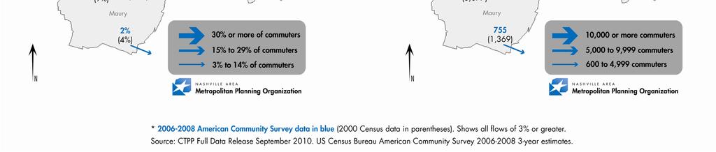
23 2000/2010 Census Journey-to-Work
24 Economic Development


25 Partnership 2020 Partnership 2020 program is the region s leading economic development initiative for recruiting new businesses to Nashville, including relocating firms and local expansions. The program originated as Partnership 2000 in 1990.


26 Discussion
27 Discussion What geographic region do you think the MPO should represent and why? What are the advantages and disadvantages of MPO planning area expansion? What process should we establish for inviting adjacent areas to join the MPO? How do we ensure adequate coordination in the meantime?
Rural Pennsylvania: Where Is It Anyway? A Compendium of the Definitions of Rural and Rationale for Their Use
 Rural Pennsylvania: Where Is It Anyway? A Compendium of the Definitions of Rural and Rationale for Their Use Pennsylvania Office of Rural Health 310 Nursing Sciences Building University Park, PA 16802
Rural Alabama. Jennifer Zanoni. Geography Division U.S. Census Bureau. Alabama State Data Center 2018 Data Conference Tuscaloosa, Alabama
 Rural Alabama Jennifer Zanoni Geography Division U.S. Census Bureau Alabama State Data Center 2018 Data Conference Tuscaloosa, Alabama May 17, 2018 Agenda Census Geography Urban/Rural Definitions County-based
Updating the Urban Boundary and Functional Classification of New Jersey Roadways using 2010 Census data
 Updating the Urban Boundary and Functional Classification of New Jersey Roadways using 2010 Census data By: Glenn Locke, GISP, PMP 1 GIS-T May, 2013 Presentation Overview Purpose of Project Methodology
Frequently Asked Questions
 What is the Regional Transit Engagement Series? As one of the fastest growing regions in the country, there is recognition that long-term transit planning efforts should be accelerated if we are to remain
The Census, Urbanized Areas, and Your MPO/RPO
 The Census, Urbanized Areas, and Your MPO/RPO Alex Bond, AICP NADO Rural Transportation Peer Learning Conference August 25, 2011 1 Issues to Discuss Census background Definitions of Census geographies
US Census Bureau Geographic Entities and Concepts. Geography Division
 US Census Bureau Geographic Entities and Concepts Geography Division Geographic Concepts Addresses vs. Geographic features and entities Legal/Administrative vs. Statistical Nesting relationships (or the
The Rural Health Workforce. Policy Brief Series. Data and Issues for Policymakers in: Washington Wyoming Alaska Montana Idaho
 The Health Workforce Data and Issues for Policymakers in: Washington Wyoming Alaska Montana Idaho Policy Brief Series ISSUE #1: THE RURAL HEALTH WORKFORCE: CHALLENGES AND OPPORTUNITIES ISSUE #2: THE RURAL
Transit Development Planning: Flagler County Needs Assessment & Implementation Program INTERGOVERNMENTAL MEETING OF FLAGLER COUNTY APRIL 13, 2010
 Transit Development Planning: nty Needs Assessment & Implementation Program INTERGOVERNMENTAL MEETING OF FLAGLER COUNTY APRIL 13, 2010 Rob Gregg & Justin Begley, Center for Urban Transportation Research
OREGON POPULATION FORECAST PROGRAM
 OREGON POPULATION FORECAST PROGRAM PROGRAM OVERVIEW BACKGROUND Beginning in 1973 with the passage of Senate Bill (SB) 100, Oregon s growth management system has relied on population forecasts as the primary
Passenger Transportation Networks & Urbanization Level: A Comparison of Classification Schemes
 Pyrialakou, Nlenanya, Gkritza 0 0 Passenger Transportation Networks & Urbanization Level: A Comparison of Classification Schemes V. Dimitra Pyrialakou (Corresponding author) Graduate Research Assistant,
HORIZON 2030: Land Use & Transportation November 2005
 PROJECTS Land Use An important component of the Horizon transportation planning process involved reviewing the area s comprehensive land use plans to ensure consistency between them and the longrange transportation
Regional Transit Development Plan Strategic Corridors Analysis. Employment Access and Commuting Patterns Analysis. (Draft)
") Regional Transit Development Plan Strategic Corridors Analysis Employment Access and Commuting Patterns Analysis (Draft) April 2010 Contents 1.0 INTRODUCTION... 4 1.1 Overview and Data Sources... 4 1.2
Regional Transit Development Plan Strategic Corridors Analysis Employment Access and Commuting Patterns Analysis (Draft) April 2010 Contents 1.0 INTRODUCTION... 4 1.1 Overview and Data Sources... 4 1.2
Tracey Farrigan Research Geographer USDA-Economic Research Service
 Rural Poverty Symposium Federal Reserve Bank of Atlanta December 2-3, 2013 Tracey Farrigan Research Geographer USDA-Economic Research Service Justification Increasing demand for sub-county analysis Policy
Bureau of Economic and Business Research May 29, Measuring Population Density for Counties in Florida
 Bureau of Economic and Business Research May 29, 2015 Measuring Population Density for Counties in Florida By: Stefan Rayer, PhD; Ying Wang, PhD https://www.bebr.ufl.edu/content/measuring-population-density-counties-florida
Assessing the Vulnerability of Tennessee Transportation Assets to Extreme Weather
 Assessing the Vulnerability of Tennessee Transportation Assets to Extreme Weather Dr. Mark Abkowitz, Vanderbilt University 8 th Annual Intermodal Conference Memphis TN October 7, 2014 Requires states to
Expanding the GSATS Model Area into
 Appendix A Expanding the GSATS Model Area into North Carolina Jluy, 2011 Table of Contents LONG-RANGE TRANSPORTATION PLAN UPDATE 1. Introduction... 1 1.1 Background... 1 1.2 Existing Northern Extent of
FHWA Planning Data Resources: Census Data Planning Products (CTPP) HEPGIS Interactive Mapping Portal
 HEPGIS Interactive Mapping Portal") FHWA Planning Data Resources: Census Data Planning Products (CTPP) HEPGIS Interactive Mapping Portal Jeremy Raw, P.E. FHWA, Office of Planning, Systems Planning and Analysis August 2017 Outline Census
FHWA Planning Data Resources: Census Data Planning Products (CTPP) HEPGIS Interactive Mapping Portal Jeremy Raw, P.E. FHWA, Office of Planning, Systems Planning and Analysis August 2017 Outline Census
Key Issue 1: Why Do Services Cluster Downtown?
 Key Issue 1: Why Do Services Cluster Downtown? Pages 460-465 ***Always keep your key term packet out whenever you take notes from Rubenstein. As the terms come up in the text, think through the significance
Census Transportation Planning Products (CTPP)
") Census Transportation Planning Products (CTPP) Penelope Weinberger CTPP Program Manager - AASHTO September 15, 2010 1 What is the CTPP Program Today? The CTPP is an umbrella program of data products, custom
Census Transportation Planning Products (CTPP) Penelope Weinberger CTPP Program Manager - AASHTO September 15, 2010 1 What is the CTPP Program Today? The CTPP is an umbrella program of data products, custom
DRAFT RURAL-URBAN POPULATION CHANGE IN PUERTO RICO, 1990 TO 2000
 DRAFT RURAL-URBAN POPULATION CHANGE IN PUERTO RICO, 1990 TO 2000 Mei-Ling Freeman Geographic Standards and Criteria Branch Geography Division US Census Bureau For presentation at the Western Regional Science
Key Issue 1: Why Do Services Cluster Downtown?
 Key Issue 1: Why Do Services Cluster Downtown? Pages 460-465 1. Define the term CBD in one word. 2. List four characteristics of a typical CBD. Using your knowledge of services from chapter 12, define
Whither Regionalism: The Salience of Megaregional Geographies for Inter-Metropolitan Planning and Policy Making
 Whither Regionalism: The Salience of Megaregional Geographies for Inter-Metropolitan Planning and Policy Making Michael Oden, Ph.D Community and Regional Planning Program University of Texas at Austin
THE MOST TRANSPARENT TREND in metropolitan areas is the decentralization of jobs and housing into
 AS JOBS SPRAWL, WHITHER THE COMMUTE? BY RANDALL CRANE AND DANIEL G. CHATMAN THE MOST TRANSPARENT TREND in metropolitan areas is the decentralization of jobs and housing into the suburbs and beyond. Scholars
Census Geography, Geographic Standards, and Geographic Information
 Census Geography, Geographic Standards, and Geographic Information Michael Ratcliffe Geography Division US Census Bureau New Mexico State Data Center Data Users Conference November 19, 2015 Today s Presentation
Date: June 19, 2013 Meeting Date: July 5, Consideration of the City of Vancouver s Regional Context Statement
 Section E 1.5 To: From: Regional Planning and Agriculture Committee Lee-Ann Garnett, Senior Regional Planner Planning, Policy and Environment Department Date: June 19, 2013 Meeting Date: July 5, 2013 Subject:
Do the Causes of Poverty Vary by Neighborhood Type?
 Do the Causes of Poverty Vary by Neighborhood Type? Suburbs and the 2010 Census Conference Uday Kandula 1 and Brian Mikelbank 2 1 Ph.D. Candidate, Maxine Levin College of Urban Affairs Cleveland State
DEVELOPING DECISION SUPPORT TOOLS FOR THE IMPLEMENTATION OF BICYCLE AND PEDESTRIAN SAFETY STRATEGIES
 DEVELOPING DECISION SUPPORT TOOLS FOR THE IMPLEMENTATION OF BICYCLE AND PEDESTRIAN SAFETY STRATEGIES Deo Chimba, PhD., P.E., PTOE Associate Professor Civil Engineering Department Tennessee State University
Environmental Analysis, Chapter 4 Consequences, and Mitigation
 Environmental Analysis, Chapter 4 4.17 Environmental Justice This section summarizes the potential impacts described in Chapter 3, Transportation Impacts and Mitigation, and other sections of Chapter 4,
Visualization of Commuter Flow Using CTPP Data and GIS
 Visualization of Commuter Flow Using CTPP Data and GIS Research & Analysis Department Southern California Association of Governments 2015 ESRI User Conference l July 23, 2015 l San Diego, CA Jung Seo,
c. What is the most distinctive above ground result of high land costs and intensive land use? i. Describe the vertical geography of a skyscraper?
 AP Human Geography Unit 7b Guided Reading: Urban Patterns and Social Issues Mr. Stepek Key Issue #1: Why Do Services Cluster Downtown? (Rubenstein p 404 410) 1. What is the CBD? What does it contain and
Use of US Census Data for Transportation Modeling and Planning
 Use of US Census Data for Transportation Modeling and Planning Yongqiang Wu, P.E. CTS Engineering, Inc. Southeast Florida FSUTMS User Group Meeting September 14, 2018 Outline Overview of Census Products
Study Overview. the nassau hub study. The Nassau Hub
 Livable Communities through Sustainable Transportation the nassau hub study AlternativeS analysis / environmental impact statement The Nassau Hub Study Overview Nassau County has initiated the preparation
DeKalb Sycamore Area Transportation Study (DSATS) Socioeconomic Forecast Methodology
 Socioeconomic Forecast Methodology") DeKalb Sycamore Area Transportation Study (DSATS) Socioeconomic Forecast Methodology Submitted by: April 12, 2015 Table of Contents 1. Introduction 1 1.1 Background 1 1.2 Study Area 2 2. Regional Socioeconomic
DeKalb Sycamore Area Transportation Study (DSATS) Socioeconomic Forecast Methodology Submitted by: April 12, 2015 Table of Contents 1. Introduction 1 1.1 Background 1 1.2 Study Area 2 2. Regional Socioeconomic
An Introduction to China and US Map Library. Shuming Bao Spatial Data Center & China Data Center University of Michigan
 An Introduction to China and US Map Library Shuming Bao Spatial Data Center & China Data Center University of Michigan Current Spatial Data Services http://chinadataonline.org China Geo-Explorer http://chinageoexplorer.org
Economic and Social Urban Indicators: A Spatial Decision Support System for Chicago Area Transportation Planning
 Economic and Social Urban Indicators: A Spatial Decision Support System for Chicago Area Transportation Planning Piyushimita Thakuriah (Vonu), P.S. Sriraj, Paul Metaxatos, Inshu Minocha & Tanushri Swarup
Frontier and Remote (FAR) Area Codes: A Preliminary View of Upcoming Changes John Cromartie Economic Research Service, USDA
 Area Codes: A Preliminary View of Upcoming Changes John Cromartie Economic Research Service, USDA") National Center for Frontier Communities webinar, January 27, 2015 Frontier and Remote (FAR) Area Codes: A Preliminary View of Upcoming Changes John Cromartie Economic Research Service, USDA The views
National Center for Frontier Communities webinar, January 27, 2015 Frontier and Remote (FAR) Area Codes: A Preliminary View of Upcoming Changes John Cromartie Economic Research Service, USDA The views
The CRP stresses a number of factors that point to both our changing demographics and our future opportunities with recommendations for:
 Plan Overview The CRP represents the first broad planning initiative covering Lake, Porter and LaPorte counties. Unlike previous plans released by NIRPC, which focused primarily on transportation, the
ADDRESSING TITLE VI AND ENVIRONMENTAL JUSTICE IN LONG-RANGE TRANSPORTATION PLANS
 ADDRESSING TITLE VI AND ENVIRONMENTAL JUSTICE IN LONG-RANGE TRANSPORTATION PLANS Activities from the National Capital Region Transportation Planning Board Sergio Ritacco Transportation Planner 2017 Association
RURAL-URBAN PARTNERSHIPS: AN INTEGRATED APPROACH TO ECONOMIC DEVELOPMENT
 RURAL-URBAN PARTNERSHIPS: AN INTEGRATED APPROACH TO ECONOMIC DEVELOPMENT William Tompson Head of the Urban Development Programme OECD Public Governance and Territorial Development Directorate JAHRESTAGUNG
Developed new methodologies for mapping and characterizing suburban sprawl in the Northeastern Forests
 Development of Functional Ecological Indicators of Suburban Sprawl for the Northeastern Forest Landscape Principal Investigator: Austin Troy UVM, Rubenstein School of Environment and Natural Resources
LAND COVER IN OHIO S TOWNSHIPS: AN ANALYSIS OF TOWNSHIP LAND COVER AND POPULATION CHANGE
 THE EXURBAN CHANGE PROJECT REPORT NUMBER EX-3: LAND COVER IN OHIO S TOWNSHIPS: AN ANALYSIS OF TOWNSHIP LAND COVER AND POPULATION CHANGE (FEBRUARY 2002) Prepared by: Jason W. Reece Data Manager & GIS Analyst
Developing and Validating Regional Travel Forecasting Models with CTPP Data: MAG Experience
 CTPP Webinar and Discussion Thursday, July 17, 1-3pm EDT Developing and Validating Regional Travel Forecasting Models with CTPP Data: MAG Experience Kyunghwi Jeon, MAG Petya Maneva, MAG Vladimir Livshits,
BROOKINGS May
 Appendix 1. Technical Methodology This study combines detailed data on transit systems, demographics, and employment to determine the accessibility of jobs via transit within and across the country s 100
The Future of Met Council Forecasts
 The Future of Met Council Forecasts Todd Graham todd.graham@metc.state.mn.us Dennis Farmer dennis.farmer@metc.state.mn.us Metropolitan Council Research Today s Agenda Why we forecast, how we use forecasts
H. R heading to fund the award and oversight by the Administrator of grants made under this heading. FEDERAL HIGHWAY ADMINISTRATION
 H. R. 1 92 heading to fund the award and oversight by the Administrator of grants made under this heading. FEDERAL HIGHWAY ADMINISTRATION HIGHWAY INFRASTRUCTURE INVESTMENT For an additional amount for
2. What is a settlement? Why do services cluster in settlements?
 Chapter 12: Services Introduction and Case Study (p. 397-399) 1. What is a service? How do LDCs and MDCs differ in regards to the number of workers employed in service- sector jobs? 2. What is a settlement?
The Role of Transitways in Our Region s Economic Competitiveness. The 23rd CTS Annual Research Conference St. Paul, MN May 23, 2012
 The Role of Transitways in Our Region s Economic Competitiveness The 23rd CTS Annual Research Conference St. Paul, MN May 23, 2012 1 2 Twin Cities Competitive Clusters 3 Competitive Clusters interconnected
Changes in Transportation Infrastructure and Commuting Patterns in U.S. Metropolitan Areas,
 Changes in Transportation Infrastructure and Commuting Patterns in U.S. Metropolitan Areas, 1960-2000 Nathaniel Baum-Snow Department of Economics Box B Brown University Providence, RI 02912 Nathaniel_Baum-Snow@brown.edu
Speakers: Jeff Price, Federal Transit Administration Linda Young, Center for Neighborhood Technology Sofia Becker, Center for Neighborhood Technology
 Speakers: Jeff Price, Federal Transit Administration Linda Young, Center for Neighborhood Technology Sofia Becker, Center for Neighborhood Technology Peter Haas, Center for Neighborhood Technology Craig
ONE REGION: PLANNING FOR A STRONG AND JUST METROPOLIS. NYLON # 14: Regional Planning. October 31, 2018
 DRAFT ONE REGION: PLANNING FOR A STRONG AND JUST METROPOLIS NYLON # 14: Regional Planning October 31, 2018 Carolyn Grossman Meagher, Director, Regional Planning Division the New Yorker March 1976. A New
Schedule and Process:
 Census Bureau possible criteria for Urbanized Areas (July 9, 2009) On June 12, 2009 FHWA staff held a webinar where Census Bureau staff discussed the Census Bureau plans on developing new Urbanized Area
SPIMA Spatial dynamics and strategic planning in metropolitan areas
 SPIMA Spatial dynamics and strategic planning in metropolitan areas Dr. Vanya Simeonova Wageningen Environmental Research Wageningen University and research, The Netherlands Key outcomes: SPIMA Framework
Spatial Variation in Local Road Pedestrian and Bicycle Crashes
 2015 Esri International User Conference July 20 24, 2015 San Diego, California Spatial Variation in Local Road Pedestrian and Bicycle Crashes Musinguzi, Abram, Graduate Research Assistant Chimba,Deo, PhD.,
C) Discuss two factors that are contributing to the rapid geographical shifts in urbanization on a global scale.
 Discuss two factors that are contributing to the rapid geographical shifts in urbanization on a global scale.") AP Human Geography Unit VII. Cities and Urban Land Use Free Response Questions FRQ 1 Rapid urbanization in Least Developed Countries (LDCs) has many profound impacts for the world. Answer the following
AP Human Geography Unit VII. Cities and Urban Land Use Free Response Questions FRQ 1 Rapid urbanization in Least Developed Countries (LDCs) has many profound impacts for the world. Answer the following
Operational Definitions of Urban, Rural and Urban Agglomeration for Monitoring Human Settlements
 Operational Definitions of Urban, Rural and Urban Agglomeration for Monitoring Human Settlements By Markandey Rai United Nations Human Settlements Programme PO Box-30030 Nairobi, Kenya Abstract The United
Mineral Resources
 Sacramento Local Agency Formation Commission Mineral Resources 3.11 - Mineral Resources 3.11.1 - Introduction This section describes and evaluates potential environmental impacts to mineral resources resulting
MULTIPLE CHOICE. Choose the one alternative that best completes the statement or answers the question.
 AP Test 13 Review Name MULTIPLE CHOICE. Choose the one alternative that best completes the statement or answers the question. 1) Compared to the United States, poor families in European cities are more
Geospatial Analysis of Job-Housing Mismatch Using ArcGIS and Python
 Geospatial Analysis of Job-Housing Mismatch Using ArcGIS and Python 2016 ESRI User Conference June 29, 2016 San Diego, CA Jung Seo, Frank Wen, Simon Choi and Tom Vo, Research & Analysis Southern California
Indicator: Proportion of the rural population who live within 2 km of an all-season road
 Goal: 9 Build resilient infrastructure, promote inclusive and sustainable industrialization and foster innovation Target: 9.1 Develop quality, reliable, sustainable and resilient infrastructure, including
LOCAL GOVERNMENT ADMINISTRATION SERIES
 Public Policy Research Center University of Missouri St. Louis LOCAL GOVERNMENT ADMINISTRATION SERIES ISSUE #3 MARCH 2017 THE GOVERNOR IN GOVERNANCE: KEEPING THE PACE by Mark Tranel, Director, Public Policy
Defining Metropolitan Regions (MRs): coping with complexity
: coping with complexity") OECD Paris 27 November 2006 Defining Metropolitan Regions (MRs): coping with complexity Mike Coombes CURDS Newcastle University Britain Acknowledgements CURDS colleagues eg. Simon Raybould Past sponsors
OECD Paris 27 November 2006 Defining Metropolitan Regions (MRs): coping with complexity Mike Coombes CURDS Newcastle University Britain Acknowledgements CURDS colleagues eg. Simon Raybould Past sponsors
Metrolinx Transit Accessibility/Connectivity Toolkit
 Metrolinx Transit Accessibility/Connectivity Toolkit Christopher Livett, MSc Transportation Planning Analyst Research and Planning Analytics Tweet about this presentation #TransitGIS OUTLINE 1. Who is
Population Profiles
 U N D E R S T A N D I N G A N D E X P L O R I N G D E M O G R A P H I C C H A N G E MAPPING AMERICA S FUTURES, BRIEF 6 2000 2010 Population Profiles Atlanta, Las Vegas, Washington, DC, and Youngstown Allison
Transforming Geospatial Data for Visualization with D3
 Transforming Geospatial Data for Visualization with D3 FOSS4G Boston August 17, 2017 Beatrice Jin and Benjamin Krepp Boston Region Metropolitan Planning Organization Agenda Who we are Project context Implementation
Understanding Your Community A Guide to Data
 Understanding Your Community A Guide to Data Alex Lea September 2013 Research and Insight Team LeicestershireCounty Council Understanding Geographies Important to understand the various geographies that
GIS Analysis of Crenshaw/LAX Line
 PDD 631 Geographic Information Systems for Public Policy, Planning & Development GIS Analysis of Crenshaw/LAX Line Biying Zhao 6679361256 Professor Barry Waite and Bonnie Shrewsbury May 12 th, 2015 Introduction
TRAFFIC ANALYSIS ZONES - HOW DO WE MOVE FORWARD?
 TRAFFIC ANALYSIS ZONES - HOW DO WE MOVE FORWARD? Huimin Zhao (Corresponding author) Independent Consultant hzhao88@gmail.com Yong Zhao Senior Transportation Planner Jacobs Engineering Group 2705 Bee Cave
Mapping Welsh Neighbourhood Types. Dr Scott Orford Wales Institute for Social and Economic Research, Data and Methods WISERD
 Mapping Welsh Neighbourhood Types Dr Scott Orford Wales Institute for Social and Economic Research, Data and Methods WISERD orfords@cardiff.ac.uk WISERD Established in 2008 and funded by the ESRC and HEFCW
Policy Paper Alabama Primary Care Service Areas
 Aim and Purpose Policy Paper Alabama Primary Care Service Areas Produced by the Office for Family Health Education & Research, UAB School of Medicine To create primary care rational service areas (PCSA)
HOW FAR TO THE NEAREST PHYSICIAN?
 Rural and Small Town Canada Analysis Bulletin Catalogue no. 21-006-XIE Vol. 1, No. 5 (March 1999) HOW FAR TO THE NEAREST PHYSICIAN? Edward Ng, Russell Wilkins, Jason Pole and Owen B. Adams HIGHLIGHTS In
In my discussion, impediments are opportunities in the sense that if you remove the barrier, you move forward.
 Mark Partridge 1 Why discuss this issue now? Well, Ohio is getting closer to a tipping point where its communities will be under even more stress they currently are. Likewise, the evidence suggests that
A Comprehensive Method for Identifying Optimal Areas for Supermarket Development. TRF Policy Solutions April 28, 2011
 A Comprehensive Method for Identifying Optimal Areas for Supermarket Development TRF Policy Solutions April 28, 2011 Profile of TRF The Reinvestment Fund builds wealth and opportunity for lowwealth communities
2/25/2019. Taking the northern and southern hemispheres together, on average the world s population lives 24 degrees from the equator.
 Where is the world s population? Roughly 88 percent of the world s population lives in the Northern Hemisphere, with about half north of 27 degrees north Taking the northern and southern hemispheres together,
MPOs SB 375 LAFCOs SCAG Practices/Experiences And Future Collaborations with LAFCOs
 Connecting LAFCOs and COGs for Mutual Benefits MPOs SB 375 LAFCOs SCAG Practices/Experiences And Future Collaborations with LAFCOs Frank Wen, Manager Research & Analysis Land Use & Environmental Planning
The National Spatial Strategy
 Purpose of this Consultation Paper This paper seeks the views of a wide range of bodies, interests and members of the public on the issues which the National Spatial Strategy should address. These views
São Paulo Metropolis and Macrometropolis - territories and dynamics of a recent urban transition
 São Paulo Metropolis and Macrometropolis - territories and dynamics of a recent urban transition Faculty of Architecture and Urbanism of São Paulo University Prof. Dr. Regina M. Prosperi Meyer WC2 - World
The Macalester Geography Crow River Watershed Project
 The Macalester Geography Crow River Watershed Project A Collaborative Project Between: Advanced d GIS Cities of the 21 st Century Urban Geography Field Seminar Talk Overview Introduction to the Project
Inclusion of Non-Street Addresses in Cancer Cluster Analysis
 Inclusion of Non-Street Addresses in Cancer Cluster Analysis Sue-Min Lai, Zhimin Shen, Darin Banks Kansas Cancer Registry University of Kansas Medical Center KCR (Kansas Cancer Registry) KCR: population-based
C e n t ral Indiana Growing Faster Than Rest of the State
 C E N T R A L I N D I A N A U N D E R S T A N D I N G T H E R E G I O N A N D I D E N T I F Y I N G C H O I C E S CENTER FOR URBAN POLICY AND THE ENVIRONMENT MAY 2001 C e n t ral Indiana Growing Faster
Regional Snapshot Series: Transportation and Transit. Commuting and Places of Work in the Fraser Valley Regional District
 Regional Snapshot Series: Transportation and Transit Commuting and Places of Work in the Fraser Valley Regional District TABLE OF CONTENTS Complete Communities Daily Trips Live/Work Ratio Commuting Local
Visualization of Origin- Destination Commuter Flow Using CTPP Data and ArcGIS
 Visualization of Origin- Destination Commuter Flow Using CTPP Data and ArcGIS Research & Analysis Department Southern California Association of Governments 2015 ESRI User Conference l July 23, 2015 l San
Identifying Megaregions in the US: Implications for Infrastructure Investment
 7. 10. 2 0 08 Identifying Megaregions in the US: Implications for Infrastructure Investment Dr. Myungje Woo Dr. Catherine L. Ross Jason Barringer Harry West Jessica Lynn Harbour Doyle Center for Quality
Chapter 10: Location effects, economic geography and regional policy
 Chapter 10: Location effects, economic geography and regional policy the Community shall aim at reducing disparities between the levels of development of the various regions and the backwardness of the
Mapping Accessibility Over Time
 Journal of Maps, 2006, 76-87 Mapping Accessibility Over Time AHMED EL-GENEIDY and DAVID LEVINSON University of Minnesota, 500 Pillsbury Drive S.E., Minneapolis, MN 55455, USA; geneidy@umn.edu (Received
Rural Regional Innovation: A response to metropolitan-framed placed-based thinking in the United States Brian Dabson
 Rural Regional Innovation: A response to metropolitan-framed placed-based thinking in the United States Brian Dabson Community & Regional Development Institute Cornell University Regional Research Roundtable
GOVERNMENT MAPPING WORKSHOP RECOVER Edmonton s Urban Wellness Plan Mapping Workshop December 4, 2017
 GOVERNMENT MAPPING WORKSHOP 12.4.17 RECOVER Edmonton s Urban Wellness Plan Mapping Workshop December 4, 2017 In July of 2017, City Council directed administration to develop RECOVER, Edmonton s Urban Wellness
Edexcel Geography Advanced Paper 2
 Edexcel Geography Advanced Paper 2 SECTION B: SHAPING PLACES Assessment objectives AO1 Demonstrate knowledge and understanding of places, environments, concepts, processes, interactions and change, at
The Cultural Landscape Eleventh Edition
 Chapter 13 Lecture The Cultural Landscape Eleventh Edition Urban Patterns Matthew Cartlidge University of Nebraska-Lincoln Key Issues Why do services cluster downtown? Where are people distributed within
2010 Census Data Release and Current Geographic Programs. Michaellyn Garcia Geographer Seattle Regional Census Center
 2010 Census Data Release and Current Geographic Programs Michaellyn Garcia Geographer Seattle Regional Census Center 2010 Center of Population Located approximately 2.7 miles northeast of Plato, Missouri
THE FUTURE OF FORECASTING AT METROPOLITAN COUNCIL. CTS Research Conference May 23, 2012
 THE FUTURE OF FORECASTING AT METROPOLITAN COUNCIL CTS Research Conference May 23, 2012 Metropolitan Council forecasts Regional planning agency and MPO for Twin Cities metropolitan area Operates regional
ENV208/ENV508 Applied GIS. Week 1: What is GIS?
 ENV208/ENV508 Applied GIS Week 1: What is GIS? 1 WHAT IS GIS? A GIS integrates hardware, software, and data for capturing, managing, analyzing, and displaying all forms of geographically referenced information.
The History Behind Census Geography
 The History Behind Census Geography Michael Ratcliffe Geography Division US Census Bureau Kentucky State Data Center Affiliate Meeting August 5, 2016 Today s Presentation A brief look at the history behind
Population Change. Alessandro Alasia Agriculture Division Statistics Canada. (ICRPS) Summer School 2009
 Summer School 2009") Population Change in Rural Areas Seminar presented by Alessandro Alasia Agriculture Division Statistics Canada alessandro.alasia@statcan.gc.ca International Comparative Rural Policy Studies (ICRPS) Summer
Population Change in Rural Areas Seminar presented by Alessandro Alasia Agriculture Division Statistics Canada alessandro.alasia@statcan.gc.ca International Comparative Rural Policy Studies (ICRPS) Summer
MEASURING RACIAL RESIDENTIAL SEGREGATION
 MEASURING RACIAL RESIDENTIAL SEGREGATION Race Relations Institute Fisk University 1000 Seventeenth Ave. North Nashville, Tennessee 37208 615/329-8575 WHERE WE LIVE: THE COLOR LINE The color line is carved
Secondary Towns, Population and Welfare in Mexico
 Public Disclosure Authorized Public Disclosure Authorized Public Disclosure Authorized Secondary Towns, Population and Welfare in Mexico Isidro Soloaga Department of Economics, Universidad Iberoamericana,
Advancing Urban Models in the 21 st Century. Jeff Tayman Lecturer, Dept. of Economics University of California, San Diego
 Advancing Urban Models in the 21 st Century Jeff Tayman Lecturer, Dept. of Economics University of California, San Diego 1 Regional Decision System Better tools Better data Better access Better Decisions
The History Behind Census Geography
 The History Behind Census Geography Michael Ratcliffe Geography Division US Census Bureau Tennessee State Data Center August 8, 2017 Today s Presentation A brief look at the history behind some of the
FOURTH URBAN RESEARCH SYMPOSIUM URBAN LAND USE AND LAND MARKETS. WASHINGTON D.C., U.S.A. May 2007
 FOURTH URBAN RESEARCH SYMPOSIUM URBAN LAND USE AND LAND MARKETS WASHINGTON D.C., U.S.A. May 2007 METROPOLITAN MONTEVIDEO: LAND USES AND URBAN LAND MARKET CLUSTER 1 ISABEL VIANA URUGUAY METROPOLITAN MONTEVIDEO
DCHC MPO. Socioeconomic Data (SE Data) Guide Totals. Purpose. Actions. Use of Guide Totals. Partial Counties and Map. Population Guide Totals
 Guide Totals. Purpose. Actions. Use of Guide Totals. Partial Counties and Map. Population Guide Totals") DCHC MPO Socioeconomic Data (SE Data) Guide Totals Purpose This document presents: Information on how guide totals are used; Population and employment guide totals for counties in the Triangle Regional
DCHC MPO Socioeconomic Data (SE Data) Guide Totals Purpose This document presents: Information on how guide totals are used; Population and employment guide totals for counties in the Triangle Regional
STAFF REPORT. MEETING DATE: July 3, 2008 AGENDA ITEM: 7
 STAFF REPORT SUBJECT: Travel Models MEETING DATE: July 3, 2008 AGENDA ITEM: 7 RECOMMENDATION: Receive information on status of travel model development in Santa Barbara County and review factors to achieve