The History Behind Census Geography
|
|
|
- Nickolas Norton
- 6 years ago
- Views:
Transcription
1 The History Behind Census Geography Michael Ratcliffe Geography Division US Census Bureau Tennessee State Data Center August 8, 2017
2 Today s Presentation A brief look at the history behind some of the Census Bureau s geographic areas. Focus on: History behind census geographic areas. Changes to census geographic area concepts and criteria in response to changing settlement patterns and data user needs.
3 Census Geography: The Long View The Census Bureau s geographic areas reflect the variety of ways in which Americans have organized the settlement landscape , census geography was largely limited to a small number of types of legal areas. The history of changing census geography has largely been one of increasing types and numbers of statistical geographic areas. 3
4 Changes to Census Geography Over the past century, the number and types of census geographic areas, and the criteria used to define areas, have changed in response to: Changes in technology (i.e., GIS, databases) providing for more efficient exchange, collection, management, and dissemination of data. Changes in user needs and expectations. Improvements in spatial resolution of data. Changes in theoretical approaches to interpreting and understanding geographic concepts. 4
5 Census Geography: Key Dates Late-19 th Century: introduction of small statistical areas, such as enumeration districts, sanitary districts. Tabulation of data by city ward. 1910: Introduction of census tracts (8 cities) : Industrial districts, metropolitan districts. 1930: Census tract coverage expanded to 10 additional large cities. 1940: block-level data for cities of 50,000 or more population. Unincorporated communities supplementary report. 1950: Introduction of standard metropolitan areas, urbanized areas, census designated places (CDPs), census county divisions (CCDs). 1990: Nationwide coverage for blocks; census tracts/block numbering areas. 2000: ZIP Code Tabulation Areas (ZCTAs), urban clusters, micropolitan statistical areas. Census tracts nationwide. 5
6 WESTWARD MIGRATION OF AMERICAN POLITICAL GEOGRAPHY: COUNTIES AND COUNTY SUBDIVISIONS 6
7 Chesapeake Counties and New England Towns and a Middle Path in the Mid-Atlantic Our basic units of local political geography largely stem from three colonial hearths: The Chesapeake Region of Maryland and Virginia New England Pennsylvania The political landscape in the Chesapeake formed around counties. In New England, the basic unit of local government was the town/township. In Pennsylvania, we see a mix of counties, cities, and townships. 7

8 As Americans moved west, they tended to take their political geography preferences with them Source: Donald W. Meinig The Shaping of America: Continental America, Yale University Press. 8

9 As Americans moved west, they tended to take their political geography preferences with them Source: Donald W. Meinig The Shaping of America: Continental America, Yale University Press. 9
10 10


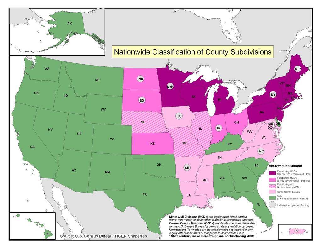
11 Illinois County Subdivisions Non-governmental precincts are found in 17 counties, mostly in the southern half of the state, areas settled historically by migrants from the South. 11
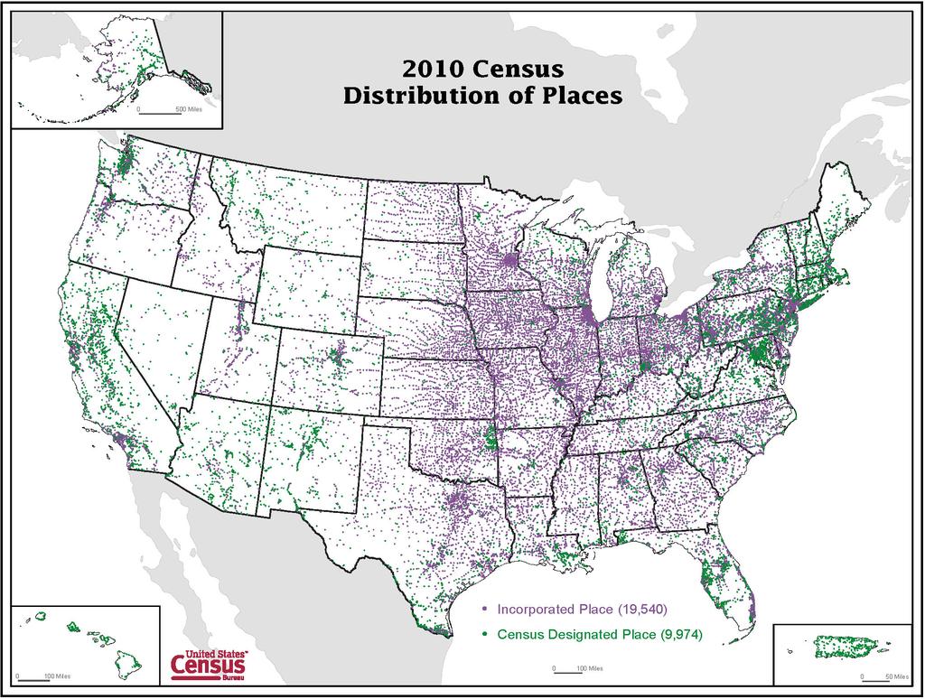
12 FILLING IN THE GAPS: CENSUS DESIGNATED PLACES 12
13 13
14 Unincorporated/Census Designated Places 1940: Supplementary report for unincorporated places. Must have population of at least : unincorporated places defined only outside urbanized areas. Must have a population of at least 1, through 1990: defined inside urbanized areas, with the minimum population threshold declining from 10,000 to 5,000, then to 2,500 during this period. Outside urbanized areas, population of at least 1, to present: no minimum population threshold. 14


15 Census Designated Places In states in which communities tend not to incorporate as cities, towns, or villages, CDPs are critical for providing place-level data. 15

16 Census 2000: Minimum population requirements for Census Designated Places were eliminated to support identification of colonias and other small, unincorporated communities to improve access to data about demographic characteristics. 16

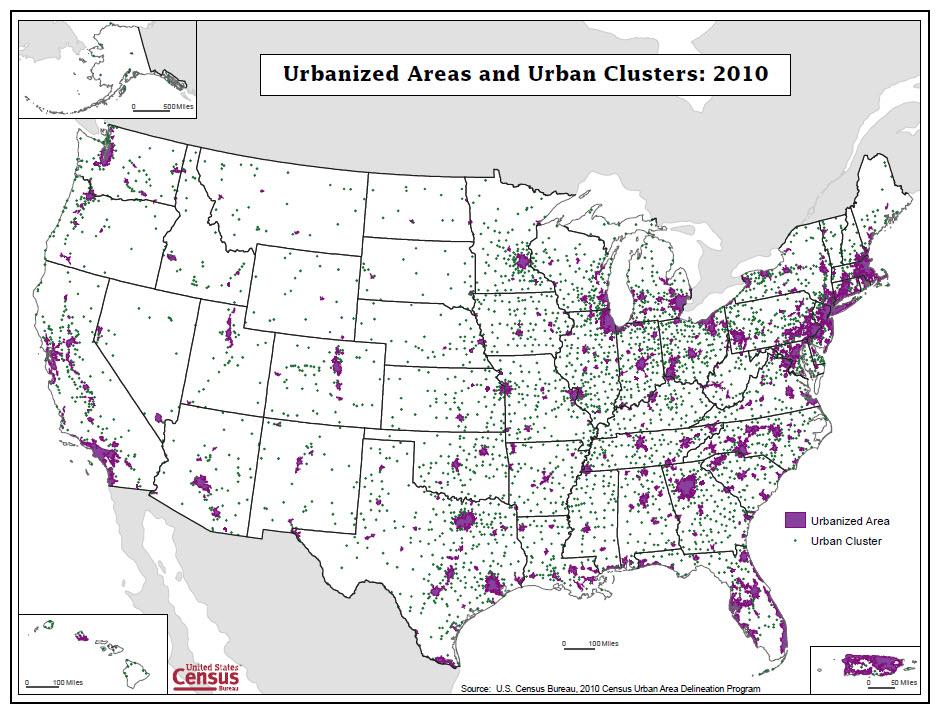
17 Starr County, TX Colonia/CDPs Mikes CDP/colonia 17

18 Incorporated places and CDPs: Tri-Cities and vicinity 18


19 Providing data for small, rural unincorporated communities: Summertown CDP, population
20 URBAN AND METROPOLITAN AREAS: DEFINING THE STRUCTURAL AND FUNCTIONAL LANDSCAPE 20
21 Urban/Rural and Metropolitan The history of the urban/rural and metropolitan classifications has been one of response to: Changes to settlement patterns in and around cities; i.e., increasing suburbanization. Changes in theoretical approaches to interpreting and understanding the growth of urban areas. Improved technology (i.e., GIS, digital databases) making it easier to manage large amounts of data. Increased spatial resolution of statistical and geospatial data. 21
22 Urban Population as a Percentage of Total US Population, Percent Urban : 2,500 threshold adopted. 1950: urbanized areas of 50,000+ adopted. 2000: urban clusters of 2,500-49,999 adopted. 22
23 Industrial Districts (1905) and Metropolitan Districts ( )

24 Urbanized Areas, Adoption of concept to account for increased suburban growth around large cities. Adherence to place boundaries. Delineated manually/interactively. Delineation built from previous decade s boundary. 24


25 Urban Area Criteria Changes, Rural portions of Oklahoma City 1960 Census: Twin central cities totaling 50,000 or more persons Census: Extended cities split between urban and rural components. 25

26 Changes to the Urban Area Concept and Criteria for Census 2000 Urban clusters adopted, extending the urbanized area concept to smaller places. Place boundaries not considered when delineating areas. Automated delineation to improve efficiency and consistency
27
28 Metropolitan Areas: Though the names have changed, the concept remained (essentially) the same: Standard Metropolitan Areas Standard Metropolitan Statistical Areas, Standard Consolidated Statistical Areas Metropolitan Statistical Areas, Consolidated Metropolitan Statistical Areas, Primary Metropolitan Statistical Areas Metropolitan and Micropolitan Statistical Areas, Combined Statistical Areas, Metropolitan Divisions 28
29 Standard Metropolitan Areas:

30 Metropolitan and Micropolitan Statistical Areas:
31 Rural Statistical Areas Conceptual and Definitional Issues to Consider What is rural? What characterizes rurality? Low population density. Small numbers of people. Low levels of urbanization/urban population. Distance from/proximity to [larger] urban centers. Isolation and remoteness. 31

32 Rural Statistical Areas Comparative Density Approach: National Percentage Scores Based on J. Adams, Classifying Settled Areas of the United States: Conceptual Issues and Proposals for New Approaches, in D. Dahmann and J. Fitzsimmons (eds.), Metropolitan and Nonmetropolitan Areas: New Approaches to Geographical Definition. U.S. Census Bureau, Population Division, Working Paper Number 12, September

33 Rural Statistical Areas Comparative Density Approach: State Percentage Scores Based on J. Adams, Classifying Settled Areas of the United States: Conceptual Issues and Proposals for New Approaches, in D. Dahmann and J. Fitzsimmons (eds.), Metropolitan and Nonmetropolitan Areas: New Approaches to Geographical Definition. U.S. Census Bureau, Population Division, Working Paper Number 12, September

, Metropolitan and Nonmetropolitan Areas: New Approaches to Geographical Definition. U.S.")
34 Rural Statistical Areas Comparative Density Approach: Overall Scores Based on J. Adams, Classifying Settled Areas of the United States: Conceptual Issues and Proposals for New Approaches, in D. Dahmann and J. Fitzsimmons (eds.), Metropolitan and Nonmetropolitan Areas: New Approaches to Geographical Definition. U.S. Census Bureau, Population Division, Working Paper Number 12, September
35 Concluding Thoughts Census Bureau geography reflects the variety of geographic areas that exist and vary across the nation. This variety has some basis in historical settlement patterns, but also reflects changing perceptions and data user needs. Understanding the history behind Census Bureau geography helps us to understand the reasons for the variety, and adds richness to statistical data. 35
36 Questions? Comments? Contact information: Michael Ratcliffe Geography Division U.S. Census Bureau
The History Behind Census Geography
 The History Behind Census Geography Michael Ratcliffe Geography Division US Census Bureau Kentucky State Data Center Affiliate Meeting August 5, 2016 Today s Presentation A brief look at the history behind
Census Geography, Geographic Standards, and Geographic Information
 Census Geography, Geographic Standards, and Geographic Information Michael Ratcliffe Geography Division US Census Bureau New Mexico State Data Center Data Users Conference November 19, 2015 Today s Presentation
Rural Alabama. Jennifer Zanoni. Geography Division U.S. Census Bureau. Alabama State Data Center 2018 Data Conference Tuscaloosa, Alabama
 Rural Alabama Jennifer Zanoni Geography Division U.S. Census Bureau Alabama State Data Center 2018 Data Conference Tuscaloosa, Alabama May 17, 2018 Agenda Census Geography Urban/Rural Definitions County-based
US Census Bureau Geographic Entities and Concepts. Geography Division
 US Census Bureau Geographic Entities and Concepts Geography Division Geographic Concepts Addresses vs. Geographic features and entities Legal/Administrative vs. Statistical Nesting relationships (or the
Rural Pennsylvania: Where Is It Anyway? A Compendium of the Definitions of Rural and Rationale for Their Use
 Rural Pennsylvania: Where Is It Anyway? A Compendium of the Definitions of Rural and Rationale for Their Use Pennsylvania Office of Rural Health 310 Nursing Sciences Building University Park, PA 16802
DRAFT RURAL-URBAN POPULATION CHANGE IN PUERTO RICO, 1990 TO 2000
 DRAFT RURAL-URBAN POPULATION CHANGE IN PUERTO RICO, 1990 TO 2000 Mei-Ling Freeman Geographic Standards and Criteria Branch Geography Division US Census Bureau For presentation at the Western Regional Science
Spatial Organization of Data and Data Extraction from Maptitude
 Spatial Organization of Data and Data Extraction from Maptitude N. P. Taliceo Geospatial Information Sciences The University of Texas at Dallas UT Dallas GIS Workshop Richardson, TX March 30 31, 2018 1/
Geographic Products and Data. Improvements in Spatial Accuracy and Accessing Data
 Geographic Products and Data Improvements in Spatial Accuracy and Accessing Data How it Began TIGER was internally developed to support the 1990 Decennial Census operations Used data sources such as USGS
ZIP Code Tabulation Areas For Census 2000
 ZIP Code Tabulation Areas For Census 2000 NCHS, CDC Andrew Flora June 13, 2000 TIGER Operations Branch Geography Division U S C E N S U S B U R E A U Helping You Make Informed Decisions ZIP Code Tabulations
Developing Spatial Data to Support Statistical Analysis of Education
 Developing Spatial Data to Support Statistical Analysis of Education Doug Geverdt National Center for Education Statistics Education Demographic and Geographic Estimates (EDGE) Program 2016 ESRI User Conference
Intercity Bus Stop Analysis
 by Karalyn Clouser, Research Associate and David Kack, Director of the Small Urban and Rural Livability Center Western Transportation Institute College of Engineering Montana State University Report prepared
Operational Definitions of Urban, Rural and Urban Agglomeration for Monitoring Human Settlements
 Operational Definitions of Urban, Rural and Urban Agglomeration for Monitoring Human Settlements By Markandey Rai United Nations Human Settlements Programme PO Box-30030 Nairobi, Kenya Abstract The United
The 2020 Census Geographic Partnership Opportunities
 The 2020 Census Geographic Partnership Opportunities Web Adams Geographer, U.S. Census Bureau New York Regional Office 1 Geographic Partnership Opportunities The 2020 Census Local Update of Census Addresses
An Introduction to China and US Map Library. Shuming Bao Spatial Data Center & China Data Center University of Michigan
 An Introduction to China and US Map Library Shuming Bao Spatial Data Center & China Data Center University of Michigan Current Spatial Data Services http://chinadataonline.org China Geo-Explorer http://chinageoexplorer.org
International Workshop on Defining and Measuring Metropolitan Regions (Paris, France, 27 th November, 2006)
") OECD Special Session International Workshop on Defining and Measuring Metropolitan Regions (Paris, France, 27 th November, 2006) Defining an Measuring Metropolitan Areas: A Comparison between Canada and
OECD Special Session International Workshop on Defining and Measuring Metropolitan Regions (Paris, France, 27 th November, 2006) Defining an Measuring Metropolitan Areas: A Comparison between Canada and
SPATIO-TEMPORAL ANALYSIS OF URBAN POPULATION GROWTH AND DISTRIBUTION IN AURANGABAD CITY
 International Journal of Research in Social Sciences Vol. 8 Issue 3, March 2018, ISSN: 2249-2496 Impact Factor: 7.081 Journal Homepage: Double-Blind Peer Reviewed Refereed Open Access International Journal
Inclusion of Non-Street Addresses in Cancer Cluster Analysis
 Inclusion of Non-Street Addresses in Cancer Cluster Analysis Sue-Min Lai, Zhimin Shen, Darin Banks Kansas Cancer Registry University of Kansas Medical Center KCR (Kansas Cancer Registry) KCR: population-based
Colm O Muircheartaigh
 THERE AND BACK AGAIN: DEMOGRAPHIC SURVEY SAMPLING IN THE 21 ST CENTURY Colm O Muircheartaigh, University of Chicago Page 1 OVERVIEW History of Demographic Survey Sampling 20 th Century Sample Design New
Geographic Boundaries of Population Census of Japan 1
 UNITED NATIONS SECRETARIAT ESA/STAT/AC.279/P20 Department of Economic and Social Affairs October 2013 Statistics Division English only United Nations Expert Group on the Integration of Statistical and
Understanding and Measuring Urban Expansion
 VOLUME 1: AREAS AND DENSITIES 21 CHAPTER 3 Understanding and Measuring Urban Expansion THE CLASSIFICATION OF SATELLITE IMAGERY The maps of the urban extent of cities in the global sample were created using
A Case Study of Regional Dynamics of China 中国区域动态案例研究
 A Case Study of Regional Dynamics of China 中国区域动态案例研究 Shuming Bao Spatial Data Center & China Data Center University of Michigan 1:00 PM - 2:00 PM, Tue, Feb 6, 2018 EST USA A Case Study of Regional Dynamics
MEASURING RACIAL RESIDENTIAL SEGREGATION
 MEASURING RACIAL RESIDENTIAL SEGREGATION Race Relations Institute Fisk University 1000 Seventeenth Ave. North Nashville, Tennessee 37208 615/329-8575 WHERE WE LIVE: THE COLOR LINE The color line is carved
Gentrification Trends in the United States,
 Gentrification Trends in the United States, 1970-2010 Richard W. Martin, Department of Insurance, Legal, Studies, and Real Estate, Terry College of Business, University of Georgia, 206 Brooks Hall, Athens,
Key Issue 1: Where Are Services Distributed? INTRODUCING SERVICES AND SETTLEMENTS LEARNING OUTCOME DESCRIBE THE THREE TYPES OF SERVICES
 Revised 2017 NAME: PERIOD: Rubenstein: The Cultural Landscape (12 th edition) Chapter Twelve Services and Settlements (pages 430 thru 457) This is the primary means by which you will be taking notes this
CHAPTER 1: EXPLORING GEOGRAPHY
 CHAPTER 1: EXPLORING GEOGRAPHY Please Do Now: In your PDN section of your binder answer the following with one or two sentences: What is Geography? What is Geography? The study of where people, places,
Identifying Gaps in Health Service Provision: GIS Approaches
 Identifying Gaps in Health Service Provision: GIS Approaches Errol Bamford, Graeme Hugo Errol Bamford 6th National Rural Health Conference Canberra, Australian Capital Territory, 4-7 March 2001 Identifying
Medical GIS: New Uses of Mapping Technology in Public Health. Peter Hayward, PhD Department of Geography SUNY College at Oneonta
 Medical GIS: New Uses of Mapping Technology in Public Health Peter Hayward, PhD Department of Geography SUNY College at Oneonta Invited research seminar presentation at Bassett Healthcare. Cooperstown,
Census Transportation Planning Products (CTPP)
") Census Transportation Planning Products (CTPP) Penelope Weinberger CTPP Program Manager - AASHTO September 15, 2010 1 What is the CTPP Program Today? The CTPP is an umbrella program of data products, custom
Census Transportation Planning Products (CTPP) Penelope Weinberger CTPP Program Manager - AASHTO September 15, 2010 1 What is the CTPP Program Today? The CTPP is an umbrella program of data products, custom
Rules of the territorial division
 Rules of the territorial division Janusz Dygaszewicz Central Statistical Office of Poland Jerusalem, 4-7 December 2016 Rules of territory division (the Polish case) The area of each unit of territorial
Ch. 13: Urban Patterns
 Ch. 13: Urban Patterns Name: Introduction & Case Study (p. 430-432) 1. Describe some differences between urban and rural environments. 2. Why do MDCs have a higher percentage of people living in urban
Policy Paper Alabama Primary Care Service Areas
 Aim and Purpose Policy Paper Alabama Primary Care Service Areas Produced by the Office for Family Health Education & Research, UAB School of Medicine To create primary care rational service areas (PCSA)
Subunit 4.1: 2.5 hours. Subunit 4.2: 2.75 hours. Subunit 4.3: 1.5 hours. Subunit 4.4: 3.5 hours. Subunit 4.5: 1.5 hours Unit 4 Learning Outcomes close
 Unit 4: North America The realm of North America extends from the polar regions of the Arctic in northern Canada and Alaska, all the way south through Mexico and the countries of Central America. Geographers
What are we like? Population characteristics from UK censuses. Justin Hayes & Richard Wiseman UK Data Service Census Support
 What are we like? Population characteristics from UK censuses Justin Hayes & Richard Wiseman UK Data Service Census Support Who are we? Richard Wiseman UK Data Service / Jisc Justin Hayes UK Data Service
Problems In Large Cities
 Chapter 11 Problems In Large Cities Create a list of at least 10 problems that exist in large cities. Consider problems that you have read about in this and other chapters and/or experienced yourself.
Globally Estimating the Population Characteristics of Small Geographic Areas. Tom Fitzwater
 Globally Estimating the Population Characteristics of Small Geographic Areas Tom Fitzwater U.S. Census Bureau Population Division What we know 2 Where do people live? Difficult to measure and quantify.
DEPARTMENT OF GEOGRAPHY B.A. PROGRAMME COURSE DESCRIPTION
 DEPARTMENT OF GEOGRAPHY B.A. PROGRAMME COURSE DESCRIPTION (3 Cr. Hrs) (2340100) Geography of Jordan (University Requirement) This Course pursues the following objectives: - The study the physical geographical
AP Human Geography Free-response Questions
 AP Human Geography Free-response Questions 2000-2010 2000-preliminary test 1. A student concludes from maps of world languages and religions that Western Europe has greater cultural diversity than the
Do the Causes of Poverty Vary by Neighborhood Type?
 Do the Causes of Poverty Vary by Neighborhood Type? Suburbs and the 2010 Census Conference Uday Kandula 1 and Brian Mikelbank 2 1 Ph.D. Candidate, Maxine Levin College of Urban Affairs Cleveland State
Brazil Experience in SDG data production, dissemination and capacity building
 Brazil Experience in SDG data production, dissemination and capacity building Claudio Stenner Coordinator of Geography 4th Meeting of the Working Group on Geospatial Information IAEG-SDG United Nations
Frontier and Remote (FAR) Area Codes: A Preliminary View of Upcoming Changes John Cromartie Economic Research Service, USDA
 Area Codes: A Preliminary View of Upcoming Changes John Cromartie Economic Research Service, USDA") National Center for Frontier Communities webinar, January 27, 2015 Frontier and Remote (FAR) Area Codes: A Preliminary View of Upcoming Changes John Cromartie Economic Research Service, USDA The views
National Center for Frontier Communities webinar, January 27, 2015 Frontier and Remote (FAR) Area Codes: A Preliminary View of Upcoming Changes John Cromartie Economic Research Service, USDA The views
Urbanisation Dynamics in West Africa AFRICAPOLIS I, 2015 UPDATE
 Public Disclosure Authorized Public Disclosure Authorized Urbanisation Dynamics in West Africa 1950 2010 AFRICAPOLIS I, 2015 UPDATE uy François Moriconi-Ebrard, Dominique Harre, Philipp Heinrigs Washington
A Method for Mapping Settlement Area Boundaries in the Greater Golden Horseshoe
 A Method for Mapping Settlement Area Boundaries in the Greater Golden Horseshoe Purpose This paper describes a method for mapping and measuring the lands designated for growth and urban expansion in the
GEOGRAPHY (GE) Courses of Instruction
 Courses of Instruction") GEOGRAPHY (GE) GE 102. (3) World Regional Geography. The geographic method of inquiry is used to examine, describe, explain, and analyze the human and physical environments of the major regions of the
GEOGRAPHY (GE) GE 102. (3) World Regional Geography. The geographic method of inquiry is used to examine, describe, explain, and analyze the human and physical environments of the major regions of the
Urban socioeconomic attribute differences in the border areas of Imperial County, California, USA, and Mexicali, Baja California, Mexico
 Urban socioeconomic attribute differences in the border areas of Imperial County, California, USA, and Mexicali, Baja California, Mexico James B. Pick School of Business University of Redlands, Redlands,
C) Discuss two factors that are contributing to the rapid geographical shifts in urbanization on a global scale.
 Discuss two factors that are contributing to the rapid geographical shifts in urbanization on a global scale.") AP Human Geography Unit VII. Cities and Urban Land Use Free Response Questions FRQ 1 Rapid urbanization in Least Developed Countries (LDCs) has many profound impacts for the world. Answer the following
AP Human Geography Unit VII. Cities and Urban Land Use Free Response Questions FRQ 1 Rapid urbanization in Least Developed Countries (LDCs) has many profound impacts for the world. Answer the following
LOOKING FOR THE RELATIONSHIP BETWEEN SPRAWL AND WATER QUALITY: A CASE STUDY OF GLOUCESTER COUNTY, NJ
 Middle States Geographer, 2006, 39:26-33 LOOKING FOR THE RELATIONSHIP BETWEEN SPRAWL AND WATER QUALITY: A CASE STUDY OF GLOUCESTER COUNTY, NJ Donna Moffett 1 and John Hasse 2 1 Department of Earth and
Areal Interpolation Methods using Land Cover and Street Data. Jeff Bourdier GIS Master s s Project Summer 2006
 Areal Interpolation Methods using Land Cover and Street Data Jeff Bourdier GIS Master s s Project Summer 2006 Objective The areal interpolation problem Some variable (here, population) is known in a given
Geographical Inequalities and Population Change in Britain,
 Geographical Inequalities and Population Change in Britain, 1971-2011 Chris Lloyd, Nick Bearman, Gemma Catney Centre for Spatial Demographics Research, University of Liverpool, UK Email: c.d.lloyd@liverpool.ac.uk
The Census, Urbanized Areas, and Your MPO/RPO
 The Census, Urbanized Areas, and Your MPO/RPO Alex Bond, AICP NADO Rural Transportation Peer Learning Conference August 25, 2011 1 Issues to Discuss Census background Definitions of Census geographies
Chesapeake Bay Remote Sensing Pilot Executive Briefing
 Chesapeake Bay Remote Sensing Pilot Executive Briefing Introduction In his Executive Order 13506 in May 2009, President Obama stated The Chesapeake Bay is a national treasure constituting the largest estuary
AP HUG REVIEW WELCOME TO 2 ND SEMESTER! Annette Parkhurst, M.Ed. January, 2015
 AP HUG REVIEW WELCOME TO 2 ND SEMESTER! Annette Parkhurst, M.Ed. January, 2015 Movement Globalization Latitude & Elevation Levels of Economic Activities CONNECTIONS Human Geography Human is the geography
Curriculum Unit. Instructional Unit #1
 Curriculum Unit Name of Course: AP Human Geography Grade Level(s): 9-12 Brief Description (Course Catalog): The purpose of the AP Human Geography course is to introduce students to the systematic study
Second High Level Forum on GGIM Seminar on Regional Cooperation in Geospatial Information Management Doha, Qatar, 7 February 2013
 Second High Level Forum on GGIM Seminar on Regional Cooperation in Geospatial Information Management Doha, Qatar, 7 February 2013 Overview on Geospatial Activities in Egypt BY : Eng.Nahla Seddik Mohamed
pdcensus2010 User Guide Census Demographics Database
 [Type text] Version 1.0 7 pdcensus2010 User Guide Census Demographics Database An easy-to-use, comprehensive, and up-to-date United States demographics package drawn from U.S. Census Bureau 2010 Census
LOCAL GOVERNMENT ADMINISTRATION SERIES
 Public Policy Research Center University of Missouri St. Louis LOCAL GOVERNMENT ADMINISTRATION SERIES ISSUE #3 MARCH 2017 THE GOVERNOR IN GOVERNANCE: KEEPING THE PACE by Mark Tranel, Director, Public Policy
Computing error measures for migration distance estimates in historical linked data sets
 Computing error measures for migration distance estimates in historical linked data sets Rebecca Vick, Minnesota Population Center, University of Minnesota Sula Sarkar, Minnesota Population Center, University
The Rural Health Workforce. Policy Brief Series. Data and Issues for Policymakers in: Washington Wyoming Alaska Montana Idaho
 The Health Workforce Data and Issues for Policymakers in: Washington Wyoming Alaska Montana Idaho Policy Brief Series ISSUE #1: THE RURAL HEALTH WORKFORCE: CHALLENGES AND OPPORTUNITIES ISSUE #2: THE RURAL
Urban Expansion of the City Kolkata since last 25 years using Remote Sensing
 [ VOLUME 5 I ISSUE 2 I APRIL JUNE 2018] E ISSN 2348 1269, PRINT ISSN 2349-5138 Urban Expansion of the City Kolkata since last 25 years using Remote Sensing Soumita Banerjee Researcher, Faculty Council
Improving rural statistics. Defining rural territories and key indicators of rural development
 Improving rural statistics Defining rural territories and key indicators of rural development Improving rural statistics Improving Rural Statistics In 2016, the Global Strategy to improve Agricultural
Urban settlements delimitation using a gridded spatial support
 Urban settlements delimitation using a gridded spatial support Rita Nicolau 1, Elisa Vilares 1, Cristina Cavaco 1, Ana Santos 2, Mário Lucas 2 1 - General Directorate for Territory Development DGT, Portugal
Geography and Usability of the American Community Survey. Seth Spielman Assistant Professor of Geography University of Colorado
 Geography and Usability of the American Community Survey Seth Spielman Assistant Professor of Geography University of Colorado Goals 1. To convince you that the margins of error from the American Community
Proposal for International Workshop on Defining and Measuring Metropolitan Regions. II. Definition and Measurement of Metropolitan Area in Japan
 November 20, 2006 Proposal for International Workshop on Defining and Measuring Metropolitan Regions Japanese Government I. Introduction II. Definition and Measurement of Metropolitan Area in
Introducing GIS analysis
 1 Introducing GIS analysis GIS analysis lets you see patterns and relationships in your geographic data. The results of your analysis will give you insight into a place, help you focus your actions, or
LAND COVER IN OHIO S TOWNSHIPS: AN ANALYSIS OF TOWNSHIP LAND COVER AND POPULATION CHANGE
 THE EXURBAN CHANGE PROJECT REPORT NUMBER EX-3: LAND COVER IN OHIO S TOWNSHIPS: AN ANALYSIS OF TOWNSHIP LAND COVER AND POPULATION CHANGE (FEBRUARY 2002) Prepared by: Jason W. Reece Data Manager & GIS Analyst
KING FAHD UNIVERSITY OF PETROLEUM & MINERALS
 KING FAHD UNIVERSITY OF PETROLEUM & MINERALS Department of City & Regional Planning Introduction To GIS (CRP 514) Identifying & Planning Public School Facility In California Using GIS Presented to Dr.
2011 Built-up Areas - Methodology and Guidance
 2011 Built-up Areas - Methodology and Guidance June 2013 Version: 2013 v1 Office for National Statistics 2013 Contents 1. Introduction... 3 2. Methodology... 3 2.1 Identifying built-up areas for the 2011
URBAN CHANGE DETECTION OF LAHORE (PAKISTAN) USING A TIME SERIES OF SATELLITE IMAGES SINCE 1972
 USING A TIME SERIES OF SATELLITE IMAGES SINCE 1972") URBAN CHANGE DETECTION OF LAHORE (PAKISTAN) USING A TIME SERIES OF SATELLITE IMAGES SINCE 1972 Omar Riaz Department of Earth Sciences, University of Sargodha, Sargodha, PAKISTAN. omarriazpk@gmail.com ABSTRACT
URBAN CHANGE DETECTION OF LAHORE (PAKISTAN) USING A TIME SERIES OF SATELLITE IMAGES SINCE 1972 Omar Riaz Department of Earth Sciences, University of Sargodha, Sargodha, PAKISTAN. omarriazpk@gmail.com ABSTRACT
Unit 1 All. Study online at quizlet.com/_3l51hr
 Unit 1 All Study online at quizlet.com/_3l51hr 1. geography: 4. 7 APHG Units+: The study of the distribution and interaction of physical and human features on the earth 2. physical geography: 1. Geography:
Delta School District 1
 Delta School District Social Studies Curriculum Scope and Sequence K-12 GLE Principles of Constitutional Democracy K 1 2 3 4 5 6 7 8 9-12 1. Knowledge of the principles expressed in documents shaping constitutional
Application Issues in GIS: the UCL Centre for Advanced Spatial Analysis. Paul Longley UCL
 Application Issues in GIS: the UCL Centre for Advanced Spatial Analysis Paul Longley UCL GIS: inclusive, shared understanding Geodemographics as a focus of interest Profiling public goods and services
Grade 9 Social Studies Canadian Identity. Chapter 3 Review Canada s People. Chapter 3: Canada s People
 Grade 9 Social Studies Canadian Identity Chapter 3 Review Canada s People Chapter 3: Canada s People Terms (notes or textbook) Population Distribution Site Factors Seigneurial system Corridors Urbanization
Improving TIGER, Hidden Costs: The Uncertain Correspondence of 1990 and 2010 U.S. Census Geography
 Improving TIGER, Hidden Costs: The Uncertain Correspondence of 1990 and 2010 U.S. Census Geography Jonathan P. Schroeder ABSTRACT: The U.S. Census Bureau supplies GIS-compatible definitions of census geographic
Tracey Farrigan Research Geographer USDA-Economic Research Service
 Rural Poverty Symposium Federal Reserve Bank of Atlanta December 2-3, 2013 Tracey Farrigan Research Geographer USDA-Economic Research Service Justification Increasing demand for sub-county analysis Policy
Negative Exponential Model Parameters and Centralization in Large Urban Areas in the U.S.,
 Negative Exponential Model Parameters and Centralization in Large Urban Areas in the U.S., 1950-2010 Abstract John R. Ottensmann Indiana University-Purdue University Indianapolis john.ottensmann@gmail.com
The trends and patterns of urbanization in the NCT of Delhi during
 International Journal of Interdisciplinary and Multidisciplinary Studies (IJIMS), 2015, Vol 2, No.4, 27-39. 27 Available online at http://www.ijims.com ISSN: 2348 0343 The trends and patterns of urbanization
AP Human Geography Free Response Questions Categorized
 AP Human Geography Free Response Questions Categorized 2002-2010 2. Population (13-17%) 3. Over the past 150 years, Europe has changed from a source to a destination region for international migration.
RELATIONAL DATA MODELING TO ENHANCE GIS-BASED VISUAL INFORMATION SYSTEMS
 RELATIONAL DATA MODELING TO ENHANCE GIS-BASED VISUAL INFORMATION SYSTEMS Matthew A. North, Washington & Jefferson College, mnorth@washjeff.edu Samuel B. Fee, Washington & Jefferson College, sfee@washjeff.edu
Urban Process and Future Development of Colombo Metropolitan Area, Sri Lanka: An Application of Geospatial Techniques
 Urban Process and Future Development of Colombo Metropolitan Area, Sri Lanka: An Application of Geospatial Techniques January 2017 Suwandaralalage Indika Shyamantha SUBASINGHE Urban Process and Future
Empowering Local Health through GIS
 Empowering Local Health through GIS Mapping data from Washington s Immunization Information System (IIS). Presented to IACW October 16 th, 2013 by: Chris Halsell and Isaiah Berg Agenda IIS Overview Why
Spotlight on Population Resources for Geography Teachers. Pat Beeson, Education Services, Australian Bureau of Statistics
 Spotlight on Population Resources for Geography Teachers Pat Beeson, Education Services, Australian Bureau of Statistics Population Population size Distribution Age Structure Ethnic composition Gender
Too Close for Comfort
 Too Close for Comfort Overview South Carolina consists of urban, suburban, and rural communities. Students will utilize maps to label and describe the different land use classifications. Connection to
British Household Panel Survey, waves 1-17 ( )
") UK Data Archive Study Number 6032 - British Household Panel Survey, Waves 1-17, 1991-2008: Conditional Access, Rural-Urban s British Household Panel Survey, waves 1-17 (1991-2008) User Documentation: Rural-Urban
UK Data Archive Study Number 6032 - British Household Panel Survey, Waves 1-17, 1991-2008: Conditional Access, Rural-Urban s British Household Panel Survey, waves 1-17 (1991-2008) User Documentation: Rural-Urban
Presentation to the National Association of Counties Large Urban County Caucus 2016 Innovation Symposium. New York, NY November 2016
 Presentation to the National Association of Counties Large Urban County Caucus 2016 Innovation Symposium New York, NY November 2016 Large counties are leading a shift in the country s economic landscape
It is clearly necessary to introduce some of the difficulties of defining rural and
 UNIT 2 CHANGING HUMAN ENVIRONMENTS G2 Theme 2 Investigating Settlement Change in MEDCs 2.1 What are the distinctive features of settlements? It is clearly necessary to introduce some of the difficulties
A Comprehensive Method for Identifying Optimal Areas for Supermarket Development. TRF Policy Solutions April 28, 2011
 A Comprehensive Method for Identifying Optimal Areas for Supermarket Development TRF Policy Solutions April 28, 2011 Profile of TRF The Reinvestment Fund builds wealth and opportunity for lowwealth communities
ITEM 11 Information June 20, Visualize 2045: Update to the Equity Emphasis Areas. None
 ITEM 11 Information June 20, 2018 Visualize 2045: Update to the Equity Emphasis Areas Staff Recommendation: Issues: Background: Briefing on the TPB-approved methodology to update the Equity Emphasis Areas
Identifying Megaregions in the US: Implications for Infrastructure Investment
 7. 10. 2 0 08 Identifying Megaregions in the US: Implications for Infrastructure Investment Dr. Myungje Woo Dr. Catherine L. Ross Jason Barringer Harry West Jessica Lynn Harbour Doyle Center for Quality
Milford Public Schools Curriculum
 Milford Public Schools Curriculum Department: Social Studies Grade 3 Course Name: Communities Course Description In third grade, students will engage in a yearlong study of communities and specifically
AP Human Geography. Course Outline Geography: Its Nature and Perspectives: Weeks 1-4
 AP Human Geography The Course The AP Human Geography course is designed to provide secondary students with the equivalent of one semester of a college introductory human geography class. The purpose of
Linking Industry and Occupation Clusters in Regional Economic Development
 Linking Industry and Occupation Clusters in Regional Economic Development Charting the Course for Regional Development: First Annual EDA Economic Development Research Symposium Clarion Hotel Morgan Morgantown,
Understanding and accessing 2011 census aggregate data
 Understanding and accessing 2011 census aggregate data 4 July 11:00 to 16:00 BST Justin Hayes and Richard Wiseman UK Data Service Census Support UK censuses provide an unparalleled resource of high quality
Transport Planning in Large Scale Housing Developments. David Knight
 Transport Planning in Large Scale Housing Developments David Knight Large Scale Housing Developments No longer creating great urban spaces in the UK (Hall 2014) Transport Planning Transport planning processes
Short Communication Urban and rural temperature trends in proximity to large US cities:
 INTERNATIONAL JOURNAL OF CLIMATOLOGY Int. J. Climatol. 27: 1801 1807 (2007) Published online 7 September 2007 in Wiley InterScience (www.interscience.wiley.com).1555 Short Communication Urban and rural
GEOGRAPHY QUESTION PAPER CODE 64/1/1. 4. Distinguish between towns and villages on the basis of occupation. 1
 GEOGRAPHY Time allowed : 3 hours Maximum Marks : 70 GENERAL INSTRUCTIONS : (i) (ii) There are 22 geneal questions. Question numbers 1-7 are very short answer questions carrying 1 mark each. Answer to these
Telling Stories with Numbers Secondary data collection, presentation, and interpretation
 10/10/2013 Telling Stories with Numbers Secondary data collection, presentation, and interpretation Vincent Adams Coordinator, Rural Communities Explorer Oregon State University www.oregonexplorer.info/rural
Using American Factfinder
 Using American Factfinder What is American Factfinder? American Factfinder is a search engine that provides access to the population, housing and economic data collected by the U.S. Census Bureau. It can
c. What is the most distinctive above ground result of high land costs and intensive land use? i. Describe the vertical geography of a skyscraper?
 AP Human Geography Unit 7b Guided Reading: Urban Patterns and Social Issues Mr. Stepek Key Issue #1: Why Do Services Cluster Downtown? (Rubenstein p 404 410) 1. What is the CBD? What does it contain and
Visualization of Origin- Destination Commuter Flow Using CTPP Data and ArcGIS
 Visualization of Origin- Destination Commuter Flow Using CTPP Data and ArcGIS Research & Analysis Department Southern California Association of Governments 2015 ESRI User Conference l July 23, 2015 l San
UNCERTAINTY IN THE POPULATION GEOGRAPHIC INFORMATION SYSTEM
 UNCERTAINTY IN THE POPULATION GEOGRAPHIC INFORMATION SYSTEM 1. 2. LIU De-qin 1, LIU Yu 1,2, MA Wei-jun 1 Chinese Academy of Surveying and Mapping, Beijing 100039, China Shandong University of Science and
Name Date Period Barron s (6 th edition) Chapter 7 Urban Geography
 Chapter 7 Urban Geography") Name Date Period Barron s (6 th edition) Chapter 7 Urban Geography Historical Geography of Urban Environments 1. In what way did the development of different types of occupations (carpenters, merchants,
Name Date Period Barron s (6 th edition) Chapter 7 Urban Geography Historical Geography of Urban Environments 1. In what way did the development of different types of occupations (carpenters, merchants,