The Macalester Geography Crow River Watershed Project
|
|
|
- Emory Chambers
- 5 years ago
- Views:
Transcription
1 The Macalester Geography Crow River Watershed Project A Collaborative Project Between: Advanced d GIS Cities of the 21 st Century Urban Geography Field Seminar Talk Overview Introduction to the Project Brief Overview of the Crow River Watershed Project Objectives & Goals Environmental & Physical Components in the Watershed Critical Land Cover Ethanol Production Polluted Waters Ashley Nepp, Cities of the 21 st Century: Fish Ladders Social & Economic Components in the Watershed Poverty and Female Headed Households Free and Reduced Lunches Educational Attainment and Median Household Income Clare Reuning, Urban Geography: Latino Immigration Patterns Project Challenges Other Research Closing Remarks 1


2 Who s in, What s up? Collaboration between three geography classes: Cities of the Twenty First Century: a research seminar designed to examine and understand the nature of Urban areas in North America Dan Trudeau Urban Geography Field Seminar: a similar seminar with a strong focus on field research Dave Lanegran Advanced GIS: an upper level GIS course designed to improve foundational GIS skills and engage in project-based work Holly Barcus, Birgit Muehlenhaus We're putting together an atlas of the Crow River Watershed; Advanced GIS will provide maps for visual references to the seminars' research projects Atlas as a reference point Not oriented towards a particular research question 2

 The Crow River is made up of three branches: North Fork of the Crow River: about 120 mi (195 km) long Middle Fork of the Crow River: about 50 mi (80 km) long South Fork of the Crow River:")
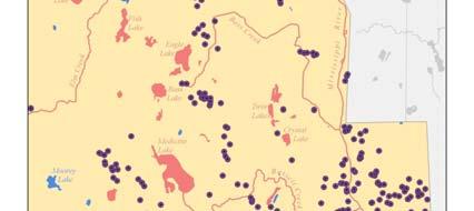
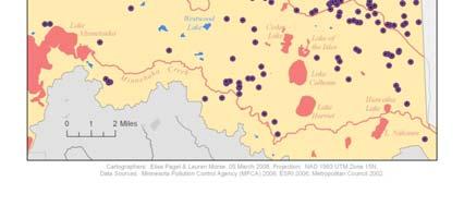
3 The Crow River Watershed What is a Watershed? "An extent of land where water from rain or snow melt drains downhill into a body of water, such as a river, lake, dam, estuary, wetland, sea, or ocean. The drainage basin includes both the streams and rivers that convey the water as well as the land surfaces from which water drains into those channels, separated from adjacent basins by a drainage divide. (Wikipedia) The Crow River is made up of three branches: North Fork of the Crow River: about 120 mi (195 km) long Middle Fork of the Crow River: about 50 mi (80 km) long South Fork of the Crow River: about 100 mi (160 km) long The Crow River basin is about 2,725 square miles The North and South Fork of the Crow River converge in Rockford, MN and flow into the Mississippi river at Dayton, Minnesota. The Crow River Watershed includes: Carver, Hennepin, Kandiyohi, McLeod, Meeker, Pope, Renville, Stearns & Sibley Counties Watershed covers 1.8 million acres primarily privately owned Primary land use is agricultural From The watershed district is represented through a consortium of individual citizens and community groups with some stake in the future of the watershed (CROW Joint Powers Board). Considering the significant increase in population and development in the Crow River Watershed, this is area is both interesting and important to draw attention to. 3
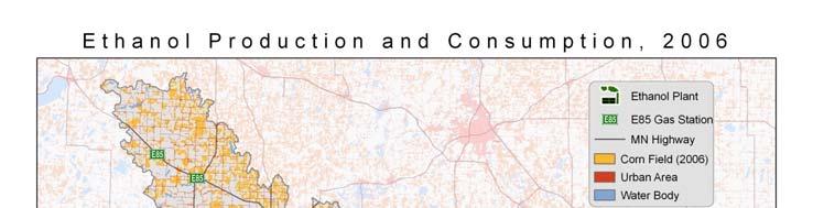
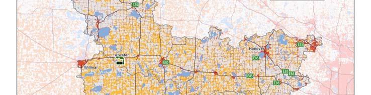
4 Goals/Objectives Allow for Macalester students to engage with a broader Minnesota community, while developing skills in research and GIS Identify and analyze the spatial patterns of various environmental and social phenomena confronting the watershed. Be able to use a combination of maps, research and theory to create an information base for further research into the issues presented. Create a highly-informative, thorough, and useful atlas of the watershed that can be readily accessed and understood by residents of the region, city planners, businesses and academics alike. Environmental & Physical Watershed Components 4

5 5

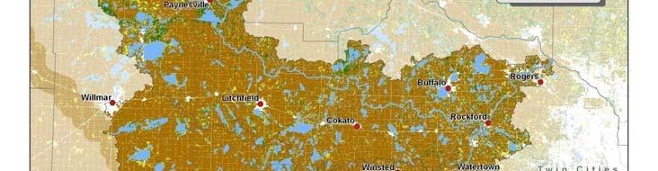
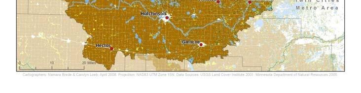
6 Hennepin County 6


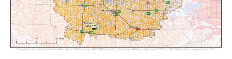
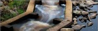
7 Fish Ladders in the Crow River Watershed Ashley Nepp Cities of the 21 st Century Hutchinson Fish Ladder The Hutchinson fish ladder project was a dam and bridge replacement project. A fish ladder is a good compromise when you need to control the flow of a river but want to have less of an impact on the river than a dam. Environmentally it would have been better to remove Environmentally, it would have been better to remove the dam and return to an uncontrolled river flow. 7

8 8


9 Social & Economic Watershed Components 9
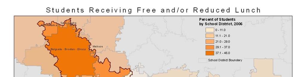

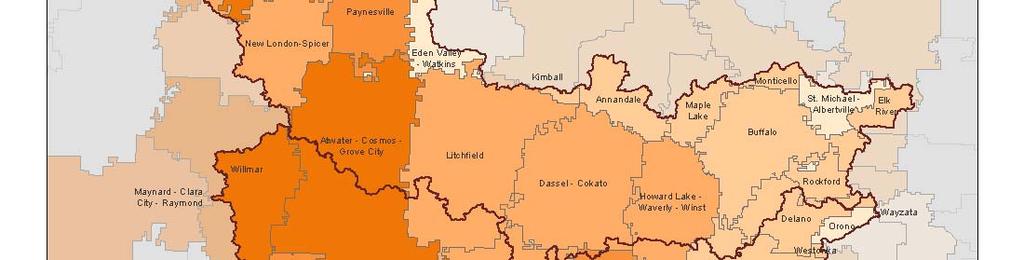
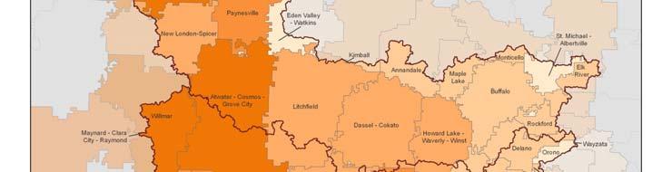

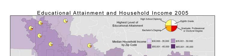

10 10


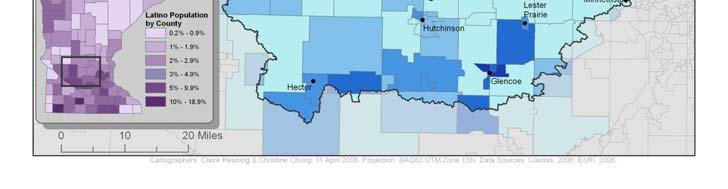
11 Filling in the Gaps: Latino Migration in the Crow River Watershed Claire Reuning GEOG 488 Spring


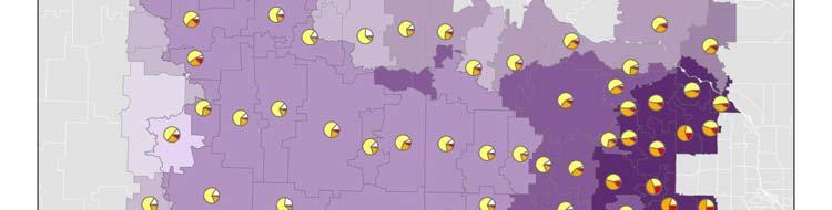
12 Latino Population Counties included: Carver, Kandiyohi, McLeod, Meeker, Pope, Renville, Sibley and Stearns. Source: U.S. Census Bureau, 2000 White Population Counties included: Carver, Kandiyohi, McLeod, Meeker, Pope, Renville, Sibley and Stearns. Source: U.S. Census Bureau,
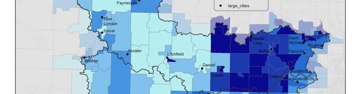
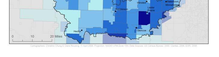
13 Latino Population White Population 13
14 Project Challenges Making maps relevant and accessible to main target audience (watershed residents) Difference in setting between the GIS/cartography and field research components of this project Issues of scale in determining where data could be obtained Understanding the effect that the Twin Cities urban system has on this region, and the data that were obtained Inconsistency of time across different projects, depending upon data availability for that particular issue Cities of the 21 st Century Projects GEOGRAPHY Competitive Charity: Effects of Healthcare Ownership in Hutchinson, Minnesota by Emily Gerteis Selling the Farm : Place marketing in Rural America by Patricia Bass Make it Happen: Fundamentals of Cooperative Community Development Projects by Ashley Nepp Turkey Production in Minnesota by Andrea Blake Governing Water: Management of the Crow River Watershed by Robyn Schindeldecker Bridging the Gap: An Analysis of the Buffalo, MN Commuter Bus Line by Joe Parilla Downtown Revitalization of Watertown, MN: Does Size Matter? by Leah Roth-Howe That s Women s Work: Availability of Child Care and Women s Workforce Participation Rates in the South Crow River Watershed by Jessica Mowles Diversity and Crow River Schools: Overview of ELL Programs in the Watershed by Katherine Bristol 14

15 Urban Geography Field Seminar Projects GEOGRAPHY Commercial Real Estate Development by Emily Goodman Filling in the Gaps: Latino Migration in the Crow River Watershed by Claire Reuning Land Use and Water Quality by Victoria Harris Mental Maps and Spatial Behavior by Elana Dahlberg Main Street Preservation and Change by Matt Wicklund Delineating the Suburban Fringe by Matt Malmberg From Conclusions The Crow River Watershed Atlas provides a broad overview as well as highlighting specific topics of the region s natural and socio-economic geography. The atlas will serve as a baseline for future research. It will be distributed to local and regional planning agencies, such as the Metropolitan Council, and Target Corporation. 15
16 Acknowledgments We would like to thank the Project Pericles and the Civic Engagement Center for their generous support. 16
Too Close for Comfort
 Too Close for Comfort Overview South Carolina consists of urban, suburban, and rural communities. Students will utilize maps to label and describe the different land use classifications. Connection to
LOUISIANA STUDENT STANDARDS FOR SOCIAL STUDIES THAT CORRELATE WITH A FIELD TRIP TO DESTREHAN PLANTATION KINDERGARTEN
 LOUISIANA STUDENT STANDARDS FOR SOCIAL STUDIES THAT CORRELATE WITH A FIELD TRIP TO DESTREHAN PLANTATION KINDERGARTEN Standard 2 Historical Thinking Skills Students distinguish between events, people, and
Frequently Asked Questions
 What is the Regional Transit Engagement Series? As one of the fastest growing regions in the country, there is recognition that long-term transit planning efforts should be accelerated if we are to remain
Minnesota K-12 Academic Standards in Social Studies. Grade 4: Geography of North America
 Minnesota K-12 Academic s in Social Studies Grade 4: Geography of North America 4 Describe how people take 1. Democratic government action to influence a depends on informed and decision on a specific
Programs Aligned With: Kindergarten Social Studies
 Programs Aligned With: Kindergarten Social Studies Progressive Waste Solutions K.2.1 Compare and contrast children and families today with those in the past using various sources K.3.2 Identify maps and
AP Human Geography Free-response Questions
 AP Human Geography Free-response Questions 2000-2010 2000-preliminary test 1. A student concludes from maps of world languages and religions that Western Europe has greater cultural diversity than the
An online data and consulting resource of THE UNIVERSITY OF TOLEDO THE JACK FORD URBAN AFFAIRS CENTER
 An online data and consulting resource of THE JACK FORD URBAN AFFAIRS CENTER THE CENTER FOR GEOGRAPHIC INFORMATION SCIENCE AND APPLIED GEOGRAPHICS DEPARTMENT OF GEOGRAPHY AND PLANNING THE UNIVERSITY OF
Topic 4: Changing cities
 Topic 4: Changing cities Overview of urban patterns and processes 4.1 Urbanisation is a global process a. Contrasting trends in urbanisation over the last 50 years in different parts of the world (developed,
PLANNING (PLAN) Planning (PLAN) 1
 Planning (PLAN) 1") Planning (PLAN) 1 PLANNING (PLAN) PLAN 500. Economics for Public Affairs Description: An introduction to basic economic concepts and their application to public affairs and urban planning. Note: Cross-listed
Planning (PLAN) 1 PLANNING (PLAN) PLAN 500. Economics for Public Affairs Description: An introduction to basic economic concepts and their application to public affairs and urban planning. Note: Cross-listed
3.0 ANALYSIS OF FUTURE TRANSPORTATION NEEDS
 3.0 ANALYSIS OF FUTURE TRANSPORTATION NEEDS In order to better determine future roadway expansion and connectivity needs, future population growth and land development patterns were analyzed as part of
A Comprehensive Inventory of the Number of Modified Stream Channels in the State of Minnesota. Data, Information and Knowledge Management.
 A Comprehensive Inventory of the Number of Modified Stream Channels in the State of Minnesota Data, Information and Knowledge Management Glenn Skuta Environmental Analysis and Outcomes Division Minnesota
Crow River Plaza - Retail Development South Diamond Lake Rd. Rogers, MN FOR LEASE 1,024 SF Retail Space. Lease Rate: $16.
 FEATURES: - Available in Rogers, MN Lease Rate: $16.00 / psf NNN - Excellent location with freeway signage on I-94! - Near large retailers such as Target, Kohls, & Applebees. Taxes $3.65 / psf Cam $3.20
HSC Geography. Year 2013 Mark Pages 10 Published Jul 4, Urban Dynamics. By James (97.9 ATAR)
") HSC Geography Year 2013 Mark 92.00 Pages 10 Published Jul 4, 2017 Urban Dynamics By James (97.9 ATAR) Powered by TCPDF (www.tcpdf.org) Your notes author, James. James achieved an ATAR of 97.9 in 2013 while
HSC Geography Year 2013 Mark 92.00 Pages 10 Published Jul 4, 2017 Urban Dynamics By James (97.9 ATAR) Powered by TCPDF (www.tcpdf.org) Your notes author, James. James achieved an ATAR of 97.9 in 2013 while
South Carolina Standards & Learning Science Grade: 2 - Adopted: 2014
 Main Criteria: South Carolina Standards & Learning Secondary Criteria: Subjects: Science, Social Studies Grade: 2 Correlation Options: Show Correlated South Carolina Standards & Learning Science Grade:
Grade 5: Social Studies Practices
 Grade 5: Social Studies Practices A. Gathering and Using Evidence 1. Develop questions to help identify evidence about topics related to the historical events occurring in the Western Hemisphere that can
Crow River Plaza - Retail Development South Diamond Lake Rd. Rogers, MN FOR LEASE 2,066 SF Retail Space. Lease Rate: $16.
 FEATURES: - 2,066 SF End Cap Retail Space Available in Rogers, MN - Excellent location with freeway signage on I-94! - Near large retailers such as Target, Kohls, & Applebees. - Convenient location off
Advanced Readings. Environment and Land Use Concentration The following seminars and studios would apply
 Community Development and Housing Concentration URP 720 Urban Housing Policies URP 722 Community Development and Housing URP 724 Urban Revitalization Studio URP 726 Citizen Participation Strategies URP
ADMINISTRATION DEPARTMENT Land Management Information Center. An Inventory of Its Records
 MINNESOTA HISTORICAL SOCIETY Minnesota State Archives ADMINISTRATION DEPARTMENT Land Management Information Center An Inventory of Its Records OVERVIEW OF THE RECORDS Agency: Series Title: Land Management
Webinar Series for Comprehensive Plan Updates. School Districts: More than just an affected jurisdiction
 Webinar Series for Comprehensive Plan Updates School Districts: More than just an affected jurisdiction Presented by Tara Beard, AICP March 9, 2017 Goals for this webinar City planning staff are more aware
C) Discuss two factors that are contributing to the rapid geographical shifts in urbanization on a global scale.
 Discuss two factors that are contributing to the rapid geographical shifts in urbanization on a global scale.") AP Human Geography Unit VII. Cities and Urban Land Use Free Response Questions FRQ 1 Rapid urbanization in Least Developed Countries (LDCs) has many profound impacts for the world. Answer the following
AP Human Geography Unit VII. Cities and Urban Land Use Free Response Questions FRQ 1 Rapid urbanization in Least Developed Countries (LDCs) has many profound impacts for the world. Answer the following
EXAMINING THE DEMOGRAPHICS OF THE DOG RIVER WATERSHED
 EXAMINING THE DEMOGRAPHICS OF THE DOG RIVER WATERSHED Phillip B. Whatley, Department of Earth Sciences, University of South Alabama, Mobile, AL, 36688. Email: pbw401@jaguar1.usouthal.edu. Examining the
European Regional and Urban Statistics
 European Regional and Urban Statistics Dr. Berthold Feldmann berthold.feldmann@ec.europa.eu Eurostat Structure of the talk Regional statistics in the EU The tasks of Eurostat Regional statistics Urban
A Review of Concept of Peri-urban Area & Its Identification
 A Review of Concept of Peri-urban Area & Its Identification Ar. Manita Saxena Research Scholar Department of Architecture and Planning M.A.N.I.T, Bhopal Dr. Supriya Vyas Assistant Professor, Department
geographic patterns and processes are captured and represented using computer technologies
 Proposed Certificate in Geographic Information Science Department of Geographical and Sustainability Sciences Submitted: November 9, 2016 Geographic information systems (GIS) capture the complex spatial
Modeling and Predicting of Future Urban Growth in the Charleston, South Carolina Area
 Modeling and Predicting of Future Urban Growth in the Charleston, South Carolina Area Jeffery Allen Testimony presented to the U.S. Commission on Ocean Policy January 15, 2002 Charleston, South Carolina
Cultural Data in Planning and Economic Development. Chris Dwyer, RMC Research Sponsor: Rockefeller Foundation
 Cultural Data in Planning and Economic Development Chris Dwyer, RMC Research Sponsor: Rockefeller Foundation A Decade of Attempts to Quantify Arts and Culture Economic impact studies Community indicators
DETERMINE OF REGIONAL DEVELOPMENT STRATEGIES IN IZMIR
 Sukran Yalpir Asli Bozdag Saban Inam DETERMINE OF REGIONAL DEVELOPMENT STRATEGIES IN IZMIR Globalization INTRODUCTION Economic pressure cause Economic migration cause cause Spatial organizations Spatial
Bridging between organizations for effective water resource management;
 Bridging between organizations for effective water resource management; a look at a stakeholder network in water governance issues of a rural subbasin aren Trebitz hd student, Water Resources, law, mgt.,
Census Geography, Geographic Standards, and Geographic Information
 Census Geography, Geographic Standards, and Geographic Information Michael Ratcliffe Geography Division US Census Bureau New Mexico State Data Center Data Users Conference November 19, 2015 Today s Presentation
Second High Level Forum on GGIM Seminar on Regional Cooperation in Geospatial Information Management Doha, Qatar, 7 February 2013
 Second High Level Forum on GGIM Seminar on Regional Cooperation in Geospatial Information Management Doha, Qatar, 7 February 2013 Overview on Geospatial Activities in Egypt BY : Eng.Nahla Seddik Mohamed
Prentice Hall World Studies: Latin America 2005 Correlated to: Missouri Social Studies Grade Level Expectations (Grade 7)
") Principles of Constitutional Democracy 1. Knowledge of the principles expressed in documents shaping constitutional democracy in the United States A. (1) Principles expressed in documents shaping constitutional
Principles of Constitutional Democracy 1. Knowledge of the principles expressed in documents shaping constitutional democracy in the United States A. (1) Principles expressed in documents shaping constitutional
Mapping Accessibility Over Time
 Journal of Maps, 2006, 76-87 Mapping Accessibility Over Time AHMED EL-GENEIDY and DAVID LEVINSON University of Minnesota, 500 Pillsbury Drive S.E., Minneapolis, MN 55455, USA; geneidy@umn.edu (Received
M14/3/GEOGR/SP2/ENG/TZ0/XX/Q GEOGRAPHY STANDARD LEVEL PAPER 2. Monday 19 May 2014 (morning) 1 hour 20 minutes INSTRUCTIONS TO CANDIDATES
 1 hour 20 minutes INSTRUCTIONS TO CANDIDATES") M14/3/GEOGR/SP2/ENG/TZ0/XX/Q 22145203 GEOGRAPHY STANDARD LEVEL PAPER 2 Monday 19 May 2014 (morning) 1 hour 20 minutes INSTRUCTIONS TO CANDIDATES Do not open this examination paper until instructed to do
M14/3/GEOGR/SP2/ENG/TZ0/XX/Q 22145203 GEOGRAPHY STANDARD LEVEL PAPER 2 Monday 19 May 2014 (morning) 1 hour 20 minutes INSTRUCTIONS TO CANDIDATES Do not open this examination paper until instructed to do
Proposed Scope of Work Village of Farmingdale Downtown Farmingdale BOA Step 2 BOA Nomination Study / Draft Generic Environmental Impact Statement
 Proposed Scope of Work Village of Farmingdale Downtown Farmingdale BOA Step 2 BOA Nomination Study / Draft Generic Environmental Impact Statement The scope of work that follows incorporates and covers
Graduate Courses Meteorology / Atmospheric Science UNC Charlotte
 Graduate Courses Meteorology / Atmospheric Science UNC Charlotte In order to inform prospective M.S. Earth Science students as to what graduate-level courses are offered across the broad disciplines of
Nature s Art Village
 Nature s Art Village Educational Field Trip Programs Guide To: College, Career & Civic Life C3 Framework For Social Studies State Standards Grades 3 through 5 All That Glitters Children journey back in
UGRC 144 Science and Technology in Our Lives/Geohazards
 UGRC 144 Science and Technology in Our Lives/Geohazards Flood and Flood Hazards Dr. Patrick Asamoah Sakyi Department of Earth Science, UG, Legon College of Education School of Continuing and Distance Education
Technical Memorandum #2 Future Conditions
 Technical Memorandum #2 Future Conditions To: Dan Farnsworth Transportation Planner Fargo-Moorhead Metro Council of Governments From: Rick Gunderson, PE Josh Hinds PE, PTOE Houston Engineering, Inc. Subject:
Joint Planning Advisory Council July 19, 2011
 Joint Planning Advisory Council July 19, 2011 Global Cities Program Objectives Helping advance strategic thinking in a variety of critical areas. Facilitating informed decisionmaking on the part of public
An Assessment of People, Place and Business on Syracuse s Near Northside
 An Assessment of People, Place and Business on Syracuse s Near Northside May 2013 Report produced by Jon Glass, Kelly Montague and Mark Pawliw Edited by Jon Glass and Jonnell Robinson Syracuse Community
Telling Stories with Numbers Secondary data collection, presentation, and interpretation
 10/10/2013 Telling Stories with Numbers Secondary data collection, presentation, and interpretation Vincent Adams Coordinator, Rural Communities Explorer Oregon State University www.oregonexplorer.info/rural
"Natural" Cultural Districts and Neighborhood Revitalization
 University of Pennsylvania ScholarlyCommons Culture and Community Revitalization: A Collaboration Social Impact of the Arts Project 6-2009 "Natural" Cultural Districts and Neighborhood Revitalization Mark
A Preliminary Model of Community-based Integrated Information System for Urban Spatial Development
 A Preliminary Model of Community-based Integrated Information System for Urban Spatial Development Bauni HAMID 1, Devin DEFRIZA 2 1 2 CAITAD (Center of Applied Information Technology in Planning and Design),
The Road to Data in Baltimore
 Creating a parcel level database from high resolution imagery By Austin Troy and Weiqi Zhou University of Vermont, Rubenstein School of Natural Resources State and local planning agencies are increasingly
PERCEPTION and Focus on Maps. Focus on Maps 8/29/2014. English and Dutch Maps from the 1600s and 1680 British Maps of N. Am.
 PERCEPTION English and Dutch Maps from the 600s The Nature of New York Dutch67 Prof. Anthony Grande English 67 Copyright 04 AFG 676 and 680 British Maps of N. Am. 70 and 776 4 Focus on Maps Maps are geographers
 Red River Flooding June 2015 Caddo and Bossier Parishes Presented by: Flood Technical Committee Where the Rain Falls Matters I-30 versus I-20 I-20 Backwater and Tributary Floods (Localized) 2016 Flood
Working with Natural Stream Systems
 Working with Natural Stream Systems Graydon Dutcher Delaware County Soil & Water Conservation District Stream Corridor Management Program Tropical Storm Sandy October 29,2012 What is a Watershed?
Social Studies (4) Social Science
 Social Science") Scope And Sequence Timeframe Unit Instructional Topics 8 Day(s) Course Overview Students will learn about the regions of the United States with emphasis on local and state history, geography, government,
Scope And Sequence Timeframe Unit Instructional Topics 8 Day(s) Course Overview Students will learn about the regions of the United States with emphasis on local and state history, geography, government,
How Irrigation Affected the Geography of Northeast Oregon
 Delia Wallis How Irrigation Affected the Geography of Northeast Oregon Grade Levels: 4 (with ability to move up or down) Time: two x 45-minute sessions Overview: Students are going to study topographical
Advanced Placement Human Geography
 Advanced Placement Human Geography Introduction to AP Human Geography The Advanced Placement course in Human Geography is designed to introduce students to the systematic study of the processes that have
Medical GIS: New Uses of Mapping Technology in Public Health. Peter Hayward, PhD Department of Geography SUNY College at Oneonta
 Medical GIS: New Uses of Mapping Technology in Public Health Peter Hayward, PhD Department of Geography SUNY College at Oneonta Invited research seminar presentation at Bassett Healthcare. Cooperstown,
South Carolina Standards & Learning Science Grade: 1 - Adopted: 2014
 Main Criteria: South Carolina Standards & Learning Secondary Criteria: Subjects: Science, Social Studies Grade: 1 Correlation Options: Show Correlated South Carolina Standards & Learning Science Grade:
DEPARTMENT OF GLOBAL STUDIES AND GEOGRAPHY COURSES OFFERED - FALL 18 SEMESTER GEOGRAPHY
 DEPARTMENT OF GLOBAL STUDIES AND GEOGRAPHY What Should You Take First? COURSES OFFERED - FALL 18 SEMESTER GEOGRAPHY Besides our Senior Seminars (and Geog 160), our classes can be taken at any time, whether
Planning for Economic and Job Growth
 Planning for Economic and Job Growth Mayors Innovation Project Winter 2012 Meeting January 21, 2012 Mary Kay Leonard Initiative for a Competitive Inner City AGENDA The Evolving Model for Urban Economic
TRI-STATE WATERS COMMISSON An Inventory of Its Red River of the North Drainage Basin Maps and Graphs
 MINNESOTA HISTORICAL SOCIETY Minnesota State Archives TRI-STATE WATERS COMMISSON An Inventory of Its Red River of the North Drainage Basin Maps and Graphs OVERVIEW OF THE RECORDS Agency: Tri-State Waters
MULTIPLE CHOICE. Choose the one alternative that best completes the statement or answers the question.
 AP Test 13 Review Name MULTIPLE CHOICE. Choose the one alternative that best completes the statement or answers the question. 1) Compared to the United States, poor families in European cities are more
Census Urban Area Comparisons, 2000 to 2010
 THE HONORABLE ROGERS Mayor ANDERSON, Karl Dean, CHAIRMAN Chairman Census Urban Area Comparisons, 2000 to 2010 TCC May 2, 2012 MPOs/RPOs in Tennessee Regional Geographies in Middle TN Nashville MPO Clarksville
CHAPTER 1: EXPLORING GEOGRAPHY
 CHAPTER 1: EXPLORING GEOGRAPHY Please Do Now: In your PDN section of your binder answer the following with one or two sentences: What is Geography? What is Geography? The study of where people, places,
Trip Generation Model Development for Albany
 Trip Generation Model Development for Albany Hui (Clare) Yu Department for Planning and Infrastructure Email: hui.yu@dpi.wa.gov.au and Peter Lawrence Department for Planning and Infrastructure Email: lawrence.peter@dpi.wa.gov.au
Hennepin GIS. Tree Planting Priority Areas - Analysis Methodology. GIS Services April 2018 GOAL:
 Hennepin GIS GIS Services April 2018 Tree Planting Priority Areas - Analysis Methodology GOAL: To create a GIS data layer that will aid Hennepin County Environment & Energy staff in determining where to
Chapter 10 Human Settlement Geography Book 1 Class 12
 CHAPTER 10 HUMAN SETTLEMENTS 1. RURAL, SUB URBAN AND URBAN SETTLEMENTS: This classification is common worldwide but the criteria differ from country to country. 5. Criteria for classification differs from
POTENTIAL COURSES FOR CEP STUDENTS AND THEIR AREAS OF INTERST
 POTENTIAL COURSES FOR CEP STUDENTS AND THEIR AREAS OF INTERST C ENV 110 Food & Environment CHSTU 320 Food Sovereignty in Mexico and the United States ANTH 361 Anthropology of Food ANTH 488 Agroecology
Route 88 Effects on the Town of Westport. Life time observations. By: Claude A. Ledoux
 Route 88 Effects on the Town of Westport. Life time observations By: Claude A. Ledoux. 1-28-2018 Two events of the last Century that had the greatest impact on the Town of Westport. 1 st. World War II.
Your web browser (Safari 7) is out of date. For more security, comfort and the best experience on this site: Update your browser Ignore
 is out of date. For more security, comfort and the best experience on this site: Update your browser Ignore") Your web browser (Safari 7) is out of date. For more security, comfort and the best experience on this site: Update your browser Ignore urban area For the complete encyclopedic entry with media resources,
Your web browser (Safari 7) is out of date. For more security, comfort and the best experience on this site: Update your browser Ignore urban area For the complete encyclopedic entry with media resources,
Understanding Land Use and Walk Behavior in Utah
 Understanding Land Use and Walk Behavior in Utah 15 th TRB National Transportation Planning Applications Conference Callie New GIS Analyst + Planner STUDY AREA STUDY AREA 11 statistical areas (2010 census)
Income Inequality in Missouri 2000
 Through the growth in global media, people around the world are becoming more aware of and more vocal about the gap between the rich and the poor. Policy makers, researchers and academics are also increasingly
The CRP stresses a number of factors that point to both our changing demographics and our future opportunities with recommendations for:
 Plan Overview The CRP represents the first broad planning initiative covering Lake, Porter and LaPorte counties. Unlike previous plans released by NIRPC, which focused primarily on transportation, the
Modeling Urban Sprawl: from Raw TIGER Data with GIS
 Modeling Urban Sprawl: from Raw TIGER Data with GIS Brady Foust University of Wisconsin-Eau Claire Lisa Theo University of Wisconsin-Stevens Point Modeling Urban Sprawl 1 Problem How to model & predict
MARS AREA SCHOOL DISTRICT CURRICULUM GRADE: Grade 4
 MARS AREA SCHOOL DISTRICT CURRICULUM GRADE: Grade 4 Course Title: Social Studies Brief Description Overview: Students will explore the history, geography, government, and economy of the United States with
K- 5 Academic Standards in. Social Studies. June 2013
 K- 5 Academic s in Social Studies June 2013 Word Tables of s ONLY This Word version of the 2.17.12 social studies standards (DRAFT for Rulemaking 2.17.12) document contains the standards ONLY; no explanatory
Population Profiles
 U N D E R S T A N D I N G A N D E X P L O R I N G D E M O G R A P H I C C H A N G E MAPPING AMERICA S FUTURES, BRIEF 6 2000 2010 Population Profiles Atlanta, Las Vegas, Washington, DC, and Youngstown Allison
AP Human Geography AP EXAM Free Response Questions and Possible Future Questions
 AP Human Geography AP EXAM Free Response Questions and Possible Future Questions FRQ Exam Questions: Population & Migration 2003- European Migration and Demographic Transition Model 2004- Population Pyramids
CHAPTER 3 POPULATION AND CULTURE SECTION 1: THE STUDY OF HUMAN GEOGRAPHY
 CHAPTER 3 POPULATION AND CULTURE SECTION 1: THE STUDY OF HUMAN GEOGRAPHY THE STUDY OF HUMAN GEOGRAPHY Human geography includes many topics Language Religion Customs Economics Political Systems One particular
U.S. ARMY CORPS OF ENGINEERS
 CORPS FACTS Regulating Mississippi River Navigation Pools U.S. ARMY CORPS OF ENGINEERS BUILDING STRONG Historical Background Federal improvements in the interest of navigation on the Mississippi River
COURSES OUTSIDE THE JOURNALISM SCHOOL
 COURSES OUTSIDE THE JOURNALISM SCHOOL Students are not limited to the science courses on this list and may select classes from additional specialties. In accordance with University policy, 400-level courses
Social Studies Grade 2 - Building a Society
 Social Studies Grade 2 - Building a Society Description The second grade curriculum provides students with a broad view of the political units around them, specifically their town, state, and country.
PALS: Neighborhood Identification, City of Frederick, Maryland. David Boston Razia Choudhry Chris Davis Under the supervision of Chao Liu
 PALS: Neighborhood Identification, City of Frederick, Maryland David Boston Razia Choudhry Chris Davis Under the supervision of Chao Liu University of Maryland School of Architecture, Planning & Preservation
Victor Valley Community College District
 When beginning a redistricting process, one of the initial steps is to identify the communities of interest. As discussed in our earlier presentation, these can include characteristics of the population
GIS Analysis of Crenshaw/LAX Line
 PDD 631 Geographic Information Systems for Public Policy, Planning & Development GIS Analysis of Crenshaw/LAX Line Biying Zhao 6679361256 Professor Barry Waite and Bonnie Shrewsbury May 12 th, 2015 Introduction
Problems In Large Cities
 Chapter 11 Problems In Large Cities Create a list of at least 10 problems that exist in large cities. Consider problems that you have read about in this and other chapters and/or experienced yourself.
UNIVERSITY OF KWAZULU-NATAL EXAMINATION: NOVEMBER 2012 Westville Campus : AGRICULTURE, EARTH AND ENVIRONMENTAL SCIENCES
 UNIVERSITY OF KWAZULU-NATAL EXAMINATION: NOVEMBER 2012 Westville Campus SCHOOL LEVEL MODULE CODE : AGRICULTURE, EARTH AND ENVIRONMENTAL SCIENCES : II : GEOGRAPHIES OF URBAN AND RURAL CHANGE : GEOG 220
Regional Transit Development Plan Strategic Corridors Analysis. Employment Access and Commuting Patterns Analysis. (Draft)
") Regional Transit Development Plan Strategic Corridors Analysis Employment Access and Commuting Patterns Analysis (Draft) April 2010 Contents 1.0 INTRODUCTION... 4 1.1 Overview and Data Sources... 4 1.2
Regional Transit Development Plan Strategic Corridors Analysis Employment Access and Commuting Patterns Analysis (Draft) April 2010 Contents 1.0 INTRODUCTION... 4 1.1 Overview and Data Sources... 4 1.2
Economics 312: Urban Land Economics University of Victoria Midterm Examination #1 VERSION 1 SOLUTIONS Spring 2018 Instructor: Martin Farnham
 Economics 312: Urban Land Economics University of Victoria Midterm Examination #1 VERSION 1 SOLUTIONS Spring 2018 Instructor: Martin Farnham Midterm Exam #1 Section 1: Multiple Choice (2 points each) Unless
Grades K-2 Social Studies GLE Comparison Chart
 Grades K-2 Social Studies GLE Comparison Chart Kindergarten Grade 1 No or Minimal 40% Change 1 10/25 GLEs Moderate 12% Change 2 3/25 GLEs 44% New Content 11/25 GLEs No or Minimal Change Moderate Change
How Do Human Impacts and Geomorphological Responses Vary with Spatial Scale in the Streams and Rivers of the Illinois Basin?
 How Do Human Impacts and Geomorphological Responses Vary with Spatial Scale in the Streams and Rivers of the Illinois Basin? Bruce Rhoads Department of Geography University of Illinois at Urbana-Champaign
Section 2. Indiana Geographic Information Council: Strategic Plan
 Section 2. Indiana Geographic Information Council: Strategic Plan Introduction A geographic information system (GIS) is an automated tool that allows the collection, modification, storage, analysis, and
COMMUNITY SERVICE AREA
 INSTITUTE FOR TRIBAL ENVIRONMENTAL PROFESSIONALS Tribal Waste and Response Assistance Program (TWRAP) Developing and Implementing a Tribal Integrated Solid Waste Management Plan April 12-14, 2016 Palm
Influence of the Major Drainages to the Mississippi River and Implications for System Level Management
 Influence of the Major Drainages to the Mississippi River and Implications for System Level Management Brian M. Vosburg Geologist Louisiana Coastal Protection and Restoration Authority brian.vosburg@la.gov
Spotlight on Population Resources for Geography Teachers. Pat Beeson, Education Services, Australian Bureau of Statistics
 Spotlight on Population Resources for Geography Teachers Pat Beeson, Education Services, Australian Bureau of Statistics Population Population size Distribution Age Structure Ethnic composition Gender
wildlife spatial analysis lab PEOPLE & PLACE: Dasymetric Mapping Using Arc/Info
 PEOPLE & PLACE: Dasymetric Mapping Using Arc/Info by Steven R Holloway James Schumacher Roland L Redmond Summer 1997 in press: Cartographic Design Using ArcView and ARC/INFO High Mountain Press, NM wildlife
GEOG 111:10 HUMAN GEOGRAPHY
 GEOG 111:10 HUMAN GEOGRAPHY Fall 2018 9:40-11:10 Tuesday & Thursday David A. Lanegran, Carnegie 106, 651-696-6504 Office Hrs. T&TR 8:30 9:30 and 2:30-4:00 TEACHING ASSISTANTS Sophia Alhadeff, Sam Dyer,
Operational Definitions of Urban, Rural and Urban Agglomeration for Monitoring Human Settlements
 Operational Definitions of Urban, Rural and Urban Agglomeration for Monitoring Human Settlements By Markandey Rai United Nations Human Settlements Programme PO Box-30030 Nairobi, Kenya Abstract The United
Geography (GEOG) Introduction to Geography Global Change and Natural Disasters and Environmental Change
 Introduction to Geography Global Change and Natural Disasters and Environmental Change") Geography (GEOG) Head of Department: Professor Jeffrey P. Osleeb Department Office: Room 422, Philip E. Austin Building For major requirements, see the College of Liberal Arts and Sciences section of this
Geography (GEOG) Head of Department: Professor Jeffrey P. Osleeb Department Office: Room 422, Philip E. Austin Building For major requirements, see the College of Liberal Arts and Sciences section of this
ANALYZING CITIES & POPULATION: POPULATION GEOGRAPHY
 ANALYZING CITIES & POPULATION: POPULATION GEOGRAPHY Population Geography Population Geography study of the number, contribution, and distribution of human populations Demography the study of the characteristics
CRP 608 Winter 10 Class presentation February 04, Senior Research Associate Kirwan Institute for the Study of Race and Ethnicity
 CRP 608 Winter 10 Class presentation February 04, 2010 SAMIR GAMBHIR SAMIR GAMBHIR Senior Research Associate Kirwan Institute for the Study of Race and Ethnicity Background Kirwan Institute Our work Using
Pathways. Pathways through the Geography Major
 Pathways through the Major majors may structure their course selections around a sub-field of. Pathways are suggestions for classes in, in related disciplines, and skills training. Each pathway includes
BIG IDEAS. Area of Learning: SOCIAL STUDIES Urban Studies Grade 12. Learning Standards. Curricular Competencies
 Area of Learning: SOCIAL STUDIES Urban Studies Grade 12 BIG IDEAS Urbanization is a critical force that shapes both human life and the planet. The historical development of cities has been shaped by geographic,
Urban socioeconomic attribute differences in the border areas of Imperial County, California, USA, and Mexicali, Baja California, Mexico
 Urban socioeconomic attribute differences in the border areas of Imperial County, California, USA, and Mexicali, Baja California, Mexico James B. Pick School of Business University of Redlands, Redlands,
Presentation by Thangavel Palanivel Senior Strategic Advisor and Chief Economist UNDP Regional Bureau for Asia-Pacific
 Presentation by Thangavel Palanivel Senior Strategic Advisor and Chief Economist UNDP Regional Bureau for Asia-Pacific The High-Level Euro-Asia Regional Meeting on Improving Cooperation on Transit, Trade
Earth Science Chapter 6 Section 2 Review
 Name: Class: Date: Earth Science Chapter 6 Section Review Multiple Choice Identify the choice that best completes the statement or answers the question. 1. Most streams carry the largest part of their